2023 Vol. 42, No. 1

Display Method:
Engineering geological interface: From multivariate characterization to evolution mechanism
Zhu Honghu
2023, 42(1): 1-19. doi: 10.19509/j.cnki.dzkq.tb20220661
Abstract:

The engineering geological interface is defined as the contact surfaces between two or more media in strata, as well as the transition surfaces that control the migration of three-phase matter, the change in physical states and the stability of rock and soil masses. Under the combined action of natural loads and engineering activities, they play a controlling role in the emergence, propagation, and triggering of geological disasters. How to accurately capture multifield evolution information, understand the catastrophic dynamics, and clarify the interaction mechanism of the interface are key scientific issues in the research field of geohazard mitigation and prevention. On the basis of reviewing the development history of engineering geological interface-related research areas, this paper summarizes the basic concepts, classification systems, and critical characteristics of the interface. Taking the landslides in the Three Gorges reservoir area of the Yangtze River as an example and combined with the research works of our team, we elaborated the latest research progress in multivariate characterization and evolution mechanism of engineering geological interfaces, and finally prospected the future development trends in this paper. The above review shows that the engineering geological interfaces is the critical zone inducing geological hazards, which can be divided into three types: material interface, state interface, and motion interface. By introducing fiber optic sensing and other technologies, the intelligent characterization of multivariate of engineering geological interfaces is preliminarily realized. On the basis of long-term in-situ monitoring of reservoir landslides, the disaster evolution mechanism and interface control modes are systematically summarized. According to the discipline development trend and national demand, more attention should be given to developing and building an integrated three-dimensional space-sky-surface-body monitoring network in the future, considering the characteristics of engineering geological interface. In this way, real-time acquisition and identification of thermal-hydrologic-mechanical multifield coupling information of key interfaces will be realized. By combining big data and artificial intelligence technologies, corresponding early warning and forecasting systems will be developed, so as to improve the prevention level and response capability of major geological disasters.

3D imaging characteristics of pore and fracture of tight sandstone in Baihetan reservoir area based on μCT technology
Meng Jie, Li Changdong, Yan Shengyi, Zhu Wenyu, Hong Wangbing, Fu Guobin, Huang Dewei
2023, 42(1): 20-28. doi: 10.19509/j.cnki.dzkq.2022.0183
Abstract:

Microfocus X-ray CT scanning (μCT) is one of the most effective methods for visualization of pore-fracture structure in rock, and its effectiveness in 3d imaging of pore-fracture in tight sandstone should be further explored.Taking the tight sandstone at the dam site of Baihetan Hydropower Station as an example, the pore-fracture 3D imaging characteristics of samples with different scanning accuracy were explored by using ultra-high precision μCT technology and segmentation algorithm, and their influence on obtaining key structural information was analyzed by SEM test.The results show that the combined segmentation method of interactive threshold and Top-hat can extract the pore and fracture information of tight sandstone more accurately. The interactive threshold segmentation method is suitable for the extraction of large pore and fracture, and the Top-hat segmentation method is suitable for the extraction of small pore.Small pores and microcracks are very developed in tight sandstone structure, and there are many isolated pores. Compared with 1.5 μm scanning resolution, 0.62 μm scanning resolution presents a clearer pore network model, but due to the limited testing range at the nanoscale, the key structural information properties may be magnified.Critical microstructure information may be missed when the scanning resolution is greater than 2μm.Therefore, in the study of three-dimensional characteristics of pores and fractures in tight sandstone, high scanning accuracy should be selected and multi-region information acquisition should be carried out to effectively reveal the key microstructure features. This basic work provides a support for further effectively revealing the structural evolution information of tight rocks.

Research progress of earth exploration technologies based on distributed acoustic sensing
Liu Wei, Zhu Honghu, Wang Tao, Cheng Gang
2023, 42(1): 29-41. doi: 10.19509/j.cnki.dzkq.2022.0228
Abstract:

As a new type of fiber optic sensing technology for long-distance, distributed and real-time monitoring, distributed acoustic sensing (DAS) has been a wide concern since its initiation. Compared with the traditional seismic wave sensing system (node array, geophone, seismometer), DAS has the advantages of high spatial sampling density, wide measurement range, and strong environmental adaptability (anti-electromagnetic interference, corrosion resistance, waterproof).Recently, researchers have carried out a large number of exploratory experiments around DAS technology and made important progress in the field of earth exploration.This paper reviews the latest research on the application of DAS technology for earth exploration. Starting from theworking concept of DAS, the basic concept of DAS is elaborated, and the performance of DAS and seismometer is fully compared.And we introduce the applications of DAS in oil and gas exploration, seismic observation, and structural imagingby reviewing several representative experiments. Finally, this paper summarizes the current bottleneck of the earth exploration technological system based on DAS and analyzes the development trends in the future.

Principle and application of S-SARⅡ technology for collapse emergency monitoring
Liu Jikun, Yang Xiaolin, Wang Chenghu
2023, 42(1): 42-51. doi: 10.19509/j.cnki.dzkq.tb20220495
Abstract:

The collapse disaster has the characteristics of high concealment, strong paroxysm and serious harmfulness. Its early warning monitoring is an important research work in the preparation phase and construction period of various major foundation projects, and it is also an important scientific basis for the on-site command of collapse disaster monitoring and rescue. In this paper, combined with GB-InSAR and the latest multiple input multiple output(MIMO) technologies, the measurement range of emergency slope rescue radar S-SAR II has expanded by 60 times.The radar deformation map is generated by monitoring the potential collapse points on the southwest side of a open pit in Inner Mongolia, and the occurrence time of collapse is predicted by using DEM and various prediction models. The results show that S-SAR Ⅱ accurately determines the deformation area and corresponding magnitude and predicts that the time of collapse is between 9:32 a.m. and 10:27 a.m. on August 29, and the actual time of collapse is 10:26 on August 29. Therefore, S-SAR Ⅱcan predict the occurrence time of collapse disaster and guarantee the production safety of the mining regions. Through practical application analysis, it is proved that the range of S-SAR Ⅱ system has been significantly improved after optimization to meet the needs of collapse monitoring, and the telemetry and early warning technology represented by S-SAR Ⅱ has obvious technical advantages in geological disaster risk disposal and emergency rescue.

Experimental study on mechanics and permeability characteristics of Jurassic red sandstone under hydro-mechanical coupling
Liang Jin, Wang Qiang, Hu Xinli, Wang Bin, Zong Hao, Wang Jian, Li Lanxing
2023, 42(1): 52-61. doi: 10.19509/j.cnki.dzkq.2022.0237
Abstract:

Jurassic red sandstone is widely distributed in the Three Gorges reservoir area. During the operation of the red sandstone reservoir, the hydro-mechanical coupling characteristics affect the stability of most landslides and rock slopes. In this paper, triaxial compression tests under different confining pressures and osmotic pressures are carried out on the Jurassic red sandstone in the Three Gorges Reservoir area by means of the multi-field coupled triaxial test system. The mechanical properties and permeability evolution characteristics of the red sandstone under triaxial compression are systematically studied. The results show that: ①The pre-peak stress-strain curve of red sandstone can be divided into pore compaction stage, elastic deformation stage, stable development stage of micro-cracks, and unsteady development stage. The mechanical parameters of red sandstone are negatively correlated with osmotic pressure and positively correlated with confining pressure. ②With the increasing of confining pressure, the failure mode of red sandstone transitions from tensile failure to shear failure.③The permeability under different osmotic pressures shows a "three-stage" evolution law of developing steadily firstly, then increasing slowly and increasing sharply lastly; the permeability under different confining pressures decreases firstly and then increases. ④The effects of osmotic pressure and confining pressure on rock are analyzed from the perspective of energy, and the degradation effect of seepage inrock and the inhibition effect of confining pressure on crack development are verified. The experimental results have guiding significance for the stability of bank slope.In this experiment, the strength, deformation and permeability characteristics of the little-reported Jurassic red sandstone were systematically studied, which is of complementary significance to the topic of seepage-stress coupling. The working conditions are determined according to the stress level of the rock mass on the slope of the Three Gorges reservoir area, and the test results have guiding significance for analyzing the stability of the slope in the reservoir area.

Influence of external pit width on passive earth pressure under pit-in-pit condition
Pan Jingjie, Zhu Chunbai, Liu Wei, Fang Kai, Liu Nianwu
2023, 42(1): 62-69. doi: 10.19509/j.cnki.dzkq.2022.0167
Abstract:

Engineering practice shows that the width of the external foundation pit and the pit in the pit will have a influence on the ways of formation process of the slip surface at the bottom of the foundation pit.Thus, Rankine earth pressure theory based on conventional semi-infinite space is not applicable for calculating the earth pressure acting on the retaining structure for pit-in-pit excavations.Based on the limit equilibrium theory and the fractional force equilibrium method, the theoretical formulas for calculating the passive earth pressure of wide pit and narrow pit are derived, considering the cohesive force of soil and the friction resistance between the retaining structure and sliding soil.For example, the variation trends of passive earth pressure of wide pit and narrow pit in pit condition are compared.The results show that the passive earth pressure considering friction is larger than the passive earth pressure without friction.For both wide and narrow foundation pits, the passive earth pressure with the inner pit is less than that without the inner pit.When there is no inner pit, the increase of the width of the outer foundation pit leads to the decrease of the passive earth pressure, while when there is an inner pit, the increase of the width of the outer foundation pit increases the passive earth pressure.In the narrow foundation pit, the earth pressure decreases first and then increases with the movement of the pit position, and the increase of the pit in the pitplane dimension leads to the gradual decrease of the earth pressure.Thus, the existence of the inner pit will greatly reduce the passive pressure of outer one, and attention should be paid to the existence of inner pits in engineering.

True triaxial mechanical characteristics of tight sandstone with different oil and water staturation
Xu Pengxiang, Chen Xiangdong, Liu Zhao, Cheng Xin, Qu Yiqian, Li Qiushi, Ma Chunxiao, Wu Hanning
2023, 42(1): 70-77. doi: 10.19509/j.cnki.dzkq.2022.0146
Abstract:

The occurrence of fluids such as water, oil or natural gas in tight sandstone reservoirs may affect the mechanical characteristics of tight sandstone. This paper selects tight sandstones of Yanchang Formation in Panlong area of Ordos Basin, and uses YSZS-2000 multifunctional electro-hydraulic servo rock true triaxial testing machine to study the mechanical characteristics of tight sandstones with different oil and water saturation degrees. Results show that: ①The oil contents have a weakening effect on the peak stress and elastic modulus of sandstones. Both the peak stress and elastic modulus decrease with the increase of oil saturation. The peak stress can be reduced by 5.35% and the elastic modulus can be reduced by 11.38% when it is "quasi-saturated". ②Sandstones containing water can be divided into the Pa-type and the Pb-type according to the water absorption characteristic curve. Water content weakens the peak stress of sandstones. When saturated, the peak stresses of a Pa-type and a Pb-type sandstone can be reduced by 11.58% and 15.95%, respectively. ③After observing the internal structure of the oil-soaked sandstone, it is found that the oil is concentrated in the fractures between the sandstone minerals, which lubricates the fractured surface and reduces the bearing capacity of the sandstone. The research outcomes of this article can provide a reliable basis for the exploitation of tight oil and gas.

Spatio-temporal distribution of granite-related rare metal deposits and W-Sn deposits in South China and their genetic relationship
Wu Qianhong, Zhou Houxiang, Liu Biao, Kong Hua, Pei Jinyun, Qin Yixue, Zong Qi, Wu Kunyan, Tang Yuyu
2023, 42(1): 78-88. doi: 10.19509/j.cnki.dzkq.2022.0047
Abstract:

The strategic mineral W-Sn deposits in China are mainly concentrated in South China, and many rare metal mineralizations, such as Li, Rb, Be, Nb, Ta, etc., are often coproduced with them. However, the genetic relationship between them is unclear. Based on the analysis of research data related to granite-related rare metals and W-Sn deposits in South China, we believe that the two types of mineralization have a close spatio-temporal relationship at multiple scales, such as metallogenic belts, ore fields, deposits, and minerals. In addition, the ore-forming material source, mineralization process, and ore-controlling structures are similar, indicating that they may have derived from a same granitic mass and the mineralization usually have close genetic relationship with the high evolved granite. Therefore, the exploration and research data of W-Sn deposits in South China can be used to explore and study rare metal deposits.

Middle-Late Triassic regional-scale magmatic-hydrothermal metallogenic system in the eastern segment of the East Kunlun
Jing Guozheng, Wang Xiaoyun, Zhang Zhiqiang, He Junjiang, Zhang Libin, Wang Fenglin, Liu Yan, Shi Wenjie, Tan Jun
2023, 42(1): 89-111. doi: 10.19509/j.cnki.dzkq.2022.0207
Abstract:

A large-scale mineralization occurred in the East Kunlun during the Early Mesozoic, forming a series of lode gold, quartz vein-type Ag-Pb-Zn, porphyry Cu-Mo, and skarn Fe polymetallic deposits. However, the genetic link between these deposits is still unclear. The eastern segment of the East Kunlun has diverse types of deposits which provides an excellent opportunity to decipher the genetic link. Here we summarize the geological features and spatial-temporal distribution of the major types of deposits in the eastern segment of the East Kunlun, and discuss their metallogenic ages, tectonic settings, and sources of ore-forming fluids and materials to explore possible genetic links between them. The results show that they were mainly formed in the Middle-Late Triassic (240-220 Ma), controlled by the Paleo-Tethys continental collision and post-collision extension. Additionally, these different types of deposits in the study area and the surrounding Northern East Kunlun Terrane have similar metal and fluid sources. They are closely related to the extensive deep magmatism developed during this period. We suggest that these deposits formed a giant magmatic-hydrothermal metallogenic system, and different mineralization types might be the products of different evolution stage. The deep subduction and break-off of the Bayankura Plate induced the upwelling of the asthenospheric mantle and the subsequent large-scale magmatic-fluid activities. The metal- and volatile-rich hydrothermal fluids extensively interacted with upper crustal rocks and shallow-derived fluids, and formed a regional-scale magmatic-hydrothermal metallogenic system. Based on the metallogenic system, the eastern segment of the East Kunlun has potential for multi-type paragenetic deposit exploration.

Three-dimensional (3D) geological modeling and deep mineral targeting of the Tonglüshan-Tongshan Cu-Fe-Au deposit in southeastern Hubei Province
Zhao Yanyan, Wu Changxiong, Shi Wenjie, Liu Dongqin, Wei Ketao, Zhang Ming, Tan Jun
2023, 42(1): 112-125. doi: 10.19509/j.cnki.dzkq.2022.0095
Abstract:

Tonglüshan-Tongshan is a typical skarn Cu-Fe-Au deposit in southeastern Hubei Province. In this study, based on the deep-seated ore-prospecting, and the guidance of scientific deep metallogenic prediction theory, a comprehensive analysis of the metallogenic geological conditions and deep ore prospecting potential has been carried out. A 3D visualization study based on Surpac 3D modeling software was carried out. Based on the exploration line profile data and driling geological data, the 3D geological body solid model of the Tonglüshan-Tongshan Cu-Fe-Au deposit was constructed, including the orebody model, stratum model, skarn model, and intrusion contact surface model. Based on the drilling spectral data, the combination of F1, F2, and F3 factors was constructed by factor analysis, and the 3D geochemical model was constructed with the inverse distance weighted method. The gravity and magnetic homology anomalies were extracted from the gravity and magnetic data, and the 3D geophysical model was constructed. Four prediction elements were selected based on favorable prospecting information, including intrusive contact surface buffer, alteration buffer, F1 factor, and gravity and magnetic homology anomalies. The method of evidence weight was applied in comprehensive mineralization prediction to develop a 3D prospectivity model, and three potential exploration targets were delineated. After verifying with drilling, the scale of the main orebody has been expanded, and good prospecting results have been obtained.The result shows that the research on predicting and evaluating the Tonglüshan-Tongshan deposit has been extended to 3D space. It is anticipated that the results could provide a reference for deep mineral targeting of the deposits in the peripheral areas with the same type.

Genesis type of ore deposits indicated by trace elements of chalcopyrite
Wang Qilin, Zhang Jinyang, Yan Detian, Min Hong, Liu Shu, Li Chen
2023, 42(1): 126-143. doi: 10.19509/j.cnki.dzkq.2021.0090
Abstract:

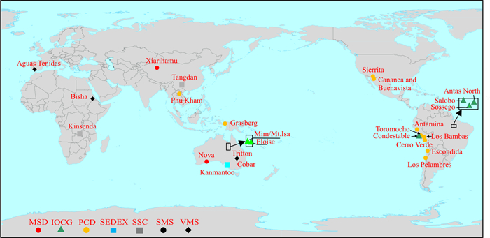
Trace elements of metallic minerals are important to constrain the formation processes and genetic types of ore deposits. Trace elements have been mainly focused on pyrite, magnetite, and sphalerite but have rarely been applied to chalcopyrite. To reveal the relationships between chalcopyrite trace elements and ore deposit types, ore petrography and LA-ICP-MS trace element of chalcopyrite in collected copper concentrate samples from porphyry copper deposits (PCD), magmatic copper-nickel sulfide deposits (MSD), sedimentary rock-hosted stratiform copperdeposits (SSC), iron oxide copper-gold deposits (IOCG), sedimentary exhalative deposits (SEDEX) and volcanogenic massive sulfide deposits (VMS) have been carried out. In chalcopyrite, Mn, Co, Ni, Se, Ag, Sn, Pb, and Bi contents are more than 1 000×10-6, and Ga, Ge, Mo, Cd, In, Sb, Te, Au and Tl contents are up to 100×10-6, which together indicate chalcopyrite is an important carrier for many trace elements. Antimony-Tl, In-Sn, Pb-Bi, and Mn-Ni in the chalcopyrite are positively correlated.Meanwhile, in chalcopyrite, Sb, Tl, In, and Sn mainly occur in the form of solid solution, Pb and Bi in the form of galena inclusions, and Mn, Co, As, Te, Ag, and Ni are both developed. Trace elements of chalcopyrite from PCD and VMS are variable. The concentrations of Ni and In in chalcopyrite from MSD are high and low, and Ge and Sn from SSC are higher and lower than other types, respectively. Moreover, the concentration of Se in chalcopyrite is higher from MSD and VMS, but is lower from SEDEX and SSC. Different concentrations of Ni, In, and Sn in the chalcopyrite are mainly related to different magmatism, and Se is principally controlled by temperature. The high concentrations of Ge in chalcopyrite from SSC may be related to ore-forming temperature and host rocks.Therefore, based on the above trace elements characteristics, Ni-Co and Ni-In diagrams can distinguish MSD from other deposit types, the diagram of Ni-Se can differentiate SEDEX, SSC from VMS, and the diagram of Ge-Sn is used to isolate SSC from SEDEX. In addition, the diagram of Co/Ni-Ag/Bi can differentiate between MSD and PCD, while Zn-Sn/In can discriminate IOCG from others to some extent.These first systematically proposed diagrams will provide a new reference for distinguishing the genetic types of deposits.

Structural graded ore-controlling rule and ore-controlling structural combination pattern of Daliangzi lead-zinc deposit in southwestern Sichuan
Yang Bo, Han Runsheng, Wu Jianbiao, Feng Zhixing, Ding Tianzhu, Wu Peng, Gong Hongsheng, Li Lingjie, Yuan Hang
2023, 42(1): 144-157. doi: 10.19509/j.cnki.dzkq.2022.0174
Abstract:

The Daliangzi lead-zinc deposit is located in the southwestern Sichuan ore concentration area in the southwestern margin of the Yangtze block, and the ore body′s occurrence obviously controlled by the structure.Aiming at the problem of unclear ore-controlling rules and combinations of ore-controlling structures, based on the theory and method of ore field geomechanics, through the identification of the mechanical properties of typical ore-controlling structures at different levels and the structural screening of different stages, the ore-controlling structures, assemblages and their formation mechanisms were clarified. The research shows that the metallogenic structural system is the late Indosinian NE structural belt.Under the NW-SE principal compressive stress, the resulting structures of different scales control the occurrence of the ore deposit, ore body and ore vein; At the same time, form various structural assemblages: strike-slip at the deposit scale is dominated by fault-fold tectonic assemblages, and orebody-scale assemblages are "multi-shaped", "in-shaped" and "black fractured zone" structural assemblages.This study provides an important basis for prospecting and exploration in the deep and peripheral parts of the deposit.

Sources and evolution of ore-forming fluids from the Saxi tungsten-beryllium deposit in southeastern Yunnan Province: Evidence from fluid inclusions and H-O isotopes
Sheng Xia, Zhang Da, Que Chaoyang, Bi Minfeng, Di Yongjun, Zu Shiyuan, Ma Huihui
2023, 42(1): 158-169. doi: 10.19509/j.cnki.dzkq.2022.0103
Abstract:

The Saxi tungsten-beryllium deposit is located in the Laojunshan tungsten-tin polymetallic metallogenic area in southeastern Yunnan. Determining the fluid nature, source, and evolution process of early layered orebodies and late vein-like orebodies and constraining their fluid geochemistry and isotopes can effectively explore the metallogenic mechanism of the Saxi tungsten-beryllium deposit, which is a collection of Laojunshan deposits. This study provides theoretical thinking for future prospecting work in the district. The formation of vein-like ore bodies in this deposit experienced a silicate stage, an oxide-sulfide stage, and a carbonate-fluorite stage. Scheelite and beryl were mainly formed in the first two stages. This article studies the fluid inclusions in quartz at different stages of the orebodies of the Saxi tungsten-beryllium deposit, including petrographic characteristics, microscopic temperature measurements, and laser Raman spectroscopy. The quartz sample's hydrogen-oxygen isotope composition in the ore-like ore body was tested. Three primary types of fluid inclusions (FIs) in vein-like ore bodies are detected, i.e.: liquid-rich FIs, gas-rich FIs, and aughter minerals bearing FIs. The gas phase composition of FIs is mainly H2O, with a small amount of reducing gas such as C2H2, and the liquid phase composition is also mainly H2O. From the silicate stage to the carbonate-fluorite stage, the peak homogenization temperature and salinity (NaCleq) of FIs are 240-360℃, 2.35%-13.81%; 220-310℃, 4.03%-9.86%, and 190-270℃, 2.41%-6.88%. From early to late, both homogenization temperature and salinity of the ore-forming fluid decreased obviously. The ore-forming fluid is generally a medium temperature, low salinity, CO2-poor NaCl-H2O fluid system. The δD and δ18O values of the quartz samples from early quasi-layered ore body are -102.8‰ to -99.0‰ and 11.7‰-13.0‰ respectively, and the corresponding δ18O value of the H2O value is 3.16‰-6.46‰. The δD and δ18O values of the quartz samplesfrom bulk oxide-sulfide section are -99.6‰ to -69.5‰ and 11.2‰-14.1‰ resoectively, and the corresponding δ18O value of H2O value is 3.08‰-6.73‰. This indicates that the ore-forming fluid mainly sourced from magmatic water mixed with a small amount of atmospheric precipitation or organic water.The fluid may boil, forming the precipitation of the main ore-forming minerals in the late vein-like ore body oxide-sulfide stage. The Saxi tungsten-beryllium deposit belong to a medium-to high-temperature hydrothermal system.

Research progress of carbonate rock diagenesis
Li Fengfeng, Ye Yu, Yu Yichang, Guo Rui
2023, 42(1): 170-190. doi: 10.19509/j.cnki.dzkq.2022.0209
Abstract:

Diagenesis is one of the important genesis of carbonate reservoirs, and it is also an important geological factor for the evaluation and prediction of carbonate reservoirs. First, the research methods of carbonate diagenesis were summarized, and the diagenesis mechanism and latest understandings of dissolution, dolomitization, cementation, neomorphism, silicification, compaction and pressolution were analyzed, and the auxiliary diagenesis factors such as bioturbation, tectonic disruption, hydrocarbon charging and micro-organisms were summarized. The evolution of the diagenetic environment under the control of tectonic-sequence were analyzed, and five sedimentary-diagenetic combinations were classified according to the sedimentary energy and diagenetic properties. Several issues needed to be improved in diagenetic research of carbonate reservoirs, which include: the diagenesis simulation system was different from the real stratigraphic environment; Diagenesis terminology was not standardized, and diagenesis mode was idealized and simplified; Lagoon, deep water and cold water and other unconventional carbonate diagenesis were in a low research degree; The double-edged influence of diagenesis on reservoirs and the quantitative research on reservoir reforms are insufficient. The development trend of carbonate diagenesis research include: by combining the history of stratum burial, the experimental simulation method will gradually move towards the real burial environment, and the diagenesis simulation software will continue to achieve modular integration and intelligence; The diagenesis model will be more refined and targeted, and the diagenesis can achieve quantitative research on the transformation of the reservoir; Research on the diagenesis mechanism of unconventional carbonate rocks will be more complete.

Zircon U-Pb geochronology of the Gongzhu Co gneiss in the Zhongba block from Ali, Tibet and its geological significance
Li Shengwei, Wei Meihua, Huang Ting, Liu Qiang
2023, 42(1): 191-203. doi: 10.19509/j.cnki.dzkq.2021.0085
Abstract:

The Zhongba block, an important tectonic unit of the western segment of the Indus-Tsangpo suture zone (ITSZ) in southern Tibet, is significant for determining tectonic affinity and paleogeographic reconstruction along the northern margin of the Gondwana. However, whether the continental basement of the Zhongba block exists is still a controversial issue. In this contribution, integrated with field observations, whole-rock geochemistry and zircon geochronology allow us to identify a biotite-plagioclase gneiss suite in the southern region of Gongzhu Co from the central Zhongba block. The gneiss has 64.09%-69.87% SiO2, 12.18%-18.30% Al2O3, 0.55%-0.79% TiO2 and 2.53%-3.54% K2O. It is enriched in light rare earth elements (LREEs) and has a high LREE/HREE ratio.It was proposed that the protoliths of the gneiss may be sedimentary rocks, dominated by feldspar sandstones, which had formed in an active continental marginal environment. Zircon dating result shows that the peak ages of inherited zircon cores are 950 Ma, 1600 Ma, and 2500 Ma, respectively, with the youngest age of ~630 Ma. Moreover, the metamorphic zircon rim yielded a weighted mean age of ~550 Ma. Based on these results, the Gongzhu Co gneiss was supposed to form in the Late Neoproterozoic (630-550 Ma) and subsequently underwent a high-grade metamorphism. Combined with previous results, the Gongzhu Co gneiss should represent the continental basement of the Zhongba block. This further implies that the Zhongba block belonged to northern margin of the Indian continent. Therefore, this study provides vigorous evidence for clarifying the characteristics of continental basement as well as tectonic affinity of the Zhongba block.

Characteristics, classification and genetic mechanism of pockmarks
Shen Ao, Sun Qiliang, Cai Dizhu, Xing Zihao
2023, 42(1): 204-217. doi: 10.19509/j.cnki.dzkq.2022.0144
Abstract:

Pockmarks are a kind of negative geomorphology formed by overpressure fluid spilling from the seabed. They are widely distributed in various underwater tectonic environments (such as continental margin basins and accretion wedges). Based on the recent research progress and achievements of pockmarks, this paper systematically divides the types of pockmarks according to their shapes, diameters, length width ratios, distribution characteristics and vertical filling modes. Moreover, this paper detailed introduces the main conditions and influence factors (such as diapir and fault)and deeply analyzes the genetic mechanisms of pockmarks. The local abnormal fluid pressure (overpressure) is the key factor to trigger the formation of pockmarks. According to the formation and leakage speed of overpressure during pockmark formation, the genetic mechanisms of pockmarks can bedivided into progressive, sudden and transitional three types. In the progressive formation model, both the formation and leakage processes of overpressure are slow. Whilst in the sudden formation model, the formation and leakage processes of overpressure are fast. For the transitional model, the formation and leakage processes of overpressure are faster than those of the progressive model but slower than those of the sudden model. The formation of pockmarks is affected by many factors, such as seawater and underlying strata. The physical and numerical simulation of dynamic overpressure formation and vertical migration to the seabed may be the future study directions of pockmarks.

Sinemurian-Pliensbachian boundary event (Early Jurassic): Current status and future challenges
Ge Yu, Shi Zhiqiang
2023, 42(1): 218-225. doi: 10.19509/j.cnki.dzkq.2022.0071
Abstract:

The Lower Jurassic is composed of the Hettangian, Sinemurian, Pliensbachian and Toarcian, among which the Toarcian oceanic anoxic events (T-OAE) have been widely studied. Depositions of black shales and negative excursions of both δ13Corg and δ13Ccarb at the Sinemuiran-Primbalian boundary, which has been recorded in the United Kingdom, France, Italy, Portugal and China.This event, known as the "S-P boundary event" (SPBE), characterized by significant carbon isotope, environmental and climatic perturbations in global scale. It is considered to be similar to the T-OAE, a well-known oceanic anoxic event, during which light carbon was released into the atmospheric system, although it is still unknown the sources of the carbon inputs. Research has so far dominantly focused on the marine strata in Europe, while few studies have evaluated the Lower Jurassic terrestrial strata. The Lower Jurassic lacustrine deposits are well developed in the Sichuan Basin, China. Similar to the T-OAE in the Daanzhai Member of Ziliujing Formation, the negative excursion of δ13Corg was recorded in the blackshales and shelly limestones of the Dongyuemiao Member, Ziliujing Formation, indicating that the SPBE likewise has an impact on the Early Jurassic ancient lake in the Sichuan Basin.

Structural characteristics and tectonic evolution of Mesozoic-Cenozoic faults in the Shunbei area, Tarim Basin
Cao Zicheng, Tang Daqing, Luo Mansong, Jiang Zhongzheng, Hong Caijun, Xia Yongtao, Wei Hua
2023, 42(1): 226-238. doi: 10.19509/j.cnki.dzkq.2022.0176
Abstract:

Oil and gas resources in the Shunbei area of the Tarim Basin are rich in Paleozoic strata.Recent petroleum exploration indicates that Mesozoic-Cenozoic sedimentary rocks have a good potential in hydrocarbon extraction. In this study, recently acquired 3D seismic surveys were used to systematically analyze fault types, geometrical characteristics, and evolution of Mesozoic-Cenozoic faults in the Shunbei area. The objective is to understand the characteristics and development mechanisms of faults that have the key controlling factors of hydrocarbon accumulation.In the Shunbei area, the dominant faults are tensional normal faults with few thrust faults and strike-slip faults. The district has many small scale, disorderly distributed faults. Combined with the regional setting and basin evolution stage, we suggest that the development of Mesozoic-Cenozoic faults in the Shunbei area experienced three tectonic cycles during the Indosinian, Yanshanian, and Himalayan periods. The structural position, middle Permian igneous rocks, and the sandy mudstone of the Lower Triassic Tongketuer Formation have significant control on fault evolution.Detailed interpretation of faults in the T90-T50 stratigraphic interval in the Shunbei area shows that the central part of the No.5 fault and south central part of the No.7 fault are two large faults that connect downward to the source rock of the basin. In these two areas, some faults cut upward through T90 to T50, which is good forvertical migration of hydrocarbon from Paleozoic to Mesozoic-Cenozoic strata and therefore are ideal locations for petroleum exploration.

Characteristics of strike-slip faults and exploration of fault-dissolution body in Xiaotangnan area of Tarim Basin
Li Liang, Sun Tingbin, Chen Yingnan, Zhang Yi, Wang Yushan, Wang Shuo, Zhao Jing, Wang Yadi, Li Dong
2023, 42(1): 239-245. doi: 10.19509/j.cnki.dzkq.2022.0148
Abstract:

Faults play an important role in the exploration and development of Ordovician carbonate fracture-cavity hydrocarbon reservoirs in Tarim Basin, including controlling reservoirs development and hydrocarbon accumulation.The structure and evolution characteristics of strike-slip faults are analyzed based on the new 3D seismic data in Xiaotangnan area. The results show that there are three NE strike-slip faultsand they have linear, horse-tailed, braided and half-flowered combinations in the Xiaotangnan area.Two sets of deep and shallow fault systems were developed longitudinally. The deep strike-slip faults were formed in the Early to Middle Caledonian, showing steep or flower-shaped pattern, while the shallow faults were formed in the Late Caledonian to Hercynian, showing negative flower-shaped strike-slip faults. The Shunnan 4 extension fault zone in the study area has obvious zoning characteristics, which shows a linear fault zone, horsetail fault zone from south to north.In the cavern fault area, the strata are seriously broken, which is conducive to karstic process, and the fault solution reservoir is more developed, so it is the preferred area for risk exploration.This study has certain guiding significance for the exploration of Ordovician fault-solution reservoirs in this area.

Characteristics of Paleogene compression-extension deformation and exploration significance in the Baiyun East area, Pearl River Mouth Basin
Wang Fuguo, Zhang Xiangtao, Mei Lianfu, Yan Hui, Liu Baojun, Zhang Zhongtao, Liu Jun
2023, 42(1): 246-252. doi: 10.19509/j.cnki.dzkq.2022.0179
Abstract:

The Baiyun East area is one of the two favorable reservoir-forming areas in the Baiyun Sag in the Pearl River Mouth Basin. At present, exploration is facing the stage of turning to the deep strata of the Paleogene. In recent years, drilling has found that the sandstone in the deep gentle slope zone becomes less abundant, which contradicts the development model of extensional half-graben reservoirs. Based on the comprehensive interpretation of deep reprocessing 3-D seismic data and drilling data, a full 3-D structural analysis of the Paleogene and subbasement detachment surface in the Baiyun East area is carried out. The basin evolution stages are reclassified according to the dynamic mechanism. The tectonic sequence has been modified from a passive rift cycle to three cycles of passive rift-active rift-passive rift.The tectonic episode is subdivided into six curtains from three stage cycles: fault episode-fault depression conversion episode-depression episode is subdivided into rift two subepisodes-fold two subepisodes-rift shrinking episode-drift episode, and the subdivision scheme better reflects the law of strata deformation.A new model of compression-extension deformation of the Paleogene basin has been established in the eastern Baiyun area. In the development process of the extensional structure, the new model coordinates the Paleogene structure-sedimentary response of the eastern Baiyun area. This model enriches the evolutionary model of the South China Sea Basin and provides support for the exploration of new deep areas in the Baiyun Sag.

Preservation condition evaluation of normal pressure shale gas in the Wufeng and Longmaxi Formations of basin margin transition zone, Southeast Chongqing
Liu Yisheng, Jin Jineng, Pan Renfang, Li Xiaotian, Zhu Zhengping
2023, 42(1): 253-263. doi: 10.19509/j.cnki.dzkq.tb20210768
Abstract:

Despite the huge gas resources in the shale of the Upper Ordovician Wufeng Formation and Lower Silurian Longmaxi Formation in the Sichuan Basin and its periphery, commercial breakthroughs are mainly located inside the basin.The Southeast Chongqing, located in the basin margin transition zone, was intensively deformed by tectonic activities. As compared to the gas enrichment model of the Wufeng-Longmaxi Shale inside the basin, the basin margin transition zone requires better preservation conditions.According to the complicated structure patterns of the Wufeng and Longmaxi Formations in Southeast Chongqing, the preservation conditions are analyzed by the super position of structure evolution, uplift and exhumation, fault development, structural style, roof and floor conditions, and formation pressure. The results show that the basin margin is seriously uplifted and exhumated, with well-developed faults, forming a series of residual structural styles; natural gas leakage in the area close to the exhumation boundary and major faults contributed to the low formation pressure coefficient (less than 1.2). Sangtuoping syncline and Wulong syncline show good preservation conditions of shale gas because of the relatively less large faults and the far away from the exhumation area. Therefore, the late uplift, exhumation, and fault development are the main reasons for the gas leakage and the change of formation pressure from overpressure to normal pressure across the basin margin. Tectonic deformation is the fundament of current shale gas preservation in the structures of narrow and steep residual anticlines, broad and gentle residual synclines, and residual slopes. Finally, an evaluation standard was established for the preservation conditions of normal-pressure shale gas. According to this standard, favorable target areas are divided for normal shale gas in the study area.

Analysis of the pore structure of tight sandstone by high-pressure mercury injection combined with fractal theory: A case study of the Heshui area in the Ordos Basin
Lu Zhendong, Liu Chenglin, Zang Qibiao, Wu Yuping, Yang Xiya, Yang Hong, Zeng Xiaoxiang, Li Wenda
2023, 42(1): 264-273. doi: 10.19509/j.cnki.dzkq.tb20210203
Abstract:

Pore structure is the key element of tight sandstone reservoirs, which restricts the accumulate and flow of oil and gas in reservoirs. The pore structure is one of the key and difficult point of unconventional oil and gas exploration and development. In this paper, ten dense core samples from the Upper Triassic Yanchang Group 7 section in the Heshui area of the Ordos Basin are selected to carry out experiments, including high-pressure mercury pressure and X-diffraction. Fractal theory is used to analyze the characteristics of pore throats, then the relationship between fractal dimension and reservoir physical properties, pore structure and mineral content is analyzed. The results show that according to the mercury pressure curve and pore structure, the reservoir is divided into categories Ⅰ, Ⅱ and Ⅲ, its reservoir performance and seepage capacity decrease in turn, and the microheterogeneity is enhanced. Different types of reservoirs have different fractal characteristics: according to the inflection points of fractal curves 0.05 and 0.02 μm. The pore size of class Ⅰ reservoirs is divided into large pores (> 50 nm) and medium pores (50-6 nm) by combining the actual situation with the standard of pore size division proposed by IUPAC. According to the inflection point, the reservoirs of classes Ⅱ and Ⅲ can be divided into medium pores a (50-20 nm) and mesoporous B (20-6 nm). The average fractal dimension increased, which was 2.619 3, 2.745 4 and 2.852 6, respectively, and the heterogeneity gradually increased. The main permeability is contributed by fewer large pores, and the fractal dimension mainly reflects the heterogeneity of pore size. The fractal dimension is related to some minerals. Mineral composition and content are the internal factors that determine the fractal dimension and then affect the quality and pore structure of reservoirs.

Investigation of pore structure and permeability estimation models of Kongdian Formation glutenites in the Bozhong 19-6 Gasfield
Song Chen, Yang Bing, Zhang Chaomo, Zhu Boyuan, Zhang Zhansong
2023, 42(1): 274-285. doi: 10.19509/j.cnki.dzkq.2022.0093
Abstract:

The pore structure of glutenite in Bozhong 19-6 Gasfield is complicated. In order to improve the estimation accuracy of permeability, it is necessary to start with the pore structure and find the pore structure factor with the best correlation with permeability. Taking the pore structure and permeability of 43 Kongdian Formation glutenites as the research object, using rock casting thin slices to determine the pore types, and obtaining pore-throat size distribution characteristics and pore structure parameters through high-pressure mercury intrusion. Combining pore types and pore structure parameters to analyze the relationship between pore structure and permeability, a permeability evaluation model based on pore structure parameters was established. Studies have shown that there are differences in the pore structure between different types of dissolved pores. The pore structure of dissolved pores in the grain is the best, and the pore structure of dissolved pores in the cement is the worst. The physical properties of glutenite with different types of dissolution pores vary greatly. The rock samples with intragranular dissolution pores and no cement dissolution pores have the best physical properties. Different pore structure factors have inconsistent degrees of permeability control. Among them, the permeability model which based on pore throat size, connectivity, ratio and shape has the highest accuracy. The large pore throat radius and good connectivity of the dissolved pores in the glutenite grains of the Kongdian Formation of BZ19-6 Gasfield are the main reasons for the good reservoir and seepage capacity of this kind of rocks. The average pore throat radius, mercury removal efficiency, average pore throat volume ratio and fractal dimension are suitable for estimating the permeability of glutenite reservoirs with complex pore structures and (extremely) low porosity and permeability, in order to provide technical support for the permeability evaluation of glutenite reservoirs inBozhong Depression, Bohai Bay Basin.

Microstructure characteristics and genetic analysis of tight reservoirs with different provenance systems: A case study of Fanjiachuan and Nanliang region of Chang 6 reservoir in Longdong area, Ordos Basin
Wang Chonghuan, Wei Qinlian, Hu Rong, Xiao Ling
2023, 42(1): 286-298. doi: 10.19509/j.cnki.dzkq.2021.0258
Abstract:

Ordos Basin is rich in tight oil and gas resources.The multi-source system controls the development of Chang 6 reservoir in Longdong area. However, the current study on the microstructural characteristics of sand bodies is weak, which has restricted the exploration and evaluation of Chang 6 reservoir in this area. In this study, we used microstructural analysis by thin sections, X-ray diffraction and constant-speed mercury intrusion analysis to identify the microstructure characteristics of reservoirs, and to compare the influence of sedimentary microstructures on reservoir development. Based on these information, we establish corresponding pore evolution models, and discuss the control mechanisms of main diagenesis on reservoir densification. Our results can concluded as followed.①Throats are the main factor to control the permeability of the reservoir. The northeast provenance area shows better throat development and higher permeability than the western provenance area; ②As the permeability increases, the contribution of large throats to the permeability increases significantly in Nanliang area; ③Sedimentary microfacies can be important factors to control the physical properties of sand bodies in different provenance systems. The physical properties of sandy clastic flow and turbidity current sand bodies are better in Nanliang area than those in Fanjiachuan area.Compaction can be the major reason for reservoir densification.Affected by the content difference of illite and chlorite in reservoirs of different provenance systems, the amount of compaction reduction in the northeast provenance deposition area (19.29%) is less than that in the western provenance deposition area (22.32%).The new results have guiding significance to evaluate the late evaluation of tight oil from different provenance systems.

Quantitative well logging evaluation of diagenetic facies of deep and ultra deep tight sandstone reservoirs: A case study of Bozi-Dabei area in Kuqa Depression
Liu Hongkun, Ai Yong, Wang Guiwen, Chen Kangjun, Cai Deyang, Cao Juntao, Xie Yuqiang, Li Dong, Lai Jin
2023, 42(1): 299-310. doi: 10.19509/j.cnki.dzkq.2022.0256
Abstract:

Bashijiqike Formation in Bozi-Dabei area develops deep and ultra deep tight sandstone reservoirs. It is urgent to reveal the main controlling factors of reservoir quality and establish a matching well logging evaluation method for high quality reservoirs. In order to quantitatively evaluate the diagenetic facies, based on the data of core, thin section, cast thin section and scanning electron microscope and etc., the petrology, physical properties, diagenesis types and intensity, diagenetic minerals and other characteristics of the tight reservoir of Bashijiqike Formation in Bozi-Dabei area were studied. Based on quantitative calculation of ompaction rate, cementation rate, dissolution pore content and comprehensive diagenetic coefficient, the diagenetic facies were classified according to characteristics of diagenesis intensity and its combination. The reservoirs can be divided into three types of diagenetic facies, i.e., medium compaction weak dissolution facies, carbonate cemented facies and compaction dense facies. Through the fitting analysis of thin section data and well logging data, the well logging calculation model of diagenetic comprehensive coefficient Cg was established, and the method of quantitative identification of reservoir diagenetic facies were established. The well logging data of Well X1, Well Y1 and etc were processed.The reliability of the model was verified by matching the identification results with physical property analysis and casting thin section. The establishment of well logging quantitative characterization method of diagenetic facies can provide guidance for "sweet spot" prediction.

Quantitative simulation of the densification process of sandstone reservoir in the Xu 3 Member of Xujiahe Formation in western Sichuan Depression, Sichuan Basin
Chang Yu, Liu Mingjie, Zhang Zhuang, Ye Sujuan, Yang Yingtao, Wu Ling, Zhang Ling, Nan Hongli, Tan Xiucheng, Zeng Wei, Lian Chengbo
2023, 42(1): 311-323. doi: 10.19509/j.cnki.dzkq.2022.0177
Abstract:

In order to clarify the densification process and quantitatively restore the porosity evolution of the Xu 3 Member sandstone reservoir in western Sichuan Depression, the diagenesis of the Xu 3 Member was system atically analyzed using thin sections, scanning electron microscope and fluid inclusion analysis. Meanwhile, the relationship between diagenesis and porosity evolution was discussed.Based on the study of formation burial history and thermal evolution history, a mathematical model of porosity evolution for the Xu 3 Member sandstone was established to clarify the densification process of sandstone reservoir using the principle of effect simulation, that is, the specific diagenesis was not simulated, but the comprehensive superposition results of various diagenesis were simulated through geological parameters.It found that lithic quartz sandstone and lithic sandstone were mainly developed in the Xu 3 Member, and sand stone underwent compaction, cementation, dissolution and others. Among them, compaction and cementation are the main destructive diagenesis and occur in the whole evolution process, while dissolution is the main constructive diagenesis and only occurs in a specific evolution stage with window characteristics.Based on the current observation of the relationship between porosity and depth of sandstone, the sandstone had undergone compaction and cementation, corrosion, and compaction and cementation after corrosion.As a result, the porosity evolution could be divided into three stages: normal compaction stage, pore increasing stage during corrosion andnormal compaction after corrosion.Furthermore, the porosity evolution could be divided into porosity decreasing model and porosity increasing model.These two models were superimposed on the three stages of porosity evolution, and a three-stage piecewise function characterized the porosity evolution was proposed.Using this function, the total porosity evolution simulation of sandstone reservoir could be realized.Simulation results found that the Xu 3 Member in western Sichuan Depression was dominated by early densification due to compaction and early cementation using the proposed quantitative model.

Identification of the geochemical anomalies using the catchment basin analysis: A case study of 1∶50000 geochemical survey of stream sediments in Wulasitai region, East Kunlun Orogenic Belt
Huang Xiaokun, Wei Junhao, Shi Wenjie, Zhang Xinming, Gao Qiang, Wang Shuang
2023, 42(1): 324-338. doi: 10.19509/j.cnki.dzkq.2021.0093
Abstract:

Geochemical survey of stream sediments is an effective technology for mineral prospecting. The extraction of geochemical anomalies in stream sediments based on catchment basins has always been one of the research hotspots.The catchment basin analysis method is proposed based on Sample Catchment Basin Analysis (SCBA)in this paper, and it is used to identify geochemical anomalies in the Wulasitai region, East Kunlun Orogenic Belt in Qinghai Province.Catchment basins are divided by a high-precision DEM, and the Au, Ag, and Pb factor loadings of 1∶50000 stream sediments are measured by the catchment basin analysis. During the extraction process, a variety of geomorphic parameters such as main stream slope, relief ratio, catchment basin area, are used as the sediment delivery ratios for residual correction calculation, and the geochemical background and anomalies are separated by the C-A fractal modeling. The anomaly extraction results show that the area of the catchment basin is the most suitable parameter as the sediment delivery ratio to participate in the downstream attenuation correction. The catchment basin method can effectively identify and extract geochemical anomaly information.Anomalies correspond well to the spatial location of ore deposits, and can provide beneficial information for the next step of mineral prospecting.

Geochemical characteristics and environmental implications of source rocks of the Dongying Formation in southwest subsag of Bozhong Sag
Yang Hong, Liu Chenglin, Wang Feilong, Tang Guomin, Li Guoxiong, Zeng Xiaoxiang, Wu Yuping
2023, 42(1): 339-349. doi: 10.19509/j.cnki.dzkq.2021.0077
Abstract:

Source rocks of the Dongying Formation are widely distributed in the Bozhong Sag. It is of great significance to clarify the characteristics and paleoenvironment of the source rocks to promote conventional and unconventional oil and gas exploration in the Bozhong Sag. In this study, organic and inorganic geochemical experiments were carried out on the source rock samples collected from the Dongying Formation in the Bozhong Sag, with aims to analyze the quality and paleoenvironment and compare it with the Shahejie Formation. The results show that: ①the characteristics of source rocks in different layers of the Dongying Formation are significantly different from those in Es1-2.The abundance of organic matter in the lower and third members of the Dongying Formation (Ed2L and Ed3) is high and has reached the mature-high maturity stage. The organic matter of the Dongying Formation is mainly type Ⅱ. ②According to the Pr/nC17-Ph/nC18 charts, the source of organic matter in the Dongying Formation is mixed type, which is obviously different from the low algae of Es1-2.③The paleoenvironment during the formation of source rocks was analyzed by combining the contents or ratios of 16 elements, such as Sr/Cu, Mn/Fe, Pr/Ph and the gammacerane index. Different from the strong reduction-salinized lacustrine basin in the arid climate of Es1-2, the Dongying Formation was formed in a warm and humid climate, accompanied by strong terrigenous input, and controlled in a weakly oxidized freshwater environment. Longitudinally, the paleoclimate changes little from Ed3 to Ed1, and the water salinity is basically the same, but the water depth becomes shallower and the water oxidation conditions show a trend of increasing gradually.④Using Co and La contents to quantitatively restore the paleo-water depth during the deposition of the Dongying Formation, and suggests that Ed3 (50.4 m)>Ed2 (35.7 m)≈Es1-2(33.2 m)≈Ed1(31.7 m). The calculated results are consistent with the previous qualitative results of paleo-water depth.

Deposition environment and provenance of the Palaeogene Shahejie Formation in Nanpu Sag: Evidences from trace and rare earth element geochemistry
Jing Yuqian, Lei Chuang, Liu Kedong, Li Zhenhua
2023, 42(1): 350-359. doi: 10.19509/j.cnki.dzkq.2022.0131
Abstract:

In order to reveal the formation mechanism of the organic-rich shales of the Shahejie Formation in Nanpu Sag, the depositional environment and provenance were investigated in detail through analyzing trace and rare earth elements(REE) geochemical characteristics. The results show that the trace elements Li, Cs and Bi are enriched, Cr and Sn are relatively depleted, and other trace elements are close to those in the upper continental crust(UCC).The total amount of REE vary widely, which is close to or higher than the average value in the UCC, and the supply of terrestrial source debris is adequate. The REE allocation pattern shows light rare earth element(LREE) enrichment with a high degree of divergence, and a relative deficit of heavy rare earth element(HREE) with a low degree of divergence. Eu negative anomaly is obvious, Ce is basically normal. The variations of Sr abundance and Sr/Ba ratio reflect that, in Nanpu Sag, the lake water was separated to a certain extent, and the fresh water, brackish water and saline water coexisted during sedimentary period of the third member of Shahejie Formation(Es3), and during these dimentary period of the first member of Shahejie Formation(Es1), the connectivity of lake water was enhanced, which was dominated by brackish water.The values of the V/(V+Ni), Th/U, δCe, and Ceanom comprehensively delineate the water body presented suboxic environment with moderate stratification. Respectively, the source Ba content indicated the water body was dominated by high paleoproductivity. The REE assemblage characteristics suggests that the provenance of Shahejie Formation were primarily derived from Yanshanian granites developed in Yanshanian fold belt and a small amount of sedimentary rocks. The development of organic-rich shales in the Shahejie Formation in Nanpu Sag is closely related to paleoenvironment and paleogeography, which can be summarized as the followings: ①suitable paleosalinity as well as sufficient nutrients at water body contributed to the booming of various planktonic algae, improving the production efficiency of the aquatic organic matter; ②suboxic water column slowed down the degradation of oxygen-sensitive material during the burial process, enhancing the preservation efficiency of sedimentary organic matter.

Research progress on the application of dynamic grids in the numerical simulation of unsaturated-saturated interfaces
Liu Ling, Wei Yaqiang, Chen Jian, Li Lu, Niu Haobo, Yin Leyi
2023, 42(1): 360-368. doi: 10.19509/j.cnki.dzkq.tb20220103
Abstract:

In order to discuss the future development trend of structural and unstructured dynamic grid technology in the field of unsaturated-saturated groundwater numerical simulation, this paper summarizes the research status of unsaturated-saturated coupled numerical simulation, introduces the principle of dynamic grid technology and the deformation method of moving boundary structure and unstructured grid, summarizes the application status and shortcomings of dynamic grid technology in the unsaturated-saturated interface, and discusses the future development trend of related research. The review shows that both structural dynamic grids and unstructured dynamic grids have their inherent advantages and disadvantages, and the combination of structural/unstructured hybrid grids and multiple dynamic boundary treatment methods has important application value in the research of unsaturated-saturated coupling numerical simulation. When simulating the change of phreatic surface, a variety of mesh deformation methods can be combined. When the change of the position and shape of the phreatic surface is small, the spring method is used to update the mesh; When the position of the water table changes significantly but the shape changes little, the overlapping structure dynamic grid technology or the overlay method is used to update the grid; If the shape of the water table changes greatly, the grid reconstruction method is used to update the grid, so as to more accurately simulate the change and movement of the unsaturated-saturated interface. Relevant research provides scientific guidance for the coordinated prevention and control of unsaturated zone soil and saturated zone groundwater of the site.

Spatial distribution and controlling factors of sediment nitrogen forms in the mangrove wetland at Dongzhai Port, Hainan Province
Zhu Pengguang, Gan Yiqun, Lai Yongyi, You Yue, Jiang Ying
2023, 42(1): 369-377. doi: 10.19509/j.cnki.dzkq.2022.0255
Abstract:

The occurence of nitrogen in sediments directly affects the process, pathway and contribution of nitrogen in the nature, therefore exploring the environmental geochemical behavior of different nitrogen speciation in sediments is of great significance for studying nitrogen geochemical cycle. In this study, the surface sediment and sediment core were collected in the mangrove wetland at Dongzhai Port, Hainan Province.The different forms of transferable nitrogen were analyzed via hierarchical extraction.The spatial distribution characteristics and influencing factors were investigated. The results showed that the contents of total nitrogen (TN) and total transferable nitrogen (TTN) in the sediments ranged from 1 149.2 to 1 690.6 mg/kg and from 464.6 to 647.5 mg/kg, respectively, both of which presented a decreasing trend from the upstream to the estuary. The strong oxidant extracted nitrogen (SOEF-N) is the major nitrogen species in TTN, and positively correlated with TTN contents. According to C/N ratio, the organic matter in the study area is mainly from the discharge of a large number of pollutants.The significant positive correlation between TN, water content and TOC in the mangrove columnar sediments in Dongzhai Port, indicates that nitrogen and organic matter have similar sources.

Progress of copper isotope and its application in environmental pollution tracing
Han Yan, Hu Yating, Wang Qian, Shi Minghui, Zhou Lian
2023, 42(1): 378-387. doi: 10.19509/j.cnki.dzkq.2022.0178
Abstract:

In recent years, environmental problems have been a hot topic of social concern, such as heavy metal pollution in the atmosphere, soil and sediment, which are closely related to our life.To solve the heavy metal pollution in environment, the key is to determine the source of pollution.With the rapid development of stable isotope tracer technology, further achievements have been made in the study of the traceability of heavy metal pollution. Meanwhile, isotope tracer technology has become an important means in the traceability of heavy metal pollution.To better understand the isotope tracer technology application in environmental pollution sourcing, having the copper isotope as an example, the basic properties of copper, isotope fractionation in the geochemical process, processing and purification different types of samples, isotope analyze technique, tracer technique, the meta model has carried on the brief summary.This paper further describes the end members(natural input source and artificial input source), pollution path and pollution degreeof river pollution, smelter pollution and atmospheric particulate pollution. Finally, the application of isotope tracer is summarized and prospected.

Key technology and application of integrated management of urban pan-spatial 3D model data
Xu Dexin, Peng Hanfa, Xiao Jie, Yang Qibo, Li Sanfeng, Liu Hui
2023, 42(1): 388-397. doi: 10.19509/j.cnki.dzkq.2022.0182
Abstract:

With the rapid development of urban 3D geological information system and its application, the demand for visualization accuracy of geological data is increasing. Geological survey data are often multi-source, multi-dimensional, massive, multi-topic, multi-scale and multi-temporal, which makes it difficult to store, organize and manage 3D data.Therefore, it is of great interest for scholars in the field of urban geological information science to efficiently manage and effectively utilize the complex and massive geological data to solve various complex geological problems and serve the society. Based on the construction process of a full-space map of the multi-factor urban geological survey of Wuhan, this paper systematically explores the key technologies in the construction of the One Map system for urban geological survey and puts them into practice. Four aspects are explicitly considered, namely, distributed storage and fusion management of a multi-source 3D models, lightweight full-space 3D model construction, fast rendering of multi-source heterogeneous massive 3D data, and application of 3D model analysis in browser, and an example is put forward. It realizes the efficient integration of large-scale and high-precision 3D geological models at the city level, improves the visualization expression effect of multi-factor urban geological survey results, and lays a solid foundation for the application of 3D geological models.

Evolution of land subsidence and comparative study on multi-source monitoring methods in New Airlines City of Beijing
Liu He, Luo Yong, Lei Kunchao, Cui Wenjun, Qi Minghuan, Zhao Long, Kong Xiangru
2023, 42(1): 398-406. doi: 10.19509/j.cnki.dzkq.tb20210456
Abstract:

To reveal the evolution law of land subsidence in the New Airlines City of Beijing, the characteristics of land subsidence in this area are analyzed by combining bedrock standard-layered standard and leveling survey, and the comparative study and evaluation are carried out with different monitoring methods. The results show that: ①In recent ten years, the amount and proportion of subsidence in the shallow stratum of the Xinhangcheng area are smaller and smaller, the proportion of subsidence decreased from 67.62% in 2009 to 19.69% in 2019, while the amount and proportion of subsidence in the middle stratum and deep stratum are increasing with time, the proportion of middle stratum subsidence increased from 21.39% in 2009 to 35.83% in 2019, and the proportion of deep stratum subsidence increased from 10.99% in 2009 to 44.48% in 2019;the water level of the shallow aquifer changes periodically, while that of the middle stratum and deep aquifer decreases continuously, the strata continue to compress in the periodic change of water level. ②According to the results of the level survey and groundwater dynamic monitoring over the years, the accumulated settlement from north to south in the research area gradually decreases. After fitting the data of land subsidence and groundwater level, it is found that there is a certain correlation between them, the correlation increases with the increase of water level drop, and there is a positive correlation between them. ③The error value of the static leveling system of bedrock standard layered standard and artificial leveling system after mutual correction of the same monitoring point and different depth data is very close, which conforms to the normal distribution law, and the correlation coefficient of monitoring data of different depth is 0.993 6; comparing the two methods has advantages and disadvantages, it is suggested to obtain the settlement information and data in many aspects based on the actual situation, to meet the regional requirements different demands of the monitoring and prevention of the grade land subsidence.

Applications status and prospects for using unmanned aerial vehicle in sedimentology
Sun Xinyao, Wang Ping, Zhang Hong, Guo Yujie, Guo Fei
2023, 42(1): 407-419. doi: 10.19509/j.cnki.dzkq.2022.0145
Abstract:

The unmanned aerial vehicle (UAV) is an important tool for acquiring digital images of the surface and collecting samples. Recently, it has been becoming an emerging research tool in sedimentology, changing the paradigm of sedimentology.However, UAV-based sedimentological research in China is still in its infancy. This paper reviews the recently important applications of UAVs in sedimentology, discusses critical technical backgrounds and existing problems involved, and summarizes as well as prospects for future applications of UAVs in sedimentology to provide references for subsequent research.Software and hardware requirements for applications of UAVs in sedimentology and typical case studies are reviewed from three aspects: 3D digital reconstruction of sedimentary outcrops, extraction of high-resolution sedimentary textures and structure features, and UAV-assisted sample collection. The use of UAV photogrammetry to construct digital outcrop models facilitates the observation of geometry, sedimentary facies, and facies associations for sedimentary outcrops from multiple spatial scales and perspectives. Combined with professional software for digital outcrop model interpretations, it allows for remote and efficient extractions of sedimentary textures and structure features such as grain size, cross-bedding, and bioglyph on large spatial scales. UAV-based digital outcrop models can also be applied to field practice teaching in sedimentology in the future. Also, UAVs can be modified to assist in collecting sediment samples like ice cores. The application of the UAV technology in sedimentological research has the advantages of low cost and high efficiency, ensuring the timeliness and continuity of data, and increasing safety in fieldwork. However, UAV technology also has disadvantages in data repeatability, point cloud processing, and image or model quality. Further improvements can be made in the future with the help of artificial intelligence and by developing standard specifications for UAV image acquisition and processing flow.

Application of NMR logging while drilling in fluid identification of low resistivity reservoirs in Wenchang Oilfield, South China Sea
Luo Yuhu, Zhang Hengrong, Tang Di, Wu Yixiong, Yuan Wei
2023, 42(1): 420-428. doi: 10.19509/j.cnki.dzkq.2022.0227
Abstract:

In the development of low resistivity reservoirs in Wenchang Oilfield of South China Sea, NMR logging while drilling provides porosity, permeability and other parameters in a safe and efficient logging way, and plays a key role in qualitative identification of light oil. In order to further improve the application value of NMR logging while drilling in fluid identification of low resistivity reservoir in Wenchang Oilfield, starting from two influencing factors which is pore structure and fluid properties, T2 spectrum oil-bearing characteristic index was proposed, and pure water spectrum reconstruction was introduced to carry out fluid quantitative identification. The T2 spectrum oil-bearing characteristics index method was based on eliminating the influence of pore structure, and by using the transverse relaxation time difference between light oil and water to extract the real tail phenomenon of light oil, so as to achieve the purpose of quantitative identification of fluid.The water spectrum reconstruction method used the spherical tube model and the normal distribution model to construct the bound water spectrum and the movable water spectrum respectively, which the sum of the two spectrum is pure water spectrum. The information of fluid properties is extracted by comparing with the actual measured NMR T2 spectrum, so as to identify the fluid properties. The two methods have good applications to the fluid identification of low resistivity reservoirs in Wenchang Oilfield.These two methods can play important roles in the quantitative identification of reservoir fluids such as low resistivity reservoirs and water flooded reservoirs.