| Citation: | XU Wei, YANG Defang, CHEN Lihao, LUO Kaishu, ZHANG Shengpeng, ZHANG Yanze, LI Long, CHEN Gang. Fusion processing of multisource remote sensing images for extracting characteristic information from the Geladandong Snow Mountain area[J]. Bulletin of Geological Science and Technology, 2024, 43(2): 370-385. doi: 10.19509/j.cnki.dzkq.tb20220545

|
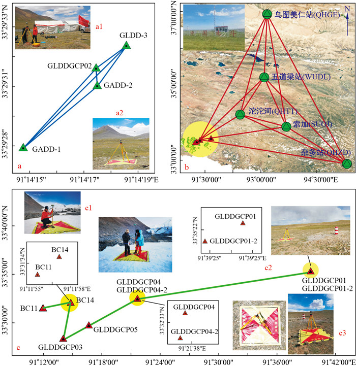
In July 2022(Beijing time), the glacier survey group and mountaineering group of the China University of Geosciences (Wuhan) performed the "Second University Students' Scientific Expedition to the Yangtze River" in the Geladandong Snow Mountain area.
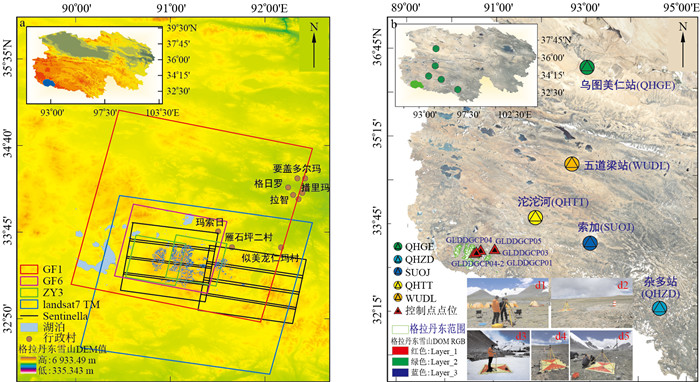
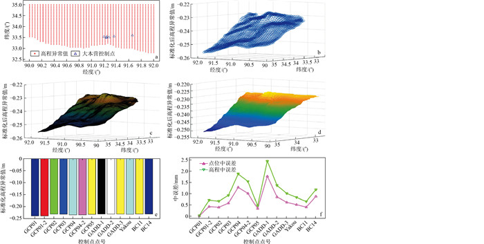
To analyse the spatial and temporal characteristics of glaciers in this region, scientific research data were combined with optical remote sensing image interpretation, InSAR deformation information extraction, LiDAR altimetry measurements, and high-precision geodetic survey data to conduct multisource remote sensing image fusion processing research. Aerial triangulation encryption, frequency domain image matching, the waveband ratio method, and visual interpretation were used to extract DOM, DSM, glacier area and number distribution information from high-resolution satellite GF1, GF6, GF7, ZY3, and Landsat 7 remote sensing images of Geladandong Snow Mountain and typical glaciers.Sentinel-1A and ICESat-2 images were used, supported by the cross-correlation offset tracking method in the SAR image space domain, to extract glacier surface velocity and elevation changes, respectively. The 3D spatial coordinates and elevation outliers of all the control points were calculated for the BDS CORS station in Qinghai Province using the Gamit/Globk double difference ionospheric combination model, real-time extended (RTX), and real-time kinematic (RTK) techniques.
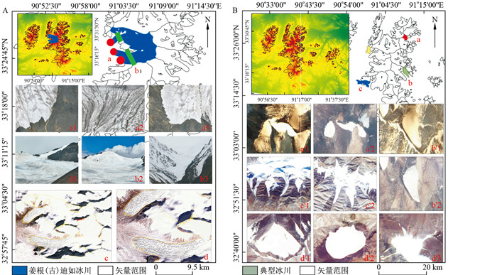
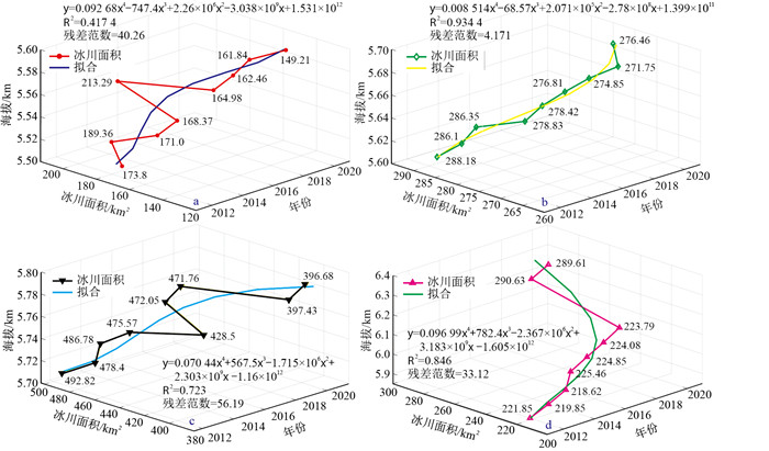
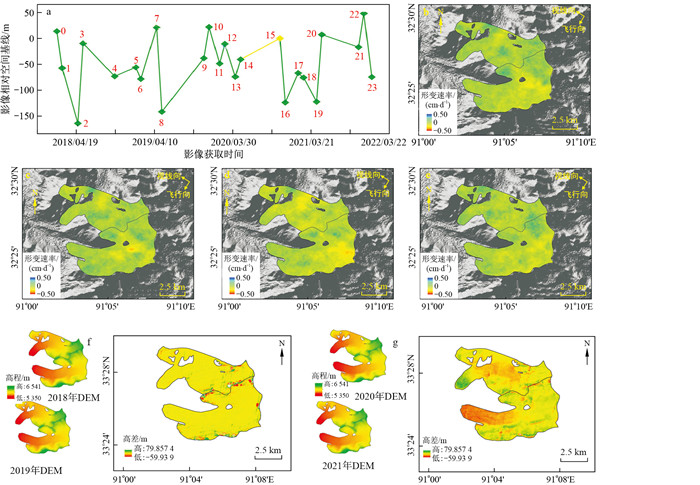
The results revealed 512 glaciers in the Geladandong Snow Mountain area, with an average annual growth rate of 3.12%, an area of 1 111.96 km2, and an average annual retreat rate of 0.63%.The average daily maximum velocity of the Jianggen (gu) Diru glacier is 0.25 cm/d, and the average annual maximum velocity is 91.25 cm/a. The maximum retreat value, accumulation value and annual change rate of Jianggen (gu) Diru glacier on the south side and north side are -74.63 m, 38.44 m, -5.29 m/a to 3.09 m/a, -39.17 m, 35.74 m, -3.02 m/a to 2.85 m/a, respectively. The precision of the regional quasigeoid refinement model and the errors at all control sites both attained mm levels.
The aforementioned findings can provide data support for subsequent research on glaciers in this region.

| [1] |
张艳, 孙杰, 于长春, 等. 基于多源遥感数据的第四系覆盖物分类方法研究: 以内蒙古旗杆甸子幅1: 5万填图试点为例[J]. 地质科技情报, 2019, 38(2): 281-290. https://www.cnki.com.cn/Article/CJFDTOTAL-DZKQ201902034.htm
ZHANG Y, SUN J, YU C C, et al. Classification of Quaternary coverings in desert grassland shallow cover area based on multi-source remote sensing data: A case of 1: 50 000 pilot geological mapping in Qigandianzi, Inner Mongolia[J]. Geological Science and Technology Information, 2019, 38(2): 281-290. (in Chinese with English abstract) https://www.cnki.com.cn/Article/CJFDTOTAL-DZKQ201902034.htm
|
| [2] |
陈兰, 范宣梅, 熊俊麟, 等. 藏东南多依弄巴流域冰湖溃决危险性评价[J]. 地质科技通报, 2023, 42(2): 258-266. doi: 10.19509/j.cnki.dzkq.tb20220235
CHEN L, FAN X N, XIONG J L, et al. Hazard assessment of glacial lake outbursts in the Doyinongba Basin, southeastern Tibetan Plateau[J]. Bulletin of Geological Science and Technology, 2023, 42(2): 258-266. (in Chinese with English abstract) doi: 10.19509/j.cnki.dzkq.tb20220235
|
| [3] |
刘时银, 姚晓军, 郭万钦, 等. 基于第二次冰川编目的中国冰川现状[J]. 地理学报, 2015, 70(1): 3-16. https://www.cnki.com.cn/Article/CJFDTOTAL-DLXB201501002.htm
LIU S Y, YAO X J, GUO W Q, et al. The contemporary glaciers in China based on the Second Chinese Glacier Inventory[J]. Acta Geographica Sinica, 2015, 70(1): 3-16. (in Chinese with English abstract) https://www.cnki.com.cn/Article/CJFDTOTAL-DLXB201501002.htm
|
| [4] |
安国英, 韩磊, 涂杰楠, 等. 中国喜马拉雅山地区冰川1999-2015年期间动态变化遥感调查[J]. 现代地质, 2019, 33(5): 1086-1097. https://www.cnki.com.cn/Article/CJFDTOTAL-XDDZ201905017.htm
AN G Y, HAN L, TU J N, et al. Remote sensing survey on glacial dynamic evolution in the Himalayas in China during 1999-2015[J]. Geoscience, 2019, 33(5): 1086-1097. (in Chinese with English abstract) https://www.cnki.com.cn/Article/CJFDTOTAL-XDDZ201905017.htm
|
| [5] |
别强, 强文丽, 王超, 等. 1960-2010年黑河流域冰川变化的遥感监测[J]. 冰川冻土, 2013, 35(3): 574-582. https://www.cnki.com.cn/Article/CJFDTOTAL-BCDT201303005.htm
BIE Q, QIANG W L, WANG C, et al. Monitoring glacier variation in the upper reaches of the Heihe River based on remote sensing in 1960-2010[J]. Journal of Glaciology and Geocryology, 2013, 35(3): 574-582. (in Chinese with English abstract) https://www.cnki.com.cn/Article/CJFDTOTAL-BCDT201303005.htm
|
| [6] |
李成秀, 杨太保, 田洪阵. 近40年来西昆仑山冰川及冰湖变化与气候因素[J]. 山地学报, 2015, 33(2): 157-165. https://www.cnki.com.cn/Article/CJFDTOTAL-SDYA201502004.htm
LI C X, YANG T B, TIAN H Z. Variation of western Kunlun Mountain glaciers monitored by remote sensing during 1976-2010[J]. Mountain Research, 2015, 33(2): 157-165. (in Chinese with English abstract) https://www.cnki.com.cn/Article/CJFDTOTAL-SDYA201502004.htm
|
| [7] |
安国英, 韩磊, 黄树春, 等. 念青唐古拉山现代冰川1999-2015年期间动态变化遥感研究[J]. 现代地质, 2019, 33(1): 176-186. https://www.cnki.com.cn/Article/CJFDTOTAL-XDDZ201901017.htm
AN G Y, HAN L, HUANG S C, et al. Dynamic variation of glaciers in Nyainqentanglha Mountain during 1999-2015: Evidence from remote sensing[J]. Geoscience, 2019, 33(1): 176-186. (in Chinese with English abstract) https://www.cnki.com.cn/Article/CJFDTOTAL-XDDZ201901017.htm
|
| [8] |
薛娇, 姚晓军, 褚馨德, 等. 2020年青海省冰川边界及长度数据集[J]. 中国科学数据, 2022, 7(2): 1-13. https://www.cnki.com.cn/Article/CJFDTOTAL-KXGZ202202015.htm
XUE J, YAO X J, CHU X D, et al. A dataset of boundary and length of glaciers in Qinghai Province[J]. China Scientific Data, 2022, 7(2): 1-13. (in Chinese with English abstract) https://www.cnki.com.cn/Article/CJFDTOTAL-KXGZ202202015.htm
|
| [9] |
李荣兴, 李国君, 冯甜甜, 等. 基于光学遥感卫星影像的南极冰流速产品和方法研究综述[J]. 测绘学报, 2022, 51(6): 953-963. https://www.cnki.com.cn/Article/CJFDTOTAL-CHXB202206015.htm
LI R X, LI G J, FENG T T, et al. A review of Antarctic ice velocity products and methods based on optical remote sensing satellite images[J]. Acta Geodaetica et Cartographica Sinica, 2022, 51(6): 953-963. (in Chinese with English abstract) https://www.cnki.com.cn/Article/CJFDTOTAL-CHXB202206015.htm
|
| [10] |
黄兆欢, 彭思佳, 褚洪义, 等. 基于时序偏移量跟踪技术的喀喇昆仑山Batura和Passu冰川表面流速监测[J]. 兰州大学学报(自然科学版), 2021, 57(5): 569-576. https://www.cnki.com.cn/Article/CJFDTOTAL-LDZK202105001.htm
HUANG Z H, PENG S J, CHU H Y, et al. Surface velocity monitoring of the Batura and Passu glaciers in the Kara-koram Mountains based on time series offset tracking technology[J]. Journal of Lanzhou University(Natural Sciences), 2021, 57(5): 569-576. (in Chinese with English abstract) https://www.cnki.com.cn/Article/CJFDTOTAL-LDZK202105001.htm
|
| [11] |
ANDERSON L S, ARMSTRONG W H, ANDERSON R S, et al. Debris cover and the thinning of Kennicott glacier, Alaska: In situ measurements, automated ice cliff delineation and distributed melt estimates[J]. The Cryosphere, 2021, 15(1): 265-282. doi: 10.5194/tc-15-265-2021
|
| [12] |
董继红, 杨成生, 张本浩, 等. 基于SAR偏移量跟踪技术的加拉白垒峰典型冰川位移监测[J]. 甘肃科学学报, 2021, 33(2): 1-7. https://www.cnki.com.cn/Article/CJFDTOTAL-GSKX202102001.htm
DONG J H, YANG C S, ZHANG B H, et al. Typical glacier displacement monitoring of Gyala Peri based on SAR offset tracking technology[J]. Journal of Gansu Scicnces, 2021, 33(2): 1-7. (in Chinese with English abstract) https://www.cnki.com.cn/Article/CJFDTOTAL-GSKX202102001.htm
|
| [13] |
张生鹏, 周中正, 赵利江, 等. 基于SAR偏移量跟踪法提取岗纳楼冰川流速[J]. 测绘通报, 2020(11): 33-38. https://www.cnki.com.cn/Article/CJFDTOTAL-CHTB202011007.htm
ZHANG S P, ZHOU Z Z, ZHAO L J, et al. Extraction of Gangnalou glacier velocity based on SAR migration tracking method[J]. Bulletin of Surveying and Mapping, 2020(11): 33-38. (in Chinese with English abstract) https://www.cnki.com.cn/Article/CJFDTOTAL-CHTB202011007.htm
|
| [14] |
QINGHUA Y E, CHENG W, ZHAO Y, et al. A review on the research of glacier changes on the Tibetan Plateau by remote sensing technologies[J]. Journal of Geo-Information Science, 2016, 18(7): 920-930.
|
| [15] |
王玉哲, 任贾文, 秦大河, 等. 利用卫星资料反演区域冰川冰量变化的尝试: 以祁连山为例[J]. 冰川冻土, 2013, 35(3): 583-592. https://www.cnki.com.cn/Article/CJFDTOTAL-BCDT201303006.htm
WANG Y Z, REN J W, QIN D H, et al. Regional glacier volume changes derived from satellite data: A case study in the Qilian Mountains[J]. Journal of Glaciology and Geocryology, 2013, 35(3): 583-592. (in Chinese with English abstract) https://www.cnki.com.cn/Article/CJFDTOTAL-BCDT201303006.htm
|
| [16] |
姬鑫慧, 叶庆华, 聂维, 等. 基于TerraSAR/TanDEM-X监测岗日嘎布山脉东南段冰川冰面高程变化(2000-2014)[J]. 山地学报, 2021, 39(5): 631-645. https://www.cnki.com.cn/Article/CJFDTOTAL-SDYA202105003.htm
JI X H, YE Q H, NIE W, et al. Glacier surface elevation change in southeastern Mt. Kangri Karpo on Tibet during 2000-2014 based on TerraSAR/TanDEM-X data[J]. Mountain Research, 2021, 39(5): 631-645. (in Chinese with English abstract) https://www.cnki.com.cn/Article/CJFDTOTAL-SDYA202105003.htm
|
| [17] |
王晋, 张勇, 张祖勋, 等. ICESat激光高程点辅助的天绘一号卫星影像立体区域网平差[J]. 测绘学报, 2018, 47(3): 359-369. https://www.cnki.com.cn/Article/CJFDTOTAL-CHXB201803009.htm
WANG J, ZHANG Y, ZHANG Z X, et al. ICESat laser points assisted block adjustment I or mapping Satellite-1 stereo imagery[J]. Acta Geodaetica et Cartographica Sinica, 2018, 47(3): 359-369. (in Chinese with English abstract) https://www.cnki.com.cn/Article/CJFDTOTAL-CHXB201803009.htm
|
| [18] |
许伟, 司延发. GPS时间序列噪声特性分析: 尼泊尔与藏南为例[J]. 测绘工程, 2020, 29(1): 23-30. https://www.cnki.com.cn/Article/CJFDTOTAL-CHGC202001006.htm
XU W, SI Y F. Analysis of the noise characteristics of GPS time series about Nepal and southern Tibet region[J]. Engineering of Surveying and Mapping, 2020, 29(1): 23-30. (in Chinese with English abstract) https://www.cnki.com.cn/Article/CJFDTOTAL-CHGC202001006.htm
|
| [19] |
XU W, CHEN G, DING K H, et al. Analysis of the common model error on velocity field under colored noise model by GPS and InSAR: A case study in the Nepal and Everest region[J]. Geodesy and Geodynamics, 2022, 13: 399-414. doi: 10.1016/j.geog.2022.01.005
|
| [20] |
GUO W Q, LIU S Y, XU J L, et al. The contemporary glacier inventory of China: Data, methods, and results[J]. Journal of Glaciology, 2015, 61: 357-372. doi: 10.3189/2015JoG14J209
|
| [21] |
阿布都拉·阿不都卡地尔, 董玉森, 务宇宽, 等. 1972-2017年南阿尔泰山中部冰湖变化特征及其对气候变化的响应[J]. 地质科技通报, 2020, 39(4): 94-102. doi: 10.19509/j.cnki.dzkq.2020.0412
ABUDULA·A, DONG Y S, WU Y K, et al. Characteristics of glacial lakes in the central part of the southern Altai Mountains from 1972 to 2017 and their responses to climate changes[J]. Bulletin of Geological Science and Technology, 2020, 39(4): 94-102. (in Chinese with English abstract) doi: 10.19509/j.cnki.dzkq.2020.0412
|
| [22] |
FAN J, WANG Q, LIU G, et al. Monitoring and analyzing mountain glacier surface movement using SAR data and a terrestrial laser scanner: A case study of the Himalayas north slope glacier area[J]. Remote Sensing, 2019, 11(6): 1-16.
|
| [23] |
YAN S Y, RUAN Z X, LIU G, et al. Deriving ice motion patterns in mountainous regions by integrating the intensity-based pixel-tracking and phase-based D-InSAR and MAI approaches: A case study of the Chongce glacier[J]. Remote Sensing, 2016, 8(7): 1-15.
|
| [24] |
SCHELLENBERGER T, DUNSE T, KAAB A, et al. Surface speed and frontal ablation of Kronebreen and Kongsbreen, NW Svalbard, from SAR offset tracking[J]. Cryosphere, 2015, 9(6): 2339-2355. doi: 10.5194/tc-9-2339-2015
|
| [25] |
ZHOU J, ZHEN L, GUO W. Estimation and analysis of the surface velocity field of mountain glaciers in Muztag Ata using satellite SAR data[J]. Environmental Earth Sciences, 2014, 71(8): 3581-3592. doi: 10.1007/s12665-013-2749-5
|
| [26] |
田青林, 潘蔚, 李瀚波, 等. 基于多源遥感数据的蚀变信息提取对比研究[J]. 地质科技情报, 2018, 37(6): 218-225. https://www.cnki.com.cn/Article/CJFDTOTAL-DZKQ201806027.htm
TIAN Q L, PAN W, LI H B, et al. Comparative research of alteration information extraction based on multi-source remote sensing data[J]. Geological Science and Technology Information, 2018, 37(6): 218-225. (in Chinese with English abstract) https://www.cnki.com.cn/Article/CJFDTOTAL-DZKQ201806027.htm
|
| [27] |
LEPRINCE S, BARBOT S, AYOUB F, et al. Automatic and precise orthorectification, coregistration, and subpixel correlation of satellite images, application to ground deformation measurements[J]. IEEE Transactions on Geoence & Remote Sensing, 2007, 45(6): 1529-1558.
|
| [28] |
BAIRD T, BRISTOW C S, VERMEESCH P. Measuring sand dune migration rates with COSI-Corr and Landsat: Opportunities and challenges[J]. Remote Sensing, 2019, 11(20): 2423-2449. doi: 10.3390/rs11202423
|
| [29] |
周文明, 李志伟, 李佳, 等. 1992-2009年格拉丹东冰川及冰前湖而积变化的遥感研究[J]. 中南大学学报(自然科学版), 2014, 45(10): 3505-3512. https://www.cnki.com.cn/Article/CJFDTOTAL-ZNGD201410025.htm
ZHOU W M, LI Z W, LI J, et al. Variations of glaciers and glacial lake in Geladandong Mountain range in 1992-2009 with remote-sensing technology[J]. Journal of Central South University(Science and Technology), 2014, 45(10): 3505-3512. (in Chinese with English abstract) https://www.cnki.com.cn/Article/CJFDTOTAL-ZNGD201410025.htm
|
| [30] |
SUN M, LIU S, YAO X, et al. Glacier changes in the Qilian Mountains in the past half-century: Based on the revised First and Second Chinese Glacier Inventory[J]. Journal of Geographical Sciences, 2018, 28(2): 206-220. doi: 10.1007/s11442-018-1468-y
|
| [31] |
陈健, 刘汉湖. 2000-2015年格拉丹东冰川面积变化与物质平衡遥感监测[J]. 河南科学, 2021, 39(2): 282-289. https://www.cnki.com.cn/Article/CJFDTOTAL-HNKX202102016.htm
CHEN J, LIU H H. Remote sensing monitoring of glacier change and mass balance(2000-2015) in Geladandong[J]. Henan Science, 2021, 39(2): 282-289. (in Chinese with English abstract) https://www.cnki.com.cn/Article/CJFDTOTAL-HNKX202102016.htm
|
| [32] |
ZHANG Q, YI C, FU P, et al. Glacier change in the Gangdise Mountains, southern Tibet, since the Little Ice Age[J]. Geomorphology, 2018, 306(1): 51-63.
|
| [33] |
ZHANG G, YAO T, CHEN W, et al. Regional differences of lake evolution across China during 1960s-2015 and its natural and anthropogenic causes[J]. Remote Sensing of Environment, 2019, 221: 386-404. doi: 10.1016/j.rse.2018.11.038
|
| [34] |
YAN S, ZHENG Y, LI Y, et al. A spatio-temporal variation analysis of Fedchenko and Grumm-Grzhimaylo glacier motion pattern with an efficient pixel-tracking method on spaceborne SAR imagery[J]. Environmental Earth Sciences, 2019, 78(20): 1-10.
|
| [35] |
JAWAK S D, KUMAR S, LUIS A J, et al. Seasonal comparison of velocity of the eastern Tributary glaciers, Amery ice shelf, Antarctica, using sar offset tracking[J]. ISPRS Annals of Photogrammetry, Remote Sensing and Spatial Information Sciences, 2019, IV-2/W5: 595-600.
|
| [36] |
SINGH G, NELA B R, BANDYOPADHYAY D, et al. Discovering anomalous dynamics and disintegrating behaviour in glaciers of Chandra-Bhaga sub-basins, part of Western Himalaya using DInSAR[J]. Remote Sensing of Environment, 2020, 246: 111885. doi: 10.1016/j.rse.2020.111885
|
| [37] |
曹彬才, 方勇, 高力, 等. 利用机载点云检核ICESat-2/ATLAS激光测高数据精度[J]. 测绘科学技术学报, 2020, 37(1): 50-55. https://www.cnki.com.cn/Article/CJFDTOTAL-JFJC202001011.htm
CAO B C, FANG Y, GAO L, et al. Verification of ICESat-2 /ATLAS laser altimetry data accuracy using airborne point cloud[J]. Journal of Geomatics Science and Technology, 2020, 37(1): 50-55. (in Chinese with English abstract) https://www.cnki.com.cn/Article/CJFDTOTAL-JFJC202001011.htm
|
| [38] |
NELA B R, SINGH G, KULKARNI A. Glacier movement estimation of benchmark glaciers in Chandra Basin using differential SAR interferometry(DInSAR) technique[J]. IGARSS 2019-2019 IEEE International Geoscience and Remote Sensing Symposium, 2019, 28(6): 4186-4189.
|
| [39] |
蒙张, 胡勇, 邹洪坤, 等. 长江源各拉丹冬地区冰川变化遥感监测分析[J]. 人民长江, 2018, 49(4): 34-39. https://www.cnki.com.cn/Article/CJFDTOTAL-RIVE201804007.htm
MENG Z, HU Y, ZOU H K, et al. Remote sensing monitoring on glacier change in Geladandong area from 1992 to 2015, a source area of Yangtze River[J]. Yangtze River, 2018, 49(4): 34-39. (in Chinese with English abstract) https://www.cnki.com.cn/Article/CJFDTOTAL-RIVE201804007.htm
|
| [40] |
KREEMER C, BLEWITT G. Robust estimation of spatially varying common-mode components in GPS time-series[J]. Journal of Geodesy, 2021, 95(1): 1466-1485.
|
| [41] |
KOSEK W, POPIńSKI W, WNK A, et al. Analysis of systematic errors in geocenter coordinates determined from GNSS, SLR, DORIS, and GRACE[J]. Springer International Publishing, 2020, 177(2): 867-888.
|
| [42] |
LYSZKOWICZ A, NASTULA J, ZIELINSKI J B, et al. A new model of Quasigeoid for the Baltic Sea area[J]. Remote Sensing, 2021, 13(13): 2580. doi: 10.3390/rs13132580
|
| [43] |
TENZER R, CHEN W, RATHNAYAKE S, et al. The effect of anomalous global lateral topographic density on the geoid-to-quasigeoid separation[J]. Journal of Geodesy, 2021, 95(1): 1-20. doi: 10.1007/s00190-020-01448-7
|
| [44] |
WANG L Y, GAO H, FENG G C, et al. Source parameters and triggering links of the earthquake sequence in Central Italy from 2009 to 2016 analyzed with GPS and InSAR data[J], Tectonphysics, 2018, 744: 285-295. doi: 10.1016/j.tecto.2018.07.013
|
| [45] |
VU D T, BRUINSMA S, BONVALOT S, et al. A Quasigeoid-derived transformation model accounting for land subsidence in the Mekong delta towards height system unification in Vietnam[J]. Remote Sensing, 2020, 12(5): 817. doi: 10.3390/rs12050817
|
| [46] |
BAI J, LOU Y, ZHANG W, et al. Assessment and calibration of MODIS precipitable water vapor products based on GPS network over China[J]. Atmospheric Research, 2021, 254(14): 105504.
|
| [47] |
KVAS A, BROCKMANN J M, SCHUBERT T, et al. A satellite-only global gravity field model[J]. Earth Syst., 2020, 13: 99-118.
|
Copyright © 2010Editorial Department of Bulletin of Geological Science and Technology
Supported by:
Beijing Renhe Information Technology Co., Ltd.


 DownLoad: