| Citation: | WEI Xu, PENG Zhizhong, LIU Xingchen, XIAO Lizhi. Remote sensing investigation and development distribution of historical earthquake-induced landslides along Lushi Expressway[J]. Bulletin of Geological Science and Technology, 2024, 43(2): 386-396. doi: 10.19509/j.cnki.dzkq.tb20220653

|
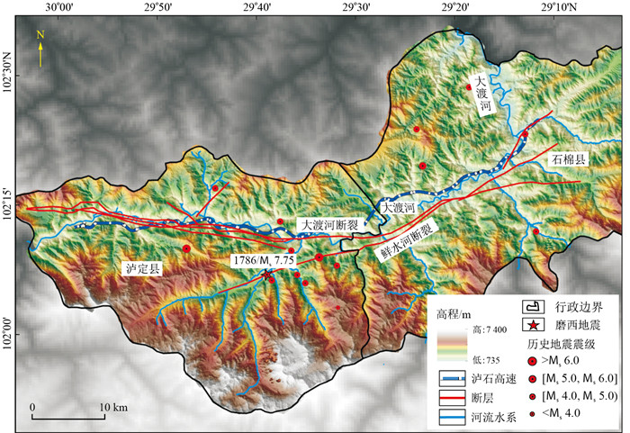
The fault structure along the Lu (ding) Shi (main) highway has developed, and earthquakes are frequent, resulting in a large number and large scale of historical earthquake-induced landslides in the region. However, a large amount of vegetation grows on the surface of these seismic landslides, and it is difficult for traditional surveys to efficiently identify the distribution location and development law of earthquake landslides.
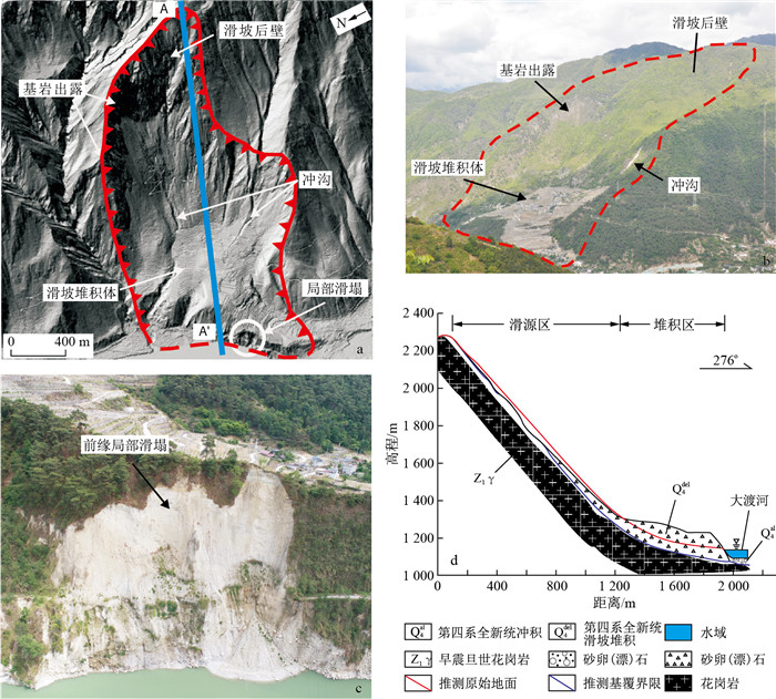
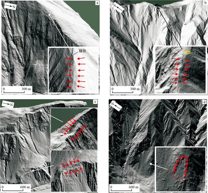
To reduce the safety hazards caused by earthquake landslides during highway construction, this paper first identifies earthquake landslides with high-precision airborne LiDAR data and verifies the accuracy of identification through field review.Second, high-precision airborne LiDAR images are used to analyse the deformation characteristics of seismic landslides.Finally, the spatial distribution characteristics of the seismic landslides are analysed by comprehensively considering the three major factors (6 factors) of topography, geology and earthquakes.
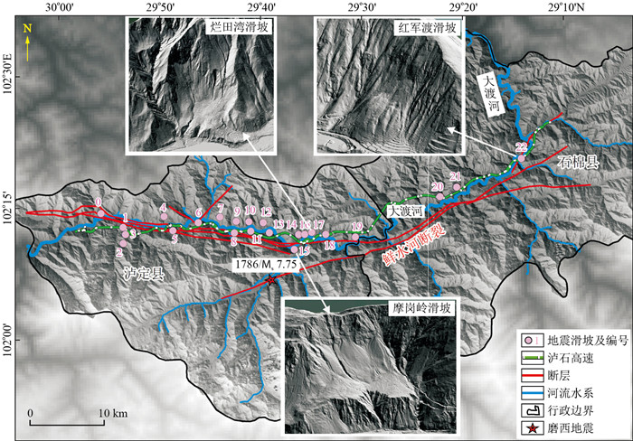
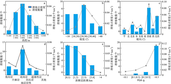
The results show that airborne LiDAR technology can be used to effectively detect seismic landslides under vegetation layers. A total of 23 seismic landslides are identified along the Lushi Expressway Common Road, and the accuracy of field review and verification is 100%.By analysing the six factors controlling the spatial distribution of seismic landslides, it is concluded that the correlations with fault structure and earthquakes are the highest.
The research results provide a reference for landslide identification and investigations of expressways with dense vegetation and provide data support for landslide disaster prevention and risk assessment of the Lushi Expressway.

| [1] |
吴俊峰. 大渡河流域重大地震滑坡发育特征与成因机理研究[D]. 成都: 成都理工大学, 2013.
WU J F. Study on the development characteristics and genetic mechanism of major earthquake landslides in Dadu River Basin[D]Chengdu: Chengdu University of Technology, 2013. (in Chinese with English abstract)
|
| [2] |
许冲, 徐锡伟. 基于GIS与ANN模型的地震滑坡易发性区划[J]. 地质科技情报, 2012, 31(3): 116-121. https://www.cnki.com.cn/Article/CJFDTOTAL-DZKQ201203019.htm
XU C, XU X W. Seismic landslide susceptibility zoning based on GIS and ANN model[J]Geological Science and Technology Information, 2012, 31(3): 116-121. (in Chinese with English abstract) https://www.cnki.com.cn/Article/CJFDTOTAL-DZKQ201203019.htm
|
| [3] |
郭晨, 许强, 董秀军, 等. 复杂山区地质灾害机载激光雷达识别研究[J]. 武汉大学学报(信息科学版), 2021, 46(10): 1538-1547. https://www.cnki.com.cn/Article/CJFDTOTAL-WHCH202110012.htm
GUO C, XU Q, DONG X J, et al. Study on airborne lidar identification of geological hazards in complex mountainous areas[J]. Journal of Wuhan University(Information Science Edition), 2021, 46(10): 1538-1547. (in Chinese with English abstract) https://www.cnki.com.cn/Article/CJFDTOTAL-WHCH202110012.htm
|
| [4] |
许强, 董秀军, 李为乐. 基于天-空-地一体化的重大地质灾害隐患早期识别与监测预警[J]. 武汉大学学报(信息科学版), 2019, 44(7): 957-966. https://www.cnki.com.cn/Article/CJFDTOTAL-WHCH201907002.htm
XU Q, DONG X J, LI W L. Early identification, monitoring and early warning of major geological hazards based on the integration of space, space and earth[J]. Journal of Wuhan University(Information Science Edition), 2019, 44(7): 957-966. (in Chinese with English abstract) https://www.cnki.com.cn/Article/CJFDTOTAL-WHCH201907002.htm
|
| [5] |
NICHOL J, WONG M S. Detection and interpretation of landslides using satellite images[J]. Land Degradation & Development, 2005, 16(3): 243-255.
|
| [6] |
THOTA S, SWAKANGKHA G, MAYAK J. Correction to: Exploitation of optical and SAR amplitude imagery for landslide identification: A case study from Sikkim, northeast India. [J]. Environmental Monitoring and Assessment, 2021, 193(8).
|
| [7] |
SCHLÖGEL R, DOUBRE C, MALET J P, et al. Landslide deformation monitoring with ALOS/PALSAR imagery: A D-InSAR geomorphological interpretation method[J]. Geomorphology, 2015, 231: 314-330. doi: 10.1016/j.geomorph.2014.11.031
|
| [8] |
吴琪, 周创兵, 黄发明, 等. 基于双重注意力机制的滑坡识别方法优化[J]. 地质科技通报, 2022, 41(2): 246-253. doi: 10.19509/j.cnki.dzkq.2022.0053
WU Q, ZHOU C B, HUANG F M, et al. Optimization of landslide identification method based on dual attention mechanism[J]. Bulletin of Geological Science and Technology, 2022, 41(2): 246-253. (in Chinese with English abstract) doi: 10.19509/j.cnki.dzkq.2022.0053
|
| [9] |
董秀军, 王栋, 冯涛. 无人机数字摄影测量技术在滑坡灾害调查中的应用研究[J]. 地质灾害与环境保护, 2019, 30(3): 77-84. https://www.cnki.com.cn/Article/CJFDTOTAL-DZHB201903014.htm
DONG X J, WANG D, FENG T. Application of UAV digital photogrammetry technology in landslide hazard investigation[J]. Geological Hazards and Environmental Protection, 2019, 30(3): 77-84. (in Chinese with English abstract) https://www.cnki.com.cn/Article/CJFDTOTAL-DZHB201903014.htm
|
| [10] |
LINDNER G, SCHRAML K, MANSBERGER R, et al. UAV monitoring and documentation of a large landslide[J]. Appl Geomat, 2016, 8: 1-11. doi: 10.1007/s12518-015-0165-0
|
| [11] |
ROSSI G, TANTERI L, TOFANI V, et al. Multitemporal UAV surveys for landslide mapping and characterization[J]. Landslides, 2018, 15(5): 1045-1052. doi: 10.1007/s10346-018-0978-0
|
| [12] |
VALKANIOTIS S, PAPATHANASSIOU G, GANAS A. Mapping an earthquake-induced landslide based on UAV imagery: Case study of the 2015 Okeanos landslide, Lefkada, Greece[J]. Engineering Geology, 2018, 245: 141-152. doi: 10.1016/j.enggeo.2018.08.010
|
| [13] |
董秀军, 许强, 佘金星, 等. 九寨沟核心景区多源遥感数据地质灾害解译初探[J]. 武汉大学学报(信息科学版), 2020, 45(3): 432-441. https://www.cnki.com.cn/Article/CJFDTOTAL-WHCH202003015.htm
DONG X J, XU Q, SHE J X, et al. Preliminary study on interpretation of geological hazards from multi-source remote sensing data in Jiuzhaigou core scenic area[J]. Journal of Wuhan University(Information Science Edition), 2020, 45(3): 432-441. (in Chinese with English abstract) https://www.cnki.com.cn/Article/CJFDTOTAL-WHCH202003015.htm
|
| [14] |
SCHULZ W H. Landslide susceptibility revealed by LiDAR imagery and historical records, Seattle, Washington[J]. Engineering Geology, 89(1/2): 67-87.
|
| [15] |
WENL, FUMIO Y, YOSHIHISA M. Detection of earthquake-induced landslides during the 2018 Kumamoto Earthquake using multitemporal airborne lidar data[J]. Remote Sensing, 2019, 11(19): 2292. doi: 10.3390/rs11192292
|
| [16] |
王敏杰, 李天斌, 孟陆波, 等. 四川″Y字形″断裂交汇部应力场反演分析[J]. 铁道科学与工程学报, 2015, 12(5): 1088-1095. https://www.cnki.com.cn/Article/CJFDTOTAL-CSTD201505016.htm
WANG M J, LI T B, MENG L B, et al. Inversion analysis of stress field at the intersection of "Y-shaped" fault in Sichuan[J]. Journal of Railway Science and Engineering, 2015, 12(5): 1088-1095. (in Chinese with English abstract) https://www.cnki.com.cn/Article/CJFDTOTAL-CSTD201505016.htm
|
| [17] |
王欣, 方成勇, 唐小川, 等. 泸定Ms 6.8级地震诱发滑坡应急评价研究[J/OL]. 武汉大学学报(信息科学版): 1-15[2022-12-02]. DOI:
WANG X, FANG C Y, TANG X C, et al. Study on emergency assessment of landslide induced by Luding Ms 6.8 earthquake[J/OL]. Journal of Wuhan University(Information Science Edition): 1-15[2022-12-02]. DOI:
|
| [18] |
周荣军, 赖敏, 李大虎, 等. 2011年4月10日四川炉霍Ms5.3级地震强震记录与震害特点[J]. 成都理工大学学报(自然科学版), 2013, 40(2): 217-224. https://www.cnki.com.cn/Article/CJFDTOTAL-CDLG201302014.htm
ZHOU R J, LAI M, LI D H, et al. Strong earthquake records and damage characteristics of the Sichuan Luhuo Ms 5.3 earthquake on April 10, 2011[J]. Journal of Chengdu University of Technology(Natural Science Edition), 2013, 40(2): 217-224. (in Chinese with English abstract) https://www.cnki.com.cn/Article/CJFDTOTAL-CDLG201302014.htm
|
| [19] |
庞鑫, 袁明, 卢渊, 等. 基于无人机LiDAR仿地飞行技术的高陡边坡危岩体快速识别方法[J]. 地质科技通报, 2023, 42(6): 21-30. doi: 10.19509/j.cnki.dzkq.tb20220427
LONG X, YUAN M, LU Y, et al. A rapid identification method for high and steep slope dangerous rock body based on drone LiDAR geomorphic flight technology[J]. Bulletin of Geological Science and Technology, 2023, 42(6): 21-30. (in Chinese with English abstract) doi: 10.19509/j.cnki.dzkq.tb20220427
|
| [20] |
郭晓光. 大渡河流域石棉-泸定段大型古滑坡与河谷侵蚀的孕生关系[D]. 成都: 成都理工大学, 2015.
GUO X G. The relationship between large-scale ancient landslides and valley erosion in the Shimian Luding section of the Dadu River Basin[D]. Chengdu: Chengdu University of Technology, 2015. (in Chinese with English abstract)
|
| [21] |
赵波. 川西北高烈度峡谷区大型地震滑坡成因机制研究[D]. 成都: 成都理工大学, 2019.
ZHAO B. Research on the genesis mechanism of large-scale earthquake landslides in high-intensity canyon areas of northwest Sichuan[D]. Chengdu: Chengdu University of Technology, 2019. (in Chinese with English abstract)
|
| [22] |
庄建琦, 崔鹏, 葛永刚, 等. 5.12汶川地震崩塌滑坡分布特征及影响因子评价: 以都江堰至汶川公路沿线为例[J]. 地质科技情报, 2009, 28(2): 16-22. https://www.cnki.com.cn/Article/CJFDTOTAL-DZKQ200902003.htm
ZHUANG J Q, CUI P, GE Y G, et al. 5.12 Evaluation of the distribution characteristics and impact factors of landslides in the Wenchuan earthquake: Taking the Dujiangyan Wenchuan highway as an example[J]. Geological Science and Technology Information, 2009, 28(2): 16-22. (in Chinese with English abstract) https://www.cnki.com.cn/Article/CJFDTOTAL-DZKQ200902003.htm
|
Copyright © 2010Editorial Department of Bulletin of Geological Science and Technology
Supported by:
Beijing Renhe Information Technology Co., Ltd.


 DownLoad: