| Citation: | Wang Jing, Xu Yadong, Lin Xiao, Peng Shaoyong, Shi Yuanrun, Zhu Yunhai. Analysis on difference of erosion capacity and river capture prediction in the head of the Xiangjiang tributary constrainted by surface and deep geological information[J]. Bulletin of Geological Science and Technology, 2022, 41(4): 234-240. doi: 10.19509/j.cnki.dzkq.2022.0127

|
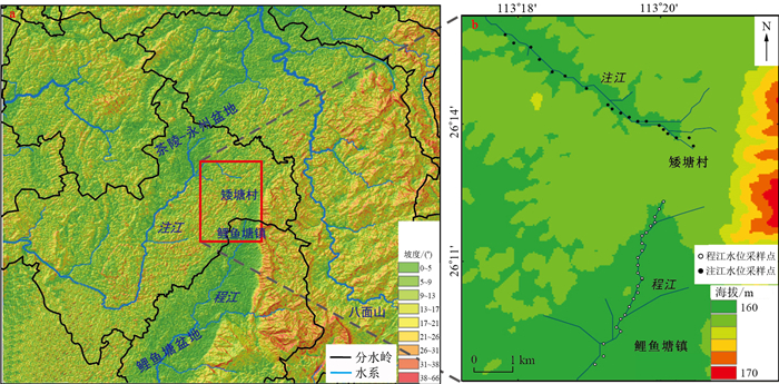
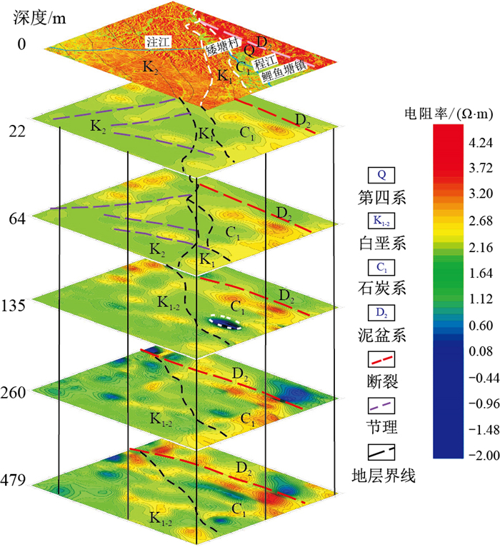
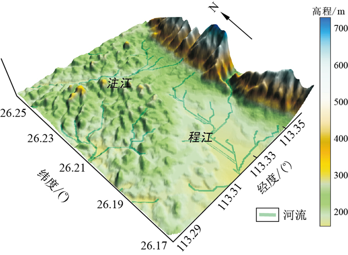
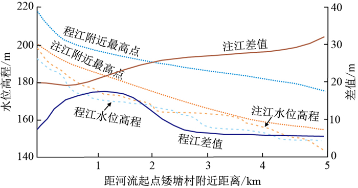
Based on the comprehensive method of basic surface geological investigation, GIS watershed analysis and deep geophysical analysis, the difference in retrogressive erosion along the Xiangjiang tributary is compared. Two drainage areas in the head of the Xiangjiang tributary, the Chengjiang and Zhujiang Rivers, are selected as subjects with the same source of erosion at Aitang Village. Under comparison with topography, water level elevation, lithology of bedrock strata, tectonic setting and deep geophysical data, the Zhujiang River has greater erosion ability and stronger headward erosion, with easily eroded bedrock and well-developed joints. It is predicted that river capture could occur around Aitang village. The evolution trend may lead to a decrease in water volume of Liyu town in the lower reaches of the Chengjiang River, which will affect urban domestic water and industrial and agricultural production. In addition, the continuous strengthening of retrogressive erosion can cause downcutting erosion of the Cretaceous red layer and the watershed will present a more spectacular Danxia landscape.

| [1] |
Beaumont C, Fullsack P, Hamilton J. Erosional control of active compressional orogens[J]. Thrust Tectonics, 1992, 32(4): 1-18.
|
| [2] |
Willett S, Beaumont C, Fullsack P. Mechanical model for the tectonics of doubly vergent compressional orogens[J]. Geology, 1993, 21(4): 371-374. doi: 10.1130/0091-7613(1993)021<0371:MMFTTO>2.3.CO;2
|
| [3] |
Beaumont C, Jamieson R A, Nguyen M H, et al. Himalayan tectonics explained by extrusion of a low-viscosity crustal channel coupled to focused surface denudation[J]. Nature, 2001, 414(6865): 738-742. doi: 10.1038/414738a
|
| [4] |
Zeitler P K, Koons P O, Bishop M P, et al. Crustal reworking at Nanga Parbat, Pakistan: Metamorphic consequences of thermal-mechanical coupling facilitated by erosion[J]. Tectonics, 2001, 20(5): 712-728. doi: 10.1029/2000TC001243
|
| [5] |
Robl J, Stuewe K, Hergarten S. Channel profiles around Himalayan river anticlines: Constraints on their formation from digital elevation model analysis[J]. Tectonics, 2008, 27(3): 1-19.
|
| [6] |
Whittaker A C. How do landscapes record tectonics andclimate?[J]. Lithosphere, 2012, 4(2): 160-164. doi: 10.1130/RF.L003.1
|
| [7] |
Beranek L P, Link P K, Fanning C M. Miocene to Holocene landscape evolution of the western Snake River Plain region, Idaho: Using the SHRIMP detrital zircon provenance record to track eastward migration of the Yellowstone hotspot[J]. Geological Society of America Bulletin, 2006, 118(9/10): 1027-1050.
|
| [8] |
Prince P S, Spotila J A, Henika W S. Stream capture as driver of transient landscape evolution in a tectonically quiescent setting[J]. Geology, 2011, 39(9): 823-826. doi: 10.1130/G32008.1
|
| [9] |
Vella P, Neef G, Kaewyana W. River piracy at Kakariki, north-western Wairarapa, New Zealand[J]. Journal of the Royal Society of New Zealand, 2012, 17(4): 373-380.
|
| [10] |
Willett S D, Mccoy S W, Perron J T, et al. Dynamic Reorganization of River Basins[J]. Science, 1987, 343 (6175): 1248765.
|
| [11] |
Shugar D H, Clague J J, Best J L, et al. River piracy and drainage basin reorganization led by climate-driven glacier retreat. [J]. Nature Geoscience, 2017, 10(5): 370-375. doi: 10.1038/ngeo2932
|
| [12] |
Lucchitta I. Late cenozoic uplift of the southwestern colorado plateau and adjacent lower colorado river region[J]. Tectonophysics, 1979, 61(1/3): 63-95.
|
| [13] |
Petit C, Campy M, Chaline J, et al. Major palaeohydrographic changes in Alpine foreland during the Pliocene-Pleistocene[J]. Boreas, 2010, 25(2): 131-143.
|
| [14] |
Ziegler P A, Fraefel M. Response of drainage systems to Neogene evolution of the Jura fold-thrust belt and Upper Rhine Graben[J]. Swiss Journal of Geoscience, 2009, 102(1): 57-75. doi: 10.1007/s00015-009-1306-4
|
| [15] |
Craddock W H, Kirby E, Harkins N W, et al. Rapid fluvial incision along the Yellow River during headward basin integration[J]. Nature Geoscience, 2010, 3(3): 209-213. doi: 10.1038/ngeo777
|
| [16] |
Clark M K, Schoenbohm L M, Royden L H, et al. Surface uplift tectonics, and erosion of eastern Tibet from large-scale drainage patterns[J]. Tectonics, 2004, 23(1): 1-20.
|
| [17] |
Clift P D, Blusztajn J. Reorganization of the western Himalayan river system after five million years ago. [J]. Nature, 2005, 438(7070): 1001-1003. doi: 10.1038/nature04379
|
| [18] |
Thomas D, David S G, Shaw P A. Late Cainozoic drainage evolution in thezambezi basin: Geomorphological evidence from the kalahari rim[J]. Journal of African Earth Sciences, 1988, 7(4): 611-618. doi: 10.1016/0899-5362(88)90111-X
|
| [19] |
郭福生, 陈留勤, 严兆彬, 等. 丹霞地貌定义、分类及丹霞作用研究[J]. 地质学报, 2020, 94(2): 361-374. doi: 10.3969/j.issn.0001-5717.2020.02.002
Guo F S, Chen L Q, Yan Z B. Definition, classification, and danxianization of Danxia landscapes[J]. Acta Geologica Sinica, 2020, 94(2): 361-374(in Chinese with English abstract). doi: 10.3969/j.issn.0001-5717.2020.02.002
|
| [20] |
李佩贤, 程政武, 张志军, 等. 广东南雄盆地的"南雄层"和"丹霞层"[J]. 地球学报, 2007, 28(2): 181-189. doi: 10.3321/j.issn:1006-3021.2007.02.008
Li P X, Cheng Z W, Zhang Z J, et al. TheNanxiong Bed and the Danxia Bed in the Nanxiong Basin of Guangdong Province[J]. Acta Geoscientica Sinica, 2007, 28(2): 181-189(in Chinese with English abstract). doi: 10.3321/j.issn:1006-3021.2007.02.008
|
| [21] |
章桂芳, 陈凯伦, 张浩然, 等. 基于DEM的丹霞地貌演化阶段划分[J]. 中山大学学报: 自然科学版, 2018, 57(2): 12-21. https://www.cnki.com.cn/Article/CJFDTOTAL-ZSDZ201802002.htm
Zhang G F, Chen K L, Zhang H R, et al. The evolution stage decision of Danxia landform based on digital elevation model (DEM)[J]. Acta Scientiarum: Natralium Universitatis Sunyatseni, 2018, 57(2): 12-21(in Chinese with English abstract). https://www.cnki.com.cn/Article/CJFDTOTAL-ZSDZ201802002.htm
|
| [22] |
姜鲁光, 张祖陆. 山东沂源河流袭夺的初步研究[J]. 曲阜师范大学学报: 自然科学版, 2003, 29(1): 105-108. doi: 10.3969/j.issn.1001-5337.2003.01.028
Jiang L G, Zhang Z L. A preliminary study on the river capture in Yiyuan county[J]. Journal of Qufu Normal University: Natural Science, 2003, 29(1): 105-108(in Chinese with English abstract). doi: 10.3969/j.issn.1001-5337.2003.01.028
|
| [23] |
于洋, 王先彦, 李一泉, 等. 长江源地区通天河段水系格局演化与构造活动的关系[J]. 地理学报, 2018, 73(7): 1338-1351. https://www.cnki.com.cn/Article/CJFDTOTAL-DLXB201807013.htm
Yu Y, Wang X Y, Li Y Q, et al. The evolution of drainage pattern and its relation to tectonic movement in the upstream Yangtze catchment[J]. Acta Geographica Sinica, 2018, 73(7): 1338-1351(in Chinese with English abstract). https://www.cnki.com.cn/Article/CJFDTOTAL-DLXB201807013.htm
|
| [24] |
Ma Z, Zhang H, Wang Y, et al. Inversion of Dadu River Bedrock Channels for the Late Cenozoic Uplift History of the Eastern Tibetan Plateau[J]. Geophysical Research Letters, 2020, 47(4): 1-9.
|
| [25] |
沈鹏飞. 南雄-丹霞盆地白垩纪沉积序列演化特征及其对南海构造转换的响应[D]. 北京: 中国地质大学(北京), 2014.
Shen P F. The evolution mirrored by the Cretaceous sedimentary sequences in the Nanxiong-Danxia Basin and its response to the tectonic transition at the SCS's area[D]. Beijing: China University of Geosciences(Beijing), 2014(in Chinese with English abstract).
|
| [26] |
赵卿宇, 肖国桥, 李辉. 黄河源地区的河谷地貌特征及其对黄河上游形成和演化的启示[J]. 第四纪研究, 2019, 39(2): 339-349.
Zhao Q Y, Xiao G Q, Li H. Valley features of the Yellow River source area and its implications for the formation and evolution of the upstream[J]. Quaternary Sciences, 2019, 39(2): 339-349(in Chinese with English abstract).
|
| [27] |
胡小猛, 陈敏, 王杜涛. 浙江常山"国家地质公园"芙蓉峡段河谷地貌袭夺事件分析[J]. 地理与地理信息科学, 2008, 24(4): 66-69. https://www.cnki.com.cn/Article/CJFDTOTAL-DLGT200804017.htm
Hu X M, Chen M, Wang D T. Study on the River Piracy in Furong Gorge Section in Changshan National Geopark, Zhejiang Province[J]. Geography and Geo-Information Science, 2008, 24(4): 66-69(in Chinese with English abstract). https://www.cnki.com.cn/Article/CJFDTOTAL-DLGT200804017.htm
|
| [28] |
陶佳. 基于DEM的庐山河流袭夺演变研究[D]. 南京: 南京师范大学, 2012.
Tao J. Research of Lushan river capture based on DEM[D]. Nanjing: Nanjing Normal University, 2012(in Chinese with English abstract).
|
| [29] |
Menier D, Mathew M, Pubellier M, et al. Landscape response to progressive tectonic and climatic forcing in NW Borneo: Implications for geological and geomorphic controls on flood hazard[J]. Scientific Reports, 2017, 7(1): 455-485. doi: 10.1038/s41598-017-00557-2
|
| [30] |
李正晨, 王先彦, 于洋, 等. 岩性和侵蚀基准面对构造活跃区河流地貌演化的影响: 以青藏高原东北缘老虎山和哈思山地区为例[J]. 中国科学: 地球科学, 2021, 51(6): 994-1008. https://www.cnki.com.cn/Article/CJFDTOTAL-JDXK202106011.htm
Li Z C, Wang X Y, Yu Y, et al. The impacts of base level and lithology on fluvial geomorphic evolution at the tectonically active Laohu and Hasi Mountains, northeastern Tibetan Plateau[J]. Science China: Earth Sciences, 2021, 64(6): 994-1008 (in Chinese with English abstract). https://www.cnki.com.cn/Article/CJFDTOTAL-JDXK202106011.htm
|
| [31] |
甘泉. 远源细粒辫状河心滩坝演化与河流分叉的交互沉积过程: 现代沉积启示与数值模拟分析[J]. 地质科技通报, 2021, 40(1): 14-26. doi: 10.19509/j.cnki.dzkq.2021.0101
Gan Q. Interaction and sedimentary process between the evolution of the bar and bifurcation of the river in the far-source fine-grained braided river: Numerical simulation analysis inspired by modern deposition[J]. Bulletin of Geological Science and Technology, 2021, 40(1): 14-26(in Chinese with English abstract). doi: 10.19509/j.cnki.dzkq.2021.0101
|
| [32] |
Zhu C, Wu L, Zhu T X, et al. Experimental studies on the Danxia landscape morphogenesis in Mt. Danxiashan, South China[J]. Journal of Geographical Sciences, 2015, 25(8): 943-966. doi: 10.1007/s11442-015-1212-9
|
| [33] |
刘鑫, 郭福生, 陈留勤, 等. 红层盆地岩性差异对丹霞地貌发育的控制[J]. 山地学报, 2019, 37(2): 214-221. https://www.cnki.com.cn/Article/CJFDTOTAL-SDYA201902007.htm
Liu X, Guo F S, Chen L Q, et al. Lithologic control on the development of danxia landscapes in Red Basins[J]. Mountain Research, 2019, 37(2): 214-221(in Chinese with English abstract). https://www.cnki.com.cn/Article/CJFDTOTAL-SDYA201902007.htm
|
| [34] |
史元润, 林晓, 徐亚东, 等. 南岭及邻区第四纪地层分区与综合地层格架[J]. 地质科技通报, 2021, 40(3): 151-162. doi: 10.19509/j.cnki.dzkq.2021.0309
Shi Y R, Lin X, Xu Y D, et al. Quaternary stratigraphic regionalization and comprehensive framework in Nanling and adjacent areas[J]. Bulletin of Geological Science and Technology, 2021, 40(3): 151-162(in Chinese with English abstract). doi: 10.19509/j.cnki.dzkq.2021.0309
|
Copyright © 2010Editorial Department of Bulletin of Geological Science and Technology
Supported by:
Beijing Renhe Information Technology Co., Ltd.


 DownLoad: