


Model tests of the vertical ground deformation measurement of landslide based on multiple UAV images and its application
-
摘要:
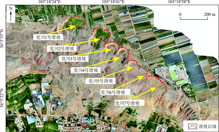
滑坡地质灾害严重威胁人民生命财产安全,滑坡地表竖向变形测量属于滑坡监测与预警的重要组成部分。近年来,国内外学者开始尝试使用多期无人机影像开展滑坡地表变形监测,然而基于多期无人机影像的滑坡地表竖向变形测量精度研究却相对较少。首先通过大量室外模型试验,对CloudCompare、Global Mapper和PolyWorks三款软件地表竖向变形识别的结果进行了对比和研究;在此基础上,定量分析了三款软件地表竖向变形测量的精度。研究结果表明:当无人机影像分辨率优于3.0cm/像素,三款软件均能识别5.0cm及以上的地表竖向变形;在不同地表竖向变形工况下,Global Mapper地表竖向变形测量结果最为精确与稳定,竖向变形测量的中误差总体上分布于1.5~4.0 cm之间。三款软件地表竖向变形测量的中误差和测量误差的均值及标准差均与地表竖向变形值不呈现明显相关性,同时地表竖向变形量测误差均近似满足正态分布,因此可选取测量误差的95%置信区间对地表竖向变形测量结果进行修正。在此基础之上,运用Global Mapper软件开展了黑方台党川段滑坡地表竖向变形识别与测量应用,结果表明Global Mapper软件能较为准确地识别出滑坡变形区域并圈定其位置。
Abstract:The safety of people and property in mountainous regions can be affected by landslides, and measurement of vertical ground formation is a vital component of landslide monitoring and forecasting. Over the past few years, UAV images have gained increasing popularity in the landslide monitoring; however, studies on the measurement accuracy of UAV image-based landslide surface deformation monitoring are relatively limited. In this study, a series of outdoor model tests are conducted to investigate the measurement accuracy of the digital difference-based software of CloudCompare, Global Mapper, and PolyWorks in UAV image-based vertical ground deformation measurement. The results indicate that when the resolution of the input UAV image is better than 3.0 cm/pixel, all the selected software can recognize the ground deformation zones with vertical ground deformation larger than 5.0 cm; under different vertical ground deformation scenarios, the vertical ground deformation measurement obtained with Global Mapper tends to be more accurate, and the medium error of the measurement ranges from 1.5 cm to 4.0 cm. Neither the medium error of measurement nor the standard deviation of measurement error is greatly affected by the magnitude of vertical ground deformation. The statistical analysis of measurement error suggests that the measurement errors of the selected software all follow normal distributions; then, based on the statistics of the measurement errors, the 95% confidence intervals of the vertical ground deformations obtained from the selected software could be obtained. Furthermore, Global Mapper software is applied to identify and measure the vertical deformation of the Dangchuan landslides in Heifangtai, and the results indicate that this software can accurately identify the landslide deformation area and locate the related ranges.
-
Key words:
- landslide /
- vertical ground deformation /
- UAV images /
- model test /
- digital difference
-

图 1 滑坡地表竖向变形测量原理图
Figure 1. Schematic diagram of the vertical ground deformation measurement of the landslide surface

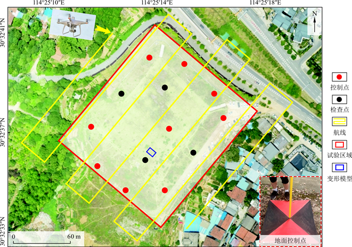
图 3 试验区域无人机航测航线规划与地面控制点布设方案
Figure 3. Design of flight route ground control points in the UAV photogrammetry

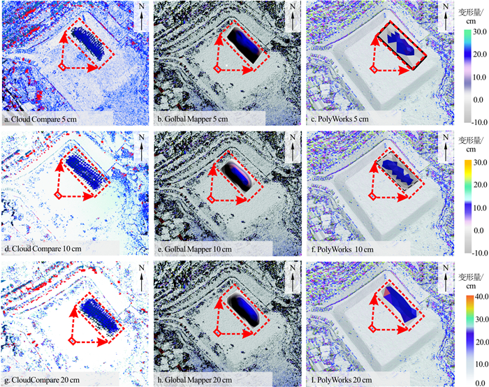
图 4 3款软件地表竖向变形识别结果
Figure 4. Vertical ground deformations of the ground surface obtained from three selected software

图 5 CloudCompare与Global Mapper地表竖向变形区域位置圈定示意图
Figure 5. Schematic diagram of identification of vertical ground deformation zone with CloudCompare and Global Mapper

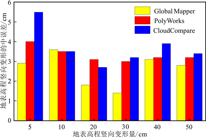
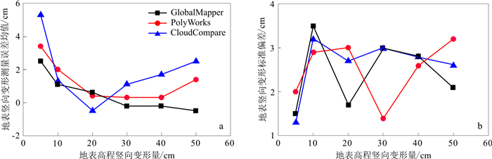
图 6 3款软件各试验工况地表竖向变形测量的中误差
Figure 6. Medium errors in measuring the vertical ground deformation of the 3 selected software

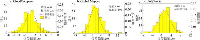
图 7 地表竖向变形为30.0 cm时对应的3款软件测量误差统计直方图
Figure 7. Histograms of the errors in measuring the vertical ground deformation of the 3 selected software with 30.0 cm vertical ground deformation

图 8 3款软件各试验工况地表竖向变形测量误差均值(a)和标准偏差(b)
Figure 8. Statistics of the errors in measuring the vertical ground deformation of the 3 selected software

图 9 3款软件测量误差统计直方图(地表竖向变形值为5.0~50.0 cm)
Figure 9. Histograms of the errors in measuring the vertical ground deformation of the 3 selected software(the vertical ground deformation varies from 5.0 cm to 50.0 cm)

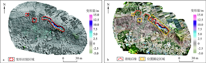
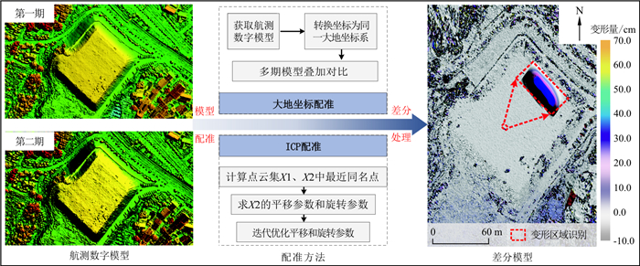
图 11 党川滑坡地表竖向变形识别(a)和变形区域位置圈定结果(b)
Figure 11. Identification of the vertical ground deformation (a) and location of the deformed areas (b) of the Dangchuan landslides
表 1 室外模型试验目标对象参数
Table 1. Parameters setting of the testing objects adopted in the outdoor model test
目标对象 长/cm 宽/cm 高/cm 相对变形量/cm 测量工具 参考目标对象 200.0 50.0 10.0 卷尺测量 变动目标对象1 200.0 50.0 5.0 5.0 变动目标对象2 200.0 50.0 10.0 10.0 变动目标对象3 200.0 50.0 20.0 20.0 变动目标对象4 200.0 50.0 30.0 30.0 变动目标对象5 200.0 50.0 40.0 40.0 变动目标对象6 200.0 50.0 50.0 50.0  下载: 导出CSV
-
[1] 中国地质环境监测院. 全国地质灾害通报(2020)[R]. 北京: 中国地质环境监测院, 2021.China Institute of Geo-Environmental Monitoring. National geological hazard bulletin(2020)[R]. Beijing: China Institute of Geo-Environmental Monitoring, 2021(in Chinese with English abstract). [2] 段钊, 张弘, 唐皓, 等. 泾河下游黄土台塬区侵蚀诱发滑坡机理[J]. 地质科技情报, 2019, 38(6): 10-16. https://www.cnki.com.cn/Article/CJFDTOTAL-DZKQ201906003.htmDuan Z, Zhang H, Tang H, et al. Mechanism of erosion induced landslide in loess plateau area in the lower reaches of Jing River[J]. Geological Science and Technology Information, 2019, 38(6): 10-16(in Chinese with English abstract). https://www.cnki.com.cn/Article/CJFDTOTAL-DZKQ201906003.htm [3] 许冲, 王世元, 徐锡伟, 等. 2017年8月8日四川省九寨沟Ms 7.0地震触发滑坡全景[J]. 地震地质, 2018, 40(1): 232-260. https://www.cnki.com.cn/Article/CJFDTOTAL-DZDZ201801017.htmXu C, Wang S Y, Xu X W, et al. A panorama of landslides triggered by the 8 august 2017 Jiuzhaigou, Sichuan Ms 7.0 earthquake[J]. Seismology and Geology, 2018, 40(1): 232-260(in Chinese with English abstract). https://www.cnki.com.cn/Article/CJFDTOTAL-DZDZ201801017.htm [4] 刘立, 李长安, 高俊华, 等. 基于北斗与InSAR的地质灾害监测关键问题探讨[J]. 地质科技情报, 2019, 38(6): 141-149. https://www.cnki.com.cn/Article/CJFDTOTAL-DZKQ201906017.htmLiu L, Li C A, Gao J H, et al. Geological disaster monitoring combined with BDS and InSAR[J]. Geological Science and Technology Information, 2019, 38(6): 141-149(in Chinese with English abstract). https://www.cnki.com.cn/Article/CJFDTOTAL-DZKQ201906017.htm [5] 张亮, 那晓东, 刘知, 等. 基于国产GF-2卫星影像的遥感地质解译: 以阿吾拉勒地区为例[J]. 地质科技情报, 2018, 37(2): 233-240. https://www.cnki.com.cn/Article/CJFDTOTAL-DZKQ201802032.htmZhang L, Na X D, Liu Z, et al. Remote sensing geological interpretation based on domestic GF-2 satellite imagery: A case study of the Awulale area[J]. Geological Science and Technology Information, 2018, 37(2): 233-240(in Chinese with English abstract). https://www.cnki.com.cn/Article/CJFDTOTAL-DZKQ201802032.htm [6] Du J, Glade T, Woldai T, et al. Landslide susceptibility assessment based on an incomplete landslide inventory in the Jilong Valley, Tibet, Chinese Himalayas[J]. Engineering Geology, 2020, 270: 105572. doi: 10.1016/j.enggeo.2020.105572 [7] Ren T H, Gong W P, Bowa V M, et al. An improved R-index model for terrain visibility analysis for landslide monitoring with InSAR[J]. Remote Sensing, 2021, 13(10): 1938-1938. doi: 10.3390/rs13101938 [8] Zhang Y, Meng X M, Dijkstra T A, et al. Forecasting the magnitude of potential landslides based on InSAR techniques[J]. Remote Sensing of Environment, 2020, 241: 111738. doi: 10.1016/j.rse.2020.111738 [9] 许强, 董秀军, 李为乐. 基于天-空-地一体化的重大地质灾害隐患早期识别与监测预警[J]. 武汉大学学报: 信息科学版, 2019, 44(7): 957-966. https://www.cnki.com.cn/Article/CJFDTOTAL-WHCH201907002.htmXu Q, Dong X J, Li W L. Integrated space-air-ground early detection, monitoring and warning system for potential catastrophic geohazards[J]. Geomatics and Information Science of Wuhan University, 2019, 44(7): 957-966(in Chinese with English abstract). https://www.cnki.com.cn/Article/CJFDTOTAL-WHCH201907002.htm [10] Comert R, Avdan U, Gorum T, et al. Mapping of shallow landslides with object-based image analysis from unmanned aerial vehicle data[J]. Engineering Geology, 2019, 260: 105264. doi: 10.1016/j.enggeo.2019.105264 [11] Samodra G, Ramadhan M F, Sartohadi J, et al. Characterization of displacement and internal structure of landslides from multitemporal UAV and ERT imaging[J]. Landslides, 2020, 17: 2455-2468. doi: 10.1007/s10346-020-01428-0 [12] Cheng Z, Gong W P, Tang H M, et al. UAV photogrammetry-based remote sensing and preliminary assessment of the behavior of a landslide in Guizhou, China[J]. Engineering Geology, 2021, 289: 106172. doi: 10.1016/j.enggeo.2021.106172 [13] Fan X M, Zhan W W, Dong X J, et al. Analyzing successive landslide dam formation by different triggering mechanisms: The case of the Tangjiawan landslide, Sichuan, China[J]. Engineering Geology, 2018, 243: 128-144. doi: 10.1016/j.enggeo.2018.06.016 [14] Gül Y, Hastaoĝlu K, Poyraz F. Using the GNSS method assisted with UAV photogrammetry to monitor and determine deformations of a dump site of three open-pit marble mines in Eliktekke region, Amasya Province, Turkey[J]. Environmental Earth Sciences, 2020, 79(11): 1-20. [15] Rossi G, Tanteri L, Tofani V, et al. Multitemporal UAV surveys for landslide mapping and characterization[J]. Landslides, 2018, 15(5): 1045-1052. doi: 10.1007/s10346-018-0978-0 [16] Valkaniotis S, Papathanassiou G, Ganas A. Mapping an earthquake-induced landslide based on UAV imagery: Case study of the 2015 Okeanos landslide, Lefkada, Greece[J]. Engineering Geology, 2018, 245: 141-152. doi: 10.1016/j.enggeo.2018.08.010 [17] Zhu L, Deng Y, He S M. Characteristics and failure mechanism of the 2018 Yanyuan landslide in Sichuan, China[J]. Landslides, 2019, 16(12): 2433-2444. doi: 10.1007/s10346-019-01262-z [18] 张毅. 基于InSAR技术的地表变形监测与滑坡早期识别研究: 以白龙江流域中游为例[D]. 兰州: 兰州大学, 2018.Zhang Y. Detecting ground deformation and investigating landslides using InSAR technique: Taking middle reach of Bailong River basin as an example[D]. Lanzhou: Lanzhou University, 2018(in Chinese with English abstract). [19] Naseem A, Muhammad S, Luqman H M. Landslide assessment by using multi-temporal UAV datasets: A case study in northern Pakistan[J]. Arabian Journal of Geosciences, 2021, 14(18): 1-9. [20] Darren T, Arko L, Jong S M D. Time series analysis of landslide dynamics using an Unmanned Aerial Vehicle(UAV)[J]. Remote Sensing, 2015, 7(2): 1736-1757. doi: 10.3390/rs70201736 [21] Lucieer A, Jong S M D, Turner D. Mapping landslide displacements using Structure from Motion(SfM) and image correlation of multi-temporal UAV photography[J]. Progress in Physical Geography, 2014, 38(1): 97-116. doi: 10.1177/0309133313515293 [22] Rodriguez J, Macciotta R, Hendry M T, et al. UAVs for monitoring, investigation, and mitigation design of a rock slope with multiple failure mechanisms: A case study[J]. Landslides, 2020, 17(9): 2027-2040. doi: 10.1007/s10346-020-01416-4 [23] Choi S K, Ramirez R A, Kwon T H. Preliminary report of a catastrophic landslide that occurred in Gokseong County, South Jeolla Province, South Korea, on August 7, 2020[J]. Landslides, 2021, 18(4): 1465-1469. doi: 10.1007/s10346-020-01616-y [24] Eker R, Aydınb A. Long-term retrospective investigation of a large, deep-seated, and slow-moving landslide using InSAR time series, historical aerial photographs, and UAV data: The case of Devrek landslide(NW Turkey)[J]. Catena, 2021, 196: 15-58. [25] Hsieh Y C, Chan Y C, Hu J C. Digital elevation model differencing and error estimation from multiple sources: A case study from the Meiyuan Shan landslide in Taiwan[J]. Remote Sensing, 2016, 8(3): 1-20. [26] Mateos R M, Azañón J M, Roldán F J, et al. The combined use of PS InSAR and UAV photogrammetry techniques for the analysis of the kinematics of a coastal landslide affecting an urban area(SE Spain)[J]. Landslides, 2016, 14(2): 743-754. [27] 郭晨, 许强, 彭双麒, 等. 无人机摄影测量技术在金沙江白格滑坡应急抢险中的应用[J]. 灾害学, 2020, 35(1): 203-210. https://www.cnki.com.cn/Article/CJFDTOTAL-ZHXU202001041.htmGuo C, Xu Q, Peng S Q, et al. Application research of UAV photogrammetry technology in the emergency rescue of Baige Landslide[J]. Journal of Catastrophology, 2020, 35(1): 203-210(in Chinese with English abstract). https://www.cnki.com.cn/Article/CJFDTOTAL-ZHXU202001041.htm [28] 巨袁臻. 基于无人机摄影测量技术的黄土滑坡早期识别研究: 以黑方台为例[D]. 成都: 成都理工大学, 2017.Ju Y Z. Early recognition of loess landslide based on UAV photogrammetry: A case study of Heifang terrace[D]. Chengdu: Chengdu University of Technology, 2017(in Chinese with English abstract). [29] Niethammer U, James M R, Rothmund S, et al. UAV-based remote sensing of the Super-Sauze landslide: Evaluation and results[J]. Engineering Geology, 2012, 128: 2-11. doi: 10.1016/j.enggeo.2011.03.012 [30] Ahmad F N, Yusoff A R, Ismail Z, et al. Comparing the performance of point cloud registration methods for landslide monitoring using mobile laser scanning data[J]. International Archives of the Photogrammetry, Remote Sensing and Spatial Information Sciences, 2018, 42(4/W9): 11-21. [31] Stumpf A, Malet J P, Allemand P, et al. Ground-based multi-view photogrammetry for the monitoring of landslide deformation and erosion[J]. Geomorphology, 2015, 231: 130-145. [32] 李德仁, 李明. 无人机遥感系统的研究进展与应用前景[J]. 武汉大学学报: 信息科学版, 2014, 39(5): 505-513, 540. https://www.cnki.com.cn/Article/CJFDTOTAL-WHCH201405001.htmLi D R, Li M. Research advance and application prospect of unmanned aerial vehicle remote sensing system[J]. Geomatics and Information Science of Wuhan University, 2014, 39(5): 505-513, 540(in Chinese with English abstract). https://www.cnki.com.cn/Article/CJFDTOTAL-WHCH201405001.htm [33] 陶于金, 李沛峰. 无人机系统发展与关键技术综述[J]. 航空制造技术, 2014, 464(20): 34-39. https://www.cnki.com.cn/Article/CJFDTOTAL-HKGJ201420010.htmTao Y J, Li P F. Development and key technology of UAV[J]. Aeronautical Manufacturing Technology, 2014, 464(20): 34-39(in Chinese with English abstract). https://www.cnki.com.cn/Article/CJFDTOTAL-HKGJ201420010.htm [34] 万剑华, 王朝, 刘善伟, 等. 倾斜摄影测量构建地质数字露头[J]. 地质科技情报, 2019, 38(1): 258-264. https://www.cnki.com.cn/Article/CJFDTOTAL-DZKQ201901029.htmWan J H, Wang C, Liu S W, et al. Reconsting geological digital outcrops with oblique photogrammetry[J]. Geological Science and Technology Information, 2019, 38(1): 258-264(in Chinese with English abstract). https://www.cnki.com.cn/Article/CJFDTOTAL-DZKQ201901029.htm [35] 朱进, 丁亚洲, 陈攀杰, 等. 控制点布设对无人机影像空三精度的影响[J]. 测绘科学, 2016, 41(5): 116-120. https://www.cnki.com.cn/Article/CJFDTOTAL-CHKD201605026.htmZhu J, Ding Y Z, Chen P J, et al. Influence of control points' layout on aero triangulation accuracy for UAV images[J]. Science of Surveying and Mapping, 2016, 41(5): 116-120(in Chinese with English abstract). https://www.cnki.com.cn/Article/CJFDTOTAL-CHKD201605026.htm [36] 中华人民共和国国家质量监督检验检疫总局, 国家标准化管理委员会. 1∶500、1∶1 000、1∶2 000地形图航空摄影测量内业规范: GB/T7930-2008[S]. 北京: 中国标准出版社, 2008.General Administration of Quality Supervision, Inspection and Quarantine of the People's Republic of China, Standardization Administration. Specifications for aerophotogrammetric office operation of 1∶500, 1∶1 000, 1∶2 000 topographic maps: GB/T7930-2008[S]. Beijing: China Standard of Press, 2008(in Chinese). [37] Cui S H, Pei X J, Wu H Y, et al. Centrifuge model test of an irrigation-induced loess landslide in the Heifangtai loess platform, Northwest China[J]. Journal of Mountain Science, 2018, 15(1): 130-143. [38] 叶伟林, 康丽娟, 安亚鹏, 等. 甘肃永靖焦家村上庄2·28滑坡特点及成因分析[J]. 兰州大学学报: 自然科学版, 2021, 57(3): 369-375, 381. https://www.cnki.com.cn/Article/CJFDTOTAL-LDZK202103012.htmYe W L, Kang L J, An Y P, et al. Analysis of the characteristics and causes of Jiaojia landslide on February 28, 2019 in Yongjing County, Gansu Province[J]. Journal of Lanzhou University: Natural Sciences Edition, 2021, 57(3): 369-375, 381(in Chinese with English abstract). https://www.cnki.com.cn/Article/CJFDTOTAL-LDZK202103012.htm [39] 孔嘉旭, 谷天峰, 孙萍萍, 等. 基于多期无人机影像的黑方台硅化厂滑坡形态变形演化研究[J]. 干旱区资源与环境, 2021, 35(1): 100-107. https://www.cnki.com.cn/Article/CJFDTOTAL-GHZH202101015.htmKong J X, Gu T F, Sun P P, et al. Research on deformation evolution of landslides in Heifangtai silicified plant based on multi-stage UAV images[J]. Journal of Arid Land Resources and Environment, 2021, 35(1): 100-107(in Chinese with English abstract). https://www.cnki.com.cn/Article/CJFDTOTAL-GHZH202101015.htm -

 下载:
下载:


 点击查看大图
计量
- 文章访问数: 492
- PDF下载量: 53
- 被引次数: 0
