


Rapid identification method for the dangerous rock mass of a high-steep slope based on UAV LiDAR and ground imitation flight
-
摘要:
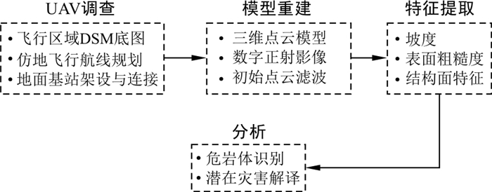
我国西南地区山高谷深、斜坡高陡, 危岩落石灾害极为发育, 高陡边坡危岩落石由于高差大、坡面陡, 具有显著的突发性, 因此快速、准确、便捷地解译与识别危岩体源头成为高陡岩质边坡风险分析的首要问题。当前探测手段的进步使基于影像的地质灾害解译逐步从目视识别向人机交互式识别方向发展。其中, 无人机激光雷达(LiDAR)系统通过融合无人机载体与LiDAR测量技术的优势, 广泛应用于地质灾害调查中, 同时仿地飞行技术的引入可以使无人机LiDAR系统适应复杂的地形, 快速获取高精度、高密度的点云数据。基于以上技术对攀枝花某铁矿露天采场东侧边坡开展了无人机调查, 通过获取高精度DOM影像和三维点云模型, 量化提取点云模型中露头坡面粗糙度、倾向等危岩体几何特征参数作为DOM影像的补充材料, 提出了一套基于DOM影像和几何特征的危岩体人机交互式识别方法。通过对东侧边坡危岩体的应用表明: 提出的人机交互式识别方法通过在DOM影像的基础上叠加露头坡面几何特征, 对悬空危岩体的识别精度优于目视识别, 可以显著提高危岩体识别的效率和准确性。提出的方法通过结合创新的遥感技术, 为高陡岩质边坡危岩体识别提供了快速便捷的方案。
-
关键词:
- 高陡边坡 /
- 危岩体 /
- 无人机LiDAR系统 /
- 仿地飞行 /
- 三维点云模型
Abstract:Objective In Southwest China, rockfall hazards are extremely developed in high mountains and deep valley areas with high and steep slopes. Due to the large elevation difference and steep slope, the dangerous rock mass on a high-steep slope has remarkable characteristics of suddenness. Thus, a rapid, accurate and convenient interpretation and identification for the source of dangerous rock mass becomes the primary problem of risk analysis of high-steep slopes. At present, the progress of detection makes image-based geological hazard interpretation gradually develop from visual identification to human-computer interactive identification. Among them, the UAV LiDAR system is widely used in geological disaster investigation by integrating both advantages of UAV carrier and LiDAR measurement technology, while the introduction of ground imitation flight technology can make the UAV LiDAR system adapt to complex terrain, obtaining high-precision and high-density point cloud data.
Methods On this basis, a UAV survey was carried out on the East side slope of open-pit mine, and a high-precision DOM image and 3D point cloud model were obtained by processing the UAV survey data. As the supplementary materials of the DOM image, the geometric feature parameters of outcrop, including surface roughness and dip, are quantitatively extracted from the point cloud model. On this basis, a set of human-computer interactive identification for dangerous rock masses based on DOM images and geometric features is proposed.
Results The application to the East side slope of open-pit mine shows that by superimposing outcrop slope geometric features based on DOM images, the proposed human-computer interactive identification method can significantly improve the efficiency and accuracy of identification, and the identification of overhanging dangerous rock mass is much more robust than visual ones.
Conclusion By combining innovative remote sensing technologies, the proposed method provides a fast and convenient solution for the identification of dangerous rock masses on high and steep rocky slopes.
-

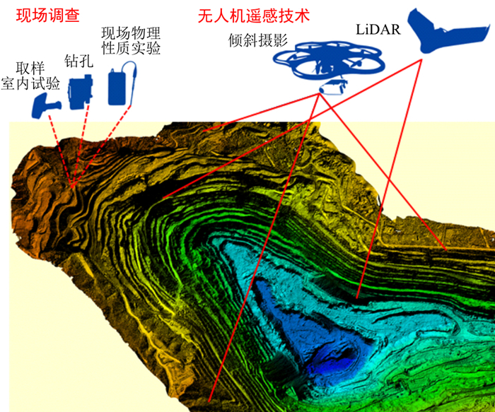
图 1 无人机遥感技术与传统地质勘察手段的结合
Figure 1. Combination of UAV remote sensing technology and traditional geological survey

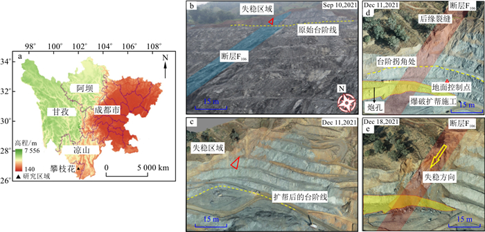
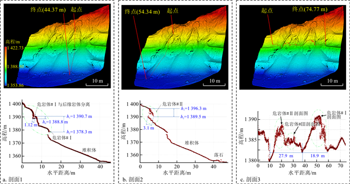
图 4 研究现场的总体情况
a.四川地形图及研究区域位置;b.F106断层;c.失稳前研究区域DOM;d.破坏前影像;e.破坏后影像
Figure 4. Overall situation of the study site

图 5 无人机设备与仿地航线规划
a.DJI M300 RTK搭载AlphaAir 450 LiDAR; b.仿地飞行航线
Figure 5. UAV equipment and route planning of ground imitation flight

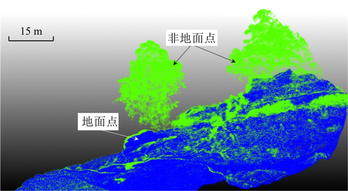
图 6 基于CSF方法的地面点和非地面点分离
Figure 6. Separation of ground and off-ground points based on CSF

图 7 基于DOM和点云透视投影的危岩体初步识别
a.DOM(正视图);b.DOM(侧视图);c.三维点云透视投影(正视图);d.三维点云透视投影(侧视图)
Figure 7. Preliminary recognition of dangerous rock masses based on DOM and perspective projection of point cloud model

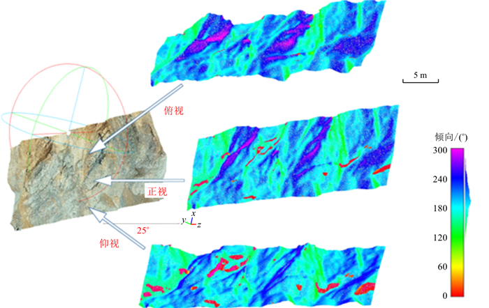
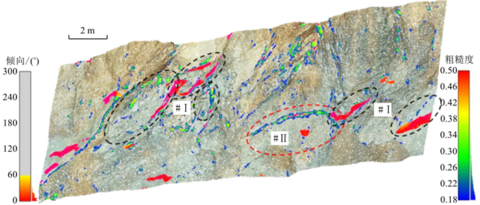
图 13 突出岩体悬空面提取(倾向)
Figure 13. Extraction of the suspended surface of the outburst rock mass

图 14 基于DOM和几何特征参数的人机交互式识别
Figure 14. Human-computer interactive recognition based on DOM image and geometric features
表 1 3类探测手段的对比
Table 1. Comparison of three detection approachs
探测技术 精度 速度 成本 应用范围 UAV激光雷达 非常高/cm 很快 高 大范围/102 km2 UAV摄影测量 较高/cm~m 较快 较高 较大范围/10 km2 遥感卫星 低 很快 较高 全球范围  下载: 导出CSV
表 3 4组结构面产状信息
Table 3. Four sets of discontinuities and their characteristics
点簇 倾向/(°) 倾角/(°) 密度/(个·cm-3) 产状点云占比/% J1 208.384 3 38.734 1 3.289 8 68.46 J2 358.556 0 88.600 1 0.121 1 7.94 J3 10.107 5 86.614 7 0.120 4 7.38 J4 340.624 3 86.044 1 0.095 9 6.15
下载: 导出CSV
-
[1] De Biagi V, Napoli M L, Barbero M, et al. Estimation of the return period of rockfall blocks according to their size[J]. Natural Hazards and Earth System Sciences, 2017, 17(1): 103-113. doi: 10.5194/nhess-17-103-2017 [2] Glade T. Landslide occurrence as a response to land use change: A review of evidence from New Zealand[J]. Catena, 2003, 51(3/4): 297-314. [3] Crosta G B, Agliardi F. Parametric evaluation of 3D dispersion of rockfall trajectories[J]. Natural Hazards and Earth System Sciences, 2004, 4(4): 583-598. doi: 10.5194/nhess-4-583-2004 [4] Michoud C, Derron M H, Horton P, et al. Rockfall hazard and risk assessments along roads at a regional scale: Example in Swiss Alps[J]. Natural Hazards and Earth System Sciences, 2012, 12(3): 615-629. doi: 10.5194/nhess-12-615-2012 [5] Wang X, Frattini P, Crosta G B, et al. Uncertainty assessment in quantitative rockfall risk assessment[J]. Landslides, 2013, 11(4): 711-722. [6] 汤伏全, 芦家欣, 韦书平, 等. 基于无人机LiDAR的榆神矿区采煤沉陷建模方法改进[J]. 煤炭学报, 2020, 45(7): 2655-2666. https://www.cnki.com.cn/Article/CJFDTOTAL-MTXB202007034.htmTang F Q, Lu J X, Wei S P, et al. Improvement of mining subsidence modeling method based on UAV LiDAR in Yushen mining area[J]. Journal of China Coal Society, 2020, 45(7): 2655-2666 (in Chinese with English abstract). https://www.cnki.com.cn/Article/CJFDTOTAL-MTXB202007034.htm [7] 冯威. 高寒高海拔复杂艰险山区无人机勘察技术应用[J]. 铁道工程学报, 2019, 36(8): 9-13. https://www.cnki.com.cn/Article/CJFDTOTAL-TDGC201908003.htmFeng W. Application of unmanned aerial vehicle survey technology in alpine and high altitude complex and difficult mountainous area[J]. Journal of Railway Engineering Society, 2019, 36(8): 9-13 (in Chinese with English abstract). https://www.cnki.com.cn/Article/CJFDTOTAL-TDGC201908003.htm [8] 李杰林, 杨承业, 胡远, 等. 无人机三维激光扫描技术在地下采空区探测中的应用研究[J]. 金属矿山, 2020, 49(12): 168-172.Li J L, Yang C Y, Hu Y, et al. Application research of UAV-LiDAR in detection of underground goaf[J]. Metal Mine, 2020, 49(12): 168-172 (in Chinese with English abstract). [9] 张欢, 巨能攀, 陆渊, 等. 基于无人机的滑坡地形快速重建与稳定性分析[J]. 水文地质工程地质, 2021, 48(6): 171-179. doi: 10.16030/j.cnki.issn.1000-3665.202008010Zhang H, Ju N P, Lu Y, et al. Rapid remodeling of three-dimensional terrain and stability analyses of landslide based on UAV[J]. Hydrogeology & Engineering Geology, 2021, 48(6): 171-179(in Chinese with English abstract). doi: 10.16030/j.cnki.issn.1000-3665.202008010 [10] 殷坤龙, 张宇, 汪洋. 水库滑坡涌浪风险研究现状和灾害链风险管控实践[J]. 地质科技通报, 2022, 41(2): 1-12. doi: 10.19509/j.cnki.dzkq.2022.0064Yin K L, Zhang Y, Wang Y. A review of landslide-generated waves risk and practice of management of hazard chain risk from reservoir landslide[J]. Bulletin of Geological Science and Technology, 2022, 41(2): 1-12 (in Chinese with English abstract). doi: 10.19509/j.cnki.dzkq.2022.0064 [11] 刘圣伟, 郭大海, 陈伟涛, 等. 机载激光雷达技术在长江三峡工程库区滑坡灾害调查和监测中的应用研究[J]. 中国地质, 2012, 39(2): 507-517. https://www.cnki.com.cn/Article/CJFDTOTAL-DIZI201202020.htmLiu S W, Guo D H, Chen W T, et al. The application of airborne LiDAR technology in landslide in vestigation and monitoring of Three Gorges Reservoir area[J]. Geology in China, 2012, 39(2): 507-517 (in Chinese with English abstract). https://www.cnki.com.cn/Article/CJFDTOTAL-DIZI201202020.htm [12] 贾曙光, 金爱兵, 赵怡晴. 无人机摄影测量在高陡边坡地质调查中的应用[J]. 岩土力学, 2018, 39(3): 1130-1136. doi: 10.16285/j.rsm.2017.1474Jia S G, Jin A B, Zhao Y Q. Application of UAV oblique photogrammetry in the field of geology survey at the high and steep slope[J]. Rock and Soil Mechanics, 2018, 39(3): 1130-1136 (in Chinese with English abstract). doi: 10.16285/j.rsm.2017.1474 [13] Fanti R, Gigli G, Lombardi L, et al. Terrestrial laser scanning for rockfall stability analysis in the cultural heritage site of Pitigliano (Italy)[J]. Landslides, 2013, 10(4): 409-420. doi: 10.1007/s10346-012-0329-5 [14] Voge M, Lato M J, Diederichs M S. Automated rockmass discontinuity mapping from 3-dimensional surface data[J]. Engineering Geology, 2013, 164: 155-162. doi: 10.1016/j.enggeo.2013.07.008 [15] Chen J Q, Zhu H H, Li X J. Automatic extraction of discontinuity orientation from rock mass surface 3D point cloud[J]. Computers & Geosciences, 2016, 95: 18-31. [16] Dewez T J B, Girardeau-Montaut D, Allanic C, et al. Facets: A cloudcompare plugin to extract geological planes from unstructured 3D point clouds[J]. XXⅢ ISPRS Congress, 2016, 41(B5): 799-804. [17] Gomes R K, de Oliveira L P L, Gonzaga L, et al. An algorithm for automatic detection and orientation estimation of planar structures in LiDAR-scanned outcrops[J]. Computers & Geosciences, 2016, 90: 170-178. [18] Bordehore L J, Riquelme A, Cano M, et al. Comparing manual and remote sensing field discontinuity collection used in kinematic stability assessment of failed rock slopes[J]. International Journal of Rock Mechanics and Mining Sciences, 2017, 97: 24-32. doi: 10.1016/j.ijrmms.2017.06.004 [19] Guo J T, Liu Y H, Wu L X, et al. Ageometry- and texture-based automatic discontinuity trace extraction method for rock mass point cloud[J]. International Journal of Rock Mechanics and Mining Sciences, 2019, 124: 104132. doi: 10.1016/j.ijrmms.2019.104132 [20] Riquelme A J, Abellán A, Tomás R. Discontinuity spacing analysis in rock masses using 3D point clouds[J]. Engineering Geology, 2015, 195: 185-195. doi: 10.1016/j.enggeo.2015.06.009 [21] Riquelme A, Tomás R, Cano M, et al. Automatic mapping of discontinuity persistence on rock masses using 3D point clouds[J]. Rock Mechanics and Rock Engineering, 2018, 51(10): 3005-3028. doi: 10.1007/s00603-018-1519-9 [22] Slob S. Automated rock mass characterisation using 3D terrestrial laser scanning[D]. Dissertation: International Institute for Geo-information Science and Earth Observation, 2010. [23] Sturzenegger M, Stead D, Elmo D. Terrestrial remote sensing-based estimation of mean trace length, trace intensity and block size/shape[J]. Engineering Geology, 2011, 119(3/4): 96-111. [24] Unlusoy D, Suzen M L. A new method for automated estimation of joint roughness coefficient for 2D surface profiles using power spectral density[J]. International Journal of Rock Mechanics and Mining Sciences, 2020, 125: 104156. doi: 10.1016/j.ijrmms.2019.104156 [25] Zhang P, Zhao Q Y, Tannant D D, et al. 3D mapping of discontinuity traces using fusion of point cloud and image data[J]. Bulletin of Engineering Geology and the Environment, 2019, 78(4): 2789-2801. doi: 10.1007/s10064-018-1280-z [26] Albarelli D S N A, Mavrouli O C, Nyktas P. Identification of potential rockfall sources using UAV-derived point cloud[J]. Bulletin of Engineering Geology and the Environment, 2021, 80(8): 6539-6561. doi: 10.1007/s10064-021-02306-2 [27] 贾虎军, 王立娟, 范冬丽. 无人机载LiDAR和倾斜摄影技术在地质灾害隐患早期识别中的应用[J]. 中国地质灾害与防治学报, 2021, 32(2): 60-65.Jia H J, Wang L J, Fan D L. The application of UAV LiDAR and tilt photography in the early identification of geo-hazards[J]. The Chinese Journal of Geological Hazard and Control, 2021, 32(2): 60-65(in Chinese with English abstract). [28] 吕权儒, 曾斌, 孟小军, 等. 基于无人机倾斜摄影技术的崩塌隐患早期识别及影响区划分方法[J]. 地质科技通报, 2021, 40(6): 313-325, 334. doi: 10.19509/j.cnki.dzkq.2021.0631Lv Q R, Zeng B, Meng X J, et al. Early identificaion and influence range division method of collapse hazards based on UAV oblique photography technology[J]. Bulletin of Geological Science and Technology, 2021, 40(6): 313-325, 334(in Chinese with English abstract). doi: 10.19509/j.cnki.dzkq.2021.0631 [29] 陈飞, 崔健, 王郑. 垂起固定翼无人机激光雷达的电力巡检应用[J]. 测绘科学, 2020, 45(12): 77-80, 125.Chen F, Cui J, Wang Z. Application of vertical fixed-wing UAV carrying LiDAR system on powerline inspection[J]. Science of Surveying and Mapping, 2020, 45(12): 77-80, 125(in Chinese with English abstract). [30] 梁峰. 基于遥感技术与深度学习的四川高陡山区典型地质灾害识别[D]. 成都: 成都理工大学, 2021.Liang F. The identification of typical geohazards in Sichuan steep mountainous based on remote sensing technology and deep learning technology[D]. Chengdu: Chengdu University of Technology, 2021 (in Chinese with English abstract). [31] Zhang W M, Qi J B, Wan P, et al. Aneasy-to-use airborne lidar data filtering method based on cloth simulation[J]. Remote Sensing, 2016, 8(6): 501. [32] Riquelme A J, Abellán A, Tomás R, et al. A new approach for semi-automatic rock mass joints recognition from 3D point clouds[J]. Computers & Geosciences, 2014, 68: 38-52. [33] 崔溦, 谢恩发, 张贵科, 等. 利用无人机技术的高陡边坡孤立危岩体识别[J]. 武汉大学学报: 信息科学版, 2021, 46(6): 836-843.Cui W, Xie E F, Zhang G K, et al. Identification of isolated dangerous rock mass in high and steep slope using unmanned aerial vehicle[J]. Geomatics and Information Science of Wuhan University, 2021, 46(6): 836-843(in Chinese with English abstract). [34] Çevik E, Topal T. GIS-based landslide susceptibility mapping for a problematic segment of the natural gas pipeline, Hendek (Turkey)[J]. Environmental Geology, 2003, 44(8): 949-962. [35] McKean J, Roering J. Objective landslide detection and surface morphology mapping using high-resolution airborne laser altimetry[J]. Geomorphology, 2004, 57(3/4): 331-351. -

 下载:
下载:


 点击查看大图
计量
- 文章访问数: 548
- PDF下载量: 86
- 被引次数: 0
