


Experimental analysis of spatial feature detection of the ring geomorphology at the south edge of Lufeng Dinosaur Valley based on UAV imaging point cloud
-
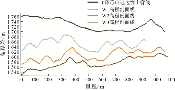
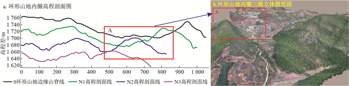
摘要: 为了定量获取复杂地貌构造的特征参数,需要获取高精度、高分辨率的地形地貌数据。在复杂地貌特征探测中,基于无人机航测结合成像点云,可以快速、高效、安全、准确地完成复杂地貌空间探测任务。针对禄丰恐龙谷南缘环状地貌的典型局地场景,采用无人机测量技术获取测区高分辨率的地貌影像数据,构建实景三维场景模型并对其地貌特征进行探测分析研究。试验结果表明:①基于无人机成像点云构建0.2 m分辨率DEM数据能够精准表达研究区真实地貌特征。②通过构建环状场景"内-中-外"7条典型高程剖面线,对比分析证实了研究区地形呈现环形"盆缘"形态特征,内外两侧高程逐渐递减,并且"盆缘"外部剖面高程起伏变化剧烈,地形相较于内部地貌更加复杂。③为进一步探测提取微形地貌特征信息,利用无人机成像原理构建的精准DEM数据结合测区实景三维模型,定量提取了该区坡度、坡向、相对高差、等值线、山脊线、山谷线等相关参数进行精准定量测量及分析探讨。④利用立体三维模型的多视角目视解译与典型场景分析,可清楚辨别出测区冲沟发育以及地质体的节理层理面等微地貌特征。通过以上对地貌三维场景探测试验研究表明,利用实景三维模型能够快速准确呈现测区地貌形态特征,并且成像点云数据综合分析,能够量化、半量化揭示区域构造地质信息。总体而言,无人机测量技术与成像点云3D产品在地质调查中的应用具有实用意义,并具备独特的技术优势。Abstract: In order to quantitatively obtain the characteristic parameters of complex geomorphological structures, high precision and high resolution topographic and geomorphological data are required.In the detection of complex geomorphic features, UAV aerial survey combined with imaging point cloud can accomplish the task of spatial detection of complex geomorphic features quickly, efficiently, safely and accurately.In this study, the UAV measurement technology is used to obtain high-resolution geomorphological image data, construct a realistic 3D scene model and analyse the geomorphological features of the typical local scenes of the ring-shaped landform at the southern edge of Lufeng Dinosaur Valley.The experimental results show that: ①The DSM data obtained based on the UAV imaging point cloud can accurately express the real geomorphological features of the study area by filtering, extracting thinning, classifying and other data processing to obtain the ground points and constructing 0.2 m resolution DEM data by using the progressive encrypted triangle network method.②By constructing 7 typical elevation profiles of the circular scene "inner-middle-outer", the comparative analysis confirms that the topography of the study area is characterized by the 0 profile line as the main highland ridgeline, showing a circular "basin rim" pattern, with gradually decreasing elevation on the inner and outer sides, and the elevation of the outer profile of the "basin rim" changes dramatically, and the topography is more complex than that of the inner landscape.③In order to further detect and extract the information of micro-morphological features, the accurate DEM data constructed by the principle of UAV imaging combined with the realistic 3D model of the survey area, quantitatively extracted the slope, slop direction, relative height difference, contour, ridge line valley line and other related parameters of the area for accurate quantitative measurement and analysis and discussion.④ Using the multi-view visual interpretation of the three-dimensional 3D model and the analysis of typical scenes, micro-geomorphic features such as the development of washouts in the survey area and the nodal laminated surface of the geological body can be clearly identified.Through the above experimental research on geomorphological 3D scene detection, it is easy to find that the use of realistic 3D models can quickly and accurately present the geomorphological features of the survey area, and the comprehensive analysis of imaging point cloud data can quantitatively and semi-quantitatively reveal regional geological structure information.Overall, the UAV measurement technology and imaging point cloud 3D product application in geological survey has practical significance and unique technical advantages.
-
Key words:
- UAV /
- 3D model /
- DSM /
- DEM /
- geomorphological analysis
-

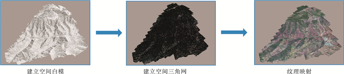
图 5 基于影像数据的多维数字产品构建
Figure 5. Construction of multi-dimensional digital products based on image data

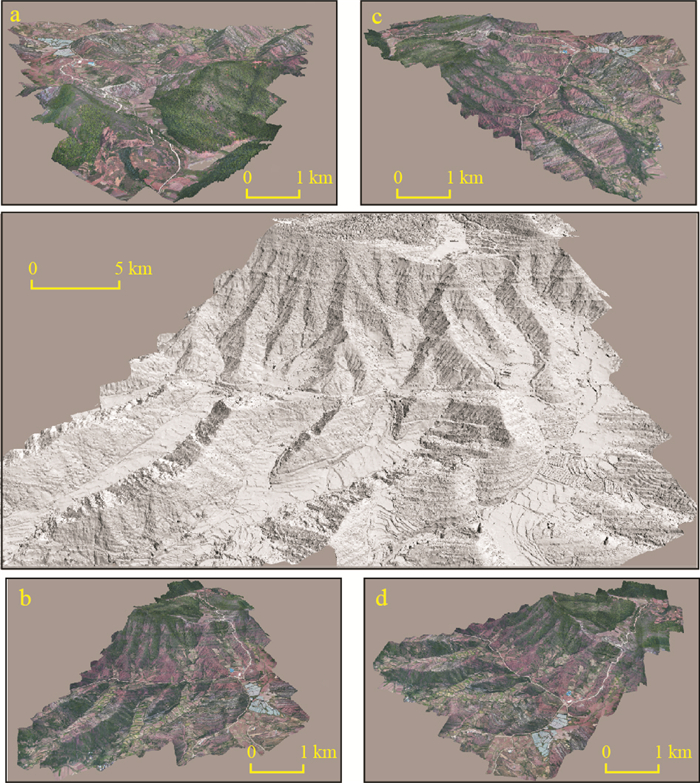
图 9 基于多视角的测区三维模型
a.测区三维模型俯视图; b.测区三维模型仰视图; c.测区三维模型左侧图; d.测区三维模型右侧图
Figure 9. 3d model of survey area based on multiple perspectives

图 10 测区相对高差分布图
Figure 10. Distribution of relative height difference in the survey area

图 11 测区剖面位置示意图
Figure 11. Schematic diagram of the profile position of the survey area

图 13 环形山地边缘外圈高程剖面图与对应三维模型图
Figure 13. Elevation profile of outer ring of ring mountain edge and corresponding 3D model diagram

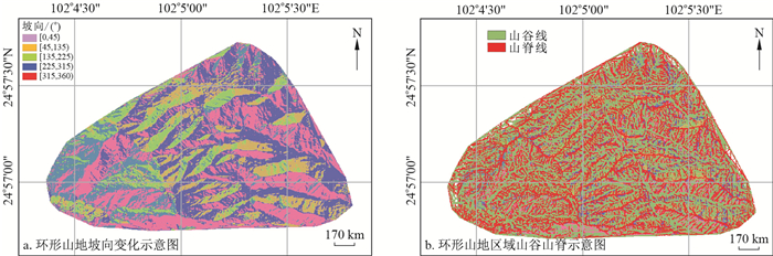
图 15 测区环形山地坡向变化(a)及山谷山脊提取(b)示意图
Figure 15. Schematic diagrams of slope aspect change (a) and extraction of ridge and valley (b) in the survey area
表 1 比例尺精度
Table 1. Scale accuracy
比例尺 1∶500 1∶1 000 1∶2 000 1∶5 000 1∶10 000 比例尺精度 0.05 0.10 0.20 0.50 1.00  下载: 导出CSV
表 2 坡度面积占比统计
Table 2. Statistics of proportion of slope area
坡度等级 1 2 3 4 5 6 7 8 9 合计 坡度/(°) [0, 9) [9, 15) [15, 21) [21, 27) [27, 33) [33, 40) [40, 49) [49, 61) [61, 89] 面积/m2 22 996.76 3 475.49 1 571.04 872.84 568.52 437.76 330.08 219.64 134.84 30 606.97
下载: 导出CSV
表 3 坡向面积占比统计
Table 3. Statistics of slope area proportion
坡向分类 阴坡 半阴坡 阳坡 半阳坡 阴坡 坡向/(°) [0, 45) [45, 135) [135, 225) [225, 315) [315, 360) 面积占比/% 16.5 32 27.5 14 10
下载: 导出CSV
-
[1] 姚林林, 钟果, 李青春, 等. 基于无人机遥感信息的地质解译方法及在地质调查中的综合应用研究[J]. 工程地质学报, 2020, 28(5): 1099-1105. https://www.cnki.com.cn/Article/CJFDTOTAL-GCDZ202005021.htmYao L L, Zhong G, Li Q C, et al. Study on geological interpretation and comprehensive application in the geological investigation based on UAV remote sensing information[J]. Journal of Engineering Geology, 2020, 28(5): 1099-1105(in Chinese with English abstract). https://www.cnki.com.cn/Article/CJFDTOTAL-GCDZ202005021.htm [2] 孔嘉旭, 谷天峰, 孙萍萍, 等. 基于多期无人机影像的黑方台硅化厂滑坡形态变形演化研究[J]. 干旱区资源与环境, 2021, 35(1): 100-107. https://www.cnki.com.cn/Article/CJFDTOTAL-GHZH202101015.htmKong J X, Gu T F, Sun P P, et al. Research on deformation evolution of landslides in Heifangtai Silicified Plan tbased on multi-stage UAV images[J]. Journal of Arid Land Resources and Environment, 2021, 35(1): 100-107(in Chinese with English abstract). https://www.cnki.com.cn/Article/CJFDTOTAL-GHZH202101015.htm [3] 张恺, 伍法权, 沙鹏, 等. 基于无人机倾斜摄影的矿山边坡岩体结构编录方法与工程应用[J]. 工程地质学报, 2019, 27(6): 1448-1455. https://www.cnki.com.cn/Article/CJFDTOTAL-GCDZ201906027.htmZhang K, Wu F Q, Sha P, et al. Geological cataloging method with oblique photography of UAV for open-pit slope and its application[J]. Journal of Engineering Geology, 2019, 27(6): 1448-1455(in Chinese with English abstract). https://www.cnki.com.cn/Article/CJFDTOTAL-GCDZ201906027.htm [4] 彭大雷, 许强, 董秀军, 等. 无人机低空摄影测量在黄土滑坡调查评估中的应用[J]. 地球科学进展, 2017, 32(3): 319-330. https://www.cnki.com.cn/Article/CJFDTOTAL-DXJZ201703008.htmPen D L, Xu Q, Dong X J, et al. Application of unmanned aerial vehicles low-altitude photogrammetry in investigation and evaluationof loess landslide[J]. Advances in Earth Science, 2017, 32(3): 319-330(in Chinese with English abstract). https://www.cnki.com.cn/Article/CJFDTOTAL-DXJZ201703008.htm [5] 李文达, 闫启明, 张尚弘, 等. 基于无人机和SFM的地貌数据采集精度影响研究[J]. 应用基础与工程科学学报, 2019, 27(6): 1225-1234. https://www.cnki.com.cn/Article/CJFDTOTAL-YJGX201906004.htmLi W D, Yan Q M, Zhang S H, et al. Geomorphological data acquisition accuracy based on UAV and SFM[J]. Journal of Basic Science and Engineering, 2019, 27(6): 1225-1234(in Chinese with English abstract). https://www.cnki.com.cn/Article/CJFDTOTAL-YJGX201906004.htm [6] Chen S, Xiang C, Kang Q, et al. Accurate landslide detection leveraging UAV-based aerial remote sensing[J]. IET Communications, 2020, 14(15): 2434-2441. doi: 10.1049/iet-com.2019.1115 [7] Lu C H. Applying UAV and photogrammetry to monitor the morphological changes along the beach in Penghu Islands[R]. Prague, Czech Republic: International Society of Photogrammetry and Remote Sensing, 2016. [8] Jan L, Wiebke M, Christian K, et al. High-resolution classification of south patagonian peat bog microforms reveals potential gaps in up-scaled CH4 fluxes by use of Unmanned Aerial System (UAS) and CIR imagery[J]. Remote Sensing, 2016, 8(3): 173. doi: 10.3390/rs8030173 [9] Tonkin T N, Midgley N G, Graham D J, et al. The potential of small unmanned aircraft systems and structure-from-motion for topographic surveys: A test of emerging integrated approaches at Cwm Idwal, North Wales[J]. Geomorphology, 2014, 226: 35-43. doi: 10.1016/j.geomorph.2014.07.021 [10] Gonalves J A, Henriques R. UAV photogrammetry for topographic monitoring of coastal areas[J]. Isprs Journal of Photogrammetry & Remote Sensing, 2015, 104: 101-111. http://www.onacademic.com/detail/journal_1000037649836910_942e.html [11] Silva O L, Bezerra F H R, Maia R P, et al. Karst landforms revealed at various scales using LiDAR and UAV in semi-arid Brazil: Consideration on karstification processes and methodological constraints[J]. Geomorphology, 2017, 295: 611-630. doi: 10.1016/j.geomorph.2017.07.025 [12] Nichol J E, Shaker A, Wong M S. Application of high-resolution stereo satellite images to detailed landslide hazard assessment[J]. Geomorphology, 2006, 76(1/2): 68-75. http://www.sciencedirect.com/science/article/pii/S0169555X05003223 [13] 连会青, 孟璐, 韩瑞刚, 等. 基于无人机遥感的地质信息提取: 以柳江盆地为例[J]. 国土资源遥感, 2020, 32(3): 136-142. https://www.cnki.com.cn/Article/CJFDTOTAL-GTYG202003019.htmLi H Q, Men L, Han R G, et al. Geological information extraction based on remote sensing of unmanned aerial vehicle: Exemplified by Liujiang Basin[J]. Remote Sensing for Land & Resources, 2020, 32(3): 136-142(in Chinese with English abstract). https://www.cnki.com.cn/Article/CJFDTOTAL-GTYG202003019.htm [14] 马金保, 张波, 王洋, 等. 基于低空遥感地貌观测的逆断层陡坎研究: 以张流沟滩断层陡坎为例[J]. 地学前缘, 2019, 26(2): 92-103. https://www.cnki.com.cn/Article/CJFDTOTAL-DXQY201902011.htmMa J B, Zhang B, Wang Y, et al. A study on the scarp of reverse fault based on geomorphological observation by low-altitude remote sensing: Taking the fault scarp of Zhangliugou Beach as an example[J]. Earth Science Frontiers, 2019, 26(2): 92-103(in Chinese with English abstract). https://www.cnki.com.cn/Article/CJFDTOTAL-DXQY201902011.htm [15] 沈盛彧, 张彤, 程冬兵, 等. 融合无人机高分辨率DOM和DSM数据语义的崩岗识别[J]. 农业工程学报, 2020, 36(12): 69-79. https://www.cnki.com.cn/Article/CJFDTOTAL-NYGU202012009.htmShen S Y, Zhang T, Cheng D B, et al. Benggang recognition on semantic fusion of high-resolution digital orthophoto map and digital surface model data from unmanned aerial vehicle[J]. Transactions of the Chinese Society of Agricultural Engineering, 2020, 36(12): 69-79(in Chinese with English abstract). https://www.cnki.com.cn/Article/CJFDTOTAL-NYGU202012009.htm [16] 李德营, 徐勇, 殷坤龙, 等. 降雨型滑坡高速运动与堆积特征模拟研究: 以宁乡县王家湾滑坡为例[J]. 地质科技情报, 2019, 38(4): 225-230. https://www.cnki.com.cn/Article/CJFDTOTAL-DZKQ201904023.htmLi D Y, Xu Y, Yin K L, et al. Simulation of high-speed movement and accumulation characteristics of rainfall-induced landslide: A case of Wangjiawan landslide in Ningxiang County[J]. Geological Science and Technology Information, 2019, 38(4): 225-230(in Chinese with English abstract). https://www.cnki.com.cn/Article/CJFDTOTAL-DZKQ201904023.htm [17] Grottoli E, Biausque M, Rogers D, et al. Structure-from-motion-derived digital surface models from historical aerial photographs: A new 3D application for coastal dune monitoring[J]. Remote Sensing, 2021, 13(1): 95 [18] 万剑华, 王朝, 刘善伟, 等. 倾斜摄影测量构建地质数字露头[J]. 地质科技情报, 2019, 38(1): 258-264. https://www.cnki.com.cn/Article/CJFDTOTAL-DZKQ201901029.htmWan J H, Wang C, Liu S W, et al. Reconsting geological digital outcrops with oblique photogrammetry[J]. Geological Science and Technology Information, 2019, 38(1): 258-264(in Chinese with English abstract). https://www.cnki.com.cn/Article/CJFDTOTAL-DZKQ201901029.htm -

 下载:
下载:


 点击查看大图

计量
- 文章访问数: 1144
- PDF下载量: 189
- 被引次数: 0

