


Early identification and influence range division method of collapse hazards based on UAV oblique photography technology
-
摘要: 高位危岩崩塌极具隐蔽性、突发性和灾难性,传统的接触式调查方法在安全性方面无法完全保障并且也难以彻底查清边坡上各危岩块体的空间分布及发育特征,因此如何安全快速准确地获取边坡面上关键地质信息,一直是崩塌地质灾害调查及评价研究中的难点之一,也是防灾减灾工作中极为重要的环节。以连云港市某矿区高陡岩质边坡为例,提出了一套基于无人机倾斜摄影技术的崩塌隐患早期识别及影响区划分方法体系,该方法体系通过倾斜摄影技术获取研究区高分辨率影像及构建三维高精度地质模型,在此基础上利用测线法提取并统计边坡优势结构面空间展布特征及相关参数,利用赤平投影法对矿区高边坡关键危岩块体失稳模式进行判别,在完成关键危岩块体稳定性评价并划分稳定等级的前提下使用Rocfall模拟最不利工况下崩落体失稳后的滚落运动特征,从而划分出不同级别的崩塌影响区,为最终的地质灾害防治提供依据。研究表明,无人机倾斜摄影技术在崩塌隐患早期识别、破坏模式分析、稳定性评价以及崩落体威胁范围划定等方面具有显著的可行性和优越性。所提出的基于无人机倾斜摄影技术的崩塌隐患早期识别及影响区划分方法体系具有重要的参考价值。Abstract: High-level rock collapse is concealed, sudden and catastrophic. Traditional contact survey methods cannot fully guarantee the safety and also difficult to thoroughly identify the spatial distribution and development characteristics of the dangerous rock blocks on the slope. Therefore, how to obtain the key geological information on the slope surface safely, quickly and accurately has always been one of the difficulties in the investigation and evaluation of collapse disasters, and it is also an extremely important link in the disaster prevention and reduction work. Taking a high-steep rock slope in mining area in Lianyungang City as an example, the paper presents a method for early identification and influence range division of collapse hazard based on UAV oblique photography technology. The method obtains high-resolution image in the research area and constructs a high-precision geological model by oblique photography technology, uses line measurement method to extract and statistics the spatial spreading characteristics and related parameters of the dominant structure surfaces in the slope, determines instability mode of critical dangerous rock blocks in the slope by stereographic projection method, uses Rocfall to simulate the rolling motion characteristics of the collapse blocks under the worst condition after completing the stability evaluation and classification of the dangerous rock blocks, and finally the influence range of different levels was divided for disaster prevention and control. The research results show that the UAV oblique photography technology has significant feasibility and superiority in early identification, failure mode analysis, stability assessment and influence range delineation of collapse hazard. The method of early identification and influence range division of collapse hazards based on UAV oblique photography technology has important reference value.
-
Key words:
- oblique photography /
- collapse /
- 3D modeling /
- stereographic projection /
- Rocfall /
- influence range division
-

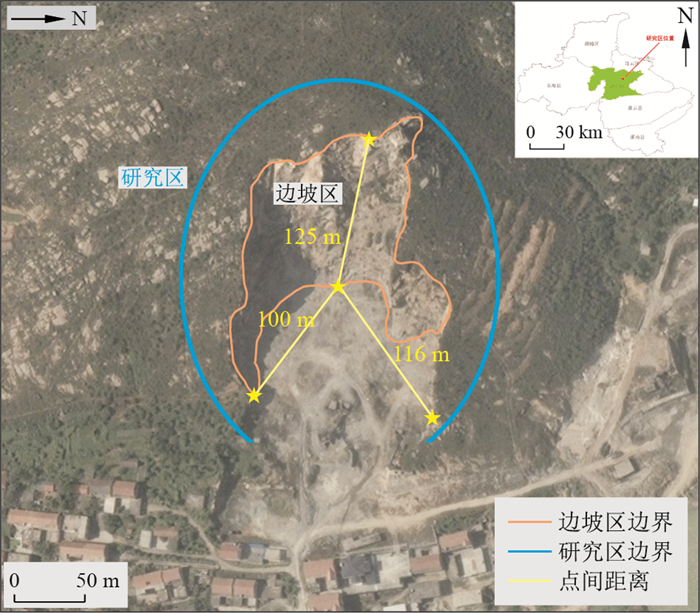
图 1 研究区地理位置分布图(影像来源:Google Earth)
Figure 1. Geographical distribution map of the study area

图 2 基于无人机倾斜摄影技术的崩塌隐患早期识别及影响区划分方法体系
Figure 2. Method of early identification and influence range division of collapse hazards based on UAV oblique photography technology

图 6 岩质边坡失稳模式判别赤平投影图
Figure 6. Stereographic projection for identification of rock slope instability mode

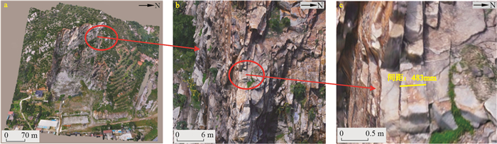
图 8 研究区三维实景模型
a.全局视图; b.局部视图; c.细节描述(精度mm)
Figure 8. 3D real scene model of the study area

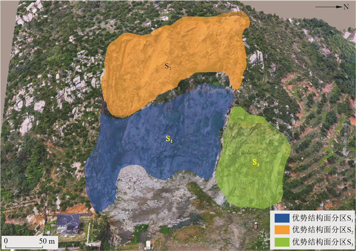
图 12 研究区结构面组合关系分区示意图
Figure 12. Schematic diagram of structural plane combination relations of the study area

图 13 基于赤平投影法的S2区边坡失稳模式判别分析
J1、J2、J3.S2区优势结构面;1-2.优势结构面1,2交线;1-3.优势结构面1,3交线;2-3.优势结构面2,3交线
Figure 13. Discriminant analysis of slope instability modes based on stereographic projection method in S2 area

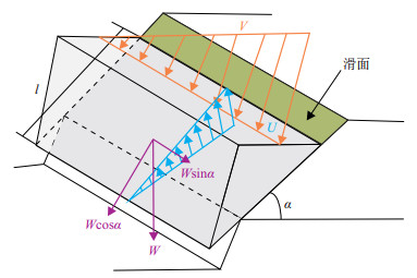
图 14 滑移式崩塌稳定性计算模型
U为滑面水压力(kN·m-1);V为后缘裂隙水压力(kN·m-1);W为岩体自重(kN·m-1); α为倾角(°);l为滑面长度(m)
Figure 14. Computational model of sliding collapse stability

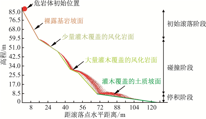
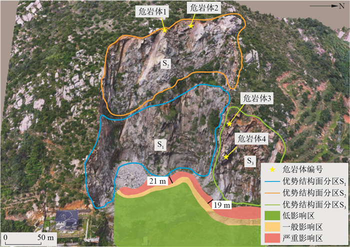
图 19 危岩体崩落影响区划分示意图
Figure 19. Schematic diagram of the influence areas for caving of dangerous rock mass
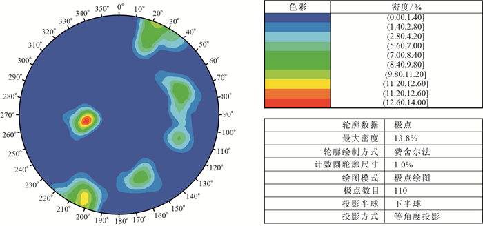
表 1 边坡区优势结构面产状信息汇总
Table 1. Summary of occurrence information of advantageous structural plane in slope area
代表区域 结构面编号 产状 形态 填充特性 间距/cm 张开度/mm 结构面分级 S1 Js1-1 24°∠85° 平直 断续填充 61 0.25 Ⅳ级 S2 Js2-1 78°∠39° 平直 薄膜填充 87 0.20 Ⅳ级 Js2-2 340°∠68° 平直 薄膜填充 116 0.25 Ⅳ级 Js2-3 245°∠64° 平直 薄膜填充 65 0.15 Ⅳ级 S3 Js3-1 285°∠67° 平直 薄膜填充 75 0.25 Ⅳ级 Js3-2 204°∠81° 平直 薄膜填充 25 0.10 Ⅳ级 Js3-3 85°∠35° 平直 薄膜填充 68 0.20 Ⅳ级  下载: 导出CSV
表 2 危岩体稳定性统计
Table 2. Dangerous rock mass stability statistics
编号 工况 滑面长度/m 裂隙深度/m 滑面倾角/(°) 下滑力/kN 抗滑力/kN 稳定性系数 稳定性 危岩体1 天然 2.6 1.3 55 137.6 148.5 1.07 欠稳定 暴雨 2.6 1.3 55 141.8 137.4 0.97 不稳定 危岩体2 天然 8.0 3.2 62 219.1 242.0 1.10 欠稳定 暴雨 8.0 3.2 62 236.5 217.6 0.92 不稳定 危岩体3 天然 5.7 2.8 51 172.7 207.3 1.20 基本稳定 暴雨 5.7 2.8 51 198.4 194.4 0.98 不稳定 危岩体4 天然 6.4 5.8 58 248.9 251.4 1.01 欠稳定 暴雨 6.4 5.8 58 269.1 242.2 0.90 不稳定
下载: 导出CSV
-
[1] Niethammer U, James M R. UAV-based remote sensing of the Super-Sauze landslide: Evaluation and results[J]. Engineering Geology, 2012, 128(11): 2-11. http://www.onacademic.com/detail/journal_1000035044244410_dd55.html [2] Li Z, Zhang X Z. Researth on the quick construction of 3D model of city based on oblique photogrammertric technique[J]. Geomatics&Spatial Information Technology, 2012, 35(4): 117-119. http://en.cnki.com.cn/Article_en/CJFDTOTAL-DBCH201204038.htm [3] 陈麒玉, 刘刚, 何珍文, 等. 面向地质大数据的结构-属性一体化三维地质建模技术现状与展望[J]. 地质科技通报, 2020, 39(4): 51-58. doi: 10.19509/j.cnki.dzkq.2020.0407Chen Q Y, Liu G, He Z W, et al. Current situation and prospect of structure-attribute integrated 3D geological modeling technology for geological big date[J]. Bulletin of Geological Science and Technology, 2020, 39(4): 51-58(in Chinese with English abstract). doi: 10.19509/j.cnki.dzkq.2020.0407 [4] 许腾晖. 西藏日喀则紫金山危岩破坏模式及失稳运动特征研究[D]. 成都: 成都理工大学, 2019.Xu T H. Study on failure mode and instability motion characteristics of perilous rocks in Zijin Mountain, Xigaze, Tibet[D]. Chengdu: Chengdu University of Technology, 2019(in Chinese with English abstract). [5] Sturzenegger M, Stead D. Close-range terrestrial digital photogrammetry and terrestrial laser scanning for discontinuity characterization on rock cuts[J]. Engineering Geology, 2009, 106(3): 163-182. http://www.onacademic.com/detail/journal_1000034074653510_164b.html [6] Uysal M, Toprak A S, Polat N. DEM generation with UAV photogrammetry and accuracy analysis in Sahitler hill[J]. Measurement, 2015, 73(1): 539-543. http://www.sciencedirect.com/science/article/pii/S0263224115003243 [7] 郭晨, 许强, 董秀军, 等. 无人机在重大地质灾害应急调查中的应用[J]. 测绘通报, 2020(10): 6-11, 73. https://www.cnki.com.cn/Article/CJFDTOTAL-CHTB202010002.htmGuo C, Xu Q, Dong X J, et al. Application of UAV photogrammetry technology in the emergency rescue of catastrophic geohazards[J]. Bulletin of Surveying and Mapping, 2020(10): 6-11, 73(in Chinese with English abstract). https://www.cnki.com.cn/Article/CJFDTOTAL-CHTB202010002.htm [8] 叶震, 许强, 刘谦, 等. 无人机倾斜摄影测量在边坡岩体结构面调查中的应用[J]. 武汉大学学报: 信息科学版, 2020, 45(11): 1739-1746. https://www.cnki.com.cn/Article/CJFDTOTAL-WHCH202011010.htmYe Z, Xu Q, Liu Q, et al. Application of unmanned aerial vehicle oblique photogrammetry to investigation of high slope rock structure[J]. Geomatics and Information Science of Wuhan University, 2020, 45(11): 1739-1746(in Chinese with English abstract). https://www.cnki.com.cn/Article/CJFDTOTAL-WHCH202011010.htm [9] 谢金, 杨根兰, 覃乙根, 等. 基于无人机与Rockfall的危岩体结构特征识别与运动规律模拟[J]. 河南理工大学学报: 自然科学版, 2021, 40(1): 55-64. https://www.cnki.com.cn/Article/CJFDTOTAL-JGXB202101007.htmXie J, Yang G L, Qin Y G, et al. Recognition of dangerous rock mass structure characteristic and movement law simulation based on UAV and Rockfall[J]. Journal of Henan Polytechnic University: Natural Science Edition, 2021, 40(1): 55-64(in Chinese with English abstract). https://www.cnki.com.cn/Article/CJFDTOTAL-JGXB202101007.htm [10] 陈宙翔, 叶咸, 张文波, 等. 基于无人机倾斜摄影的强震区公路高位危岩崩塌形成机制及稳定性评价[J]. 地震工程学报, 2019, 41(1): 257-267. https://www.cnki.com.cn/Article/CJFDTOTAL-ZBDZ201901037.htmChen Z X, Ye X, Zhang W B, et al. Formation mechanism analysis and stability evaluation of dangerous rock collapses based on the oblique photography by unmanned aerial vehicles[J]. China Earthquake Engineering Journal, 2019, 41(1): 257-267(in Chinese with English abstract). https://www.cnki.com.cn/Article/CJFDTOTAL-ZBDZ201901037.htm [11] 黄海宁, 黄健, 周春宏, 等. 无人机影像在高陡边坡危岩体调查中的应用[J]. 水文地质工程地质, 2019, 46(6): 149-155. https://www.cnki.com.cn/Article/CJFDTOTAL-SWDG201906021.htmHuang H N, Huang J, Zhou C H, et al. Application of UAV images to rockfall investigation at the high and steep slope[J]. Hydrogeology & Engineering Geology, 2019, 46(6): 149-155(in Chinese with English abstract). https://www.cnki.com.cn/Article/CJFDTOTAL-SWDG201906021.htm [12] Dorren L, Maier B, Putters U S, et al. Combining field and modelling techniques to assess rockfall dynamics on a protection forest hillslope in the European Alps[J]. Geomorphology, 2004, 57(3/4): 151-167. [13] Utlu M, Ozturk M Z, Imek M. Rockfall analysis based on UAV technology in Kazklali Gorge, Aladalar(Taurus Mountains, Turkey)[J]. International Journal of Environment and Geoinformatics, 2020, 7(3): 239-251. http://www.researchgate.net/publication/344249492_Rockfall_analysis_based_on_UAV_technology_in_Kazikliali_Gorge_Aladaglar_Taurus_Mountains_Turkey [14] 陈泰江, 章广成, 向欣. 非均一性斜坡落石运动轨迹[J]. 地质科技通报, 2021, 40(4): 196-203. doi: 10.19509/j.cnki.dzkq.2021.0413Chen T Z, Zhang G C, Xiang X. Trajectory of rockfall on the uniform slope[J]. Bulletin of Geological Science and Technology, 2021, 40(4): 196-203(in Chinese with English abstract). doi: 10.19509/j.cnki.dzkq.2021.0413 [15] Alexandre B, Renaud M. Deep learning for robust normal estimation in unstructured point clouds[J]. Computer Graphics Forum, 2016, 35(5): 281-290. http://smartsearch.nstl.gov.cn/paper_detail.html?id=7215b51fe6a693a4dba809c89926ad73 [16] 赵帅. POS辅助空中三角测量技术现状及关键问题研究[D]. 西安: 西安科技大学. 2012.Zhao S. Research to technical state and key problems of POS supported aerial triangulation[D]. Xi'an: Xi'an University of Science and Technology, 2012(in Chinese with English abstract). [17] Thiele S T, Lachlan G, Anindita S, et al. Rapid, semi-automatic fracture and contact mapping for point clouds, images and geophysical data[J]. Solid Earth, 2017, 8(6): 1241-1253. http://www.solid-earth.net/8/1241/2017/se-8-1241-2017.pdf [18] 李水清, 张慧超, 刘乳燕. 无人机摄影测量半自动统计岩体结构面产状[J]. 科学技术与工程, 2017, 17(26): 18-22. https://www.cnki.com.cn/Article/CJFDTOTAL-KXJS201726003.htmLi S Q, Zhang H C, Liu R Y, et al. Semi-automatically counting orientation of rock mass structural plane based on unmanned aerial vehicle photogrammetry[J]. Science Technology and Engineering, 2017, 17(26): 18-22(in Chinese with English abstract). https://www.cnki.com.cn/Article/CJFDTOTAL-KXJS201726003.htm [19] 万剑华, 王朝, 刘善伟, 等. 倾斜摄影测量构建地质数字露头[J]. 地质科技情报, 2019, 38(1): 258-264. https://www.cnki.com.cn/Article/CJFDTOTAL-DZKQ201901029.htmWan J H, Wang C, Liu S W, et al. Reconsting geological digital outcrops with oblique photogrammetry[J]. Geological Science and Technology Information, 2019, 38(1): 258-264(in Chinese with English abstract). https://www.cnki.com.cn/Article/CJFDTOTAL-DZKQ201901029.htm [20] 刘昌军, 丁留谦, 孙东亚. 基于激光点云数据的岩体结构面全自动模糊群聚分析及几何信息获取[J]. 岩石力学与工程学报, 2011, 30(2): 358-364. https://www.cnki.com.cn/Article/CJFDTOTAL-YSLX201102021.htmLiu C J, Ding L Q, Sun D Y. Automatic fuzzy clustering analysis and geometric information acquisition of rock mass discontinuities based on laser point cloud data[J]. Chinese Journal of Rock Mechanics and Engineering, 2011, 30(2): 358-364(in Chinese with English abstract). https://www.cnki.com.cn/Article/CJFDTOTAL-YSLX201102021.htm [21] Hoek E. 岩石边坡工程[M]. 北京: 冶金工业出版社, 1983.Hoek E. Rock slope engineering[M]. Beijing: Metallurgical Industry Press, 1983(in Chinese). [22] Chen H K, Tang H M, Wang R. Calculation method of stability for unstable rock and application to the three gorges reservoir[J]. Chinese Journal of Rock Mechanics and Engineering, 2004, 23(4): 614-619. [23] 谷飞宏, 王亮清, 刘庆涛, 等. 赤平投影法确定边坡稳定性系数[J]. 华北水利水电学院学报, 2011, 32(4): 119-121. https://www.cnki.com.cn/Article/CJFDTOTAL-HBSL201104035.htmGu F H, Wang L Q, Liu Q T, et al. Determination of slope stability coefficient by hemispherical projection method[J]. Journal of North China University of Water Resources and Electric Power, 2011, 32(4): 119-121(in Chinese with English abstract). https://www.cnki.com.cn/Article/CJFDTOTAL-HBSL201104035.htm [24] 陈祖煜. 岩质边坡稳定分析原理·方法·程序[M]. 北京: 中国水利水电出版社, 2005.Chen Z Y. Stability analysis of rock slope principles, methods and procedures[M]. Beijing: China Water & Power Press, 2005(in Chinese). [25] 唐红梅, 李阳, 王林峰. 三峡库区陡高边坡落石运动特性数值模拟分析[J]. 重庆师范大学学报: 自然科学版, 2019, 36(4): 49-54. https://www.cnki.com.cn/Article/CJFDTOTAL-CQSF201904009.htmTang H M, Li Y, Wang L F. Numerical simulation analysis of rock movement characteristics of steep high slope in Three Gorges reservoir area[J]. Journal of Chongqing Normal University: Natural Science Edition, 2019, 36(4): 49-54(in Chinese with English abstract). https://www.cnki.com.cn/Article/CJFDTOTAL-CQSF201904009.htm -

 下载:
下载:


 点击查看大图
计量
- 文章访问数: 798
- PDF下载量: 251
- 被引次数: 0
