


Identification of geological hazards based on the combination of InSAR technology and disaster background indicators
-
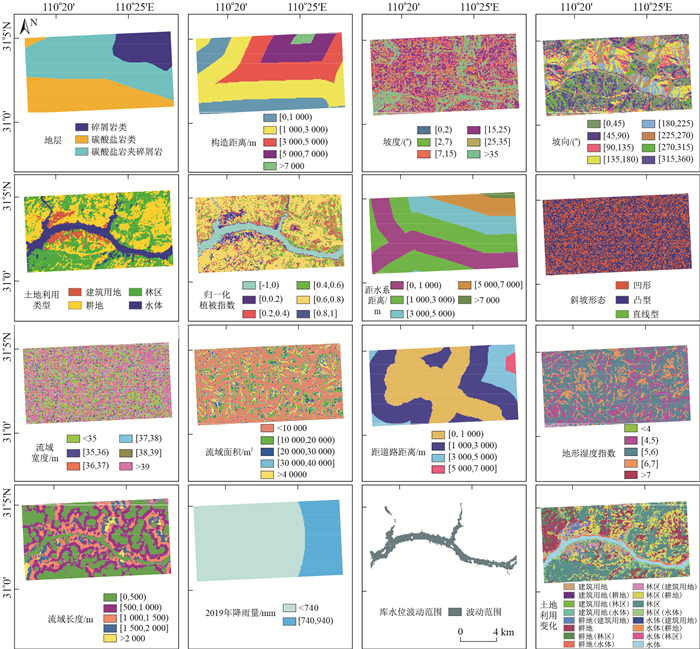
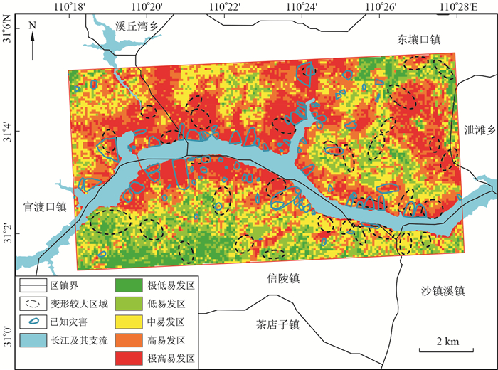
摘要: 合成孔径雷达干涉测量(interferometric synthetic aperture radar, 简称InSAR)是获取地表形变的重要手段, 由于InSAR数据获取的限制和数据处理中产生的精度误差等问题, 在地灾隐患识别方面的工作还需要联合地质灾害本身进行分析。为此提出了一种基于InSAR技术与研究区孕灾背景指标相结合的方法, 并将其应用于三峡库区巴东段的地灾隐患识别研究中。研究结果表明, 使用ALOS-2 PALSAR雷达影像, 应用时序InSAR技术得到了研究区的变形空间分布和变化速率, 并结合研究区的孕灾背景, 将易发性等级、坡度、工程岩组和是否与灾害目录重叠4个指标作为地灾隐患判别的指标, 综合识别出19处疑似地灾隐患区, 然后对疑似地灾隐患区进行了逐一野外核查, 经验证地灾隐患识别成功率为78.9%。研究成果证明了将InSAR技术和孕灾背景相结合进行地灾隐患识别方法的可行性, 可在区域灾害识别中发挥重要作用。Abstract: Synthetic aperture radar interferometry (InSAR) is an important method to obtain surface deformation information. Due to the limitations of InSAR data acquisition and the accuracy errors produced in the data processing, the identification of hidden dangers also needs to be combined with the analysis of geological hazards themselves, so a method based on InSAR technology combined with the disaster-pregnancy background in the study area is proposed. This study took the Badong section of the Three Gorges Reservoir area as the study area, and ALOS-2 PALSAR radar images were used to obtain the spatial distribution and change rate of deformation in the study area by using time-series InSAR technology. Combining the disaster-prone background of the study area, four indicators of the susceptibility level, slope, engineering rock group and distance from the disaster catalogue point are used as indicators for the identification of hidden dangers of geological disasters. As a result, 19 suspected hidden disaster areas were identified comprehensively, and then the suspected hidden geological disaster areas were verified in the field one by one. The success rate of verification and identification was 78.9%, proving that the method combining the disaster pregnancy background and InSAR results is feasible and can play an important role in regional disaster identification.
-
Key words:
- recognition of hidden geological hazards /
- InSAR /
- ALOS-2 /
- disaster background indicators /
- Badong
-

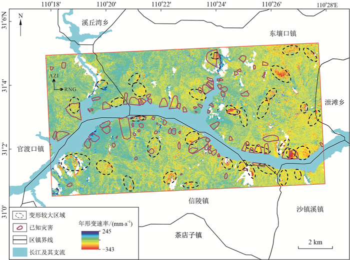
图 3 雷达视线方向的年均形变速率
Figure 3. Average variable speed of deformation along the radar line of sight

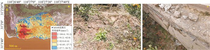
图 8 P2变形区InSAR监测形变速率(a)及现场照片(b, c)
a.雷达视线向形变速率; b.地面裂缝现场照片; c.路基裂缝
Figure 8. InSAR monitoring deformation rate (a) and on-site photos (b, c) of the deformation zone P2
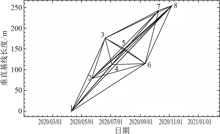
表 1 ALOS-2数据成像时间表
Table 1. Timeline of ALOS-2 digital imaging
序号 成像时间 1 2020/04/11 2 2020/05/23 3 2020/06/20 4 2020/07/04 5 2020/08/01 6 2020/09/12 7 2020/10/10 8 2020/11/07  下载: 导出CSV
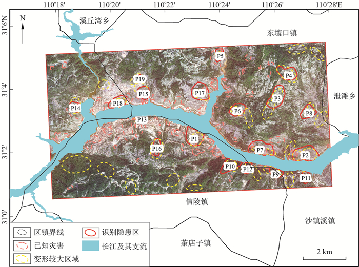
表 2 地灾隐患区判别指标情况
Table 2. Conditions of evaluation indicators of potential dazard areas
编号 判别指标 判别指标个数 易发性等级 坡度/(°) 工程岩组 是否与灾害目录重叠 P1 极高易发 10~20 较软 是 4 P2 极高易发 20~30 较软 是 4 P3 高易发 10~20 极软 否 3 P4 极高易发 20~30 极软 否 3 P5 极高易发 20~30 坚硬 是 3 P6 高易发 10~20 极软 是 4 P7 极高易发 20~30 较软 是 4 P8 极高易发 20~30 极软 否 3 P9 中易发 20~30 软岩 是 4 P10 中易发 30~40 软岩 是 4 P11 中易发 10~20 软岩 否 3 P12 中易发 30~40 软岩 是 4 P13 极高易发 20~30 较软 是 4 P14 极高易发 20~30 坚硬 是 3 P15 极高易发 10~20 坚硬 是 3 P16 高易发 20~30 较软 是 4 P17 极高易发 10~20 较软 是 4 P18 极高易发 10~20 坚硬 是 3 P19 极高易发 10~20 坚硬 否 2
下载: 导出CSV
表 3 潜在地灾点位及变形特征统计
Table 3. Statistics table of potential hazard sites and deformation characteristics
编号 最大沉降速率/ (mm·a-1) 经度 纬度 变形特征 证实灾种 P1 -156.746 110° 23' 10.470" E 31° 2' 30.743" N 公路发育多条沉降变形裂缝,已废弃建筑物墙开裂,公路变形长度约10 m 滑坡 P2 -186.597 110° 27' 11.149" E 31° 1' 57.373" N 道路存在裂缝,走向220°,深度约40 cm 滑坡 P3 -166.277 110° 26' 1.313" E 31° 3' 40.856" N 可见公路发育弧形裂缝,走向195°,缝宽约1 cm,长约8 m 滑坡 P4 -203.549 110° 26' 31.105" E 31° 4' 29.182" N 公路存在多处弧形裂缝(2020年),走向266°,宽约3 cm,长约5 m,最深处约10 cm 滑坡 P5 -164.861 110° 24' 5.021" E 31° 5' 2.746" N 公路前缘,橘树发育下挫裂缝,走向188°,长约8 m,最大下挫深度约0.5 m,呈直线型,缝宽1~2 cm,多级干砌石挡墙存在局部垮塌 滑坡 P6 -106.729 110° 24' 43.590" E 31° 3' 20.615" N 道路存在裂缝,走向308°,宽约2 cm,地表下座0.5 m,东瀼口村9组38号,经调查为煤矿开采引起地面下沉 地面沉降 P7 -176.093 110° 25' 32.555" E 31° 2' 8.815" N 变形区西侧为冲沟,坡度约50°,坡面存在大量松散堆积体;变形区东侧为道路切坡,坡高2~4 m 滑坡 P8 -262.390 110° 27' 19.755" E 31° 3' 14.473" N 该处主要为农田及林地,表层土体结构松散 非地灾 P9 -164.571 110° 26' 7.869" E 31° 1' 25.261" N 未见公路及斜坡变形裂缝,位于沿江处,考虑为水体对InSAR的影响 非地灾 P10 -238.687 110° 24' 28.435" E 31° 1' 36.568" N 位于茶麻沟泥石流附近,为沿公路的林地 滑坡 P11 -130.077 110° 27' 12.314" E 31° 1' 17.071" N 顺公路方向出现裂缝,宽1~2 mm,长约15 m,外沿开裂,斜坡较陡 滑坡 P12 -123.997 110° 25' 5.682" E 31° 1' 30.042" N 位于红龙坪滑坡附近 滑坡 P13 -130.387 110° 21' 18.590" E 31° 3' 4.134" N 位于已知隐患点附近,在长江南岸公路边坡,有锚杆治理护坡,可见变形监测墩 滑坡 P14 -110.139 110° 18' 54.160" E 31° 3' 23.752" N 位于杜公祠滑坡附近 滑坡 P15 -89.087 110° 21' 19.359" E 31° 3' 51.381" N 居民房前见裂缝,走向198°,长约12 m,宽1~5 m,房前地坪开裂,地坪前挡墙存在明显鼓胀变形和多条平行裂缝,公路内侧干砌石挡墙变形 滑坡 P16 -150.895 110° 21' 50.151" E 31° 2' 11.801" N 公路内测有治理的高陡边坡,为已知隐患点 滑坡 P17 -127.195 110° 23' 22.820" E 31° 3' 53.268" N 坡面种植橘树,坡度大,降雨时坡面汇水易使水土流失,坡面覆盖层为粉质黏土夹碎石 非地灾 P18 -124.919 110° 20' 26.353" E 31° 3' 34.400" N 该点为太矶头集镇垃圾处理填埋场,由于填埋生活垃圾,局部挖填取土 非地灾 P19 -106.789 110° 21' 11.969" E 31° 4' 18.647" N 现场为一施工工地,大量抗滑桩正在建设,地表土体有明显的施工开挖迹象,土层厚6~8 m。坐标点北侧房屋前于2020年4-5月发生滑移 滑坡
下载: 导出CSV
-
[1] 许强, 董秀军, 李为乐. 基于天-空-地一体化的重大地质灾害隐患早期识别与监测预警[J]. 武汉大学学报: 信息科学版, 2019, 44(7): 957-966.Xu Q, Dong X J, Li W L. Integrated space-air-ground early detection, monitoring and warning system for potential catastrophic geohazards[J]. Geomatics and Information Science of Wuhan University, 2019, 44(7): 957-966(in Chinese with English abstract). [2] Rosin P L, Hervás J, Barredo J I. Remote sensing image thresholding for landslide motion detection[C]//Anon. 1st Int. Workshop on Pattern Recognition Techniques in Remote Sensing. [S. l. ]: [s. n. ], 2000: 10-17. [3] Barlow J, Martin Y, Franklin S E. Detecting translational landslide scars using segmentation of Landsat ETM+ and DEM data in the northern Cascade Mountains, British Columbia[J]. Canadian Journal of Remote Sensing, 2003, 29(4): 510-517. doi: 10.5589/m03-018 [4] Chang Y L, Liang L S, Han C C, et al. Multisource data fusion for landslide classification using generalized positive boolean functions[J/OL]. IEEE Transactions on Geoscience and Remote Sensing, 2007, 45(6): 1697-1708. [5] Khairunniza-Bejo S, Petrou M, Ganas A. Local similarity measure for landslide detection and identification in comparison with the image differencing method[J]. International Journal of Remote Sensing, 2010, 31(23): 6033-6045. doi: 10.1080/01431160903376365 [6] Hölbling D, Friedl B, Eisank C. An object-based approach for semi-automated landslide change detection and attribution of changes to landslide classes in northern Taiwan[J/OL]. Earth Science Informatics, 2015, 8(2): 327-335. [7] Marjanovi M, Kovaevi M, Bajat B, et al. Landslide susceptibility assessment using SVM machine learning algorithm[J]. Engineering Geology, 2011, 123(3): 225-234. doi: 10.1016/j.enggeo.2011.09.006 [8] Catani F, Lagomarsino D, Segoni S, et al. Landslide susceptibility estimation by random forests technique: Sensitivity and scaling issues[J]. Natural Hazards and Earth System Sciences, 2013, 13(11): 2815-2831. doi: 10.5194/nhess-13-2815-2013 [9] Liu Y, Wu L. Geological disaster recognition on optical remote sensing images using deep learning[J]. Procedia Computer Science, 2016, 91: 566-575. doi: 10.1016/j.procs.2016.07.144 [10] Yu H, Ma Y, Wang L, et al. A landslide intelligent detection method based on CNN and RSG-R[C]//Anon. 2017 IEEE International Conference on Mechatronics and Automation. [S. l. ]: [s. n. ]: IEEE, 2017: 40-44. [11] 王超, 张红, 刘智. 星载合成孔径雷达干涉测量[M]. 北京: 科学出版社, 2002.Wang C, Zhang H, Liu Z. Spaceborne synthetic aperture radar interferometry[M]. Beijing: China Science Publishing & Media Ltd., 2002(in Chinese). [12] Dong J, Zhang L, Tang M, et al. Mapping landslide surface displacements with time series SAR interferometry by combining persistent and distributed scatterers: A case study of Jiaju landslide in Danba, China[J]. Remote Sensing of Environment, 2018, 205: 180-198. doi: 10.1016/j.rse.2017.11.022 [13] Shi X, Liao M, Li M, et al. Wide-area landslide deformation mapping with multi-path ALOS PALSAR data stacks: A case study of three gorges area, China[J]. Remote Sensing, 2016, 8(2): 136. doi: 10.3390/rs8020136 [14] 张路, 龚健雅, 廖明生, 等. 基于时间序列InSAR分析的西部山区滑坡灾害隐患早期识别: 以四川丹巴为例[J]. 武汉大学学报: 信息科学版, 2018, 43(12): 2039-2049. https://www.cnki.com.cn/Article/CJFDTOTAL-WHCH201812031.htmZhang L, Gong J Y, Liao M S, et al. Early detection of landslide hazards in mountainous areas of west China using time series SAR interferometry: A case study of danba, Sichuan[J]. Geomatics and Information Science of Wuhan University, 2018, 43(12): 2039-2049(in Chinese with English abstract). https://www.cnki.com.cn/Article/CJFDTOTAL-WHCH201812031.htm [15] Rosi A, Tfoani V, Tanteri L, et al. The new landslide inventory of Tuscany (Italy) updated with PS-InSAR: Geomorphological features and landslide distribution[J]. Landslides, 2018, 15(1): 5-19. doi: 10.1007/s10346-017-0861-4 [16] 蔡杰华, 张路, 董杰, 等. 九寨沟震后滑坡隐患雷达遥感早期识别与形变监测[J]. 武汉大学学报: 信息科学版, 2020, 45(11): 17107-1716. https://www.cnki.com.cn/Article/CJFDTOTAL-WHCH202011007.htmCao J H, Zhang L, Dong J, et al. Detection and monitoring of post-earthquake landslides in Jiuzhaigou using radar remote sensing[J]. Geomatics and Information Science of Wuhan University, 2020, 45(11): 1707-1716(in Chinese with English abstract) https://www.cnki.com.cn/Article/CJFDTOTAL-WHCH202011007.htm [17] Liu X, Zhao C, Zhang Q, et al. Integration of sentinel-1 and ALOS/PALSAR-2 SAR datasets for mapping active landslides along the Jinsha River corridor, China[J]. Engineering Geology, 2021, 284: 106033. doi: 10.1016/j.enggeo.2021.106033 [18] 葛大庆, 戴可人, 郭兆成, 等. 重大地质灾害隐患早期识别中综合遥感应用的思考与建议[J]. 武汉大学学报: 信息科学版, 2019, 44(7): 949-956. https://www.cnki.com.cn/Article/CJFDTOTAL-WHCH201907001.htmGe D Q, Dai K R, Guo Z C, et al. Early identification of serious geological hazards with integrated remote sensing technologies: Thoughts and recommendations[J]. Geomatics and Information Science of Wuhan University, 2019, 44(7): 949-956(in Chinese with English abstract). https://www.cnki.com.cn/Article/CJFDTOTAL-WHCH201907001.htm [19] 贺凯, 李滨, 赵超英, 等. 基于易滑地质结构与多源数据差异的岩溶山区大型崩滑灾害识别研究[J]. 中国岩溶, 2020, 39(4): 467-477. https://www.cnki.com.cn/Article/CJFDTOTAL-ZGYR202004002.htmHe K, Li B, Zhao C Y, et al. Identification of large-scale landslide hazards based on differences of geological structure prone to sliding and multiple-source data in karst mountainous areas[J]. Carsologica Sinica, 2020, 39(4): 467-477(in Chinese with English abstract). https://www.cnki.com.cn/Article/CJFDTOTAL-ZGYR202004002.htm [20] 胡燕, 李德营, 孟颂颂, 等. 基于证据权法的巴东县城滑坡灾害易发性评价[J]. 地质科技通报, 2020, 39(3): 187-194. doi: 10.19509/j.cnki.dzkq.2020.0320Hu Y, Li D Y, Meng S S, et al. andslide susceptibility evaluation in Badong County based on weights of evidence method[J]. Bulletin of Geological Science and Technology, 2020, 39(3): 187-194(in Chinese with English abstract). doi: 10.19509/j.cnki.dzkq.2020.0320 [21] Liu X, Zhao C, Zhang Q, et al. Multi-temporal loess landslide inventory mapping with C-, X- and L-Band SAR datasets: A case study of Heifangtai loess landslides, China[J]. Remote Sensing, 2018, 10(11): 1756. doi: 10.3390/rs10111756 [22] Zhang T, Xie S, Fan J, et al. Detection of active landslides in southwest China using Sentinel-1 and ALOS-2 data[J]. Procedia Computer Science, 2021, 181: 1138-1145. doi: 10.1016/j.procs.2021.01.311 [23] Berardino P, Fornaro G, Lanari R, et al. A new algorithm for surface deformation monitoring based on small baseline differential SAR interferograms[J]. IEEE Transactions on Geoscience and Remote Sensing, 2002, 40(11): 2375-2383. doi: 10.1109/TGRS.2002.803792 [24] Dong J, Zhang L, Liao M, et al. Improved correction of seasonal tropospheric delay in InSAR observations for landslide deformation monitoring[J]. Remote Sensing of Environment, 2019, 233: 111370. doi: 10.1016/j.rse.2019.111370 [25] Tong X, Schmidt D. Active movement of the Cascade landslide complex in Washington from a coherence-based InSAR time series method[J]. Remote Sensing of Environment, 2016, 186: 405-415. doi: 10.1016/j.rse.2016.09.008 [26] 刘广全. 基于SBAS-InSAR的丹巴县滑坡探测与监测[D]. 西安: 长安大学, 2015.Liu Guangquan. Landslide detection and monitoring of Danba County based on SBAS-InSAR[D]. Xi'an: Chang'an University, 2015(in Chinese with English abstract). [27] 石固林, 徐浪, 张璇钰, 等. 西山村滑坡时序形变的SBAS-InSAR监测[J]. 测绘科学, 2021, 46(2): 93-98, 105. https://www.cnki.com.cn/Article/CJFDTOTAL-CHKD202102014.htmShi G L, Xu L, Zhang X Y, et al. Monitoring time series deformation of Xishancun landslide with SBAS-InSAR[J]. Science of Survering and Mapping, 2021, 46(2): 93-98, 105(in Chinese with English abstract). https://www.cnki.com.cn/Article/CJFDTOTAL-CHKD202102014.htm [28] 孟禹弛. 基于雷达影像的矿区地面沉降监测系统的研究与实现[D]. 江苏徐州: 中国矿业大学, 2017.Meng Y C. Study and implementation of mining area land subsidence monitoring system basede on SAR data[D]. Xuzhou Jiangsu: China University of Mining and Technology, 2017(in Chinese with English abstract). [29] Lauknes T T, Piyush Shanker A, Dehls J F, et al. Detailed rockslide mapping in northern Norway with small baseline and persistent scatterer interferometric SAR time series methods[J]. Remote Sensing of Environment, 2010, 114(9): 2097-2109. doi: 10.1016/j.rse.2010.04.015 [30] 戴可人, 铁永波, 许强, 等. 高山峡谷区滑坡灾害隐患InSAR早期识别: 以雅砻江中段为例[J]. 雷达学报, 2020, 9(3): 554-568. https://www.cnki.com.cn/Article/CJFDTOTAL-LDAX202003012.htmDao K R, Tie Y B, Xu Q, et al. Early identification of potential landslide geohazards in alpine-canyon terrain based on SAR interferometry: A case study of the middle section of yalong river[J]. Journal of Radars, 2020, 9(3): 554-568(in Chinese with English abstract). https://www.cnki.com.cn/Article/CJFDTOTAL-LDAX202003012.htm [31] 牛瑞卿, 彭令, 叶润青, 等. 基于粗糙集的支持向量机滑坡易发性评价[J]. 吉林大学学报: 地球科学版, 2012, 42(2): 430-439. https://www.cnki.com.cn/Article/CJFDTOTAL-CCDZ201202019.htmNiu R Q, Peng L, Ye R Q, et al. Landslide susceptibility assessment based on rough sets and support vector machine[J]. Journal of Jilin University: Earth Science Edition, 2012, 42(2): 430-439(in Chinese with English abstract). https://www.cnki.com.cn/Article/CJFDTOTAL-CCDZ201202019.htm [32] 连志鹏, 徐勇, 付圣, 等. 采用多模型融合方法评价滑坡灾害易发性: 以湖北省五峰县为例[J]. 地质科技通报, 2020, 39(3): 178-186. doi: 10.19509/j.cnki.dzkq.2020.0319Lian Z P, Xu Y, Fu S, et al. Landslide susceptibility assessment based on multi-model fusion method: A case study in Wufeng County, Hubei Province[J]. Bulletin of Geological Science and Technology, 2020, 39(3): 178-186(in Chinese with English abstract). doi: 10.19509/j.cnki.dzkq.2020.0319 [33] Arabameri A, Pradhan B, Rezaei K, et al. Assessment of landslide susceptibility using statistical- and artificial intelligence-based FR-RF integrated model and multiresolution DEMs[J/OL]. Remote Sensing, 2019, 11(9). doi: 10.3390/rs11090999. [34] Abedini M, Tulabi S. Assessing LNRF, FR, and AHP models in landslide susceptibility mapping index: A comparative study of Nojian watershed in Lorestan province, Iran[J/OL]. Environmental Earth Sciences, 2018, 77(11). doi: 10.1007/s12665-018-7524-1. [35] Chen T, Zhu L, Niu R, et al. Mapping landslide susceptibility at the Three Gorges Reservoir, China, using gradient boosting decision tree, random forest and information value models[J]. Journal of Mountain Science, 2020, 17(3): 670-685. doi: 10.1007/s11629-019-5839-3 [36] Song Y, Niu R, Xu S, et al. Landslide susceptibility mapping based on weighted gradient boosting decision tree in Wanzhou section of the three gorges reservoir area (China)[J/OL]. ISPRS International Journal of Geo-Information, 2019, 8(1). doi: 10.3390/ijgi8010004. [37] Berhane G, Tadesse K. Landslide susceptibility zonation mapping using statistical index and landslide susceptibility analysis methods: A case study from Gindeberet district, Oromia Regional State, Central Ethiopia[J]. Journal of African Earth Sciences, 2021, 180: 104240. doi: 10.1016/j.jafrearsci.2021.104240 [38] 朱冬雪, 许强, 李松林. 三峡库区大型-特大型层状岩质滑坡成因模式及地质特征分析[J]. 地质科技通报, 2020, 39(2): 158-167. doi: 10.19509/j.cnki.dzkq.2020.0217Zhu D X, Xu Q, Li S L. Genetic types and geological features of large scale and extra-large scale layered landslides in the Three Gorges Reservoir area[J]. Bulletin of Geological Science and Technology, 2020, 39(2): 158-167(in Chinese with English abstract). doi: 10.19509/j.cnki.dzkq.2020.0217 -

 下载:
下载:


 点击查看大图
计量
- 文章访问数: 1371
- PDF下载量: 164
- 被引次数: 0

