


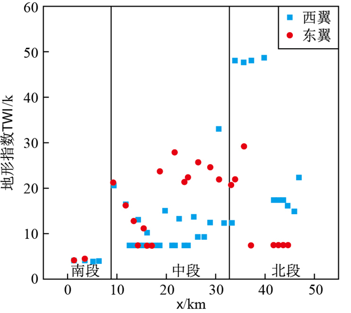
Depth of strong development of karst based on quantitative factors of hydrodynamic conditions
-
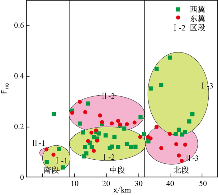
摘要: 地下水垂向循环水动力条件是岩溶发育深度的主要控制因素。为探求川东背斜构造岩溶区多级水流系统控制下的岩溶强发育深度,采用地理信息系统(GIS)技术,选取地形指数和水动力坡降构建岩溶水动力强弱的量化因子FHQ,并结合钻孔数据推求假角山背斜构造区地下岩溶强发育深度。研究显示:水动力因子FHQ与地形指数、水动力坡降在空间上呈明显正相关关系,同时可指示岩溶水流系统向深循环的深度,以此推求背斜构造区地下岩溶的强发育深度下限。假角山背斜两翼FHQ集中在0.1~0.4之间,岩溶水动力整体偏弱,深沟FHQ值整体高于浅沟。东、西翼深沟控制下的地下岩溶强发育深度分别约40~100 m和110~180 m;浅沟控制下的地下岩溶强发育深度分别约15~60 m和10~90 m。研究成果可进一步丰富川东背斜区岩溶发育评价方法体系,为隧道工程岩溶突水灾害预测防治提供理论依据。Abstract: The hydrodynamic condition of groundwater vertical circulation is the main factor to control the development depth of karst.In order to explore the karst strong development depth under the multistage flow system in the anticline karst area of East Sichuan.The quantitative factor of karst hydrodynamic strength(FHQ) is constructed by using GIS technology and selecting topographic index and hydrodynamic gradient.Combined with drilling data, the depth of strong development of underground karst in Jiajiao Mountain anticline structure area is calculated.The results show that the hydrodynamic factor FHQ is positively correlated with topographic index and hydrodynamic gradient in space.At the same time, it can indicate the depth of deep circulation of karst water flow system, so as to calculate the lower limit of strong development depth of underground karst in anticline structural areas.The FHQ of the two wings of the Jiajiao Mountain anticline is between 0.1 and 0.4, the karst hydrodynamic force is generally weak, and the FHQ value of the deep ditch is generally higher than that of the shallow ditch.The strong development depth of underground karst under the control of deep trenches in the east and west wings of anticline is about 40-100 m and 110-180 m respectively.It is hoped that the research results will further enrich the evaluation method system of karst development in east Sichuan anticline area.It also provides a theoretical basis for the prediction and prevention of karst water inrush disaster in tunnel engineering.
-

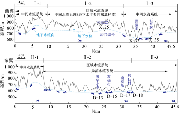
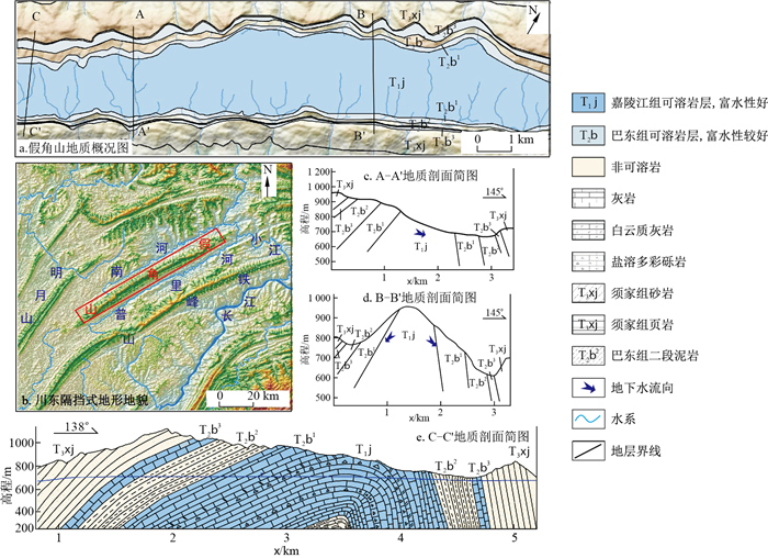
图 2 假角山背斜两翼T2b1/T2b2岩性界限处横切沟谷多级水流系统发育剖面图
Figure 2. Development profile of cross-cutting gully multistage water flow system at the lithologic boundary of T2b1/T2b2 on the two wings of Jiajiao Mountain anticline

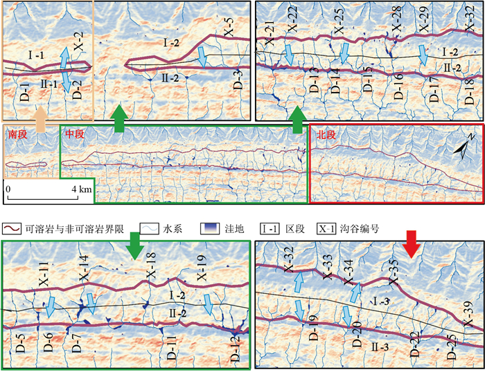
图 3 假角山背斜多级水流系统发育平面图
Figure 3. Development plan of multi-stage flow system in Jiajiao Mountain anticline

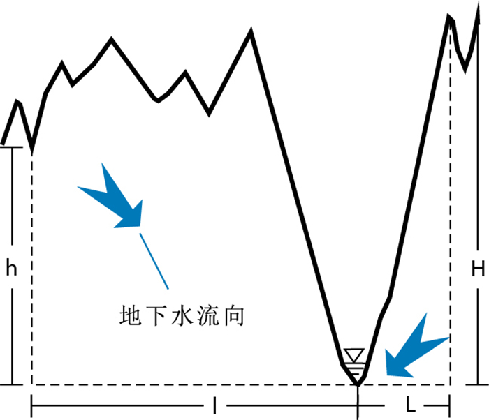
图 5 沟谷纵剖面水动力坡降示意图
H为沟底距坡顶的高差(m);L为沟底距坡顶的横向距离(m);h为浅沟沟底与其深沟排泄基准面的垂向距离(m);l为浅沟沟底与其深沟排泄基准面的横向距离(m)
Figure 5. Schematic diagram of hydrodynamic gradient of valley longitudinal section

图 6 沟谷水动力坡降计算结果对比图
Figure 6. Comparison of calculation results of valley hydrodynamic gradient
表 1 假角山背斜地下水循环模式
Table 1. Groundwater circulation model in Jiajiao Mountain anticline
构造部位 区段 地下水流系统 地下水循环模式 西翼 Ⅰ-1 中间水流系统 双侧浅切沟谷控制的地下水浅循环 Ⅰ-2 中间水流系统 单侧深切沟谷控制的地下水浅循环 Ⅰ-3 中间水流系统 双侧深切沟谷控制的地下水浅循环 东翼 Ⅱ-1 中间水流系统 双侧浅切沟谷控制的地下水浅循环 Ⅱ-2 局部水流系统 单侧深切沟谷控制的地下水浅循环 Ⅱ-3 局部水流系统 双侧深切沟谷控制的地下水浅循环  下载: 导出CSV
表 2 判断矩阵及一致性检验
Table 2. Matrix judgment and consistency detection
指标 TWI j J TWI 1 4 2 j 1/4 1 1 J 1/2 1 1 一致性检验λmax=3.053 6,CI=0.026 8,RI=0.52,CR=0.051 6 < 0.1,W=(0.584 2, 0.184 0, 0.231 8)T
下载: 导出CSV
表 3 水动力因子指标权重分配
Table 3. Weight distribution of hydrodynamic index
目标层 指标层 权重 水动力因子 TWI 0.584 2 J 0.231 8 j 0.184 0
下载: 导出CSV
表 4 FHQ指示下的岩溶强发育深度计算结果
Table 4. Calculation results of karst strong development depth under FHQ instruction
沟谷编号(对应钻孔) FHQ 钻孔深度/m 计算深度/m 沟谷编号(对应钻孔) FHQ 钻孔深度/m 计算深度/m 沟谷编号(对应钻孔) FHQ 钻孔深度/m 计算深度/m X-25(Z1) 0.24 64 52~64 D-17(Z3) 0.21 46 46~57 D-15(Z5) 0.27 60 59~73 D-18(Z2) 0.21 49 46~57 D-13(Z4) 0.28 64 60~74 沟谷编号 FHQ 计算深度/m 沟谷编号 FHQ 计算深度/m 沟谷编号 FHQ 计算深度/m 最小值 最大值 最小值 最大值 最小值 最大值 X-1 0.07 15 19 X-22 0.20 44 54 D-3 0.31 68 84 X-2 0.26 58 71 X-23 0.14 31 38 D-4 0.36 78 96 X-3 0.13 28 34 X-24 0.24 53 65 D-5 0.30 65 80 X-4 0.04 10 12 X-26 0.16 35 43 D-6 0.16 35 44 X-5 0.32 69 85 X-27 0.15 32 39 D-7 0.21 45 56 X-6 0.27 58 71 X-28 0.16 34 42 D-8 0.12 26 32 X-7 0.21 46 56 X-29 0.33 71 87 D-9 0.21 46 56 X-8 0.10 22 27 X-30 0.21 46 56 D-10 0.17 36 45 X-9 0.14 31 38 X-31 0.18 39 48 D-11 0.28 60 74 X-10 0.11 25 31 X-32 0.50 109 134 D-12 0.28 61 75 X-11 0.32 69 85 X-33 0.56 121 150 D-14 0.26 58 71 X-12 0.16 35 43 X-34 0.50 109 134 D-16 0.28 61 75 X-13 0.14 31 39 X-35 0.66 144 178 D-19 0.21 45 55 X-14 0.19 42 52 X-36 0.22 48 59 D-20 0.27 59 73 X-15 0.21 46 57 X-37 0.24 52 64 D-21 0.13 29 36 X-16 0.18 40 49 X-38 0.22 47 58 D-22 0.23 51 62 X-17 0.21 45 55 X-39 0.22 49 60 D-23 0.16 34 42 X-18 0.25 54 66 X-40 0.27 59 72 D-24 0.11 23 29 X-19 0.21 46 56 X-41 0.31 68 84 D-25 0.08 18 22 X-20 0.14 30 37 D-1 0.13 27 34 D-26 0.16 34 42 X-21 0.14 32 39 D-2 0.10 23 28 构造部位 FHQ 深度统计/m 构造部位 FHQ 深度统计/m 最小值 最大值 最小值 最大值 西翼 深沟 0.50~0.66 109 178 东翼 深沟 0.21~0.36 45 96 浅沟 0.04~0.33 10 87 浅沟 0.08~0.21 18 56
下载: 导出CSV
表 5 钻孔揭露值与推测值对比
Table 5. Comparison between exposed value and inferred value of borehole
钻孔编号 构造部位(对应沟谷编号) 钻孔揭露的强弱界限/m 计算值/m 误差范围/% Z1 西翼柏法村(X-25) 标高778 深度52~64,对应标高772~783 0.64~0.77 Z2 东翼凤仙村(D-18) 标高571 深度46~57,对应标高536~547 4.20~6.10 Z3 东翼南草-凤仙(D-17) 标高544 深度46~57,对应标高534~545 0.18~1.80 Z4 东翼善字小学(D-13) 标高502 深度60~74,对应标高491~505 0.59~2.19 Z5 东翼双碾村(附近)(D-15) 深度60 深度59~73 1.60~21.6
下载: 导出CSV
-
[1] 李苍松, 丁建芳, 廖烟开. 岩溶隧道地下水化学动力学及分形特征[M]. 北京: 科学出版社, 2017.Li C S, Ding J F, Liao Y K. Groundwater chemical kinetics and fractal characteristics of karst tunnel[M]. Beijing: Science Press, 2017(in Chinese). [2] 李钜章. 中国地貌形态基本类型数量指标初探[J]. 地理学报, 1982(1): 17-26. doi: 10.3321/j.issn:0375-5444.1982.01.003Li J Z. A preliminary study on quantitative indexes of basic types of geomorphology in China[J]. Acta Geographica Sinica, 1982(1): 17-26(in Chinese with English abstract). doi: 10.3321/j.issn:0375-5444.1982.01.003 [3] 熊道馄. 岩溶发育垂直分带及其工程地质意义[J]. 四川地质学报, 2004(2): 95-98. doi: 10.3969/j.issn.1006-0995.2004.02.009Xiong D K. Vertical zonation of karstification and its engineering geological significance[J]. Acta Geologica Sichuan, 2004(2): 95-98(in Chinese with English abstract). doi: 10.3969/j.issn.1006-0995.2004.02.009 [4] 孔凡哲, 芮孝芳. 基于地形特征的流域水文相似性[J]. 地理研究, 2003(6): 709-715. doi: 10.3321/j.issn:1000-0585.2003.06.005Kong F Z, Rui X F. Hydrological similarity of catchments based on topography[J]. Geographical Research, 2003(6): 709-715(in Chinese with English abstract). doi: 10.3321/j.issn:1000-0585.2003.06.005 [5] 薛显武, 陈喜, 张志才, 等. 基于地形因子特征值的喀斯特流域地貌类型判别[J]. 中国岩溶, 2009, 28(2): 175-180. doi: 10.3969/j.issn.1001-4810.2009.02.012Xue X W, Chen X, Zhang Z C, et al. Categorization of karst landform on the basis of landform factor eigenvalue[J]. Carsologica Sinica, 2009, 28(2): 175-180(in Chinese with English abstract). doi: 10.3969/j.issn.1001-4810.2009.02.012 [6] 钟玲敏, 许模, 吴明亮, 等. 多级水流系统耦合下深部岩溶分异研究: 以川东隔挡式构造区中梁山背斜南段为例[J]. 水文地质工程地质, 2018, 45(1): 45-51.Zhong L M, Xu M, Wu M L, et al. Development of deep karst under the coupling of multistage flow systems : A case of southern part of the Zhongliang Mountain anticline of the parallel barrier structure in eastern Sichuan[J]. Hydrogeology & Engineering Geology, 2018, 45(1): 45-51(in Chinese with English abstract). [7] 肖鸿林. 水力梯度对喀斯特峡谷形成的影响: 以猫跳河、六冲河为例[J]. 中国岩溶, 1996, 15(4): 81-88. https://www.cnki.com.cn/Article/CJFDTOTAL-ZGYR604.010.htmXiao H L. The influence of hydraulic gradient on form of karst canyon: Case study of Maotiao and Liuchong rivers[J]. Carsologica Sinica, 1996, 15(4): 81-88(in Chinese with English abstract). https://www.cnki.com.cn/Article/CJFDTOTAL-ZGYR604.010.htm [8] 高宗军, 王世臣, 许传杰, 等. 排泄点对地下水流分异的控制作用[J]. 水文地质工程地质, 2014, 41(4): 6-10. https://www.cnki.com.cn/Article/CJFDTOTAL-SWDG201404006.htmGao Z J, Wang S C, Xu C J, et al. A study of the discharge controlling the differentiation of groundwater flow systems[J]. Hydrogeology & Engineering Geology, 2014, 41(4): 6-10(in Chinese with English abstract). https://www.cnki.com.cn/Article/CJFDTOTAL-SWDG201404006.htm [9] Tóth J. Groundwater as a geological agent: An overview of the cause, process, and manifestation[J]. Hydrogeology Journal, 1999, 7(1): 1-14. doi: 10.1007/s100400050176 [10] 李世柏, 曹卫东. 岩溶发育程度的研究[J]. 电力勘测设计, 2012(5): 1-5. doi: 10.3969/j.issn.1671-9913.2012.05.001Li S B, Cao W D. Research on karst growth extent[J]. Electric Power Survey & Design, 2012(5): 1-5(in Chinese with English abstract). doi: 10.3969/j.issn.1671-9913.2012.05.001 [11] 李苍松. 岩溶地质分形预报方法的应用研究[D]. 成都: 西南交通大学, 2006.Li C S. The applied study on the fractal forecasting method of karst geology[D]. Chengdu: Southwest Jiaotong University, 2006(in Chinese with English abstract). [12] 杨明德. 岩溶峡谷区溶洞发育特征及水动力条件[J]. 中国岩溶, 1998, 17(3): 5-13. https://www.cnki.com.cn/Article/CJFDTOTAL-ZGYR803.000.htmYang M D. Characteristics and hydrodynamic conditions of cave development in karst gorge districts[J]. Carsologica Sinica, 1998, 17(3): 5-13(in Chinese with English abstract). https://www.cnki.com.cn/Article/CJFDTOTAL-ZGYR803.000.htm [13] 江欣悦, 李静, 郭林, 等. 豫北平原浅层地下水化学特征与成因机制[J]. 地质科技通报, 2021, 40(5): 290-300. https://www.cnki.com.cn/Article/CJFDTOTAL-DZKQ202105030.htmJiang X Y, Li J, Guo L, et al. Chemical characteristics and formation mechanism of shallow groundwater in the northern Henan Plain[J]. Bulletin of Geological Science and Technology, 2021, 40(5): 290-300(in Chinese with English abstract). https://www.cnki.com.cn/Article/CJFDTOTAL-DZKQ202105030.htm [14] Maihemuti B, Ghasemizadeh R, Xue Y, et al. Simulation of regional karst aquifer system and assessment of groundwater resources in Manatí-ega Baja, Puerto Rico[J]. Journal of Water Resource and Protection, 2015, 7(12): 909-922. doi: 10.4236/jwarp.2015.712075 [15] Meng X, Xiong L Y, Yang X W, et al. A terrain openness index for the extraction of karst Fenglin and Fengcong landform units from DEMs[J]. Journal of Mountain Science, 2018, 15(4): 752-764. doi: 10.1007/s11629-017-4742-z [16] Szczygiel J, Golicz M, Hercman H, et al. Geological constraints on cave development in the plateau-gorge karst of South China(Wulong, Chongqing)[J]. Geomorphology, 2018, 304: 50-63. doi: 10.1016/j.geomorph.2017.12.033 [17] Srensen R, Zinko U, Seibert J. On the calculation of the topographic wetness index: Evaluation of different methods based on field observations[J]. Hydrology & Earth System Sciences, 2006, 10(4): 101-112. [18] 秦万成. 重庆附近地区的岩溶地貌[J]. 西南师范学院学报: 自然科学版, 1982(1): 52-65. https://www.cnki.com.cn/Article/CJFDTOTAL-XNZK198201007.htmQin W C. Karst landform in the area near Chongqing[J]. Journal of Southwest China Normal University: Natural Science Edition, 1982(1): 52-65(in Chinese with English abstract). https://www.cnki.com.cn/Article/CJFDTOTAL-XNZK198201007.htm [19] 王骞迎, 张艺武, 苏小四, 等. 伊犁河谷西部平原多级次地下水循环模式[J]. 南水北调与水利科技: 中英文, 2020, 18(4): 167-177. https://www.cnki.com.cn/Article/CJFDTOTAL-NSBD202004017.htmWang Q Y, Zhang Y W, Su X S, et al. Study on multi-level groundwater cycle pattern in thewestern plain of Yili River valley[J]. South-to-North Water Transfers and Water Science & Technology, 2020, 18(4): 167-177(in Chinese with English abstract). https://www.cnki.com.cn/Article/CJFDTOTAL-NSBD202004017.htm [20] 钱海涛, 谭朝爽, 王思敬. 岩溶发育深度问题研究现状与展望[J]. 人民黄河, 2014, 36(11): 114-116, 126. doi: 10.3969/j.issn.1000-1379.2014.11.034Qian H T, Tan C S, Wang S J. Progress and expectation of research on the depth of karsts in water resources and hydropower engineering[J]. Yellow River, 2014, 36(11): 114-116, 126(in Chinese with English abstract). doi: 10.3969/j.issn.1000-1379.2014.11.034 [21] 梁杏, 张人权, 牛宏, 等. 地下水流系统理论与研究方法的发展[J]. 地质科技情报, 2012, 31(5): 143-151. https://www.cnki.com.cn/Article/CJFDTOTAL-DZKQ201205020.htmLiang X, Zhang R Q, Niu H, et al. Development of the theory and research method of groundwater flow system[J]. Geological Science and Technology Information, 2012, 31(5): 143-151(in Chinese with English abstract). https://www.cnki.com.cn/Article/CJFDTOTAL-DZKQ201205020.htm [22] Tóth J. A theory of groundwater motion in small drainage basins in central Alberta, Canada[J]. Journal of Geophysical Research, 1962, 67(11): 4375-4388. doi: 10.1029/JZ067i011p04375 [23] Tóth J. Gravitational system of groundwater: Theory evaluation, utilization[M]. New York: Cambridge University Press, 2009. [24] Pavel B, Michal V, Ludovltl G, et al. Jósvafo paleo-polje: Morphology and relation to the landform evolution of Aggtelek karst and Jósva River valley, Hungary[J]. Zeitschrift für Geomorphologie, 2016, 60(3): 219235. [25] 王喆. 岩溶地下水系统演化的数值模拟[J]. 地质科技情报, 2013, 32(4): 201-206.Wang Z. Numerical simulation of the karst groundwater system evolution[J]. Geological Science and Technology Information, 2013, 32(4): 201-206(in Chinese with English abstract). [26] Anikeev A V, Leonenko M V. Forecast of sinkhole development caused by changes in hydrodynamic regime: Case study of Dzerzhinsk karst area[J]. Water Resources, 2014, 41(7): 819-832. doi: 10.1134/S0097807814070021 [27] 徐德威. 从岩溶水动力与河流关系看水库工程地质条件[J]. 人民珠江, 1983(3): 29-32. https://www.cnki.com.cn/Article/CJFDTOTAL-RMZJ198303005.htmXu D W. Viewing reservoir engineering geological conditions from the relationship between karst hydrodynamic forces and rivers[J]. Pearl River, 1983(3): 29-32(in Chinese with English abstract). https://www.cnki.com.cn/Article/CJFDTOTAL-RMZJ198303005.htm -

 下载:
下载:


 点击查看大图
计量
- 文章访问数: 455
- PDF下载量: 22
- 被引次数: 0
