


Stability evaluation and analysis of the Jiangba deformed body in Jiali County based on remote sensing technology
-
摘要:
江巴变形体位于西藏嘉黎县尼屋乡江巴村下游约5 km处的易贡藏布右岸, 遥感影像中可见多处地表崩滑痕迹, 存在山体不稳定、发生崩滑堵江的威胁。为了查明该坡体的稳定性、整体变形特征以及可能存在的灾害威胁, 达到提前预防、未雨绸缪的目的,采用“多期次影像遥感解译监测+InSAR形变分析+现场调查”的综合研究评价方法, 对该变形体坡面进行了详细的解译分析, 显示变形体目前处于“整体稳定、局部崩滑”状态。近年来变形体范围边界未发生明显变化, 在其南侧及东侧坡脚区域发生过多期次小规模崩滑现象, 在外部环境变化影响下, 变形体中上部仍然存在高位崩塌-碎屑流的可能。
Abstract:The Jiangba deformed body is located approximately 5 km downstream of Jiangba village, Niwu Township, Jiali County, Tibet, on the right bank of Yigong Zangbo. Multiple surface avalanche traces are visible in the remote sensing images, and there is a threat of landslides and river blockage due to the instability of the mountain. There is an urgent need to identify the stability of the slope, the overall deformation characteristics and possible disaster threats to achieve the purpose of early prevention and plan ahead. In this study, a comprehensive research and evaluation method of "multistage image remote sensing interpretation monitoring +InSAR deformation analysis + field investigation" was adopted to interpret and analyze the slope surface of the deformed body in detail, and it is shown that the deformed body is currently in a state of "overall stability and local collapse". In recent years, the boundary of the deformed body has not changed significantly, and many small-scale landslides have occurred in the southern and eastern slope foothills. Under the influence of external environmental changes, the possibility of high collapse-debris flow still exists in the middle and upper parts of the deformed body.
-
Key words:
- Yigong Zangbo /
- Jiangba deformed body /
- remote sensing monitoring /
- comprehensive interpretation /
- InSAR
-

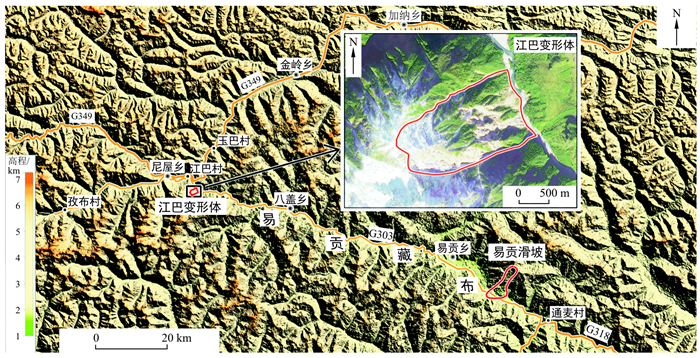
图 1 江巴变形体位置示意图
Figure 1. Schematic diagram of the location of the Jiangba deformed body

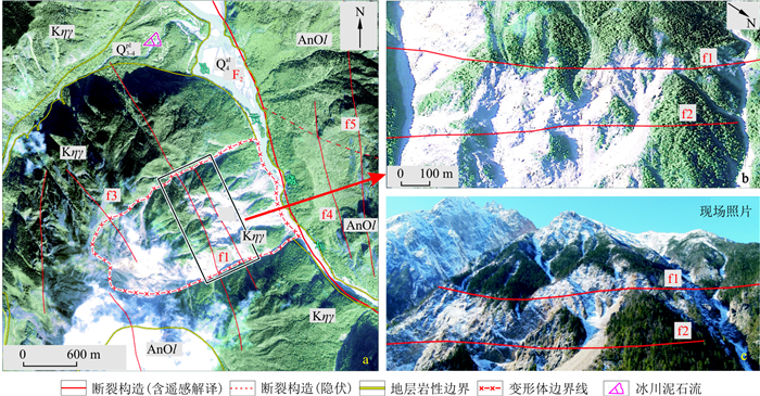
图 2 研究区地质构造分布图
AnOl.前奥陶纪雷龙库岩组石英岩; C2P1l.石炭纪-二叠纪来姑组石英砂岩; Kηγ.晚燕山期二长花岗岩; Eηγ.喜山期二长花岗岩; Q3gl.晚更新世冰积物; Q4al.全新世冲积物; Q4pl.全新世洪积物;下同
Figure 2. Distribution of geological formations in the study area

图 3 巴变形体地质遥感解译图(a, b)及照片(c)
Q3-4pl.上更新统-全新统洪积物; F2/f2.断裂构造及次级构造编号
Figure 3. Geological remote sensing interpretation map (a, b) and photos (c) of the Jiangba deformed body

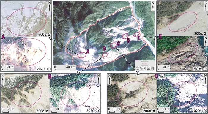
图 4 江巴变形体遥感动态监测影像
Figure 4. Remote sensing dynamic monitoring image of the Jiangba deformed body

图 5 江巴变形体局部形变对比图
Figure 5. Comparison of the local deformation of the Jiangba deformed body

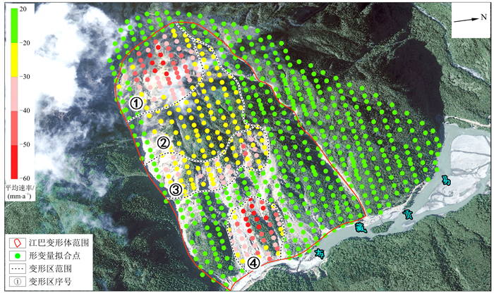
图 6 江巴变形体InSAR监测形变速率及分区图(2016.10-2020.11)
Figure 6. InSAR monitoring deformation rate and zoning map of the Jiangba deformed body
表 1 江巴变形体遥感动态监测影像数据一览
Table 1. List of remote sensing dynamic monitoring image data of the Jiangba deformed body
序号 1 2 3 4 5 6 数据时相 1988.10 1994.04 2000.09 2006.05 2015.11 2020.10 影像类型 TM5 TM5 ETM7 Quickbird GF-2 GF-2 分辨率/m 30 30 15 0.6 0.8 0.8  下载: 导出CSV
-
[1] 刘伟. 西藏易贡巨型超高速远程滑坡地质灾害链特征研析[J]. 中国地质灾害与防治学报, 2002, 13(3): 11-20. https://www.cnki.com.cn/Article/CJFDTOTAL-ZGDH200203001.htmLiu W. Study on the characteristics of huge scale-super highspeed-long distance landslide chain in Yigong, Tibet[J]. The Chinese Journal of Geological Hazard and Control, 2002, 13(3): 11-20(in Chinese with English abstract). https://www.cnki.com.cn/Article/CJFDTOTAL-ZGDH200203001.htm [2] 王哲, 赵超英, 刘晓杰, 等. 西藏易贡滑坡演化光学遥感分析与InSAR形变监测[J]. 武汉大学学报: 信息科学版, 2021, 46(10): 1569-1578. https://www.cnki.com.cn/Article/CJFDTOTAL-WHCH202110015.htmWang Z, Zhao C Y, Liu X J, et al. Evolution analysis and deformation monitoring of Yigong landslide in Tibet with optical remote sensing and InSAR[J]. Geomatics and Information Science of Wuhan University, 2021, 46(10): 1569-1578(in Chinese with English abstract). https://www.cnki.com.cn/Article/CJFDTOTAL-WHCH202110015.htm [3] 黄勇, 孟祥连, 胡卸文, 等. 雅安至林芝交通廊道重大工程地质问题与对策研究[J]. 工程地质学报, 2021, 29(2): 307-325.Huang Y, Meng X L, Hu X W, et al. Major engineering geological problems and countermeasures along traffic corridor from Ya'an to Nyingchi[J]. Journal of Engineering Geology, 2021, 29(2): 307-325(in Chinese with English abstract). [4] 袁浩, 郭长宝, 吴瑞安, 等. 西藏易贡高位远程滑坡研究进展与展望[J/OL]. 地质通报. http://kns.cnki.net/kcms/detail/11.4648.P.20211227.1821.004.html .Yuan H, Guo C B, Wu R A, et al. Research progress and prospects of the giant Yigong long run-out landslide, Tibetan Plateau, China[J/OL]. Geological Bulletin of China.http://kns.cnki.net/kcms/detail/11.4648.P.20211227.1821.004.html (in Chinese with English abstract).[5] 刘文, 王猛, 宋班, 等. 基于光学遥感技术的冰崩隐患遥感调查及链式结构研究: 以西藏自治区藏东南地区为例[J]. 自然资源遥感, 2022, 34(1): 265-276. https://www.cnki.com.cn/Article/CJFDTOTAL-GTYG202201030.htmLiu W, Wang M, Song B, et al. Surveys and chain structure study of potential hzzards of ice avalanches based om optical remote sensing technology: A case study of southeast Tibet[J]. Remote Sensing for Natural Resources, 2022, 34(1): 265-276(in Chinese with English abstract). https://www.cnki.com.cn/Article/CJFDTOTAL-GTYG202201030.htm [6] 黄润秋, 裴向军, 李天斌. 汶川地震触发大光包巨型滑坡基本特征及形成机理分析[J]. 工程地质学报, 2008, 16(6): 730-741. https://www.cnki.com.cn/Article/CJFDTOTAL-GCDZ200806002.htmHuang R Q, Pei X J, Li T B. Basic characteristics and formation mechanism of the largest scale landslide at Daguangbao occurred during the Wenchuan Earthquake[J]. Journal of Engineering Geology, 2008, 16(6): 730-741(in Chinese with English abstract). https://www.cnki.com.cn/Article/CJFDTOTAL-GCDZ200806002.htm [7] 殷跃平. 斜倾厚层山体滑坡视向滑动机制研究: 以重庆武隆鸡尾山滑坡为例[J]. 岩石力学与工程学报, 2010, 29(2): 217-226. https://www.cnki.com.cn/Article/CJFDTOTAL-YSLX201002002.htmYin Y P. Mechanism of apparent dip slide of inclined bedding rockslide: A case study of Jiweishan rockslide in Wulong, Chongqing[J]. Chinese Journal of Rock Mechanics and Engineering, 2010, 29(2): 217-226(in Chinese with English abstract). https://www.cnki.com.cn/Article/CJFDTOTAL-YSLX201002002.htm [8] Baum R L, Coe J A, Godt J W, et al. Regional landslide-hazard assessment for Seattle, Washington, UGA[J], Landslide, 2005, 4: 266-279. http://www.cosis.net/members/meetings/abstracts/file.php/20/47701/jpdf/EGU05-J-02190.pdf [9] 许强, 汤明高, 徐开祥, 等. 滑坡时空演化规律及预警预报研究[J]. 岩石力学与工程学报, 2008, 27(6): 1104-1112. https://www.cnki.com.cn/Article/CJFDTOTAL-YSLX200806005.htmXu Q, Tang M G, Xu K X, et al. Research on space-time evolution lows and early warning-prediction of landslides[J]. Chinese Journal of Rock Mechanics and Engineering, 2008, 27(6): 1104-1112(in Chinese with English abstract). https://www.cnki.com.cn/Article/CJFDTOTAL-YSLX200806005.htm [10] 张衡, 徐团伟, 裴顺平, 等. 利用分布式光纤声传感设备开展青藏高原易贡湖浅层结构探测[J]. 地学前缘, 2021, 28(6): 227-234. https://www.cnki.com.cn/Article/CJFDTOTAL-DXQY202106021.htmZhang H, Xu T W, Pei S P, et al. An application of the distributed acoustic sensing in the Yigong Lake, Tibet[J]. Earth Science Frontiers, 2021, 28(6): 227-234(in Chinese with English abstract). https://www.cnki.com.cn/Article/CJFDTOTAL-DXQY202106021.htm [11] 李澜宇. 基于多源遥感数据的易贡藏布流域冰川变化与物质平衡研究[D]. 南京: 南京大学, 2017.Li L Y. Study on variation and mass balance estimations of glacier in Yigong Zangbu Basin, Tibet using multi-source remote sensing data[D]. Nanjing: Nanjing University, 2017(in Chinese with English abstract). [12] 涂继耀, 季建清, 钟大赉, 等. 帕隆藏布江中游地壳剥露特征[J]. 地质科技通报, 2022, 41(4): 292-300. doi: 10.19509/j.cnki.dzkq.2021.0260Tu J Y, Ji J Q, Zhong D L, et al. Crust erosion characteristics in the middle reach of the Purlungtsangpo River[J]. Bulletin of Geological Science and Technology, 2022, 41(4): 292-300(in Chinese with English abstract). doi: 10.19509/j.cnki.dzkq.2021.0260 [13] 李生伟, 韦梅华, 刘强. 西藏阿里仲巴地块公珠错片麻岩锆石U-Pb年代学及其地质意义[J]. 地质科技通报, 2023, 42(1): 191-203. doi: 10.19509/j.cnki.dzkq.2021.0085Li S W, Wei M H, Liu Q. Zircon U-Pb geochronology of the Gongzhu Cogneiss in the Zhongba Block from Ali, Tibet and its geological significance[J]. Bulletin of Geological Science and Technology, 2023, 42(1): 191-203(in Chinese with English abstract). doi: 10.19509/j.cnki.dzkq.2021.0085 [14] 万佳威, 褚宏亮, 李滨, 等. 西藏嘉黎断裂带沿线高位链式地质灾害发育特征分析[J]. 中国地质灾害与防治学报, 2021, 32(3): 51-60. https://www.cnki.com.cn/Article/CJFDTOTAL-ZGDH202103007.htmWan J W, Chu H L, Li B, et al. Characteristics, types, main causes and development of high-position geohazard chains along the Jiali fault zone, Tibet, China[J]. The Chinese Journal of Geological Hazard and Control, 2021, 32(3): 51-60(in Chinese with English abstract). https://www.cnki.com.cn/Article/CJFDTOTAL-ZGDH202103007.htm [15] 黄健, 贺子城, 黄祥, 等. 基于地貌特征的滑坡堰塞坝形成敏感性研究[J]. 地质科技通报, 2021, 40(5): 253-262. doi: 10.19509/j.cnki.dzkq.2021.0040Huang J, He Z C, Huang X, et al. Formation sensitivitf of landslide dam based on geomorphic chcharacteristics[J]. Bulletin of Geological Science and Technology, 2021, 40(5): 253-262(in Chinese with English abstract). doi: 10.19509/j.cnki.dzkq.2021.0040 [16] 李婉秋. 基于Sentinel-1数据的SBAS-InSAR技术在地表形变监测中的研究[D]. 成都: 成都理工大学, 2018.Li W Q. A research of SBAS-InSAR technology based on Sentinel-1 data in surface deformation monitoring[D]. Chengdu: Chengdu University of Technology, 2018(in Chinese with English abstract). [17] 闫怡秋, 郭长宝, 张永双, 等. 基于SBAS-InSAR技术的西藏雄巴古滑坡变形特征[J]. 地质学报, 2021, 95(11): 3556-3570. https://www.cnki.com.cn/Article/CJFDTOTAL-DZXE202111027.htmYan Y Q, Guo C B, Zhang Y S, et al. Study on the deformation characteristics of Xiongba ancient landslide based on SBAS-InSAR methed, Tibet, China[J]. Acta Geologica Sinica, 2021, 95(11): 3556-3570(in Chinese with English abstract). https://www.cnki.com.cn/Article/CJFDTOTAL-DZXE202111027.htm [18] 董佳慧, 牛瑞卿, 亓梦茹, 等. InSAR技术和孕灾背景指标相结合的地灾隐患识别[J]. 地质科技通报, 2022, 41(2): 187-196. doi: 10.19509/j.cnki.dzkq.2022.0024Dong J H, Niu R Q, Qi M R, et al. Identification of geological azards based on the combination of InSAR technology and disaster background indicators[J]. Bulletin of Geological Science and Technology, 2022, 41(2): 187-196(in Chinese with English abstract). doi: 10.19509/j.cnki.dzkq.2022.0024 [19] 李振洪, 宋闯, 余琛, 等. 卫星雷达遥感在滑坡灾害探测和监测中的应用: 挑战与对策[J]. 武汉大学学报: 信息科学版, 2019, 44(7): 967-979. https://www.cnki.com.cn/Article/CJFDTOTAL-WHCH201907003.htmLi Z H, Song C, Yu C, et al. Application of satellite radar remote sensing to landslite detection and monitoring: Challenges and solutions[J]. Geomatics and Information Science of Wuhan University, 2019, 44(7): 967-979(in Chinese with English abstract). https://www.cnki.com.cn/Article/CJFDTOTAL-WHCH201907003.htm [20] 仝德富, 谭飞, 苏爱军, 等. 基于多源数据的谭家湾滑坡变形机制及稳定性评价[J]. 地质科技通报, 2021, 40(4): 162-170. doi: 10.19509/j.cnki.dzkq.2021.0432Tong D F, Tan F, Su A J, et al. Deformation mechanism and stability evaluation of Tanjiawan landslide based on multi-sources datas[J]. Bulletin of Geological Science and Technology, 2021, 40(4): 162-170(in Chinese with English abstract). doi: 10.19509/j.cnki.dzkq.2021.0432 -

 下载:
下载:


 点击查看大图
计量
- 文章访问数: 613
- PDF下载量: 43
- 被引次数: 0
