


Spatial heterogeneity characteristics of soil-epikarst thickness in a typical karst dolomite small watershed
-
摘要:
土壤-表层岩溶带厚度是喀斯特地球关键带的关键指标,明确其空间异质性特征对于理解地球关键带结构演化机理以及评估水源涵养功能具有重要意义。在广西环江木连小流域1.4 km2范围内,通过高密度电法(ERT)探测45条样线,共获取1 731个样点的土壤-表层岩溶带厚度及环境因子数据资料,研究了土壤和表层岩溶带厚度的空间分布格局及其影响因素。结果表明,土壤和表层岩溶带厚度平均值分别为1.15 m和6.44 m,且分别呈现强变异程度和中等变异程度。地统计分析结果表明球状模型和指数模型分别可以反映土壤和表层岩溶带的空间结构特征。土壤厚度呈现中等空间自相关性,变程长,空间连续性好;而表层岩溶带呈现强烈的空间自相关性,变程短,空间依赖性强。土壤厚度受到环境因子(地形湿度指数、垂直曲率、曲率、坡向、坡度、高程、覆盖度、出露基岩率和植被归一化指数)的多重影响,而表层岩溶带厚度受部分环境因子影响的同时,与土壤厚度和植被类型的相关性更高。研究结果有助于喀斯特区土壤-表层岩溶带演化机理认识,并为土壤-表层岩溶带厚度的空间预测提供科学依据。
Abstract:Objective The thickness of soilepikarst is an important index affecting the hydrological process of critical zones. The spatial heterogeneity is critical understanding the structural evolution mechanism of the key zones of the Earth and the water conservation function of the key zones of the Earth.
Methods Based on the 1.4 km2 area of the Mulian catchment in Huanjiang, Guangxi, the 1 731 soil-epikarst thickness samples were obtained through electrical resistivity tomography (ERT) with 45 sampling lines.The spatial distribution pattern of soil and epikarst thickness and its influencing factors were investigated. The results showed that the average thickness of soil and epikarst was 1.15 m and 6.44 m with strong and medium variance, respectively.
Results The results of geostatistical analysis indicated that the spherical model and exponential model could reflect the spatial structure characteristics of soil and epikarst thickness, respectively. Soil thickness showed moderate spatial autocorrelation, a long range and good spatial continuity. However, the epikarst presented strong spatial autocorrelation and spatial dependence with a short range. Soil thickness was affected by multiple environmental factors (topographic wetness index, vertical curvature, curvature, aspect, slope, elevation, coverage, outcrop ratio and NDVI), while the thickness of epikarst was more affected by soil thickness and vegetation type.
Conclusion These results are helpful for understanding the evolution of the soil-epikarst zone and provide a scientific basis for the spatial prediction of soil-epikarst thickness in karst areas.
-
Key words:
- karst critical zone /
- spatial heterogeneity /
- soil-epikarst /
- vegetation type /
- dolomite small watershed
-

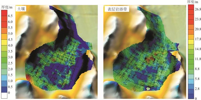
图 3 研究区土壤-表层岩溶带厚度空间分布图
Figure 3. Distribution of soil and epikarst thickness in the study area

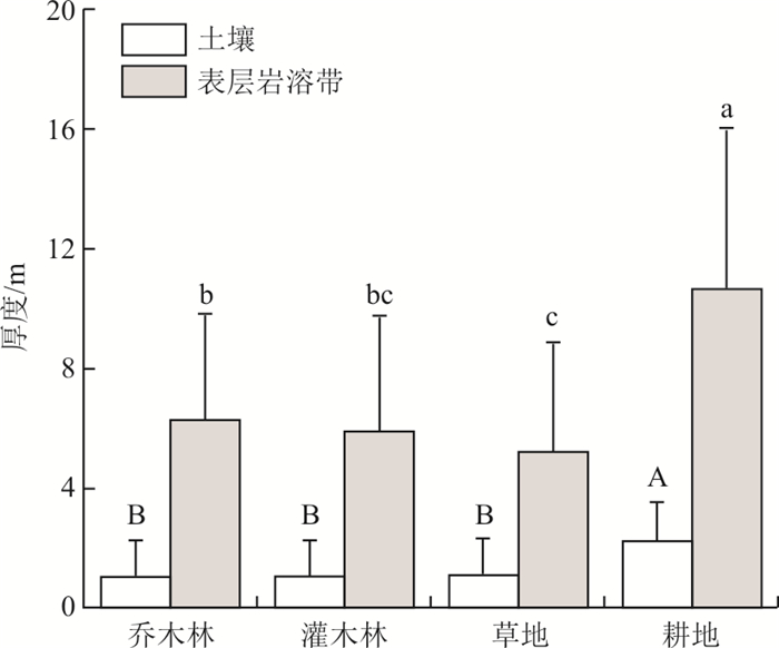
图 4 不同植被类型下的土壤-表层岩溶带厚度
注:差异显著性检验方法为最小显著性差异法(least significant difference, 简称LSD);A,B表示不同植被类型下的土壤厚度差异;a, b, c表示不同植被类型下的表层岩溶带厚度差异
Figure 4. Soil-epikarst thickness under different land cover types
表 1 基岩化学成分组成
Table 1. Chemical composition of bedrock
样点 灼烧减量 SiO2 Al2O3 TFe2O3 CaO MgO K2O Na2O TiO2 P2O5 MnO wB/% 东南坡 46.57 0.67 0.16 0.09 30.91 21.54 0.009 8 0.03 0.02 0.008 3 0.003 2 洼地 46.59 0.48 0.32 0.06 31.15 21.54 0.006 9 0.02 0.06 0.006 5 0.004 7 西北坡 46.49 0.36 0.26 0.04 32.19 20.45 0.005 3 0.03 0.03 0.006 6 0.002 7  下载: 导出CSV
表 2 土壤和表层岩溶带厚度的描述性统计
Table 2. Descriptive analysis and normal distribution test of the epikarst thickness
样本数 最小值/m 最大值/m 平均值/m 标准差 变异系数 偏度 峰度 土壤厚度 1 731 0 6.4 1.15 1.3 1.13 1.04 0.36 表层岩溶带厚度 1 731 0.5 26.8 6.44 4.37 0.68 1.36 2.33
下载: 导出CSV
表 3 土壤和表层岩溶带厚度的半变异函数模型及其参数
Table 3. Types and parameters of the semivariogram model for the soil-epikarst thickness
模型 块金值C0 基台值C0+C 块金值/基台值C0/(C0+C) 变程/m 决定系数R2 土壤厚度 球状模型 0.8 1.77 0.45 201 0.877 表层岩溶带厚度 指数模型 4.8 20.32 0.24 153 0.725
下载: 导出CSV
表 4 土壤-表层岩溶带厚度与地形-环境因子的相关系数
Table 4. Correlation coefficients between soil-epikarst thickness and terrain-environmental factors
地形湿度指数 垂向曲率 平面曲率 曲率 坡向 坡度 高程 覆盖度 出露基岩率 植被归一化指数 土壤厚度 0.149** -0.080** 0.052 -0.070** -0.087** -0.281** -0.320** -0.206** -0.377** -0.082** 表层岩溶带厚度 0.163** -0.014 0.034 -0.031 0.010 -0.151** -0.220** -0.255** -0.301** -0.275** 注:**表示在0.01水平上显著相关
下载: 导出CSV
表 5 土壤和表层岩溶带厚度回归方程参数
Table 5. Parameters of the regression equations of the soil-epikarst thickness
常数 地形湿度指数 垂向曲率 曲率 坡向 坡度 高程 覆盖度 出露基岩率 植被归一化指数 R2 P 土壤厚度 4.023 -0.004 0.334 -0.125 0.001 -0.029 -0.003 -0.009 -0.037 -0.219 0.215 <0.001 表层岩溶带厚度 22.33 0.118 — — — -0.006 -0.017 -0.043 -0.089 -13.63 0.177 <0.001
下载: 导出CSV
表 6 基于植被类型和土壤厚度划分的土表层岩溶带厚度回归方程参数
Table 6. Parameters of the regression equations of the epikarst thickness based on soil thickness and land cover
常数 地形湿度指数 坡度 高程 覆盖度 出露基岩率 植被归一化指数 土壤厚度 虚拟参数 R2 P D1 D2 D3 表层岩溶 11.932 0.063 0.001 -0.004 -0.021 -0.082 -2.503 — -0.398 -1.569 2.666 0.232 <0.001 带厚度 10.558 0.075 0.011 -0.002 -0.020 -0.063 -3.800 0.571 -0.340 -1.395 2.263 0.253 <0.001
下载: 导出CSV
-
[1] 吕玉香, 胡伟, 杨琰. 岩溶关键带水循环过程研究进展[J]. 水科学进展, 2019, 30(1): 124-138.LV Y X, HU W, YANG Y. Research process of hydrological cycle in karst critial zone[J]. Advance in Water Science, 2019, 30(1): 124-138. (in Chinese with English abstract) [2] 张君, 付智勇, 陈洪松, 等. 西南喀斯特白云岩坡地土壤-表层岩溶带结构及水文特征[J]. 应用生态学报, 2021, 32(6): 2107-2118.ZHANG J, FU Z Y, CHEN H S, et al. Soil-epikarst structures and their hydrological characteristics on dolomite slopes in karst region of Southwest China[J]. Chinese Journal of Applied Ecology, 2021, 32(6): 2107-2118. (in Chinese with English abstract) [3] YANG Q Y, ZHANG F W, JIANG Z C, et al. Relationship between soil depth and terrain attributes in karst region in Southwest China[J]. Journal of Soils and Sediments, 2014, 14(9): 1568-1576. doi: 10.1007/s11368-014-0904-6 [4] LU Y Y, LIU F, ZHAO Y G, et al. An integrated method of selecting environmental covariates for predictive soil depth mapping[J]. Journal of Integrative Agriculture, 2019, 18(2): 57-71. [5] HAN X L, LIU J T, MITR S, et al. Selection of optimal scales for soil depth prediction on headwater hillslopes: A modeling approach[J]. Catena, 2018, 163: 257-275. doi: 10.1016/j.catena.2017.12.026 [6] JIANG Z C, LIAN Y Q, QIN X Q. Rocky desertification in Southwest China: Impacts, causes, and restoration[J]. Earth Science Reviews, 2014, 132: 1-12. doi: 10.1016/j.earscirev.2014.01.005 [7] 袁道先. 我国西南岩溶石山的环境地质问题[J]. 大自然探索, 1996, 15(4): 21- 23.YUAN D X. On the environmental and geologic problems of karst mountains and rocks in the Southwest China[J]. Exploration of Nature, 1996, 15(4): 21-23. (in Chinese with English abstract) [8] 王苗苗, 陈洪松, 付同刚, 等. 典型喀斯特小流域不同植被类型间土壤养分的差异性及其空间预测方法[J]. 应用生态学报, 2016, 27(6): 1759-1766.WANG M M, CHEN H S, FU T G, et al. Differences of soil nutrients among different vegetation types and their spatial prediction in a small typical karst catchment[J]. Chinese Journal of Applied Ecology, 2016, 27(6): 1759-1766. (in Chinese with English abstract) [9] ZHANG Y, XU X, LI Z, et al. Modelling soil thickness using environmental attributes in karst watersheds[J]. Catena, 2022, 212: 106053. doi: 10.1016/j.catena.2022.106053 [10] ZHANG S, LIU G, CHEN S L, et al. Assessing soil thickness in a black soil watershed in Northeast China using random forest and field observations[J]. International Soil and Water Conservation Research, 2021, 9(1): 49-57. doi: 10.1016/j.iswcr.2020.09.004 [11] FORD D, WILLIAMS P D. Karst hydrogeology and geomorphology[M]. Chichester: John Wiley & Sons, 2013. [12] 袁道先. 论岩溶环境系统[J]. 中国岩溶, 1988, 7(8): 9-16.YAN D X. On the karst environmental system[J]. Carsologica Sinica, 1988, 7(8): 179-186. (in Chinese with English abstract) [13] 王焕. 贵州白云岩与石灰岩地区水资源特征及开发利用对策研究[D]. 贵阳: 贵州师范大学, 2020.WANG H. Research on the features, and strategies of development and utilization of the water resource in dolomite and limestone areas in Guizhou Province[D]. Guiyang: Guizhou Normal University, 2020. (in Chinese with English abstract) [14] MENG Q, WANG S, FU Z, et al. Soil types determine vegetation communities along a toposequence in a dolomite peak-cluster depression catchment[J]. Plant and Soil, 2022, 475: 5-22. doi: 10.1007/s11104-022-05308-5 [15] 黄昌勇. 面向21世纪课程教材: 土壤学[M]. 北京: 中国农业出版社, 2000.HUANG C Y. Textbook series for 21st century: Pedology[M]. Beijing: China Agriculture Press, 2000. (in Chinese) [16] 廖双斌. 典型岩溶山地土壤厚度的空间插值模型应用研究[D]. 昆明: 昆明理工大学, 2015.LIAO S B. Application of spatial interpolation model for soil thickness in typical karst mountains[D]. Kunming: Kunming University of Science and Technology, 2015. (in Chinese with English abstract) [17] 周运超, 罗美. 喀斯特小流域土壤厚度的影响因素[J]. 山地农业生物学报, 2017, 36(3): 1-5.ZHOU Y C, LUO M. Influencing factors of soil thickness in karst small watershed[J]. Journal of Mountain Agriculture and Biology, 2017, 36(3): 1-5. (in Chinese with English abstract) [18] 尹亮, 崔明, 周金星, 等. 岩溶高原地区小流域土壤厚度的空间变异特征[J]. 中国水土保持科学, 2013, 11(1): 51-58.YIN L, CUI M, ZHOU J X, et al. Spatial variability of soil thickness in a small watershed of karst plateau[J]. Science of Soil and Water Conservation, 2013, 11(1): 51-58. (in Chinese with English abstract) [19] LI X C, LUO J H, JIN X L, et al. Improving soil thickness estimations based on multiple environmental variables with stacking ensemble methods[J]. Remote Sensing, 2020, 12(21): 3609. doi: 10.3390/rs12213609 [20] NIE Y P, DING Y L, ZHANG H L, et al. Comparison in woody species composition between rocky outcrop and nearby matrix vegetation on degraded karst hillslope of Southwest China[J]. Journal of Forestry Research, 2019, 30(3): 911-920. doi: 10.1007/s11676-018-0682-x [21] WILLIAMS P W. The role of the epikarst in karst and cave hydrogeology: A review[J]. Int. J. Speleol., 2008, 37(1): 1-10. doi: 10.5038/1827-806X.37.1.1 [22] MAHER K, CHAMBERLAIN C P. Hydrologic regulation of chemical weathering and the geologic carbon cycle[J]. Science, 2014, 343: 1502-1504. doi: 10.1126/science.1250770 [23] CAO M, LEI J Q, HE Q F, et al. Rainfall-driven and hydrologically controlled variations in cave CO2 sources and dynamics: Evidence from monitoring soil CO2, stream flow and cave CO2[J]. J. Hydrol., 2021, 595: 126060. doi: 10.1016/j.jhydrol.2021.126060 [24] 张志才, 陈喜, 刘金涛, 等. 喀斯特山体地形对表层岩溶带发育的影响: 以陈旗小流域为例[J]. 地球与环境, 2012, 40(2): 137-143.ZHANG Z C, CHEN X, LIU J T, et al. Influence of topography on epikarst in karst mountain areas: A case study of Chenqi catchment[J]. Earth and Environment, 2012, 40(2): 137-143. (in Chinese with English abstract) [25] BAKALOWICZ M. Epikarst processes, treatise on geomorphology[M]. San Diego: Academic Press, 2013. [26] SCHWINNING S. A critical question for the critical zone: How do plants use rock water?[J]. Plant Soil, 2020, 454: 49-56. doi: 10.1007/s11104-020-04648-4 [27] NIE Y, CHEN H, WANG K, et al. Water source utilization by woody plants growing on dolomite outcrops and nearby soils during dry seasons in karst region of Southwest China[J]. Journal of Hydrology, 2012, 420: 264-274. [28] 罗维均, 杨开萍, 王彦伟, 等. 喀斯特地区不同岩土组构对岩溶碳通量的影响[J]. 地质科技通报, 2022, 41(3): 208-214. doi: 10.19509/j.cnki.dzkq.2022.0088LUO W J, YANG K P, WANG Y W, et al. Influence of different rock-soil fabrics on carbonate weathering carbon sink flux in karst regions[J]. Bulletin of Geological Science and Technology, 2022, 41(3): 208-214. (in Chinese with English abstract) doi: 10.19509/j.cnki.dzkq.2022.0088 [29] 马剑飞, 付昌昌, 张春潮, 等. 康定北部高原构造岩溶发育特征与地下水径流带识别[J]. 地质科技通报, 2022, 41(1): 288-299. doi: 10.19509/j.cnki.dzkq.2022.0017MA J F, FU C C, ZHANG C C, et al. Plateau tectonic karst development characteristics and underground conduits identification in the northern part of Kangding[J]. Bulletin of Geological Science and Technology, 2022, 41(1): 288-299. (in Chinese with English abstract) doi: 10.19509/j.cnki.dzkq.2022.0017 [30] HU K, CHEN H S, NIE Y P, et al. Seasonal recharge and mean residence times of soil and epikarst water in a small karst catchment of Southwest China[J]. Scientific Reports, 2015, 5: 10215. doi: 10.1038/srep10215 [31] WANG F, CHEN H, LIAN J, et al. Seasonal recharge of spring and stream waters in a karst catchment revealed by isotopic and hydrochemical analyses[J]. J. Hydrol., 2020, 591: 125595. doi: 10.1016/j.jhydrol.2020.125595 [32] MCCORMICK E, DRALLE D, HAHM W, et al. Widespread woody plant use of water stored in bedrock[J]. Nature, 2021, 597: 225-229. doi: 10.1038/s41586-021-03761-3 [33] 邓艳. 西南典型峰丛洼地岩溶关键带植被-表层岩溶水的耦合过程[D]. 武汉: 中国地质大学(武汉), 2018.DENG Y. Coupling process between vegetation and epikarst water in karst critical zone, southwest typical peak-cluster depression area[D]. Wuhan: China University of Geosciences(Wuhan), 2018. (in Chinese with English abstract) -

 下载:
下载:


 点击查看大图
计量
- 文章访问数: 663
- PDF下载量: 63
- 被引次数: 0

