Landslide susceptibility assessment in the alpine and canyon areas on the basis of ascending and descending InSAR data
-
摘要:
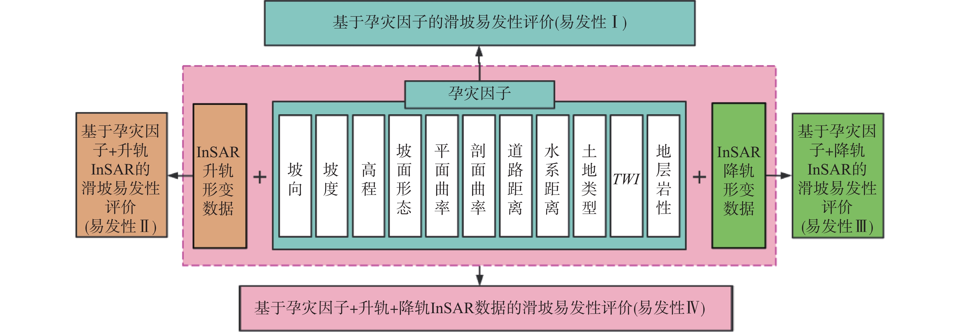
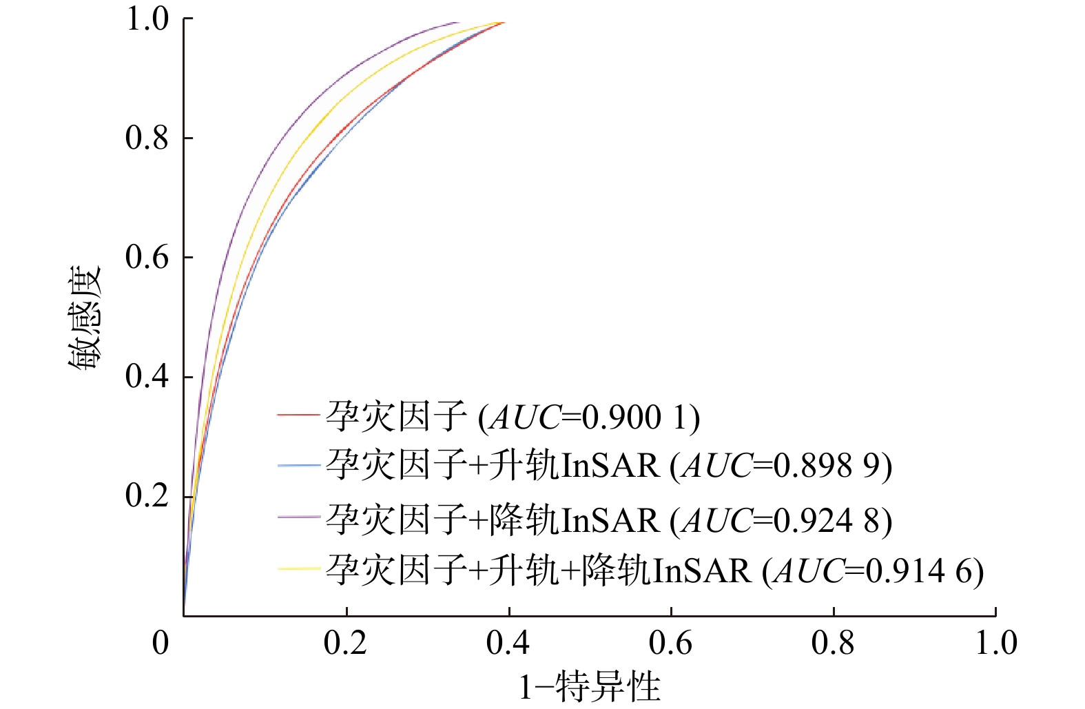
近年来,反映地表变形因子的合成孔径雷达干涉测量InSAR(interferometric synthetic aperture radar)数据被逐渐引入到滑坡易发性评价中。然而这些研究未考虑SAR影像差异,特别是在高山峡谷区InSAR升、降轨成像效果差别大,对地表变形的反映存在较大误差。为了在滑坡易发性评价中更加准确地使用InSAR数据,选择象鼻岭水电站库区作为研究区,经过指标因子相关性分析后,选择了和高山峡谷区滑坡发生相关的11个孕灾因子与升、降轨InSAR变形数据组合进行滑坡易发性评价。比较是否使用变形数据和使用不同变形数据之间的结果发现,在易发性评价中补充采样点较稀疏的升轨数据反而会降低易发性评价精度,补充采样点较多的降轨数据能一定程度上提高2.7%的易发性精度(
AUC $= $0.9248 )。研究表明,InSAR变形数据作为因子引入滑坡易发性评价中会影响评价结果,在高山峡谷区选用合适的InSAR变形数据可提高易发性评价精度。Abstract:Objective In recent years, Interferometric Synthetic Aperture Radar (InSAR) data, which reflect surface deformation, have increasingly been integrated into landslide susceptibility assessments. However, previous studies have not adequately addressed the variability in SAR images, particularly in alpine and canyon regions where the imaging characteristics of InSAR ascending and descending passes differ significantly, leading to substantial errors in surface deformation measurements.
Methods This study selected the reservoir area of Xiangbiling Hydropower Station as the research site. After conducting a correlation analysis of influencing factors, 11 influencing factors and InSAR deformation data pertinent to landslides in alpine and canyon areas were chosen for landslide susceptibility evaluation.
Results Comparisons between using different deformation datasets revealed that incorporating sparse ascending-pass data from sampling points decreases the accuracy of landslide susceptibility assessment. Conversely, utilizing descending-pass SAR data, which includes a higher density of sampling points, improved the accuracy by 2.7% (
AUC =0.9248 ).Conclusion The inclusion of InSAR deformation data as a influencing factor in landslide susceptibility assessment significantly influences the evaluation outcomes. Therefore, it is crucial to select appropriate InSAR deformation data to enhance the accuracy of susceptibility assessments.
-
表 1 Sentinel-1A卫星基本参数
Table 1. Sentinel-1A data basic parameters
主要参数 基本数据 波长/cm 5.6 波段 C波段 轨道方向 升/降轨 重访周期/d 12 入射角/(°) 39.31,39.24 成像方式 宽幅成像(IW) 极化方式 垂直单极化(VV) 表 2 滑坡信息量差异值占比
Table 2. Proportion of landslide information difference values
编号 信息量变化 滑坡面所占栅格数 栅格总数 有效增加指数/% 易发性Ⅱ−Ⅰ 增加 2251 59371 3.79 不变 5162 145843 减少 353 9985 易发性Ⅲ−Ⅰ 增加 475 7044 6.74 不变 5740 162564 减少 1551 45591 易发性Ⅳ−Ⅰ 增加 1766 28994 6.09 不变 5718 170218 减少 282 15987 表 3 InSAR变形数据因子信息量值
Table 3. InSAR deformation data factor information values
数据类型 变形速率/(mm·a−1)分段 栅格数 滑坡栅格数 信息量 升轨 (−87.06,−26.47] 20702 473 −0.66 (−26.47,−9.37] 52930 1798 −0.09 (−9.37,4.88] 75328 2618 −0.05 (4.88,21.98] 52714 2132 0.16 (21.98,94.68] 13525 741 0.60 降轨 (−124.35,−22.91] 14895 1366 1.35 (−22.91,−4.83] 55591 2945 0.55 (−4.83,9.22] 76992 1896 −0.55 (9.22,27.30] 52884 1225 −0.63 (27.30,131.76] 14837 330 −0.69 -
[1] GUZZETTI F,REICHENBACH P,ARDIZZONE F,et al. Estimating the quality of landslide susceptibility models[J]. Geomorphology,2006,81(1/2):166-184. [2] 黄润秋. 20世纪以来中国的大型滑坡及其发生机制[J]. 岩石力学与工程学报,2007,26(3):433-454.HUANG R Q. Large-scale landslides and their sliding mechanisms in China since the 20th century[J]. Chinese Journal of Rock Mechanics and Engineering,2007,26(3):433-454. (in Chinese with English abstract [3] TANG H M,WASOWSKI J,JUANG C H. Geohazards in the three Gorges Reservoir area,China:Lessons learned from decades of research[J]. Engineering Geology,2019,261:105267. doi: 10.1016/j.enggeo.2019.105267 [4] XIE X X,LI D Y,MIAO F S,et al. The Kangjiapo landslide in Wanzhou district,Chongqing City:Reactivation of a deep-seated colluvial landslide in the Three Gorges Reservoir[J]. Bulletin of Engineering Geology and the Environment,2023,82(10):386. doi: 10.1007/s10064-023-03404-z [5] 许强,董秀军,李为乐. 基于天−空−地一体化的重大地质灾害隐患早期识别与监测预警[J]. 武汉大学学报(信息科学版),2019,44(7):957-966.XU Q,DONG X J,LI W L. Integrated space-air-ground early detection,monitoring and warning system for potential catastrophic geohazards[J]. Geomatics and Information Science of Wuhan University,2019,44(7):957-966. (in Chinese with English abstract [6] GUZZETTI F,REICHENBACH P,CARDINALI M,et al. Probabilistic landslide hazard assessment at the basin scale[J]. Geomorphology,2005,72(1/2/3/4):272-299. [7] FELL R,COROMINAS J,BONNARD C,et al. Guidelines for landslide susceptibility,hazard and risk zoning for land use planning[J]. Engineering Geology,2008,102(3/4):85-98. [8] 黄发明,叶舟,姚池,等. 滑坡易发性预测不确定性:环境因子不同属性区间划分和不同数据驱动模型的影响[J]. 地球科学,2020,45(12):4535-4549.HUANG F M,YE Z,YAO C,et al. Uncertainties of landslide susceptibility prediction:Different attribute interval divisions of environmental factors and different data-based models[J]. Earth Science,2020,45(12):4535-4549. (in Chinese with English abstract [9] 李文彬,范宣梅,黄发明,等. 不同环境因子联接和预测模型的滑坡易发性建模不确定性[J]. 地球科学,2021,46(10):3777-3795.LI W B,FAN X M,HUANG F M,et al. Uncertainties of landslide susceptibility modeling under different environmental factor connections and prediction models[J]. Earth Science,2021,46(10):3777-3795. (in Chinese with English abstract [10] 何书,鲜木斯艳·阿布迪克依木,胡萌,等. 基于自组织特征映射网络−随机森林模型的滑坡易发性评价:以江西大余县为例[J]. 中国地质灾害与防治学报,2022,33(1):132-140.HE S,ABUDIKEYIMU X,HU M,et al. Evaluation on landslide susceptibility based on self-organizing feature map network and random forest model:A case study of Dayu County of Jiangxi Province[J]. The Chinese Journal of Geological Hazard and Control,2022,33(1):132-140. (in Chinese with English abstract [11] 吴树仁,石菊松,张春山,等. 地质灾害风险评估技术指南初论[J]. 地质通报,2009,28(8):995-1005.WU S R,SHI J S,ZHANG C S,et al. Preliminary discussion on technical guideline for geohazard risk assessment[J]. Geological Bulletin of China,2009,28(8):995-1005. (in Chinese with English abstract [12] 许冲,戴福初,姚鑫,等. GIS支持下基于层次分析法的汶川地震区滑坡易发性评价[J]. 岩石力学与工程学报,2009,28(增刊2):3978-3985.XU C,DAI F C,YAO X,et al. GIS-Based landslide susceptibility assessment using analytical hierarchy process in Wenchuan earthquake region[J]. Chinese Journal of Rock Mechanics and Engineering,2009,28(S2):3978-3985. (in Chinese with English abstract [13] ERMINI L,CATANI F,CASAGLI N. Artificial neural networks applied to landslide susceptibility assessment[J]. Geomorphology,2005,66(1/2/3/4):327-343. [14] 黄发明,殷坤龙,蒋水华,等. 基于聚类分析和支持向量机的滑坡易发性评价[J]. 岩石力学与工程学报,2018,37(1):156-167.HUANG F M,YIN K L,JIANG S H,et al. Landslide susceptibility assessment based on clustering analysis and support vector machine[J]. Chinese Journal of Rock Mechanics and Engineering,2018,37(1):156-167. (in Chinese with English abstract [15] 郭衍昊, 窦杰, 向子林, 等. 基于优化负样本采样策略的梯度提升决策树与随机森林的汶川同震滑坡易发性评价[J]. 地质科技通报,2024,43(3):251-265.GUO Y H, DOU J, XIANG Z L,et al. Susceptibility evaluation of Wenchuan coseismic landslides by gradient boosting decision tree and random forest based on optimal negative sample sampling strategies[J]. Bulletin of Geological Science and Technology,2024,43(3):251-265. (in Chinese with English abstract [16] 郭子正,殷坤龙,黄发明,等. 基于滑坡分类和加权频率比模型的滑坡易发性评价[J]. 岩石力学与工程学报,2019,38(2):287-300.GUO Z Z,YIN K L,HUANG F M,et al. Evaluation of landslide susceptibility based on landslide classification and weighted frequency ratio model[J]. Chinese Journal of Rock Mechanics and Engineering,2019,38(2):287-300. (in Chinese with English abstract [17] IBRAHIM M,LOUIE M,MODARRES C,et al. Global explanations of neural networks:Mapping the landscape of predictions[EB/OL]. 2019:1902.02384. https://arxiv.org/abs/1902.02384v1. [18] 黄发明,陈彬,毛达雄,等. 基于自筛选深度学习的滑坡易发性预测建模及其可解释性[J]. 地球科学,2023,48(5):1696-1710.HUANG F M,CHEN B,MAO D X,et al. Landslide susceptibility prediction modeling and interpretability based on self-screening deep learning model[J]. Earth Science,2023,48(5):1696-1710. (in Chinese with English abstract [19] 王佳佳,殷坤龙,肖莉丽. 基于GIS和信息量的滑坡灾害易发性评价:以三峡库区万州区为例[J]. 岩石力学与工程学报,2014,33(4):797-808.WANG J J,YIN K L,XIAO L L. Landslide susceptibility assessment based on GIS and weighted information value:A case study of Wanzhou district,Three Gorges Reservoir[J]. Chinese Journal of Rock Mechanics and Engineering,2014,33(4):797-808. (in Chinese with English abstract [20] 牛瑞卿,彭令,叶润青,等. 基于粗糙集的支持向量机滑坡易发性评价[J]. 吉林大学学报(地球科学版),2012,42(2):430-439.NIU R Q,PENG L,YE R Q,et al. Landslide susceptibility assessment based on rough sets and support vector machine[J]. Journal of Jilin University (Earth Science Edition),2012,42(2):430-439. (in Chinese with English abstract [21] 王世宝,庄建琦,郑佳,等. 基于深度学习的CZ铁路康定—理塘段滑坡易发性评价[J]. 工程地质学报,2022,30(3):908-919.WANG S B,ZHUANG J Q,ZHENG J,et al. Landslide susceptibility evaluation based on deep learning along Kangding-Litang section of CZ Railway[J]. Journal of Engineering Geology,2022,30(3):908-919. (in Chinese with English abstract [22] 朱宇航,黄海峰,殷坤龙,等. 基于滑坡破坏模式分析的易发性评价:以三峡库区首段泄滩河左岸为例[J]. 中国地质灾害与防治学报,2023,34(2):156-166.ZHU Y H,HUANG H F,YIN K L,et al. Evaluation of landslide susceptibility based on landslide failure mode analysis:A case study of the left bank of Xietan River in the first section of Three Gorges Reservoir[J]. The Chinese Journal of Geological Hazard and Control,2023,34(2):156-166. (in Chinese with English abstract [23] 许强. 滑坡的变形破坏行为与内在机理[J]. 工程地质学报,2012,20(2):145-151.XU Q. Theoretical studies on prediction of landslides using slope deformation process data[J]. Journal of Engineering Geology,2012,20(2):145-151. (in Chinese with English abstract [24] WASOWSKI J,BOVENGA F. Investigating landslides and unstable slopes with satellite Multi Temporal Interferometry:Current issues and future perspectives[J]. Engineering Geology,2014,174:103-138. doi: 10.1016/j.enggeo.2014.03.003 [25] 张占忠,陈富强,刘亚林,等. 基于遥感技术的嘉黎江巴变形体稳定性评价与分析[J]. 地质科技通报,2023,42(3):28-37.ZHANG Z Z,CHEN F Q,LIU Y L,et al. Stability evaluation and analysis of the Jiangba deformed body in Jiali County based on remote sensing technology[J]. Bulletin of Geological Science and Technology,2023,42(3):28-37. (in Chinese with English abstract [26] 马博,朱杰勇,刘帅,等. 联合时序InSAR和滑坡灾害易发性的元阳县滑坡灾害隐患识别[J]. 地质灾害与环境保护,2023,34(3):8-14.MA B,ZHU J Y,LIU S,et al. Hidden landslide disaster identification in Yuanyang County with combined time-series insar and landslide disasters susceptibility[J]. Journal of Geological Hazards and Environment Preservation,2023,34(3):8-14. (in Chinese with English abstract [27] 曾韬睿,邬礼扬,金必晶,等. 基于stacking集成策略和SBAS−InSAR的滑坡动态易发性制图[J]. 岩石力学与工程学报,2023,42(9):2266-2282.ZENG T R,WU L Y,JIN B J,et al. Landslide dynamic susceptibility mapping based on stacking ensemble strategy and SBAS−InSAR[J]. Chinese Journal of Rock Mechanics and Engineering,2023,42(9):2266-2282. (in Chinese with English abstract [28] 罗路广,裴向军,崔圣华,等. 九寨沟地震滑坡易发性评价因子组合选取研究[J]. 岩石力学与工程学报,2021,40(11):2306-2319.LUO L G,PEI X J,CUI S H,et al. Combined selection of susceptibility assessment factors for Jiuzhaigou earthquake-induced landslides[J]. Chinese Journal of Rock Mechanics and Engineering,2021,40(11):2306-2319. (in Chinese with English abstract [29] 闫举生,谭建民. 基于不同因子分级法的滑坡易发性评价:以湖北远安县为例[J]. 中国地质灾害与防治学报,2019,30(1):52-60.YAN J S,TAN J M. Landslide susceptibility assessment based on different factor classification methods:A case study in Yuan'an County of Hubei Province[J]. The Chinese Journal of Geological Hazard and Control,2019,30(1):52-60. (in Chinese with English abstract [30] 吴常润,赵冬梅,刘澄静,等. 基于GIS的华宁县滑坡灾害影响因子分析及易发性评价[J]. 水土保持研究,2019,26(6):212-218.WU C R,ZHAO D M,LIU C J,et al. GIS-based analysis on impact factors and susceptibility evaluation of landslide hazard in Huaning County[J]. Research of Soil and Water Conservation,2019,26(6):212-218. (in Chinese with English abstract [31] 林珲,马培峰,王伟玺. 监测城市基础设施健康的星载MT-InSAR方法介绍[J]. 测绘学报,2017,46(10):1421-1433.LIN H,MA P F,WANG W X. Urban infrastructure health monitoring with spaceborne multi-temporal synthetic aperture radar interferometry[J]. Acta Geodaetica et Cartographica Sinica,2017,46(10):1421-1433. (in Chinese with English abstract [32] YAO J M,YAO X,LIU X H. Landslide detection and mapping based on SBAS−InSAR and PS-InSAR:A case study in Gongjue County,Tibet,China[J]. Remote Sensing,2022,14(19):4728. doi: 10.3390/rs14194728 [33] ZHANG X C,CHEN L X,ZHOU C. Deformation monitoring and trend analysis of reservoir bank landslides by combining time-series InSAR and Hurst index[J]. Remote Sensing,2023,15(3):619. doi: 10.3390/rs15030619 [34] JIANG L M,LIN H,MA J W,et al. Potential of small-baseline SAR interferometry for monitoring land subsidence related to underground coal fires:Wuda (Northern China) case study[J]. Remote Sensing of Environment,2011,115(2):257-268. doi: 10.1016/j.rse.2010.08.008 [35] LIU X J,ZHAO C Y,ZHANG Q,et al. Characterizing and monitoring ground settlement of marine reclamation land of Xiamen new airport,China with Sentinel-1 SAR datasets[J]. Remote Sensing,2019,11(5):585. doi: 10.3390/rs11050585 [36] 刘冀昆, 杨晓琳, 王成虎. S-SAR Ⅱ技术的崩塌临灾应急监测原理及其应用[J]. 地质科技通报,2023,42(1):42-51.LIU J K, YANG X L, WANG C H. Principle and application of S-SAR Ⅱ technology for collapse emergency monitoring[J]. Bulletin of Geological Science and Technology,2023,42(1):42-51. (in Chinese with English abstract [37] KULSOOM I,HUA W H,HUSSAIN S,et al. SBAS−InSAR based validated landslide susceptibility mapping along the Karakoram Highway:A case study of Gilgit-Baltistan,Pakistan[J]. Scientific Reports,2023,13(1):3344. doi: 10.1038/s41598-023-30009-z [38] 夏小裕,王哲奇. PS-InSAR与DS-InSAR监测城市地面沉降的精度检验与分析[J]. 海洋测绘,2020,40(4):65-67.XIA X Y,WANG Z Q. Accuracy test and analysis of PS-InSAR and DS-InSAR monitoring urban land subsidence[J]. Hydrographic Surveying and Charting,2020,40(4):65-67. (in Chinese with English abstract [39] ZHANG L L,DAI K R,DENG J,et al. Identifying potential landslides by stacking-InSAR in southwestern China and its performance comparison with SBAS-InSAR[J]. Remote Sensing,2021,13(18):3662. doi: 10.3390/rs13183662 [40] 刘月,王宁涛,周超,等. 基于ROC曲线与确定性系数法集成模型的三峡库区奉节县滑坡易发性评价[J]. 安全与环境工程,2020,27(4):61-70.LIU Y,WANG N T,ZHOU C,et al. Evaluation of landslide susceptibility based on ROC and certainty factor method in Fengjie County,Three Gorges Reservoir[J]. Safety and Environmental Engineering,2020,27(4):61-70. (in Chinese with English abstract [41] 李文彦,王喜乐. 频率比与信息量模型在黄土沟壑区滑坡易发性评价中的应用与比较[J]. 自然灾害学报,2020,29(4):213-220.LI W Y,WANG X L. Application and comparison of frequency ratio and information value model for evaluating landslide susceptibility of loess gully region[J]. Journal of Natural Disasters,2020,29(4):213-220. (in Chinese with English abstract [42] 杜谦,范文,李凯,等. 二元Logistic回归和信息量模型在地质灾害分区中的应用[J]. 灾害学,2017,32(2):220-226.DU Q,FAN W,LI K,et al. Geohazard susceptibility assessment by using binary logical regression and information value model[J]. Journal of Catastrophology,2017,32(2):220-226. (in Chinese with English abstract -


 下载:
下载:


