


Investigations into ground subsidence in Tianjin coastal area based on random forest
-
摘要:
地面沉降的监测与预测, 对于保障城市安全和社会可持续发展具有重要意义和现实价值。利用随机森林机器学习模型预测了天津市滨海地区的地面沉降量空间分布, 并评估了模型的性能和变量的重要性。基于2020年天津市滨海新区局部地区的地面沉降量、含水层岩性、含水组水位差、水文地质参数等数据来训练和验证随机森林模型。结果表明: 随机森林模型能够较好地拟合和预测地面沉降量(
R 2=0.98,RMSE =0.52 mm); 影响地面沉降量最重要的因素是水位差, 其次是含水层的岩性(砂-黏比值), 最后是相关水文地质参数。上述结果与传统上太沙基原理基本吻合, 进一步验证了模型的正确性和可预测性。本研究采用了空间分布数据来训练随机森林模型; 根据物理机制, 选取了重要控制因素来开展分析; 评估了控制因素的重要性程度, 并指出了研究的局限性和未来的研究方向, 为利用随机森林模型快速有效预测地面沉降提供了重要参考和启示。Abstract:Objective The spatial distribution of ground subsidence in the coastal area of Tianjin was predicted using a random forest machine learning model, in which the performance and significance of the variables were evaluated.
Methods The random forest model was trained and validated in this study using datasets of ground subsidence in 2020, aquifer lithology, water level differences in aquifers in 2020, and hydrogeological parameters.
Results The results demonstrate the effectiveness of the random forest model for fitting and predicting ground subsidence (
R 2=0.98,RMSE =0.52 mm). Moreover, it is found that water level difference emerges as the most influential factor affecting ground subsidence, followed by lithology and hydrogeological parameters.Conclusion The present study introduces several novel contributions: ① utilization of spatial distribution data for training ground subsidence models; ② identification of significant controlling factors based on physical mechanisms; ③ assessment of the relative importance of these controlling factors. Additionally, this paper highlights the limitations and future directions in ground subsidence research, offering valuable insights for the rapid and accurate prediction of ground subsidence using the random forest model.
-
Key words:
- ground subsidence /
- coastal area /
- random forest /
- machine learning /
- Tianjin
-
所有作者声明不存在利益冲突。
-
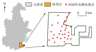
图 1 研究区范围及其水准点空间分布
Figure 1. Scope of the study area and its spatial distribution of benchmark points
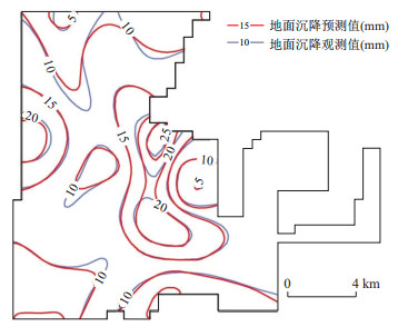
图 2 天津滨海地区地面沉降量等值线图
Figure 2. Contour map of ground subsidence in Tianjin coastal area
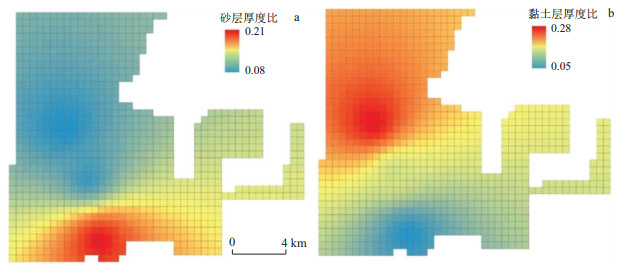
图 3 滨海地区砂层(a)和黏土层(b)厚度比值分布图
砂层厚度比是指砂层厚度/沉积物总厚度;黏土层厚度比是指黏性土厚度/沉积物总厚度
Figure 3. Distribution map of thickness ratio of sand(a) and clay(b) in coastal areas
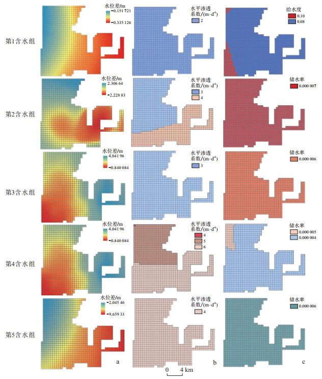
图 4 天津市滨海地区含水组水位差(a)、水平渗透系数(b)以及给水度与储水率(c)分布图
水位差是指含水组研究时间段内水位差异,m;水平渗透系数是指含水层水平方向渗透能力,m/d;给水度, 储水率是指地下水位下降一个单位时,单位面积岩石柱体在重力作用下所释放出的水的体积
Figure 4. Distribution map of water level changes(a), horizontal hydraulic conductivity(b) and specific yield or specific storage(c) of aquifers in Tianjin coastal area
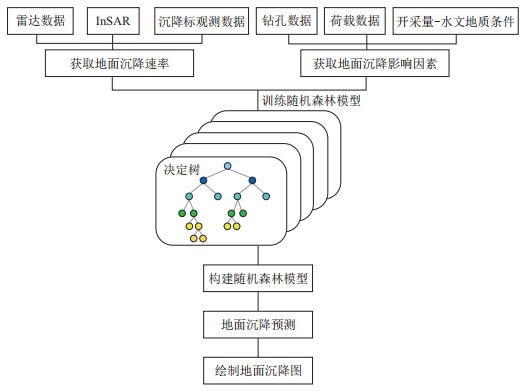
图 5 基于随机森林的地面沉降预测模型示意图
Figure 5. Schematic diagram of ground subsidence prediction model based on random forest
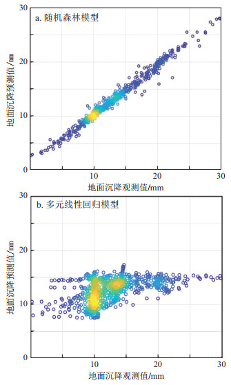
图 6 天津市滨海地区地面沉降随机森林(a)、多元线性回归(b)预测值与观测值对比验证
Figure 6. Comparison of predicted and observed values of ground subsidence using random forest(a) and multilinear regression(b) in Tianjin coastal area
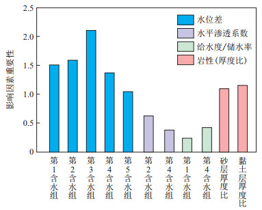
图 7 天津滨海地区地面沉降量影响因素重要性图
Figure 7. Importance of factors influencing ground subsidence in Tianjin coastal area
表 1 天津市滨海地区含水组Pearson参数相关性分析
Table 1. Pearson correlation coefficient analysis of aquifer lithology in Tianjin coastal area
含水组水位差 含水组水平渗透系数 含水组给水度或储水率 岩性(厚度比) 沉降量 1 2 3 4 5 1 2 3 4 5 1 2 3 4 5 砂层 黏性 含水组水位差 1 1.00 0.50 -0.72 0.39 0.97 -0.67 0.53 0.29 0.00 0.00 0.42 0.00 -0.49 -0.55 -0.04 2 0.50 1.00 -0.32 0.07 0.62 -0.53 0.64 0.06 0.00 0.00 0.28 0.00 -0.33 -0.49 -0.21 3 -0.72 -0.32 1.00 -0.75 -0.63 0.40 -0.20 -0.31 0.00 0.00 -0.05 0.00 0.06 0.07 0.05 4 0.39 0.07 -0.75 1.00 0.31 0.00 -0.15 0.18 0.00 0.00 -0.09 0.00 0.36 0.26 -0.21 5 0.97 0.62 -0.63 0.31 1.00 -0.72 0.66 0.16 0.00 0.00 0.48 0.00 -0.55 -0.64 -0.05 含水组水平渗透系数 1 2 -0.67 -0.53 0.40 0.00 -0.72 1.00 -0.74 0.07 0.00 0.00 -0.22 0.00 0.81 0.59 -0.09 3 4 0.53 0.64 -0.20 -0.15 0.66 -0.74 1.00 -0.20 0.00 0.00 0.30 0.00 -0.67 -0.82 0.06 5 含水组给水度或储水率 1 0.29 0.06 -0.31 0.18 0.16 0.07 -0.20 1.00 0.00 0.00 0.02 0.00 0.11 0.10 -0.15 2 0.00 0.00 0.00 0.00 0.00 0.00 0.00 0.00 1.00 -1.00 0.00 1.00 0.00 0.00 0.00 3 0.00 0.00 0.00 0.00 0.00 0.00 0.00 0.00 -1.00 1.00 0.00 -1.00 0.00 0.00 0.00 4 0.42 0.28 -0.05 -0.09 0.48 -0.22 0.30 0.02 0.00 0.00 1.00 0.00 -0.20 -0.31 0.01 5 0.00 0.00 0.00 0.00 0.00 0.00 0.00 0.00 1.00 -1.00 0.00 1.00 0.00 0.00 0.00 岩性(厚度比) 砂岩 -0.49 -0.33 0.06 0.36 -0.55 0.81 -0.67 0.11 0.00 0.00 -0.20 0.00 1.00 0.66 -0.24 黏土层 -0.55 -0.49 0.07 0.26 -0.64 0.59 -0.82 0.10 0.00 0.00 -0.31 0.00 0.66 1.00 -0.05 沉降量 -0.04 -0.21 0.05 -0.21 -0.05 -0.09 0.06 -0.15 0.00 0.00 0.01 0.00 -0.24 -0.05 1.00 注:岩性(厚度比例)是指砂层厚度或黏性土厚度/沉积物总厚度;“—“是指参数没有相关性,不做讨论  下载: 导出CSV
-
[1] HERRERA-GARCÍA G, EZQUERRO P, TOMÁS R, et al. Mapping the global threat of land subsidence[J]. Science, 2021, 371: 34-36. doi: 10.1126/science.abb8549 [2] 李文鹏, 王龙凤, 郭海朋, 等. 中国地面沉降防治成效与对策建议[J]. 中国水利, 2021(7): 32-35.LI W P, WANG L F, GUO H P, et al. Effectiveness and countermeasures of land subsidence control in China[J]. China Water Resources, 2021(7): 32-35. (in Chinese with English abstract) [3] 秦欢欢. 北京平原地面沉降数值模拟情景分析[J]. 地质科技情报, 2019, 38(1): 221-227.QIN H H. Numerical simulation and scenario analysis of land subsidence in Beijing Plain[J]. Geological Science and Technology Information, 2019, 38(1): 221-227. (in Chinese with English abstract) [4] 胡喜梅, 马传明, 邓波, 等. 江苏省沿海地区地面沉降风险评价[J]. 地质科技情报, 2017, 36(2): 222-228.HU X M, MA C M, DENG B, et al. Risk evaluation of land subsidence in coastal areas of Jiangsu Province[J]. Geological Science and Technology Information, 2017, 36(2): 222-228. (in Chinese with English abstract) [5] 薛禹群, 张云, 叶淑君, 等. 我国地面沉降若干问题研究[J]. 高校地质学报, 2006, 12(2): 153-160.XUE Y Q, ZHANG Y, YE S J, et al. Research on the problems of land subsidence in China[J]. Geological Journal of China Universities, 2006, 12(2): 153-160. (in Chinese with English abstract) [6] 罗跃, 叶淑君, 吴吉春. 三维区域地面沉降数值模拟[J]. 岩土力学, 2018, 39(3): 1063-1070.LUO Y, YE S J, WU J C. Numerical model for simulating 3D regional land subsidence[J]. Rock and Soil Mechanics, 2018, 39(3): 1063-1070. (in Chinese with English abstract) [7] 王礼春. 天津市深层地下水资源及其地面沉降数值模拟研究[D]. 北京: 中国地质大学(北京), 2010.WANG L C. The study on deep groundwater resources and subsidence caused by withdrawal with method of numerical simulation in Tianjin district[D]. Beijing: China University of Geosciences(Beijing), 2010. (in Chinese with English abstract) [8] SHI X Q, WU J C, YE S J, et al. Regional land subsidence simulation in Su-Xi-Chang area and Shanghai City, China[J]. Engineering Geology, 2008, 100(1/2): 27-42. [9] MOHAMMADY M, POURGHASEMI H R, AMIRI M. Land subsidence susceptibility assessment using random forest machine learning algorithm[J]. Environmental Earth Sciences, 2019, 78(16): 503. doi: 10.1007/s12665-019-8518-3 [10] 刘青豪, 张永红, 邓敏, 等. 大范围地表沉降时序深度学习预测法[J]. 测绘学报, 2021, 50(3): 396-404.LIU Q H, ZHANG Y H, DENG M, et al. Time series prediction method of large-scale surface subsidence based on deep learning[J]. Acta Geodaetica et Cartographica Sinica, 2021, 50(3): 396-404. (in Chinese with English abstract) [11] YU H R, GONG H L, CHEN B B, et al. Analysis of the influence of groundwater on land subsidence in Beijing based on the geographical weighted regression(GWR) model[J]. Science of the Total Environment, 2020, 738: 139405. doi: 10.1016/j.scitotenv.2020.139405 [12] 杨霄. 菏泽市地面沉降因子识别体系与预测评估模型研究[D]. 济南: 山东大学, 2021.YANG X. Research on the identification system and prediction evaluation model of land subsidence factors in Heze City[D]. Jinan: Shandong University, 2021. (in Chinese with English abstract) [13] BIAU G, SCORNET E. A random forest guided tour[J]. TEST, 2016, 25(2): 197-227. doi: 10.1007/s11749-016-0481-7 [14] 司新毅, 谢新民, 李盛. 基于PS-InSAR和随机森林的天津区域地表形变监测[J]. 大地测量与地球动力学, 2023, 43(7): 692-695.SI X Y, XIE X M, LI S. Surface deformation monitoring of Tianjin area based on PS-InSAR and random forest[J]. Journal of Geodesy and Geodynamics, 2023, 43(7): 692-695. (in Chinese with English abstract) [15] 焦珣, 吴建中, 王寒梅, 等. 软土地区地铁道床沉降特征及其诱发因素分析[J]. 世界地质, 2016, 35(1): 276-282.JIAO X, WU J Z, WANG H M, et al. Characteristics of track-bed settlement and its inducing factors for subway in soft soil districts[J]. Global Geology, 2016, 35(1): 276-282. (in Chinese with English abstract) [16] 张倩, 马悦, 周洪月, 等. 基于InSAR技术的天津局部地表沉降特征分析[J]. 测绘通报, 2024(2): 74-79.ZHANG Q, MA Y, ZHOU H Y, et al. Analysis of local surface subsidence characteristics in Tianjin based on InSAR technology[J]. Bulletin of Surveying and Mapping, 2024(2): 74-79. (in Chinese with English abstract) [17] 李佳琦, 徐佳, 刘杰, 等. 天津地面沉降严重区分布特征及变化规律[J]. 中国地质灾害与防治学报, 2023, 34(2): 53-60.LI J Q, XU J, LIU J, et al. Distribution characteristics and evolution trend of severe land subsidence areas in Tianjin City[J]. The Chinese Journal of Geological Hazard and Control, 2023, 34(2): 53-60. (in Chinese with English abstract) [18] 张庆云, 李雪川, 王宁. 基于SBAS技术的天津市地面形变特征分析[J]. 科学技术与工程, 2022, 22(30): 13202-13210.ZHANG Q Y, LI X C, WANG N. Analysis of ground deformation characteristics in Tianjin based on SBAS technology[J]. Science Technology and Engineering, 2022, 22(30): 13202-13210. (in Chinese with English abstract) [19] 吕潇文. 天津临港工业区地面沉降特征研究[D]. 北京: 中国地质大学(北京), 2014. LÜ X W.Study on the characteristics of land subsidence disaster in Tianjin harbor industrial park[D]. Beijing: China University of Geosciences(Beijing), 2014. (in Chinese with English abstract) [20] 于海若, 宫辉力, 陈蓓蓓, 等. 天津市南部平原地面沉降区新兴风险评估[J]. 自然资源遥感, 2023, 35(2): 182-192.YU H R, GONG H L, CHEN B B, et al. Emerging risk assessment of areas subject to land subsidence in the southern plain of Tianjin, China[J]. Remote Sensing for Natural Resources, 2023, 35(2): 182-192. (in Chinese with English abstract) [21] SHI L Y, GONG H L, CHEN B B, et al. Land subsidence prediction induced by multiple factors using machine learning method[J]. Remote Sensing, 2020, 12(24): 4044. [22] PEDREGOSA F, VAROQUAUX G, GRAMFORT A, et al. Scikit-learn: Machine learning in Python[J]. The Journal of Machine Learning Research, 2011, 12: 2825-2830. [23] SEKKERAVANI M A, BAZRAFSHAN O, POURGHASEMI H R, et al. Spatial modeling of land subsidence using machine learning models and statistical methods[J]. Environmental Science and Pollution Research International, 2022, 29(19): 28866-28883. [24] 段永侯, 王家兵, 王亚斌, 等. 天津市地下水资源与可持续利用[J]. 水文地质工程地质, 2004, 31(3): 29-39.DUAN Y H, WANG J B, WANG Y B, et al. Groundwater resources and its sustainable development in Tianjin[J]. Hydrogeology and Engineering Geology, 2004, 31(3): 29-39. (in Chinese with English abstract) -

 下载:
下载:

 点击查看大图
计量
- 文章访问数: 341
- PDF下载量: 44
- 被引次数: 0

