


Multi-factor risk assessment of landslide disasters under concentrated rainfall in Xianrendong national nature reserve in southern Liaoning Province
-
摘要:
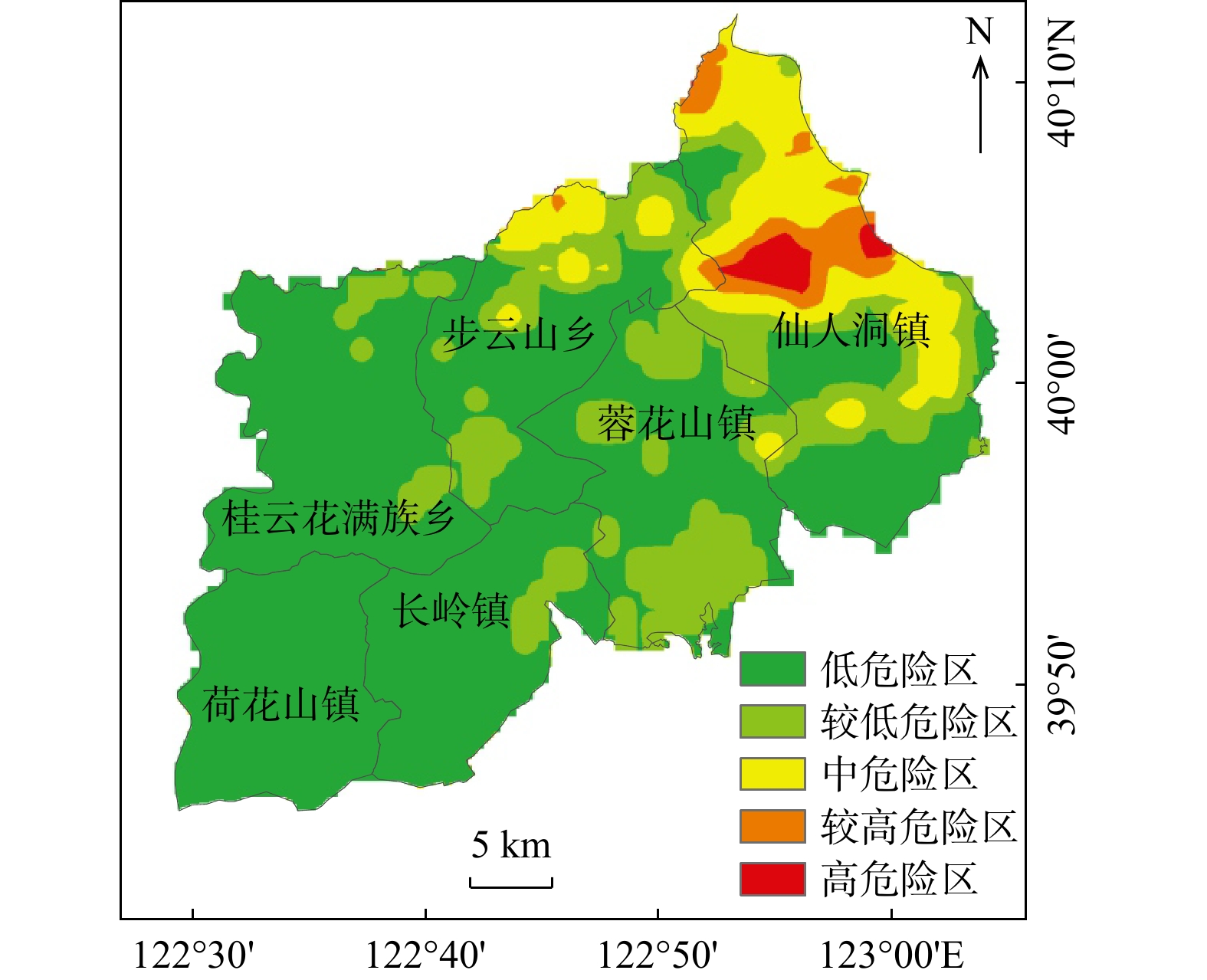
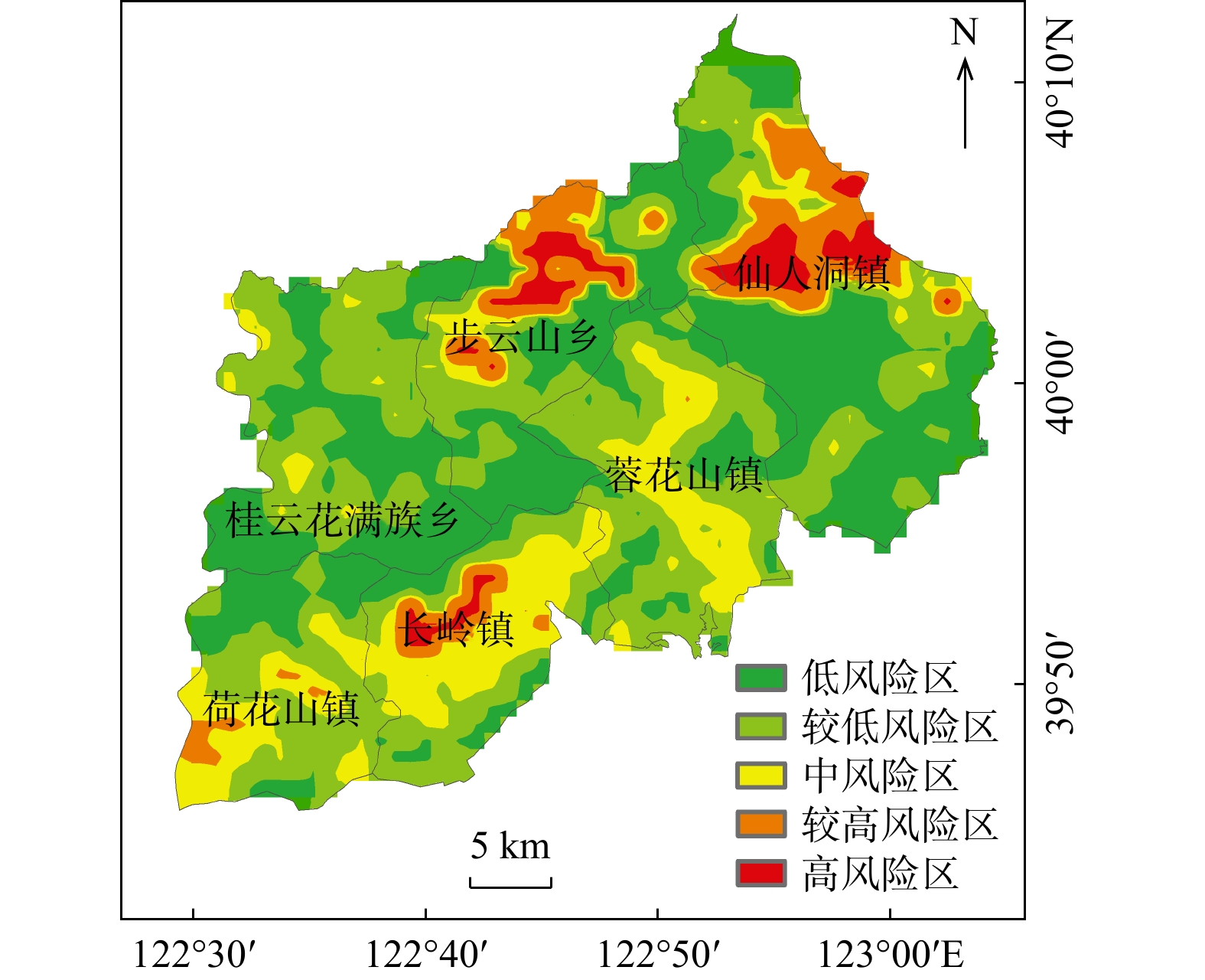
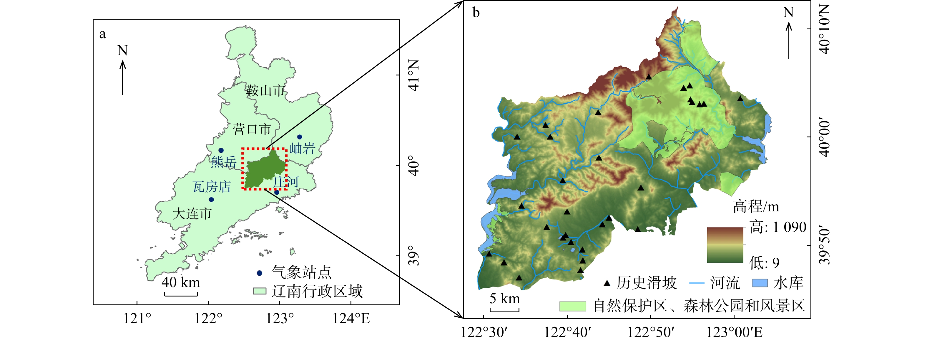
位于辽宁省南部的仙人洞国家级自然保护区及毗邻区域,近年来在集中降雨期间多次发生滑坡等地质灾害;然而,针对集中降雨影响下该区域滑坡灾害易发性与风险评价还很少探究,因此亟待开展深入研究,这对有效减轻保护区地质灾害危害、提升地质灾害应急和风险防控能力具有重要意义。首先利用SMOTE-Tomek综合采样法、耦合XGBoost模型,对地形地貌、地质岩性、水文气象和人类工程活动因子等12个指标进行深入分析,以获取滑坡灾害易发性评价结果;其次,着重考虑短时间集中降雨和连续性降雨影响,利用研究区周围4个气象站的日降雨数据,计算2018−2023年平均暴雨强度和3 d累计降雨量,作为危险性评价指标,实现对滑坡灾害危险性的量化评估。在此基础上,考虑承灾体的易损性特点和区域防灾减灾能力,构建适用于研究区的多因子滑坡灾害风险评价模型,进而得到滑坡灾害风险评价分区图。结果表明:较高及以上等级风险区约占研究区总面积的10%,主要分布在仙人洞镇东北部、步云山乡北部、长岭镇北部和荷花山镇西南部。未来应重点关注滑坡地质灾害风险较高的仙人洞镇和步云山乡,加强监测和预警工作,为整个研究区的地质灾害防控提供决策支持。
Abstract:Objective Xianrendong National Nature Reserve in southern Liaoning Province and its adjacent areas have experienced numerous geological disasters, such as landslides, during periods of concentrated rainfall in recent years. However, the vulnerability and risk assessment of landslide disasters in this region under the influence of concentrated rainfall have been rarely explored. Therefore, it is urgent to conduct in-depth research, which is of great significance for effectively reducing the harm of geological disasters in the reserve and enhancing the capacity for emergency response and risk prevention and control.
Method Firstly, using the SMOTE-Tomek comprehensive sampling method coupled with an XGBoost model, 12 indices including topography, geology and lithology, hydrometeorology, and human engineering activities are deeply analyzed to obtain the evaluation results of landslide susceptibility. Secondly, focusing on the impact of short-term concentrated rainfall and continuous rainfall, daily rainfall data from four weather stations surrounding the study area are used to calculate annual average rainstorm intensity from 2018 to 2023 and three-day cumulative rainfall as risk assessment indicators, enabling the quantitative assessment of landslide hazards. On this basis, considering the vulnerability characteristics of the disaster-bearing body and regional disaster prevention and mitigation capabilities, a multi-factor landslide disaster risk assessment model suitable for the study area is constructed, resulting in a landslide disaster risk zoning map.
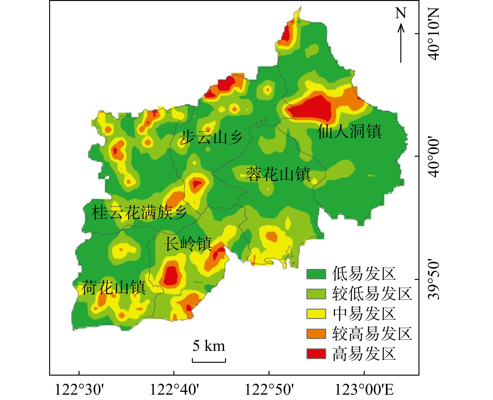
Result The results show that high-risk and above areas account for approximately 10% of the total study area, primarily distributed in the northeast of Xianrendong Town, the north of Buyunshan Town, the north of Changling Town, and the southwest of Hehuashan Town.
Conclusion In the future, efforts should focus on high-risk areas such as Xianrendong Town, strengthening monitoring and early warning systems to provide decision support for the prevention and control of geological disasters across the entire study area.
-
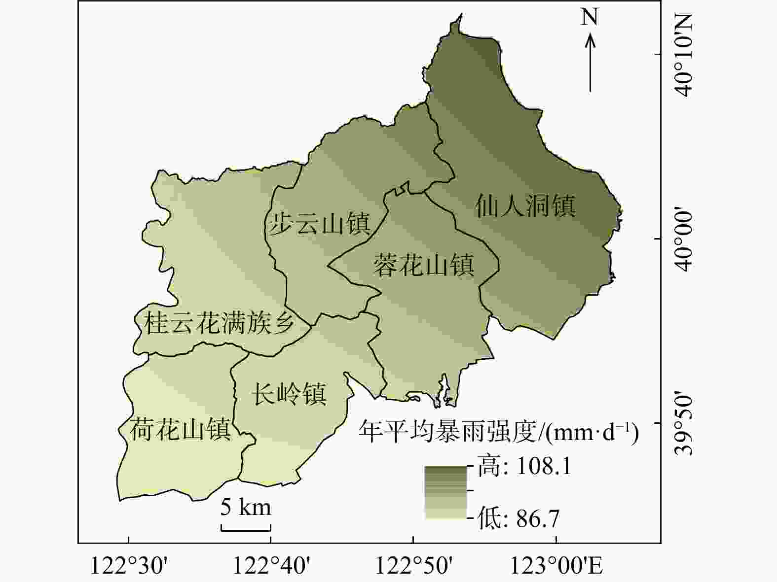
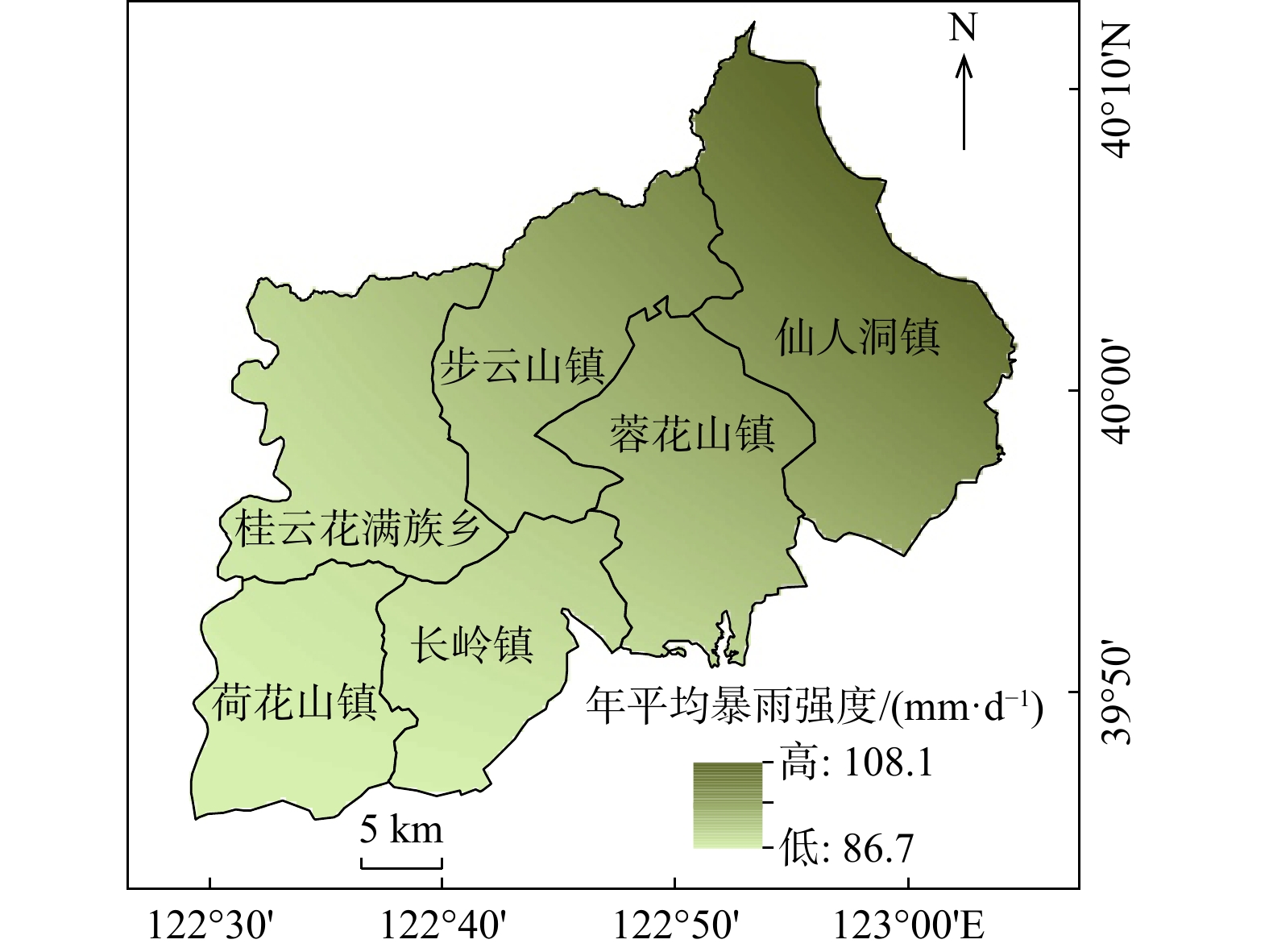
图 3 研究区2018−2023年平均降雨强度空间分布图
Figure 3. Spatial distribution map of annual average rainfall intensity from 2018 to 2023 in the study area
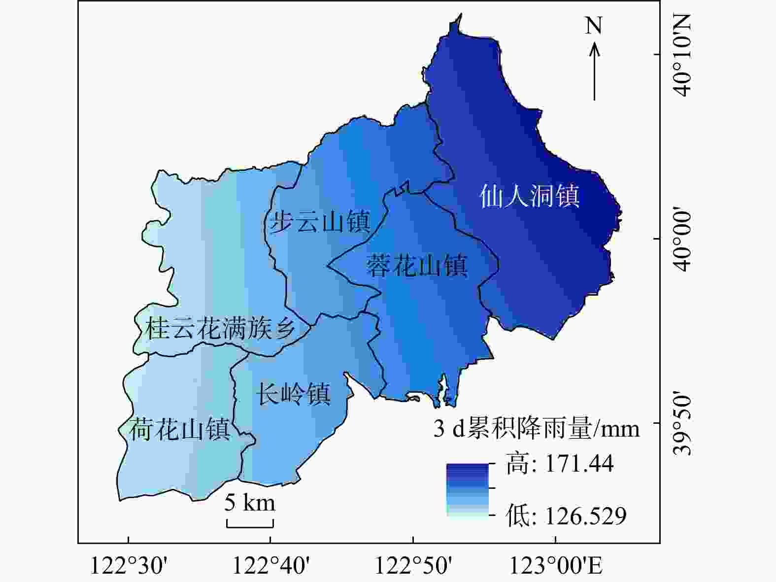
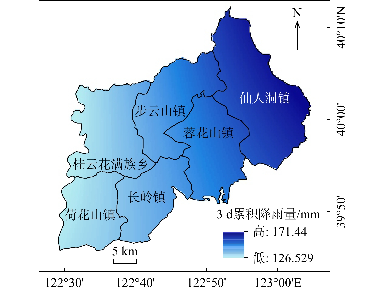
图 4 研究区3 d累计降雨量空间分布图
Figure 4. Spatial distribution map of three-day cumulative rainfall in the study area
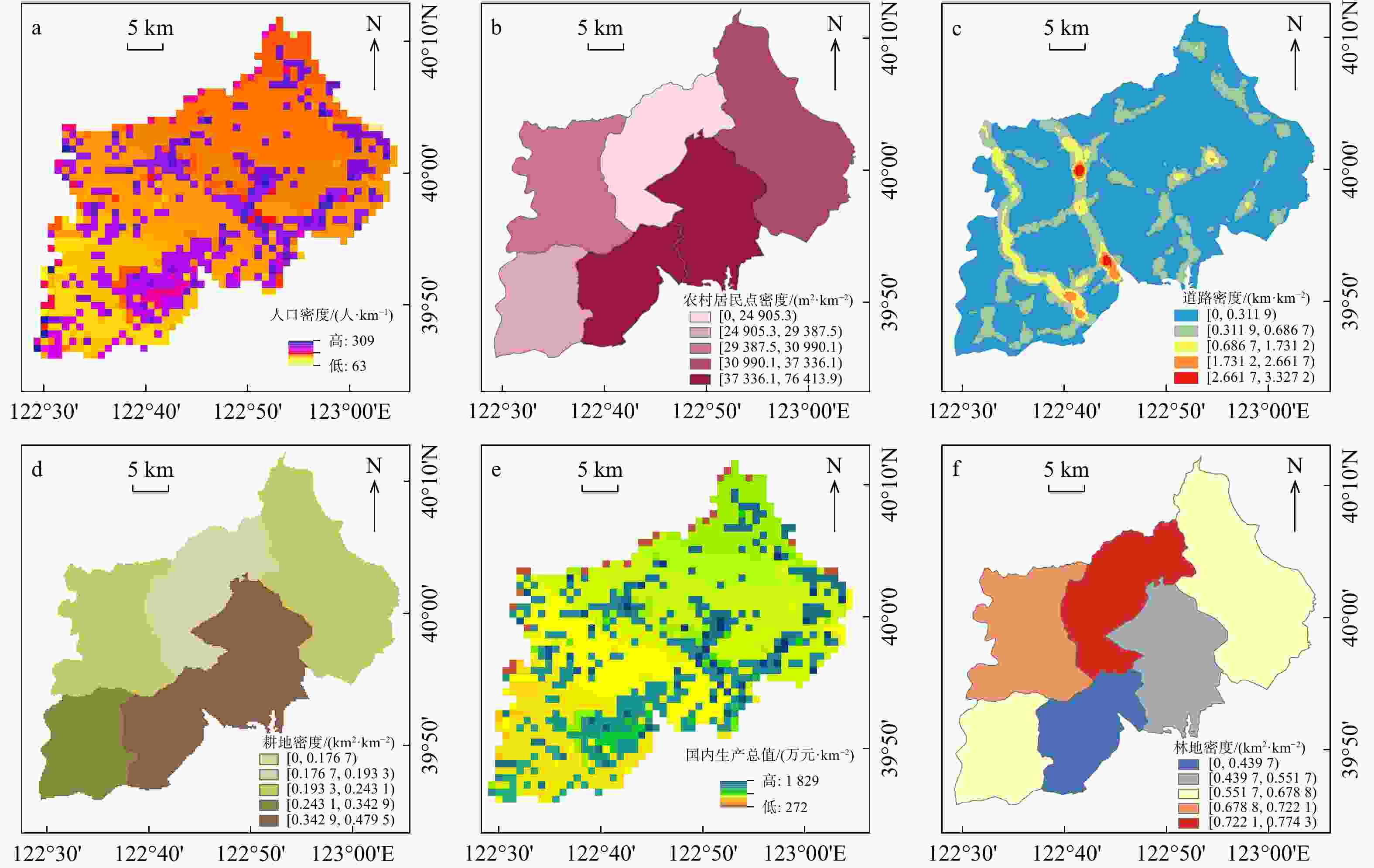
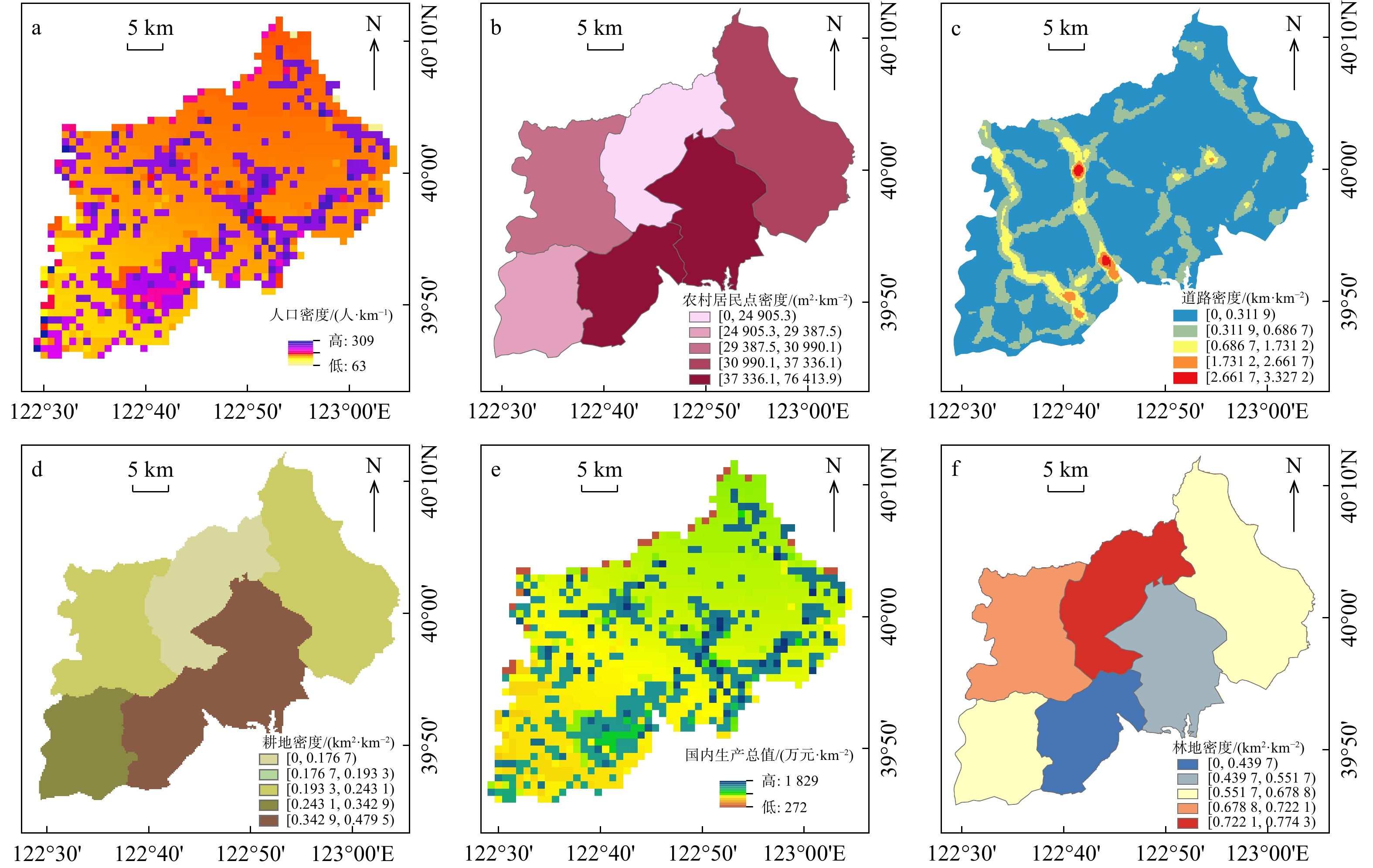
图 5 研究区滑坡灾害承灾体易损性评价因子分布图
Figure 5. Distribution map of vulnerability evaluation factors of landslide disaster-bearing bodies in the study area
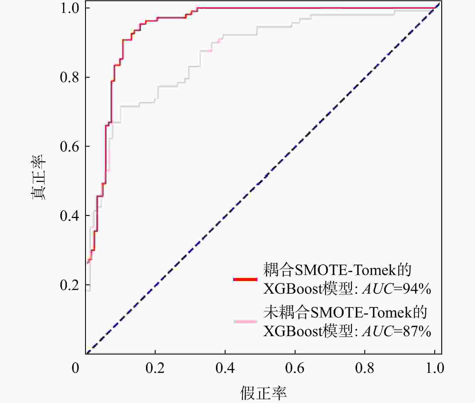
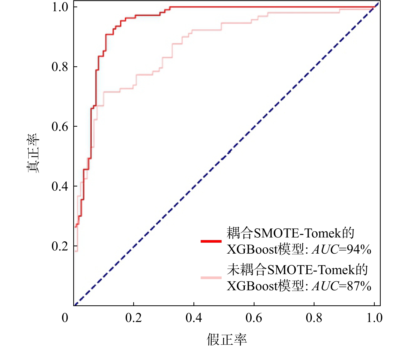
图 7 滑坡灾害易发性评价ROC曲线
Figure 7. ROC curve of landslide disaster susceptibility evaluation

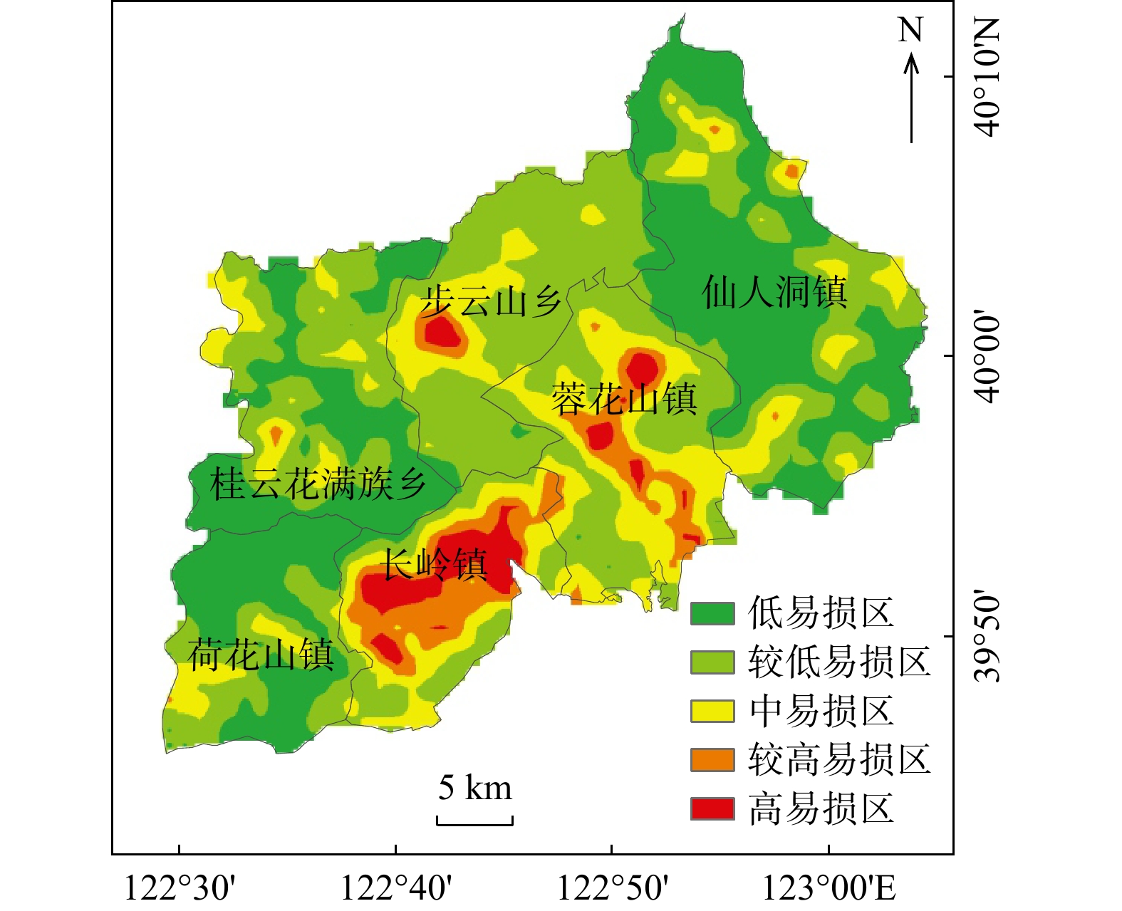
图 9 研究区滑坡灾害承灾体易损性分区图
Figure 9. Vulnerability zoning map of landslide disaster-bearing bodies in the study area
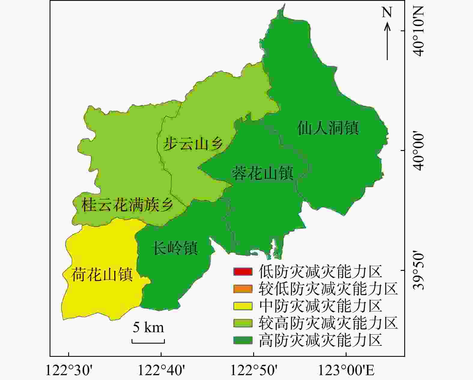
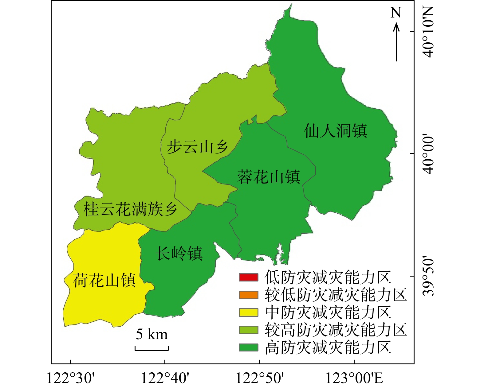
图 10 研究区防灾减灾能力分区图
Figure 10. Zoning map of disaster prevention and mitigation capacity of the study area
表 1 研究区滑坡灾害易发性评价因子及其分类区间和分类标准
Table 1. Evaluation factors, classification intervals and standards of landslide disaster susceptibility in the study area
一级指标 二级指标 分类区间 分级标准 地形地貌 高程/m <134,[134,238),[238,370),[370,549],>549 自然断点法 坡向 平地、北、东北、东、东南、南、西南、西、西北 文献[21] 坡度/(°) <5.97,[5.97,11.73),[11.73,18.14),[18.14,25.4],>25.4 自然断点法 地形起伏度/m <9,[9,19),[19,29),[29,41],>41 自然断点法 地形湿度指数 <5.86,[5.86,7.74),[7.74,10.67),[10.67,14.75],>14.75 自然断点法 地质岩性 岩性 极硬、硬、较硬、较软、软 工程岩体分级标准 距断层距离/m <500,[500, 1000 ),[1000 ,1500 ),[1500 ,2000 ],>2000等间距划分 气象水文 汛期年降雨量/(mm·a−1) <502.2,[502.2,520.0),[520.0,538.2),[538.2,556.0],>556.0 自然断点法 距河流距离/m <200,[200,400),[400,600),[600,800],>800 等间距划分 人类工程
活动土地利用 水域、未利用地、耕地、建设用地、林地、草地 国家土地利用分类标准 距道路距离/m <200,[200,500),[500,800),[800, 1200 ),[1200 ,2500 ],>2500 文献[22-23] 归一化植被指数 <0.68,[0.68,0.74),[0.74,0.80),[0.80,0.85],>0.85 自然断点法 注:数据来源①数字高程模型数据:中国地理空间数据云网(http://www.gscloud.cn/),分辨率为30 m×30 m;②土地利用数据:地理监测云平台(https://www.dsac.cn);③岩性和断层数据:提取自大连市1∶25万地质图(全国地质资料馆网站thhp://www.ngac.cn);④水文气象数据:中国气象数据网(http://data.cma.cn);⑤水系和道路数据:OpenStreetMap网站(https://www.openstreetmap.org);⑥归一化植被指数数据:资源环境科学与数据中心(https://www.resdc.cn),分辨率为1 km×1 km  下载: 导出CSV
表 2 研究区滑坡灾害承灾体易损性评价因子和分级标准
Table 2. Vulnerability evaluation factors and grading standards of landslide disaster-bearing bodies in the study area
一级指标 二级指标 指标权重 低易损性 较低易损性 中易损性 较高易损性 高易损性 人口易损性 人口密度/(人·km−2) 0.3664 <156 [156,179) [179,212) [212,250] >250 物质易损性 农村居民点密度/(104m2·km−2) 0.1496 <2.45 [2.45,2.94) [2.94,3.10) [3.10,3.73] >3.73 道路密度/(km·km−2) 0.0849 <0.31 [0.31,0.69) [0.69,1.73) [1.73,2.66] >2.66 经济易损性 耕地密度/(km2·km−2) 0.1245 <0.18 [0.18,0.19) [0.19,0.24) [0.24,0.34] >0.34 国内生产总值/(万元·km−2) 0.0522 <660 [660, 1064 )[ 1064 ,1292 )[ 1292 ,1611 ]> 1611 林地密度/(km2·km−2) 0.2224 <0.44 [0.44,0.55) [0.55,0.68) [0.68,0.72] >0.72 注:①人口密度和国内生产总值数据来源于资源环境科学数据注册与出版系统(https://www.resdc.cn);②农村居民点、耕地、林地数据来源于资源环境科学与数据中心(https://www.resdc.cn)
下载: 导出CSV
表 3 研究区防灾减灾能力评价指标及对应权重
Table 3. Indicators and corresponding weights of disaster prevention and mitigation capacity in the study area
一级指标 一级指标
权重${\omega _{\mathrm{f}}}$二级指标 二级指标
权重${\omega _{\mathrm{g}}}$防灾能力 0.3091 地质勘探与测绘公司数量/个 0.6667 地方一般公共预算支出/万元 0.3333 应灾能力 0.5813 义务教育在校学生数/人 0.2298 居民青壮年人数占长居人数比例 0.6479 医护人员数/人 0.1223 灾后重建
能力0.1096 住户储蓄存款余额/万元 0.7500 医疗、社区、卫生院床位/张 0.2500 注:防灾减灾能力数据来源于《2023中国县域统计年鉴(乡镇版)》、《2023大连市统计年鉴》
下载: 导出CSV
-
[1] 黄发明,汪洋,董志良,等. 基于灰色关联度模型的区域滑坡敏感性评价[J]. 地球科学,2019,44(2):664-676.HUANG F M,WANG Y,DONG Z L,et al. Regional landslide susceptibility mapping based on grey relational degree model[J]. Earth Science,2019,44(2):664-676. (in Chinese with English abstract [2] 裴振伟,年廷凯,吴昊,等. 滑坡地质灾害应急处置技术研究进展[J]. 防灾减灾工程学报,2021,41(6):1382-1394.PEI Z W,NIAN T K,WU H,et al. Research progress on emergency treatment techniques for landslide geological hazards[J]. Journal of Disaster Prevention and Mitigation Engineering,2021,41(6):1382-1394. (in Chinese with English abstract [3] 闫成林,郑德凤,年廷凯,等. 基于ANP的模糊贝叶斯网络模型及其在海岸带地质灾害风险评价中的应用[J]. 工程地质学报,2021,29(6):1862-1868.YAN C L,ZHENG D F,NIAN T K,et al. Fuzzy Bayesian network model based on anp and its application to coastal zone geohazard risk assessment[J]. Journal of Engineering Geology,2021,29(6):1862-1868. (in Chinese with English abstract [4] LI Y Y,ZHENG D F,YAN C L,et al. Spatial distributions and multi-factor driving mechanism of landslide in southern Liaodong Peninsula[J]. Frontiers in Ecology and Evolution,2024,11:1339265. doi: 10.3389/fevo.2023.1339265 [5] 国家地震局震害防御司,自然灾害学报编辑部. 国际减轻自然灾害十年计划的实施[M]. 北京:地震出版社,1992.Earthquake Disaster Prevention Department of State Seismological Bureau,Editorial Department of Journal of Natural Disasters. Implementation of the international ten-year plan for natural disaster reduction[M]. Beijing:Seismological Press,1992. (in Chinese) [6] 黄发明,胡松雁,闫学涯,等. 基于机器学习的滑坡易发性预测建模及其主控因子识别[J]. 地质科技通报,2022,41(2):79-90.HUANG F M,HU S Y,YAN X Y,et al. Landslide susceptibility prediction and identification of its main environmental factors based on machine learning models[J]. Bulletin of Geological Science and Technology,2022,41(2):79-90. (in Chinese with English abstract [7] ZHANG S H,TAN S C,ZHOU J X,et al. Geological disaster susceptibility evaluation of a random-forest-weighted deterministic coefficient model[J]. Sustainability,2023,15(17):12691. doi: 10.3390/su151712691 [8] 刘帅,朱杰勇,杨得虎,等. 不同降雨工况条件下的崩滑地质灾害危险性评价[J]. 地质科技通报,2024,43(2):253-267.LIU S,ZHU J Y,YANG D H,et al. Geological hazard risk assessment of collapse and landslide under different rainfall conditions[J]. Bulletin of Geological Science and Technology,2024,43(2):253-267. (in Chinese with English abstract [9] 张迎宾,徐佩依,林剑锋,等. 基于BP神经网络的九寨沟地区地震滑坡危险性预测研究[J]. 工程地质学报,2024,32(1):133-145.ZHANG Y B,XU P Y,LIN J F,et al. Earthquake-triggered landslide susceptibility prediction in Jiuzhaigou based on BP neural network[J]. Journal of Engineering Geology,2024,32(1):133-145. (in Chinese with English abstract [10] DIKSHIT A,SARKAR R,PRADHAN B,et al. Spatial landslide risk assessment at phuentsholing,Bhutan[J]. Geosciences,2020,10(4):131. doi: 10.3390/geosciences10040131 [11] NOVELLINO A,CESARANO M,CAPPELLETTI P,et al. Slow-moving landslide risk assessment combining machine learning and InSAR techniques[J]. CATENA,2021,203:105317. doi: 10.1016/j.catena.2021.105317 [12] RAM P,GUPTA V. Landslide hazard,vulnerability,and risk assessment (HVRA),Mussoorie Township,lesser Himalaya,India[J]. Environment,Development and Sustainability,2022,24(1):473-501. [13] TANIMU J J,HAMADA M,HASSAN M,et al. A machine learning method for classification of cervical cancer[J]. Electronics,2022,11(3):463. doi: 10.3390/electronics11030463 [14] 郑德凤,高敏,闫成林,等. 基于卷积神经网络的滑坡易发性评价:以辽南仙人洞国家级自然保护区为例[J]. 地球科学,2024,49(5):1654-1664.ZHENG D F,GAO M,YAN C L,et al. Susceptibility assessment of landslides based on convolutional neural network model:A case study from Xianrendong National Nature Reserve in southern Liaoning Province[J]. Earth Science,2024,49(5):1654-1664. (in Chinese with English abstract [15] CHANDRA W,SUPRIHATIN B,RESTI Y. Median-KNN regressor-SMOTE-tomek links for handling missing and imbalanced data in air quality prediction[J]. Symmetry,2023,15(4):887. doi: 10.3390/sym15040887 [16] DENG S,PAN H Y,LI C W,et al. A real-time lithological identification method based on SMOTE-tomek and ICSA optimization[J]. Acta Geologica Sinica (English Edition),2024,98(2):518-530. doi: 10.1111/1755-6724.15144 [17] TARIQ M A,SARGANO A B,IFTIKHAR M A,et al. Comparing different oversampling methods in predicting multi-class educational datasets using machine learning techniques[J]. Cybernetics and Information Technologies,2023,23(4):199-212. doi: 10.2478/cait-2023-0044 [18] SHI N,LI Y L,WEN L F,et al. Rapid prediction of landslide dam stability considering the missing data using XGBoost algorithm[J]. Landslides,2022,19(12):2951-2963. doi: 10.1007/s10346-022-01947-y [19] 吴润泽,胡旭东,梅红波,等. 基于随机森林的滑坡空间易发性评价:以三峡库区湖北段为例[J]. 地球科学,2021,46(1):321-330.WU R Z,HU X D,MEI H B,et al. Spatial susceptibility assessment of landslides based on random forest:A case study from Hubei section in the Three Gorges Reservoir area[J]. Earth Science,2021,46(1):321-330. (in Chinese with English abstract [20] 年廷凯,王国栋,郑德凤,等. 南海北部陆坡区典型峡谷陡坡群地震稳定性[J]. 吉林大学学报(地球科学版),2023,53(6):1785-1798.NIAN T K,WANG G D,ZHENG D F,et al. Seismic stability of steep slope groups in typical canyons of northern South China Sea[J]. Journal of Jilin University (Earth Science Edition),2023,53(6):1785-1798. (in Chinese with English abstract [21] 李星,杨赛,李远耀,等. 面向区域滑坡易发性精细化评价的改进斜坡单元法[J]. 地质科技通报,2023,42(3):81-92.LI X,YANG S,LI Y Y,et al. Improved slope unit method for fine evaluation of regional landslide susceptibility[J]. Bulletin of Geological Science and Technology,2023,42(3):81-92. (in Chinese with English abstract [22] 吴宏阳,周超,梁鑫,等. 基于XGBoost模型的三峡库区燕山乡滑坡易发性评价与区划[J]. 中国地质灾害与防治学报,2023,34(5):141-152.WU H Y,ZHOU C,LIANG X,et al. Assessment of landslide susceptibility mapping based on XGBoost model:A case study of Yanshan Township[J]. The Chinese Journal of Geological Hazard and Control,2023,34(5):141-152. (in Chinese with English abstract [23] 胡杨,张紫昭,林世河. 基于证据权与逻辑回归耦合的新疆伊犁河谷地区滑坡易发性评价[J]. 工程地质学报,2023,31(4):1350-1363.HU Y,ZHANG Z Z,LIN S H. Evaluation of landslide susceptibility in Ili valley,Xinjiang based on the coupling of WOE model and logistic re-gression[J]. Journal of Engineering Geology,2023,31(4):1350-1363. (in Chinese with English abstract ). [24] LI W,YIN Y B,QUAN X W,et al. Gene expression value prediction based on XGBoost algorithm[J]. Frontiers in Genetics,2019,10:1077. doi: 10.3389/fgene.2019.01077 [25] QIU Y G,ZHOU J,KHANDELWAL M,et al. Performance evaluation of hybrid WOA-XGBoost,GWO-XGBoost and BO-XGBoost models to predict blast-induced ground vibration[J]. Engineering with Computers,2022,38(5):4145-4162. [26] ZHANG P,JIA Y Q,SHANG Y L. Research and application of XGBoost in imbalanced data[J]. International Journal of Distributed Sensor Networks,2022,18(6):155013292211069. [27] 张富灵. 库水及降雨作用下滑移-弯曲型滑坡形成条件与演化机制研究:以木鱼包滑坡为例[D]. 湖北宜昌:三峡大学,2021.ZHANG F L. Study on formation conditions and evolution mechanism of slip-bend landslide under the action of reservoir water and rainfall:Taking Muyubao landslide as an example[D]. Yichang Hubei:China Three Gorges University,2021. (in Chinese with English abstract [28] LIN J H,CHEN W H,QI X H,et al. Risk assessment and its influencing factors analysis of geological hazards in typical mountain environment[J]. Journal of Cleaner Production,2021,309:127077. doi: 10.1016/j.jclepro.2021.127077 [29] LIN J H,LIN M S,CHEN W H,et al. Ecological risks of geological disasters and the patterns of the urban agglomeration in the Fujian delta region[J]. Ecological Indicators,2021,125:107475. doi: 10.1016/j.ecolind.2021.107475 [30] 丁明涛,庙成. 基于GIS的芦山地震灾区滑坡灾害风险评价[J]. 自然灾害学报,2014,23(4):81-90.DING M T,MIAO C. GIS-based risk assessment of landslide hazards in Lushan earthquake-stricken areas[J]. Journal of Natural Disasters,2014,23(4):81-90. (in Chinese with English abstract [31] 刘海洋,王录仓,常跟应. 郑州“7·20” 特大暴雨灾害对中国铁路运网的冲击过程和机制[J]. 地理学报,2024,79(3):617-634. doi: 10.11821/dlxb202403005LIU H Y,WANG L C,CHANG G Y. The impact process and mechanism of the superheavy rainfall event in Zhengzhou on July 20,2021 on the China's railway transport network[J]. Acta Geographica Sinica,2024,79(3):617-634. (in Chinese with English abstract doi: 10.11821/dlxb202403005 [32] HU S Y,YU M,QUE T,et al. Individual willingness to prepare for disasters in a geological hazard risk area:An empirical study based on the protection motivation theory[J]. Natural Hazards,2022,110(3):2087-2111. doi: 10.1007/s11069-021-05026-8 [33] SHAO L F. Geological disaster prevention and control and resource protection in mineral resource exploitation region[J]. International Journal of Low-Carbon Technologies,2019,14(2):142-146. doi: 10.1093/ijlct/ctz003 [34] CHEN L,HUANG Y C,BAI R Z,et al. Regional disaster risk evaluation of China based on the universal risk model[J]. Natural Hazards,2017,89(2):647-660. doi: 10.1007/s11069-017-2984-2 [35] YE J Y,ZHANG R Y,LIN G F,et al. Comprehensive risk assessment of non-typhoon rainstorms over the southeastern coastal region of China[J]. Frontiers in Environmental Science,2022,10:1058054. doi: 10.3389/fenvs.2022.1058054 [36] 荣广智,张继权,李天涛,等. 极端降水诱发地质灾害链风险评估研究:以贵州省水城县为例[J]. 灾害学,2022,37(4):201-210. doi: 10.3969/j.issn.1000-811X.2022.04.031RONG G Z,ZHANG J Q,LI T T,et al. Risk assessment of extreme precipitation-induced geological disaster chain:A case study of Shuicheng County,Guizhou Province[J]. Journal of Catastrophology,2022,37(4):201-210. (in Chinese with English abstract doi: 10.3969/j.issn.1000-811X.2022.04.031 [37] 王婷,吴绍洪,高江波,等. 区域台风−洪涝−地质灾害链减灾能力评估[J]. 灾害学,2022,37(4):193-200. doi: 10.3969/j.issn.1000-811X.2022.04.030WANG T,WU S H,GAO J B,et al. Coping capacity assessment of regional typhoon-flood-geological disaster chain[J]. Journal of Catastrophology,2022,37(4):193-200. (in Chinese with English abstract doi: 10.3969/j.issn.1000-811X.2022.04.030 [38] 石菊松,石玲,吴树仁. 利用GIS技术开展滑坡制图的技术方法与流程[J]. 地质通报,2008,27(11):1810-1821. doi: 10.3969/j.issn.1671-2552.2008.11.008SHI J S,SHI L,WU S R. Techniques and procedures of applications of the GIS technique in landslide map making[J]. Geological Bulletin of China,2008,27(11):1810-1821. (in Chinese with English abstract doi: 10.3969/j.issn.1671-2552.2008.11.008 [39] 郑迎凯,陈建国,王成彬,等. 确定性系数与随机森林模型在云南芒市滑坡易发性评价中的应用[J]. 地质科技通报,2020,39(6):131-144.ZHENG Y K,CHEN J G,WANG C B,et al. Application of certainty factor and random forests model in landslide susceptibility evaluation in Mangshi City,Yunnan Province[J]. Bulletin of Geological Science and Technology,2020,39(6):131-144. (in Chinese with English abstract [40] 王璨,肖浩,肖婷,等. 基于机器学习的长沙市滑坡灾害快速风险评价[J]. 矿冶工程,2023,43(5):26-31. doi: 10.3969/j.issn.0253-6099.2023.05.006WANG C,XIAO H,XIAO T,et al. Efficient risk assessment of landslide disasters in Changsha City based on machine learning[J]. Mining and Metallurgical Engineering,2023,43(5):26-31. (in Chinese with English abstract doi: 10.3969/j.issn.0253-6099.2023.05.006 -

 下载:
下载:

 点击查看大图
计量
- 文章访问数: 90
- PDF下载量: 9
- 被引次数: 0

