


Comparison and analysis of CryoSat DEM and the several Antarctic DEM
-
摘要: 南极洲被巨厚冰雪覆盖,地质构造以南极横断山脉为界,总体分为东南极地盾和西南极活动带。数字高程模型(DEM)是研究南极冰盖变化的基础数据之一。通过多期次数字高程模型相比较获得高程的变化信息,是分析南极冰盖厚度变化和物质平衡的重要手段。然而不同类型DEM之间存的平面误差和垂直误差影响分析结果的精度。首先利用配准消除DEM间的水平误差,然后计算并按坡度提取CryoSat DEM与其他DEM的平均高程差和标准差,最后分析高程差的时空变化特征。通过分析发现,DEM之间存在不同的平面误差。其中TanDEM_X DEM与CryoSat DEM的高程平面偏差最小,而ICESat DEM与CryoSat DEM的高程平面偏差最大。在垂直方向上,0°~1°的坡度范围内,CryoSat DEM与TanDEM_X DEM的平均高程差在3.5~5.5 m之间,标准差小于18.0 m;CryoSat DEM和Bamber 1km DEM的平均高程差在-2.5~+1.0 m之间,标准差小于24.2 m;CryoSat DEM与ICESat DEM的平均高程差在-25.0~-1.0 m之间,标准差小于47.2 m;CryoSat DEM与RAMPv2 DEM的平均高程差在1.3~3.2 m之间,标准差小于45.6 m。通过研究发现南极冰盖内部高程增加,但西南极冰盖和东南极冰盖高程均在降低,且西南极降低明显,同时南极边缘地区高程降低明显。本研究为全球变化研究和南极物质平衡研究提供了重要参考。Abstract: Antarctica is covered by huge snow and ice, and its geological structure is bounded by the Trans-Antarctic Mountains, and is generally divided into the East Antarctic Shield and the West Antarctic Active Zone. Digital elevation model (DEM) is one of the important basic data to study the Antarctic ice sheet change. Obtaining elevation change information through the comparison of multi-period DEM is an important means to analyze the changes in the thickness and material balance of the Antarctic ice sheet. However, the horizontal and vertical errors between different types of DEM affect the accuracy of the analysis results. In this study, the horizontal error first eliminated by registration between DEMs, then elevation difference and standard deviation are calculated between CryoSat DEM and other DEMs, finally the temporal and spatial variation characteristics are evaluated. The results show that in the plane, the horizontal offset between TanDEM_X DEM and CryoSat DEM is the smallest, while that between ICESat DEM and CryoSat DEM is the largest. In the vertical direction, within the gradient range of 0° ~ 1°, the mean elevation difference between CryoSat DEM and TanDEM_X DEM is between 3.5 and 5.5 m, and the standard deviation is less than 18.0 m. The mean elevation difference between CryoSat DEM and Bamber 1km DEM is between -2.5 and +1.0 m, and the standard deviation is less than 24.2 m. The mean elevation difference between CryoSat DEM and ICESat DEM is between -25.0 and -1.0 m, and the standard deviation is less than 47.2 m. The mean elevation difference between CryoSat DEM and RAMPv2 DEM is between 1.3 and 3.2 m, and the standard deviation is less than 45.6 m. It is found that the internal elevation of Antarctic ice sheet increases, but the elevation of southwest ice sheet and southeast ice sheet decreases, and the southwest pole decreases obviously, while the elevation of Antarctic edge area decreases obviously. This study provides an important reference for global change research and Antarctic material balance research.
-
Key words:
- Antarctic /
- geological structure /
- digital elevation model /
- horizontal error /
- elevation difference
-

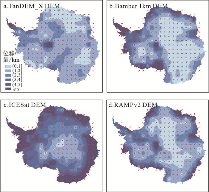
图 2 南极地区各类DEM与CryoSat DEM的水平位移
Figure 2. Horizontal shifts of various Antarctic with CryoSat DEM

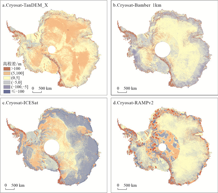
图 3 南极地区5种DEM间高程差分布
Figure 3. Distribution of the elevation differences for the 5 Antarctic DEMs

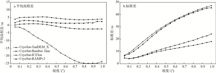
图 4 南极地区5种DEM间高程差按坡度统计
Figure 4. Elevation differences of the 5 Antarctic DEMs as a function of surface slope

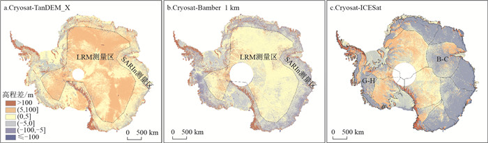
图 5 南极地区5种DEM间高程差空间分布
Figure 5. Spatial distribution of the elevation differences of the 5 Antarctic DEMs

图 6 南极地区DEM间高程差空间分布
Figure 6. Spatial distribution of the elevation differences of the Antarctic DEMs
表 1 南极地区5种DEM对比
Table 1. Comparison of the 5 digital elevation models of Antarctica
RAMPv2 DEM ICESat DEM Bamber 1km DEM TanDEM_X DEM CryoSat DEM 发布时间 1999年 2007年 2009年 2016年 2018年 使用数据 ERS-1测高数据,ADD、USGS
等制图数据,GPS实测数据等ICESat测高数据 ERS-1和ICEsat测高数据 SAR数据 CryoSat-2测高数据 覆盖范围 63°~90°S 63°~86°S 60°~86°S 60°~90°S 60°~88°S 空间分辨率 200,400,1 000 m 500 m 1 km — 1 km 数据采集时间 20世纪40年代-90年代 2003/02-2005/06 1994/03-1995/05,
2003/02-2008/032010/12-2015/01 2010/07-2016/07 网格投影 极方位 极方位 极方位 — 极方位 投影椭球 TOPEX/Poseidon、WGS84 TOPEX/Poseidon WGS84 — WGS84 高程基准 WGS84、OSU91A WGS84、EGM96 WGS84 WGS84 WGS84 数据格式 ARC/INFO、二进制、ASCII 二进制 二进制、ASCII 二进制 二进制  下载: 导出CSV
表 2 南极地区5种DEM高程求差统计
Table 2. Statistics of elevation differences for the 5 Antarctic DEMs
统计参数 CryoSat-TanDEM_X CryoSat-Bamber1km CryoSat-ICESat CryoSat-RAMPv2 均值/m 5.126 0.532 -6.808 2.812 标准差/m 11.167 13.154 24.379 22.424
下载: 导出CSV
表 3 南极地区5种DEM间高程差按坡度统计结果
Table 3. Statistics of the elevation differences for the 5 Antarctic DEMs as a function of the regional surface slope
坡度/(°) CryoSat-TanDEM_X CryoSat-Bamber 1 km CryoSat-ICESat CryoSat-RAMPv2 均值/m 标准差/m 均值/m 标准差/m 均值/m 标准差/m 均值/m 标准差/m (0.00, 0.05] 3.949 4.649 0.154 4.616 -1.109 6.915 1.752 6.594 (0.05, 0.10] 4.966 4.082 0.642 4.269 -1.404 8.995 2.821 8.034 (0.10, 0.15] 5.120 4.531 0.816 4.680 -2.490 11.659 3.134 10.230 (0.15, 0.20] 5.203 5.382 0.930 5.586 -4.313 14.803 3.189 13.002 (0.20, 0.25] 5.292 6.355 0.952 6.753 -6.391 17.884 2.956 15.925 (0.25, 0.30] 5.401 7.442 0.897 8.036 -8.259 20.897 2.815 19.151 (0.30, 0.35] 5.388 8.504 0.684 9.382 -9.945 23.813 2.405 22.317 (0.35, 0.40] 5.260 9.521 0.367 10.650 -11.580 26.540 2.023 25.334 (0.40, 0.45] 4.987 10.301 -0.117 11.623 -13.548 29.004 1.772 28.034 (0.45, 0.50] 4.631 11.134 -0.623 12.763 -15.659 31.390 1.609 30.524 (0.50, 0.55] 4.282 11.724 -1.186 13.726 -18.008 33.504 1.428 32.892 (0.55, 0.60] 3.984 12.406 -1.536 14.846 -19.577 35.645 1.372 35.004 (0.60, 0.65] 3.819 12.989 -1.928 15.859 -21.417 37.412 1.504 36.881 (0.65, 0.70] 3.585 13.709 -2.219 16.909 -22.908 39.135 1.334 38.524 (0.70, 0.75] 3.586 14.366 -2.382 18.080 -24.090 40.840 1.427 40.171 (0.75, 0.80] 3.569 14.860 -2.499 18.966 -24.894 42.180 1.417 41.532 (0.80, 0.85] 3.642 15.669 -2.477 20.311 -24.829 43.712 1.647 42.782 (0.85, 0.90] 3.756 16.393 -2.464 21.601 -24.724 44.894 1.602 43.993 (0.90, 0.95] 3.875 17.257 -2.410 22.702 -24.654 46.150 2.548 45.103 (0.95, 1.00] 4.015 17.971 -2.417 24.130 -23.645 47.162 2.523 45.569 注:圆形空白区为数据不覆盖区
下载: 导出CSV
表 4 LRM测量区和SARIn测量区高程差统计
Table 4. Statistics of elevation differences for LRM measurement area and SARIn measurement area
统计参数 CryoSat-TanDEM_X CryoSat-Bamber 1 km LRM测量区 SARIn测量区 LRM测量区 SARIn测量区 均值/m 6.514 3.657 2.008 -0.982 标准差/m 7.047 14.140 6.368 17.447
下载: 导出CSV
-
[1] 秦大河, 任贾文. 南极冰川学[M]. 北京: 科学出版社, 2001.Qin D H, Ren J W. Antarctic glaciology[M]. Beijing: Science Press, 2001(in Chinese). [2] Vaughan D G. Reassessment of net surface mass balance in Antarctica[J]. Journal of Climate, 1999, 12(4): 933-946. doi: 10.1175/1520-0442(1999)012<0933:RONSMB>2.0.CO;2 [3] Zwally J H, Brenner A C, Dimarzio J P, et al. Ice sheet topography, slopes and flow directions from ERS altimetry[C]//Florence, Italy: The 3rd ERS Symposium. 1997. [4] Rignot E, Bamber J L, Van D, et al. Recent Antarctic ice mass loss from radar interferometry and regional climate modelling[J]. Nature Geoscience, 2008, 1(2): 106-110. doi: 10.1038/ngeo102 [5] 王旭, 周爱国, 孙自永, 等. 1972-2009年念青唐古拉山西段冰湖分布及其变化特征[J]. 地质科技情报, 2012, 31(4): 91-97. https://www.cnki.com.cn/Article/CJFDTOTAL-DZKQ201204017.htmWang X, Zhou A G, Sun Z Y, et al. Distribution and Changes Characteristics of Glacial Lakes in Western Nyainqentanglha Range During 1972-2009[J]. Geological Science and Technology Information, 2012, 31(4): 91-97(in Chinese with English abstract). https://www.cnki.com.cn/Article/CJFDTOTAL-DZKQ201204017.htm [6] 阿布都拉·阿不都卡地尔, 董玉森, 务宇宽, 等. 1972-2017年南阿尔泰山中部冰湖变化特征及其对气候变化的响应[J]. 地质科技通报, 2020, 39(4): 94-102. http://dzkjqb.cug.edu.cn/CN/abstract/abstract10004.shtmlAbudula·Abudukadier, Dong Y S, Wu Y K, et al. Characteristics of glacial lakes in the central part of the southern Altai Mountains from 1927 to 2017 and their responses to climate changes[J]. Bulletin of Geological Science and Technology, 2020, 39(4): 94-102(in Chinese with English abstract). http://dzkjqb.cug.edu.cn/CN/abstract/abstract10004.shtml [7] 胡涛, 樊鑫, 王硕, 等. 基于逻辑回归模型和3S技术的思南县滑坡易发性评价[J]. 地质科技通报, 2020, 39(2): 113-121. http://dzkjqb.cug.edu.cn/CN/abstract/abstract9980.shtmlHu T, Fan X, Wang S, et al. Landslide susceptibility evaluation of Sinan County using logistics regression model and 3S technology[J]. Bulletin of Geological Science and Technology, 2020, 39(2): 113-121(in Chinese with English abstract). http://dzkjqb.cug.edu.cn/CN/abstract/abstract9980.shtml [8] 赵洪波, 梁涛, 何远信. ICDP湖泊科学钻探进展[J]. 地质科技通报, 2020, 39(2): 204-214. http://dzkjqb.cug.edu.cn/CN/abstract/abstract9991.shtmlZhao H B, Liang T, He Y X. Advances of ICDP lake scientific drilling program[J]. Bulletin of Geological Science and Technology, 2020, 39(2): 204-214(in Chinese with English abstract). http://dzkjqb.cug.edu.cn/CN/abstract/abstract9991.shtml [9] Zwally H J, Binschadler R A, Brenner A C, et al. Surface elevation contours of Greenland and Antarctic Ice Sheet[J]. Journal of Geophysical Research: Oceans, 1983, 88(C3): 1589-1598. doi: 10.1029/JC088iC03p01589 [10] Budd W F, Jenssen D, Smith I N. A three-dimensional time-dependent model of the West Antarctic ice sheet[J]. Annals of Glaciology, 1984, 5: 29-36. doi: 10.3189/1984AoG5-1-29-36 [11] Zwally H J, Major J A, Brenner A C, et al. Ice measurements by GEOSAT radar altimetry[J]. Johns Hopkins APL Technical Digest, 1987, 8(2): 251-254. http://adsabs.harvard.edu/abs/1987JHATD...8..251Z [12] Bamber J L, Bindschadler R A. An improved elevation data set for climate and ice-sheet modeling: Validation with satellite imagery[J]. Annals of Glaciology, 1997, 25: 439-444. doi: 10.3189/S0260305500014427 [13] Liu H, Jezek K, Li B. Development of Antarctic digital elevation model by integrating cartographic and remotely sensed data: A geographic information system based approach[J]. Journal of Geophysical Research, 1999, 104(B10): 23199-23213. doi: 10.1029/1999JB900224 [14] Di Marzio J, Brenner A, Schutz R, et al. GLAS/ICESat 500 m laser altimetry digital elevation model of Antarctica[R]. Colorado, USA: National Snow and Ice Data Center (Digital Media), 2007. [15] Bamber J L, Gomez-Dans J L, Griggs J A. A new 1 km digital elevation model of the Antarctic derived from combined satellite radar and laser data - Part 1: Data and methods[J]. The Cryosphere, 2009, 3: 101-111. doi: 10.5194/tc-3-101-2009 [16] Griggs J A, Bamber J L. A new 1 km digital elevation model of Antarctica derived from combined radar and laser data - Part 2: Validation and error estimates[J]. The Cryosphere, 2009, 3: 113-123. doi: 10.5194/tc-3-113-2009 [17] Helm V, Humbert A, Miller H. Elevation and elevation change of Greenland and Antarctica derived from CryoSat-2[J]. The Cryosphere, 2014, 8(4): 1539-1559. doi: 10.5194/tc-8-1539-2014 [18] Wessel B, Huber M, Wohlfart C, et al. Accuracy assessment of the global TanDEM-X Digital Elevation Model with GPS data[J]. Isprs Journal of Photogrammetry & Remote Sensing, 2018, 139: 171-182. http://www.sciencedirect.com/science/article/pii/S0924271618300522 [19] Slater T, Shepherd A, McMillan M, et al. A new digital elevation model of Antarctica derived from CryoSat-2 altimetry[J]. The Cryosphere, 2018, 12(4): 1551-1562. doi: 10.5194/tc-12-1551-2018 [20] Hamilton G S, Spikes V B. Evaluating a satellite altimeter-derived digital elevation model of Antarctica using precision kinematic GPS profiling[J]. Global and Planetary Change, 2004, 42(1/4): 17-30. https://www.sciencedirect.com/science/article/pii/S0921818104000323 [21] 肖峰, 李斐, 张胜凯, 等. 联合CryoSat-2测高数据和地面高程数据建立东南极拉斯曼丘陵地区DEM[J]. 武汉大学学报: 信息科学版, 2017, 42(10): 1417-1422. https://www.cnki.com.cn/Article/CJFDTOTAL-WHCH201710012.htmXiao F, Li F, Zhang S K, et al. DEM production for larsemann hills combining Cryosat-2 and ground-based elevation data[J]. Geomatics and Information Science of Wuhan University, 2017, 42(10): 1417-1422(in Chinese with English abstract). https://www.cnki.com.cn/Article/CJFDTOTAL-WHCH201710012.htm [22] 袁乐先, 李斐, 张胜凯, 等. 基于ICESat数据的南极冰盖DEM插值方法比较及精度分析[J]. 冰川冻土, 2015, 37(4): 946-953. https://www.cnki.com.cn/Article/CJFDTOTAL-BCDT201504011.htmYuan L X, Li F, Zhang S K, et al. Comparing the interpolation algorithms and analyzing the accuracy of a digital elevation model of the Antarctic Ice Sheet based on ICESat data[J]. Journal of Glaciology and Geocryology, 2015, 37(4): 946-953(in Chinese with English abstract). https://www.cnki.com.cn/Article/CJFDTOTAL-BCDT201504011.htm [23] 万雷, 周春霞, 鄂栋臣, 等. 基于InSAR和ICESat的南极冰盖地区DEM提取和精度分析[J]. 冰川冻土, 2015, 37(5): 1160-1167. https://www.cnki.com.cn/Article/CJFDTOTAL-BCDT201505004.htmWan L, Zhou C X, E D C, et al. DEM generation and precision analysis of Antarctic ice sheet based on InSAR and ICESat data[J]. Journal of Glaciology and Geocryology, 2015, 37(5): 1160-1167(in Chinese with English abstract). https://www.cnki.com.cn/Article/CJFDTOTAL-BCDT201505004.htm [24] Li F, Xiao F, Zhang S K, et al. DEM development and precision analysis for Antarctic ice sheet using Cryosat-2 altimetry data[J]. Chinese Journal of Geophysics, 2017, 60(3): 231-243. doi: 10.1002/cjg2.30041 [25] 黄科伟, 李斐, 张胜凯, 等. 南极冰盖DEM机载测高验证与分析——以西南极Thwaites冰川为例[J]. 测绘学报, 2016, 45(5): 544-551. https://www.cnki.com.cn/Article/CJFDTOTAL-CHXB201605006.htmHuang K W, Li F, Zhang S K, et al. Validation and analysis of the Antarctic digital elevation models based on airborne altimetry: A case study of thwaites glacier, West Antarctica[J]. Acta Geodaetica et Cartographica Sinica, 2016, 45(5): 544-551(in Chinese with English abstract). https://www.cnki.com.cn/Article/CJFDTOTAL-CHXB201605006.htm [26] Bamber J, Gomez-Dans J L. The accuracy of digital elevation models of the Antarctic continent[J]. Earth and Planetary Science Letters, 2005, 237(3/4): 516-523. http://www.sciencedirect.com/science/article/pii/S0012821X05003729 [27] 墙强, 周春霞, 赵秋阳, 等. 基于CryoSat-2的东南极PANDA断面考察沿线DEM制作及精度分析[J]. 冰川冻土, 2016, 38(2): 445-452. https://www.cnki.com.cn/Article/CJFDTOTAL-BCDT201602019.htmQiang Q, Zhou C X, Zhao Q Y, et al. DEM generation and analysis using CryoSat-2 data along the expedition route in PANDA transection, East Antarctica[J]. Journal of Glaciology and Geocryology, 2016, 38(2): 445-452(in Chinese with English abstract). https://www.cnki.com.cn/Article/CJFDTOTAL-BCDT201602019.htm [28] 詹蕾, 汤国安, 杨昕. SRTM DEM高程精度评价[J]. 地理与地理信息科学, 2010, 26(1): 34-36. https://www.cnki.com.cn/Article/CJFDTOTAL-DLGT201001009.htmZhan L, Tang G A, Yang X. Evaluation of SRTM DEMs' elevation accuracy: A case study in Shaanxi Province[J]. Geography and Geo-Information Science, 2010, 26(1): 34-36(in Chinese with English abstract). https://www.cnki.com.cn/Article/CJFDTOTAL-DLGT201001009.htm [29] 肖峰, 张胜凯, 鄂栋臣, 等. 4种南极数字高程模型的精度比较与分析[J]. 冰川冻土, 2014, 36(3): 640-648. https://www.cnki.com.cn/Article/CJFDTOTAL-BCDT201403020.htmXiao F, Zhang S K, E D C, et al. Precision comparison and analysis of the 4 Antarctic digital elevation models[J]. Journal of Glaciology and Geocryology, 2014, 36(3): 640-648(in Chinese with English abstract). https://www.cnki.com.cn/Article/CJFDTOTAL-BCDT201403020.htm [30] Zwally H J, Schutz B, Abdalati W, et al. ICESat's laser measurement of polar ice, atmosphere, ocean and land[J]. Journal of Geodynamics, 2002, 34(3/4): 405-445. http://www.sciencedirect.com/science/article/pii/S026437070200042X [31] Wang X W, Cheng X, Gong P, et al. Earth science applications of ICESat/GLAS: A review[J]. International Journal of Remote Sensing, 2011, 32(23): 8837-8864. doi: 10.1080/01431161.2010.547533 [32] Wingham D J, Francis C R, Baker S, et al. CryoSat: A mission to determine the fluctuations in Earth's land and marine ice fields[J]. Advances in Space Research, 2006, 37(4): 841-871. doi: 10.1016/j.asr.2005.07.027 [33] Leprince S, Barbot S, Ayoub F, et al. Automatic and precise orthorectification, coregistration, and subpixel correlation of satellite images, application to ground deformation measurements[J]. IEEE Transactions on Geoscience & Remote Sensing, 2007, 45(6): 1529-1558. http://ieeexplore.ieee.org/document/4215064 [34] Scherler D, Leprince S, Strecker M R. Glacier-surface velocities in alpine terrain from optical satellite imagery: Accuracy improvement and quality assessment[J]. Remote Sensing of Environment, 2008, 112(10): 3806-3819. doi: 10.1016/j.rse.2008.05.018 [35] Wang F, Bamber J L, Cheng X. Accuracy and performance of CryoSat-2 SARIn mode data over antarctica[J]. IEEE Geoscience & Remote Sensing Letters, 2015, 12(7): 1516-1520. http://ieeexplore.ieee.org/document/7083707/ [36] Wouters B, Martinespañol A, Helm V, et al. Dynamic thinning of glaciers on the Southern Antarctic Peninsula[J]. Science, 2015, 348(6237): 899-903. doi: 10.1126/science.aaa5727 [37] Shen Q, Wang H S, Shum C K, et al. Recent high-resolution Antarctic ice velocity maps reveal increased mass loss in Wilkes Land, East Antarctica[J]. Scientific Reports, 2018, 8(1): 4477-4484. doi: 10.1038/s41598-018-22765-0 [38] Sutterley T C, Velicogna I, Rignot E, et al. Mass loss of the Amundsen Sea Embayment of West Antarctica from four independent techniques[J]. Geophysical Research Letters, 2015, 41(23): 8421-8428. doi: 10.1002/2014GL061940 -

 下载:
下载:


 点击查看大图

计量
- 文章访问数: 715
- PDF下载量: 617
- 被引次数: 0
