Three-dimensional geological modeling of manganese deposits based on exploration big data and data market
-
摘要: 以黔东北锰矿矿集区的李家湾-高地-道坨超大型"大塘坡式"锰矿床为例,探讨了在开展勘查地质大数据的特征和结构分析的基础上,厘定事实表和维度表,进而通过对勘查数据的收集、提取、ETL操作,并应用OWB工具建立锰矿山勘探数据的数据集市的思路与方法。进而探讨了以所建立的数据集市为数据支撑平台,建立黔东北超大型锰矿床高精度三维地质模型的途径。该矿床三维地质模型汇集了海量的空间数据与属性数据,是锰矿矿山异质异构勘查开发大数据的有效载体。基于该精细、全息的矿床三维地质模型,不但可以直观反映矿床和矿体特征,而且可以作为矿山管理及其深部和外围找矿预测的可视化分析工具。Abstract: Taking Lijiawan-Gaodi-Datuo super-large "Datangpo" manganese deposit in northeastern Guizhou as an example, this paper discusses the idea and method of establishing a data market of manganese mine exploration data through collecting, extracting and ETL operation of exploration data based on the analysis of the characteristics and structure of large geological data. Furthermore, the paper describes the way to establish a high-precision three-dimensional geological model of super-large manganese deposits in northeastern Guizhou based on the established data market. The three-dimensional geological model of the deposit condenses a large amount of spatial data and attribute data, and is an effective carrier for large data of heterogeneous exploration and development in manganese mines. Based on the fine and holographic three-dimensional geological model of the deposit, the model not only can directly reflect the characteristics of the deposit and orebody, but also can be used as a visual analysis tool for mine management and prospecting prediction in deep and peripheral areas.
-
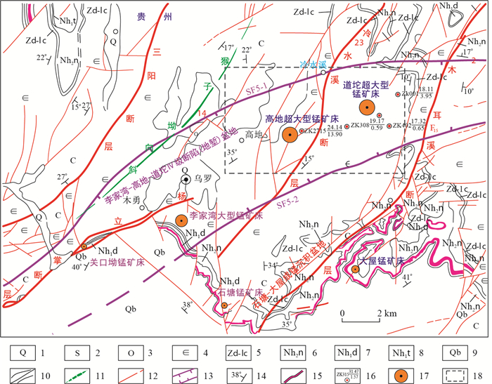
图 1 贵州省松桃李家湾-高地-道坨超大型锰矿床区域地质简图
1.第四系;2.志留系;3.奥陶系;4.寒武系;5.震旦系陡山陡组-留茶坡组;6.南沱组;7.大塘坡组;8.铁丝坳组;9.青白口系;10.角度不整合界线和地层界线;11.向斜轴;12.实测及推测断层;13.李家湾-高地-道坨Ⅳ级断陷盆地;14.地层产状;15.含锰岩系露头;16.钻孔位置及编号-锰品位(%)/矿体厚度(m);17.锰矿床(点);18.矿床三维建模示范区
Figure 1. Regional geological sketch of super-large manganese deposit in Songtao Lijiawan-Gaodi-Daotuo, Guizhou Province
图 2 地质数据多主题数据集市与数据仓库系统体系结构[13]
Figure 2. Architecture of geological data multi-subject data market and data warehouse system
-
[1] 谭永杰.地质大数据体系建设的总体框架研究[J].中国地质调查, 2016, 3(3):1-6. http://www.wanfangdata.com.cn/details/detail.do?_type=perio&id=zgdzdc201603001 [2] 吴冲龙.地质矿产点源信息系统的开发与应用[J].地球科学:中国地质大学学报, 1998, 23(2):87-92. http://www.cqvip.com/qk/94035X/199802/3012871.html [3] 吴冲龙, 刘刚, 田宜平, 等.地质信息科学与技术概论[M].北京:科学出版社, 2014. [4] 刘刚, 吴冲龙, 何珍文, 等.面向地质时空大数据表达与存储管理的数据模型研究[J].地质科技通报, 2020, 39(1):157-163. http://dzkjqb.cug.edu.cn/CN/abstract/abstract9937.shtml [5] 吴冲龙, 田宜平, 张夏林, 等.数字矿山建设的理论与方法探讨[J].地质科技情报, 2011, 30(2):102-108. http://www.wanfangdata.com.cn/details/detail.do?_type=perio&id=dzkjqb201102017 [6] 吴冲龙, 何珍文, 翁正平, 等.地质数据三维可视化的属性、分类和关键技术[J].地质通报, 2011, 30(5):642-649. http://www.wanfangdata.com.cn/details/detail.do?_type=perio&id=zgqydz201105003 [7] 翁正平, 何珍文, 毛小平, 等.三维可视化动态地质建模系统研发与应用[J].地质科技情报, 2012, 31(6):59-66. http://www.cnki.com.cn/Article/CJFDTotal-DZKQ201206011.htm [8] 田宜平, 刘维安, 张夏林.基于等角度变比例投影的矿体轮廓线自动匹配方法研究[J].地质科技通报, 2020, 39(1):175-180. http://dzkjqb.cug.edu.cn/CN/abstract/abstract9938.shtml [9] 陈国旭, 田宜平, 张夏林, 等.基于勘探剖面的三维地质模型快速构建及不确定性分析[J].地质科技情报, 2019, 38(2):275-280. http://www.wanfangdata.com.cn/details/detail.do?_type=perio&id=dzkjqb201902033 [10] 张文彪, 段太忠, 刘彦锋, 等.定量地质建模技术应用现状与发展趋势[J].地质科技情报, 2019, 38(3):1-9. http://www.wanfangdata.com.cn/details/detail.do?_type=perio&id=dzkjqb201903029 [11] Wang Jian, Pan Guitang.Neoproterozoic South China Palaeocontinents:An overview[J].Acta Sedimentologica Sinica, 2009, 27:818-825. http://www.researchgate.net/publication/280949693_Neoproterozoic_South_China_Palaeocontinents_An_overview [12] 周琦, 杜远生, 袁良军, 等.黔湘渝毗邻区南华纪武陵裂谷盆地结构及其对锰矿的控制作用[J].地球科学, 2016, 41(2):177-188. http://www.cqvip.com/qk/94035x/201602/668415639.html [13] 张遂, 周琦, 张平壹, 等.贵州松桃普觉超大型锰矿床主要特征与找矿实践[J].贵州地质, 2018, 35(4):40-49. http://www.wanfangdata.com.cn/details/detail.do?_type=perio&id=gzdz201804007 [14] 覃英, 安正泽, 王佳武, 等.贵州松桃锰矿整装勘查区道坨隐伏超大型锰矿床的发现及地质特征[J].矿产勘查, 2013, 4(4):345-355. http://www.wanfangdata.com.cn/details/detail.do?_type=perio&id=ytgcj201304001 [15] 邵玉祥.三维地质空间点源数据仓库系统构建及关键技术研究[D].武汉: 中国地质大学(武汉), 2009. [16] 马志光, 罗治平.数据仓库, 联机分析处理和联机分析开采研究[J].计算机应用研究, 1999(11):7-11. http://www.cnki.com.cn/Article/CJFDTotal-JSYJ199911002.htm [17] 李日容, 吴冲龙, 邵玉祥.运用多维数据模型实现油气勘探数据集市[J].计算机工程与应用, 2006, 42(14):229-232. http://www.wanfangdata.com.cn/details/detail.do?_type=perio&id=jsjgcyyy200614068 [18] 张夏林, 吴冲龙, 周琦, 等.贵州省道坨超大型锰矿床精细全息三维地质建模研究[J].贵州地质, 2018, 35(4):27-32, 69. http://www.wanfangdata.com.cn/details/detail.do?_type=perio&id=gzdz201804005 [19] 张夏林, 吴冲龙, 周琦, 等.贵州超大型锰矿集区的多尺度三维地质建模[J].地球科学, 2020, 45(2):634-644. http://www.wanfangdata.com.cn/details/detail.do?_type=perio&id=dqkx202002021 [20] 唐丙寅, 吴冲龙, 李新川.一种基于TIN-CPG混合空间数据模型的精细三维地质模型构建方法[J].岩土力学, 2017, 38(4):1218-1225. http://www.wanfangdata.com.cn/details/detail.do?_type=perio&id=ytlx201704037 -


 下载:
下载:


