| Citation: | Tang Shulan. Aster geological mapping based on multi-scale texture classification and mineral recognition[J]. Bulletin of Geological Science and Technology, 2022, 41(3): 311-320. doi: 10.19509/j.cnki.dzkq.2022.0077

|
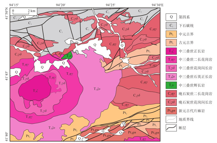
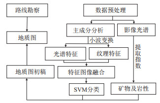
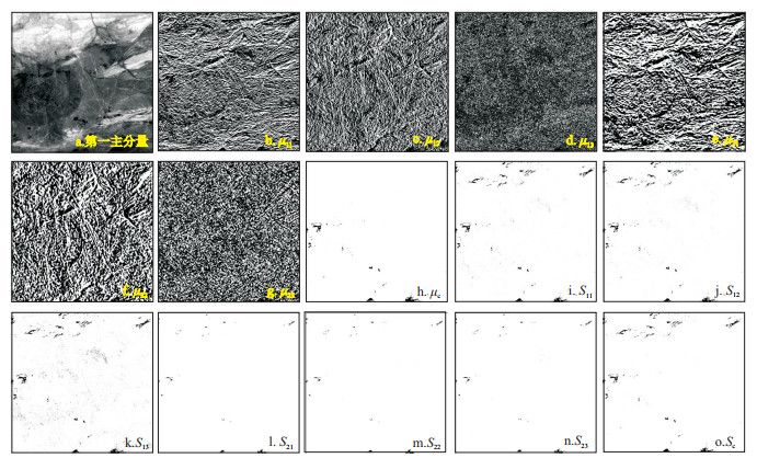
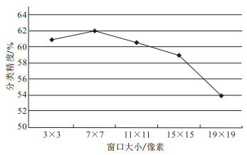
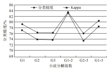
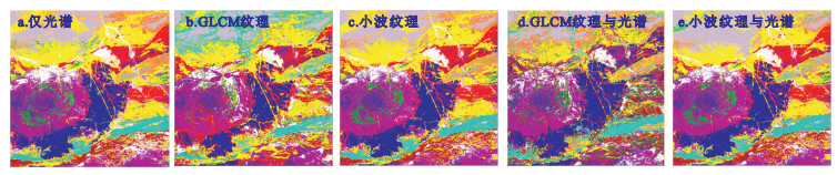
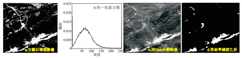
Remote sensing technology has become an indispensable means in geological survey. In order to improve the efficiency and accuracy of geological mapping, a method based on Aster automatic lithology classification combined with the identification of main rock forming minerals is proposed in this study. Firstly, the principal component transform of ASTER data is carried out, the first principal component is selected for multi-scale Haar wavelet decomposition, and the statistical characteristics of wavelet coefficients are taken as texture features to construct multi-dimensional feature space of texture and spectrum; Then, support vector machine is adopted to classify lithology; At the same time, the main rock forming minerals are extracted according to the spectral characteristics; Finally, the main rock forming minerals are superimposed on the classification results, and the lithology mapping is completed in combination with the field investigation background. The confusion matrix results show that the classification accuracy of spectrum- wavelet texture can reach 83.496 2%, which is 2.675 6% higher than that of spectrum-gray level co-occurrence matrix texture classification and 6.3189% higher than that of spectral feature classification. Compared with the maximum likelihood classification method, the classification accuracy of SVM is improved by 6.623 7%. The mineral extraction results indicate that the extraction index of structure can effectively extract muscovite, biotite, calcite, amphibole and other minerals. It can be seen that image processing technology, machine learning algorithm and band operation can be used as effective means of remote sensing mapping in areas with less vegetation coverage.

| [1] |
Hosseinjani Z M, Tangestani M H, Roldan F V, et al. Sub-pixel mineral mapping of a porphyry copper belt using EO-1 hyperion data[J]. Advances in Space Research, 2014, 53(3): 440-451. doi: 10.1016/j.asr.2013.11.029
|
| [2] |
Hisham G, Habes G. Detection of gossan zones in Aridregions using Landsat 8 OLI data: Implication for mineral exploration in the eastern Arabian shield, Saudi Arabia[J]. Natural Resources Research, 2018, 27(1): 109-124. doi: 10.1007/s11053-017-9341-8
|
| [3] |
崔静月, 董玉森, 岳文丽, 等. 基于遥感蚀变信息提取巴林格撞击坑周边铁陨石[J]. 地质科技通报, 2021, 40(1): 209-216. https://www.cnki.com.cn/Article/CJFDTOTAL-DZKQ202101023.htm
Cui J Y, Dong Y S, Yue W L, et al. Extraction of iron meteorites from the Barringer Meteor Crater based on remote sensing alteration information[J]. Bulletin of Geological Science and Technology, 2021, 40(1): 209-216(in Chinese with English abstract). https://www.cnki.com.cn/Article/CJFDTOTAL-DZKQ202101023.htm
|
| [4] |
王俊虎, 武鼎, 张杰林, 等. 基于多源遥感数据的纳米比亚欢乐谷地区千岁兰断裂带识别及新发现[J]. 地质科技通报, 2020, 39(5): 183-190. https://www.cnki.com.cn/Article/CJFDTOTAL-DZKQ202005023.htm
Wang J H, Wu D, Zhang J L, et al. Identification and new discovery of Qiansxuilan fault belt in Gaudeanmus area, Namibia based in the multi-source remote sensing data[J]. Bulletin of Geological Science and Technology, 2020, 39(5): 183-190(in Chinese with English abstract). https://www.cnki.com.cn/Article/CJFDTOTAL-DZKQ202005023.htm
|
| [5] |
Wang R, Lin J Y, Zhao B, et al. Integrated approach for lithological classification using ASTER imagery in a shallowly covered region: The eastern Yanshan Mountain of China[J]. IEEE Journal of Selected Topics in Applied Earth Observations and Remote Sensing, 2018, 11(12): 4791-4807. doi: 10.1109/JSTARS.2018.2879493
|
| [6] |
Aboelkair H, Ninomiya Y, Watanabe Y, et al. Processing and interpretation of ASTER TIR data for mapping of rare-metal-enrichedalbite granitoids in the Central Eastern Desert of Egypt[J]. Journal of African Earth Sciences, 2010, 58(1): 141-151. doi: 10.1016/j.jafrearsci.2010.01.007
|
| [7] |
He J, Harris J R, Sawada M, et al. Comparison of classification algorithms using Landsat-7 and Landsat-8 data for mapping lithology in Canada′s Arctic[J]. International Journal of Remote Sensing, 2015, 36(8): 2252-2276. doi: 10.1080/01431161.2015.1035410
|
| [8] |
Du P J, Tan K, Xing X S. A novel binary tree support vector machine for hyperspectral remote sensing image classification[J]. Optics Communications, 2012, 285: 3054-3060. doi: 10.1016/j.optcom.2012.02.092
|
| [9] |
Mryka H B. Practical guidelines for choosing GLCM textures to use in landscape classification tasks over a range of moderate spatial scales[J]. International Journal of Remote Sensing, 2017, 38: 1312-1338. doi: 10.1080/01431161.2016.1278314
|
| [10] |
Seyedmohammadi J, Navidi M N, Esmaeelnejad L. Geospatial modeling of surface soil texture of agricultural land using fuzzy logic, geostatistics and GIS techniques[J]. Communications in Soil Science and Plant Analysis, 2019, 50(12): 1452-1464. doi: 10.1080/00103624.2019.1626870
|
| [11] |
Li Q Y, Huang X, Wen D W, et al. Integrating multiple textural features for remote sensing image change detection[J]. Photogrammetric Engineering and Remote Sensing, 2017, 83(2): 109-121. doi: 10.14358/PERS.83.2.109
|
| [12] |
Mars J C, Rowan L C. ASTER spectral analysis and lithologic mapping of the Khanneshin carbonatite volcano, Afghanistan[J]. Geosphere, 2011, 7(1): 276-289. doi: 10.1130/GES00630.1
|
| [13] |
Ye M, Routsos D. Wavelet-based color texture retrieval using the independent component color space[J]. IEEE International Conference Image Processing, 2008, 15: 165-168.
|
| [14] |
Regniers O, Bombrun L, Guyon D, et al. Wavelet-based texture features for the classification of age classes in a maritime pine forest[J]. IEEE Geoscience and Remote Sensing Letters, 2015, 12(3): 621-625. doi: 10.1109/LGRS.2014.2353656
|
| [15] |
Wan S A, Chang S S. Crop classification with World View-2 imagery using Support Vector Machine comparing texture analysis approaches and grey relational analysis in Jianan Plain, Taiwan[J]. International Journal of Remote Sensing, 2018, 40(21): 8076-8092.
|
| [16] |
Ma D, Lai H C. Remote sensing image matching based improved ORB in NSCT domain[J]. Journal of The Indian Society of Remote Sensing, 2019, 47(5): 801-807. doi: 10.1007/s12524-019-00958-y
|
| [17] |
Moonon A U, Hu J W, Li S T. Remote sensing image fusion method based on nonsubsampled shearlet transform and sparse representation[J]. Sensing and Imaging, 2015, 16(1): 18-23.
|
Copyright © 2010Editorial Department of Bulletin of Geological Science and Technology

Supported by:
Beijing Renhe Information Technology Co., Ltd.


 DownLoad: