2022 Vol. 41, No. 3

Display Method:
Re-understanding on hydrocarbon accumulation of the Hetaoyuan Formation in Xiaermen area of the Biyang Depression
Luo Jiaqun, Zhang Yonghua, Xie Chun′an, Zhang Lei
2022, 41(3): 1-8. doi: 10.19509/j.cnki.dzkq.2022.0072
Abstract:

The Xiermen area is located in the east of Biyang Depression, and the Xiermen Oilfield has been discovered in this area. The upper part of He-3 Member to the lower part of He-2 Member are completely oil reservoirs, while the upper part of He-2 Member is a reservoir with gas cap, and He-1 Member and Liaozhuang Formation are pure gas reservoirs. After more than 40 years of exploration and development, it is increasingly difficult to find new oil and gas reservoirs in the Xiermen area, and oil and gas exploration has reached a bottleneck stage. In order to further expand the exploration scale and obtain new discoveries, it is necessary to re-understand hydrocarbon accumulation mechanism in this area, providing insights for the next exploration direction. Based on source rock characterization, oil to source correlation, natural gas composition and reservoir profile analysis, combined with the latest exploration reservoir data, our results suggest that the He-2 Member has wide distribution of mudstones, and is characterized by low maturity stage, indicative of good hydrocarbon generation potential. The relationship between hydrocarbon from the Xiaermen area and source rocks in the deep depression is clear, indicating that hydrocarbon is laterally migrated; in other words, the He-2 Member low-maturity oil largely comes from the low-maturity source rocks in the deep depression, and crude oils of the upper and lower part of He-3 Member primarily comes from mature source rocks of the upper and lower part of He-3 Member in the deep depression. The He-2 Member natural gas is low maturity oil-associated gas, which is obviously different from the deep-buried condensate gas, excluding the possibility of migration from deep part along faults. There is a large amount of deep oil and gas resources in the Xiaermen area, but the discovered reserves are limited at present, indicating that there is still a great exploration potential in this area. Therefore, summarizing oil and gas accumulation patterns in the Xiaermen area can not only provide guidance for further oil and gas exploration in this area, but also provide example for further exploration of oil-bearing structures in similar fault depression basins in the eastern China.

Sediment source-to-sink processes of the southeastern Indian Ocean during the Late Eocene-Oligocene and their potential significance for paleoclimate
Fan Qingchao, Xu Zhaokai, Sun Tianqi, Li Tiegang, Chang Fengming
2022, 41(3): 9-19. doi: 10.19509/j.cnki.dzkq.2022.0066
Abstract:

Understanding the paleoclimate responses in Southern Ocean and its surrounding land can help us to better explore the major climate transition mechanisms in geological history and predict the response ofthe earth system to abrupt climate changes in the future, while, there is still a lack of research on the paleoclimatere sponse of the surrounding land in Southern Ocean.Based on the age framework, major, traceand rare earth element compositions of the deep-sea sediments at Site U1516 of the International Ocean Discovery Program (IODP) 369, we determined that the sediments were mainly from the southwest continent of Australia, and then reconstructed the chemical weathering history of the source area on the tectonic time scale.In addition, we combined with the previous research results to discuss the paleoclimate evolution of continents surrounding Southern Ocean during the Late Eocene-Oligocene climate transition period and its response toglobal climate changes and regional paleogeographic changes.During the Eocene-Oligocene transition (e.g., 34.1 to 33.6 Ma and 31.3 to 29.8 Ma), the paleoclimate in the source area was mainly controlled by the significant changes in the paleogeographic pattern of the adjacent area, which was characterized by the climate conditions tending to bedry and cold and the decrease of chemical weathering intensity on the land surface.During the period of 33.6 to 31.3 Ma and 29.8 to 25.2 Ma, the palaeoclimate of the source area mainly responded to global climate changes.In theformer stage, the paleoclimate changed from dry and cold to wet and hot, the intensity of chemical weathering on the land surface increased correspondingly; In the latter stage, the climate maintained in a relatively stable dry and cold state, the intensity of chemical weathering on the land surface is also weak.

Rare earth resources in Laos: Characteristics and the prospects for exploration and development
Lü Liang, Wang Side, Zu Bo, Liu Jiangtao, Zhang Guangqiang
2022, 41(3): 20-31. doi: 10.19509/j.cnki.dzkq.2022.0087
Abstract:

Rare Earth Elements are strategically critical metals of all countries in the world with the medium and heavy REEs are particularly important. A large number of granitoids of different ages are distributed in Laos. In this region, the climate is humid, hot and rainy, resulting strong weathering that is favorable for the formation of ion-adsorbed REE deposits. In order to identify the geological characteristics and distribution of Laos′ rare earth resources, and to analyze its investment and exploitation prospects, this study carried out systematic field investigations and related analyses throughout the country, as well as summarizing the progress of recent REE exploration in the region. The results show that the metallogenic characteristics of REE in Laos are comparable to those in southern China, which belongs to a typical weathered crust elution-deposited rare earth ore(WCED-REO). The orebodies are mainly concentrated in completely weathered layers of granitoid, and the cap layers are relatively thicker than those of southern China. The ore bodies are stratiform and lentoid, with thicknesses of several meters to 20 meters. The average grades of ionic phase rare earth range from 0.4‰ to 0.7‰. Most of them have REE ditributional patterns similar to those of the Xinfeng REE mine in Ganzhou and Jiangxi, which belong to the middle yttrium rich europium type. The rare earth resources of Laos are mainly distributed in the northern parts, such as the Xieng Khouang and Huaphane provinces. The total rare earth resources of the two provinces are estimated to be up to 600, 000 tons. With the opening of Laos′s rare earth policy and the gradual improvement of China′s rare earth strategy, investment in the exploitation of Laos rare earth resources and establishing an overseas strategic base for rare earth resources can support China′s demand for ion-adsorbed rare earth resources in a long-term and stable manner. Meanwhile, it can also facilitate mutual cooperation in mineral resources, significantly contributing the future of both countries.

Cyclic sedimentary record of "red-greyish green" beds in the first Member of Eocene Kongdian Formation(Ek1), Dongying Sag: An example from the Well Wang 46 in Wangjiagang area
Nian Tao, Jiang Zaixing, Liu Huimin, Huang Yiming, Deng Yougen, Meng Jiayi, Li Yang
2022, 41(3): 32-43. doi: 10.19509/j.cnki.dzkq.2021.0072
Abstract:

Vertically superimposed "red-greyish green" assemblages are developed in the first member of the Eocene Kongdian Formation (Kong1 member) in the Dongying sag of the Bohai Bay Basin, showing certain cyclic sedimentary characteristics.Inorder to better understand its depositional process and response to paleoclimate variation, the study took the Wang 46 well, which is located in the Wangjiagang area, as an example.Calibrated by the stratigraphic ages, cyclostratigraphy analysis has been conducted in the formation using cores, logging cuttings and gammaray(GR) curve to reveal its cyclic depositional process.The red beds correspond to flooded lacustrinemud and sandy beach deposited during flood events, while the greyish greenrhythm beds belong to the shallow lacustrine sand beach sediments in the intermittent wet period, and the two types of deposits are superposed with abrupt contacts.The continuous wavelet and spectral analysis of the GR curve indicate that the depositional process of the Ek1 member is controlled by the Milankovitch eccentricity and precession cycles, resulting in the thicknesses of the cyclically deposited formations are 39.4 m and 6.9 m, respectively.The "floating" astronomical time scale of the Ek1 member has been established by the band filtering of the 125 ka eccentricity cycle, and the Ek1 member is found to have 33 eccentricity cycles.The apparent average deposition rate changes between 0.236 m/ka and 0.408 m/ka.The eccentricity and precession cycles have controlled the depositional process: the maximum eccentricities mainly correspond to frequent occurrences of temporary lacustrine, on the contrary, it mainly developed flooded lacustrine.And, the temporary and perennial flooded lacustrine occurred during the periodsof minimum and maximum precessions, respectively.

Sedimentary environment evolution of the Jialingjiang Formation in the Maling area: Evidence from sedimentology and major and trace elements
Ouyang Liuyun, He Qi, Liu Kun, Yang Wei, Mao Kainan
2022, 41(3): 44-53. doi: 10.19509/j.cnki.dzkq.2021.0095
Abstract:

The Maling area is located in Xingyi City, Guizhou Province.It is an idea area to study the evolution of the sedimentary environment in the Early Triassic for its sedimentary strata saddle the Permian and Triassic transition.Based on the integrations of field survey of the Jialingjiang Formation in this area, measured profile data, microscopic observation in the laboratory, and 14 major and trace elements, the evolution of its depositional environment was discussed.Carbonate rocks and clastic rocks are mainly exposed in Maling area, which can be divided into four members.A total of 16 rock samples were collected for analysis.Combined with sedimentary facies, palaeoclimate index (SiO2/Al2O3 ratio), paleosalinity index, paleobathymetric index (CaO/MgO and Sr/B aratio), the following changes are identified in the Early Triassic: ① The abnormally hot and dry climate gradually transitioned to an overall humid climate, which may be the result of the Early Triassic and the biological recovery provided suitable climatic conditions; ②The alternation of shallow sea and deep sea occurred. The first to fourth members of the Jialingjiang Formation are dominated by open platform facies, tidal flat facies, open-limited-open platform facies, and limited platform facies, respectively. The local appearance of bioclasts such as bivalves confirms that the Early Triassic marine environment in this area was abnormally variable and had multiple stages of deterioration-improvement evolution.

Mineralization characteristics and geological significance of Rb-rich granitic pegmatite veins in Shangnan-Danfeng area, eastern Qinling belt
Zhu Weipeng, Song Gongshe, Xu Feng, Yang Wenbo, Wu Peng
2022, 41(3): 54-67. doi: 10.19509/j.cnki.dzkq.2021.0092
Abstract:

Granitic pegmatite is an important source of rare metal minerals, but its mineralization characteristics need to be further studied. This study conducted a combined field geological, indoor microscopic and major-trace elemental investigation on the petrological and geochemical characteristics of the Ziyugou Rb-rich granitic pegmatite veins in the Shangnan-Danfeng area of the eastern Qinling belt. The Ziyugou granitic pegmatites intruded the Danfeng Group. After comprehensive evaluation, 14 Rb-rich granitic pegmatite veins have been identified. On the basis of garnet contents and alteration types, the granitic pegmatites can be divided into five types: microcline granitic pegmatite, garnet-rich microcline granitic pegmatite, greisenized microcline granitic pegmatite, greisenized garnet-rich microcline granitic pegmatite and silicified microcline granitic pegmatite. The Ziyugou granitic pegmatite veins are generally peraluminous, rich in Rb, HFSE and HREE but depleted in Ba, Sr and Ti. Granitic pegmatite veins with little or without alteration usually contain highest Rb contents. Therefore, primary microcline, garnet, secondary muscovite and quartz can be served as key minerals to effectively indicate the Rb fertility of granitic pegmatite veins. The Ziyugou granitic pegmatite veins obviously postdate the Kuanping granite, and both of them exhibit significantly different geochemical characteristics. These features strongly indicate that the Ziyugou granitic pegmatite veins cannot be derived from the magmas forming the Kuanping granite, and their parent rocks were speculated to be located in depth.

Experimental study on sweep pattern of heavy oil reservoirs with variable speed drive based on different geological models
Zhu Yidong, Dai Jianwen, Wang Yahui, Tu Yi, Ma Xiaolin
2022, 41(3): 68-76. doi: 10.19509/j.cnki.dzkq.2021.0048
Abstract:

The heavy oil reservoirs in marine sandstone in the east of South China Sea are generally characterized by loose cementation, strong bottom water, complex interlayer distribution and low recovery degree.Therefore, the existing conventional water flooding experiments can not accurately describe the sweep law of heavy oil in single wells. Based on the geological characteristics of heavy oil reservoir in the PY oilfield, an improved physical simulation experiment of bottom horizontal plate water flooding is designed.It is applied to comprehensively study the sweep law of single well and the recovery degree of heavy oil, considering reservoir rhythm, interlayer development scale and liquid extraction time. The experimentresults are showed as following.①Interbeds developed in homogeneous rhythm and positive rhythm reservoirs transform the original bottom water drive into secondary edge water drive. The longer the well spacing of interbeds is, the stronger the inhibition of bottom water coning is. In addition, the remaining oil located in the lower transition zone, middle to small pore throat in the middle and upper zones and near the interbeds can be effectively displaced by multiple amplitude controll and fluid extraction due to gravity differentiation.In this case, the single well sweep coefficient can be enhanced. The sweep efficiency can be increased by 34.1%-54.9% after adopting 4-stage variable speed to control amplitude and extract liquid during ultra-high water cut stage. Through multiple amplitude control and liquid extraction in z1680 homogeneous rhythm reservoir and z1610 positive rhythm reservoir, the daily oil production can be increased to 2-3 times of that before liquid extraction, and the production effect is good. ②For the reverse rhythm reservoir with a range of 5-10, the permeability difference between the top and bottom is significant. Thus, it is easy to form a high permeability channel at the top. The development length of interlayer and the change of liquid extraction method have little effect on the sweep range. Through multiple amplitude control and liquid extraction, the production effect of z1640 reverse rhythm reservoir is not obvious. The research results can provide solutions for the optimization of liquid production structure and the formulation of liquid extraction methods in heavy oil reservoirs with different geological models.

A fine study on low-rising structure of Panyu YZ gas field group in Pearl River Mouth Basin
Wang Shenghao, Li Li, Wang Yaosen, Yang Xiaojiang, Liu Zhen, Xia Xiaoyan, Jiang Yuting
2022, 41(3): 77-84. doi: 10.19509/j.cnki.dzkq.2022.0086
Abstract:

YZ gas field group in the Pearl River Mouth Basin is located at the edge of the continental shelf, and the gas reservoir is buried deeper than 3 000 m. Structural research faces multiple problems, such as large changes in water depth, large changes in the thickness of the surface low-velocity mudstone, and small-scale shallow gas. It is difficult to predict the depth of gas reservoirs precisely, which brings risks to the implementation of the overall development plan in the gas fields. Aiming at this problem, a research idea of integration of processing and interpretation is proposed: firstly, dense velocity analysis is carried out along the target layer and its upper seismic reflection layer to improve the accuracy of seismic velocity analysis; secondly, in order to eliminate the systematic error of well-seismic velocity, the macro correction of seismic velocity is carried out by using the calibrated velocity of synthetic seismic records, and the corrected velocity is used to perform time-depth conversion to obtain the initial depth structure; the main source of the residual error at the well point is clarified by the correlation analysis method, and with the correlation trend surface as the constraint, the error grid is edited in combination with the residual error of the well to correct the initial depth structure. Finally, a higher-precision depth structure is obtained by correcting the small error at the well location. The practice of gas field exploitation shows that the error between the structural depth predicted by this method and the actual depth of development wells has been reduced from 10-40 m to less than 10 m, which has successfully improved the accuracy of structural prediction, effectively guided the design and implementation of development wells, and reduced the risk of gas field exploitation. For oil and gas fields under similar geological conditions, the detailed study of the structure is not only based on data-driven velocity analysis and seismic imaging, identifying and eliminating the influencing factors of the structure is also the key.

Tectonic characteristics and evolution of typical rift basins in eastern China: A case study in the Gudian area, Songliao Basin
Wang Xiangdong, Wang Ren, Shi Wanzhong, Tang Daqing, Xu Litao, Feng Qian
2022, 41(3): 85-95. doi: 10.19509/j.cnki.dzkq.2022.0089
Abstract:

The Gudian Rift is a favorable area for deep natural gas exploration in the southern Songliao Basin, and it also records rich information on basin evolution and Mesozoic-Cenozoic plate movements in eastern China.By using the well and high-resolution 3D seismic data, combined with regional tectonics, the geological structure and tectonic evolution of the Gudian Rift were investigated.The results show that the Gudian Rift can be vertically divided into basement, lower, middle and upper structure layers.Due to the subduction of the Pacific Plate beneath to the East Asian Plate and the changes in the regional tectonic stress field since the Late Mesozoic, the Gudian Rift experienced syn-rift, transition, post rift and tectonic inversion periods.The Gudian fault was initially formed from six fault segments in syn rift period(depositional period of the Huoshiling and Shahezi Formations) and the isolated fault segments with different strikes then grew and connected to a unified boundary fault in the late rifting stage(depositional period of the Yingcheng Formation).Afterwards, extensive and intense transtensional activities occurred during transition(depositional period of the Denglouku and Quantou Formations) and depression periods(depositional period of the Qingshankou, Yaojia and Nenjiang Formations), and strong inversion and segmental thrust activities occurred during inversion period(end of the depositional period of the Nenjiang Formation), respectively.This study provides references for the investigation of tectonic activity and evolution in the Songliao Basin and eastern China, and further guides oil and gas exploration.

Discussion on characteristics of mudstone and shale
Cai Yi, Zhu Rukai, Wu Songtao, Liu Chang
2022, 41(3): 96-107. doi: 10.19509/j.cnki.dzkq.2022.0084
Abstract:

The types of fine-grained sedimentary rocks are complicated because their definition is based on the concept of texture grain size, which lacks effective constraints on mineral composition; In addition, different scholars have described the fabric phenomena at different scales, which altogether mades fine-grained sedimentary rocks lack of scientific and systematic classification. To analyse distinguish the characteristics of mudstones and shales, a large number of investigations and surveys were conducted in the textbooks of sedimentology and related literature at home and abroad. It is found showing that since the conception of fine-grained sediments (size less than 62.5 μm) appeared in the 1930s, it was accepted widely by the researchers, and based on particle size, most scholars generally appreciated it that the fine-grained sediments could further be divided into clay grains (size less than 3.9 μm) and silt grains (size between 3.9 μm and 62.5 μm). However, domestically and internationally, the particle size of fine-grained sediment "mud" (mud grains) was divided differently. Generally, scholars in Europe and America defined the mud as a particle size less than 62.5μm, including clay and silt grains. In our country, the particle size of mud corresponded to that of clay grains, which was less than 3.9μm, mainly following the former Soviet Union′s sedimentary scheme, since the 1950s. This divergence is also the fundamental reason for the confusion of concepts. In general, the consolidated mudstone has the same grain size structure and composition as shale, but does not have the "lamination" or "fissile" structural characteristics of shale. Dialectically speaking, "lamination" emphasizes the stratigraphic vertical differences formed by sedimentary processes, while "fissile" refers to the mechanical weaknesses formed by weathering during diagenetic processes. In terms of the mineral composition of mudstone and shale, there are fine-grained mixed sedimentation effects of quartz and feldspar siliceous minerals, clay minerals and carbonate minerals. Therefore, it is necessary to comprehensively classify fine-grained sediments into lithologies and lithofacies based on sedimentary genesis, combined with structural characteristics, mineral types, abundance of organic matter, and particle sources comprehensively. Practice has shown that the development and utilization of shale oil and gas require the integration of geology and engineering, and distinguishes the difference in characteristics of mudstone and shale is of great significance to the optimization of pay zones.

Vertical heterogeneity and the main controlling factors of the Upper Ordovician-Lower Silurian Wufeng-Longmaxi shales in the Middle Yangtze region
Wang Chuan, Dong Tian, Jiang Shu, Zhang Yuying, Yang Liuqing, Liang Xing, Wang Gaocheng
2022, 41(3): 108-121. doi: 10.19509/j.cnki.dzkq.2021.0053
Abstract:

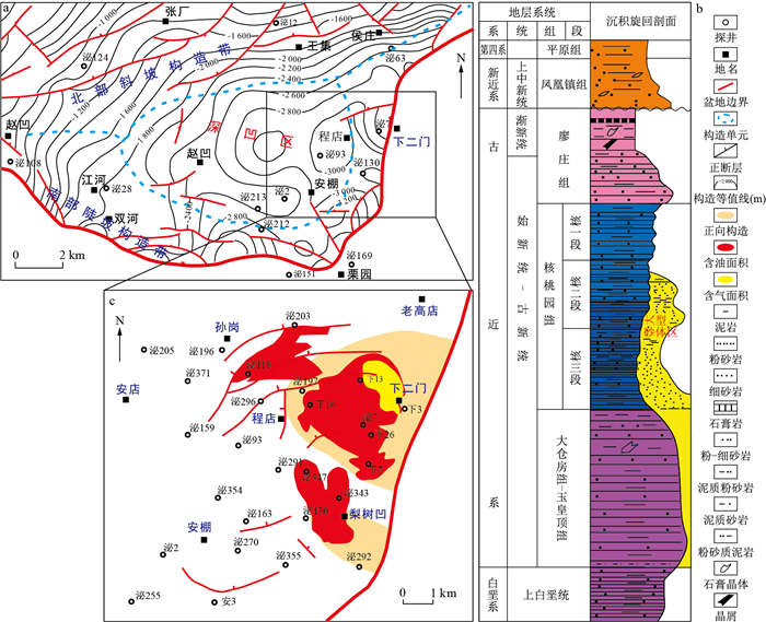
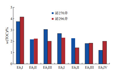
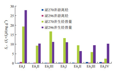
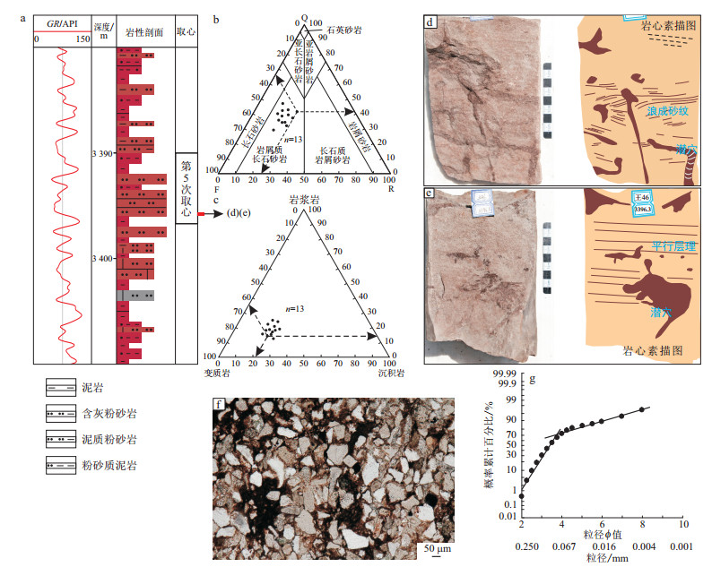
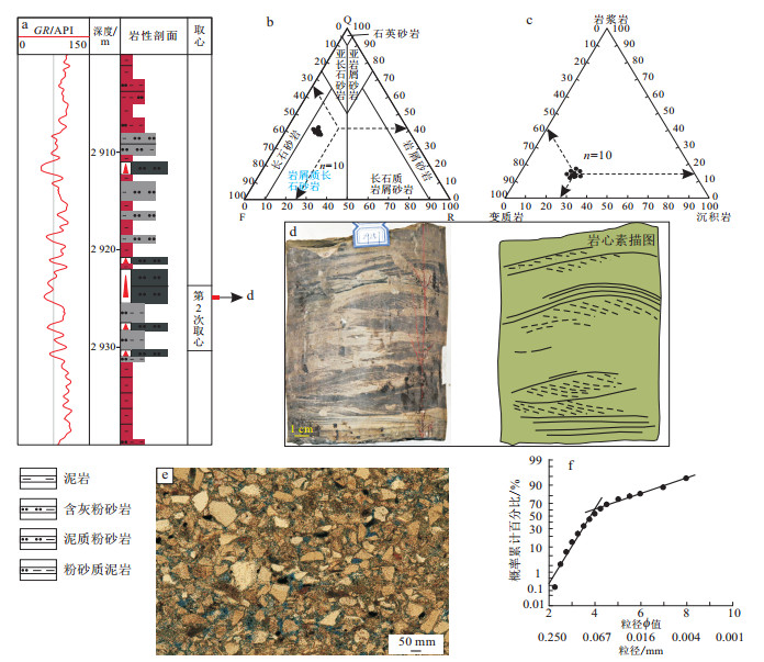
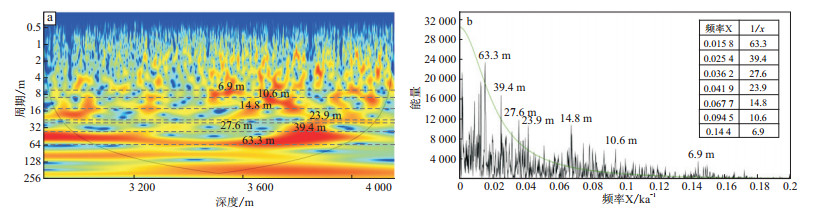
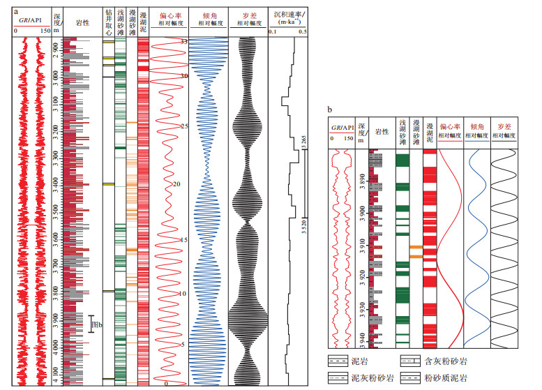
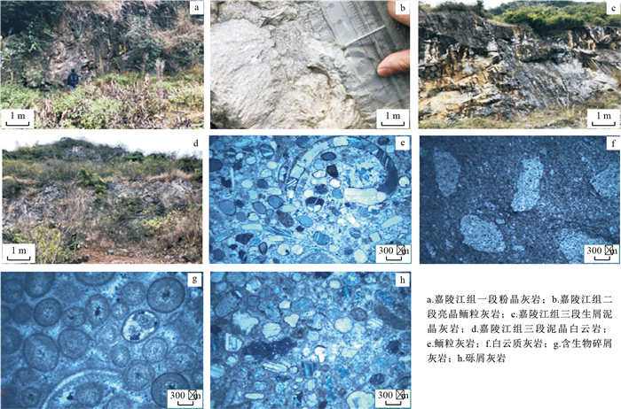
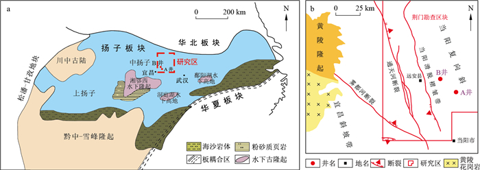
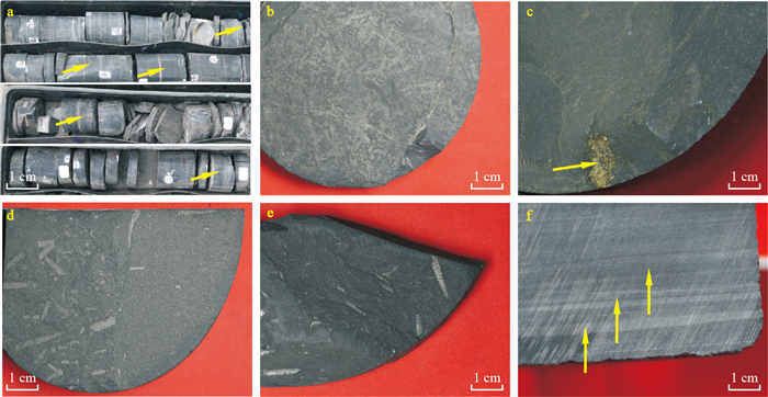
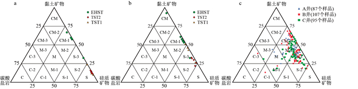
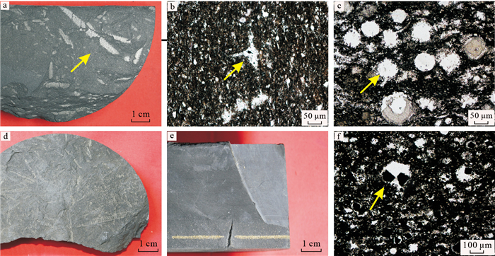
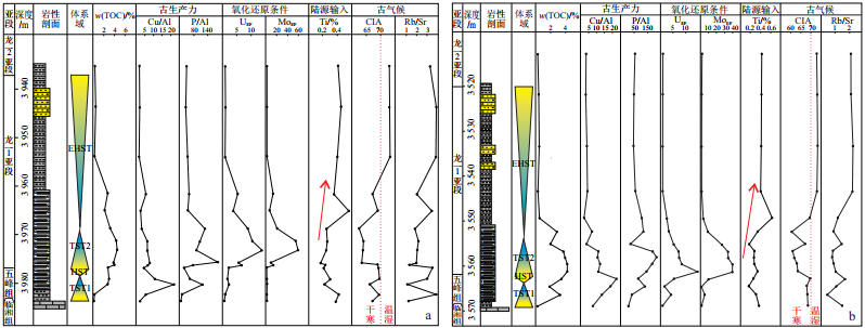
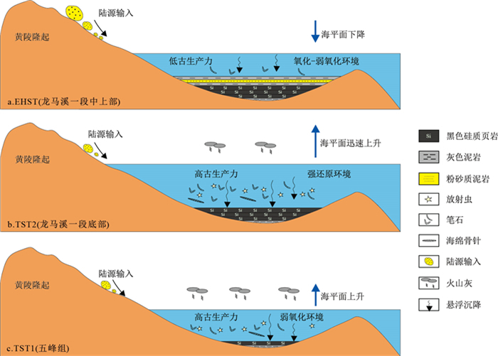
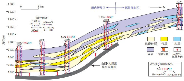
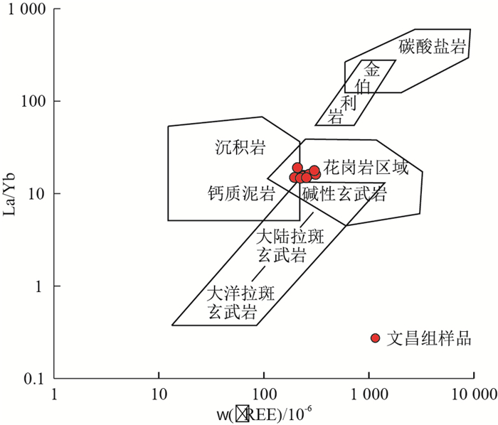
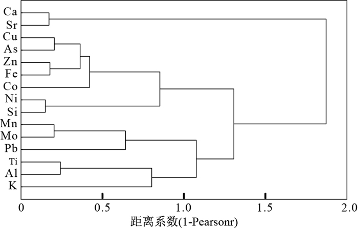
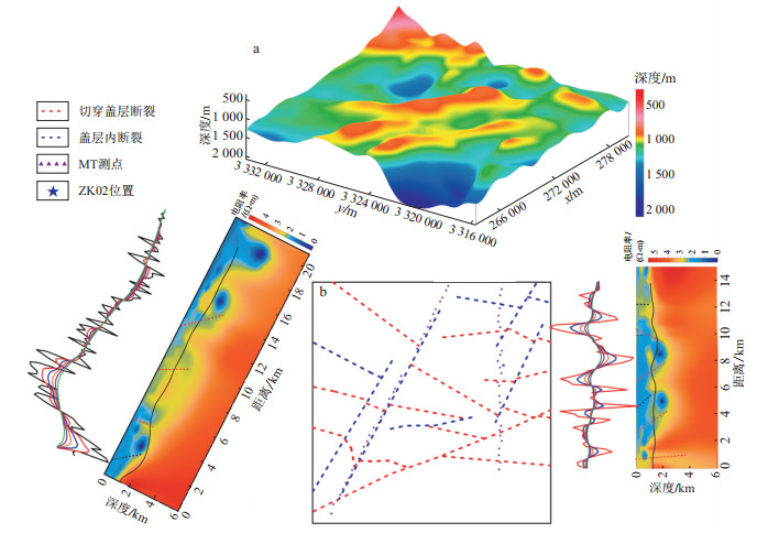
The Upper Ordovician-Lower Silurian Wufeng-Longmaxi shales in the Middle Yangtze area have strong vertical heterogeneity, affecting the gas-bearing capacity of shale reservoirs and the fracturing ability.This study integrates wire-line logs, drilling cores, thin section observations, total organic carbon content, X-ray diffraction mineralogy measurement, and major, trace elements measurement.Under the stratigraphic sequence framework in the study area, the vertical variation of TOC content, mineralogical composition and shale lithofacies were studied.Combined with geochemical proxies for paleoclimate and paleoenvironmental conditions, the main factors controlling vertical heterogeneity were discussed.The results show that the Wufeng-Longmaxi shales have two 3rd-order sequences.The Wufeng Formation is divided into the transgressive systems tract(TST1) and high stand systems tract(HST), and the Longmaxi Formation is divided into the transgressive systems tract(TST2) and the early high stand systems tract(EHST).During the transgression period, the shale has high silica content, low clay content, and high organic carbon content, and mainly developed siliceous shale facies and clay-bearing siliceous shale facies.In the early high-stand systems tract period, shale developed silty bands and lenticular bedding, with high clay content, and low organic carbon content, and mainly developed siliceous-clay mixed shale lithofacies.The vertical changes of paleoclimate indicators(CIA, Rb/Sr), paleo-productivity indicators(Cu/Al, P/Al), redox environmental indicators(MoEF, UEF), and terrestrial input(Ti, Zr) indicators indicate a high productivity, anoxic sedimentary environment, low terrestrial input and relatively dry and cold climate conditions for the transgression period, while during the high-stand systems tract deposition, the study area has low productivity, oxic-dysoxic environment, high terrestrial input and relatively warm and humid climateconditions.The paleo climate, paleo productivity, redox conditions, volcanic activity, terrestrial input and bottom currents are the main factors controlling the stratigraphic heterogeneity of the Wufeng-Longmaxi shales in the study area.Finally, by comparing with some parameters of the shale in the Upper Yangtze region, it is found that the study area shows the differences in deeper burial depth, thinner organic shale, lower gas content and more brittle mineral content.

Sealing model of tight gas reservoirs in the edge of Claraton Basin: A case study from the first Member of Lower Shihezi Formation in Hangjinqi area of the northern margin of the Ordos Basin
Zhang Wei, Cao Qiang, Lu Yongchao, Li Liang
2022, 41(3): 122-131. doi: 10.19509/j.cnki.dzkq.2022.0075
Abstract:

Gas and water distribution of large-scaled tight sandstone gas reservoirs in the margin of typical craton basin is generally much more complicated than that in the center of the basin, and there are various types of traps, therefore, the updip sealing models of gas reservoirs is controversial.This study takes the Permian gas reservoirsof the first Member of Lower Shihezi Formation (He-1 member)in Hangjinqi area of the northern margin of the Ordos Basin as an example, and aims to investigate the differential distribution characteristics, including sandbody thickness, lithofacies association, sandbody superimposition, reservoir physical properties and transverse connectivity of typical channels in the He-1 memberat different locations. The results suggest three types of river depositional models, including shallow-water braided river model in the western gentle slope zone, alluvial fan-braided river model in the central steep slope zone, and deep-water braided river model in the eastern slope break zone. The three depositional models control the difference of channel updipsealing conditions. Based on the relationship between updip reservoir variation and trap types, three models of natural gas migration and accumulation are proposed aslithologic sealing model in the western gentle slope zone, strata coupled with lithologic sealing model in the central steep slope zone, and transitional model of lithologic sealing-trap accumulation in the eastern zone.It is concluded that the upward sealing conditions under these three migration and accumulation models constitute the boundary of the large-scaled continuous reservoir-forming area of He-1 memberin the northern margin of the Ordos Basin, and also control the distribution of different traps and gas enrichment in the Hangjinqi area.

Discussion on the variation characteristics of paleo-water-depth of lake basin under the background of forced regression: An example in the Early Oligocene of west of Weixi'nan Sag
Zou Min, Sun Li, Wang Peng, Yan Shumei, He Weiling, Zhao Gang, Lu Zhiyuan
2022, 41(3): 132-139. doi: 10.19509/j.cnki.dzkq.2022.0070
Abstract:

Forced regression is common during geological history, but due to mismatched sources andsupplies, there are fewer geological records and fewer research cases. Taking the 4th member of Weizhouformation in the Early Oligocene of Weixi'nan Sag in the Beibu Gulf Basin in the northwest of the South China Sea as the research object, the restoration of paleo-water-depth is carried out by using the seismic reflectionstructure method, the variation characteristics of paleowater depth under the background of forcedregression are clarified, and the restoration method of paleowater depth by using the delta progradationstructure method is further discussed. The research shows that during the deposition of 4th member of Weizhou Formation in the Early Oligocene, the provenance of Weixi'nan Sag was sufficient, a large incisedvalley was developed around it, and a large oblique progradation reflection structure was developed in thesag, which has typical Forced Regression characteristics, forming a large-scale forced regression systemtract. Through the fine dissection of typical progradation sections, six typical progradation reflection layersare identified. Combined with seismic, drilling and compaction coefficient, the paleo-water-depth of thelake basin is restored to be 111.2-286.5 m, with an average of 218.5 m. From the edge of the paleo-laketo the center, the height and dip angle of the progradation layers increase slowly and then decrease rapidly.In terms of water depth, it is about 230 m in the early stage, gradually deepened to about 280 m in themiddle and late stage, and rapidly decreased to 110 m in the last stage, with a change range of 61.5% comparedwith the maximum water depth; The dip angle of progradation layer is about 10° in the early stage, gradually decreases after reaching 14.5° in the middle stage, and changes rapidly to 2.9° in the final stage, with a change range of 79.8%. Combined with the regional geological research, it is considered that thegeological period experienced during the deposition of 4th member of Weizhou Formation is less than 2 Ma, and the paleowater depth and paleodip angle of progradation layers change rapidly and violently in lessthan 2 Ma, which is basically consistent with the characteristics of forced regression, which confirms theresponse characteristics of seismic reflection structure. Further, the feasibility and future research directionof paleo-water-depth restoration using delta progradation structure are discussed from the perspectiveof theoretical model simplification and restoration parameter optimization. The research results provide animportant reference for enriching the understanding of the variation characteristics of paleowater depth underthe background of forced regression.

Application of conventional logging and gas logging data to fluid identification of carbonate reservoirs in K reservoir of H Oilfield
Zhang Pan, Liu Hongqi, Wang Weijun, Xin Jionglong, Sun Yangsha
2022, 41(3): 140-149. doi: 10.19509/j.cnki.dzkq.2021.0062
Abstract:

K reservoir is an important oil and gas producing layer of H oilfield in the Middle East, Iraq. The reservoir space is mainly matrix pores and dissolved pores, with a wide range of permeability and poor correlation between porosity and permeability. The reservoir thickness is large, and the stratigraphic heterogeneity is very strong; therefore, it is poor quality to identify carbonate reservoir fluid properties only relying on conventional logging data and traditional logging evaluation methods. Aiming at this problem, the fluid identification work of K reservoirin H oilfield was carried out. By analyzing conventional logging data, it is found that the ratio of deep to shallow resistivity can better distinguish water from hydrocarbon. Based on analyzing morphological characteristics of the total hydrocarbon curve and corresponding reservoir fluid properties, it is found that the gas curve has obvious differences in the morphology of different fluid properties, so it is considered to further classify water and hydrocarbon by using gas curve. It is found that the ratio of heavy hydrocarbon tohydrocarbon gas density index can better classify oil-water layer and water layer. In order to quantitatively characterize the identification process, the identification method of water-oil-water layer gas measurement curve (ECR1) is established. ECR1 greater than 0 is oil-water layer, otherwise, it is water layer. Based on gas wet index, light hydrocarbon ratio and excavation effect, the identification method of gas-reservoir gas measurement curve (ECR2) is established. ECR2 higher than 0 isgas reservoir, and vice versa. The application of this model to 38 small layers in 13 wells of K reservoir in H oilfield shows that the recognition coincidence rate reaches 81.58%, and the recognition accuracy is high, meeting the actual needs of study area. The established ECR model has achieved good application effect in K reservoir of H oilfield, which can provide a certain reference for the subsequent exploration and development of this area, and also provide a reference for fluid identification of similar carbonate reservoirs worldwide.

Numerical simulation of diagenetic evolution and porosity prediction in eastern area of Wushi Sag
Yang Li, Qin Lijuan, Peng Zhichun, Gan Yongnian, Chao Caixia
2022, 41(3): 150-157. doi: 10.19509/j.cnki.dzkq.2022.0069
Abstract:

The commercial oil fields discovered in the eastern area of Wushi Sag in recent years are mainly formed in a complex continental sedimentary environment, which was influenced by the tectonic movement, sedimentation and diagenesis.The reservoir in the oilfields of the study is characterized by a strong heterogeneity, complex reservoir seepage mechanism, which affects the development program Therefore, the analysis of the main controlling factors of the reservoir physical properties is extremely necessary, which can help the decision-makers to predict the sweet spot area theoretically and technically.In this paper, the method of numerical simulation of diagenetic evolution was adopted, in which the diagenesis index was obtained by the simulation of vitrinite reflectance, paleotemperature, smectite content in illite/smectite mixed layer, and quartz autogenesis increase based on the diagenetic environment parameter and chemical kinetic model.Moreover, the diagenetic stage and the lateral distribution of porosity were predicted based on the change of the diagenetic index.The results show that the diagenesis stage in the eastern area of Wushi Sag is the middle diagenesis stage A1-A2, and the diagenesis in the central sag is strong and gradually weaken.Combining the understanding of sedimentary and diagenesis, establishing the porosity prediction model and predicting it in horizon, the results indicate that: Following the source of sedimentary, the reservoir physical properties worsen with increasing burial depth, which is consistent with the change trend of diagenesis.

LA-ICP-MS cassiterite U-Pb ages and the geological significance of the Maogaitu Sn ore spot in Hexigten Banner, Inner Mongolia
Jiang Binbin, Zou Tao, Zhu Xinyou
2022, 41(3): 158-165. doi: 10.19509/j.cnki.dzkq.2022.0068
Abstract:

The Maogaitu Sn ore spot in Hexigten Banner, Inner Mongolia is a newly discovered ore spot in the south section of Greater Khingan Range by Beijing Institute of Geology for Mineral Resources. It is tectonically located in the polymetallic metallogenic belt in the south centralsection of Greater Khingan Range, and the mineralization is characterized by cassiterite-quartz veins. Ore minerals of the ores are dominated by cassiterite with trace amounts of sphalerite, galena, chalcopyrite and silver minerals, while gangue minerals are mainly quartz and fluorite. As discovered recently without detailed studies, the genesis and age of the Maogaitu Sn ore spot are not clearly addressed. A number of tin polymetallic deposits are documented to develop in the polymetallic metallogenic belt in the south central section of Greater Khingan Range. The ages of these tin polymetallic deposits are constrained to be mostly around the Early Cretaceous, and to be genetically related to the Early Cretaceous granite. In order to address the relationship of the Maogaitu Sn ore spot with regional metallogeny, we obtained the age of the Maogaitu Sn ore spot by using LA-ICPMS U-Pb isotopic dating of cassiterite from a quartz vein-type tin ore sample. The results show that the sample yields a 207Pb/206Pb-238U/206Pb concordant age of (130.2±3.4) Ma (MSWD=2.9), similar to the timing of the major tin mineralization event in the region. The new findings imply that the middle and south sections of Greater Khingan Range could be good targets for Sn polymetallic exploration.

REE characteristics and geological significance of mudstones from Wenchang Formation in eastern Yangjiang Sag of Pearl River Mouth Basin
Shi Chuang
2022, 41(3): 166-172. doi: 10.19509/j.cnki.dzkq.2022.0067
Abstract:

The REE in sedimentary rocks have strange chemical stability and can well record the original sedimentary message.In order to explore the material source, tectonic setting and sedimentary environment of the Wenchang Formation in Eastern Yangjiang Sag, the REE geochemical characteristics of Wenchang Formation mudstones from well Y-1 in the study area were systematically analyzed.The results show that the concentrations of REE in mudstones of Wenchang Formation is high, yielding relatively enrichedof LREE, obviouslyEu negative anomaly and weak Cepositive anomaly.The material of Wenchang Formation is mainly source fromgranite with a small amount of sedimentary rocks, and thus the sedimentary source area is likely to be the passive continental margin tectonic setting.TheCeanom and δCe indicate that the water was under reducing conditions, which could provide well preservation conditions for the development of high-quality source rocks. Furthermore, the temporal variations of redox conditions are consistent with the variation trend of TOC of mudstone in Wenchang Formation.

Application of horizontal development wells in reserves evaluation and development of offshore oilfields
Hong Hao, Dai Jianwen, Wang Hua, Song Gang, Huang Yujin, Liu Zhen, Liao Yi, Tu Yi
2022, 41(3): 173-179. doi: 10.19509/j.cnki.dzkq.2022.0076
Abstract:

In the early stage of offshore oilfield development, due to the lack of drilling, limited data admission, and lack of dynamic data, there is great uncertainty in the understanding of oilfield reserves. With increased degree of development, production is usually inconsistent with reserves, and reserve re-evaluation is an important way to resolve this problem. In order to improve the development efficiency and reduce costs, offshore oilfields are dominated by horizontal wells, resulted in limited data acquisition. Therefore, new horizontal well data has become the key to obtainnew geological reservoir parameters and improve the accuracy of reserve estimation. In order to further obtain reliable reserve evaluation results and resolve the dynamic and static contradictions of the oilfield, based on analyzing the main controlling parameters of reserve change in the Pearl River Mouth Basin, this study fully excavates the role of horizontal development wells in improving the accuracy of primary controlling parameters.Our results show that the oil-bearing area and effective thickness are the most uncertain in the reserve assessment, and cause the change of reserves. Horizontal development well is critical in improving the production capacity of the oilfield, determining the lower limit of effective thickness, investigating microstructure, and identifying lithological boundary and fluid interface, etc. In the case of limited data access, the utilizationof horizontal development wells can effectively improve the accuracy of major controlling parameters to obtain relatively reasonable geological reserves, and solve the dynamic contradictions of oilfield production. It also points out the direction for late exploration and development of oilfields. Application examples from multiple oil fields in the eastern South China Sea also confirm this understanding.

Characteristics and geological significance of biomarkers from the Paleogene source rocks in Bozhong Sag, Bohai Bay Basin
Huang Qian, Chen Rongtao, Peng Xiaobo, Li Xinqi, Wang Ning
2022, 41(3): 180-192. doi: 10.19509/j.cnki.dzkq.2022.0085
Abstract:

The Bozhong Sag is located in the central and eastern part of the Bohai Bay Basin, and source rocks of the first and third Member of the Paleogene Shahejie Formation (E2s1 and E2s3) and the third Member of the Donying Formation (E3d3) are mainly developed, indicative of good oil and gas exploration prospects. Previous studies on organic geochemical characteristics of the Bozhong Sag are mainly based on cutting samples, and study on biomarker characteristics using core samples is insufficient. By utilizing both core and cuttings samples, this study integrates organic carbon, rock pyrolysis, chloroform bitumen "A", saturated hydrocarbon chromatography-mass spectrometry and other organic geochemical analysis.Organic matter abundance, type, maturity, source materials and depositional environment of the E3d3, E2s1 and E2s3 source rocks in the Bozhong Sag were studied, and the geochemical characteristics and depositional factors of the three source rocks were studied.The combination characteristics of typical biomarker compounds to distinguish the three source rocks are established, in order to provide a theoretical basis for further clarifying the development pattern and spatial distribution of high-quality source rocks in this area, which is beneficial to the exploration of oil and gas in this area.The results show that the hydrocarbon generation potential of the three source rocks is different, where the generation potential is as E2s3>E2s1>E3d3. The E2s3 source rock has the highest organic matter abundance, typeⅠand Ⅱ1 kerogen, and is currently in the mature stage. The E2s1 is medium to good source rock, with organic matter type Ⅱ1 and Ⅱ2, and is also inmature stage. The E3d3 is a medium source rock, with organic matter typeⅡ1 and Ⅱ2, and is in the stage of low maturity to medium maturity. The biomarker parameters, including Pr/Ph value, gammacerane index, C27-C28-C29 regular sterane content, 4-methylsterane index and other parameters indicate that the source material input and depositional environment are the main factors controlling the different development of three lacustrine source rocks. The input of freshwater algae sources and good preservation conditions are the keys to the development of high-quality source rocks in the E2s3. The input of low-level aquatic organisms and strong reducing preservation conditions are the keys to the development of high-quality source rocks in the E2s1. Mixed source input and good preservation conditions are the key to the development of high-quality source rocks in the E3d3.

Experimental study on EOR of offshore heavy oil reservoir in high-ultra-high water cut stage
Zhang Wei, Dai Jianwen, Wang Yahui, Tu Yi
2022, 41(3): 193-199. doi: 10.19509/j.cnki.dzkq.2022.0065
Abstract:

To explore the mechanism of enhancing the recovery degree of remaining oil in heavy oil reservoir with different liquid extraction methods in high and ultra-high water cut stage, a displacement experiment of heavy oil reservoirs in marine sandstone under different extraction methods and crude oil viscosity was designed.One dimensional displacement simulation experiment was carried out by constructing interior long core physics to study the effects of different liquid extraction methods and crude oil viscosity on EOR in high and ultra-high water cut stage.Then, the distribution of remaining oil under different water injection methods was studied by combining nuclear magnetic resonance imaging with T2 spectrum. The research shows that the recovery degree for the 100 mPa·s crude oil can be increased by about 11% compared with constant low-speed drive.Taking the water cut is more than 99% as a termination condition for displacement completion, the recovery degree of oil reservoir in high water cut stage is the highest through multiple amplitude control and liquid extraction. When it reaches ultra-high water cut stage for core low-speed water flooding, the core saturation showing in NMR image decreases obviously. With the progress of displacement, porosity component decreases gradually, that is, remaining oil decreases gradually.Compared withone large liquid extraction, multiple liquid extraction shows better effect on the production degree of different pore sizes than during the high water cut stage. Micropores, pores and mesopores are affected with different degrees, and the overall recovery degree is increased by 17.01%. The development of small and medium pores results in the increase of recovery degree by 13.31%, accounting for 78.2%of the increase range.In the ultra-high water cut stage, the dominant seepage channels are easily formed under the condition of both one large liquid extraction and multiple liquid extraction, and the oil recovery degree of multiple liquid extraction is 9.2% higher than that of one large liquid extraction. Under different liquid extraction methods, the medium pore makes main contribution to improve the recovery degree, accounting for 97.2% of the increase range, and the sweep degree of micro pore wave is the smallest. The research results indicate that multiple amplitude control and liquid extraction technology can provide technical support for EOR of heavy oil reservoir in high and ultra-high water cut stage.

Experimental study on Brazilian split test and acoustic emission characteristics of high temperature granite under different cooling methods
Wang Yachao, Dou Bin, Yu Yong, Zheng Jun, Tian Hong, Liu Hejuan
2022, 41(3): 200-207. doi: 10.19509/j.cnki.dzkq.2021.0028
Abstract:

High-temperature rock cooling can occur in the whole process of the drilling, fracturing, and heat exchange during the geothermal energy exploitation in hot dry rock. To reveal the evolution law of rock damage, based on the Brazilian splitting test and acoustic emission technology, the effects of different high temperatures and cooling methods on the tensile properties of granite were studied. The results showed that: ①The tensile strength of granite decreases with increasing temperature from 25℃ to 600℃, and the temperature threshold, at which it decreases greatly, is advanced to 200℃ after cooling with water. After 500℃, the tensile strength is more sensitive to water cooling. ②When the load reaches the peak value, the cumulative ringing count of acoustic emission suddenly increases, and the fracture zone forms in the rock sample. Under the influence of water cooling, the ringing count peak value and energy peak value of the rock sample decrease, which indirectly reflects that the internal cracks of the rock are more developed, and both of their decrease range is larger at 200~300℃. The granite is more sensitive to heat treatment at 300℃ and after 500℃. ③With the increase in temperature, the fracture surface of granite changes from flat to rough and tortuous, from brittle to ductile; Cooling in water promotes rock fracture and advances the temperature range from brittleness to ductility. The research results provide a theoretical reference for the stability evaluation of high-temperature rocks in geothermal exploitation.

Influence of different rock-soil fabrics on carbonate weathering carbon sink flux in karst regions
Luo Weijun, Yang Kaiping, Wang Yanwei, Chen Jia, Jia Yuhe, Wang Shijie
2022, 41(3): 208-214. doi: 10.19509/j.cnki.dzkq.2022.0088
Abstract:

The karst areas in southern China are characterized by a high rock exposure ratio and shallow and unevenly distributed soil layers.How this special geotechnical fabric affects the hydrological process is of great significance for the accurate estimation of carbonate weathering carbon sink flux.Hydrochemical runoff is a commonly used method for calculating carbonate weathering carbon sink flux at the watershed scale, and basin area and discharge, as two important parameters, are often difficult to accurately obtain in karst areas.To overcome this problem, we designed a rock-soil fabric simulation test site, including different rock-soil ratios(1:1 and 4:1) and soil thicknesses(5, 20, 100 cm) at the Puding Karst Ecosystem Research Station, Chinese Academy Sciences.The effects of rock exposure and soil layer thickness on hydrological processes and carbonate weathering carbon sink flux were quantitatively studied by monitoring the flow and hydrochemistry during a hydrological year.The results show that the average carbonate weathering carbon sink flux is 17±3 gC/m2/a, which is controlled by the leakage amount and accounts for 95% in the rainy season(from May to October); The influence of the rock exposure ratio(between the two groups of rock fabric) on the leakage amount is up to 14%, and the infiltration coefficient increases with increaseing of rock exposure ratio; The effect of the soil layer thickness on seepage is only 1%-2%.In addition, it is found that the correlation between the infiltration coefficient and carbonate weathering carbon sink flux is the most significant by analysis the observed data of 8 field basins from previous studies.The infiltration coefficient is the main factor affecting and controlling the carbonate weathering carbon sink flux, which is due to the geological background of different rock and soil fabrics in the karst area.At the same time, the influence may change with the rainfall variation, that is, the infiltration coefficient is not constant.

Influence of differential frictional resistance around rectangular pipe jacking on longitudinal horizontal displacement of strata
Lan Bin, Zhang Peng, Zhang Yunlong, Yan Xuefeng
2022, 41(3): 215-221. doi: 10.19509/j.cnki.dzkq.2022.0031
Abstract:

In the process of rectangular box jacking, the friction resistance around the pipe is an important factor that causes the disturbance of the surrounding soil. To predict the influence of rectangular pipe jacking construction on stratum displacement more accurately, the calculation formula of horizontal displacement of soil is established based on the Mindlin solution of elastic mechanics, assuming the state of 'U' shaped mud sleeve combined with the stress analysis of pipe joint and the law of mud movement, and the vertical-horizontal displacement of stratum caused by additional stress on the front and friction resistance around the pipe is calculated. Finally, it is compared with the measured values of a rectangular box jacking project in Suzhou. The results show that before the pipe jacking head passes through a certain fracture, the effect of the additional stress on the surrounding soil is greater than the differential friction resistance around the pipe.However, after crossing the section, the cumulative effect of the latter is gradually greater than the former due to the increase inthe number of pipe segments and the "pull" effect of the friction resistance around the pipe jacking that haspassed through. The calculated value in the case of differential friction resistance is closer to the measured value than that in the case of uniform friction resistance, and the prediction effect is better.

Prediction of foundation bearing capacity based on grey Markov model
Chen Feiyu, Dong Lifei, Wang Miao, Wang Fanshun
2022, 41(3): 222-227. doi: 10.19509/j.cnki.dzkq.2022.0073
Abstract:

Foundation is the foundation of engineering construction, and its bearing capacity calculation and prediction are very critical indetermining the safety and stability of the superstructure of the building project. To realize the foundation bearing capacity prediction with small data volume, short period, and higher accuracy, this paper establishes the gray Markov prediction model to predict the foundation settlement under the action of fixed load and clarify the base bearing capacity, based on the foundation static load test data, the gray model for calculation, and Markov optimization. Meanwhile, the model is compared with the traditional gray GM(1, 1) model and exponential curve fitting model to analyze the advantages and disadvantages of the three models. The results show that in case one, the bearing capacity of the foundation underthe static load test is intact, and the average relative errors between the predicted and measured values of the gray Markov model, GM(1, 1) model, and exponential curve model are 1.55%, 3.80% and 10.22% in order, and the gray Markov model has the highest accuracy and fits the static load test of the foundation better, which can clarify the bearing capacity of the foundation accurately and effectively; in case two, the foundation The average relative error between the predicted and measured values of the gray Markov model before the damage occurred under the static load test was only 0.5%, and the prediction effect was good. When the damage occurred, the settlement of the foundation increased rapidly, and the relative error between the predicted and measured values of the model at the loading point was abnormal and increased to 26.29%, so that the load of the loading sequence at the first level before the damage could be judged as the ultimate bearing capacity of the foundation. Using this model to guide the foundation static load test, the number of static load tests can be appropriately reduced at adjacent test points under the premise of ensuring construction safety, saving the construction cost of the project, and providing a new calculation tool for the information foundation static load test.

Mobilization of fluoride in sediments at high fluoride area enhanced by microorganisms
Zhang Yuxian, Gan Yiqun, Zhou Xiaoyu, Jiang Cuijie, Gao Xubo, Li Chengcheng
2022, 41(3): 228-235. doi: 10.19509/j.cnki.dzkq.2022.0078
Abstract:

As one of the most widely distributed element in nature, fluorineis essential for human body health. Microbes play a key role in the biogeochemical cycle of various elements in natural environment. This study focus on the mobilization of fluorine from sediment mediated by microorganism activities, using samples from Yuncheng Basin, Shanxi Province, an area with high fluorine-content groundwater. Our study suggest that fluoride content in sediments range between 206.2-781.0 mg/kg with feldspar, mica, calcite, chlorite and amphibole as the major fluoride bearing minerals. The fluorine concentration in the culturesolution showed a good consistency with the growth curve of microorganisms.The fluorine concentration increased rapidly at the early stage of culture, then gradually eased, and showed a downward trend after 14 days.Among them, clay type sediments release more fluoride than sand type sediments.These results indicate that the metabolic activities of the native microorganisms can significantly promote the release of fluorine from sediments. It is also observed that the release characteristics of fluorine is lithology dependent.The research of this paper will be helpful for the full understand of the cycle of fluorine in natural environment.

Research progress on the effects of sulfur on the migration and transformation of cadmium in the earth surface ecosystem: A case study of soil-plant system
Zhang Min, Hu Xueyu, Hu Xiaoxiao, Wang Zijin, Cao Kunkun
2022, 41(3): 236-245. doi: 10.19509/j.cnki.dzkq.2021.0089
Abstract:

Sulfur, as an important component of protein, enzymes and other physiological active substances in plants, is irreplaceable and essential for crop growth. Due to the chemical characteristics of sulfur and its special physiological functions, sulfur has a certain coupling effect with the ecological environment effect of cadmium in the process of migration and transformation in the surface ecosystem, and directly or indirectly affects the migration and accumulation of cadmium in the soil-plant system. Under certain soil environment conditions, sulfur directly interacts with cadmium through valence change and affects its bioavailability; in addition, it can change the migration of Cd in soil by affecting the formation of Fe/Mn plaque on root surface; secondly, it indirectly affects the migration and accumulation of cadmium in different parts of plants through the synthesis of organic sulfur compounds in plants. At present, the research results on the effect of sulfur on cadmium migration and accumulation in soil-plant system are not consistent, the interaction between the two elements is multi-directional and complex, which may be related to soil environmental conditions, differences in plant rhizosphere micro domain and other factors, and the related review work is less. Therefore, the interaction between sulfur and cadmium in soil-plant system was introduced in this paper, and the mechanism and causes of cadmium migration and accumulation in soil-plant system under the influence of sulfur were analyzed, which provided reference for the application of sulfur and its compounds in the treatment and safe utilization of heavy metal cadmium contaminated agricultural soil.

500-year growth cycle of stalagmite and its response to regional hydrological changes in Heshang cave, western Hubei
Zhang Cuizhen, Zhu Zongmin, Ding Jianyu, Shi Taiheng
2022, 41(3): 246-253. doi: 10.19509/j.cnki.dzkq.2022.0083
Abstract:

Stalagmitesare important high-resolution paleoclimate archives, and possess abundant physical, chemical and microbial paleoclimate proxies. Among of them, the growth rate (GR)of stalagmites quite popular because its easy access and non-destruction.However, the environmental implicationsof GR are still ambiguous due to the complex influence factors. Here we established the GR series span past 8.8 ka of HS4 stalagmite came from the Heshang Cave located in the middle reaches of Yangtze River. It was found that the GR of HS4 stalagmite showed two stages in the millennial timescale: the low and stable GR duration between 8.8 and 5.0 ka BP and the high and fluctuated GR duration since 5.0 ka BP. Above millennial variation is negative correlated with the intensity of regional summer monsoon and positive correlated with the frequency of El Nino and regional paleo-hydrological condition. The GR of HS4 stalagmite exhibited a significant 500-year cycle with confidence level more than 99%. The centennial periodic GR variation coincide well with the occurrence of regional heavy precipitation with the higher frequency of heavy precipitation correspond to the faster GR, and this correlation is especially significant in the Late Holocene. but which was forcing by considering the regional precipitation in millennial and centennial time scale were mainly affected direct or indirectly by the solar radiation and El Nino-Southern Oscillation (ENSO) activity, we conclude that the GR of HS4 stalagmite is mainly controlled by the regional effective precipitation forcing by the solar radiation and ENSO activity, showing the greater the rainfall the faster the growth rate.

Determining method of multiscale fractal dimension of red bed sandstone pores based on CT scanning
Zhang Zihan, Wei Wen, Zhang Jie, Jia Hongbiao
2022, 41(3): 254-263. doi: 10.19509/j.cnki.dzkq.2021.0066
Abstract:

The distribution of pore structure inside rock has fractal characteristics in statistical sense, the determination of itsfractal dimension is of great significance to characterize the distribution law of pore structure quantitatively and reveal various mechanical behaviors and physical and mechanical indexes of rock.By combining image processing, fractal theory and mathematical statistics, the spatial distribution model of three-dimensional pore structure was reconstructed based on CT scan slice images, and the distribution box dimension and cluster dimension of pore structure in Hausdorff measure space were calculated. In order to quantitatively characterize the spatial complexity of pore structure distribution, the hypothesis of voxel box dimension and cylinder space bundle dimension was put forward, and the hypothesis was tested by various mathematical statistical methods. Finally, it is pointed out that the pore structure distribution is a multi-scale fractal model, and a single dimension cannot describe all its characteristics.The analysis results show that the voxel box dimension constructed for gray CT images can replace the traditional box dimension, and can quantitatively characterize the pore volume distribution law more reliably, accurately and comprehensively at the meso-scale. In essence, cluster dimension is used to quantitatively characterize the distribution law of pore position. If it is equal to Euclidean dimension, it indicates that pore position distribution has randomness.

Application of PXRF in sediment analysis for geochemical prospecting in Dragon Horn area on the southwestern Indian Ridge
Liao Shili, Tao Chunhui, Zhao Jiangnan, Wu Zelong
2022, 41(3): 264-272. doi: 10.19509/j.cnki.dzkq.2021.0068
Abstract:

Polymetallic sulfides associated with hydrothermal activity near the mid-ocean ridges are importantpotential replacement resources in the future, while their exploration techniques and methods are relatively scarce at present. The Portable X rayFluorescence Spectroscopy(PXRF) is a new technology developed for in situ rapid analysis in field, and it has been applied in outcrops rock geochemical analyzing, and evaluation of soil heavy metal pollution.In this study, we applied PXRF in geochemical composition analyzing of sediments collected from the Dragon Horn area on the Southwest Indian Ridge, to determine possible location of potential hydrothermal actives by the spatial distribution of elements. The results show that sediments in the study area are consist of calcareous sediments, bedrock debris, hydrothermal ore-forming elements, etc.Some samples show relatively high concentrations of hydrothermal ore-forming elements, which are obviously affected by hydrothermal activities. Based on the C-N fractural method, the threshold anomaly of Cu, Zn, Fe, Mn and As were determined.According to their spatial distribution characteristics of the above elements, six anomalousareas were identifiedin the study area, three of which were consistent with known identified hydrothermal areas, and the other three anomalous areas may represent undiscovered hydrothermal activities.This study provides new strategies for hydrothermal sulfide exploration on mid ocean ridges.

Hierarchical constraint geological modelling method for carbonate paleokarst caves: A case study of Ordovician fracture-cavern unit in Tahe Oilfield
Zhang Wenbiao, Duan Taizhong, He Zhiliang, Zhao Huawei, Liu Yanfeng, Bao Dian
2022, 41(3): 273-281. doi: 10.19509/j.cnki.dzkq.2021.0067
Abstract:

The characteristics of carbonate paleokarst cave and filling have always been the difficulty of characterization and modelling. Based on the seismic, geological and logging data, this paper puts forward the idea of three-level progressive modelling of karst cave complex, single karst cave and karst cave internal filling. The karst cave complex is a large-scale geological body, which can be identified by seismic in most cases. The truncated Gaussian simulation method is used to establish the karst cave complex model; the single karst cave belongs to the medium-scale geological body, and which is difficult to beidentified by seismic. Based on a large number of outcrops measured data, the single karst cave distribution model is established by using the target based indicative point process simulation method; the internal filling of karst cave is small.It is barely recognizable by seismic waves at current resolutions. The multi-point geostatistics method is applied to establish a single karst cave internal filling structure model. The "three-step" modeling idea of hierarchical constraint can gradually reduce the uncertainty of geological model, improve the accuracy of geological modelling.The new idea was tested by a case study in a fracture-cavity unit in Tahe Oilfield, and the related issues and study directions of the new idea were discussed. The test results indicate that the "three-step" modeling idea karst cave reservoir, and the implementation effect is remarkable.

Comprehensive analysis of gravity and magnetic anomalies in Jinniu volcanic basin for prediction of ore deposits
Yu Bingfei, Luo Heng, Li Duan, Xu Jiangyan, Chen Songlin, Li Lianzhi
2022, 41(3): 282-299. doi: 10.19509/j.cnki.dzkq.2021.0029
Abstract:

The middle and lower reaches of the Yangtze River is an important iron, copper, gold and other polymetallic metallogenic belt in China. The southern part of the Yangtze River is the southeast Hubei ore concentration area. As an important source of iron and copper deposits in China, several iron-rich copper deposits are concentrated in this area. The Jinniu volcanic basin is located in the southeastern Hubei ore concentration area. The basin has the ore potential of iron, copper, gold and other polymetallic deposits with the similar metallogenic conditions of other mining areas in this metallogenic belt. However, the basin has a thick overlying strata of magnetic rock and sedimentary rock, which increases the difficulty of ore prospecting. Therefore, it is necessary to strengthen the application of technologies for improving the effect of ore prediction. In the adjacent ore concentration areas, the prospecting work mainly focuses on gravity and magnetic data and combined with other geophysical data for comprehensive analysis, which lays a good foundation for the study of structural characteristics and the guidance of prospecting prediction. These previous works has proved that by comprehensive analysis and interpretation of high-precision gravity and magnetic data combined with other geophysical data, the tectonic framework characteristics, buried rocks and physical property distribution of the study area can be extracted, so as to infer the tectonic characteristics of the basin and its basement and put forward prospecting prediction. For the lack of systematic research and demand for prospecting in Jinniu volcanic basin, based on measured and collected geological and geophysical data, comprehensive analysis and interpretation of gravity and magnetic data combined with MT data were carried out. The techniques of linear signal extraction, multi-scale analysis, inversion and resistivity imaging, etc., were utilized to estimate the depth of the basin basement, delineate volcanic mechanism and buried rocks, and speculate fractures, basin boundary, and some areas of prospecting prospect. The such research has the guidance or reference significance for the basic geological survey and deep ore prediction in this area.

Application of high pressure mercury injection and nuclear magnetic resonance in analysis of the pore structure of dense sandstone: A case study of the Heshui area, Ordos Basin
Lu Zhendong, Liu Chenglin, Zang Qibiao, Wu Yuping, Yang Xiya, Yang Hong, Zeng Xiaoxiang, Li Wenda
2022, 41(3): 300-310. doi: 10.19509/j.cnki.dzkq.2021.0256
Abstract:

Pore structure restricts the reservoir capacity and flow capacity of oil and gas in the reservoir, which is the key factor of studying tight sandstone reservoir, and also the key and difficult problem of current research. Taking the Chang 7 tight reservoir of Upper Triassic Yanchang Formation in Heshui area of Ordos Basin as an example, the relationship between pore structure and movable fluid parameters was studied by combining high-pressure mercury injection and nuclear magnetic resonance (NMR) analysis techniques. The main results are as follows: ① when using the conventional method and linear least square method to convert the NMR T2 spectrum into pore radius, the pore structure can be divided into two parts, The correlation coefficient is (0.87-0.98)/0.92. The inflection point of the mercury injection curve is calculated by fractal theory, and the corresponding T2 is converted. The T2 spectrum is converted by segments. After the conversion, the curve has a high degree of overlap, and the number of phase relations is (0.97-0.99)/0.98. ② By analyzing the influencing factors of fluid mobility, it is found that there is a direct relationship between rock physical properties, in which porosity is more suitable to characterize the size of reservoir space, the correlation is 0.9, and the correlation with movable fluid saturation is better; The characteristic parameters of pore structure have a good correlation with the parameters of movable fluid, and the tight pore structure restricts the mobility of fluid. The proportion of dead pores is related to SMFS φ The negative correlation coefficients of MFS were 0.5371 and 0.3775, respectively φ MFS has little effect, but it has no effect φ MFS is more suitable to characterize the micro pore structure.

Aster geological mapping based on multi-scale texture classification and mineral recognition
Tang Shulan
2022, 41(3): 311-320. doi: 10.19509/j.cnki.dzkq.2022.0077
Abstract:

Remote sensing technology has become an indispensable means in geological survey. In order to improve the efficiency and accuracy of geological mapping, a method based on Aster automatic lithology classification combined with the identification of main rock forming minerals is proposed in this study. Firstly, the principal component transform of ASTER data is carried out, the first principal component is selected for multi-scale Haar wavelet decomposition, and the statistical characteristics of wavelet coefficients are taken as texture features to construct multi-dimensional feature space of texture and spectrum; Then, support vector machine is adopted to classify lithology; At the same time, the main rock forming minerals are extracted according to the spectral characteristics; Finally, the main rock forming minerals are superimposed on the classification results, and the lithology mapping is completed in combination with the field investigation background. The confusion matrix results show that the classification accuracy of spectrum- wavelet texture can reach 83.496 2%, which is 2.675 6% higher than that of spectrum-gray level co-occurrence matrix texture classification and 6.3189% higher than that of spectral feature classification. Compared with the maximum likelihood classification method, the classification accuracy of SVM is improved by 6.623 7%. The mineral extraction results indicate that the extraction index of structure can effectively extract muscovite, biotite, calcite, amphibole and other minerals. It can be seen that image processing technology, machine learning algorithm and band operation can be used as effective means of remote sensing mapping in areas with less vegetation coverage.

Development status and suggestions of hot dry rock hydraulic fracturing for building geothermal reservoirs
Xie Jingyu, Wang Dan, Li Ning, Wang Zhenyu, Fu Guoqiang, Jing Xianpeng, Ming Yuanyuan
2022, 41(3): 321-329. doi: 10.19509/j.cnki.dzkq.2022.0082
Abstract:

Energy is a powerful guarantee for the long-term stable development of the economy and society. At the same time, China has also entered a critical period of ecological civilization construction. To achieve this goal, it is urgent to build a clean, low-carbon, efficient, and diversified modern energy system. As new environment-friendly energy, hot dry rock (HDR) is expected to promote the energy mix transition. The development of HDR requires the establishment of an enhanced geothermal system(EGS). It is to build an well circulation to extract thermal energy for power generation after drilling and hydraulic fracturing. Since the 1970s, many developed countries have tried to develop HDR successively. However, limited by key technologies, such as artificial heat storage construction and induced earthquake prevention, few EGS projects have been successfully operated. In recent years, as the advantages and the large-scale development feasibility of HDR are gradually recognized by the international society, the number of EGS is increasing generally. Hydraulic fracturing is one of the core technologies to build the geothermal reservoir, which directly determines the heat transfer volume and the heat transfer efficiency. Based on the analysis of typical EGS cases at home and abroad, the characteristics of HDR hydraulic fracturing are summarized. Moreover, combined with several popular theoretical models and the actual situation of the first EGS (Qiabuqia HDR) in China, the relationship between the HDR fracturing and the induced earthquake is briefly described. From the point of view of fracturing technology, intelligent development, and micro-seismic moment tensor inversion, the suggestions for further development of HDR fracturing are presented.

Genesis and occurrence models of hot-dry geothermal resources in Guangxi
Sun Minghang, Zhang Qizuan, Liu Demin, Sun Xingting, Lin Shan, Wu Xiangke, Liang Guoke, Li Yukun, Guan Yanwu, Li Yefei
2022, 41(3): 330-340. doi: 10.19509/j.cnki.dzkq.2022.0037
Abstract:

As a kind of clean and renewable geothermal resource, dry hot rock (HDR) contains a huge potential for geothermal energy, which is of great development prospect and research value. To provide cases for the theoretical study on the generation and the analysis of occurrence conditions of dry-hot geothermal resources, and contribute the experience of Guangxi to the systematic summary of the genesis and occurrence models of HDR, this article selects Qinzhou and Hepu basins, which contain rich geothermal resources, as the research objects, using regional geological survey, thermophysical determination, radioactive element measurement, geothermal geochemistry, geophysical exploration and other comprehensive research methods, systematically summary the heat source mechanism, migration and heat accumulation model of two potential dry heat geothermal resource regions. Under the constraint of limited geological, geothermal well, thermophysical property, and magnetotelluric sounding(MT)data, establish an organic and unified geology-geophysics model of density, magnetism, electrical property parameters, and basic geological knowledge, an occurrence model of dry hot geothermal resources. The results suggest that under the restriction of the generation and evolution of the earth′s internal heat, Qinzhou Basin is classified as an active tectonic belt - sedimentary basin type of HDR resources area, which regards crust-mantle upwelling material as the main heat source; Hepu Basin is classified as the modern volcano-sedimentary basin type of HDR resources area, which regards local molten layer as the main heat source with the "low speed and high resistance" and secondary mantle branch / hot spot as the supply heat source. The research results provide a theoretical basis for the exploration of dry-hot geothermal resources and have demonstrative significance for the comparative study and fine evaluation of dry-hot geothermal resource potential areas in Guangxi.

Numerical simulation of influence of reservoir characteristics on heating process of enhanced geothermal system of horizontal well multi fractures
Liu Hengwei, Xiao Peng, Dou Bin, Tian Hong, Zheng Jun
2022, 41(3): 341-348. doi: 10.19509/j.cnki.dzkq.2022.0081
Abstract:

The horizontal well multi-fracture development technology, which is well-developed in the oil and gas industry, can significantly improve the economics of enhanced geothermal systems (EGS). In this paper, a three-dimensional horizontal-well multi-fracture physical model is established for EGS. The performances of EGS under different reservoir characteristics of well spacing and fracture spacing are analyzed by CFX simulation, and the influence mechanism of different reservoir characteristics on the heat recovery process of the EGS reservoir is revealed. The results show that: ①The fracture spacing is the key factor affecting the operating life and mining rate of EGS engineering. Under the same water injection flow, the larger the fracture spacing, the smaller the possibility of forming thermal permeability, the longer the system operation life, but the lower the reservoir recovery rate. The smaller the fracture spacing, the higher the thermal permeability, the shorter the system life, and the higher the reservoir recovery.②The well spacing has a significant effect on the fluid velocity in the fracture. As the well spacing increases, the temperature of the flow-producing fluid increases continuously during the same mining time, and the life of the system also increases. The increase in well spacing also means that the reservoir volume becomes large, so there is more geothermal energy for exploitation and longer life for the system for operating. The research can provide theoretical guidance for the construction of EGS reservoirs and provide theoretical preparation for the commercial exploitation of geothermal energy.