ASAP Articles

Articles in press have been peer-reviewed and accepted, which are not yet assigned to volumes/issues, but are citable by Digital Object Identifier (DOI).
Display Method:
Landslide susceptibility assessment in the alpine and canyon areas on the basis of ascending and descending InSAR data
ZHANG Wei, CHEN Hong, JI Chengliang, YANG Qingyi, XI Wenyong, SUN Xu, ZHANG Yong, YU Tianwen, NI Bingbing, XU Zhihui, LI Deying
, Available online  , doi: 10.19509/j.cnki.dzkq.tb20230560
Abstract:
Objective

In recent years, Interferometric Synthetic Aperture Radar (InSAR) data, which reflect surface deformation, have increasingly been integrated into landslide susceptibility assessments. However, previous studies have not adequately addressed the variability in SAR images, particularly in alpine and canyon regions where the imaging characteristics of InSAR ascending and descending passes differ significantly, leading to substantial errors in surface deformation measurements.

Methods

This study selected the reservoir area of Xiangbiling Hydropower Station as the research site. After conducting a correlation analysis of influencing factors, 11 influencing factors and InSAR deformation data pertinent to landslides in alpine and canyon areas were chosen for landslide susceptibility evaluation.

Results

Comparisons between using different deformation datasets revealed that incorporating sparse ascending-pass data from sampling points decreases the accuracy of landslide susceptibility assessment. Conversely, utilizing descending-pass SAR data, which includes a higher density of sampling points, improved the accuracy by 2.7% (AUC = 0.9248).

Conclusion

The inclusion of InSAR deformation data as a influencing factor in landslide susceptibility assessment significantly influences the evaluation outcomes. Therefore, it is crucial to select appropriate InSAR deformation data to enhance the accuracy of susceptibility assessments.

Multi-factor risk assessment of landslide disasters under concentrated rainfall in Xianrendong national nature reserve in southern Liaoning Province
ZHENG Defeng, PAN Meiyi, GAO Min, YAN Chenglin, LI Yuanyuan, NIAN Tingkai
, Available online  , doi: 10.19509/j.cnki.dzkq.tb20240509
Abstract:
Objective

Xianrendong National Nature Reserve in southern Liaoning Province and its adjacent areas have experienced numerous geological disasters, such as landslides, during periods of concentrated rainfall in recent years. However, the vulnerability and risk assessment of landslide disasters in this region under the influence of concentrated rainfall have been rarely explored. Therefore, it is urgent to conduct in-depth research, which is of great significance for effectively reducing the harm of geological disasters in the reserve and enhancing the capacity for emergency response and risk prevention and control.

Method

Firstly, using the SMOTE-Tomek comprehensive sampling method coupled with an XGBoost model, 12 indices including topography, geology and lithology, hydrometeorology, and human engineering activities are deeply analyzed to obtain the evaluation results of landslide susceptibility. Secondly, focusing on the impact of short-term concentrated rainfall and continuous rainfall, daily rainfall data from four weather stations surrounding the study area are used to calculate annual average rainstorm intensity from 2018 to 2023 and three-day cumulative rainfall as risk assessment indicators, enabling the quantitative assessment of landslide hazards. On this basis, considering the vulnerability characteristics of the disaster-bearing body and regional disaster prevention and mitigation capabilities, a multi-factor landslide disaster risk assessment model suitable for the study area is constructed, resulting in a landslide disaster risk zoning map.

Result

The results show that high-risk and above areas account for approximately 10% of the total study area, primarily distributed in the northeast of Xianrendong Town, the north of Buyunshan Town, the north of Changling Town, and the southwest of Hehuashan Town.

Conclusion

In the future, efforts should focus on high-risk areas such as Xianrendong Town, strengthening monitoring and early warning systems to provide decision support for the prevention and control of geological disasters across the entire study area.

Source-sink characteristics of the Weihe Graben and their controlling effects on sedimentarg system and reservoir characteristics
BAI Liguang, WANG Wei, LIU Ziyu, YANG Xianghua, LIU Zhifeng, LIU Hui
, Available online  , doi: 10.19509/j.cnki.dzkq.tb20230531
Abstract:
Objective

The properties of provenance play a crucial role in controlling Paleogene deposition and reservoir development in China's offshore basins. However, due to the high costs of coring and the interpretation ambiguities associated with seismic data, there is a lack of visual evidence to support related understandings. The Weihe Graben is a Cenozoic rifting basin, and regional geological studies indicate significant differences in provenance system between the northern and southern of the Weihe Graben, These differences and the tectonic setting and provenance systems exhibit strong similarities with the offshore basins.

Methods

Based on outcrops and systematic sampling in Weihe Graben, zircon U-Pb dating, cast thin section, backscattering, and X-ray diffraction analysis are carried out to investigate the source system, deposition, and reservoir characteristics of the northern and southern sandbodies within the graben.

Results

The findings reveal that the detrital zircons in the northern Huacheng section exhibit two prominent ancient peaks from the North China Craton, alongside a younger peak corresponding to Caledonian and Hercynian tectonic movements. The conglomerate gravel types at the base of the sequence predominantly consist of carbonate rocks, calcareouss clastic rocks, and metamorphic rocks, which reflect distinct characteristics of Paleozoic carbonate and clastic rocks from the Weibei Uplift in the north. In contrast, the southern profiles are dominated by detrital zircons from late Caledonian and Late Indosinian peaks, with gravel types primarily consisting of granites and metamorphic rocks, indicative of provenance from the southern Qinling Mountains. Observations of profiles demonstrate that these provenance differences result in significant disparities in the sedimentary system and reservoir characteristics. The carbonate provenance area of the Weibei Uplift corresponds to a small, mud-rich sedimentary body, where the bottom conglomerate transitions directly to silty sand and mudstone, resulting in high calcium content in the reservoir. Conversely, the southern Qinling orogenic belt features extensive sedimentary bodies, multi-cycle sand-rich deposits, and low calcium content.

Conclusions

The distinct types of provenance systems provide the material basis and prerequisite for reservoir development and subsequent diagenesis. The analysis of outcrop systems in the Weihe graben offers valuable reference on offshore basin research in China.

Transformation of Cr(Ⅲ) in different redox environments
LI Gang, WANG Cong, XIE Kefeng, WEI Xiaoya, NIU Hong
, Available online  , doi: 10.19509/j.cnki.dzkq.tb20240407
Abstract:
Objective

It is still unclear about the effects of redox fluctuations by Fe(Ⅱ)-containing clay minerals on the adsorption-desorption and valence transformation of Cr(Ⅲ).

Methods

In this work, Cr(Ⅲ) adsorption experiments were carried out by preparing montmorillonite in three different conditions (oxidized, reduced, and reduced-reoxidized) to determine the adsorption value, Fe(Ⅱ)/total Fe ratio, hydroxyl radical concentration, as well as valence changes. The montmorillonite solid materials before and after adsorption were characterized via X-ray photoelectron spectroscopy (XPS), X-ray diffraction (XRD), and Fourier transform infrared (FTIR).

Results

The results revealed that the adsorption rate of Cr(Ⅲ) by oxidized and reduced montmorillonite increased with elevated pH, and that reduced montmorillonite had the highest adsorption rate due to its highest Fe content, with no valence change occurring in these two states. The adsorption rate of reduced-reoxidized montmorillonite was the lowest, which was due to the rapid activation of oxygen by Fe(Ⅱ), producing hydroxyl radicals. Cr(Ⅲ) was rapidly oxidized to Cr(Ⅵ), and the lower the pH, the higher the oxidation rate. Cr(Ⅵ) was reduced back to Cr(Ⅲ) by the reducing substance Fe(Ⅱ) after 8 hours. The high correlation between the consumption rate of Fe(Ⅱ) and the generation rate of hydroxyl radicals was verified by changes in the Fe(Ⅱ)/total Fe ratio and hydroxyl radical concentration, which altered the redox environment.

Conclusion

Experiments have shown that hydroxyl radicals are generated after reduction and reoxidation, which affects the adsorption and desorption of Cr(Ⅲ), and strongly oxidizing hydroxyl radicals can oxidize Cr(Ⅲ) to toxic Cr(Ⅵ), supporting the hypothesis that chromium reverts to yellowish color after redox fluctuations in the underground environment.

Water resistance coefficient of bank slope landslides via physical model experiments
XIE Yunxuan, WANG Yang, WANG Mengyao, FENG Xiao, PENG Keng, FU Yuheng
, Available online  , doi: 10.19509/j.cnki.dzkq.tb20240247
Abstract:
Objective

Hydrodynamic resistance is one of the key factors influencing the velocity of landslides entering water. To quantify the resistance experienced by reservoir bank landslides upon water entry and provide experimental data and a theoretical basis for analyzing their entry velocity, this study designed an experiment to measure the water entry resistance coefficient.

Methods

Based on the dynamics and kinematics equations of submerged test blocks, a comprehensive calculation model for the water resistance coefficient was established. The experimental results were analyzed using dimensionless analysis methods to investigate the effects of various dimensionless factors on the water resistance coefficient. A multiple linear regression analysis was conducted to derive the comprehensive water resistance coefficient calculation model. Taking the Baige landslide of October 11, 2018, as a case study, the velocity of the Baige landslide was calculated using the theoretical formula for the water resistance coefficient, and the results were compared with those obtained from other methods.

Results

The results indicate that as relative velocity increases, the comprehensive water resistance coefficient initially rises and then decreases. Additionally, as the relative cross-sectional area increases, the comprehensive water resistance coefficient decreases. The theoretical formula for the water resistance coefficient has a coefficient of determination (R2) of 0.77, demonstrating good accuracy. Compared to existing calculation results, considering hydrodynamic resistance, the maximum movement speed of the Baige landslide decreased by 23.5%, with a maximum speed difference of 8.5 m/s, and the time at which the maximum speed occurred was delayed by 7.7 seconds.

Conclusion

This study proposes a comprehensive calculation model for the water resistance coefficient, addressing the challenge of determining its value accurately. This model contributes to improving the prediction accuracy of the entry velocity of reservoir bank landslides, thereby enhancing risk assessment and mitigation efforts.

Experimental of dissolution damage to carbonate rocks by acidic phosphate gypsum leachate
ZONG Shaokang, CHU Xuewei, ZHANG Jiaxin, LIANG Zhu, YANG Fengzhu
, Available online  , doi: 10.19509/j.cnki.dzkq.tb20230633
Abstract:
<p>Strongly acidic wastewater is highly corrosive to carbonate rocks, which can lead to significant changes in the physical and mechanical properties of carbonate rocks. </p></sec> <sec><title>Objective

In order to study the dissolution damage and mechanical damage of carbonate rock by acidic filtration solution.

Methods

In this paper, through carrying out different flow conditions, different time length of phosphogypsum acidic leaching solution on the dissolution of limestone test research, analyze before and after the test of limestone specimens of the apparent characteristics, quality, porosity, uniaxial compressive strength, and acoustic emission counts and other indicators of the law of change, revealing the impact of the acidic leaching solution on the physical and mechanical properties of the carbonate rock.

Results

The test results show that the dissolution rate and porosity increment of the rock samples are positively correlated with the dissolution time and the flow rate of filtration solution, and the mechanical strength is negatively correlated with the dissolution time and the flow rate of filtration solution. With the dissolution, the surface of the rock samples will be attached with thicker and thicker fluorite minerals, which makes the dissolution rate of the rock samples slower. The damage form of the uniaxial specimen gradually changed from shear damage to tensile damage. Under the acidic environment of phosphogypsum leachate dissolution, the internal mineral composition of limestone is dissolved, which causes changes in macro-mechanical parameters.

Conclusion

The research results can provide theoretical and experimental data for the stability analysis of karst media under the influence of acidic wastewater, acidic wastewater treatment, and tailing project safety design.

Analysis of spatio-temporal deformation characteristics of the Muyubao landslide via time series InSAR technology
LIU Yiliang, FAN Xifeng, SHEN Gaowei, ZUO Qingjun, TANG Xuan, LI Yongyi, ZHU Qian
, Available online  , doi: 10.19509/j.cnki.dzkq.tb20240489
Abstract:
<p>Since the impoundment of the Three Gorges Reservoir Area in 2003, the Muyubao landslide has continuously deformed, posing significant risks to Yangtze River navigation and the safety of people's lives and property in the reservoir area. </p></sec><sec><title>Objective

To more comprehensively and accurately analyze the surface deformation information of the landslide,

Methods

this study employs the Stanford method for persistent scatterers-multi-temporal InSAR (StaMPS-MTI) and small baseline subset InSAR (SBAS-InSAR) technology, combined with Sentinel-1 data, to invert the deformation information of the Muyubao landslide from 2017 to 2022. The deformation information is compared with GNSS monitoring data, and a regional analysis of the spatio-temporal deformation characteristics of the landslide is conducted by integrating the advantages of both technologies through a combination of point and surface measurements.

Results

The results confirm that the deformation information obtained by InSAR technology is reliable, and each time-series InSAR technology has its own strengths and limitations. Specifically, the deformation rate intervals are as follows: the eastern slope of the landslide (−30.6 to −46.2 mm/year) > the eastern side of the major slipping plane (−25.2 to −37.8 mm/year) > the western side of the major slipping plane (−21.5 to −31.5 mm/year).

Conclusion

Based on the InSAR deformation results and previous studies, the deformation mode of the Muyubao landslide can be summarized as follows: the landslide undergoes overall and local deformation influenced by rainfall and reservoir water levels. During high water level periods, buoyancy-induced weight loss causes overall deformation, with a critical water level threshold of approximately 168 m. Heavy rainfall infiltrates the rock mass, raising the groundwater level, which promotes overall deformation and triggers local deformation in shallow soil and fractured rock masses. During the reservoir water decline period, the landslide is influenced by both buoyancy-induced weight loss and hydrodynamic pressure, with buoyancy effects being dominant; the hydrodynamic pressure effect lags by about 36 days. During low water level and rising water periods, overall deformation ceases, and heavy rainfall primarily causes localized deformation. The results indicate that time-series InSAR technology can effectively identify and monitor landslides, providing technical support for geological disaster prevention and risk assessment.

Genesis of garnet in pegmatite and its implication for Nb-Ta mineralization in the northwestern margin of the Mufushan granite (central Jiangnan Orogen): Comparison from mineralized and unmineralized pegmatites
YANG Ziwen, LI Yanjun, ZHOU Bao, CHEN Jing, LENG Shuangliang, SHAN Liang, LU Yaxin
, Available online  , doi: 10.19509/j.cnki.dzkq.tb20230563
Abstract:
Objective

The Mufushan area, in the central Jiangnan Orogen, South China, has become one of the most significant rare metals resource bases in China. The Duanfengshan pegmatite-type Nb-Ta deposit is the only large-sized deposit in the northwestern margin of the Mufushan granitic batholith. However, its genesis and physicochemical conditions are still unclear. Niobium-tantalite, garnet and tourmaline coexist in the newly discovered Nb-Ta mineralized microcline pegmatite veins. Therefore, the study of garnet genesis can provide significant constraints for the Nb-Ta mineralization.

Methods

This study focuses on garnets in the mineralized and unmineralized microcline pegmatite veins in the Duanfengshan area. Garnets were observed using cathodoluminescence (CL) and backscattered electron (BSE) imagery. The major and trace elements are determined by EPMA and LA-ICP-MS, and are used to discuss the genesis of garnet and the indication for Nb-Ta mineralization within microcline pegmatite veins.

Results

These mineralogical and geochemical features suggest a magmatic origin for garnets within microcline pegmatite veins in the Duanfengshan area. Garnets from pegmatites in the Duanfengshan area formed in medium-high temperatures and medium-low pressures. Garnets in mineralized and unmineralized pegmatites both belong to the solid solution series of almandite-spssartite. Garnet in the mineralized pegmatites is dominated by almandite (Sps42.56 Alm54.63), whereas garnet in the unmineralized pegmatites is mainly characterized by spessartite (Sps58.93 Alm37.18).

Conclusion

Garnets in mineralized pegmatites mostly coexist with columbite-tantalite, and have low Mn, Nb and Ta contents, as well as a decrease in Mn content and an increase in Fe content from the core to the rim. This mineralogical result is resulted by the crystallization of Nb-Ta minerals. It shows that the evolution relationship of Nb, Ta, Fe, Mn elements in garnet can indicate the pegmatite-type Nb-Ta mineralization in the Mufushan area.

, Available online  
Abstract:
Deformation history analysis and movement process simulation debris flow in Sanggu Valley glacier debris flow in southern Tibet
SUN Jingyi, YANG Jin, WU Yongning, LI Qun, ZHANG Guangcheng, ZHOU Zhesheng, XU Hongjian
, Available online  , doi: 10.19509/j.cnki.dzkq.tb20240172
Abstract:
<p>The glacial debris flows in the Yarlung Zangbo River basin in southeast Tibet exhibit significant scale, prolonged duration, and substantial impact. The glacial debris flow in the Yarlung Zangbo River basin in southeast Tibet is large in scale, long in duration and strong in impact. The study of the deformation characteristics and influencing factors of the Sangugou debris flow provides a scientific reference for the prediction, early warning and prevention of glacial debris flow disasters in southeast Tibet. Since the traditional method is difficult to describe the formation mechanism of large-scale debris flow quantitatively, the field investigation of debris flow in SangguValley Valley, UAV aerial photography, satellite image information and geological and meteorological data are used, </p></sec><sec><title>Objective

Reveal the relationship between the outbreak of debris flow in SangguValley and factors such as material source and rainfall,

Methods

A new method combining InSAR and RAMMS techniques is proposed to analyze the deformation process of debris flow before and during debris flow eruption. Based on SBAS-InSAR technology, the deformation of SangguValley debris flow during two outbreaks was analyzed, combined with satellite image, UAV image and field investigation, the deformation process inversion and disaster trend prediction were realized before SangguValley debris flow disaster. RAMMS debris flow numerical simulation software is used to simulate the movement process of SangguValley debris flow during the eruption,

Results

The research shows that: (1) The LOS deformation of SangguValley debris flow was calculated by InSAR technology, and the slope was in a creep state for a long time; The maximum deformation rate in the source area is 139 mm/a, the maximum deformation rate in the flow area is 46 mm/a, and the maximum deformation rate in the accumulation area is 20 mm/a. Rainfall provides a lot of loose sources for debris flow development. (2) The evolution process of the study area is divided into three stages: initial motion, accelerated motion, deceleration and final motion according to the accumulation depth and velocity of debris flow under the state of asynchronism.

Conclusion

This method, combined with the historical analysis of glacier debris flow deformation and the simulation of movement process, provides a scientific basis for the development trend and prediction of debris flow, and provides a reference for engineering control design.

Rapid analysis of the stability of a wedge-shaped unstable rock mass on the basis of non-contact measurements
ZHANG Hang, HU Hairui, ZHU Jieqing, HU Bin, GE Yunfeng, CHEN Qian
, Available online  , doi: 10.19509/j.cnki.dzkq.tb20240496
Abstract:
Objective

With the frequent occurrence of landslide disasters in China, it is crucial to enhance research on unstable rock masses and slopes. Traditional analysis methods have limitations in quantifying certain factors, necessitating improvements. This paper adopts a non-contact measurement method to obtain and analyze parameters of wedge-shaped unstable rock masses and assess their stability under different working conditions.

Methods

Taking the wedge-shaped unstable rock mass in the upper reservoir of a pumped storage power station as an example, this study reveals the basic features and stability-influencing factors of the unstable rock mass based on detailed engineering geological field investigations. A long-distance 3D laser scanning system was used to collect high-precision point cloud data of the slope. Through preprocessing, spatial parameters of the wedge-shaped unstable rock mass were obtained. The critical surface plane was determined using least-squares fitting to calculate the slope angle and height of the wedge-shaped body. Local point cloud data were fitted to determine the normal vector, which was then used to calculate discontinuity orientations. The Alpha shape method was employed to calculate the volume of the unstable rock mass, with the most suitable radius parameter determined by comparing it with the actual unstable rock mass. The stability of the unstable rock mass was evaluated using the limit equilibrium method.

Results

The results show that under natural conditions, the stability coefficient of the wedge-shaped unstable rock mass is 1.131, indicating an essentially stable state; under rainstorm conditions, the stability coefficient drops to 0.896, indicating instability; and under seismic conditions, the stability coefficient is 0.917, also indicating instability.

Conclusion

This paper applies non-contact measurement and intelligent recognition techniques to the stability analysis of wedge-shaped unstable rock masses. The total analysis time was 102 minutes, significantly improving the efficiency of stability analysis and reducing risks associated with engineering construction. The proposed method provides a reliable alternative for assessing the stability of complex geological structures, enhancing safety and reliability in geotechnical engineering projects.

Influence of aggregation angle of aggregated landslide debris flows based on discrete element model
YANG Kun, YE Yong, XIE Xuan
, Available online  , doi: 10.19509/j.cnki.dzkq.tb20230564
Abstract:
Objective

Landslide debris flows are common geological disasters characterized by large scale, long sliding distances, and high speeds. The terrain of hillside ravines and valleys significantly influences the trajectory of these flows, causing them to block, turn, pile up, and exhibit a series of complex behaviors. Therefore, the movement path of landslide debris flows is not a simple straight line but is influenced by various terrain factors, resulting in complex and varied trajectories.

Methods

This study focuses on the aggregation behavior of landslide debris flows along different motion trajectories. Using EDEM software, we analyzed the impact and accumulation characteristics of symmetrically aggregated landslide debris flows at various aggregation angles.

Results

This study has reached results in three aspects. 1) Effect of the aggregation angle on movement velocity: Larger aggregation angles result in lower vy values, higher degrees of separation of the landslide debris flow, and longer sliding times. 2) Effect of the aggregation angle on accumulation morphology: Larger aggregation angles cause the landslide to stabilize at the foot of the slope, with the accumulation zone lengthening on the slide side and decreasing in height at the blocking structure. 3) Effect on impact performance: Larger aggregation angles lead to lower and later peak impact forces on the barrier structure. Additionally, the residual impact force after the formation of a static accumulation area is lower and closer to the peak impact force.

Conclusion

These findings provide a fundamental basis for the in-depth study of the complex movement paths of landslide debris flows and offer theoretical references for optimizing landslide debris flow control structures.

Prediction model of groundwater microbiological toxicological indicators in alpine regions based on LM-BPNN
JIA Zhuopeng, BI Junbo, YUAN Yong, QUAN Xin, WANG Shuaiwei, SUN Weichao
, Available online  , doi: 10.19509/j.cnki.dzkq.tb20240345
Abstract:
Objective

To establish a prediction model for groundwater microbial toxicological indicators (total bacteria count [TBC] and total coliform count [TCC]) in alpine regions,

Methods

this work focuses on the microbial toxicity indicators (TBC and TCC) of groundwater from a specific water source in the western plateau region of China. By using an orthogonal experimental design combined with indoor soil column batch experiments, we varied environmental factors such as pH, temperature, and porosity to obtain the evolution results of TBC and TCC under different depths, pH values, oxidation-reduction potential (ORP) values, temperatures, porosities, and chemical oxygen demand (COD) conditions. On the MATLAB platform, a predictive model for microbial toxicity indicators in groundwater in frigid regions was subsequently established using the LM (Levenberg Marquardt)-optimized BPNN (neural network) algorithm.

Results

These results indicate that the predictive results of the established TBC and TCC models align well with the experimental results. The maximum relative errors are less than 15% (meeting engineering requirements), yielding 11.52% and 14.55% for TBC, and TCC, respectively. Moreover, the evolutionary trends of TBC and TCC match the experimental results.

Conclusion

This model can be used for predicting microbial toxicity indicators in groundwater in plateau regions, and the results of this study provide new insights for predicting microbial toxicity indicators in groundwater in high-elevation areas.

Elastoplastic analysis of rock and soil masses based on smooth finite element method
YANG Maoqiang, ZHANG Jianghui, WANG Yongwei, LÜ Jiahe
, Available online  , doi: 10.19509/j.cnki.dzkq.tb20240523
Abstract:
Objective

With the increasing number of large engineering projects, geotechnical limit problems are becoming more common, often leading to extreme model deformation when numerical methods are employed. The traditional finite element method frequently encounters convergence issues, volume locking, and stress misalignment due to severe mesh distortion during the analysis of extreme model deformation, especially when low-order elements are used. Therefore, developing a new method for numerical analysis is of great importance.

Methods

The smooth finite element method is an effective approach to address the inherent defects of the traditional finite element method, enhancing both solution accuracy and convergence speed. Thus, based on the smooth finite element method combined with a modified Mohr-Coulomb yield criterion and a linear search optimization algorithm, an elastoplastic calculation model for rock and soil masses is developed in this study.

Results

The classical bearing capacity model for the strip foundation and slope model was tested, and the numerical results align well with the reference solutions. The findings indicate that the calculation accuracy of the smooth finite element method is clearly superior to that of the traditional finite element method, confirming the feasibility and practicality of the proposed algorithm.

Conclusion

In this work, the calculation model developed using the smooth finite element method significantly improves the calculation accuracy for rock and soil elastoplastic problems, while reducing the calculation error and stress misalignment caused by mesh distortion in traditional finite element methods.

Prediction of the compression index and swell index of soft soils via an optimized multiple-output neural network
CHEN Kai, LIN Jun, NIE Liqing, DUAN Wei
, Available online  , doi: 10.19509/j.cnki.dzkq.tb20240439
Abstract:
Objective

The compression index Cc and swell index Cs of soil are critical parameters for calculating soil settlement and swelling. Utilizing machine learning algorithms to predict these indices quickly and efficiently can significantly reduce testing duration and costs.

Methods

In this study, we introduce Piezocone Penetration Test (CPTU) in-situ data and quantify soil layer information using the Soil Behaviour Type (SBT) index Ic. We then combine laboratory data with CPTU data to develop a multi-output genetic algorithm-optimized backpropagation neural network (GA-BPNN) model. The input parameters for the multi-output GA-BPNN model were determined through correlation analysis. Using the TC304 standard site database, the prediction results from the multi-output GA-BPNN model were compared with those from the multi-output BPNN model and the single-output GA-BPNN model, verifying the effectiveness of the multi-output GA-BPNN model and obtaining pre-trained model parameters. For sites with limited data in Nanjing, the superiority of the multi-output BPNN model was further evaluated by analyzing the impact of pre-training and in-situ test data on model performance. A sensitivity analysis was also conducted to assess the robustness of the model.

Results

The results demonstrate that the pre-trained multi-output GA-BPNN model, derived from standard site data, can effectively predict the compression and swell indices under limited data conditions. When combined with in-situ test data, the multi-output GA-BPNN model exhibits high prediction accuracy for these indices, with predicted values closely matching measured data. The consistency of the predicted results aligns well with existing studies.

Conclusion

The pre-trained multi-output GA-BPNN model can efficiently predict the compression and swell indices of soft soil under limited data conditions. The proposed method shows significant potential for multi-parameter prediction in engineering practice, enhancing the efficiency and reliability of geotechnical engineering assessments.

Study on the response of dynamic water pressure landslide to rainfall in the Three Gorges Reservoir Area -- A case study of Bazimen Landslide
, Available online  , doi: 10.19509/j.cnki.dzkq.tb20240697
Abstract:
[Objective]To explore the response law of dynamic water pressure landslides to rainfall, [Methods]taking the Bazimen landslide in the Three Gorges Reservoir area as an example, combined with geological survey data, correlation analysis, and finite element numerical simulation, the influence of rainfall on landslide deformation was systematically studied, revealing its response law and deformation mechanism. [Conclusion]Research has shown that fluctuations in reservoir water and rainfall are the main driving factors for the deformation of the Bazimen landslide. The impact of rainfall on landslide deformation is manifested as follows: during the stage of reservoir water decline, rainfall replenishes the internal water head of the slope, further enhancing the effect of dynamic water pressure and significantly exacerbating slope deformation; During the rising stage of reservoir water, rainfall infiltrates to the rear edge of the secondary sliding zone, causing an increase in pore water pressure, which in turn triggers deformation of the landslide rear edge and drives overall deformation of the landslide. Adequate rainfall is the main triggering factor for landslide deformation during the rising stage of reservoir water. The deformation of landslides exhibits a certain lag, with a lag time of about 20 days for deformation caused by a decrease in reservoir water and 9 days for deformation caused by rainfall. The attenuation degree of landslide stability coefficient (1.029) under the condition of long-term continuous rainfall is higher than that under the condition of rainstorm (1.039). The research results have deepened the understanding of the deformation mechanism of dynamic water pressure landslides and can provide reference for the early warning and prediction of such landslides.
CO2 sequestration in deep saline aquifers with integrated thermo-hydro-mechanical model
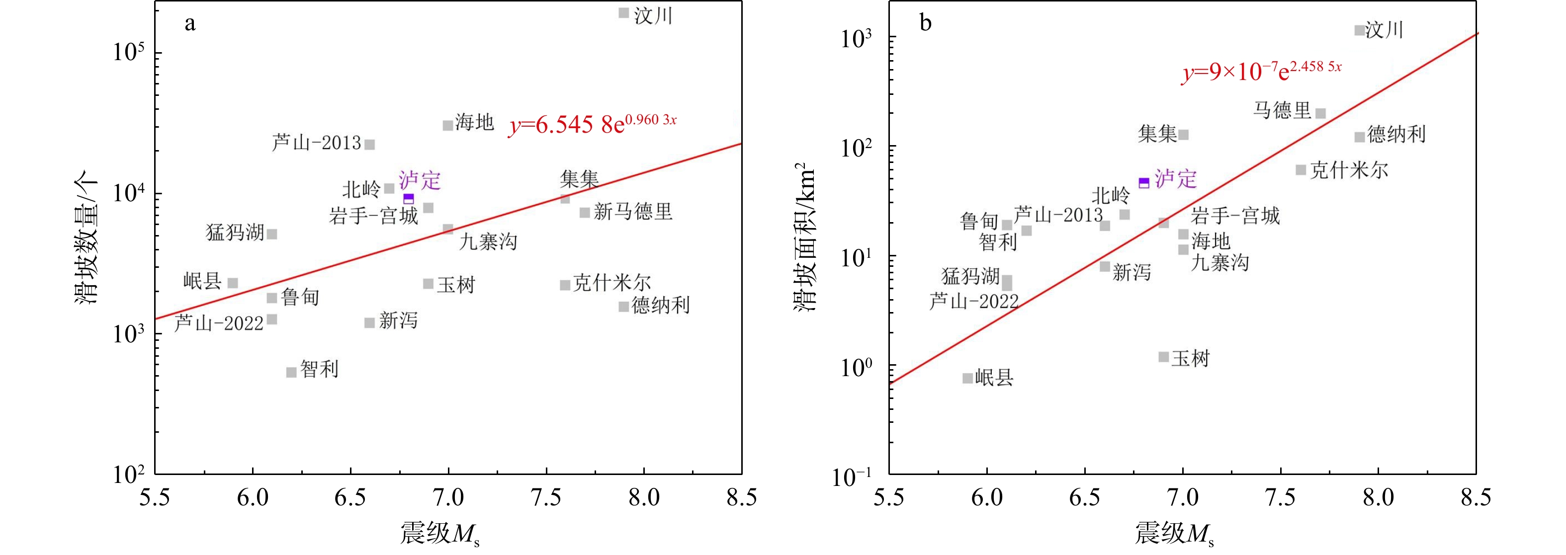
, Available online  , doi: 10.19509/j.cnki.dzkq.tb20240772
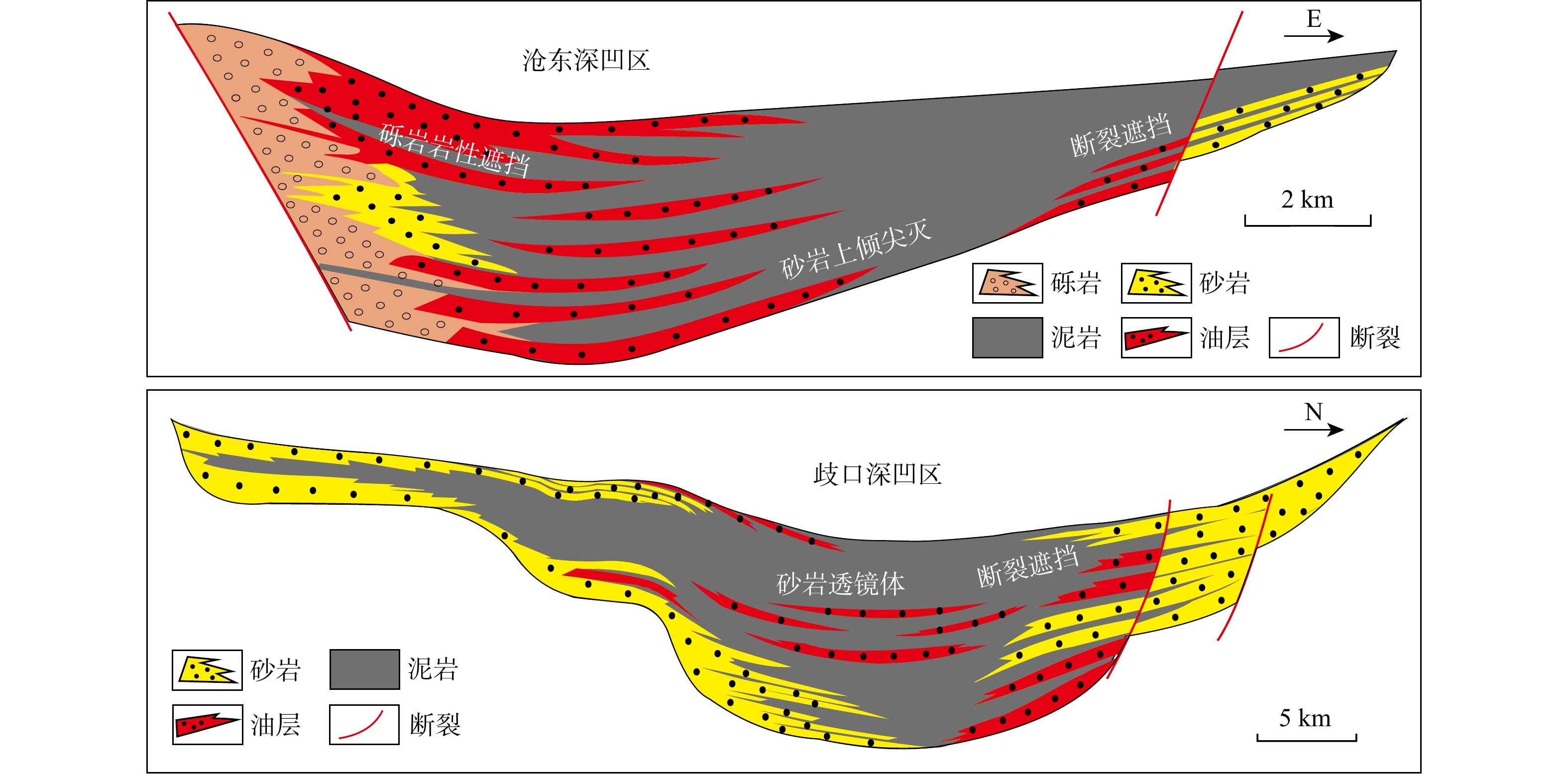
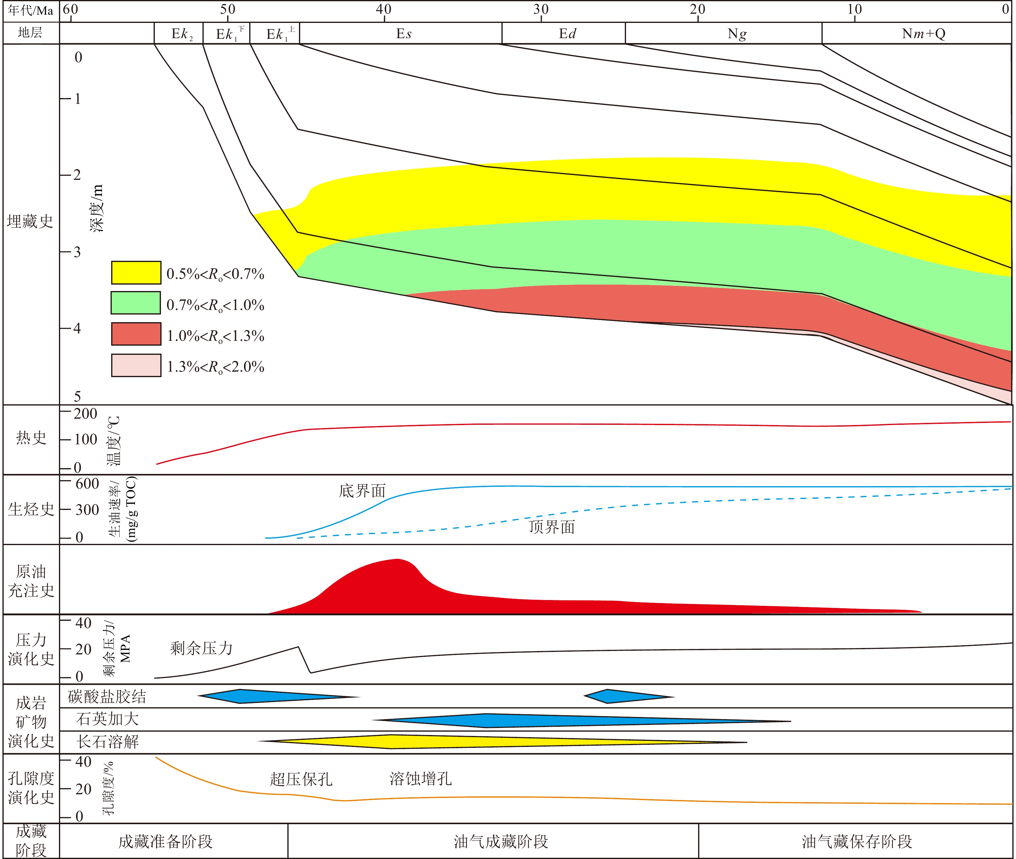
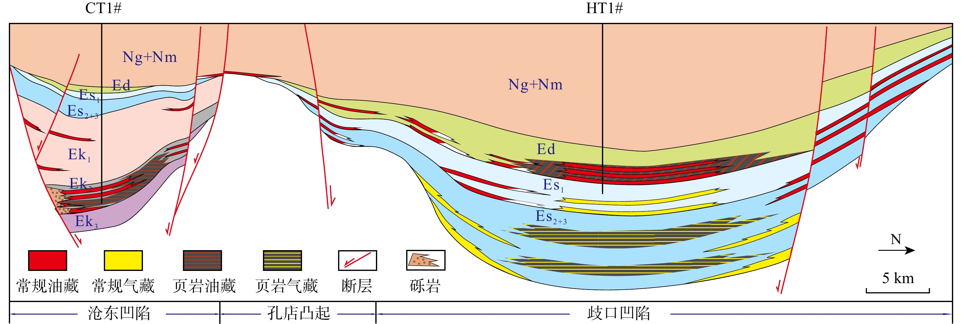
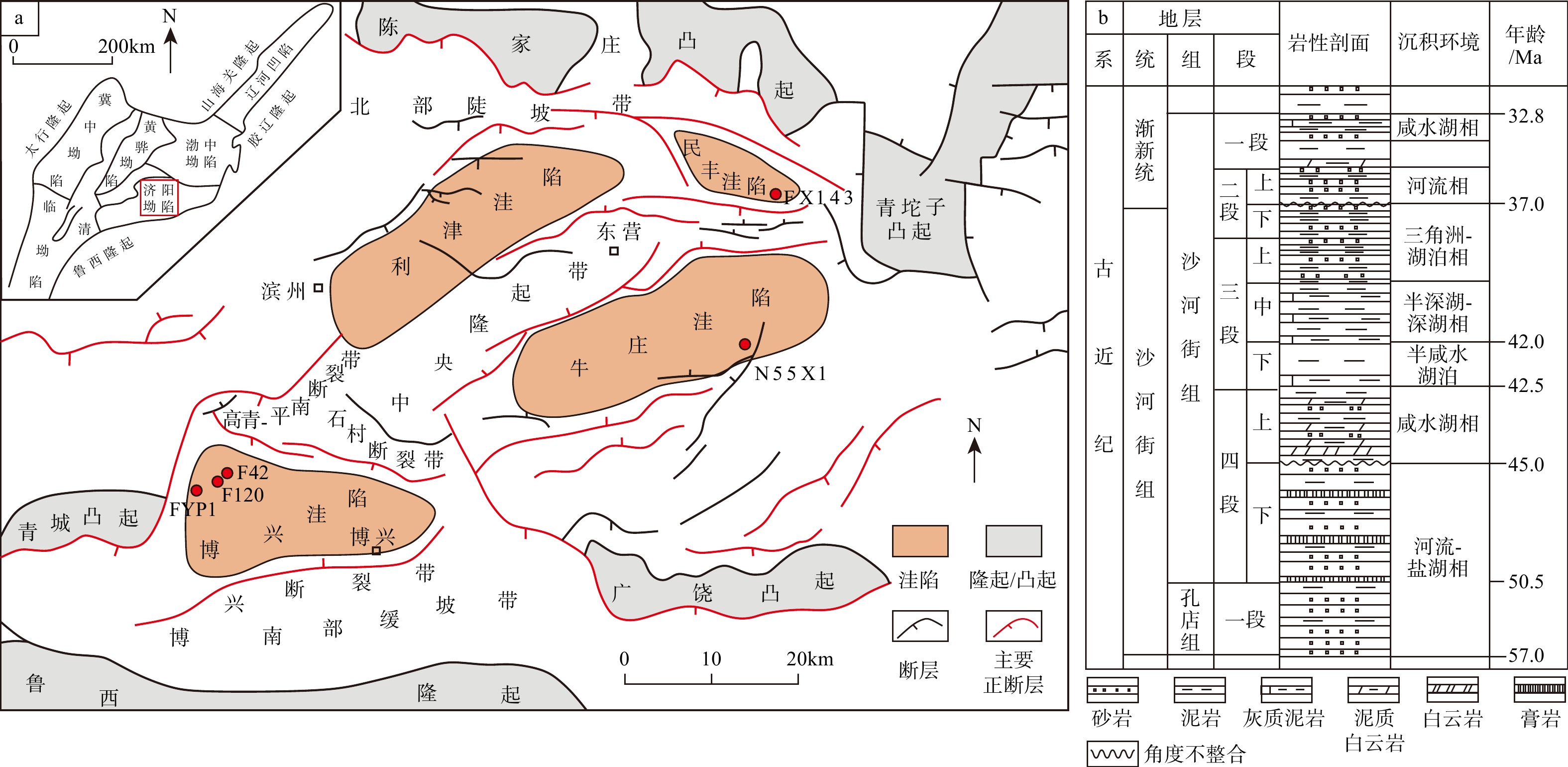
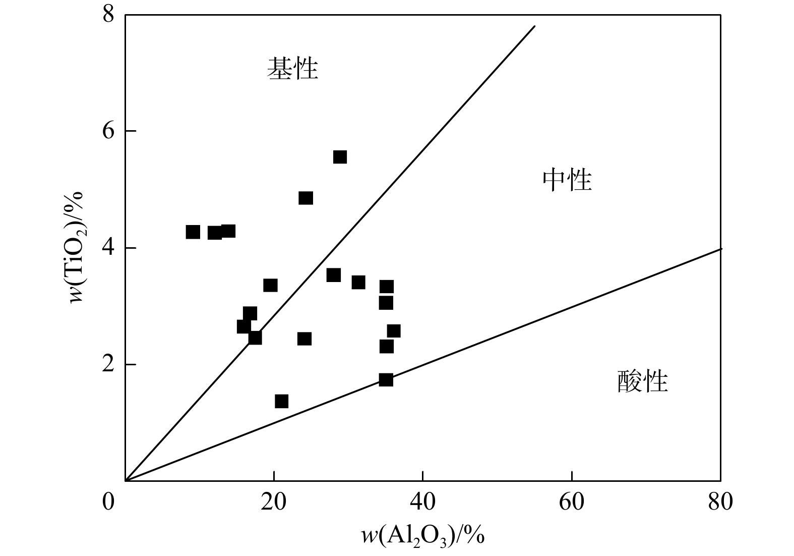
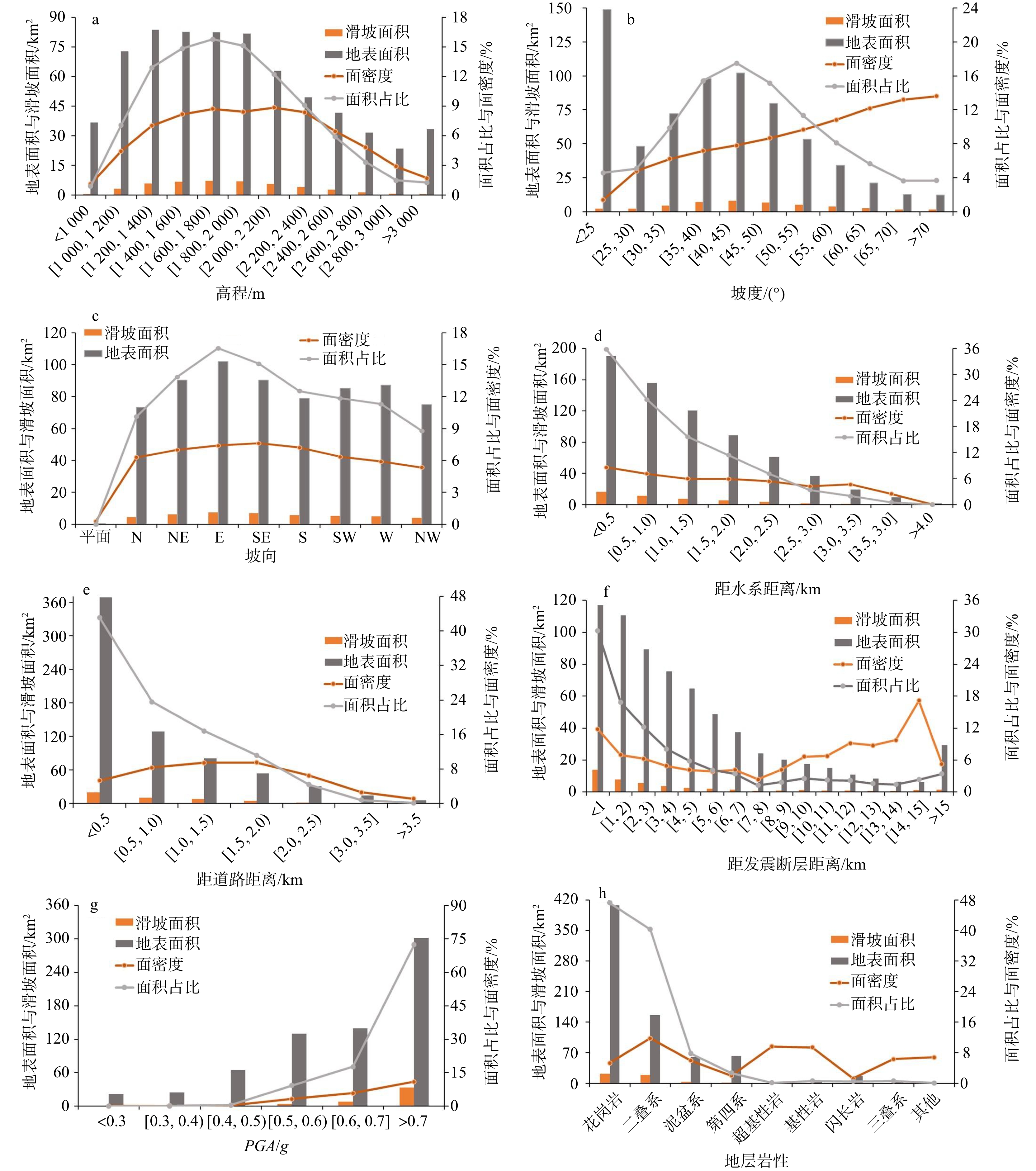
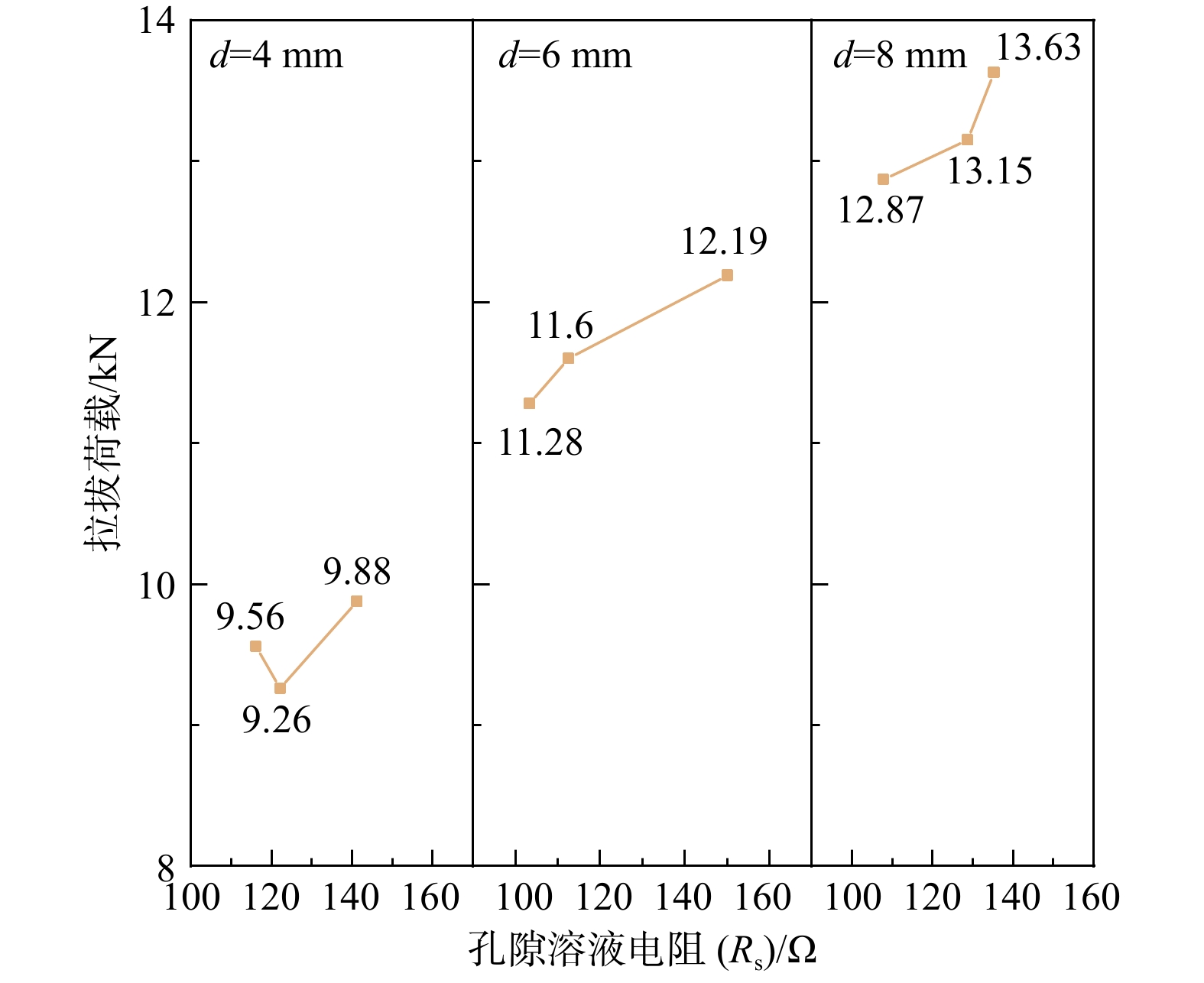
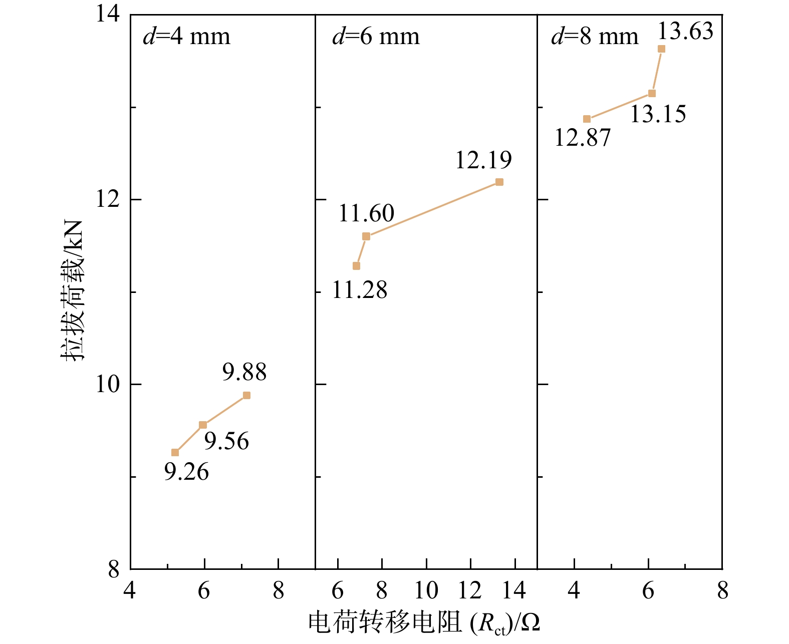
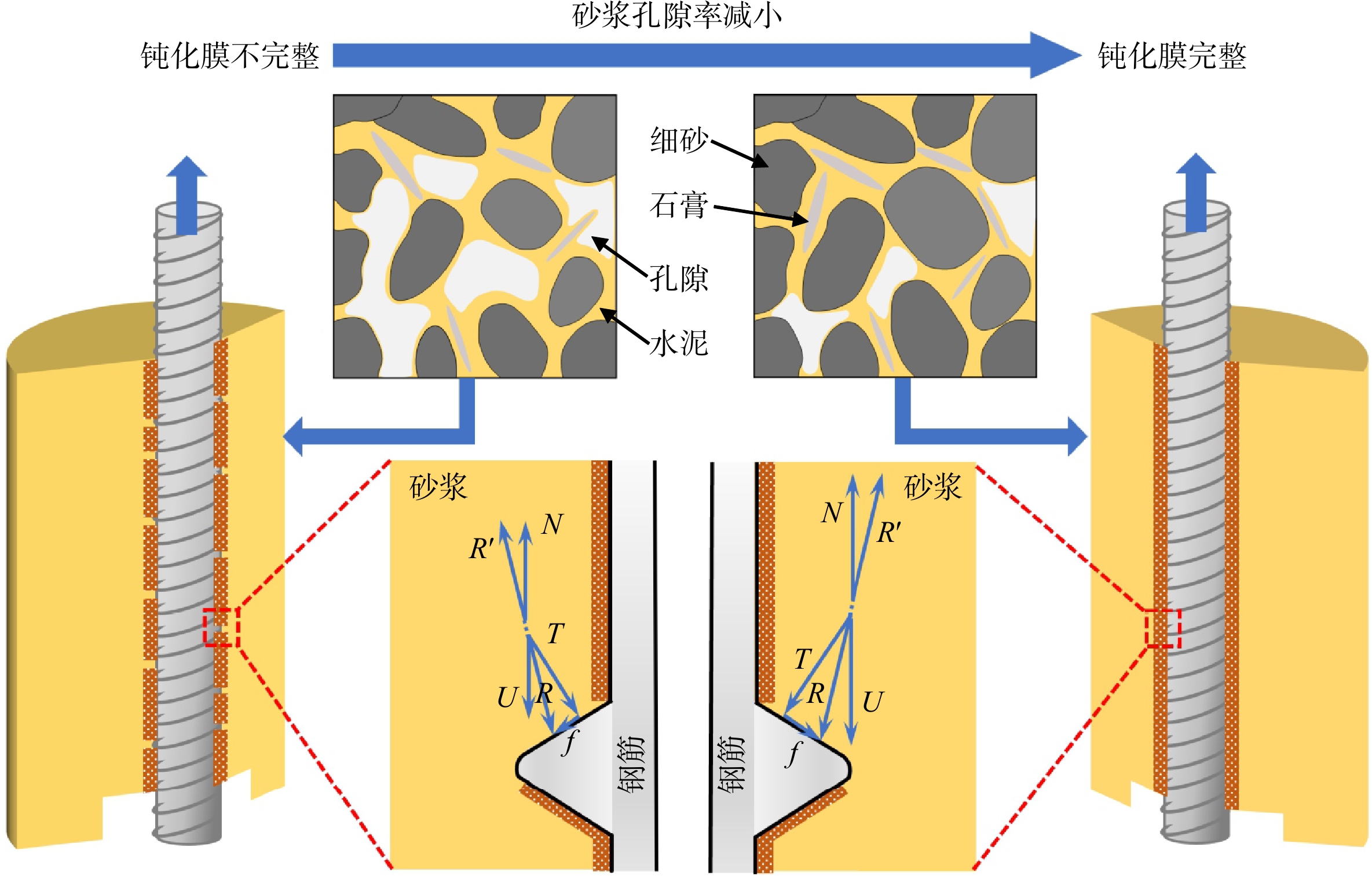
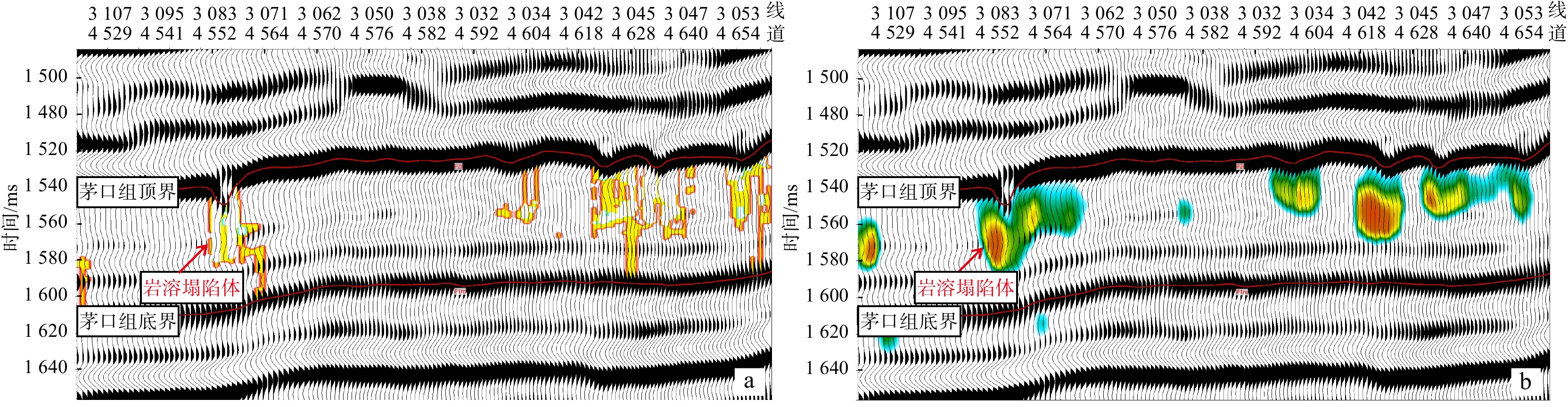
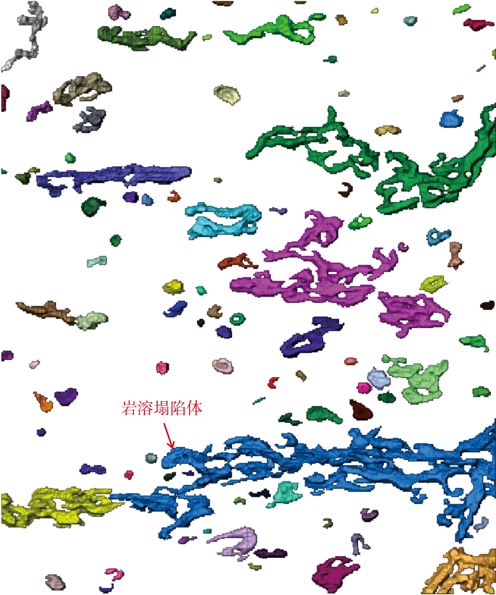
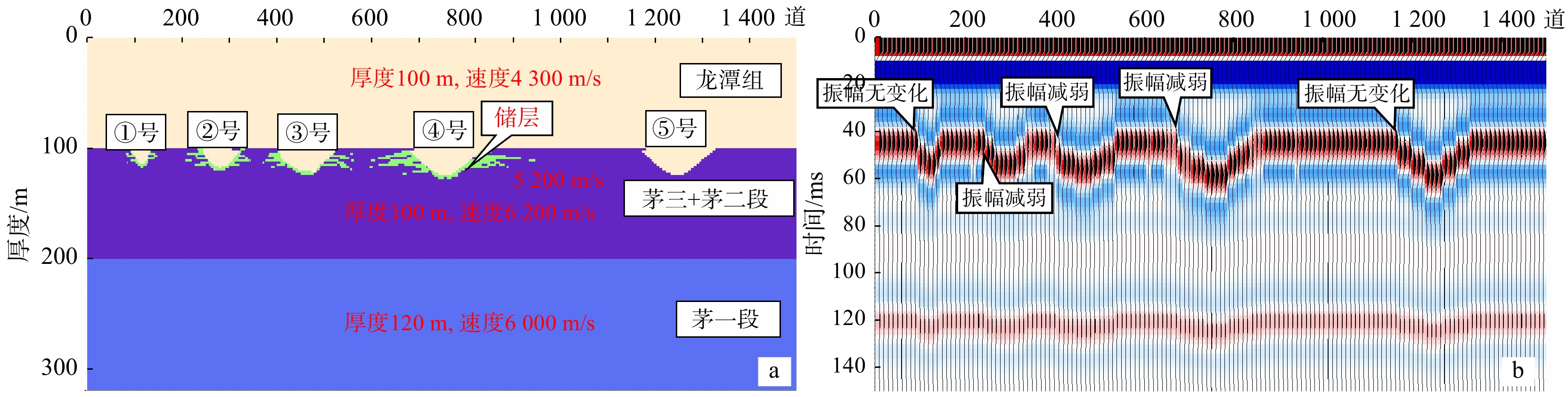
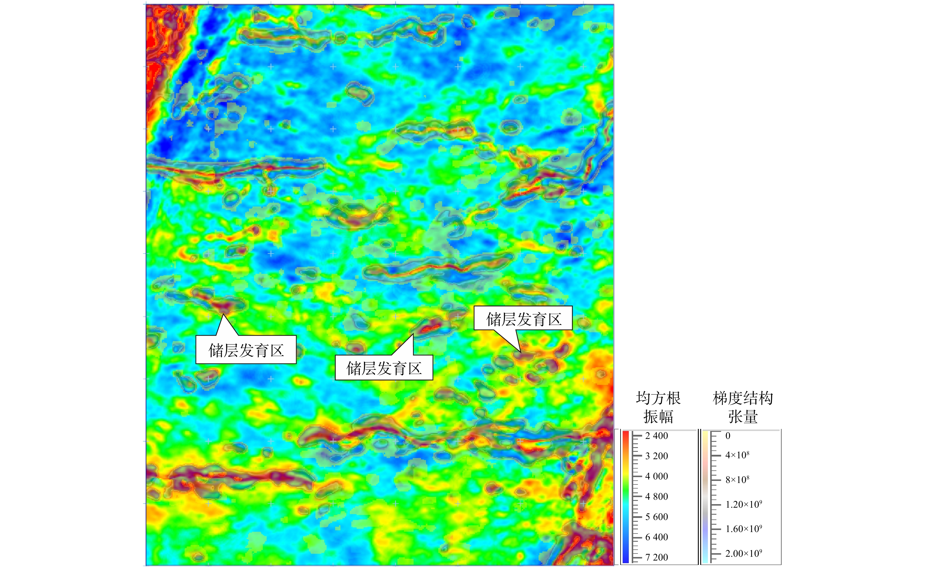
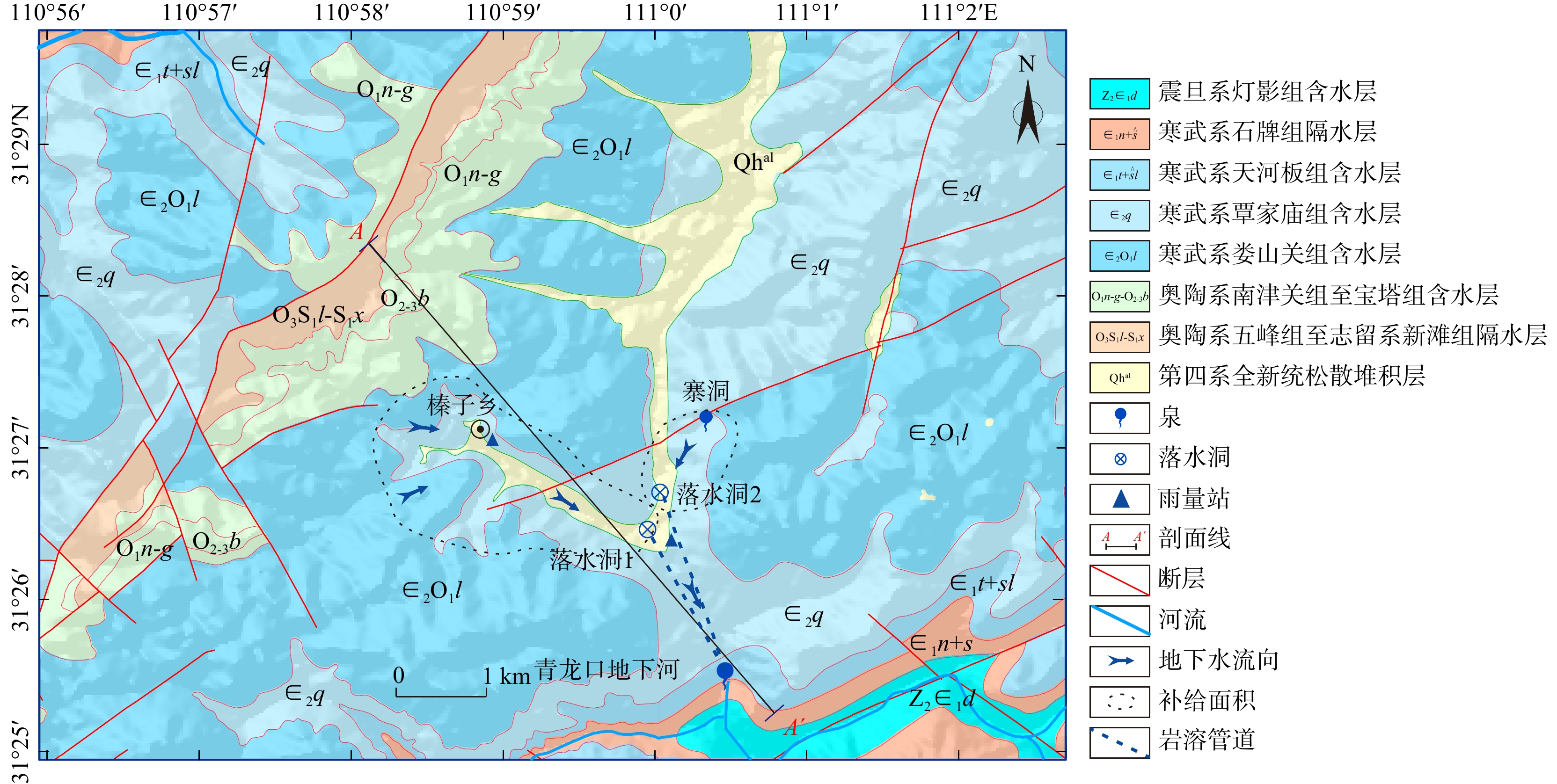
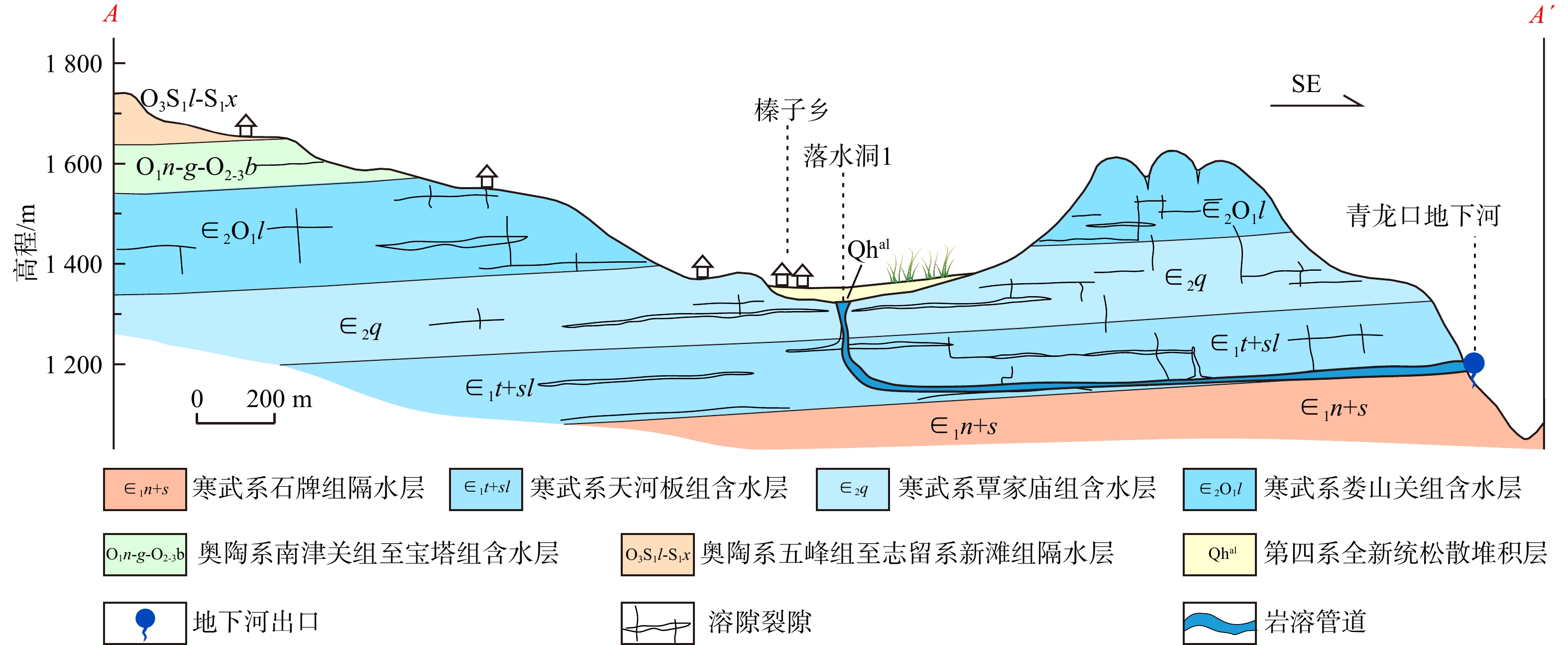
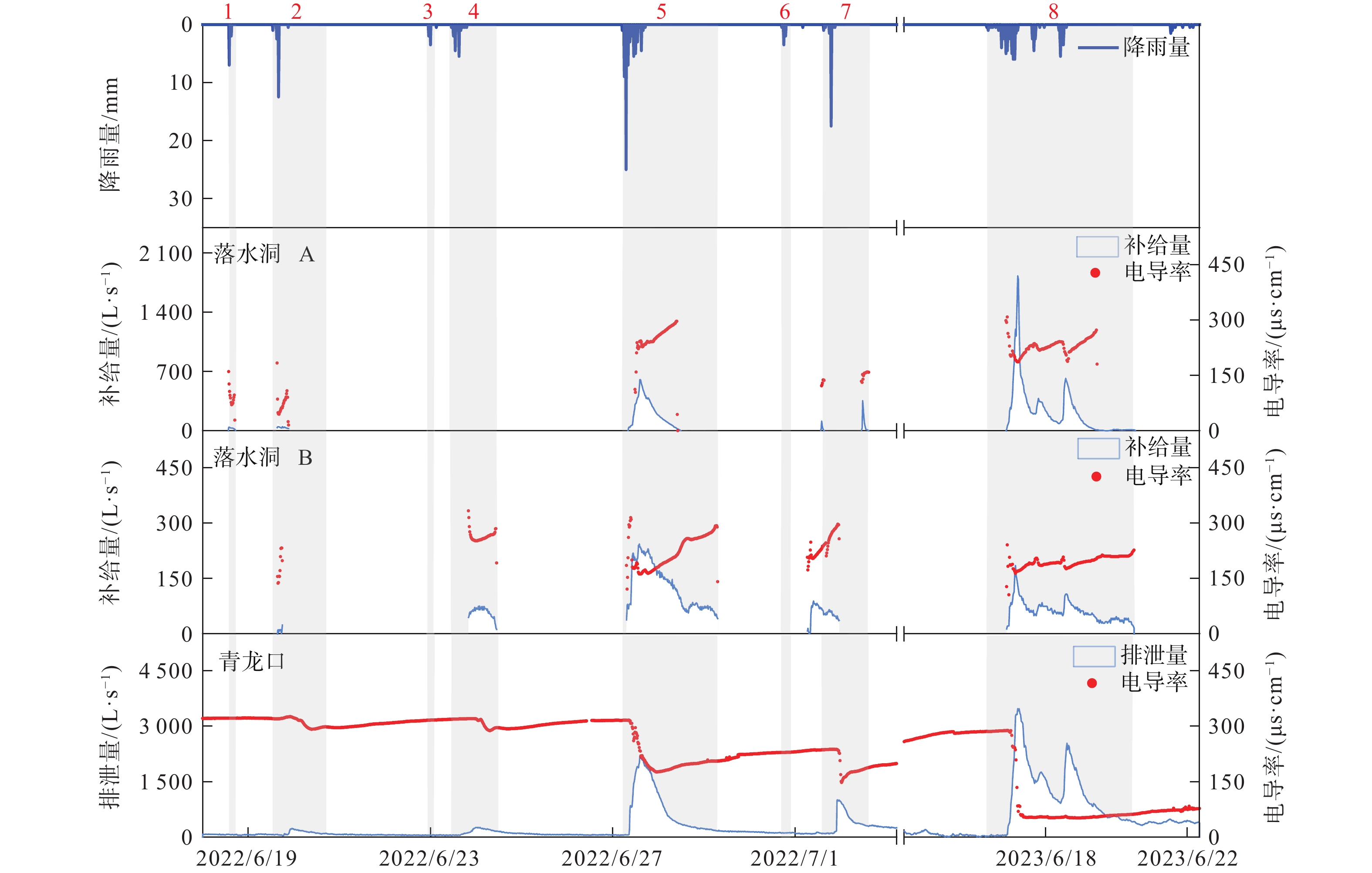
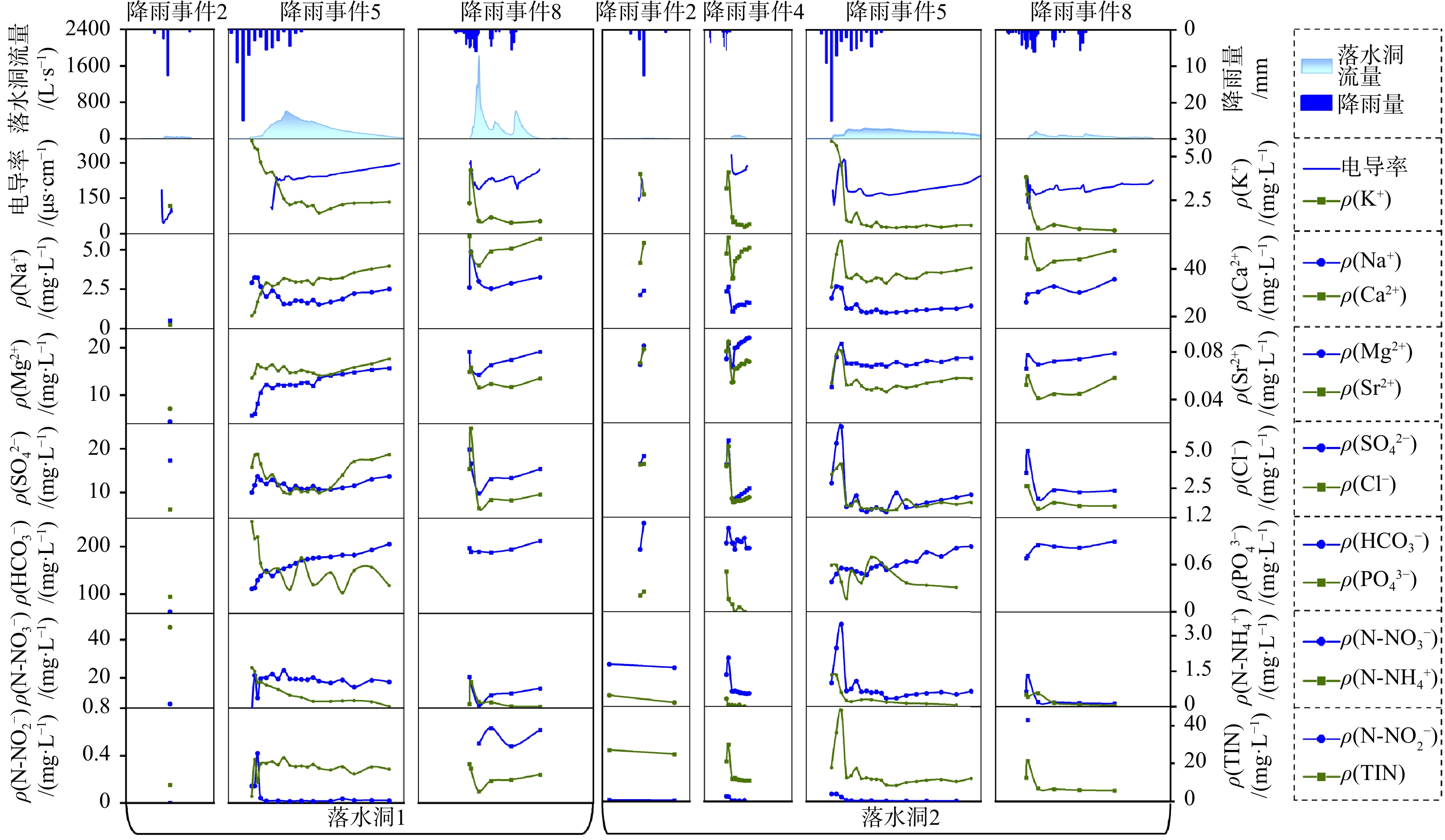
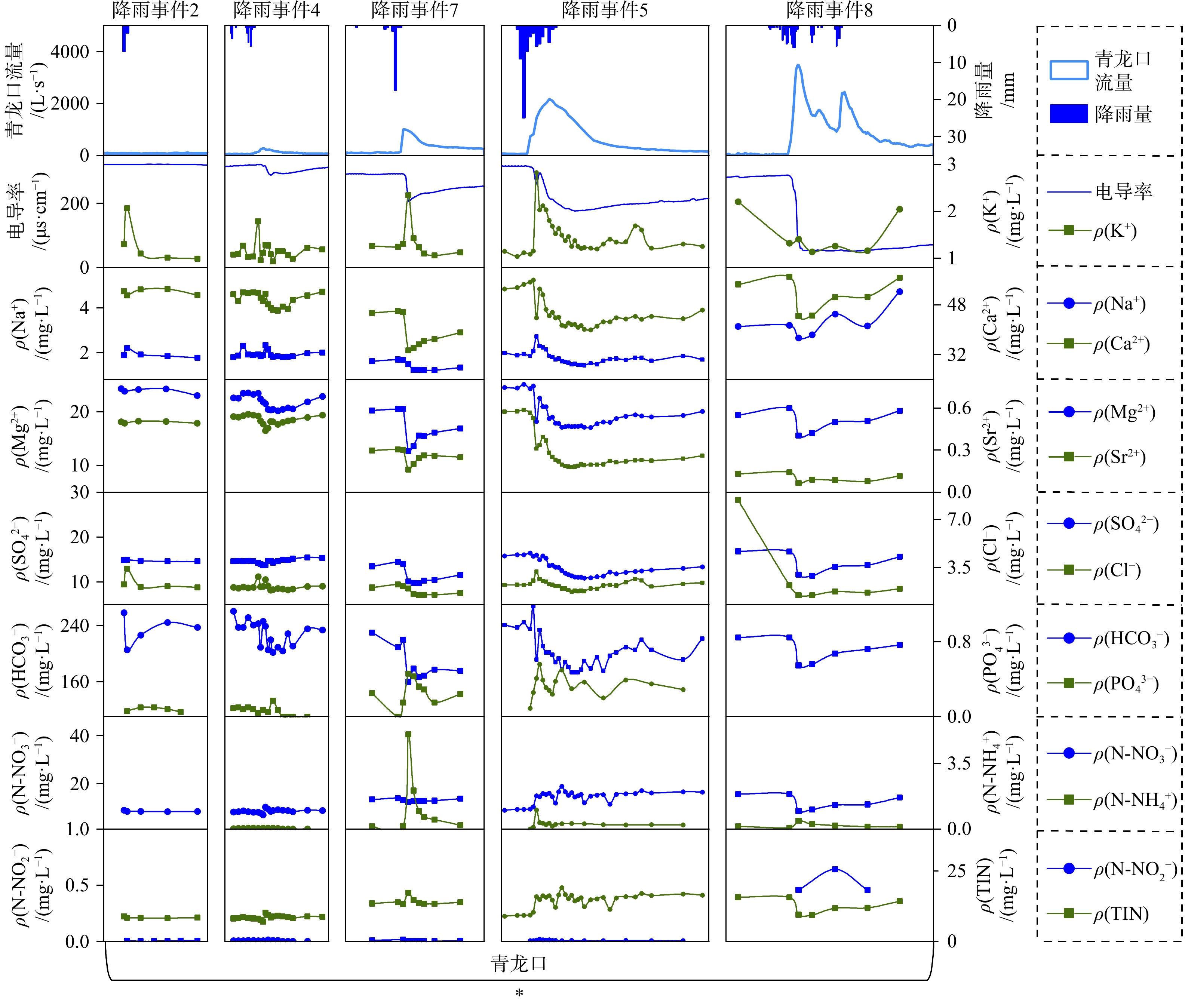
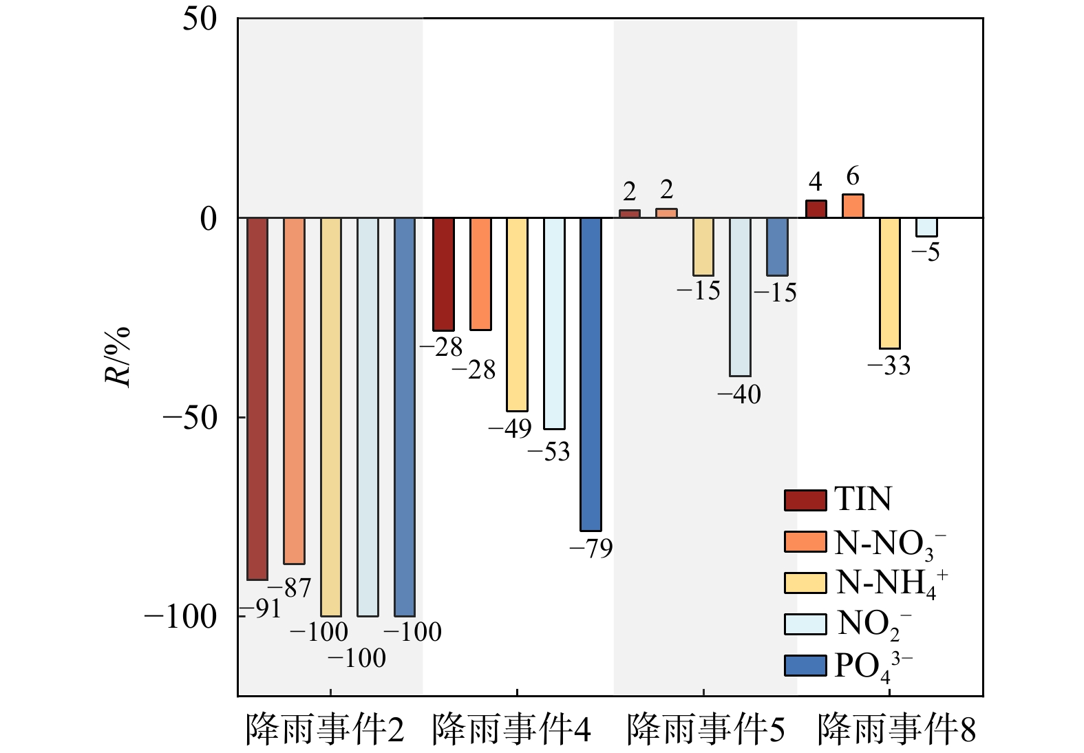
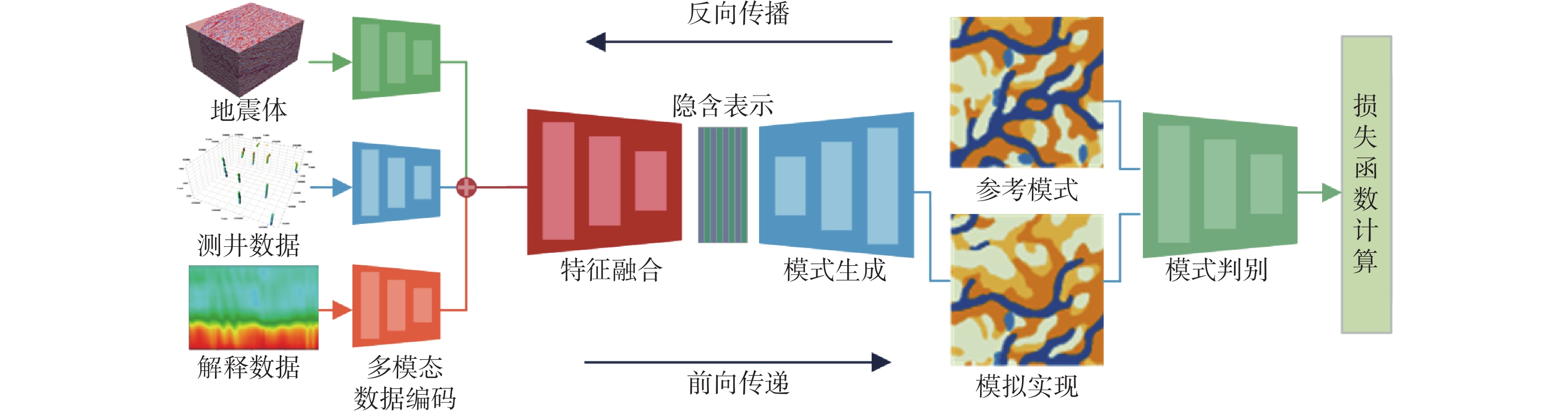
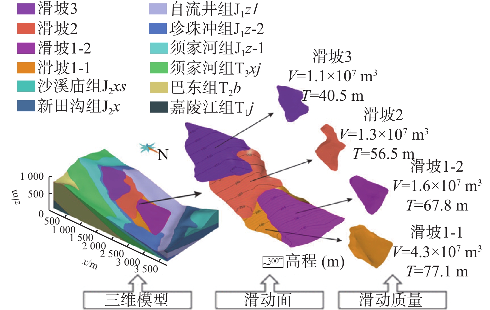
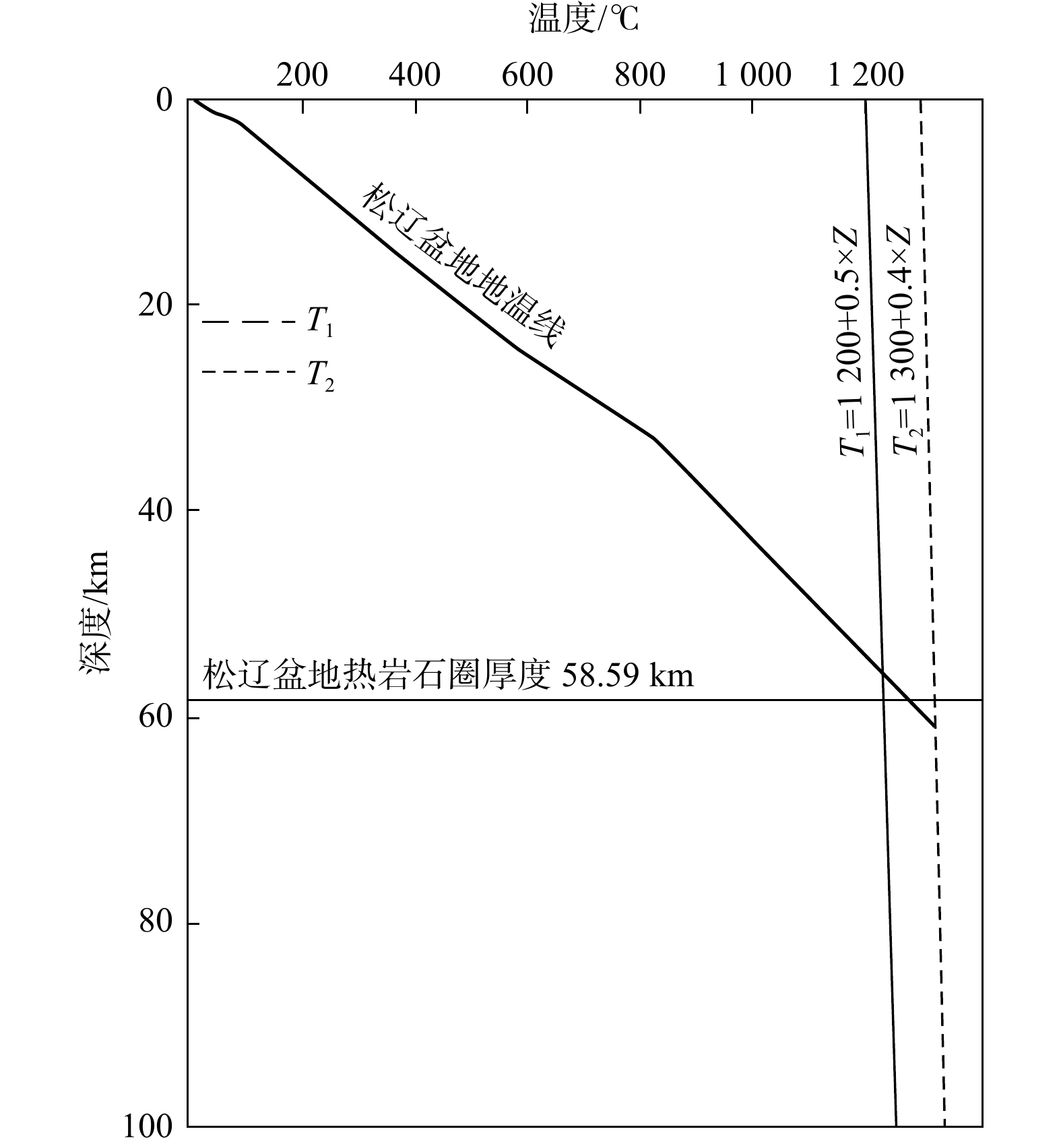
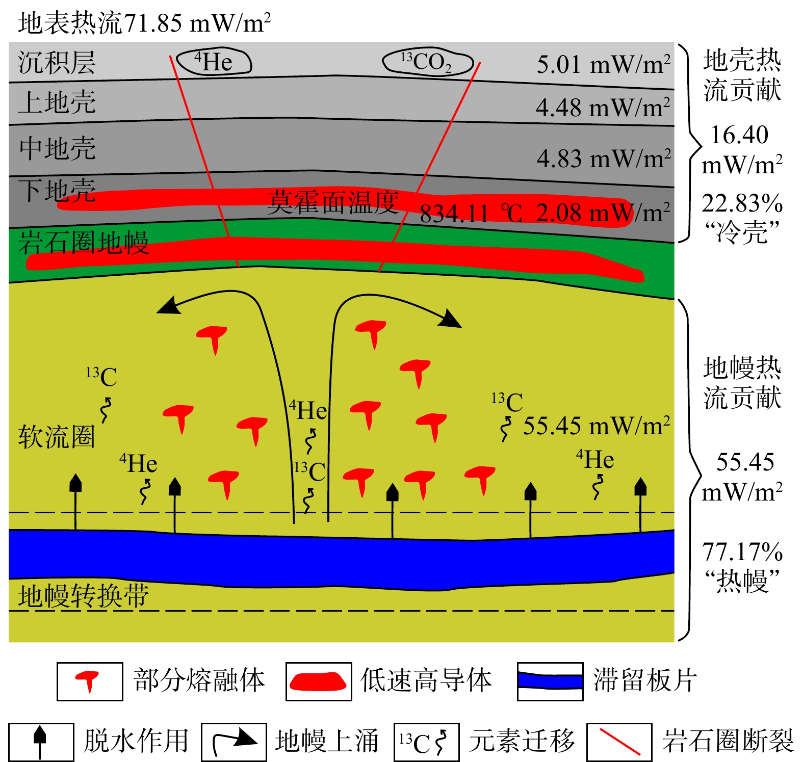
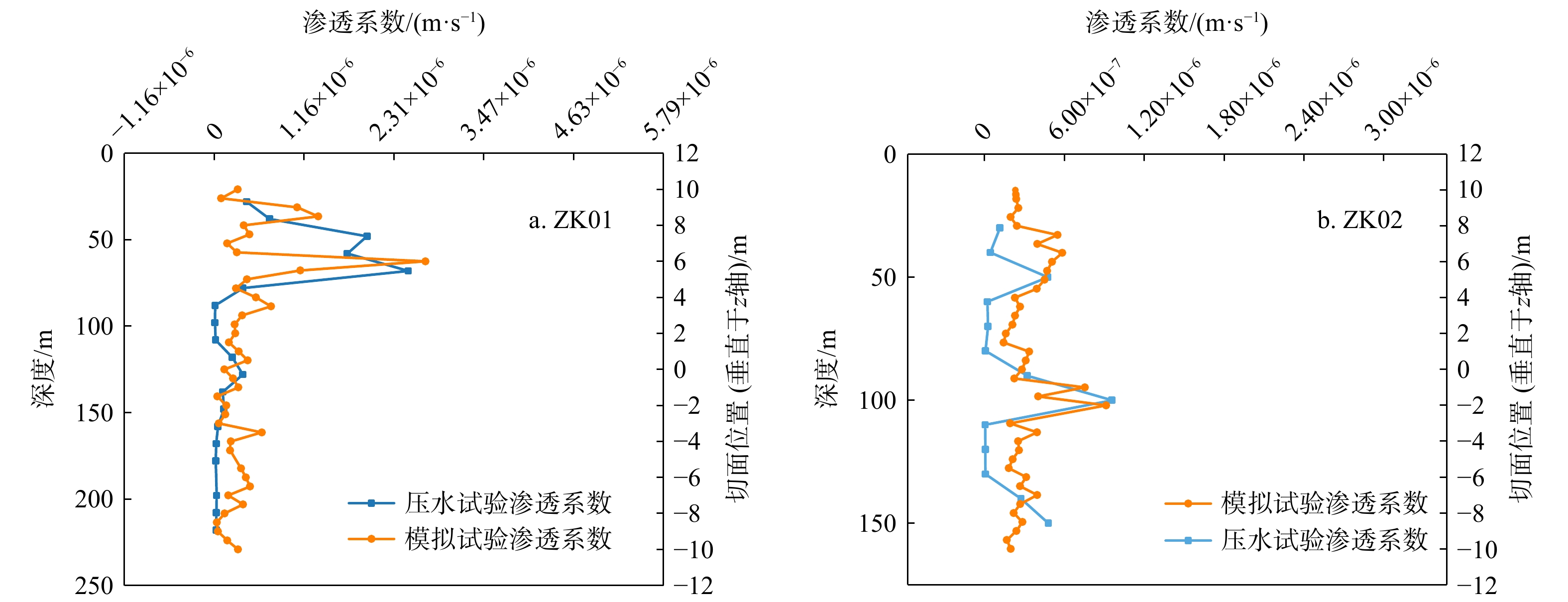
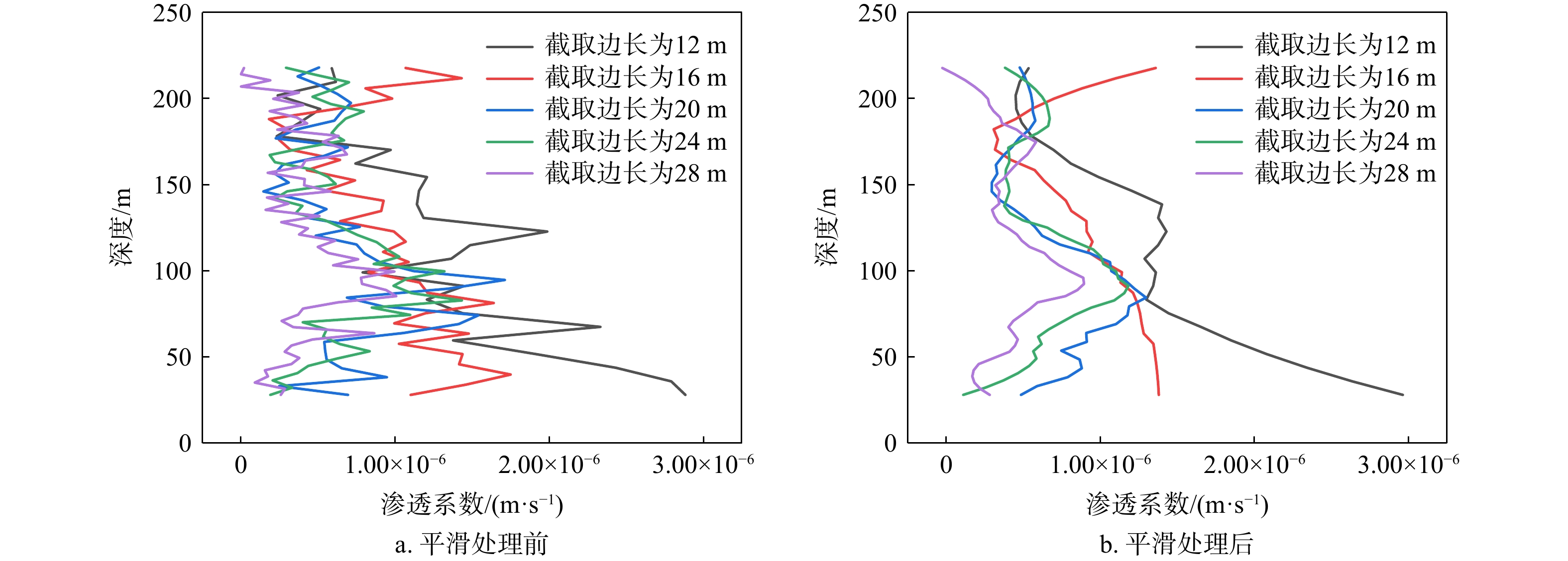
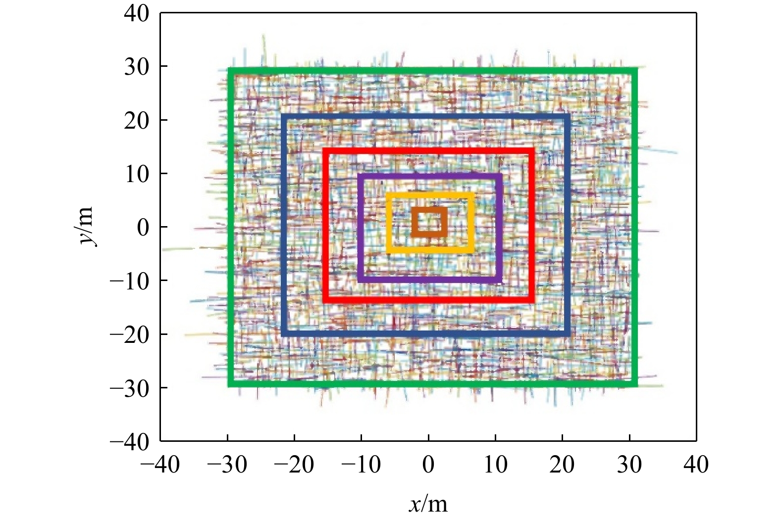
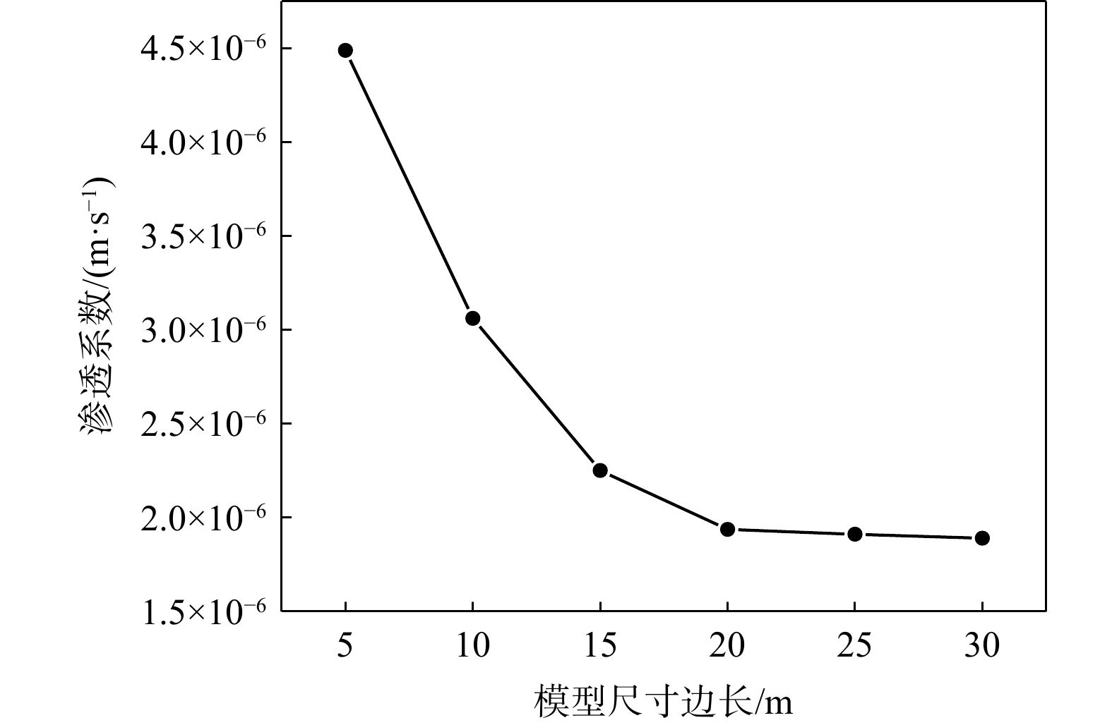
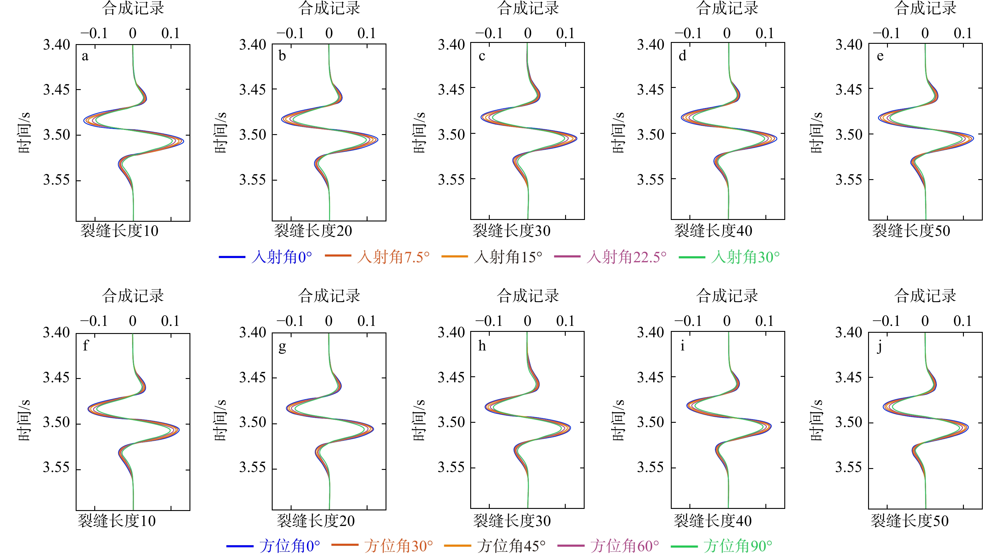
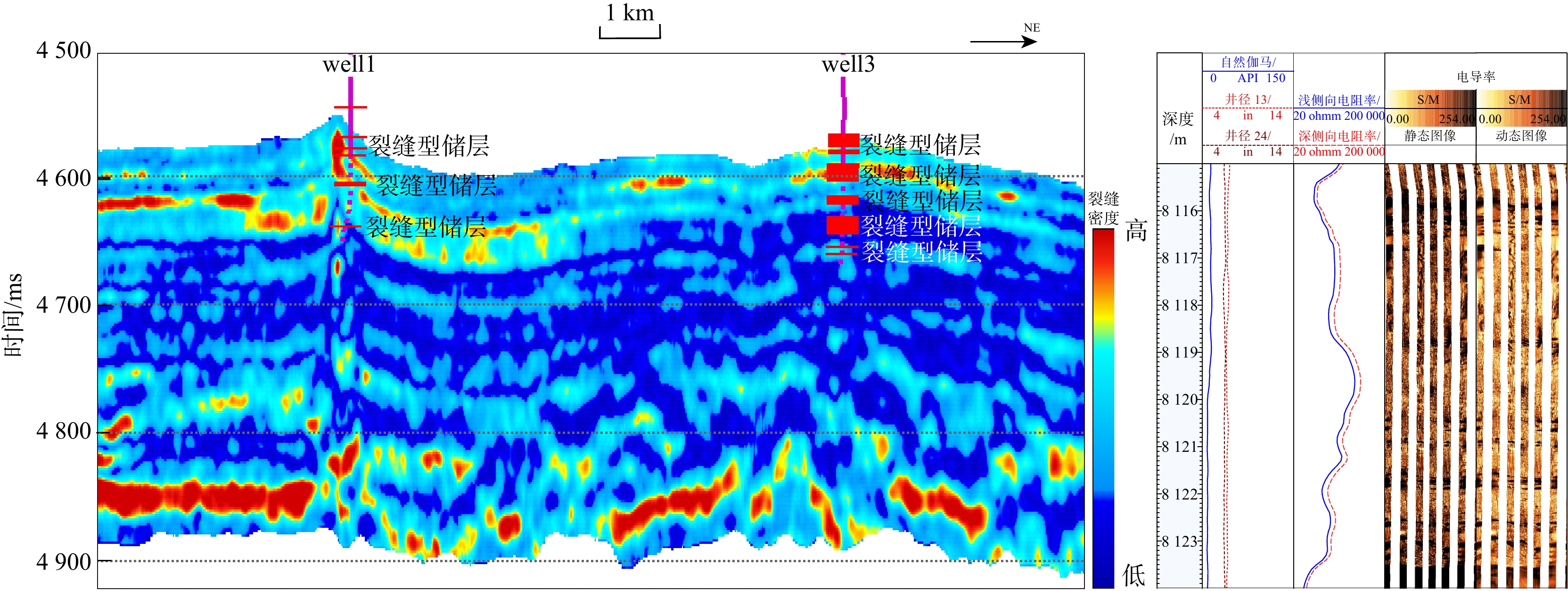
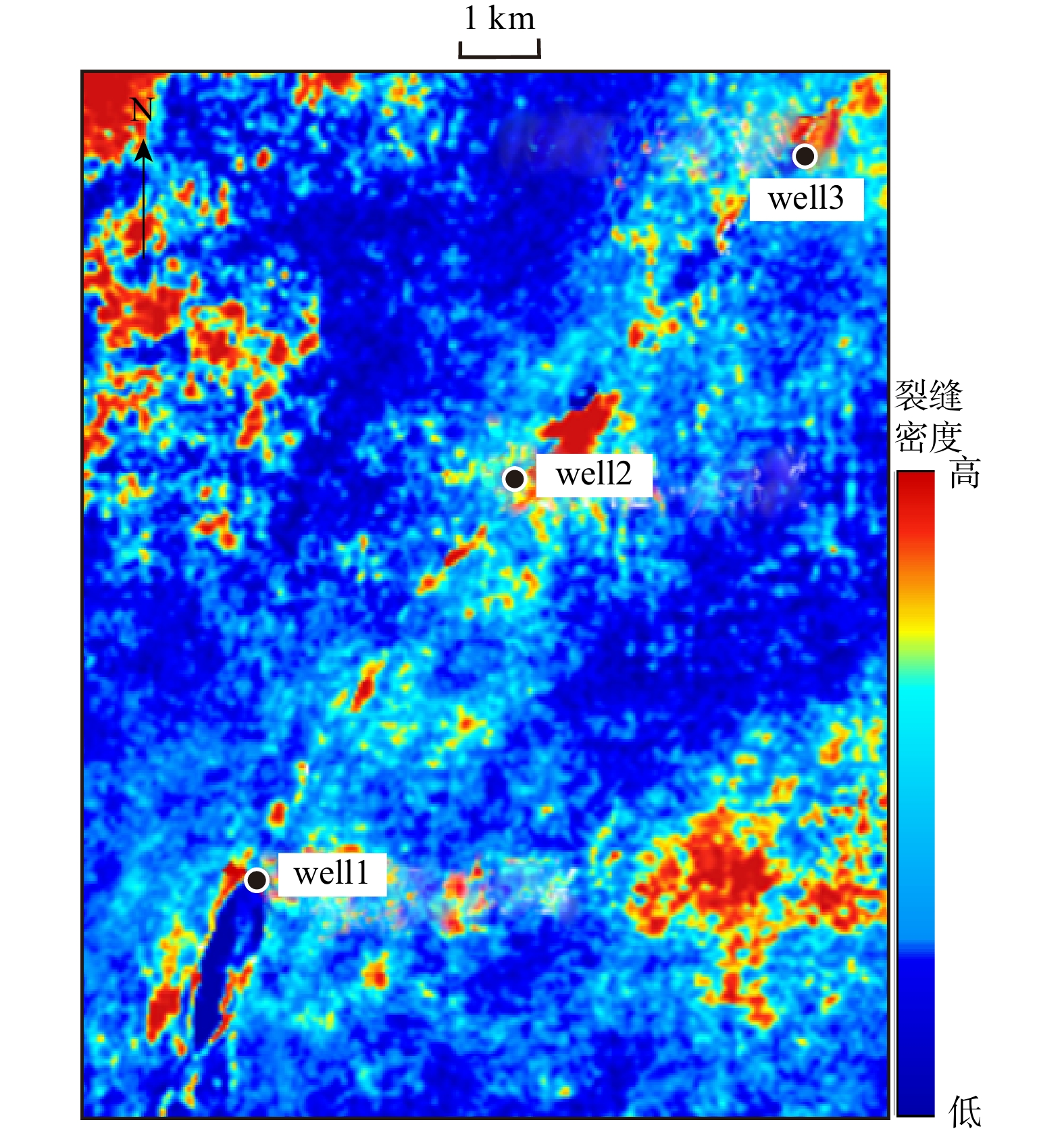
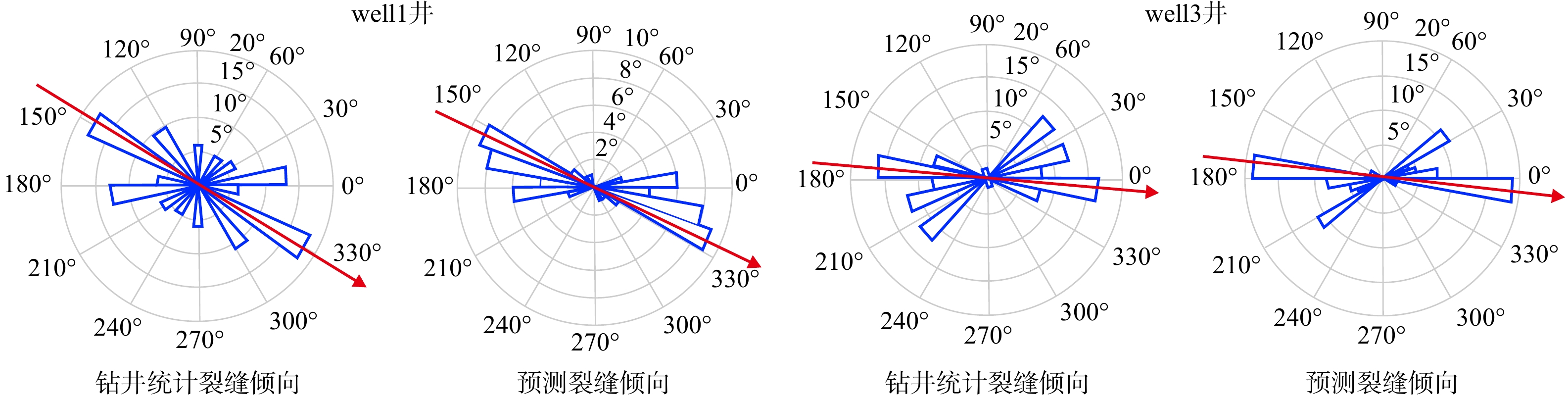
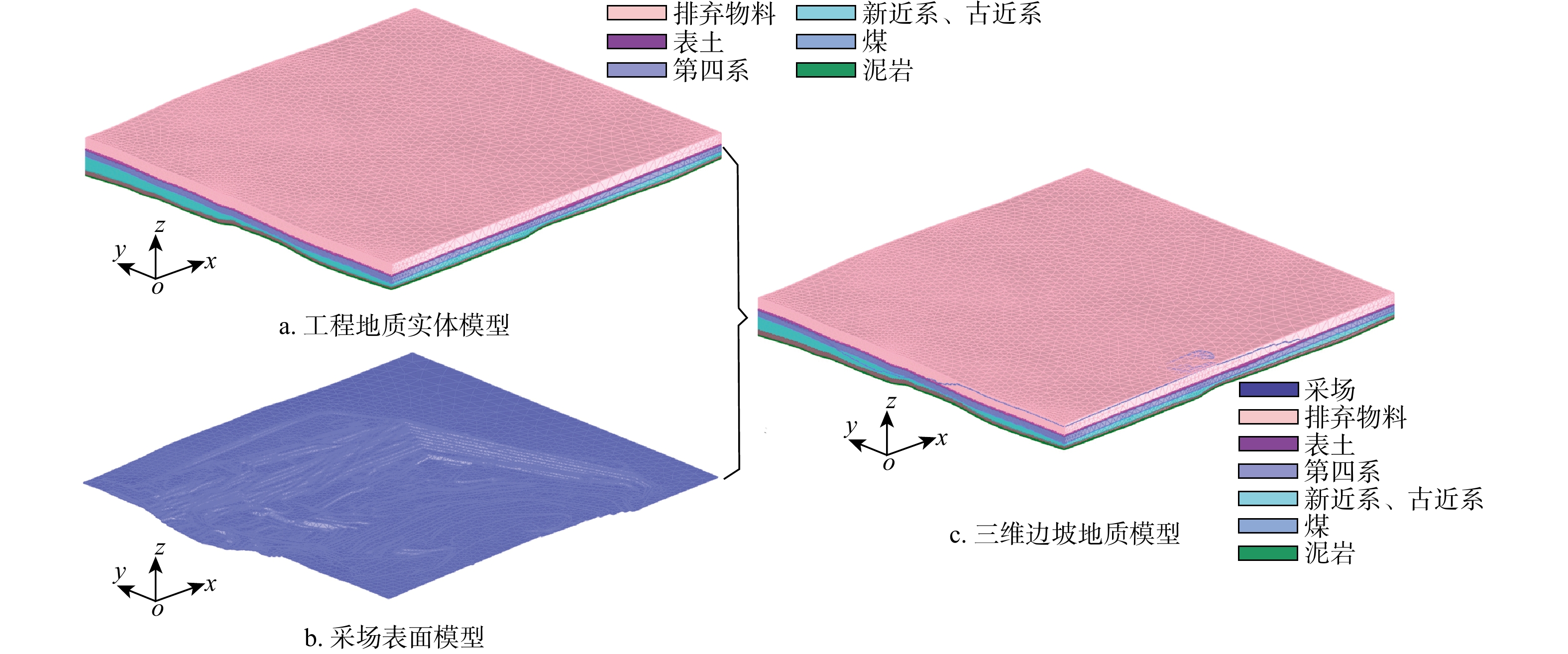
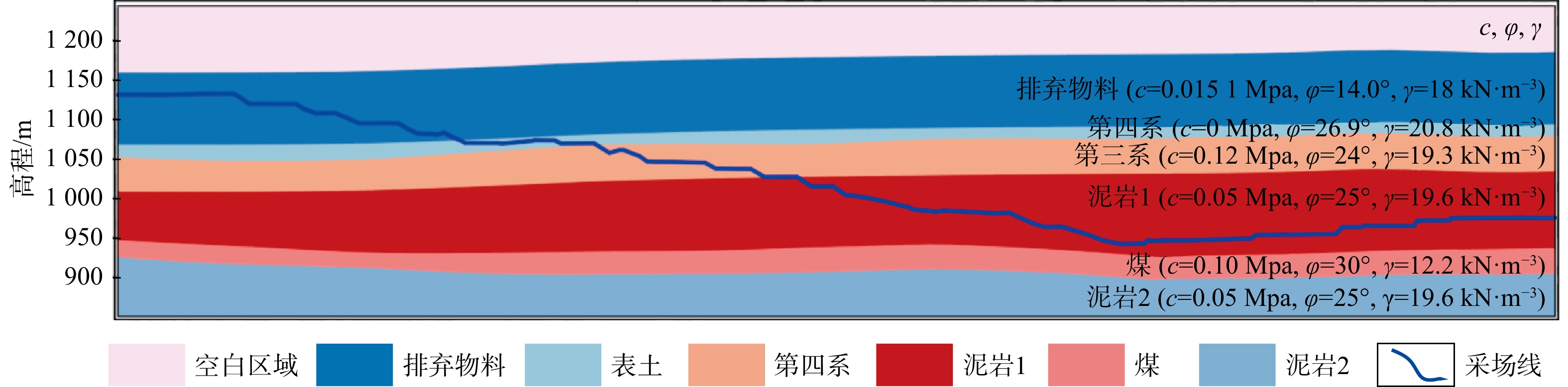
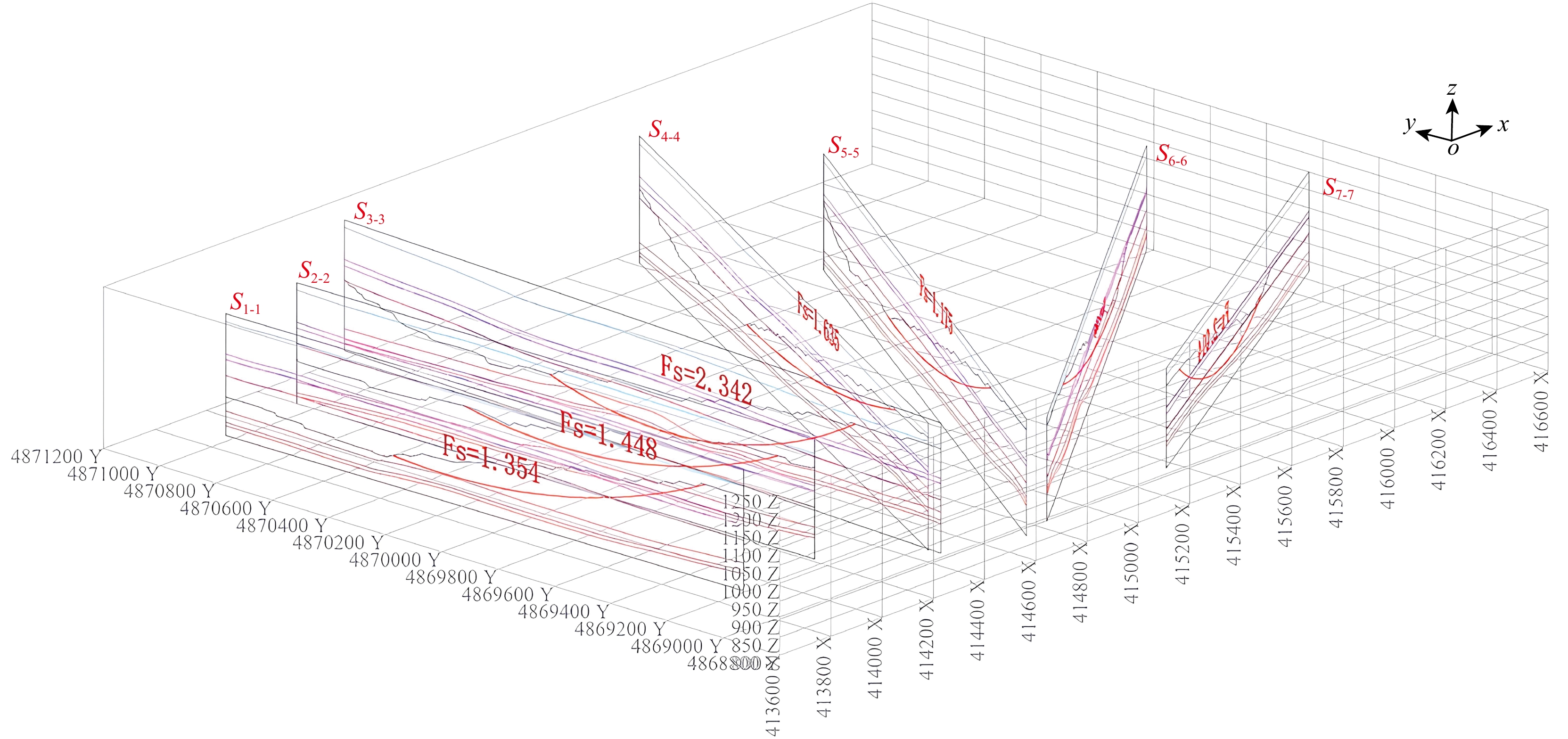
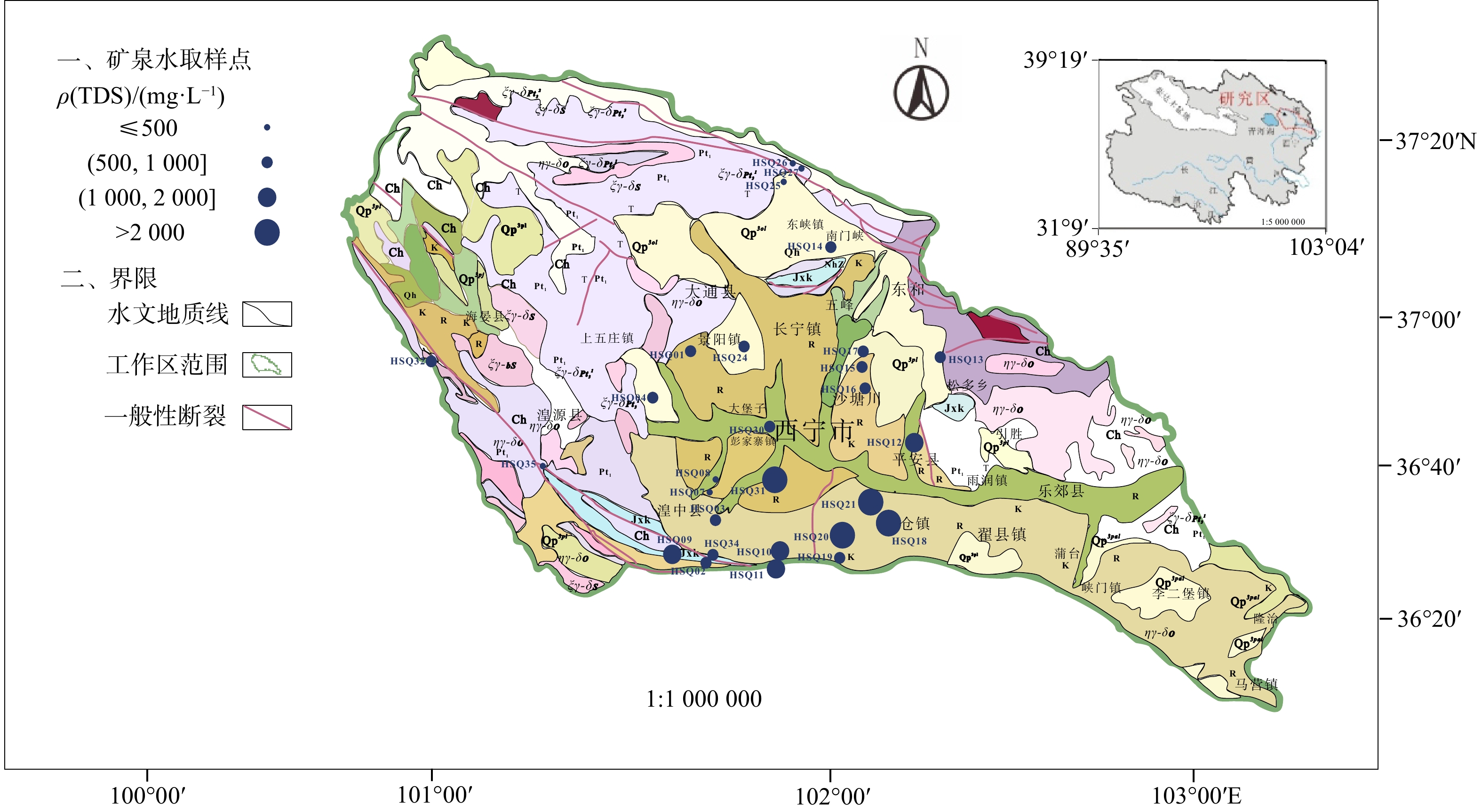
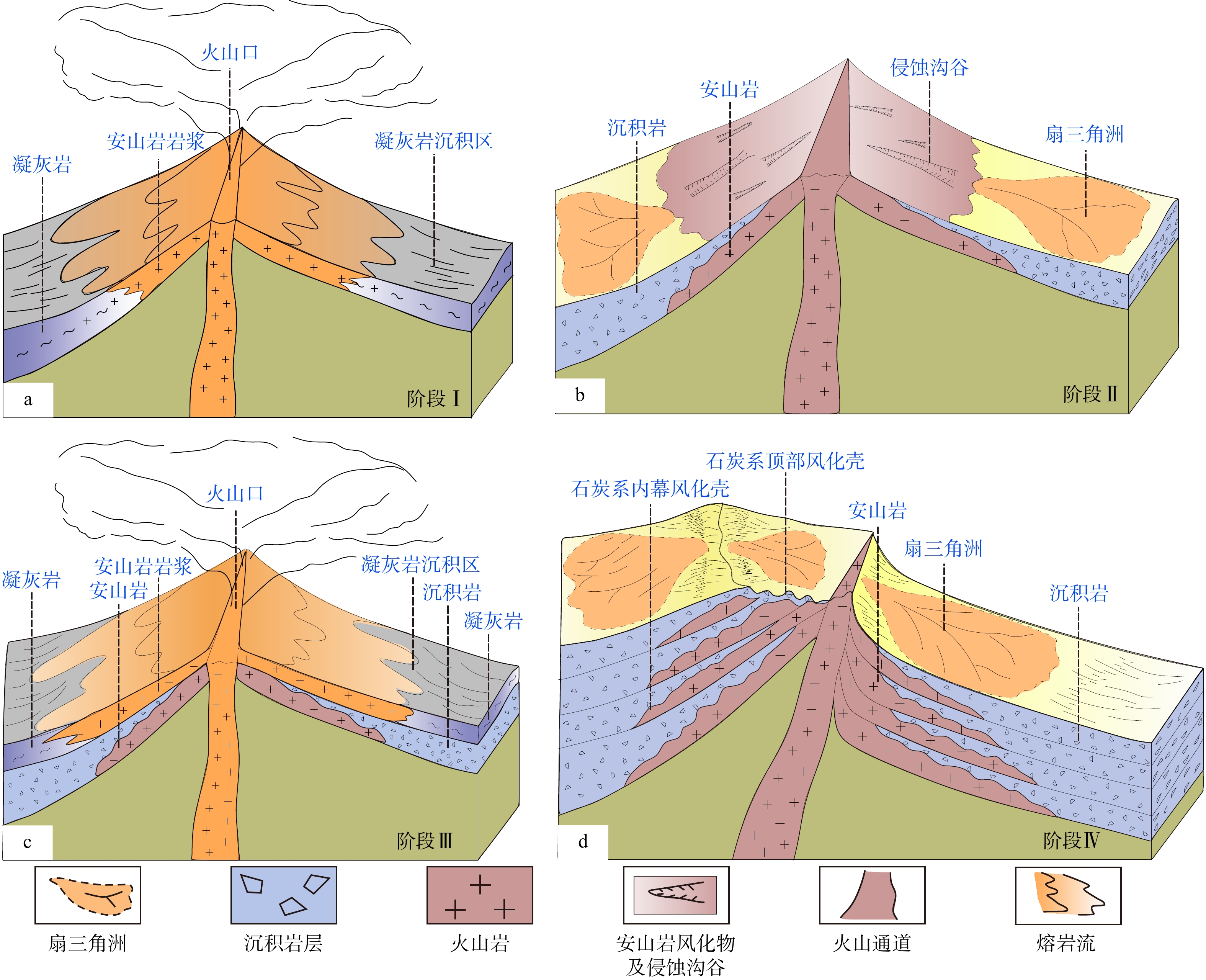
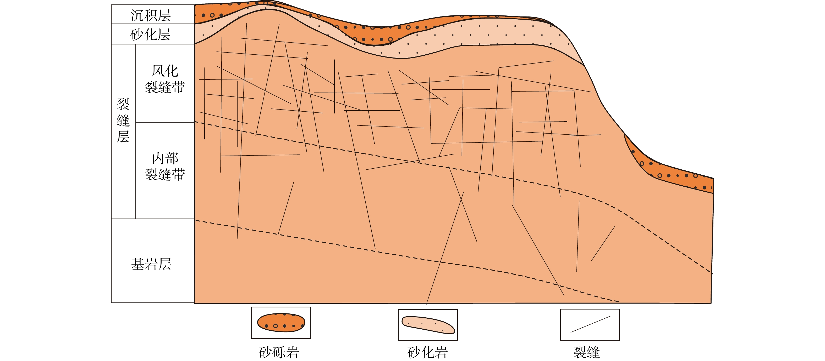
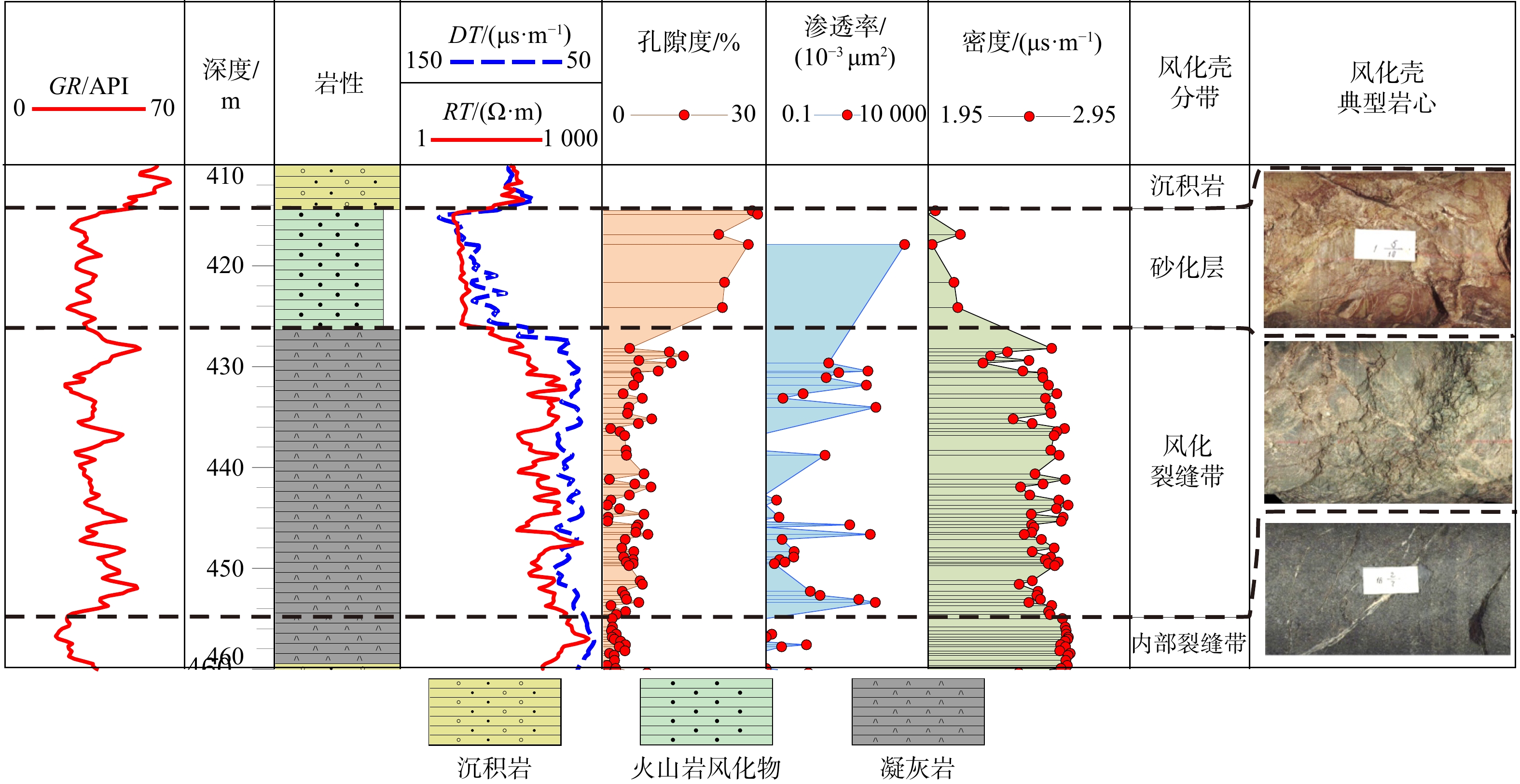
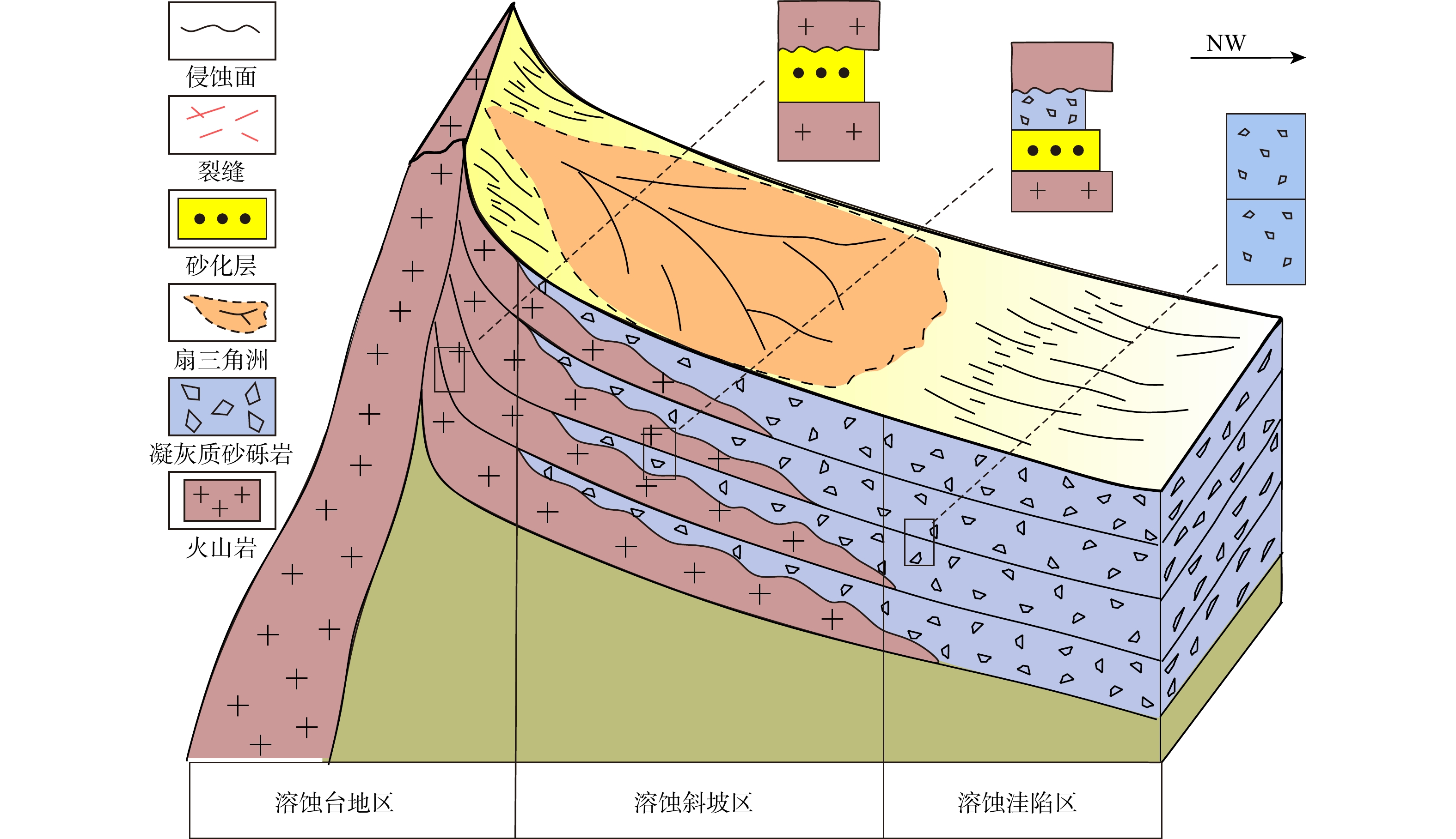
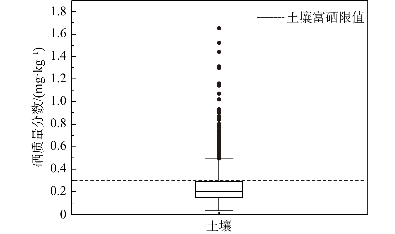
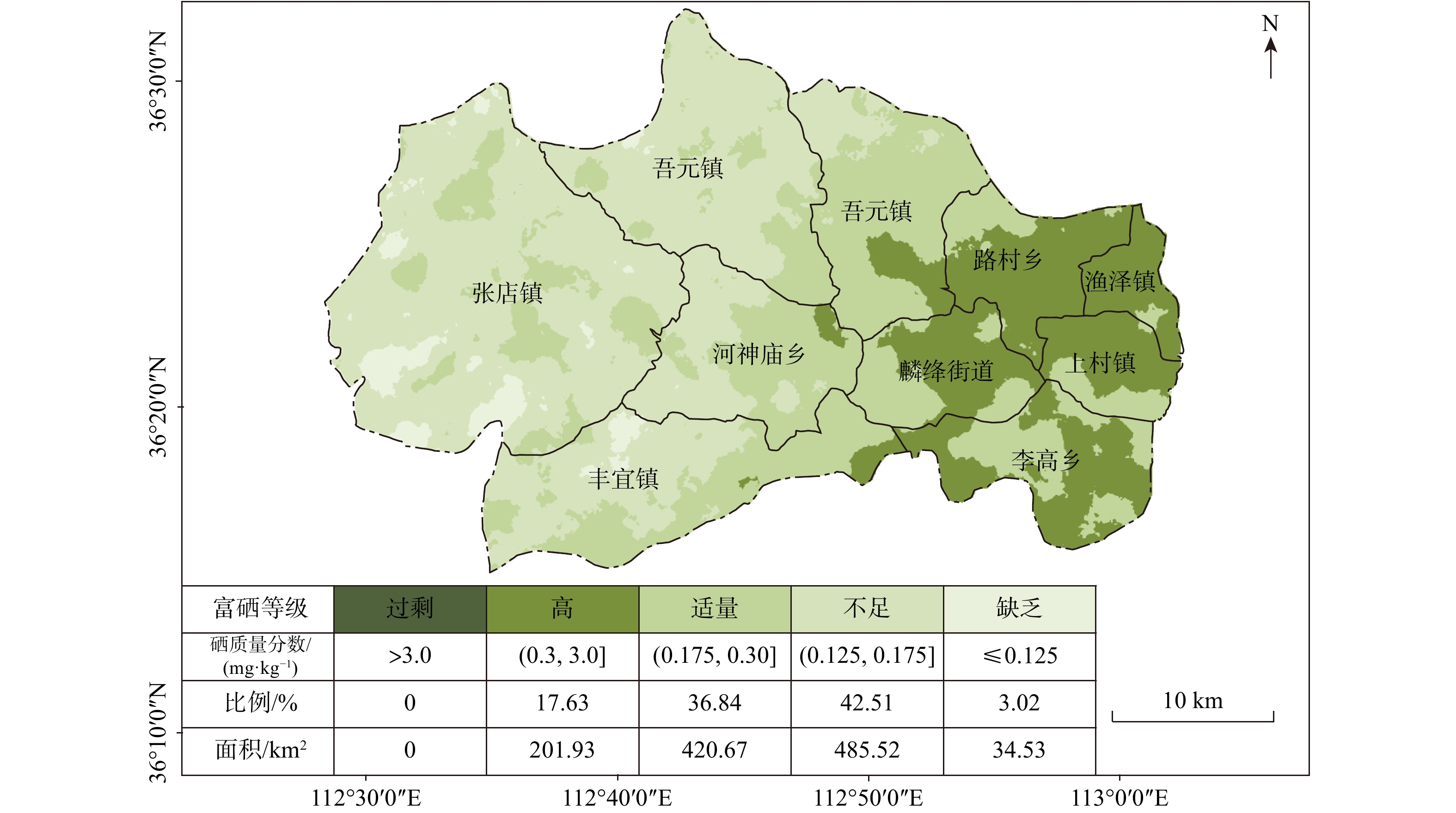
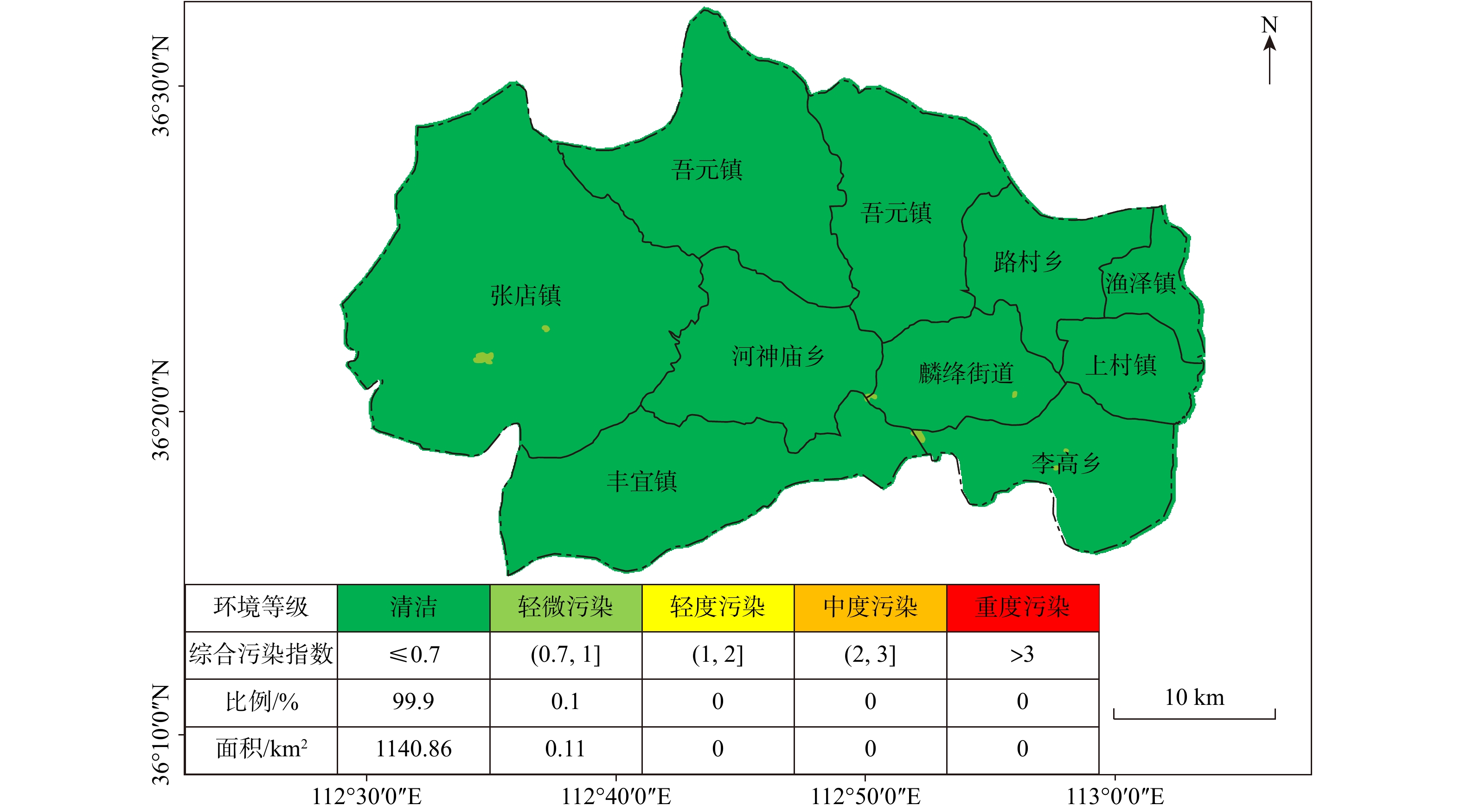
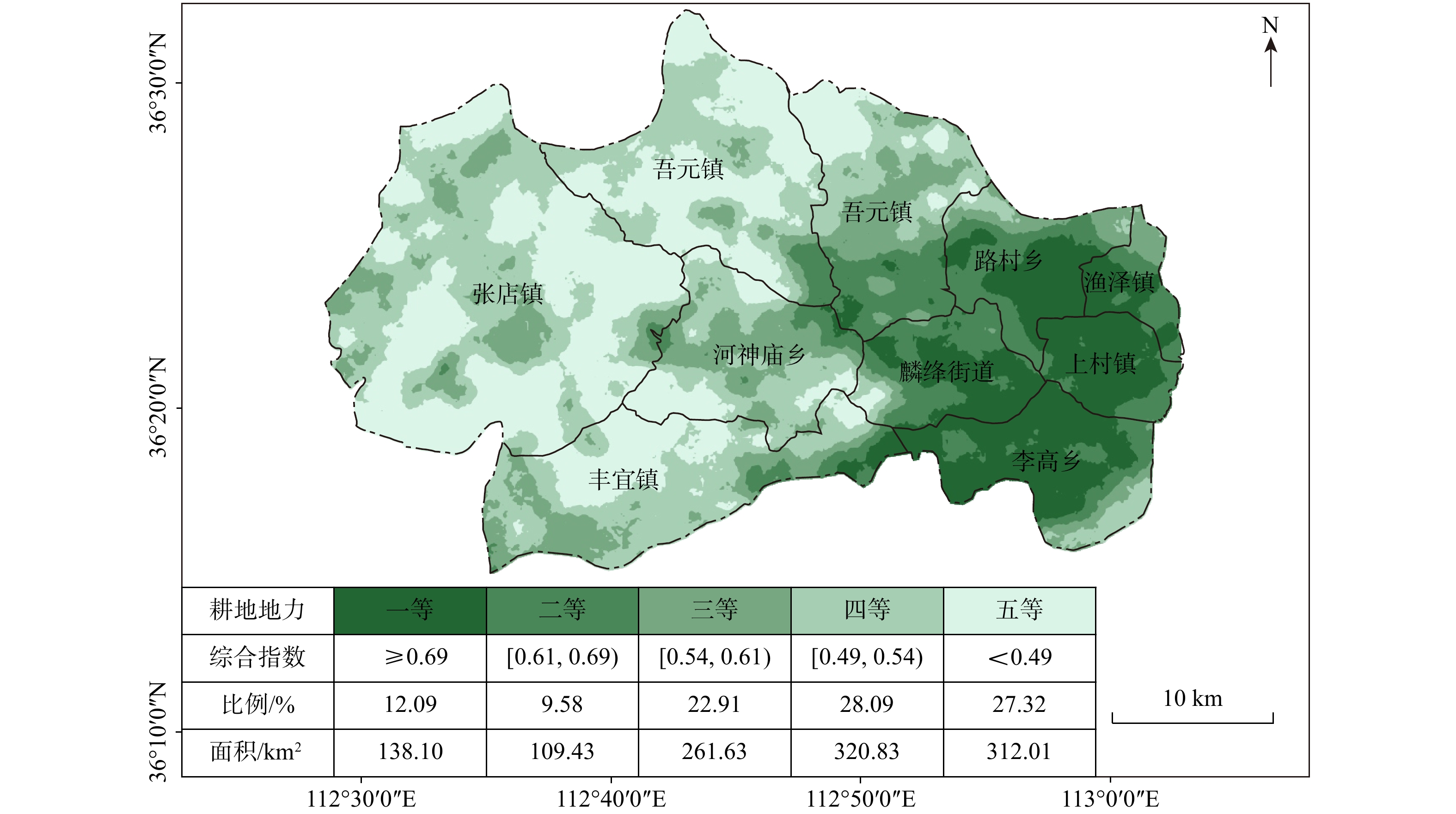
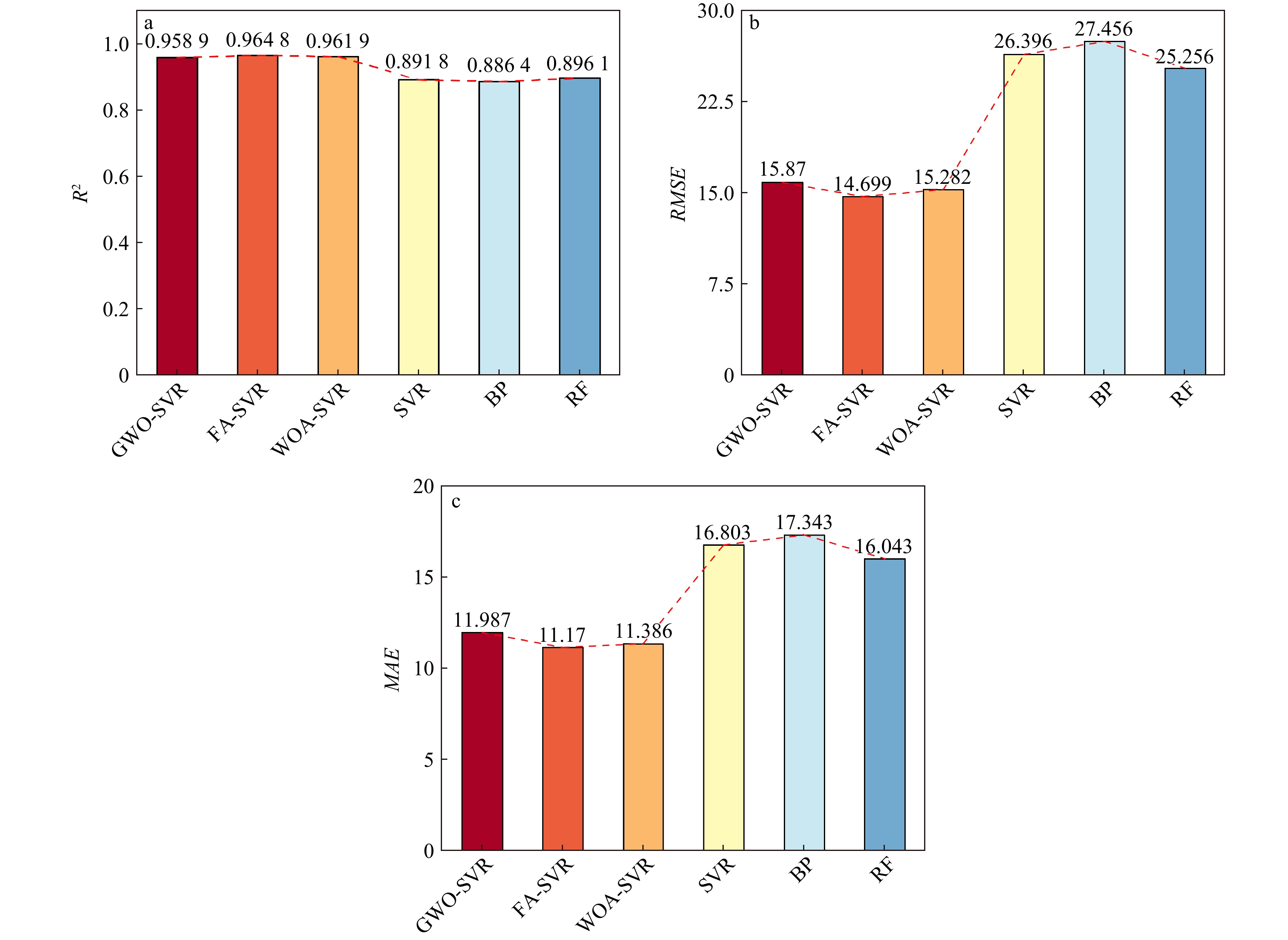
Abstract:
[Objective] Carbon capture and storage (CCS) is crucial in combating global climate change, and deep saline aquifers have the largest identified storage potential, making them the preferred storage location. However, when CO2 is injected underground, it tends to escape through interconnected fractures or reactivated faults toward the ground due to buoyancy. Thus, studying the impact of CO2 injection on fault and the feedback effect of fault activation on CO2 leakage is significant. [Methods] In this paper, we develop a fully coupled two-phase thermo-hydro-mechanical model to simulate mutual interactions between CO2 injection, fault failure, and CO2 plume propagation. [Results] Modeling results demonstrate that the permeability distribution exhibits a notable dichotomy upon fault activation. Furthermore, the evolution of fault permeability is intimately coupled with the spatio-temporal changes in the pore pressure field. As the initial failure zone transforms into a high-permeability area, it facilitates the release of pore pressure, dampening further fault activation, and leading to localized activation characteristics. In addition, the migration range of CO2 plumes cannot be trivially equated with the cooled zone in the rock mass. The plume dispersal is rapid and extensive, reaching a frontal migration distance of up to 1500 m after just two years of constant injection. In contrast, the diffusion of the temperature field is slow and concentrated, yielding a cooled area of only 200 m after 20 years of constant injection. This constrained temperature field pattern is less prone to inducing fault activation, thereby contributing to the long-term safety of carbon sequestration projects. Finally, fault configuration exerts a significant influence on the long-term safety of CO2 storage, with reverse faults exhibiting the best sealing performance, normal faults the worst, and strike-slip faults falling in between. Specifically, the effective CO2 storage capacity of the reverse fault is approximately 25% higher than that of the normal fault. [Conclusion] In conclusion, the established two-phase thermo hydro mechanical model incorporating damage behavior demonstrates robust performance, accurately capturing the intricate interaction mechanisms between fault progressive failure and CO2 plume migration. This model provides both theoretical and technical support for the long-term safety assessment of carbon sequestration projects.
Probabilistic stability analysis of rock slopes with coupled determining and random discontinuities
CHANG Zhilu, YU Qi, ZHONG Min, JIANG ShuiHua, XIANG Hui, GUAN Hongtao, MENG Jingjing, HUANG Faming
, Available online  , doi: 10.19509/j.cnki.dzkq.tb20240388
Abstract:
Objective

Stability analysis of rock slopes is crucial for ensuring the normal construction and safe operation of engineering facilities. Instability of slopes can cause severe casualties and economic losses. The widespread presence of determining and random discontinuities within rock slopes leads to rock mass discontinuity and heterogeneity, significantly affecting slope stability, deformation characteristics, and failure modes. Therefore, studying the development characteristics of discontinuities and their influence on slope stability is vital for slope protection and disaster prevention. However, existing studies rarely consider both determining discontinuities and random discontinuity networks when constructing rock slope models for probabilistic stability analysis and failure mechanisms.

Methods

In this study, a three-dimensional numerical slope model was constructed using Rhino software. The discrete fracture network (DFN) model was applied to generate both determining and random discontinuity networks based on field discontinuity data. A coupling analysis model for random discontinuities was then developed by integrating the slope model and discontinuity networks via 3DEC software. A probabilistic stability analysis method was proposed to analyze the effects of random discontinuities on slope stability. Finally, the proposed method was demonstrated using a simplified rock slope model to assess the impact of random discontinuity networks on slope stability, along with a probabilistic stability analysis of the left bank shoulder slope of the Jinping I Hydropower Station under natural and excavated slope conditions.

Results

The results indicate that (1) The proposed method effectively and accurately simulates both the deterministic and random discontinuity networks, as well as coupling the discontinuity network with the rock slope model. (2) The probabilistic distribution of the slope stability coefficient can be obtained, and the results are more comprehensive and aligned with engineering practice. (3) The random discontinuity network has a greater impact on slope stability under excavated slope conditions and alters the failure path and instability mechanism of the rock slope.

Conclusion

The research results provide references for excavation and support schemes for rock slopes in engineering practice and offer a theoretical basis for geological disaster prevention and control.

A review and prospect of research on disaster-causing environment factors related to landslide susceptibility prediction
HUANG Faming, CHEN Jie, YANG Yang, CHEN Xi, ZHOU Chuangbing, JIANG Bingchen, GUO Fei
, Available online  , doi: 10.19509/j.cnki.dzkq.tb20240766
Abstract:
Objective

Disaster-causing environmental factors serve as input variables for landslide susceptibility prediction modeling, referring to various natural attribute factors influencing the occurrence, development, and distribution of landslides on slopes. A comprehensive and clearly-defined set of disaster-causing environmental factors is of vital importance for enhancing the accuracy and reliability of landslide susceptibility outcomes.

Methods

To further clarify the research status and future prospects of disaster-causing environmental factors, this paper conducted a literature search in the core collection database of Web of Science, with the titles containing "landslide susceptibility" and the publication date ranging from 01/01/2013 to 31/12/2023, collecting 767 English papers on landslide susceptibility to form a literature database. Firstly, information such as the quantity of disaster-causing environmental factors, acquisition methods, sources, importance, and acceptance in each paper was statistically analyzed. Then, the definitions and physical meanings of disaster-causing environmental factors were elaborated in detail. Subsequently, characteristics such as the optimization selection/combination methods of disaster-causing environmental factors, factor connection methods, factor errors, and suitability were discussed, providing a reference for the uncertainty research of selecting disaster-causing environmental factors when predicting landslide susceptibility.

Results and Conclusion

The review results indicate that: (1) A total of 82 types of disaster-causing environmental factors were statistically analyzed in the literature database, with over 40 frequently used ones. Among them, slope, aspect, elevation, and lithology are the four most frequently used factors. The importance of factors such as slope, elevation, road density, lithology, and rainfall in landslide susceptibility prediction is the highest in sequence. (2) It was discovered that research on using comprehensive and physically meaningful disaster-causing environmental factors, constructing model input variables based on environmental factor connection methods, eliminating random errors in environmental factors, enhancing the suitability of environmental factors, and employing various explainable methods can effectively improve the performance of machine learning in predicting landslide susceptibility. Therefore, in future research on the disaster-causing environmental factors of landslides, it is necessary to focus on these key issues.

Experimental on CO2 plugging effect and instability condition of hydrate in fracture of seafloor sediments
ZHANG Ju, JI Yuxuan, GUO Huirong, LI Hui, WANG Zhe
, Available online  , doi: 10.19509/j.cnki.dzkq.tb20230651
Abstract:
Objective

Seabed carbon dioxide (CO2) geological sequestration technology has become a hot spot in carbon sequestration and carbon neutralization. There are favorable space and temperature and pressure conditions for the formation of CO2 hydrate in the seabed sediments in the northern part of the South China Sea, and the formation of CO2 hydrate in the cracks and pores can block the further upward migration of CO2 and generate self-sealing capacity. However, the CO2 leakage in the fracture and the effect of hydrate plugging and instability conditions are still unclear.

Methods

In this paper, the visualization experiment platform of hydrate growth and the instability process of water injection supercharging at high pressure and low temperature was used to observe the formation of CO2 hydrate and experiment platform was used to simulate the conditions of seafloor sedimentary cover under the conditions of 2℃ and 3~4 MPa, and the hydrate instability condition and plugging effect were evaluated with the breakthrough pressure, breakthrough pressure difference, duration, permeability coefficient of initial instability stage and plugging rate as indicators.

Results

The experimental results show that hydrate formation can be simplified into four processes: nucleation, expansion, forming and aggregation. Hydrate formed in cracks can efficiently block the migration of fluids such as water and CO2, but the instability phenomenon begins when the fluid pressure gradually increases and reaches the critical breakthrough pressure. The instability process of hydrate can be simplified into two parts: particle size degradation and surface friction failure. The core of hydrate mass is unstable first, and the sealing state can be maintained before the surface of hydrate fails to friction fracture. The instability conditions of hydrate in the fracture are investigated experimentally. The breakthrough pressure is 6.414~6.966 MPa and the breakthrough pressure difference is 2.403~3.203 MPa. The instability rate of hydrate is mainly affected by the flow rate, followed by the saturation of hydrate, and the flow rate affects the instability rate through the interface effect. The key factors determining the breakthrough pressure of hydrate are temperature and pressure conditions, while the effect of flow rate is mainly reflected in regulating the specific time when hydrate enters the instability state. Under the condition of 3~4 MPa seafloor sedimentary cover, the sealing rate is 99.0~99.6% and the permeability coefficient of initial instability stage is 0.555~1.260 md.

Conclusion

The experimental results provide a reference for the risk assessment of the overlying layer under similar conditions in the South China Sea for CO2 seabed geological sequestration. The difference between the pressure under the capped CO2 hydrate layer and the actual pressure on the seabed should be ensured to be less than 2 MPa to maintain the sealing effect of the hydrate.

Method study of calculating the permeability coefficient of fractured rock mass with dense sections
WEI Juanhua, FU Hao, TANG Zhaohui, ZHANG Tengfei, CHAI Bo
, Available online  , doi: 10.19509/j.cnki.dzkq.tb20230680
Abstract:
Objective

The seepage of fractured rock masses has non-uniformity and anisotropy, and its complexity is reflected in parameters such as density, orientation, and trace length of individual fractures, as well as the connectivity of fracture networks. The connectivity of fracture networks is a difficult problem in calculating the seepage parameters of three-dimensional fractured rock masses. At present, the calculation methods for seepage parameters of three-dimensional fractured rock masses have their own advantages and disadvantages due to different models. To analyze the hydraulic anisotropy and permeability coefficient of fractured rock masses, a new method for solving the permeability coefficient of three-dimensional fractured rock mass dense sections based on dimensionality reduction is proposed.

Methods

This method, founded on the simulation of three-dimensional fracture networks, approximates the fractured rock masses through dense sections in different directions, decomposing the three-dimensional fracture network into multiple continuous two-dimensional sectional fracture networks, using graph theory to analyze the hydraulic connectivity and permeability paths, and water head boundary conditions are set to calculate the permeability coefficient. Through the relationship between lines, surfaces, and volumes in space, the calculated permeability coefficient in two-dimensional space is expressed as the directionality in three-dimensional space, and the permeability tensor of the three-dimensional fractured rock mass network is constructed.

Results

By treating the section permeability coefficient as a permeability ellipse, the new method calculates the equivalent permeability coefficient of the section and provides a solution formula for the equivalent permeability tensor of the rock mass. It also discusses the scale effect and the representation of anisotropy in the rock mass. By constructing three-dimensional and two-dimensional fracture networks, different sizes of unit cells were intercepted to calculate the permeability coefficient, and the side length of a typical unit cell was determined to be 20m. The feasibility of the method was verified through field drilling water pressure experiments.

Conclusion

This method offers a reference for solving the permeability coefficients in different directions of heterogeneous fractured rock masses of various scales.

Application of five-dimensional seismic prediction method based on amplitude attribute in Shunbei X well area
LI HongYan, GONG Wei, HAN Jun, ZHANG YongSheng
, Available online  , doi: 10.19509/j.cnki.dzkq.tb20240328
Abstract:
Objective

In response to the problems of strong reservoir heterogeneity, low signal-to-noise ratio of seismic data, insufficient prediction accuracy of post stack reservoirs, and difficulty in identifying fractures in the ultra deep carbonate reservoirs in Shunbei, a new method for improving the prediction accuracy of fractured reservoirs is explored based on five dimensional seismic data.

Methods

Based on the study of the reservoir development characteristics of the Shunbei fault controlled fracture cave type oil and gas reservoir, this article conducts five dimensional seismic anisotropic forward simulation, establishes the relationship between seismic amplitude and fracture parameters, and optimizes the sensitive parameters for fracture prediction; Based on this, derive the Fourier series form of the directional elastic impedance equation, carry out fracture type reservoir prediction, and apply it in the Shunbei X well area.

Results

Through research, the AVAZ seismic response characteristics of ultra deep carbonate rock fault controlled reservoirs have been clarified, and it is pointed out that fracture density is a sensitive parameter indicating fractured reservoirs; Meanwhile, by utilizing second-order Fourier coefficients to characterize the density of fracture development, a precise characterization of fracture type reservoirs was achieved in the Shunbei X well area, with a high prediction accuracy.

Conclusion

The five dimensional sesmic prediction technology based on amplitude attributes enriches the prediction of fracture development density and direction by mining amplitude and orientation information of wide azimuth seismic data. The established Fourier coefficient fracture density mapping relationship provides a quantitative prediction tool for fracture controlled fracture cave reservoirs, and offers new ideas for fracture prediction and target evaluation in fracture controlled fracture cave reservoirs.

Research on comprehensive evaluation and utilization of selenium-rich land quality in Tunliu District, Shanxi Province, China
WANG Daying, CUI Xinyu, CAO Peili, CUI Jie, ZHANG Shiyu, FAN Wenhua, FENG Zhiqiang, HE Junchen, LEI Yong
, Available online  , doi: 10.19509/j.cnki.dzkq.tb20230666
Abstract:
Objective

Carrying out land surveys and evaluations and developing special industries is a very important task for China to realize rural revitalization and consolidate the results of poverty alleviation. In order to more accurately and effectively guide regional agricultural production layout and specialty industry development, a selenium-rich land survey and evaluation was conducted in Tunliu District, Changzhi City, Shanxi Province, China.

Methods

Therefore, the indicators of selenium-rich industry quality, ecological environment and arable land strength were selected to construct a comprehensive quality evaluation system for selenium-rich land, and then fuzzy mathematical method, entropy weighting method, and composite index method were applied to evaluate and grade the land in the study area, and ArcGIS was used to implement the results.

Results

The results show that: ① the land with soil selenium content grades of high selenium and moderate selenium in Tunliu District accounted for 54.47% of the statistical area, and these soils were concentrated in the eastern part of the district; the distribution of cultivated land strength grades in Tunliu District was uneven, and the overall characteristics showed that it was low in the western part and high in the eastern part; the results of the evaluation of ecological environment grades were clean in the whole district. ② There are 299.33 square kilometers of selenium-enriched land in Tunliu District with comprehensive quality grade of first class, accounting for 26.61% of the statistical area, and concentrating in the plain area in the east. ③ Wheat, sharp peppers and green peppers in Tunliu have reached the standard of selenium enrichment of crops. Among them, the selenium enrichment rate of sharp peppers is 100%. In addition, the results of heavy metal element testing show that the crops in the district are in good clean condition.

Conclusion

Based on the evaluation results of land and crops, and in conjunction with the spatial planning of land in Tunliu District, the land is divided into three types: A, B and C. Among them, type A land is characterized by high soil selenium content, rich nutrients and clean environment, so it is recommended to build selenium-enriched wheat and green vegetable planting bases in the area where this type of land is concentrated and develop tourism agriculture at the same time. Class C land is characterized by low soil selenium and nutrient content, which is unsuitable for planting crops, so it is recommended to build deep-processing factories for agricultural products in the areas where this type of land is concentrated, and to develop agricultural trade and tourism at the same time. It provides theoretical support and scientific suggestions for the planning of selenium-rich agriculture industry in Tunliu District and the synergistic development of the region.

Prediction of Squeezing Surrounding Rock Tunnel Deformation Based on Support Vector Regression Optimized by Swarm Intelligence Algorithm
XU Jianbo, YAO Tianyu, WANG Li, ZHU Songyang, LUO Xuedong
, Available online  , doi: 10.19509/j.cnki.dzkq.tb20230675
Abstract:
Objective

In tunnel engineering, the prerequisite for tunnel design and construction safety is to accurately assess the amount of deformation of tunnel surrounding rock.

Methods

In this paper, the Firefly Algorithm (FA), Whale Optimization Algorithm (WOA) and Gray Wolf Optimization Algorithm (GWO) are combined with optimized Support Vector Regression (SVR), and based on which three hybrid swarm intelligent optimization prediction models are constructed to predict deformation of extruding surrounding rock tunnels. A database containing 62 samples was constructed, and seven initial parameters of tunnels and surrounding rocks were selected as the input parameters of the prediction models, and the radial deformation of tunnels as the output quantities. The coefficient of determination (R2), root-mean-square error (RMSE), and mean absolute error (MAE) were selected as the evaluation indexes of the model prediction effect. Finally, the effects of different input parameters on the prediction results of tunnel rock deformation were evaluated using normalized mutual information values.

Results

The FA-SVR model demonstrated superior predictive performance during both the training and testing phases compared to the GWO-SVR and WOA-SVR models. For the training set, the corresponding R2 values were 0.9634 and 0.9648, respectively, while the RMSE values were 18.786 and 14.699, and the MAE values were 9.460 and 11.170. The ranking of predictive capability was as follows: FA-SVR > WOA-SVR > GWO-SVR.

Conclusion

The results show that the firefly algorithm, the whale optimization algorithm and the gray wolf optimization algorithm can improve the prediction performance of the support vector regression model, the FA-SVR model has the best prediction effect, and the optimized hybrid prediction model performs significantly better than the classical models. The sensitivity analysis shows that joint frequency is the most important parameter that affects the predicted value of deformation of tunnel surrounding rock.

Recognition of structural plane and stability analysis of high steep rocky slope based on 3D point clouds
XI Wang, CHEN Yiwei, ZHANG Wenguang, BIAN Linsong, MEN Lin, LIANG Pengfei, ZHOU Bo
, Available online  , doi: 10.19509/j.cnki.dzkq.tb20230667
Abstract:
Objective

The distribution of structural planes plays a significant role in determining the engineering and mechanical properties of rock masses. Accurately obtaining information about structural planes is crucial for analyzing the characteristics and stability of rock masses.

Methods

Three-dimensional point cloud data of a steep rock slope was acquired using 3D laser scanning technology. After the filtering preprocessing of the point cloud data, the open-source program Discontinuity Set Extractor (DSE) was then used to semi-automatically recognize and classify the point cloud data, obtaining key parameters and clustering information of the slope rock mass structural planes, such as attitude, trace length, and spacing. By fitting the point cloud clustering information, a probability distribution model was created, and a Discrete Fracture Network (DFN) model was established. Furthermore, a three-dimensional block discrete element model of the steep slope was developed using the "Rhino-Griddle-3DEC" integrated modeling method based on the point cloud data. The model investigated the stability of slope and potential failure area.

Results

The results show that under the gravity condition, the safety factor of the whole slope is about 1.5 and the potential unstable area is the dangerous rock mass located on the top of the slope.

Conclusion

Therefore, the structural plane parameters identified by this method can better reflect the engineering properties of the rock mass, providing important guidance for the analysis and evaluation of the stability of steep rock slopes.

Characterization of the present-day lithospheric thermal structure and main controlling factors in Songliao Basin
DAI Dengliang, WANG Shouzhi, BIAN Yuan, WANG Peng, LIU Zongbao, ZHAO Rongsheng
, Available online  , doi: 10.19509/j.cnki.dzkq.tb20230609
Abstract:
Objective

Thermal structure analyses in the Songliao Basin are mostly confined to the sedimentary scale in the north-south zoning, and the lack of basin-wide thermal structure portrayal at the lithospheric scale constrains the genesis analysis in a geodynamic background.

Methods

Based on the published parameters of surface heat flow, geothermal gradient and thermophysical properties, this paper supplements the thermophysical properties of Yaojia Formation, Qingshankou Formation and Quantou Formation, and adds several geothermal field data to comprehensively characterize the geothermal field of the whole Songliao Basin, and analyze the characteristics of the present-day lithospheric thermal structure.

Results

The results show that the geothermal gradient in Songliao Basin ranges from 21.10 to 63.45℃/km, with an average value of 41.41℃/km, which is higher than the global average value of 30℃/km; the distribution of surface heat flow values ranges from 30.38 to 106.58 mW/m2, with an average value of 71.85 mW/m2, which is higher than the global average value of 60 mW/m2 and belongs to a typical "hot" basin. Under the influence of the Pacific plate subduction, the delamination and thermal erosion made the thinned thickness of the thermal lithosphere of 58.59 km. The heat flow contribution by radioactive elements in the thinned crust is only 16.40 mW/m2, accounting for 22.83% of the surface heat flow; and under the influence of the dehydration of the stagnant plate, part of the molten mantle heat material is upwelled, the mantle heat flow contributes as high as 55.45 mW/m2, accounting for 77.17% of the surface heat flow.

Conclusion

Therefore, controlled by lithospheric thinning and mantle upwelling, the Songliao Basin has "hot" basin properties and "hot mantle and cold crust" lithospheric thermal structure characteristics.

Characteristics and causes of difference of physical properties of deep and ultra deep tight sandstone reservoirs: A case study of the Bashijiqike Formation in Bozi area of Kuqa Depression
JIANG Xiaojun, SHI Lingling, MO Tao, YANG Haijun, DU Hao, SHI Wanzhong, DONG Guoning
, Available online  , doi: 10.19509/j.cnki.dzkq.tb20230567
Abstract:
<p>Despite depths exceeding <styled-content style-type="number">8000</styled-content> meters, it still retains high-quality reservoir and exhibits prolific production of industrial gas flow in Bozi area of Kuqa Depression. However, there are obvious differences in the physical properties plane of the tight sandstone reservoirs of the Bashijiqike Formation. </p></sec><sec><title>Objective

In order to clarify the development characteristics of such reservoirs and reduce the risks associated with deep-ultra-deep oil and gas exploration.

Methods

Based on the experimental analyses of well logging, thin section petrography, high pressure mercury injection and PVT phase diagrams, the characteristics of tight sandstone reservoirs and the causes of physical property differences were discussed.

Results

The rock types of Bashijiqike Formation reservoir in Bozi area which the study highlights are medium-fine grained lithic feldspar sandstone and feldspar lithic sandstone. Notable differences exist in the spatial distribution of carbonate cement content. Original porosity in the medium-fine sandstone reservoirs that ranges from 32.4% to 38.1%, exhibiting comparable intergranular compaction strength primarily reliant on point-line contacts. Southern reservoirs maintain an average porosity of 8.6% and an average permeability of 3.4mD. Central reservoirs present an average porosity of 6.53% and an average permeability of 0.65mD. The average porosity and permeability of the northern reservoir are 4.9% and 0.62mD respectively. Primary intergranular pores dominate the southern reservoir space, whereas residual intergranular pores and dissolution porosity prevail in the northern and central zones. Furthermore, superior pore-throat structures characterize the southern region compared to the northern and central sectors.

Conclusion

The physical properties of sandstone reservoirs in Bozi area are controlled by sedimentation, diagenesis and tectonic processes (fissures), among which carbonate cementation emerging as the principal factor of the late reservoir physical properties alterations. Overpressure, hydrocarbon fluid charging, and fracture development significantly affect carbonate cementation, subsequently causing variations in reservoir physical properties. Stronger overpressure, earlier oil and gas charging time and limited fracture filling result in better reservoir properties in southern Bozi than those in northern and central areas.

Identification of karst micropaleogeomorphology and reservoir characteristics of Maokou Formation in Yunjin area, South Sichuan
LIU Zhen, LIU Peng, WANG Peng, LIU Zhigang, WEN Yinyu
, Available online  , doi: 10.19509/j.cnki.dzkq.tb20230576
Abstract:
Objective

The development of karst reservoirs in the Maokou Formation of the Lower Permian in southern Sichuan is a key formation for conventional oil and gas exploration in southern Sichuan. The development level of supergene karst reservoirs is directly controlled by the rich and varied karst microgeomorphology, resulting in strong lateral heterogeneity of karst reservoirs.

Methods

This paper uses 3-D seismic data, combined with strata thickness, gradient structure tensor attributes, and geological body carving techniques, to characterize the microgeomorphic characteristics of Dongwu karst in the Yunjin area. Predicting favorable zones for surface karst reservoirs through model forward modeling and amplitude attributes.

Results

Research suggests that:①The Yunjin area had significant differences in karst micro- geomorphology during the Dongwu period, with a series of karst caves developed, which exhibited a seismic feature of "pull-down" of the seismic event event axis at the top boundary of the Maokou Formation;②Effectively characterizing the distribution pattern of karst collapse bodies in Yunjin syncline area using gradient structure tensor attributes combined with geological body carving technology. There are three distribution patterns of karst collapse bodies on the plane: isolated, linear, or contiguous;③The seismic amplitude on both sides of the edge of the karst collapse body is weakened, and the karst process is strong, with the development of karst caves, which is a favorable zone for reservoir development.

Conclusion

This research result has guiding significance for the subsequent prediction of Maokou Formation reservoirs.

Spatial characteristics and genetic mechanism of geothermal resources in Zhangye Basin by multi-source fusion modeling and heat-flow coupling simulation
YIN Zheng, CHEN Qingxiang, HE Jianbo, WANG Chunlei, LUO Jin
, Available online  , doi: 10.19509/j.cnki.dzkq.tb20230590
Abstract:

The traditional temperature and pressure field analysis approach is based on the interpolation of existing borehole data, which cannot accurately represent the seepage-heat transfer coupling process of geothermal resources, resulting in insufficient understanding of the genetic mechanism of geothermal resources. To overcome the drawbacks of the conventional approach, this paper built a three-dimensional geological model of Zhangye Basin by combining multi-source data including borehole information, geophysical information and elevation data. Compared with the traditional model, multi-source data fusion modeling can improve the accuracy of inter-hole strata by 50-300 m. The numerical simulation of basin seepage-heat transfer field coupling process shows that the multi-field coupling analysis describing the temperature and pressure field more reasonable than that of key-point-spatial-interpolation approach. The analysis shows the higher water head in the southeast of the basin and relatively lower heat in the northeast. this leads to the geothermal water flows from southeast to northwest and was heated up during the seepage process, and the heat was lost later when the burying depth of the reservoir becomes shallower and the cap becomes thinner. As a result, the higher temperature was determined in the basin center which can reach up to 78℃ and the lower temperature was observed in the areas surrounding with the center. Finally, a 3D geothermal conceptual model is developed to better understand the genetic mechanism of geothermal resources in terms of structural, hydrogeological, and geothermal geological perspectives. This 3D conceptual mode coupling with heat-flow transfer modeling more specifically explains the spatial distribution and reveal more clearly the underlying mechanism of forming the geothermal resources compared with conventional 2D model.The study showed the groundwater in the reservoir flows from south-east toward north-west and revealed also the formation of the rhombic-lobe shaped distribution of geothermal resources in the basin, which provides theoretical basis for the precise localization of high potential geothermal zones and for the sustainable development of geothermal resources.

Effects of concentrated recharge conditions on hydrological processes and pollution responses of karst underground rivers
ZHOU Zhihao, LUO Mingming, CHEN Jing, PENG Xiangyu, ZHAO Zehao, ZHAO Wenhui
, Available online  , doi: 10.19509/j.cnki.dzkq.tb20230566
Abstract:
Objective

Concentrated recharge conditions often significantly impact the water quantity and quality of karst underground rivers. Therefore, it is of great importance to clarify the effects of different concentrated recharge conditions on these aspects.

Methods

Based on hydrogeochemical surveys, this study simultaneously monitored the hydrological and hydrochemical dynamics at the sinkhole entrance and underground river outlet of the QLK underground river system in western Hubei, to explore the impacts of different recharge conditions on the water quantity and quality of the underground river.

Results

The results show that recharge intensity and soil moisture content directly control the generation and convergence processes of flow within the sinkhole, as well as the flow response of the karst underground river system. Rainfall events that do not reach a threshold will not trigger a flow response in the underground river.As concentrated runoff converges towards the sinkhole entrance, the concentrations of various hydrochemical ions increase significantly.The hydrochemical response observed at the outlet of the QLK underground river system is influenced by the intensity of recharge. Under heavy rainfall conditions, this response is further intensified due to the enrichment of hydrochemical ion concentrations at the sinkhole entrance.Following heavy rainfall, TIN (Total Inorganic Nitrogen) and phosphates accumulate at the sinkhole entrance, leading to concentrations that are 2 to 3 times higher than the natural background levels. Pollutants introduced through concentrated recharge directly contaminate the underground river. In the hydrochemical response, N-${\mathrm{NH}}_4^+ $ enters the karst water cycle prior to N-${\mathrm{NO}}_3^- $, and the fluxes of nitrate and TIN increase at the outlet of the underground river system relative to the inlet. Meanwhile, the flux of ammonium N-${\mathrm{NH}}_4^+ $ gradually decreases over time as recharge occurs, suggesting nitrification reactions within the conduits.

Conclusion

The results of this study can provide a scientific basis for pollution prevention and control, as well as water environmental management of karst underground rivers.

Bonding performance of anchor-mortar interface under multifactor action based on electrochemical impedance analysis
WANG Xuchen, KE Rui, WANG Liangqing, ZHU Yue, ZHENG Luobin, SUN Zihao
, Available online  , doi: 10.19509/j.cnki.dzkq.tb20230622
Abstract:
Objective

There are many factors affecting the bonding performance of the anchor-mortar interface, and the current research on the bonding performance of the interface focuses on the influence of a single factor, while the research on the bonding performance of the interface under the action of multiple factors still leaves a gap.

Methods

In this paper, we take the anchor-mortar as the research object, using electrochemical impedance spectroscopy to obtain the state of the anchor-mortar interface and electrochemical parameters under different influencing factors, obtain the bond strength of the anchor-mortar interface through the pullout test, and combines the electrochemical parameters to investigate the relationship between the electrochemical parameters and the pullout load when the specimen maintenance is completed and analyses the influence of the three factors on the bonding performance of the interface between the anchor-mortar.

Results

The sensitivity analysis of orthogonal test shows that the pull-out load of the specimen is mainly controlled by the diameter of the anchor rod, the pore solution resistance (Rs) is mainly controlled by the water-cement ratio, and there is no obvious controlling factor for the charge transfer resistance (Rct); at the early stage of specimen maintenance, under the influence of the three factors, there will be two kinds of states of the anchor-mortar interface, namely, complete passivation film and incomplete passivation film. The results of the study show that, within the range chosen for the test, the pullout load increases with the increase of fine sand particle size and the decrease of water-cement ratio, and the pullout load of the specimen is positively correlated with the pore solution resistance (Rs) and charge transfer resistance (Rct).

Conclusion

The research results are of great significance for the validation of the effectiveness of anchored structural mortar proportioning and application.

Spatial distribution of earthquake-induced landslide in densely populated area of the Luding 9·5 earthquake
SONG Jingyuan, LIU Yang, DONG Xiujun, YUAN Yangjie
, Available online  , doi: 10.19509/j.cnki.dzkq.tb20230619
Abstract:
Objective

Studying the spatial distribution law of earthquake-induced landslides can not only provide an important basis for the investigation of hidden dangers of geological disasters in disaster areas, but also be of great significance for post-disaster reconstruction, post-disaster resettlement and site selection, and geological disaster prevention and control.

Methods

Taking the earthquake with Ms6.8 in Luding County, Ganzi, Sichuan Province on September 5, 2022 as an example, firstly, based on the optical image (DOM) with 0.2m resolution and the digital elevation model (DEM) with 0.5 m resolution obtained after the earthquake, the earthquake-induced landslides were interpreted by artificial visual three-dimensional remote sensing, and then combined with field investigation and correction, the final number of earthquake-induced landslides was determined. On this basis, the relationship between the geological background such as topography, geological structure and seismic factors and the distribution of earthquake-induced landslides was analyzed.

Results

①The Luding earthquake event triggered 9248 landslides in the study area of about 680km2, mainly small and medium-sized landslides, and the highest area density of landslides was concentrated in the intersection of Xianshuihe fault, Daduhe fault and Jinping mountain fault. The total landslide area is about 45.57 km2, and the average landslide area can reach 4941m2; ②The distribution of landslides in this earthquake is mainly influenced by PGA and fault structures, and most of them are distributed within the range of PGA> 0.6 g and 1km from both sides of the seismogenic fault; In addition, the development of landslide is negatively related to the distance from water system and road; Locally influenced by topographic factors, it mainly develops at the elevation of 1200-2400 m, the slope is 30-60, and the slope is eastward and southeast, and the stratum lithology is mostly hard rock; ③The relationship between the number and area of landslides and magnitude of Luding earthquake also follows exponential distribution; At the same time, due to the high accuracy of the basic data of this interpretation, the number of earthquake landslides obtained by interpretation is more than that of other documents, with a smaller minimum area and a larger total area.

Conclusion

The results obtained in this study have been applied to the post-disaster recovery and reconstruction in Luding earthquake-stricken area.

An artificial neural network for standard penetration blow counts of karst soil strata in Shenzhen
YAN Hui, LIN Peiyuan
, Available online  , doi: 10.19509/j.cnki.dzkq.tb20230705
Abstract:
Objective

This study addresses the threat of potential karst geological disasters to the core cities of the Guangdong-Hong Kong-Macao Greater Bay Area, such as Guangzhou and Shenzhen, impacting the safety and development of their underground spaces. Standard penetration testing, a crucial method for investigating karst strata, plays a vital role in soil layer classification, load-bearing capacity evaluation, and foundation selection. However, traditional standard penetration tests can escalate project costs and are significantly influenced by the skill level of the operators.

Methods

To deal with these challenges, this paper introduces a new method for rapidly and accurately obtaining standard penetration test data in karst areas. Focusing on the karst regions of Shenzhen, we collected 1006 sets of soil penetration data and developed a single hidden layer neural network model with an 11-5-1 structure; this model is featured by only five neurons and has an analytical form that enables easy computation.

Results

The research findings reveal that this neural network model has a high determination coefficient of 0.93, indicating its high accuracy in prediction. The model factor has a mean value of 1.04, with a coefficient of variation (COV) ranging between 9% and 23%. Overall, the model demonstrates high precision and low predictive dispersion. The paper thoroughly examines various factors affecting the model's stability and predictive performance, including the number of neurons in the hidden layer, data normalization methods, choice of activation functions, data splitting ratios, and the impact of random sampling. The practical applicability of this neural network model has been validated through its implementation in two independent engineering projects in the Longgang District of Shenzhen.

Conclusion

This study offers significant insights for the advancement of engineering survey methods in karst regions.

Research on the mechanical model and pipe diameter optimization of a pipe jacking roof in river crossings according to the Pasternak Elastic Foundation Beam
NIU Ye
, Available online  , doi: 10.19509/j.cnki.dzkq.tb20230594
Abstract:
<p>The analysis of the force characteristics of the support pipe is the basis for the structural design of the pipe jacking roof, which ensures the safety of tunnel excavation. </p></sec><sec><title>Objective

In order to analyze the mechanical behavior of the pipe roof during tunnel excavation,

Methods

an analytical model of the support pipe at the bottom of the pipe jacking roof is constructed based on the Pasternak elastic foundation beam theory, making full use of the displacement, rotation, bending moment, and shear continuity conditions to derive the displacement and internal force equations of the support pipe.

Results

The calculation results are in close agreement with the measured strain from the project, proving the applicability of the model. Moreover, by analyzing the maximum strain change law of the support pipe, the reasonable pipe roof diameter was selected, using the pipe jacking roof of the Qinhuai New River section as an example.

Conclusion

The research shows that the initial pipe diameter significantly influences the support performance of the bottom support pipe, with this influence gradually decreasing as the pipe diameter increases. The excavation step length and pipe spacing positively impact the support performance, with a more pronounced effect on the maximum strain of the support pipe when the pipe diameter is small. Pipe spacing has minimal effect on the longitudinal strain of the support pipe. The unloading lever of the pipe jacking roof can effectively transfer the unloading value from the excavation area to the unexcavated area, thus ensuring the stability of the excavation surface of the pipe jacking roof.

Spatial evolution of hydrogeochemistry driven by river water-groundwater transformations in the Manas River Basin
MA Wenjing, WANG Wenke, HOU Xinyue, JI Deshuai, MA Zhitong
, Available online  , doi: 10.19509/j.cnki.dzkq.tb20240360
Abstract:
Objective

The mutual conversion between river water and groundwater plays a crucial role in influencing the composition and evolution of hydrochemical components, and thus, has a significant impact on the water ecological environment. Hence, it is critical to gain a comprehensive understanding of the sources and evolution mechanisms of its hydrochemical components. The complex interactions between river water and groundwater can lead to alterations in the chemical constituents, which may have far-reaching consequences for the overall health and stability of the aquatic ecosystem.

Methods

This work focused on the Manas River Basin, which is located in a typical arid area of China, as the research area. A series of advanced methods were involved in this work, including hydrochemical diagrams (provide a visual representation of the chemical characteristics); ion ratio coefficient analysis (helps in determining the relative proportions of different ions); and inverse hydrogeochemical evolution (allows for a detailed exploration of the historical changes in the water chemistry). Through these methods, an in-depth study is carried out on the hydrochemical characteristics of river water and groundwater in different landforms within the basin, as well as the sources of major ion components and the evolution laws.

Results

These results obtained from the research are highly revealing. It is found that with the changes in landforms and the conversion relationship between river water and groundwater, the hydrochemical types of river water and groundwater experience a progressive evolution. Initially, they are mainly of the HCO3·SO4-Ca type, but gradually transform into the Cl-Na type. The natural driving factor responsible for these hydrochemical changes also shifts. In the disconnected segment, the hydrochemical type of water bodies is predominantly HCO3·SO4-Ca, and the main influencing factor is diafiltration. In the upper reaches of the river-groundwater exchange section, it is mainly SO4·Cl-Na type water, where leaching and mixing are the dominant processes. In the lower reaches of the interaction section, the hydrochemical type is mainly Cl-Na, which is dominantly affected by evaporation. The results of inverse evolution further quantitatively analyze the influence of water-rock interaction in the research area. Along the direction of groundwater flow, specific chemical reactions occur. For example, the precipitation of albite and anorthite takes place, while the dissolution of dolomite, gypsum, Ca-montmorillonite and rock salt is observed. Additionally, positive cation exchanges of Na-Mg and Ca-Mg are also detected.

Conclusion

The results of the study can provide a scientific basis for water environment protection and sustainable management in arid and semi-arid regions.

Genetic mechanism of low resistance in shale analyzed via triaxial compression tests
GAO Tian, LIU Rui, XU Lu, CHEN Zengyu, LI Jiaming, LONG Siyu, LIAO Qiang, LIU Peng, LI Pengyan
, Available online  , doi: 10.19509/j.cnki.dzkq.tb20230533
Abstract:
Objective

The gas-rich Wufeng-Longmaxi shale of the southern Sichuan Basin exhibits low-resistance anomalies in multiple areas. Statistical analysis reveals that the low-resistivity zone (<10 Ω·m) in the Wufeng-Longmaxi shale is spatially associated with tectonic faults. This study aims to reveal the coupling mechanism between shale resistivity and tectonic faults.

Methods

This study determines the petrological and geochemical characteristics of outcrop samples obtained from the Wufeng-Longmaxi shale in the southern Sichuan Basin through thin-section identification, X-ray diffraction, laser Raman spectroscopy, whole-rock asphalt reflectance, and conventional physical property analyses. The characteristics of resistivity change in the shale during deformation were analyzed through triaxial compression tests. The impacts of fracture system generation and conductive fluid intrusion on low-resistivity shale were also clarified.

Results

The results show that the resistivity of shale samples, which have similar characteristics of clay minerals, pyrite, organic matter content, and thermal maturity level, significantly decreased after saturation with brines of various salinities. A positive correlation was observed between the resistivity reduction (95.07%-98.70%) and brine salinity. After reaching the compressive strength, the resistivity reduction of the brine-saturated samples varies from 5.7 Ω·m to 25.7 Ω·m (average: 13.3 Ω·m). This reduction shows a linearly positive correlation with the resistivity observed post cracking. The intrusion of conductive fluid and the generation of the fracture system in shale are the primary controlling factors for resistivity reduction. The resistivity after cracking is influenced by both the intruded saltwater salinity and fracture density.

Conclusion

This research elucidates the influence mechanism of tectonic fault zones on shale resistivity and enhances the theoretical framework for understanding the genesis of low-resistivity shale, with significant implications for the exploration and development of low-resistivity shale formations.

Application of H2S and SO2 soil-gas geochemical measurements in the Pulang porphyry copper deposit, Yunnan Province
SHEN Qiwu, CHEN zhijun, DONG Qiaofeng, LI Gaoxin, HU Mingchuan, CHEN Xin, YU Zezhang
, Available online  , doi: 10.19509/j.cnki.dzkq.tb20240123
Abstract:
<p>Given the difficulty in identifying and extracting exploration information in covered areas, the search for porphyry copper deposits faces significant challenges. </p></sec><sec><title>Objective

The ore bodies in porphyry copper deposits are primarily low-grade metal sulfides, and further research is needed to determine the depth and extent of these deposits via gas geochemistry.

Methods

Preliminary experiments were conducted in this study using a portable gas analyzer for H2S and SO2 geochemical measurements at the Pulang porphyry copper deposit.

Results

The results indicate significant H2S and SO2 geochemical anomalies above copper mineralization, suggesting the method's efficacy in revealing hidden ore bodies and predicting their strike and dip extensions.

Conclusion

Areas showing good synergistic behavior, continuous anomalous concentration distributions, and potential for mineralization are promising targets for exploration. This approach represents an effective method for mineral exploration in covered porphyry copper deposits, offering new insights into prospecting concealed mineral resources.

Test study on the toppling mode of steep bedding rock slope
WANG Linkang, ZHENG Zihan, ZHANG Guangcheng, ZENG Xin, DING Bingdong, BENG Xingtao
, Available online  , doi: 10.19509/j.cnki.dzkq.tb20230550
Abstract:
<p>There are a large number of steep bedding rock slopes along the left bank of Dahuaqiao Hydropower Station in the middle and upper reaches of Lancang River. The unique engineering geological conditions in the reservoir area provide a good breeding environment for deformation. The landslide deposits formed by the collapse of the toppling deformed body are widely distributed in the reservoir area, which causes great difficulties for the operation and maintenance of the hydropower project. </p></sec><sec><title>Objective

In this paper, in order to study the evolution process, toppling mode, toppling deformation and failure mechanism of steep bedding rock slope,

Methods

we used the slightly weathered slate on the left bank of the reservoir as a reference prototype for the similar material material, then we choose to use the bottom friction test method to analyze the deformation and failure characteristics of slope under different condition of slope angles, plane inclination angles and structural plane occurrences.

Results

The results show that: ①The main toppling failure mode of the steep bedding rock slope is the tensile-toppling type. In the early stage of evolution, the rock mass at the foot of the slope is the first to topple due to stress concentration, and gradually develops from the front edge of the slope body to the middle and back. The rock mass in the middle of the slope surface also gradually changes from the forward dip to the upright to the reverse dip state, and accelerates to bend and topple towards the free surface under the action of gravity. When the deformation of rock mass reaches a certain extent, it will fracture along the maximum bending part or structural plane, and eventually slip along the tensile fracture plane or even collapse directly. ②By comparing the slope parameters and deformation characteristics of the test models, the 7 groups of model slopes are roughly divided into 3 categories: near-vertical bedding rock gentle slope, steep dip bedding rock steep slope, near-vertical bedding rock steep slope. Compared with slope Angle, the rock layer dip Angle has more influence on the toppling deformation and failure of the steep bedding rock slope. The gently inclined structural plane that is not perpendicular to the plane is more likely to cause the toppling deformation and failure of the steep bedding slope than the one perpendicular to the plane, and the scale of toppling deformation and failure is larger when the slope body develops the inward structural plane compared with the outward inclined structural plane. ③From the perspective of deformation stage, the deformation evolution process of slope is divided into initial deformation stage, toppling deformation stage and toppling failure stage. ④The toppling deformation and failure process of steep bedding rock slope is divided into stress adjustment stage, flexural-creep stage, flexural-sliding stage and toppling-sliding-collapse fracture stage from the mechanism. According to the deformation degree of the toppling area, the deformed slope can be divided into three zones: a strong toppled zone, a weak toppled zone, and a stable zone.

Conclusion

The research results can provide reference for the research of the evolution process, toppling mode, toppling deformation and failure mechanism of steep bedding rock slope.

Fine-grained identification of internal characteristic zones within strike-slip faults via the XGBoost algorithm
ZHAO Jun, WANG Junyu, LAI Qiang, WEN Xiaofeng, WU Guanghui, JIAO Shixiang
, Available online  , doi: 10.19509/j.cnki.dzkq.tb20230584
Abstract:
<p>Because of the strong heterogeneity of fault zones, diverse reservoir types, and complex fluid distributions, the logging responses between damage, fault breccias , and dissolution zones within strike-slip faults are complex and variable, making it difficult to identify the three characteristic zones effectively inside strike-slip faults using imaging and conventional logging data. </p></sec><sec><title>Objective

The extreme gradient boosting (XGBoost) algorithm is introduced to establish a model to improve the identification accuracy of the three characteristic zones within strike-slip faults.

Methods

The logging response characteristics of the three characteristic zones within strike-slip faults are analyzed, and the sensitive logging curves are selected to construct a feature vector space set based on the mean and variance. The XGBoost algorithm is applied to establish XGBoost regression prediction models for the dissolution, breccias, and damage zones of strike-slip faults. The key parameters of the XGBoost model are optimized through multiclass evaluation indicators to improve the identification accuracy of the characteristic zones within strike-slip faults.

Results

The constructed XGBoost model was used to identify the internal characteristic zones of strike-slip faults in the study area, with a total of 234 samples; 208 samples were correctly identified, resulting in an identification accuracy of 88.89%. The prediction results reveal that, within the internal characteristic zones of strike-slip faults, the damage zone has the widest distribution, followed by the breccias zone, and the dissolution zone is the narrowest, which is consistent with the actual distribution of the internal characteristic zones of strike-slip faults.

Conclusion

The identification model of internal characteristic zones within strike-slip faults based on the XGBoost algorithm can be used to effectively identify the damage, breccias, and dissolution zones, thereby supporting more effective analysis of the distribution of small-scale dissolution cavities and fracture reservoir spaces inside strike-slip faults, and providing reference information for the accurate characterization of the internal structure of strike-slip faults.

Controls of Middle and Late Permian major geological events on the development of the organic-rich shales in northeast Sichuan Basin
DENG Kong, LU Yangbo, ZHANG Bolin, LIU Zhanhong, MENG Mianmo, DU Xuebin, CHEN Feiran, LI Fei, LU Yongchao, GOU Qiyang, WANG Hanming
, Available online  , doi: 10.19509/j.cnki.dzkq.tb20240483
Abstract:
Objective

Three sets of black organic-rich shales found in the Permian Dalong Formation, Wujiaping Formation, and Maokou Formation in northeastern Sichuan have yielded significant discoveries in shale gas exploration, presenting new opportunities beyond the established Wufeng-Longmaxi marine shale gas plays.

Methods

This study investigated the lithological characteristics and paleoenvironmental evolution of these formations through petrological and geochemical analyses. A comprehensive examination of the depositional environments and the key controlling factors for organic matter enrichment during the deposition of these organic-rich black shales from the Middle to Late Permian in northeastern Sichuan has been performed.

Results

The findings demonstrate that the three organic-rich shales exhibit considerable heterogeneity, with distinct controlling factors influencing their development. The sedimentary period of the third member of the Maomao Formation was characterized by strong upwelling, weak volcanic activity, and limited hydrothermal activities. This environment featured a warm and humid climate, extremely high primary productivity, low terrestrial input, and anoxic sulfide water conditions. In contrast, the sedimentary environment of the second member of the Wujiaping Formation was marked by high productivity, low continental source input, seasonal upwelling, weak hydrothermal activity, and interstitial sulfidation-sulfidation conditions and driven by strong hydrothermal fluid, upwelling, and island arc volcanic activity. The sedimentary environment of the Dalong Formation also exhibited high primary productivity, low terrestrial input, and interstitial sulfidation-sulfidation conditions.

Conclusion

The research highlights the complex interactions of multiple geological events on organic-rich shales and constructs a genetic model for these shales influenced by various geological factors. This model provides a theoretical basis and supports the identification of favorable areas for marine shale gas exploration.

Bayesian methods for geostatistical variogram model selection and comparative study
ZHANG Yifan, ZHANG Lulu, XU Jiabao
, Available online  , doi: 10.19509/j.cnki.dzkq.tb20240202
Abstract:
Objective

The variogram quantifies the variability of geological attributes between two points in space, which is crucial for geological statistical analysis. When geological data exhibit trend changes with spatial coordinates, correctly selecting and estimating the variogram becomes particularly challenging.

Methods

To achieve model selection and parameter estimation for the variogram, a Bayesian theory-based variogram selection method is proposed. This method uses the Laplace approximation to approximate the posterior probability distribution as a Gaussian distribution. The method first calculates the posterior probability distribution of parameters and then computes the Bayesian model evidence for each alternative variogram, determining the optimal model. Additionally, this paper explores the applicability of three model selection methods in variogram selection, including Bayesian model evidence (BME), the Akaike Information Criterion (AIC), and the Bayesian Information Criterion (BIC).

Results

The proposed method is demonstrated using cone penetration test data from measured static probe resistance. Differences in variogram model selection are compared among the three methods: BME, AIC, and BIC. In comparison, both the goodness-of-fit and complexity penalty of different variogram models are considered.

Conclusion

The research indicates that, under the given experimental data conditions, BME can reasonably consider both the fit and complexity of the variogram function, while the model selection results of the AIC and BIC identification criteria are identical. When the number of model parameters for variogram functions is the same, the AIC and BIC criteria only reflect differences in the fit of various variogram functions. In such cases, it is recommended to use BME for variogram selection.

Sedimentary characteristics and evolution of the shallow-water fan delta: A case study of the Baikouquan Formation in the Madong slope area, Junggar Basin
DAI Chao, KANG Xun, TAN Jingqiang, LU Feng, LIAN Lixia, HU Ruipu
, Available online  , doi: 10.19509/j.cnki.dzkq.tb20230518
Abstract:
Objective

Conglomerates are unique petroleum reservoirs, and understanding their sedimentary origin and evolution is crucial for accurately predicting the distribution of high-quality reservoirs.

Methods

Based on core logging, petrologic identification, heavy mineral and grain size analysis, and well logging data, the sedimentary characteristics, spatial distribution, and sedimentary provenance of the Lower Triassic Baikouquan Formation conglomerate in the Madong slope area are defined. Meanwhile, the sedimentary mechanism of the formation is clarified, and a sedimentary model is established.

Results

The Baikouquan Formation was deposited as a shallow-water fan delta, and the fan body consists of three subfacies: the fan delta plain, fan delta front, and pro-fan delta, and can be divided into nine microfacies: debris flow, braided channel, flood deposit, subaqueous debris flow, subaqueous main channel, subaqueous branch channel, sandy clastic flow, far sand bar, and pro-fan delta mudstone deposits. Summarily, it contains 10 lithofacies types. The conglomerate was a sedimentary product of flood-induced gravity flow, reflecting complex lithofacies associations, significant evidence of event deposition, a sedimentary model dominated by paleoclimate, and a clear transformation of lake waves. Spatially, the grain size of the Baikouquan Formation conglomerate in the Madong slope region becomes finer from bottom to top, indicating a sedimentary sequence of lake transgression and a multi-period superposition of debris flows, underwater debris flows, and subaqueous channel deposits.

Rockfall damage evaluation and treatment suggestions for mountain highways based on three-dimensional kinematic simulations
ZHANG Le, CHEN Pei, XIANG Bo, ZHANG Junyun, HE Yunyong, YE Shangqi, GONG Zhen, XU Hongbiao, LI Ying
, Available online  , doi: 10.19509/j.cnki.dzkq.tb20240068
Abstract:
Objective

The three-dimensional simulation of kinematics, which considers the characteristics of slope topography, serves as a crucial foundation for assessing the risk of rockfall in mountainous highways. Additionally, its computational outcomes can bolster the management strategies for rockfall mitigation.

Methods

Leveraging field investigations and Unmanned Aerial Vehicle (UAV) aerial surveys, we have meticulously analyzed the distribution, material composition, and disaster characteristics of hazardous rocks within the study area. The RocPro3D software was employed to simulate the three-dimensional kinematics of rockfall, thereby enabling an evaluation of the disaster's impact and calculating the effectiveness of engineering interventions for rockfall of various particle sizes, complemented by protective measures.

Results

Our findings indicate that the combination of joints, formed due to tectonic compression and stress relief from unloading, segment the precarious rock masses, while the weathering cavities at their bases diminish their stability. The hydrostatic thrust exerted by the trailing edge cracks, along with water seepage through these fractures, are identified as typical triggers of rockfall events. Post-collapse, the velocity and impact energy of the falling rocks initially surge and then decline, whereas the bounce height varies before a decreasing trend becomes apparent. The hazardous rock zones within the study area pose a significant threat to the management facilities situated at the foot of the slope. An effective remedial measure involves clearing the area adjacent to the dangerous rocks with diameters less than 0.8 meters and implementing a passive protection net measuring 6.0 meters in height, designed to withstand an energy level of 1000 kJ. The localized concentration areas within the spatial distribution of rockfall movement traces should be appropriately reinforced.

Conclusion

The three-dimensional kinematic simulation enables the acquisition of detailed information regarding movement traces, velocity, energy, bounce height, and unit density of rockfall. This approach transcends the spatial limitations inherent in two-dimensional cross-sectional analyses, proving to be immensely valuable for evaluating disaster damage and enhancing geological disaster prevention efforts.

Structural features of south Hubei Province along the northern of the Mufushan pluton structural ore-controlling of polymetallic deposits
LIN Zihan, XIA Yuan, ZHANG Hangchuan, XU Xianbing
, Available online  , doi: 10.19509/j.cnki.dzkq.tb20230525
Abstract:
Objective

An intensive Early Cretaceous magmatic-hydrothermal metallogenic system developed in the Mufushan area of the central Jingnan Orogen. This orogenic belt in the South China Block formed through the accretion and subsequent collision of the Yangtze and Cathaysia blocks during the early Neoproterozoic, resulting in the formation of rare metal deposits (Li-Be-Cs-Nb-Ta) and nonferrous metal deposits (Pb-Zn-Cu-Au-Sb).

Methods

This study investigates the structural control of polymetallic deposits in southern Hubei Province utilizing structural analysis, paleostress inversions of fault-slip data, and the spatial distribution of polymetallic ore deposits.

Results

Structural analysis revealed that the Jiangnan fault, striking E-W and originating in the Neoproterozoic, exhibits Triassic top-to-the-north thrusting, Late Cretaceous oblique normal faulting, and Paleogene left-lateral strike-slip motion. The NE-striking Changping fault, formed during the Middle Jurassic Yanshanian orogeny, shows evidence of late Early Cretaceous left-lateral strike-slip motion, late Cretaceous normal faulting, and late Paleogene right-lateral strike-slip motion. Paleostress inversions indicate that southern Hubei Province experienced a series of paleostress fields, including a strike-slip stress field (with maximum principal stress oriented N-S and minimum principal stress oriented N-S) during the late Early Cretaceous, an NW-SE extensional stress field during the late Cretaceous, another strike-slip stress field (with maximum principal stress oriented NE-SW and minimum principal stress oriented N-S) during the early Paleogene, and a NE-SW extensional stress field during the late Paleogene.

Conclusion

Based on the polymetallic deposits in the study area, we conclude that secondary faults subparallel to the primary NE-SW trending fault, along with NW-SE and E-W trending faults intersecting with the primary NE-SW fault, present substantial potential for polymetallic mineral exploration.

Three-dimensional characterization of natural gas heterogeneity controlled by gypsum-salt layer in the Feixianguan Formation in the Tieshanpo area
PENG Xian, OU Chenghua, XIAO Furun, WANG Bei, GUO Peipei, HE Yubo, PENG Shixuan, LIU Junyan
, Available online  , doi: 10.19509/j.cnki.dzkq.tb20230558
Abstract:
Objective

Natural gas heterogeneity controlled by gypsum-salt layers is a significant model for enrichment and accumulation. While previous studies have primarily focused on experimental testing and qualitative descriptions, they have lacked three-dimensional characterization of the gypsum-salt layers distribution. This study proposes a novel three-dimensional modeling technique that integrates well-seismic data with sedimentary microfacies control in both the gypsum-salt layer and the gas-water layer.

Methods

The proposed technique encompasses five key technical aspects: (1) logging interpretation and 3D modeling of the gypsum-salt layer controlled by sedimentary microfacies, (2) seismic genetic inversion-based 3D modeling of the gypsum-salt layer guided by sedimentary microfacies, (3) well-seismically integrated 3D modeling of the gypsum-salt layer, (4) 3D modeling of gas-water distribution influenced by sedimentary microfacies, and (5) fusion-based 3D modeling of both the gypsum-salt and gas-water layers.

Results

This method was applied to assess the influence of the gypsum-salt layer within the Feixianguan Formation in the Tieshanpo gas field of the Sichuan Basin on gas accumulation characteristics. Accurate 3D geological models were constructed that integrate well-seismic data with sedimentary microfacies control for both the gypsum-salt and gas-water layers. The results indicated that, except for some localized areas, a continuous distribution was observed across most regions of the Feixianguan Formation in the Tieshanpo area. Additionally, the formation exhibited multilayered characteristics with significant longitudinal thickness heterogeneity. Three distinct models were developed to illustrate the effects of gas capping, reduced gas storage capacity, and complex reservoir conditions resulting from the heterogeneous influence of the gypsum-salt layer.

Conclusion

These findings provide essential geological insights that can inform the development of effective strategies targeting natural gas reserves at non-equilibrium scales.

Quantitative characterization of the clastic particle size of tight sandstone and its indicative significance for productivity
YAO Menglin, TAO Yunhe, HE Hongju, HOU Kejun, LIU Haijun, XIONG Yu, ZHANG Chong
, Available online  , doi: 10.19509/j.cnki.dzkq.tb20230582
Abstract:
Objective

Particle size analysis is important for the evaluation of clastic petroleum reservoirs because it can identify the stratigraphic depositional environment and assess the permeability of reservoirs.

Methods

Using the dense sandstone reservoir of the Shaximiao Formation in the Tianfu Gas Field in the Sichuan Basin as the research object, we first analyzed the influence of the particle size and shape on the permeability of the clastic rock reservoir. Next, we combined the median and C values of the particle size and the sorting coefficient to perform a comprehensive characterization of the particle size indicator parameter (PI). Additionally, we carried out a principal component analysis on the natural gamma-ray logging value, photoelectric absorption cross-section index, and neutron porosity, which are more sensitive to particle size. An exponential relationship model between the PI and the principal component parameter was established. Finally, the correlation between PI and reservoir production capacity was analyzed by combining the Oil test and logging data.

Results

The statistics of 8 test gas sections from 7 wells in the Shaximiao Formation of Tianfu Gas Field were collected, and the PI values of 7 wells were calculated using the above method. The response relationship between the unimpeded flow rate and the PI was analyzed in the test sections, and the results revealed that the unimpeded flow rate and the cumulative PI values in the Shaximiao Formation exhibited an exponential relationship, with a correlation coefficient of 0.85.

Conclusion

This study reveals that, for reservoirs whose lithology is dominated by medium- to fine-grained sandstone, with large variations in grain size, and with storage space dominated by residual intergranular pores, the PI can, to some extent, serve as an indicator of the production capacity of this type of reservoir.

Ore-forming material sources and genesis of the Paishanlou gold deposit in the Liaoning Province, China: Constraints from the C-O-S-Pb isotope geochemistry of the T4 orebody
LIU Chunfa, LIU Yanbing, LIU Bizheng, XU Liwei
, Available online  , doi: 10.19509/j.cnki.dzkq.tb20240306
Abstract:
Objective

The Paishanlou gold deposit is a large gold deposit on the northern margin of the North China Craton, containing more than 60 tonnes of gold resources. It is mainly hosted in Archean metamorphic rocks of the Jianping Group, structurally controlled by EW and NE ductile shear zones, and closely related to the Yanshanian granites. For many years, the genetic type of the Paishanlou gold deposit has been controversial.

Methods

In this study, we present new field geology and C-O-S-Pb isotope data for the T4 orebody in the Paishanlou deposit, in order to identify the ore-forming material sources and its genesis.

Results

The δ13CV-PDB and the δ18OV-SMOW values of hydrothermal carbonate minerals from ores range from −7.0‰ to −2.1‰ and 12.2‰ to 16.7‰ respectively. Compared with the Gaoyuzhuang Formation dolomitic marble, the δ18OV-SMOW values are lower while the δ13CV-PDB values are almost identical, indicating that the C isotope in the ore-forming fluid was derived from the dissolution of the Gaoyuzhuang Formation dolomitic marble. The δ34S values of pyrites from ores vary from 0.5‰ to 7.5‰ with two peak values (2.9‰ and 6.7‰), which correspond to δ34S values of the metamorphic rocks of Jianping Group and the Yanshanian granitoids, indicating the sulfurs were mainly derived from a mixed source of the metamorphic rocks of Jianping Group and the Yanshanian magmatic sulfate. The Pb isotopic compositions of the pyrites from ores vary from 16.585 to 18.432, 15.299 to 15.698 and 37.159 to 38.982 for 206Pb/204Pb, 207Pb/204Pb and 208Pb/204Pb ratios respectively, which plot between the mantle and lower crust fields in the 207Pb/ 204 Pb versus 206Pb/ 204 Pb discrimination diagrams, indicating a mixed source of crust and mantle. Thus, we suggest the ore-forming metals were derived from a mixed source of metamorphic rock of Jianping Group and the Yanshanian granitoids.

Conclusion

Combined with the regional tectono-magmatic evolution history during the Mesozoic, we propose that the NE ductile shearing in the Paishanlou district resulted in dynamic metamorphism of Precambrian country rocks to form ore-bearing metamorphic fluid under the background of the regional extensional tectonism and lithosphere thinning during the late Cretaceous. During the migration of the ore-forming fluid along the ductile shear zone, the meteoric water, magmatic hydrothermal fluid and ore-forming materials from the country rocks were involved in it, resulting in the characteristics of crust-mantle mixing. Finally, in the favorable environment such as tectonic intersection or roof dolomitic marble interface, the ore-forming fluid reacted with the wall rock, leading to the rapid precipitation of ore-forming materials. The Paishanlou gold deposit is an orogenic gold deposit.

Oil-source correlations and geochemical characteristics of source rock from Permian Lucaogou Formation in Jinan Sag, Junggar Basin
WEN Wangbiao, ZHAO Hongjing, WANG Zhiyong, JIN Ying, WANG Jie, GAN Yingxing, LIU Feng, GUO Yating
, Available online  , doi: 10.19509/j.cnki.dzkq.tb20240443
Abstract:
Objective

In recent years, significant progress has been made in the exploration of conventional sandstone reservoirs in Jingjingzigou Formation, Jinan Depression, Junggar Basin, with tertiary reserves exceeding 100 million tons and excellent exploration prospect. Although the main source rock as Lucaogou Formation of Middle Permian in Jinan Depression has been realized based on former research, the study on geochemical characteristics of source rocks and oil source correlation have been rarely reported.

Methods

Based on comprehensive utilization of test data such as total organic carbon, rock pyrolysis and characteristics of biomarkers,The geochemical characteristics of source rocks in different intervals of Lucaogou Formation and oils source correlation of Middle Permian have been studied in this paper.

Results

The results show that:①Lucaogou Formation can be divided into three sections according to the characteristics of logging curves. P2l1 and P2l2 are excellent with high organic carbon content, hydrocarbon generation potential and soluble organic matter content, organic matter type asⅠ-Ⅱ1 and maturity as early to peak, while P2l2 is better. The main of P2l3 is "non-general" source rock withⅠ-Ⅱ1 organic matter type and high maturity affected by overlying.②General reduced environments with P2l1 as stratified saline water and P2l2 as fresh-brackish water, P2l3 is somewhere in between.beneficial to the preservation of organic matter are indicated by the molecular geochemical characteristics of source rocks. In terms of biological composition, it is proved that there are two characteristic hydrocarbon-generating parent materials in Lucaogou Formation, namely, green algae and cyanobacteria. The former evidence is a biomarker (C28 sterane) related to age, while the latter is the detection of β -carotene and medium-chain monomethyl alkane, Hydrocarbon-generating organisms in different intervals are different with P2l1 and P2l3 mainly composed of aquatic organisms such as bacteria and algae, and cyanobacteria dominate, while P2l2 of high input of aquatic plants(green algae) and terrestrial plants. Differences in water salinity in lake basins are the key factors that affect the bloom of cyanobacteria and green algae in different layers of source rocks.③C30αα- hopane was abundant in P2l1 and P2l2, but is lacking in the source rocks of P2l3, Based on the analysis of different isomerization parameters of sterane and hopane,C30αα/αβ may be a possibe maturity parameter.④the Permian crude oil in Jinan Depression can be divided into three types. Type Ⅰ and Ⅱcrude oils were correspond to the source rocks of P2l1 and P2l2 respectively, and Type Ⅲ crude oil is different to P2l source rocks, possibly correlated tomudstone of Jingjingzigou formation.

Conclusion

The research has reference significance for future oil and gas exploration and development in Jinan sag.

Formation mechanism and characteristics of Carboniferous volcanic buried hill reservoirs in the northwest margin of LQ area in Junggar Basin
SHI Le, LI Ting, DU Yinyu, TONG Kun, MA Peng
, Available online  , doi: 10.19509/j.cnki.dzkq.tb20240018
Abstract:
<p>In the LQ area of the northwestern margin of the Junggar Basin, large-scale volcanic weathering crust oil and gas reservoirs have developed. Unlike volcanic weathering crust reservoirs in other regions, this weathering crust reservoir exhibits multiple vertical layers and strong heterogeneity, with distinct zonation on the horizontal plane. </p></sec><sec><title>Objective

Currently, the understanding of the vertical and horizontal zonation of this volcanic weathering crust reservoir and the distribution patterns of favorable reservoirs remains unclear, hindering further exploration of volcanic oil and gas in the area. Therefore, an in-depth analysis of this unique volcanic weathering crust reservoir is necessary.

Methods

This study, based on data from well logging, drilling, lithology, and field geological profiles, analyzed the formation process of the volcanic weathering crust, its vertical and horizontal zonation, and favorable exploration directions.

Results

The evolution of the Carboniferous volcanic weathering crust paleo-buried hill in the study area can be divided into four stages: the initial fissure-type volcanic eruption stage, the intermittent stage of volcanic eruptions, the stage of renewed volcanic activity, and the formation stage of the Carboniferous volcanic top weathering crust. The volcanic weathering crust reservoir mainly formed during the intermittent stages of volcanic eruptions, with the weathering materials consisting of volcanic rocks formed during the eruption periods and sedimentary rocks associated with volcanic activity. Multiple episodes of volcanic eruptions and weathering resulted in the formation of multi-layered weathering crusts within the volcanic rocks.

Conclusion

Each episode of the weathering crust can be divided, from bottom to top, into the bedrock layer, fracture layer, sandy layer, and sedimentary layer. Among these, the fracture layer and sandy layer have better reservoir properties and are the main oil and gas reservoirs. Horizontally, the weathering crust is divided into the dissolution platform area, dissolution slope area, and dissolution depression area. The dissolution slope area, where fractures and dissolution pores are most developed, is the most favorable exploration target. In contrast, the dissolution depression area suffers from severe cementation, resulting in the poorest reservoir properties.

Recent Progress and Development Trends of Three-dimensional Geological Modeling
CHEN Qiyu, XUN Lei, CUI Zhesi, ZHOU Ruihong, CHEN Dajie, LIU Gang
, Available online  , doi: 10.19509/j.cnki.dzkq.tb20240284
Abstract:
Objective

Three-dimensional (3D) geological modeling is a technology which comprehensively uses computer technology, spatial information, scientific visualization, mathematical statistics and other cutting-edge technologies and methods to perform 3D digital representation, characterization and reconstruction of geological phenomena and processes. Its purpose is to provide a visualization platform that integrates scientific research, aided design and decision support for geoscientists, so as to understand and use the essential meanings and laws hidden behind geological phenomena and processes more deeply. [Progress] 3D geological models inferred from field data has become a necessary task for geological research and surveys involving basic geological survey, natural resource exploration and development, and geological disaster prediction and evaluation. This paper takes a comprehensive summarization for the recent progress of 3D geological modeling technology from research objects, data sources, spatial data models, and 3D geological modeling methods from three different perspectives. This paper also provides practical cases of 3D geological modeling technology in the fields of mineral exploration, geological disaster warning, urban underground space planning, oil and gas reservoir characterization, etc. [Prospect] In addition, the future trends of 3D geological modeling and related technologies are discussed.

Characteristics of hydrochemical distribution of mineral water in Huangshui River Catchment and source analysis of threshold value elements
HU Feng, DIAO Yushan, HE Zhongqiang, HUANG Xin, DENG Bin, LUO Anping, MENG Yue, ZHANG Ziyin
, Available online  , doi: 10.19509/j.cnki.dzkq.tb20240055
Abstract:
<p>Natural mineral water is not only a kind of valuable mineral resource, but also a water supply source for surface water system (e.g., wet land and riparian zone), which is critical for keeping the biological diversity. A large amount of strontium-rich mineral water has been discovered in the Huangshui River catchment, which originates in Haiyan and Huangyuan, Qinghai Province, with a few springs also containing lithium and metasilicic acid. </p></sec><sec><title>Objective

However, the study on the genesis of threshold-value elements and the related hydrochemical evolution processes are rare. In addition, some sampling points have exceeded the threshold value, which directly affects the development and utilization of mineral water and is an urgent problem that needs to be solved.

Methods

In this study, the Huangshui River Catchment was considered as a target area. Hydrogeochemical and modeling methods were employed to uncover the hydrochemical features and genesis of mineral water by collecting spring samples from the catchment, which can play an important role in understanding the hydrogeochemical processes within the groundwater system in the Huangshui River Catchment.

Results

Most of the groundwater samples in this study area reach the standards of the National Drinking Natural Mineral Water, and all the strontium concentration is higher than 0.2 mg/L with a few samples being rich in lithium and metasilicic acid. The Hydrogeological result shows that the groundwater moving from recharge area to discharge area has a transition of hydrochemical type from HCO3-Ca·Mg to SO4-Na, which is the result of gypsum dissolving in groundwater. The relationships between Sr and the major anions such as HCO3、SO42− and Cl show that carbonates have a limited contribution on Sr concentration in groundwater. Instead, the gypsum layers may contain a certain number of Sr-bearing minerals because of the atom exchange between Ca and Sr. Those Sr-bearing minerals are responsible for the high concentration of Sr in groundwater. In terms of the genesis of Li and Si in groundwater, the ancient salt lake sedimental environment may explain the former one and the dissolving of aluminumsilicate minerals may explain the latter. The inverse modeling shows that the groundwater mainly dissolves gypsum, rock salt and illite, while the dissolution of azurite and lithium pyroxene contributes strontium and lithium in the northern catchment. The dissolution of gypsum and halite leads to the high TDS of groundwater in the southern catchment, combined with the dedolomitization process.

Conclusion

The whole research findings can serve as scientific basis for exploration and preservation of mineral waters.

Construction and Application of Earthquake Disaster Knowledge Graph Fusing and Multimodal Data
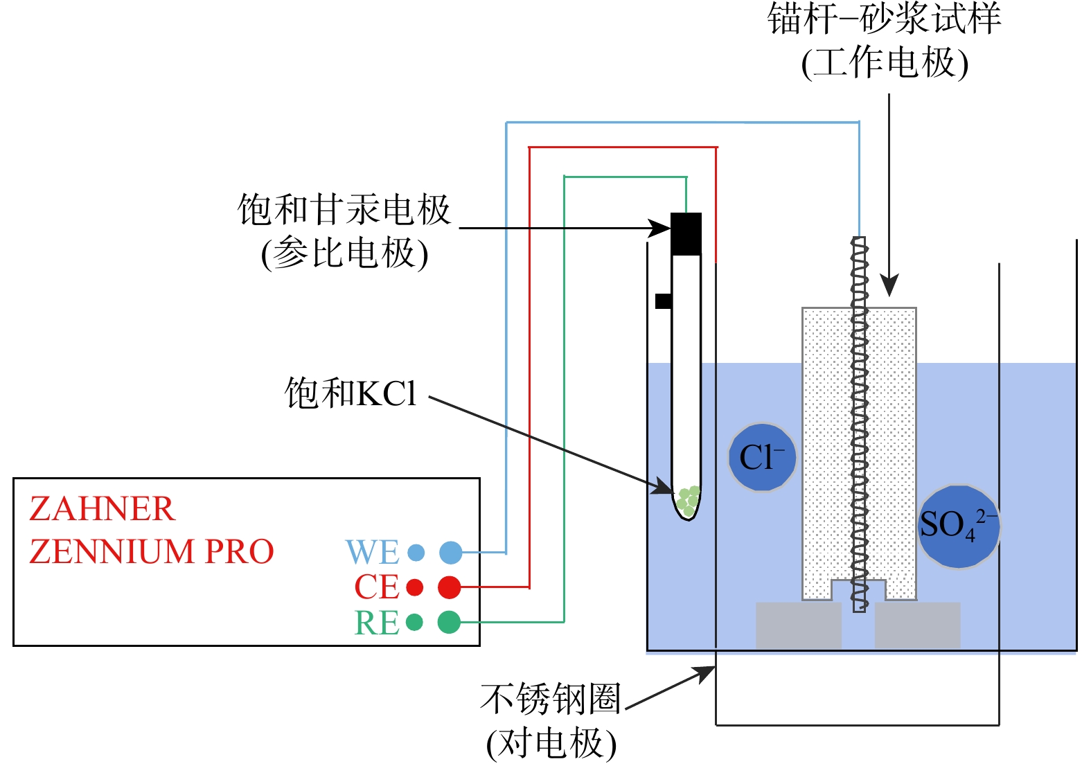
, Available online  , doi: 10.19509/j.cnki.dzkq.tb20240334
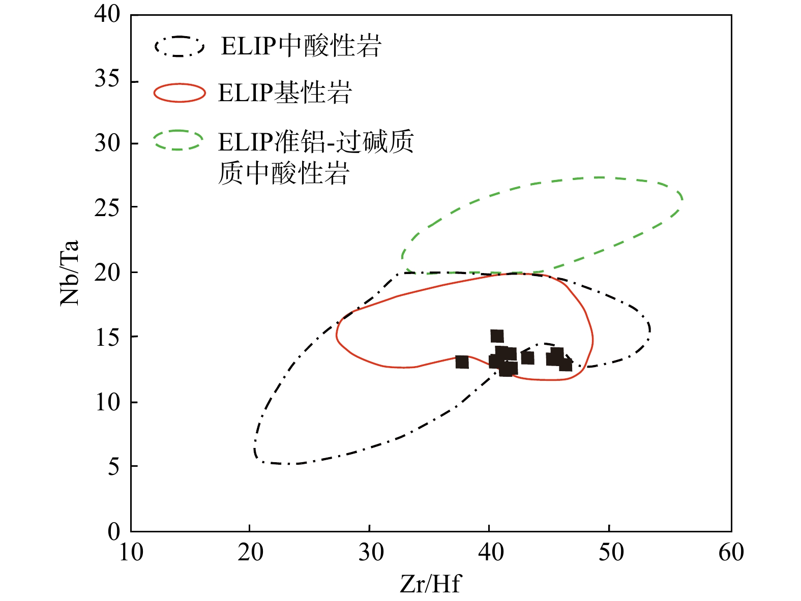
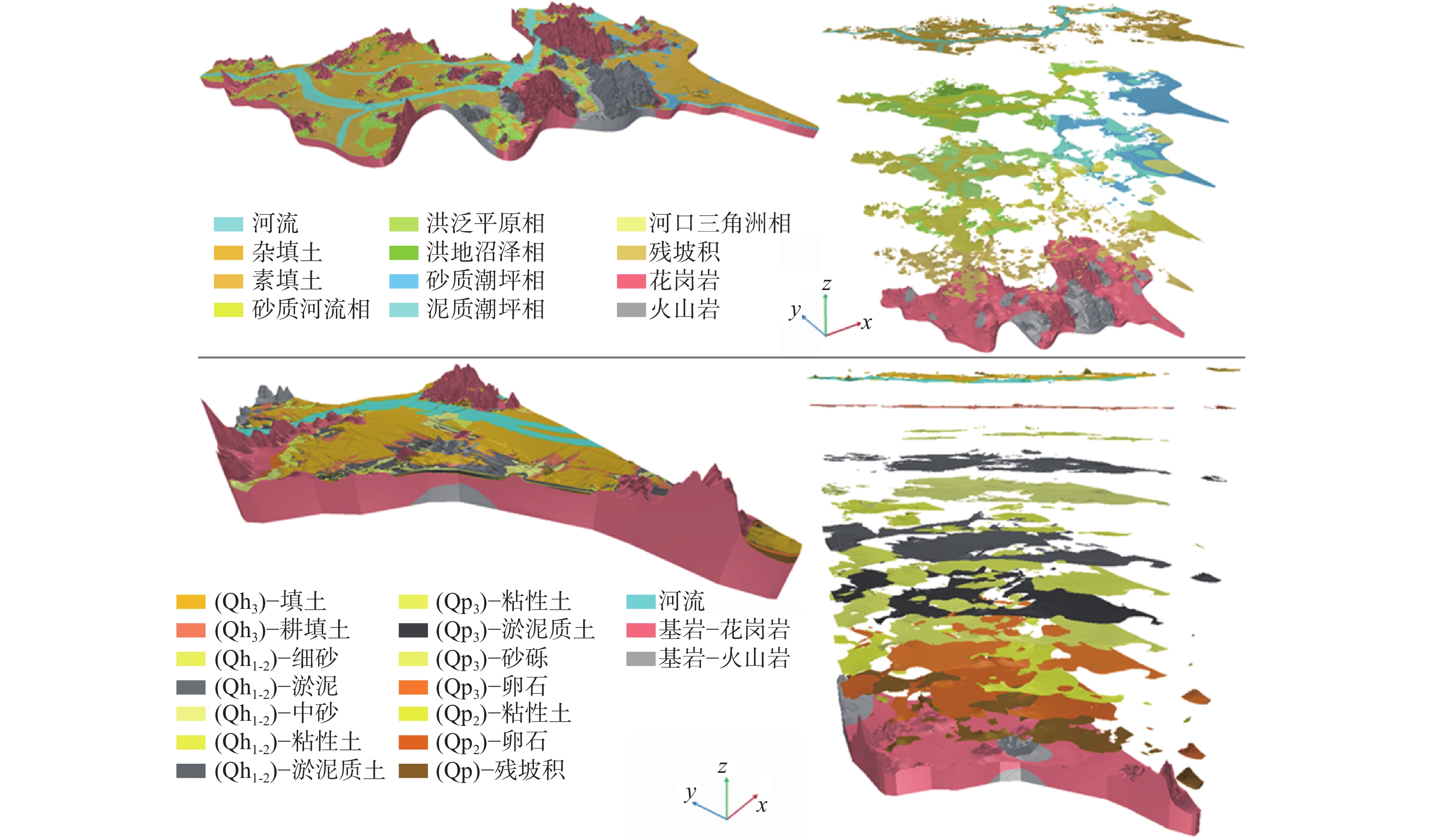
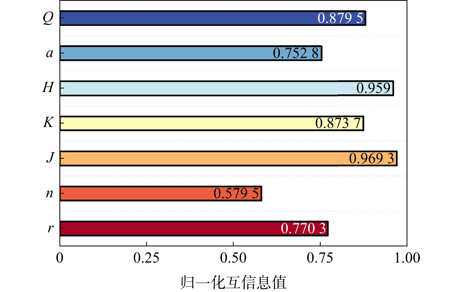
Abstract:
[Objective] Earthquakes pose a major threat to the safety of human life and the integrity of property, while they are also considered to be one of the main catalysts of various geological disasters. Given their potential impact, analysing and integrating information related to earthquake disaster has become an important task in supporting effective decision-making processes. However, earthquake disaster observation data are usually heterogeneous from multiple sources, which contain different scientific knowledge and low correlation between the data. This makes it difficult to use the information effectively for integration and querying. [Methods] A promising approach to these challenges is the use of the Semantic Web, of which the most exemplary approach is Knowledge Graph. Knowledge graph offer significant advantages in fusing and representing heterogeneous data from multiple platforms and disciplines. Considering the need for consistency between entity structures, while recognizing the diversity of information in the earthquake disaster domain, a structured approach was adopted. Firstly, a top-down approach was used to provide a systematic overview of concepts related to the earthquake disaster domain. This included the construction of a comprehensive ontology with several key components: earthquake disaster data, geological and geographic contexts, specific earthquake disaster events, emergency response tasks associated with these disasters, and models relevant to understanding and predicting earthquake behaviors. An earthquake disaster ontology layer was created. A bottom-up approach was adopted, aiming to create a high-quality data layer. In order to analyze the surface changes caused by earthquake activity before and after the disaster, a convolutional neural network was utilized to achieve a complex transformation from image data to structured textual knowledge based on remote sensing data. In addition, a fine-tuned Universal Information Extraction (UIE) pre-trained model was used. The model helps in recognizing named entities and extracting relational attributes from unstructured text data with extraction accuracies of 82.04% and 70.66% respectively. After the extraction phase, data fusion and unified representation is achieved by evaluating the semantic similarity of word vectors corresponding to the extracted entities and attributes. [Results] Taking the earthquake of 18 December 2023 in Jieshishan County, Linxia Prefecture, Gansu Province as an example, a high-quality earthquake disaster knowledge graph is formed through ontology construction, data extraction, and unified expression, and the transformation from multi-source heterogeneous seismic data of earthquake disaster to unified knowledge expression is achieved. [Conclusion] By building a knowledge graph of earthquake disaster, functions such as querying disaster loss data, providing decision support for the entire emergency response chain, and facilitating reasoning and querying about potential secondary hazards were realized. This reasoning capability is enhanced by integrating relevant geological data. The innovative approach presented in this paper utilizes deep learning techniques and pre-trained models to effectively fuse multimodal data and ultimately support the construction of an earthquake disaster knowledge graph, which helps to improve the ability to quickly and accurately query earthquake disaster information, thereby supporting proactive measures to respond to the occurrence of secondary disasters. This integrated approach not only facilitates immediate post-disaster analyses, but also lays the foundation for future advances in disaster management and response methods.
Hydrothermal Sandstone Geothermal Reservoir Evaluation of the Key Oil Area in the Songliao Basin
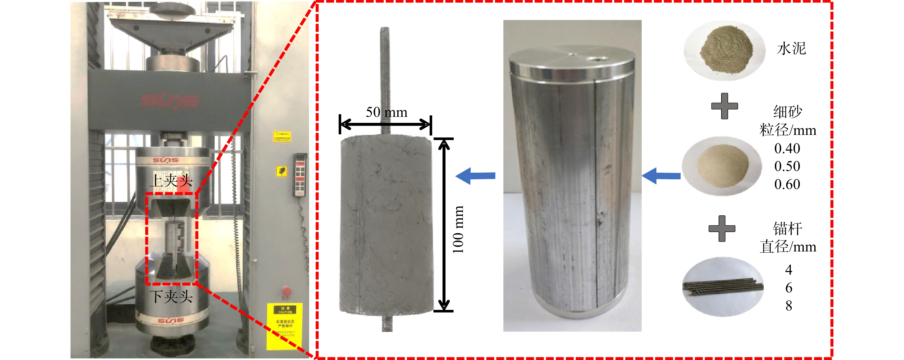
, Available online  , doi: 10.19509/j.cnki.dzkq.tb20240530
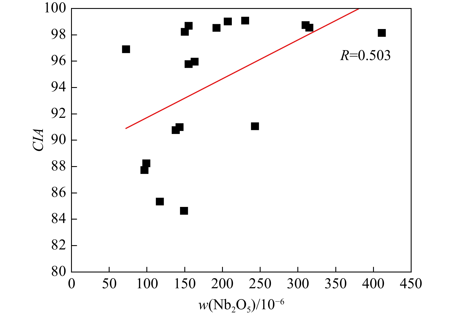
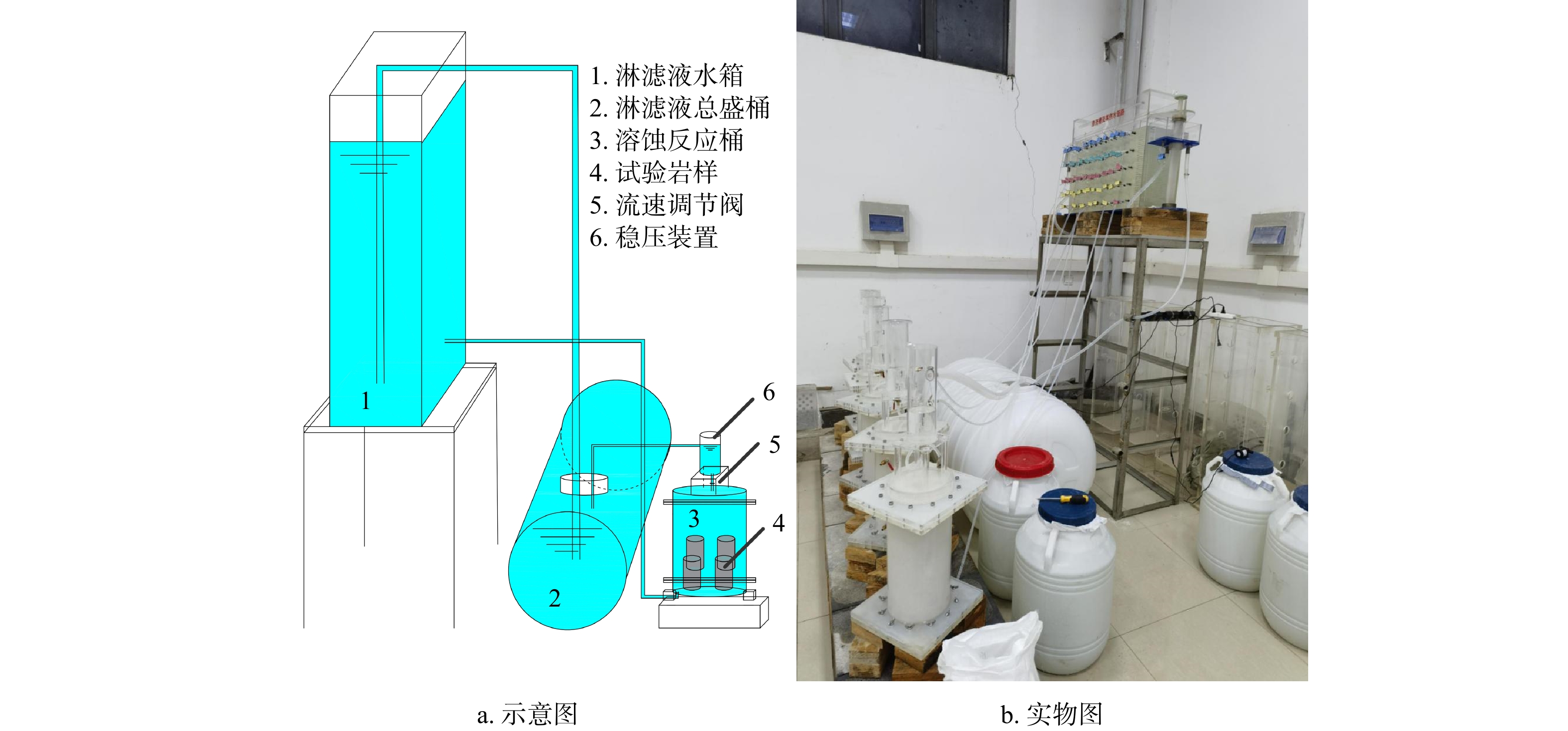
Abstract:
[Purpose] The current industry evaluation standards for geothermal reservoirs are formulated based on hydrothermal with excellent storage capacity (medium-high porosity and medium-high permeability). According to these standards, most of the geothermal reservoirs in China's basins are classified as hydrothermal reservoirs with poor storage capacity (characterized by medium-low porosity and low permeability), thus making the existing standards inapplicable. In addition, during the pre-feasibility exploration stage of geothermal resources, the commonly used evaluation methods require a large number of parameters and data. However, the information available at this stage is often limited. Therefore, it is necessary to explore rapid evaluation methods with fewer parameters. The hydrothermal sandstone reservoirs in the key oil areas of the Songliao Basin have the characteristics of medium-thin layers, medium-low porosity, and low permeability. They belong to hydrothermal with excellent storage capacity. Taking these as an example, this paper will study the evaluation standards of hydrothermal with poor storage capacity reservoirs and explore rapid evaluation methods for reservoirs under the condition of fewer parameters. [Methods] Firstly, based on understanding the basic characteristics of the thickness, porosity, and permeability of the target layer reservoir, statistical analysis was conducted. The golden section method was applied to classify the levels and determine the evaluation standards for these parameters. Secondly, since the temperature differences of the geothermal reservoirs are not significant and they all belong to low-temperature reservoirs, the daily production of a single well is more important for the evaluation of the geothermal reservoir. The thickness of the sand bodies, porosity, permeability, and daily production of a single well in the development area are selected. A multivariate linear regression analysis is used to analyze these data, construct a geothermal reservoir evaluation formula, calculate the scores of each evaluation unit, and divide the grades according to the golden section method. [Results] The score ranking of this method was compared pairwise with the score rankings of two existing evaluation methods. It was found that incorporating the thickness of the sand bodies while discarding temperature is reasonable. Moreover, the standard deviation of the scores obtained by this method is relatively large, which can better reflect the differences among the evaluation units. Therefore, this method is more feasible, and the evaluation criteria formulated for hydrothermal with poor storage capacity are more reasonable. [Significance] The evaluation criteria for hydrothermal with poor storage capacity determined in this paper have certain reference significance for the evaluation of geothermal reservoirs in other basins. Considering the differences between basins, the few-parameter rapid evaluation method determined in this paper may not be applicable to other basins. However, the process of determining the evaluation formula is worth learning from.
Suitability and potential evaluation of geological storage of carbon dioxide in saline aquifer of Ying-Qiong Basin
, Available online  , doi: 10.19509/j.cnki.dzkq.tb20240366
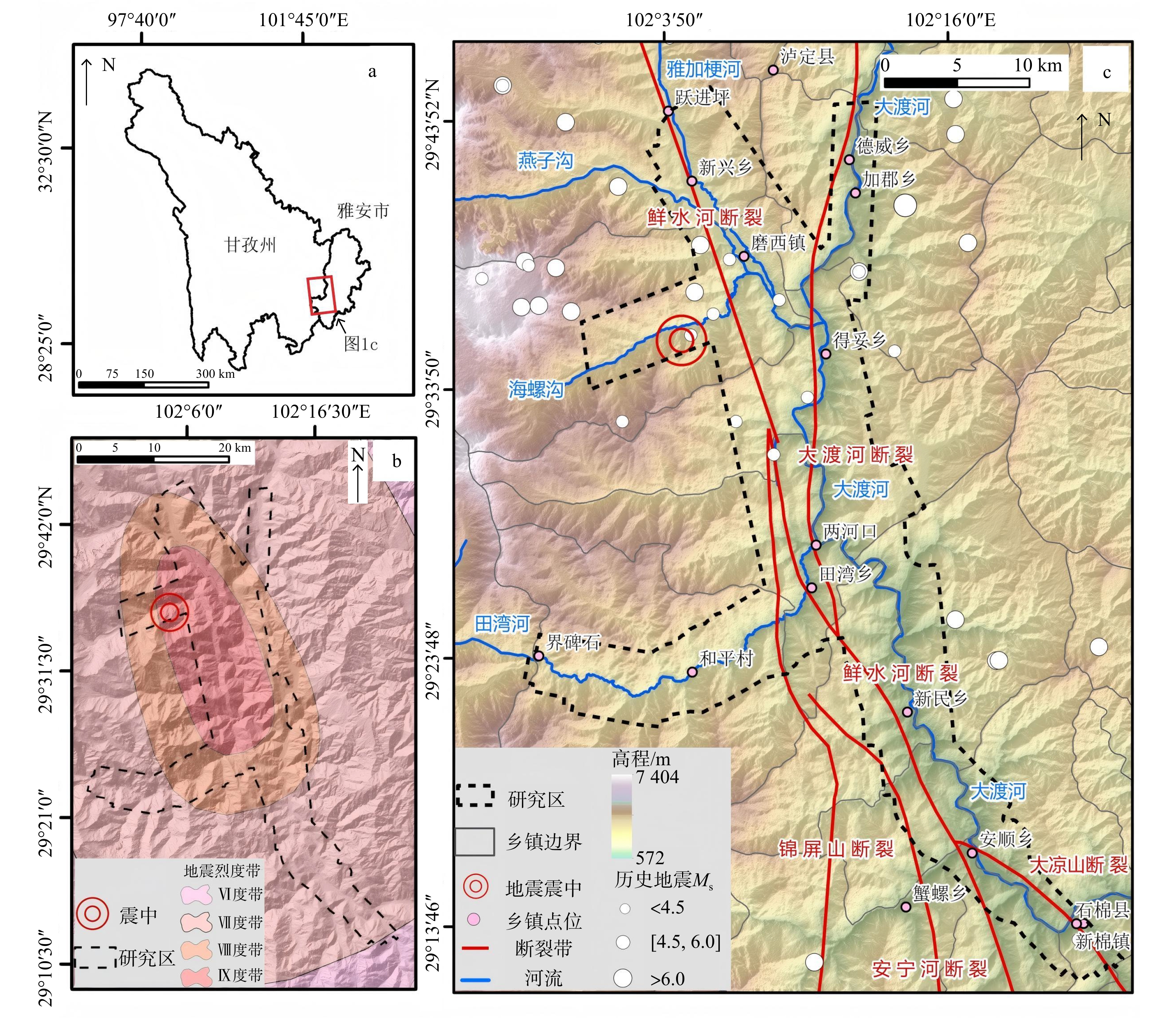
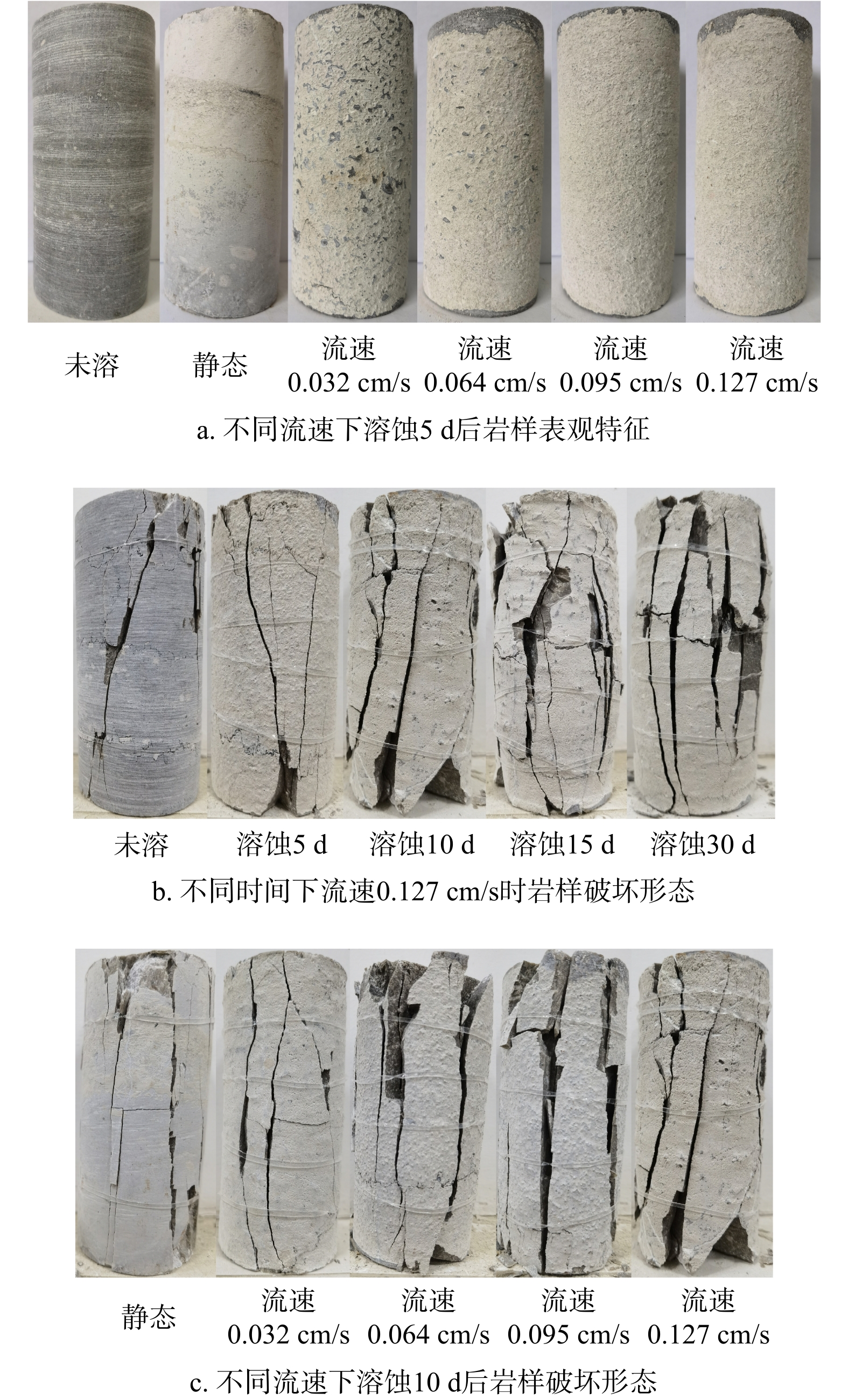
Abstract:

[Objective] Excessive carbon dioxide (CO2) emissions have caused global climate variability, leading to a series of environmental problems. As a key technology to reduce CO2 emissions, carbon capture, utilization, and storage (CCUS) plays an important role in relieving large-scale CO2 emission reductions, and the application of CO2 storage projects for the saline aquifer in offshore China has a broad application prospect and great technical and economic potential. [Methods] To address the problem of unclear understanding of the favorable areas and storage potential of CO2 in the saline aquifers in the Ying-Qiong Basin, the suitability evaluation of geological storage of CO2 is carried out by calculating the weights of the indicator components and the suitability score based on the geological characteristics of the Ying-Qiong Basin. In addition, the CO2 storage potential of the saline aquifer in the Ying-Qiong Basin is preliminarily evaluated by combining the effective CO2 storage coefficients calculated by the numerical simulation method and different storage potential calculation methods. [Results] Results show that the storage capacity obtained from EC method is less than that determined by the USDOE and CSLF methods. Since both of the CSLF methods consider the storage mechanisms such as geological structure storage, residual gas storage, and dissolution storage, the results seem more reasonable. [Conclusion] In summary, the CO2 storage potentials of the saline aquifer in the Yinggehai Basin and Qiongdongnan Basin are 7.96×10⁶ and 4.40×10⁶ million tons, respectively, and the total CO2 storage potential in the saline aquifer in the Ying-Qiong Basin is 1.24×10⁷ million tons, which further verifies the great potential of the industrial-scale pilot and demonstration projects of CO2 storage in the saline aquifer of the Ying-Qiong Basin and provides a good opportunity for the next step of carrying out the CO2 storage project in the saline aquifer of the Ying-Qiong Basin.

Research progress on trajectory control technology for geological core drilling
, Available online  , doi: 10.19509/j.cnki.dzkq.tb20240373
Abstract:
Geological core drilling is one of the important technical means for geological exploration, and the actual drilling trajectory of the borehole is an important parameter of drilling quality. It not only affects the safety inside the borehole during drilling construction, but also relates to the quality and accuracy of geological exploration. The limited conditions such as small bore diameter, low pipe strength and continuous geological coring which lead to difficult to control the drilling trajectory. Based on the analysis of the characteristics of geological core drilling, the trajectory control methods of geological core drilling were systematically sorted out, classified and summarized. The following research results are obtained. First, The primary goal of primary directional hole is to obtain the core of the target layer, analyzed the design method of parameters such as the inclination angle, orientation, displacement, etc. of the borehole and their variation with depth, and clarified the applicable conditions and drawbacks, provided ideas for the use of primary directional hole in drilling construction less than 500m, and pointed out that deep holes should be used in conjunction with other measures. Second, in terms of packed hole assemble for geological drilling, analyzed the usage of conventional hole assemble and large-diameter hole assemble, and proposed the mechanical theory of wire coring string with packed hole assembly.Third,around controlled directional drilling technology, analyzed the application in drilling deviation correction and lateral drilling obstacle avoidance, pointed out the advantages and disadvantages of different methods,indicating that small diameter bottomhole power drilling tools have obvious advantages. However, due to the requirements of geological coring technology, they have many limitations in geological core drilling.Through a review and analysis of the current status of geological core drilling trajectory control technology, clear identification of key factors affecting drilling trajectory and various techniques for controlling drilling trajectory, which can provide useful references and research ideas for improving the exploration accuracy of geological drilling.
Application of LithoScanner logs in recognition and evaluation of coaly source rocks
, Available online  , doi: 10.19509/j.cnki.dzkq.tb20240386
Abstract:
[Objective] In the Kuqa Depression, the Triassic and Jurassic periods feature five sets of source rock sequences that developed as alternating lake and swamp facies. Based on lithology, these sequences can be divided into coal, carbonaceous mudstone, and dark mudstone. The source rocks are characterized by high TOC abundance, significant thickness, and extensive distribution. Due to the multiple vertically distributed layers of source rocks and the strong heterogeneity in lithological distribution, conventional methods like the ΔlgR method have shown poor performance in TOC logging quantification. [Methods] To better understand the hydrocarbon resource potential and assess the reserves in the Kuqa Depression, this study first identified the lithological characteristics of the source rocks through core analysis. Further geological characterization of the source rocks was achieved via geochemical analysis data. Initially, the ΔlgR method was applied to quantitatively evaluate TOC logging, and LithoScanner logging was used for lithological identification of the source rocks. Further, LithoScanner logging was employed to achieve quantitative TOC logging evaluation. [Results] Overall, the Triassic and Jurassic periods are dominated by type II1, II2, and III organic matter, with medium to high maturity, and the quality of these source rocks ranges from medium to good. The method of using LithoScanner logging to identify different lithological source rocks and quantitatively evaluate TOC demonstrated significantly higher accuracy compared to the ΔlgR method. [Conclusion] The research findings provide valuable guidance for assessing the hydrocarbon resource potential in the Kuqa Depression and expand the application scope of LithoScanner logging data.
Research advances in the “end effect” of ore forming
, Available online  , doi: 10.19509/j.cnki.dzkq.tb20240387
Abstract:
As a front subject in the study of geology of ore deposits and geomechanics of ore fields, the “end effect” of ore forming has attracted more and more attention from experts and scholars. The research contents of the “end effect” of ore forming mainly include the “end effect” of ore-forming structures and that of ore-forming fluids: as for the former, the “end effect” of multi-scale ore-controlling structures in different tectonic settings as well as their role in controlling ore fields and ore deposits (bodies), especially the structural types, mechanical properties, and rock- and ore-controlling mechanisms of the “end” of deposit-level ore-controlling structures, the trapping effect of ore-forming fluids, and the location mechanism of ore deposits (bodies), is studied based on the structural analysis of geomechanics of ore fields and in combination with structure-(alteration) lithofacies mapping technique and geophysical probing technique; as for the latter, the characteristics of ore-forming fluids can be reflected through study of fluid inclusions and isotopes and the temporal and spatial evolution process of the “end” of ore-forming fluids can be finely depicted through study of zoning effect of the “end” of ore-forming fluids, thus revealing the restriction of physicochemical conditions of structures on ore-forming process. From the perspective of the coupling relationship between the “ends” of ore-forming structures and ore-forming fluids, an in-depth study can be made in the rock- and ore-controlling mechanisms under the “end effect” of structures and the genetic relation of structure-fluid coupled ore forming through close combination of study of geology of ore deposits and fluid geochemistry, structural analysis of ore fields, and geophysical prospecting technique, thus providing a basis for the prediction for deep ore prospecting.
Hydraulic Tomography in a Typical Basin-scale Aquifer of Groundwater Overexploitation Control in Hebei Province
, Available online  , doi: 10.19509/j.cnki.dzkq.tb20240709
Abstract:
One of the main challenges in characterizing the heterogeneity of large-scale aquifers using hydraulic tomography is to find an effective excitation that can significantly affect regional groundwater dynamics. Logically, variations of human-induced groundwater exploitation amounts may be a feasible option.This research selected the Handan Eastern Plain as the study area, one of the pilot areas for groundwater over-exploitation control in Hebei Province. Hydraulic tomography was applied to a two-dimensional confined aquifer by utilizing aquifer responses caused by reduced exploitation, and the effects of prior geological information and observation well configuration on parameter estimations were further discussed. Results showed that hydraulic tomography could effectively characterize the heterogeneity of large-scale aquifers, and accurate information of geological zonation could significantly improve parameter estimations. Correlation scales and variances have insignificant effects on the inversion results. In order to improve the precision of aquifer parameter estimation, the prior geological information and existing borehole data should be given full consideration, and new observation wells should be added into the existing monitoring network in the areas where there are significant changes in hydrogeological settings.This novel method for characterizing the heterogeneity of large-scale aquifers based on the concept of hydraulic tomography, is cost-effective for mapping large-scale aquifer heterogeneity with significant economic and social benefits, because it can save the huge time and manpower cost yielded by extra drilling and pumping tests by intelligently collecting the dataset of groundwater pumping and observation at the existing wells with reduced exploitation in the Hebei Province.
The Evolution of Continental Weathering and Upwelling in Early Silurian and the Implications for the Organic Matter Accumulations in the Shales of Longmxi Formation
, Available online  , doi: 10.19509/j.cnki.dzkq.tb20240678
Abstract:
Abstract: The organic-rich shales in the Early Silurian Longmaxi Formation are the important source rocks in South China, however, the deposition mechanism of these shales is still under debate. [Objective] In order to reconstruct the climatic and oceanic environments during the Early Silurian, and investigate the influence of significantly geological events (especially the continental weathering and upwelling) on the organic matter accumulation, [Methods] this study presents the geochemical compositions of the Lower Silurian succession of the Upper Yangtze Platform (BD1 core, Butuo district). [Results] The results show that the Longmaxi period experienced a transition from weak chemical weathering intensity in early period to intense chemical weathering intensity in later period. In addition, the Longmaxi Formation in studies area is characterized by restriction ocean. This study posits that early Longmxi sediments exhibited low chemical weathering intensity and more congruent weathering, while Aeronian sediments were characterized by intermediate chemical weathering intensity and incongruent weathering. Given that the gradual enrichment of oxygen within bottom waters can be supported by the redox condition proxies, this study suggests that congruent weathering-induced high paleoproductivity in early Longmaxi is the primary factor accelerating anoxia and further the enrichment of organic matter. [Conclusion] In summary, there is obvious differences between the deposition of Longmaxi shales in different areas, and this study suggests that the weathering-induced high productivity contributed to the deposition of organic-rich shales, while the upwelling likely triggered the organic matter accumulations in Longmaxi shales in the outer shelf, instead of inner shelf.
Fine characterization of the internal structure of typical fault-fracture reservoir outcrops in Xunyi area, Ordos Basin
, Available online  , doi: 10.19509/j.cnki.dzkq.tb20240522
Abstract:
[Objective] The fault-fracture reservoir in the southern Ordos Basin have large reserves, high oil abundance, and good development prospects. However, their internal structures are complex and varied, and the existing research results cannot support a detailed description of fault-fracture reservoirs. [Methods] In order to clarify the internal structural characteristics of the fault zones and construct a fine fault zone development model, this paper uses unmanned aerial vehicle oblique photography technology to conduct high-precision sampling and modeling of various typical fault-fracture reservoir outcrops in Xunyi area. We use self-developed software to collect and analyze three-dimensional data of the fault-fracture reservoir, and further study its internal structural characteristics and fracture development patterns. [Results]The results indicate that: (1) There are three types of fracture bodies developed in the Xunyi area: transtensional segment (half-negative flower pattern, graben pattern), pure strike-slip segment (closed translational pattern), and compression twisting (horst pattern); (2) Based on the comprehensive parameters such as the development of faults, rock morphology, and fracture development characteristics in the field outcrop, fault-fracture reservoir are divided into sliding breaking zones, induced fracture zones, and substrate zones. The structural patterns and quantitative rules of different types of fault-fracture reservoirs vary greatly, with only half-negative flower pattern and graben pattern fault-fracture reservoirs developing wide sliding breaking zones; (3) The fracture density is affected by the fault-fracture reservoir types,separation,fault spacing,block position,and sand layer thickness. Overall, the highest density is found in the graben type fault-fracture reservoir, followed by the half-negative flower patterned fault-fracture reservoir, and the lowest is found in the closed translational and horst type fault-fracture reservoirs; The larger the fault distance, the smaller the fault spacing, and the lower the rock thickness, the more developed the fracture; In the same fault-fracture reservoir, the density of fracture in different blocks shows different trends of variation. [Conclusion] This study identified four patterns and quantitative rules of fault-fracture reservoirs, summarized the influence of different factors on fracture density, and provided more accurate quantitative structural characteristics of fault-fracture reservoirs for underground reservoir characterization.
Simulation study on the effect of fault on COD migration in groundwater of landfill - A Case Study of Longhua Energy Ecological Park in Shenzhen
PEI Hongjun
, Available online  , doi: 10.19509/j.cnki.dzkq.tb20240731
Abstract:
Fault is an important channel for the migration and diffusion of groundwater flow and pollutants. However, there are few researches on the simulation of groundwater pollution migration of landfill by fault at home and abroad. [Objective]The purpose of this paper is to build a groundwater flow and solute transport model including fault permeability,[Methods] based on GMS software to simulate and predict the impact of characteristic pollutant seepage on groundwater environment and water delivery tunnel under different working conditions. [Conclusion]The simulation results show that under normal working conditions, due to the anti-seepage measures at the bottom of the plant, the diffusion range of pollutants is basically limited to the inside of the plant, and the maximum concentration of pollutants in the center is less than 0.5 mg/L. Under abnormal conditions, the pollutants in the leakage scenario of pollution source No. 1, No. 2 and No. 3 diffuse to the location of the water delivery tunnel on the 800th, 4015th and 1095 days, respectively. The vertical diffusion range of pollutants in the three simulated scenarios gradually increases, but there is little difference in the plane diffusion range. On this basis, i the simulation of groundwater pollution caused by the enhancement of the permeability of the fault zone is carried out. The results show that the enhancement of the permeability of F4 fault has a great environmental risk to the pollutant migration under the pollution source scenario No. 1 and No. 3. Under the No. 2 pollution source scenario, the enhanced permeability of F3 fault does not bring greater environmental risk to the tunnel area. The research in this paper can provide scientific support for groundwater pollution prevention and risk assessment in the study area.
Effects of inorganic salts on pore structure and permeability of undisturbed loess under dry and wet cycling conditions
LI Peiyue,HE Qiang,WU Jianhua,CHEN Yinfu,KOU Xiaomei,TIAN Yan
, Available online  , doi: 10.19509/j.cnki.dzkq.tb20240711
Abstract:
[Objective] The infiltration of inorganic salt solutions during dry and wet cycles exerts a significant influence on the structural strength and safety stability of loess masses. The aim of this research is to disclose the impact of inorganic salts on the pore structure and permeability of undisturbed loess under the effect of dry and wet cycles. [Methods] In order to fulfill this research objective, this study centered on the loess from the South Plateau in Jingyang County, Shaanxi Province. By employing laboratory experiments, this study systematically analyzed the variation law of the permeability and pore structure of undisturbed loess under diverse dry and wet cycling conditions and different concentrations of sodium chloride inorganic salt solution, as well as its mechanism of soil and water interaction. [Results] The findings indicated that dry and wet cycles diminished the permeability of undisturbed loess, and the saturated permeability coefficient of undisturbed loess decreased with the increment in the number of dry and wet cycles. The sodium chloride solution augmented the permeability of undisturbed loess, and the enhancement of permeability became more pronounced with the rise in the concentration of the sodium chloride infiltration solution. [Conclusion] Dry and wet cycles facilitated the development of fissures on the surface of undisturbed loess, augmenting the number and area ratio of micropores in the soil, thereby reducing the effective porosity of the soil mass and rendering the soil structure more compact. The infiltration of the sodium chloride solution promoted the dissolution of minerals such as gypsum and rock salt, leading to more developed soil pores and increased permeability. This study enriches the comprehension of the variation law of loess structure and permeability under the combined action of dry and wet cycles and inorganic salt solution infiltration, furnishing scientific support for soil and water conservation and engineering construction in loess regions.
Rapid seismic damage assessment of reservoir dams based on BO-GBDT
, Available online  , doi: 10.19509/j.cnki.dzkq.tb20240425
Abstract:
Reservoir dams are major lifeline projects, and how to quickly and effectively conduct seismic damage assessment of reservoir dams after an earthquake is of great significance for the development of rescue programs and post-disaster restoration. In order to quickly and accurately assess the damage status of reservoir dams that have been subjected to earthquakes., we select the details of the earthquake damage of each reservoir dam in Wenchuan 8.0 magnitude earthquake, and construct a sample dataset by combining the structural characteristics of the dams and the intensity of the earthquake. The missing values of the samples are processed using k-nearest neighbor interpolation, and the relevance of the sample features is judged. In this paper, we propose a rapid assessment model of earthquake damage of reservoir dams based on the gradient boosting tree algorithm.Four hyperparametric optimization methods, namely Grid Search (GS), Particle swarm optimization (PSO), Bayesian optimization (BO) and HyperBand Search (HS), are used for the Gradient Boosting Tree (GBDT) regression algorithm for parameter optimization, and the models were compared according to their performance metrics (coefficient of determination R2, root mean square error RMSE, mean error MAE) and ranked in terms of feature importance. The results show that the BO-GBDT model can assessment the degree of earthquake damage of reservoir dams with the shortest time consumption as well as higher accuracy, its regression coefficient R2 is as high as 0.98, and the characteristic importance score indicates that maximum crack width is the most influential factor. Comparison of the assessment results using this model with an earth dam earthquake damage assessment model based on an improved empirical statistical model showed further improvement in accuracy, which verified the reliability of the model in the application of rapid investigation and assessment of post-earthquake damage to reservoir dams.
Temporal and spatial evolution of layered subsidence in Hengshui City and its response mechanism to environmental factors
, Available online  , doi: 10.19509/j.cnki.dzkq.tb20240022
Abstract:
[Objective]Affected by climate change and human activities, the groundwater resources in Hengshui area are in an over-exploited state all year round, which directly leads to severe ground subsidence, which has become one of the main geological disaster problems in this region. [Methods]Based on the accumulated settlement data of the main urban area of Hengshui City from January 2009 to December 2022 obtained from layered monitoring, this paper analyzes and studies the ground subsidence mechanism of three compression layers (F1, F2, F3 layers from shallow to deep). Firstly, the Gompertz model is used to fit the cumulative settlement of each compression layer. The first-order derivative of the fitting results is obtained to obtain the settlement rate of each layer. With 0.5mm as the threshold, the settlement growth, rapid settlement rate growth, slow settlement rate decline and stable settlement period of each layer are obtained. Then, the zero growth (ZG) model is used to divide the settlement of each layer into irreversible settlement period (GRC) sequence and reversible rebound period (SWD) sequence, and analyze the fluctuation characteristics of settlement and rebound periods. Finally, the linear mixed model (LMM) is used to analyze the contribution of environmental factors such as precipitation, evapotranspiration, shallow groundwater level and deep groundwater level to the compression settlement (GRC_rate) during each layer's settlement period. [Result]The results show that: (1) The cumulative settlement fitting curves of each layer show an "S" shape, and the settlement rate curve shows a single peak pattern, with a "slow-fast-slow" trend. The main settlement period start time, end time, cumulative settlement and settlement rate of each layer are different; (2) In terms of cumulative settlement and monthly settlement increment amplitude, F3 layer>F2 layer>F1 layer. In terms of rebound amplitude, F1 layer>F2, F3 layer; (3) Evapotranspiration and shallow groundwater level contribute most to the compression settlement of F1 and F2 layers, while shallow groundwater level and deep groundwater level contribute most to the compression settlement of F3 layer.
Rock Image Lithology Recognition Method Based on Lightweight Convolutional Neural Network
, Available online  , doi: 10.19509/j.cnki.dzkq.tb20240348
Abstract:
【Objective】Lithology identification is a crucial step in the process of oil and gas exploration and development, providing important guidance for exploration positioning, reservoir evaluation, and the establishment of reservoir models. However, traditional manual lithology identification methods are time-consuming and labor-intensive. Although classical deep learning models achieve high identification accuracy, they often have a large number of parameters. To enhance model accuracy while reducing the number of parameters, the aim is to make the model suitable for real-time lithology identification.【Methods】This paper first collected a dataset of 3,016 rock images consisting of eight types, including dolomite and sandstone. Based on the lightweight convolutional neural network ShuffleNetV2, the paper proposes a Rock-ShuffleNetV2 lithology identification model (hereafter referred to as the RSHFNet model). The model incorporates the Convolutional Block Attention Module (CBAM) and Multi-Scale Feature Fusion Module (MSF) into the base network to enhance feature extraction capabilities and improve identification performance. Additionally, the number of stacked ShuffleNetV2 units is optimized to reduce the model's parameters.【Results】The experimental results show that the RSHFNet model achieved an accuracy of 87.21%, which is a 4.98% improvement over the baseline model. Furthermore, the model's parameters and floating-point operations were reduced to 8.69 × 10^6 and 9.3 × 10^7, respectively, representing 67% and 63% of the baseline model. This reduction significantly decreases the model's size. Additionally, the RSHFNet model demonstrates superior overall performance compared to existing convolutional neural networks.【Conclusion】The proposed RSHFNet lithology identification model offers high recognition accuracy and strong generalization capabilities while being more lightweight, providing a new approach for real-time lithology identification in the field.
Genesis of the Naneng gold deposit in southeastern Yunnan: Evidence from in-situ trace elements and isotopes of sulfides
, Available online  , doi: 10.19509/j.cnki.dzkq.tb20240520
Abstract:
[Objective] The Naneng gold deposit is an important medium-sized Carlin type gold deposit in southeastern Yunnan,and studying its genesis is of great significance for searching for such gold deposits in southeastern Yunnan. [Methods] Two generations of pyrite (PyI and PyII) were found to develop in the Naneng gold deposit during detailed field survey and indoor observation,and trace elements and sulfur isotopes of gold-bearing minerals are analyzed by LA-ICP-MS to constrain the source of ore-forming materials and ore genesis.[Results] LA-ICP-MS analyses show that PyI contains a small amount of Au (mean 6.37×10⁻⁶), which is relatively enriched in elements such as Co, Ni, Se, W; The distribution characteristics of trace elements in PyII and PyI are similar, but the content of Au (mean 68.02×10⁻⁶) is relatively high, and As, Sb, Cu elements are enriched in PyII; The average Au content of arsenopyrite is 36.02×10⁻⁶, and arsenopyrite is mainly enriched in elements such as As、Ni、Sb、Se、Au, while Zn, Ag, Hg and Tl elements are low. In addition, gold-bearing minerals in the Naneng gold deposit have consistent in situ δ34S values, ranging from 13.7‰ to 16.5‰, indicating that the S of gold-bearing minerals mainly come from the surrounding rocks.[Conclusion] It is preliminarily concluded that PyI was formed in a relatively stable environment by medium to low temperature hydrothermal fluid from the same source rich in trace elements such as Au、As、Sb, and a small amount of Au precipitated simultaneously with PyI in the form of solid solution (Au+). In the PyII stage, the intense tectonic activity in the area caused ore-forming fluid to upswell, and after sulfidation reaction with surrounding rock strata, the concentration of H2S in the fluid decreased, Au-HS complex became unstable, and Au supersaturated precipitation was enriched in PyII in the form of nanoscale inclusions (Au0).
Prediction model for rock elastic modulus based on TPE optimized ensemble learning
, Available online  , doi: 10.19509/j.cnki.dzkq.tb20240325
Abstract:
[Objective] Geophysical data is often used to determine the elastic modulus of formations in oil and gas engineering, with experimental data from small sample cores used for calibration. However, acquiring core samples from every stratum is impractical, which often leads to this method's inadequate performance in complex geological settings. To improve the predictive accuracy and generalizability of rock elastic modulus, an intelligent prediction model based on fundamental rock physical properties has been introduced. [Methods] Using 397 sets of core experimental data from diverse sources, with compressional wave velocity and shear wave velocity and density as input variables, intelligent prediction models for rock elastic modulus were developed based on three ensemble learning algorithms (RandomForest, XGBoost, LightGBM), the TPE method was employed to optimize the models. The dynamic elastic modulus and static elastic modulus regression model was constructed according to the methods currently used in petroleum engineering was used to provide a comprehensive assessment of the performance of the intelligent predictive model using statistical indicators. Additionally, the SHAP method was utilized to assess the contribution of each input variable to the model. [Results]The research findings indicate that: (1) The ensemble learning model optimized using TPE is significantly better than traditional statistical regression models, and can achieve accurate prediction of elastic modulus without distinguishing geological layers, with strong generalization ability. Among them, the XGBoost model performs the best (R2=0.87, RMSE=6.94,MAE=4.96). (2) Shear wave velocity makes the greatest contribution to the model, followed by compressional wave velocity, with density having the least impact. Accurate shear wave velocity is crucial for predicting elastic modulus. [Conclusion] This method allows for the precise prediction of elastic modulus without the need for prior identification of the work area and strata, providing valuable insights for the design and implementation of oil and gas engineering projects.
In situ pH measurement and prediction modelling of the impure CO2-water system under high temperature and pressure conditions
, Available online  , doi: 10.19509/j.cnki.dzkq.tb20240421
Abstract:
[Objective] The injection of gases containing CO? into deep aquifers will dissolve to form carbonic acid, leading to a reduction in the pH value of the aquifer. This, in turn, will cause metal corrosion of pipelines and dissolution or precipitation of minerals, which will have an impact on the safety and efficacy of CO? geological utilisation and storage. The combination of experimental measurements of the pH of pure/impure CO? saturated solution systems with model predictions allows for the assessment of chemical changes under conditions of CO? geological sequestration. [Methods] In this study, the pH of pure CO?-water systems and impure CO?-water systems were measured under in situ conditions using potential and spectroscopic methods at temperatures between 35 and 93°C and pressures between 0.38 and 18 MPa. A chemical equilibrium model based on solubility calibration was then established to calculate and predict the pH values of pure/impure CO?–water systems for evaluation purposes. [Results] The findings indicate that N? and CH? exerts a detrimental impact on the CO?-saturated system, resulting in the reduction of CO? solubility in water and the subsequent elevation in pH. Notably, the influence exerted by CH? is more pronounced than N?. The model demonstrats superior performance in predicting the pH of the pure CO2-water system, with a maximum deviation of only 0.05 pH. However, in the impure CO2-water system, some deviation is observed, particularly at 50°C and a CO2-impurity gas ratio of 1:9, with a maximum deviation of 0.15 pH. [Conclusion] The findings of this study offer valuable insights into the chemical changes associated with impure CO2 injection into the formation, which is crucial for enhancing the safety and efficacy of carbon sequestration.
Sedimentary structure characteristics and logging identification method for the first member of Qingshankou Formation shale strata in Gulong sag
, Available online  , doi: 10.19509/j.cnki.dzkq.tb20240641
Abstract:
[Objective] The fine classification and quantitative characterization of sedimentary structure types is a crucial issue in the exploration and development of shale oil. [Methods] To this end, taking the continental shale strata of the first member of Qingshankou Formation (K2qn1) in Gulong sag of Songliao Basin as an example, based on core and thin section observations, whole-rock mineral X-ray diffraction and electrical imaging logging data, the sedimentary structure characteristics under lithological differences were clarified, and a quantitative logging identification method for sedimentary structures applicable to continental shale strata was established. [Results] The result shows that the differences in sedimentary structure characteristics under different lithologies of K2qn1 shale strata are mainly reflected in the mineral composition of the laminae and the thickness variation of the bedding (texture). The sedimentary structure types can be divided into laminar (single layer ≤1 cm), lamellar (1 cm < single layer < 10 cm), and massive (single layer ≥ 10 cm) based on the size of the single-layer thickness. Relying on the high resolution advantage of electrical imaging logging slice image, the layer interface in electrical imaging slice is identified by edge detection and Hough transform, and the sedimentary structure type is quantitatively divided based on the thickness of the layer interface. This method not only overcomes the problem of insufficient characterization accuracy of millimeter-scale laminae in traditional dynamic and static imaging logging images, but also compensates for the drawback that the previous use of laminae density cannot effectively divide the lamellar and laminar sedimentary structures within the logging unit window length. [Conclusion] Overall, the sedimentary structure logging identification method based on electrical imaging slices proposed in this paper has high accuracy and good generalization, which can provide strong support for the subsequent continental shale reservoir effectiveness evaluation.
Quantitative characterization and simulation of soil moisture distribution in heterogeneous vadose zone
, Available online  , doi: 10.19509/j.cnki.dzkq.tb20240256
Abstract:
Abstract::[Objective] The vadose zone, as a crucial linkage between vegetation and groundwater, plays a significant role in influencing groundwater ecological functions. Among the various factors, lithological structure stands out as one of the primary factors affecting groundwater ecological functions. In order to investigate how the lithological structure of the vadose zone influences soil moisture distribution, [Methods] laboratory experiments were conducted on layered heterogeneous soil columns to investigate water release and infiltration. The distribution patterns of water movement during soil moisture infiltration, particularly the formation mechanism and distribution of capillary fringe above the fine-grained soil layer, were analyzed. Additionally, a comparative analysis was performed on the coupling of three commonly used Soil Water Characteristic Curve (SWCC) models with the Richards model. Based on this analysis, modifications were made to the simulation methods to better simulate water distribution in layered heterogeneous soils. [Results] During the experiment, the fine-grained soil interlayer structure causes water retention in the interlayer and at the upper and lower interfaces of the interlayer, forming a water accumulation area. Compared with column O, the water release duration of column A, column B and column C increased by 290h, 500h and 780h, respectively, and the water holding capacity increased by 6.20cm, 7.90cm and 7.83cm, respectively. The water retention in the interlayer of column A, column B and column C and at the interlayer interface accounted for 24.50%, 33.09%, 45.77% and 3.19%, 5.01% and 11.38% of the total water retention, respectively. The numerical simulation results show that the modified van Genuchten model can better simulate the layered soil moisture profile. [Conclusion] Fine-grained soil interlayer has a significant retarding effect on the underwater migration characteristics of infiltration, and water is mainly retained inside the interlayer and at the upper and lower interfaces of the interlayer. The increase in the thickness and number of interlayers will lead to more water retention inside the interlayer and at the interlayer interface. The corresponding relative permeability equation is divided into three stages, which can effectively improve the simulation accuracy of layered soil water content profile.
Frontiers and Potential Directions of International Deep Earth Exploration
, Available online  , doi: 10.19509/j.cnki.dzkq.tb20240456
Abstract:
【Objective/Significance】Deep Earth exploration is a multidisciplinary and complex endeavor to understand the structure, dynamics and evolution of continents and their margins. It is in the common interest of human society to study the Earth's interior and gain a deeper understanding of how it works. Since the development of deep Earth exploration for half a century, many countries worldwide have carried out a series of programs, and have accumulated rich experience and achievements while making significant breakthroughs in technology and methods, which has important reference significance for deep Earth exploration in China.【Analysis/Discussion/Progress】This paper analyzes the technical means and achievements adopted by the representative deep Earth exploration programs in the United States, Europe, Australia since the 21st century, and summarizes the latest progress of these programs. 【Conclusion/Prospect】Six frontiers and key potential directions of deep Earth exploration were summarized, including seismic tomography for deep Earth structure detection, magnetotellurics for mineral resource exploration, GNSS monitoring for Earth's motion and state changes, coupled surface to deep Earth processes, advanced data processing, analysis and modeling capabilities, and open data sharing. It is expected to provide information support and references for “SinoProbe-Ⅱ” deep exploration program, “Earth CT” international cooperative research program, and National Science and Technology Major Projects of deep Earth and mineral resources exploration in China.
The identification of active landslides and analysis of deformation influencing factors in the Baihetan Reservoir area
, Available online  , doi: 10.19509/j.cnki.dzkq.tb20240351
Abstract:
Reservoir landslides are a common geological hazard in hydropower engineering construction. When landslides slide into the reservoir area, they may cause surges, river blockages, and even dam breaches, resulting in significant economic losses and casualties. Therefore, studying the deformation characteristics of reservoir landslides is crucial for efficient and timely identification and monitoring of early-stage landslides along the reservoir area. [Methods]In this paper, the Baihetan Reservoir area is taken as the study area. Based on Sentinel-1 radar images, broad-scale active landslide disaster identification and deformation information before and after the reservoir filling of landslides in the Baihetan Reservoir area are obtained using Stacking Interferometry Synthetic Aperture Radar (Stacking-InSAR) and Small Baseline Subset Interferometry Synthetic Aperture Radar (SBAS-InSAR) methods. Combined with Sentinel-2 images, Automated Water Extraction Index (AWEI) is used to extract reservoir water level data. One typical landslide with significant deformation of each type—ascending, descending, and pre-filling deformation—was selected to investigate the relationship between reservoir water level fluctuations, rainfall, and landslide deformation. [Results and Conclusion] The study concludes that: The method of extracting reservoir water level data using AWEI with Sentinel-2 imagery has shown good results in this study area. The average error between the extracted water level and the measured water level at the same time is 0.89 meters. This method has research value for areas lacking water level data.During the observation period, a total of 103 active landslides were detected in the Baihetan Reservoir area using both ascending and descending orbit images. Among these, 37 active landslides involved the front edge entering the water, and 23 landslides were deformed due to water level fluctuations. There is a strong correlation between reservoir bank landslide deformation and water level fluctuations, while the correlation with rainfall is weaker, and the decrease in water level has a greater impact on reservoir bank landslide deformation.
, Available online  , doi: 10.19509/j.cnki.dzkq.tb20240208
Abstract:
Application of machine learning models to geothermal groundwater temperature prediction
, Available online  , doi: 10.19509/j.cnki.dzkq.tb20240063
Abstract:
Geothermal energy as a kind of clean energy has broad application prospects. The temperature assessment of geothermal water in sustainable development and utilization of geothermal resources is an important research topic. Artificial intelligence technology has become a hot spot and frontier direction in the exploration and development of mineral and oil and gas fields, but in the field of geothermal field development, there are few relevant studies. This paper first analyzes the important value of large data and artificial intelligence application in oil and gas field development, and then introduces the application of artificial intelligence in geothermal field development at present. Taking Xianyang geothermal field in Shaanxi province as an example, the single well geothermal water temperature time series model was constructed by using long and short term memory neural network (LSTM) under the predestined production mode. Random forest and XGBoost algorithm were used to predict the groundwater temperature of multiple geothermal wells. The accuracy of the three models was above 95%, and the running speed is fast. The depth at the top of the water intake section is the primary influencing factor of geothermal water temperature in this area. The model verifies that the fault zone plays an important role in heat storage.The application of the example verifies the superiority of machine learning in solving complex problems in geothermal field development, and the reasonable application of artificial intelligence technology can provide more effective decision-making basis for the efficient development of geothermal field and scientific cost reduction, quality improvement and efficiency improvement.
A Study on Defining the Evolution Stage of Sealing Properties of Fault Zone Filling materials ——Taking the F3 Fault in K1d1 of Beier Depression as an Example
, Available online  , doi: 10.19509/j.cnki.dzkq.tb20240302
Abstract:
[Objective] The unreasonable division of the evolution stages of the sealing ability of fault zone filling materials makes it impossible to reasonably explain the differences in oil and gas distribution in different parts of fault traps. [Methods] To solve this problem, in this paper, a research method is established to evaluate and evolve the Closure Index and Cement Index for the fault zone filling material and underlying reservoir rock, and then to comprehensively determine the evolutionary stage of sealing for fault zone filling material by comparing the relative size of the the Closure Index and Cement Index between the fault zone filling materials and underlying reservoir rocks over time. [Results] The method was used to determine the evolutionary stage of sealing of the F3 fault zone filling material in K1d1 of Huhenuoren tectonic belt, Beier Depression, Hailar Basin. The results show that: the fault zone filling materials of the F3 fault in K1d1 are in the stage of non-Closure Sealing and non-Cement Sealing at the measurement points 2,4, 6, 9-11, which is not conducive to the accumulation and preservation of oil and gas in K1n2, resulting in no oil and gas display obtained during oil and gas drilling. The fault zone filling materials of the F3 fault in K1d1 at measurement points 1, 3, 5 are in the stage of Closure Sealing at present. However, due to their evolutionary stage of non-Closure Sealing and non-Cement Sealing during the critical period of reservoir formation, no oil and gas was obtained during oil and gas drilling too. The fault zone filling materials of the F3 fault in K1d1 at measurement points 7、8、12-15 are in the stage of Closure sealing and Cement Sealing, which is most conducive to the accumulation and preservation of oil and gas in K1n2. There are oil and gas accumulation at measurement points 7-8 and 12-15 from oil and gas drilling. [Conclusion] Therefore, the method of determining the evolution stage of fault zone filling material sealing ability is feasible, which is of great significance for determining the sealing ability and formation time of fault traps, and improving the efficiency of oil and gas exploration.
Development Status and Trend Analysis of Physical Simulation Experiments for Geological Hazards
, Available online  , doi: 10.19509/j.cnki.dzkq.tb20240454
Abstract:
[Significance] In the past 20 years, physical simulation experiments of geological hazards have developed rapidly, forming an interdisciplinary, widely applied, and rapidly updated development status. Analyzing the current status and trends of physical simulation experiments for geological hazards can help researchers in related fields grasp the industry's current situation, design experiments, develop equipment, and update technologies based on development trends, providing rich and reliable experimental and data for theoretical innovations in geological hazards. [Progress] The paper has conducted extensive research on literature related to physical simulation experiments of geological hazards, and summarized five significances of conducting physical simulation experiments of geological hazards. Then, the research status of the six technologies for geological hazard simulation experiments is analyzed. Model box and flume simulation technology have the characteristics of diverse combinations, low prices, easy installation, and simple operation, and are the most widely used physical simulation technologies for geological hazards. The base friction technology achieves coupling between the simulation model and the gravity field at a low cost, but simulation experiments can only be conducted on two-dimensional slope models. Shaking table and centrifuge simulation technology have high construction and usage costs, but due to their ability to provide vibration and gravity environments for the experimental process, these two technologies are still irreplaceable in geological hazard physics simulation experiments. In situ simulation technology has the drawbacks of long experimental cycles, difficult model production, high personnel input, low automation level, and poor repeatability, but it has significant advantages in avoiding scaling effects, boundary effects, and gravity distortion. [Conclusions and Prospect] The physical simulation experiments for geological hazards are developing towards complex scene construction, large-scale experiments, scientific material selection, and intelligent data collection. This puts higher requirements on experimental technology and economic costs, and there is an urgent need to create a favorable development environment for physical simulation experiments of geological hazards so that physical simulation technology can play a greater role in geological hazard research.
Susceptibility Evaluation of Debris Flows in Gansu Province Based on LA-GraphCAN
, Available online  , doi: 10.19509/j.cnki.dzkq.tb20240324
Abstract:
[Objective]The current research on the susceptibility of debris flow disasters has yet to address the limitations of geographic location relationships and spatial dependence. [Methods]This article constructs a debris flow dataset for Gansu Province with 10,198 sample points and proposes a susceptibility assessment method based on LA-GraphCAN. Initially, a nearest neighbor graph is built using KNN based on the cprojection coordinates of sample points. Secondly, GCN is used to efficiently aggregate local neighborhood information and extract key geographic and environmental features. Additionally, GAT is introduced to add a dynamic attention mechanism, enhancing the representation of features. Then ,validate the effectiveness of the proposed method, conduct comparative analyses from different perspectives, and finally, evaluate the susceptibility of debris flows in Gansu Province. [Results]The results indicate that LA-GraphCAN achieves accuracy, precision, recall, and F1 scores of 0.9441, 0.9287, 0.9375, and 0.9331, respectively, outperforming mainstream machine learning models such as Random Forests and CNN. Based on the evaluation of LA-GraphCAN, the number of historical debris flow disaster points in the highly susceptible areas of Gansu Province is 4055, accounting for 95% of the historical debris flow occurrences in Gansu Province, which is consistent with the distribution of historical disasters. [Conclusion]Both the performance evaluation and the susceptibility assessment results for Gansu Province indicate that the LA-GraphCAN method, which considers the spatial dependencies of debris flow disasters, yields superior results and is well-suited for debris flow susceptibility research.
Research progress on formation mechanism and reservoir control of Strike-slip Fault-karst oil reservoir
, Available online  , doi: 10.19509/j.cnki.dzkq.tb20240149
Abstract:
[Significance] Fault-karst reservoir is widely developed in most basins in China, and its resources are huge, which has become a new hot topic in the field of geography. However, due to the deep burial and difficult exploration of fault-karst reservoir, and it is urgent to form a consensus understanding of trap division, formation mechanism and development control factors. [Progress and Conclusions] Based on literature research, this paper deeply discusses the formation mechanism of fault-karst reservoir. Fault-karst reservoir is a kind of fracture-vuggy reservoir formed in carbonate strata by karstification under the influence of multi-stage tectonic activities. Firstly, the basic concept of Fault-karst reservoir is reviewed. It is pointed out that fault-karst reservoir has the characteristics of deep burial, strong heterogeneity and large difference of fluid properties, and the important role of strike-slip fault in hydrocarbon accumulation and migration is emphasized. Based on the analysis of geological data in Shunbei area and other areas of Tarim Basin, this paper reveals the trap types, formation mechanisms and reservoir-controlling factors of fault-karst reservoir. It is concluded that the segmentation of strike-slip faults, the activity of solution fluid and the timely emplacement of hydrocarbons are crucial to the development of fault-karst reservoir. What's more, the roles of atmospheric fresh water, hydrothermal fluids and hydrocarbon fluids in reservoir reconstruction are also discussed, and how they jointly affect the formation and distribution of Fault-karst reservoir. At last, the paper summarizes the reservoir-forming models of fault-karst reservoir. [Prospects] The discovery and understanding of fault-karst oil reservoir have opened up a new field and direction of oil and gas exploration.
Characteristics of Change in Annual Runoff Volume of Karez in the Turpan Basin in Recent 30 Years
, Available online  , doi: 10.19509/j.cnki.dzkq.tb20240094
Abstract:
Karez is an important water conservancy facility in the Turpan Basin.The purpose of this paper is to alleviate the decreasing status of karez , analysing the changing characteristics of annual runoff volume of karez in recent 30 years, which is of great significance for agricultural irrigation, cultural heritage preservation, tourism development and so on. Based on the discontinuous 13 years of annual runoff volume of karez in the study area for the period 1990—2022, as well as year-by-year the exploitation amount of electro-mechanical wells, and water supply from surface water sources, statistical analyses were performed using SPSS 20 software to interpolate missing measurements, and use the trend and mutation analyses to determine their change curves and mutation years. The results of the study indicate: between 1949 and 2023 the number of karez reduced from 1084 to 169,implying that an average of 16 karezs dried up or disappeared each year, while the flow rate declined from 16.11 m3/s to 3.6 m3/s. The correlation coefficients between the annual runoff volume of karez and the exploitation amount of electro-mechanical wells, the amount of water supplied by surface water sources, the irrigated area and precipitation were -0.890, -0.149, -0.660, and 0.764. Through the construction of a model of the relationship between the annual runoff volume of karez and the exploitation amount of electro-mechanical wells and the amount of water supply from surface water sources, and the average relative error between the measured value and the predicted value was 1.8%, which effectively solved the problem of missing data. In addition, the exploitation amount of electro-mechanical wells and the amount of water supplied by surface water sources as a whole showed a fluctuating upward trend, and the annual runoff volume of the karez increased and changed abruptly in 2006, the reasons for the sudden change might be related to the government's implementation of regulations for the protection of karez. Therefore,in view of the important cultural and engineering value of karez , make greater efforts in the future to protect it and promote the sustainable use of water resources and high-quality development in the Turpan Basin.
Characteristics of oil shale development and paleoenvironment restoration of Jurassic Yan’an Formation in southwestern Ordos Basin
, Available online  , doi: 10.19509/j.cnki.dzkq.tb20240171
Abstract:
[Objective]There are many sets of oil shale associated with coal and non-associated oil shale in the Jurassic Yan’an formation in the southwest of Ordos Basin, but the study on the characteristics and sedimentary environment of oil shale in this area has been relatively lacking for a long time. [Methods]Based on the oil shale samples from wells in the study area, the industrial index, geochemistry characteristics and sedimentary paleoenvironment of oil shale were studied by low-temperature retorting, rock pyrolysis, major and trace elements measurement and gas chromatography. [Results]The oil shale in study area oil-bearing ratio is 3.8% ~ 6.7%, the ash is 49.46% ~ 75.58%, the total sulfur is 0.31% ~ 2.29%, and the calorific value is 11.95 kJ/g (average value). The logging curves show the characteristics of high gamma, high resistivity and low natural potential, which is obviously different from coal bed and mudstone. The main type of organic matter was II2. The abundance of organic matter is high, and the whole is in the stage of immature-low maturity. It belongs to middle quality, siliceous ash and extra low sulfur oil shale. The main elements in the oil shale are SiO2 and Al2O3, which are 48.26% (average) and 17.57% (average) and the micronutrient Sr, Th, and U were enriched, and Ni, V, and Ba were depleted, indicating that there were more potassium-containing minerals and higher stable components in the study area. [Conclusion]Based on the analysis of paleoenvironmental element markers and saturated hydrocarbon chromatography, it is considered that the organic matter mainly comes from the mixed organic matter, ancient productivity is medium and the sedimentary environment is unique, which belongs to the warm and humid continental fresh water depression environment. The analysis of environmental factors shows that the redox condition is the main influencing factor of organic matter enrichment and the sedimentary model of oil shale evolution in Yan’an formation in different depositional periods is established. The research results provide important theoretical guidance and technical support for the oil shale exploration and development of the Jurassic Yan’an formation in the southwestern margin of Ordos Basin.
Pressure evolution and weak low pressure genesis of Shanxi Formation sandstone reservoir in Xinzhao area, northern Ordos Basin
, Available online  , doi: 10.19509/j.cnki.dzkq.tb20240130
Abstract:
The Upper Paleozoic sandstone reservoirs in Xinzhao area, northern Ordos Basin are rich in natural gas and generally develop abnormal low pressure. The understanding of paleo-pressure evolution and current subnormal pressure formation mechanism is not very clear, which constraine the understanding of tight sandstone gas accumulation and increase of natural gas reservoir and production. In this paper, the petroleum charging history in the second member of Shanxi Formation was comprehensively analyzed by means of fluid inclusion petrographic observation, micrometry and laser Raman analysis, and the paleo-pressure in the key period of reservoir formation was obtained. The paleo-pressure evolution history was recovered by basin simulation method, and the coupling relationship between paleo-fluid pressure evolution and petroleum charging was established. The relationship between the causes of subnormal pressure and tight gas accumulation is further discussed. The results show that: (1) CO2 was captured in the second member of Shanxi Formation in Xinzhao area from 170 to 180Ma, when the source rock was in the middle to low maturity stage, and the methane inclusion was captured in the peak of hydrocarbon generation from 138 to 121Ma. (2) The overpressure in the second member of Shanxi Formation began to develop in the early Jurassic, and reached the maximum in the end of the Early Cretaceous. The paleo-pressure and paleo-pressure coefficient were about 50MPa and 1.31 respectively. (3) Due to temperature decrease, pore rebound and gas diffusion, the decrease of formation pressure in the second member of Shanxi Formation accounted for 49%, 14.5% and 36.5% of the total formation pressure, respectively. The tight gas reservoir of the second member in Shanxi Formation has undergone the evolution process of normal pressure-medium overpressure-normal pressure and low pressure. Hydrocarbon generation supercharging and pressure conduction are the main reasons for the formation of ancient overpressure. Temperature drop and natural gas diffusion are the main factors for the formation of abnormal low pressure in the second member of Shanxi Formation.
Provenance Analysis of Benxi Formation in Yanchang Exploration Area of Ordos Basin
, Available online  , doi: 10.19509/j.cnki.dzkq.tb20240191
Abstract:
The source of detrital material is one of the important factors controlling the development and distribution of the Benxi Formation sandstone reservoir in the Yanchang exploration area. On the basis of previous research, this article conducted four methods for the source analysis of the Benxi Formation, including detrital zircon age, heavy mineral combination types, trace elements, and sandstone gravel size statistical analysis, on sand and mudstone samples from 37 wells in the Yanchang exploration area. The peak ages of 1912 Ma and 2425 Ma in the exploration area correspond to the northern edge of the North China Craton, while the peak ages of 435-447 Ma and 952-976 Ma in the remaining five wells correspond to the peak ages of the North Qinling Mountains. Based on this, the sources in the exploration area can be divided into two directions: north and south; In the analysis of heavy mineral combination types, the southwest region has a higher content of zircon and tourmaline, while the southeast region has a higher content of rutile. Therefore, the southern source can be further divided into two directions: southwest and southeast; Corresponding to the analysis results of heavy minerals, in the analysis of trace element zirconium niobium ratio, there are two directions of material sources in the southwest Longdong region and the southeast Yuxi region; Finally, by analyzing the distribution characteristics of sandstone gravel diameter on the plane, it is shown that there are sources from the southeast direction in the study area. Through comprehensive analysis, it can be concluded that the Benxi Formation in the Yanchang exploration area can be generally divided into three source areas: northeast, southwest, and southeast, indicating the erosion areas in the northern margin of the basin, the southern margin of the Qilian Mountains, and the eastern section of the North Qinling Mountains. Among them, the southeast source area is the thickest and closest to the Yanchang exploration area. This achievement has identified three directions of material sources and their influencing areas within the study area, which has important reference significance for predicting the distribution of sand bodies and dividing sedimentary facies in the Yanchang Benxi Formation gas field.
Simulation Research on the Formation Mechanism of Hydrochemistry in the Beishan Preselected Area for Geological Disposal of High-level Radioactive Waste in China
, Available online  , doi: 10.19509/j.cnki.dzkq.tb20240194
Abstract:
Hydrochemical characteristics play a pivotal role in the site selection and long-term safety assessment of high-level radioactive waste (HLW) disposal repositories. This study utilized integrated hydrogeochemical analysis and modeling to examine the general hydrochemical characteristics, horizontal zoning, and formation mechanisms of hydrochemical characteristics in different hydrogeological zones of the Beishan area in Gansu, China, considering it as a preliminary site for HLW disposal. The results indicated that the predominant hydrochemical types were Cl·SO4-Na and SO4·Cl-Na, with pH values mostly ranging from 7.5 to 8.3. The bedrock groundwater was generally undersaturated with respect to minerals such as halite, gypsum, fluorite, glauconite, and feldspar, while it was often oversaturated with respect to clay minerals. There was a clear horizontal zonation of hydrochemical characteristics from the recharge area to the discharge area. Mazongshan site was the main regional recharge area with low mineralization, where the formation of hydrochemical components was primarily controlled by leaching processes. Sedimentary basins were the discharge areas with high mineralization, where hydrochemical components were mainly influenced by evaporation. The water–rock interaction processes along the flow path were mainly driven by the dissolution of halite and gypsum, with minimal impact on silicates. Overall, the hydrochemical formation of bedrock groundwater in the Beishan area was predominantly governed by evaporation and interaction processes. This research provides important support on hydrochemistry for the site selection of the HLW disposal repository.
The characteristics、disaster mechanism、prevention and treatment and enlightenment of airport high fill landslide in mountainous area—Take Panzhihua Airport as an example
, Available online  , doi: 10.19509/j.cnki.dzkq.tb20240216
Abstract:
With the rapid development of China's transportation industry, numerous regional airports have been constructed in mountainous regions across the country. Due to the special engineering geological environment conditions, a large number of high fill slope projects have been produced, and the biggest problem faced by them is the deformation control and long-term stability of high fill slope in the operation stage. Taking Panzhihua Airport as an example, based on the systematic review of the geological disaster history during the construction period and operation period, the development characteristics of three typical high-fill landslides during the operation period were described in detail, and the causes and evolution mechanism of high-fill landslides were analyzed. Finally, the key technology of landslide control was proposed. The results show that: (1) The internal causes are the topography and landform that is conducive to the accumulation of surface water and the special slope body structure that is conducive to rainfall infiltration. Rainfall concentration and short-time rainstorm are frequent, and the groundwater is abundant and easy to be enriched in the relative water barrier layer;(2) The instability evolution mechanism of the high fill slope of Panzhihua Airport can be summarized as follows: long-term infiltration of heavy rainfall - rise of groundwater - softening of soil on the weak surface of foundation cover section and attenuation of shear strength - push creep - failure of retaining structure - progressive slip shear - overall slide; (3) This kind of high fill landslide should be treated with the idea of anti-sliding strong support and retaining combined with drainage groundwater. The research results can be used as reference for the research of deformation mechanism and deformation control technology of other high fill projects.
Optimization of 4D Hydrogeological Processes Monitoring Through Cross-hole Electrical Resistivity Tomography (CHERT) using Bayesian experimental design
, Available online  , doi: 10.19509/j.cnki.dzkq.tb20230600
Abstract:
(Objective) The geophysical method can effectively monitor the dynamics of water flow and material transport in 4-D hydrogeological processes, and its imaging accuracy is often closely related to the monitoring scheme. Taking the commonly used Electrical resistivity tomography (ERT) as an example, in order to obtain good imaging accuracy, a large number of electrode arrangements are often required, which leads to a long monitoring time and therefore cannot timely respond to the 4-D hydrogeological dynamic process. Most of the existing ERT monitoring scheme optimization studies focus on surface ERT, and few focus on cross-hole ERT. (Methods) Since cross-hole ERT has more advantages in the high-precision characterization of the study area, this study proposed to optimize the monitoring scheme of cross-hole ERT by Bayesian experimental design. By comparing the measurement time and accuracy of the optimized electrode arrangement with the traditional electrode arrangement through indoor static/dynamic tests and field sites, the validity of the optimization scheme of Bayesian experimental design was verified. (Results) The laboratory test results showed that the optimized monitoring scheme could reduce the measurement time by about 75%, and the inversion results of the optimized scheme could more accurately depict the dynamic resistance anomaly region, significantly improving the hysteresis error of the traditional scheme monitoring the 4-D hydrogeological process. Field test shows that the optimized scheme can reduce about 95% monitoring time under the premise of ensuring monitoring accuracy. (Conclusion) Optimizing the monitoring scheme of cross-hole ERT electrode arrangement based on Bayes experiment design provides technical support for efficient monitoring of 4-D hydrogeological processes.
Discussion on the spatial and temporal difference of Cenozoic rift formation and evolution and its genesis mechanism in the Pearl River Estuary Basin
, Available online  , doi: 10.19509/j.cnki.dzkq.tb20240054
Abstract:
To deepen the understanding of the temporal and spatial differences. In the this study is based on the seismic profile data of the the Pearl River Mouth Basin, using the methods of structural analysis, balanced profilerestoration and fault activity rate calculation, the fault system and structural evolution process of the the Pearl River Mouth Basin are analyzed. Moreover, the. causes of structural differences in the depressions in this Basin are explored in combination with the pre-existing structure, basement characteristics and dynamic background of the basin. The main results are as follows: The basement pre-existing structures in the Pearl River Mouth Basin mainly developed a series of NE trending thrust faults and the conjugate NW trending pre-existing thrust fault system; The faults in the Pearl River Mouth Basin show NE, NEE, near EW and NWW strike from west to east, controlling the tectonic framework of the basin during the rifting period; The evolution stages of the basin are divided into four stages: the early stage of rift (E1sh-E2w), the development stage of rift (E3e), the depression stage (E3z-N1z-N1h), and the tectonic activation stage (N1y-N2w-Q); The fault system in the basin mainly exhibits a clockwise transition from NE-NEE extensional properties to nearly EW-NW extensional strike slip properties. This is due to the long-term inheritance and development of some main faults along the basement pre-existing faults during the rift period. At the same time, the differences in basement pre-existing structures and lithology result in different tensile and shear strengths, as well as being controlled by peripheral plate movement, magmatism, and regional stress field changes. The rift structure of the basin has undergone a transformation from north to south, from narrow and narrow grabens and semi grabens with "thick below and thin above" characteristics to wide and gentle grabens and semi grabens with "thick above and thin below" characteristics. The distribution of sedimentary centers in the basin shows a migration pattern along the NE direction.
Geochemical analysis of Ordovician natural gas in Shunbei area of Tarim Basin and its exploration significance of oil and gas
, Available online  , doi: 10.19509/j.cnki.dzkq.tb20240099
Abstract:
After years of exploration, oil and gas breakthroughs have been made in the strike-slip fault zones in the northeast of Shunbei area, forming hydrocarbon types and phase distribution patterns characterized by oil reservoirs in the north, condensate gas reservoirs in the south, and dry gas reservoirs in the east. Therefore, it is of great significance to discuss the genesis mechanism, source and thermal maturation of the gas from the perspective of the overall oil and gas distribution for the further continuous promotion of ultra-deep oil and gas exploration. By systematically collecting gas samples from different fault zones, this study analyzes the geochemical characteristics of natural gas in Shunbei area in detail. The results show that the natural gas in Shunbei area is less affected by TSR, except that there is strong modification by thermal-chemical sulfate reduction (TSR) in the part locations of the fault zones. The natural gases in the No. 1 fault zone and in the northern and middle sections of the No. 5 fault zone are mainly the crude oil associated gas from the primary kerogen cracking, while the natural gases in the southern section of No. 5 fault zone and No. 4 fault zone are mainly the mixture of early kerogen cracking gas (oil-associated gas) and late crude oil cracking gas. The natural gas in Shunbei No. 12 fault zone originated from deeper high-temperature crude oil cracking gas, and the crude oil cracking grade has reached wet gas cracking. The natural gases in the study area mainly comes from the source rocks of the Lower Cambrian Yurtus Formation, and the parent material of gases has the characteristics of benthic algae or mixed source of benthic algae and planktonic algae. Finally, the regression equation of thermal maturity calculation based on carbon isotope of methane is established during the process of hydrocarbon generation in the source rocks of Yurtus Formation. The research results can provide important reference for the next ultra-deep gas origin, source and thermal maturity analysis.
FDEM simulation study on deterioration characteristics of weak-hard interbedded strata landslide-anti-slide pile system under wetting-drying cycles
, Available online  , doi: 10.19509/j.cnki.dzkq.tb20230700
Abstract:
[Objective]In Zigui Basin of the Three Gorges Reservoir region, prone-sliding strata mainly composed of weak-hard interbedded strata are widely distributed. Under the action of long-term reservoir water immersion, erosion and rainfall, the formation rock and soil bodies deteriorate and become an important internal cause of reducing landslide stability and affecting project safety. [Methods]Taking rock and soil mass of weak-hard interbedded strata as the research object, fi-nite discrete element method (FDEM) is used to calibrate the mechanical properties of hard and soft rocks in the weak-hard interbedded strata under different wetting-drying cycles. Then the mesh is redivided by the improved Tyson poly-gon program, and the embedding function of zero thickness cohesive force unit is realized. The FDEM numerical model of landslide-anti-slide pile system in weak-hard interbedded strata formation is proposed and established. Finally, the formation process of landslide cracks and the embedding mechanism of anti-slide piles under different wetting-drying cycles are studied. [Results]The results show that: ① The number of simulated landslide cracks increases with the in-crease of the number of wetting-drying cycles, and the cracks width also increases gradually. The results of simulation are basically consistent with those of the site of Majiagou landslide; ② The simulated cracks of the landslide-anti-slide pile system show two evolutionary patterns: one is that the cracks spread downward from the rock mass on the top side of the pile along the pile body; the other is that the cracks gradually extend from around the anti-slide pile to the inside of the slide body, connecting with the transverse cracks and vertical cracks, and finally forming large through cracks; ③ When the number of wetting-drying cycles increases, the horizontal displacement, bending moment and shear force of anti-slide pile also increase; ④ The cracks in the weak-hard interbedded strata bedrock of the anti-slide pile have the characteristics of localized development, and with the increase of the number of wetting-drying cycles, the stress in the region gradually decreases, the displacement and strain gradually increase, and the corresponding cracks become more and more intensive. [Conclusion]The results of this study can provide support for the prevention and control of land-slide in weak-hard interbedded strata under different wetting-drying cycles.
Susceptibility evaluation of debris flow in Bomi-Metuo area based on Pearson Chi-square test algorithm
, Available online  , doi: 10.19509/j.cnki.dzkq.tb20240091
Abstract:
The complex geomorphic units and active geological structures in Tibet provide a good breeding environment for debris flow in the region, but also pose a great threat to human life and property. The evaluation of debris flow susceptibility can identify key areas for disaster prevention and reduction in the region. Taking Bhumi County and Medog County of Tibet Autonomous Region as the study area, 12 factors with high influence on debris flow, including elevation, slope, stratigraphic lithology and rainfall, were selected by Pearson Chi-square test algorithm as evaluation indexes, and 282 debris flow points and non-debris flow points in the study area were taken as sample database. Based on ArcGIS platform, four susceptibility evaluation models were established by using information method and machine learning method, and ROC curve and AUC index were introduced to evaluate the susceptibility accuracy of debris flow. The results show that: (1) Considering the different types of debris flow in different dimensions and the different controlling factors, the normalization coefficient of latitude and air temperature is used as the evaluation index of debris flow susceptibility, which can eliminate the excessive response of debris flow to temperature in low altitude areas to a certain extent. (2) Air temperature, distance from water system, distance from road, formation lithology and elevation are the main factors of debris flow occurrence in the study area; Factors such as vegetation coverage, terrain humidity, and slope also play an important role. (3) Considering the relationship between the disaster point of debris flow and the classification attributes of the impact factors, the classification attributes of the impact factors were assigned scores and trained as input features. The prediction effect of the machine learning model was good, and the average AUC was 0.980, which was better than the traditional information model on the whole. (4) The AUC of SVM model is as high as 0.987, the FR value of the highly prone region is 41.13, and the prediction area of highly prone regions takes up the smallest proportion, so it has the ability to perform high-precision prediction in large-scale regions.
Experimental Study on Dynamic Impact Compression Characteristics of Sandstone under Freeze-thaw Cycles
, Available online  , doi: 10.19509/j.cnki.dzkq.tb20240103
Abstract:
In order to study the effect of freeze-thaw cycles on the microstructure and dynamic mechanical properties of sandstone, nuclear magnetic resonance testing, electron microscope scanning and dynamic impact compression tests with impact velocities of 3, 6 and 9 m/s were carried out on sandstone with freeze-thaw cycles of 0, 30, 60, 90 and 120 times, respectively. The results show that the dynamic mechanical properties of sandstone deteriorate with the increase of freeze-thaw cycles at the same impact velocity. All dynamic mechanical properties have rate-dependent effects. In addition, the dynamic peak stress index attenuation model of freeze-thaw sandstone is established, and it is proved that the impact velocity can compensate the damage and deterioration of freeze-thaw cycle to a certain extent, which can reduce the attenuation constant and prolong the half-life of freeze-thaw sandstone. The dynamic impact failure mode of freeze-thaw sandstone is as a whole crushing failure. With the increase of freeze-thaw cycles and impact velocity, the fragmentation degree of sandstone increases, the fragment scale decreases, the fragment quantity and powder proportion increase, and the fractal dimension increases. Based on the above tests, the damage mechanism of sandstone under the action of freeze-thaw cycle is explored, and it is found that frost heave damage is the main cause of freeze-thaw damage of sandstone. With the increase of freeze-thaw cycles, the internal damage degree of sandstone intensifies, the bonding effect between mineral crystals and cementing materials weakens, the pore size and number increase, and even intergranular cracks and transgranular cracks appear. This study can provide relevant reference for rock engineering in cold area
Identification and saturation calculation of hydrate bearing gas layer in ultra-shallow loose sandstone in deep water
, Available online  , doi: 10.19509/j.cnki.dzkq.tb20240082
Abstract:
In the process of marine gas hydrate exploration, the electrical response characteristics of hydrate-bearing gas layers are extremely complex, which leads to great difficulties in the qualitative identification and quantitative evaluation of hydrate-bearing gas layers. Therefore, based on the logging response characteristics of deep-water ultra-shallow loose sandstone hydrate gas reservoirs in the South China Sea, combined with qualitative identification methods such as porosity difference method, neutron-density curve overlapping method, shear modulus method, etc., the saturation of hydrate gas layers was identified and the method of inverting longitudinal wave velocity and resistivity at the same time to find the minimum joint error was used to solve the saturation of hydrate gas layers. The results show that the method of joint inversion of acoustic wave and resistivity logging to calculate the saturation of hydrate gas layer is feasible and reliable, and the hydrate saturation and shallow gas saturation can be calculated at the same time, the calculation results of the joint inversion of Well Z in block L are in agreement with the core saturation of 81.25%, and the joint inversion results of Well Y in block L are in agreement with the calculation results of hydrate or shallow gas calculation model alone by nearly 85%, which can provide a reference for the identification of hydrate gas layers and the calculation of saturation in the field.
International Research Progress and Development Suggestions of Hot Dry Rock EGS System Flow Test
, Available online  , doi: 10.19509/j.cnki.dzkq.tb20230644
Abstract:
Hot dry rock is a widely distributed and abundant geothermal resource. Its development and utilization are of great significance for reducing fossil energy consumption, alleviating environmental pollution and ensuring energy security. The enhanced geothermal system is the main way to develop dry hot rock at present, which is generally implemented through several links such as project site selection, geothermal drilling, thermal storage construction, flow test and commissioning power generation. Among them, the cycle test is an important link to undertake the construction of thermal storage and power generation engineering, which is used to form injection-production well groups, evaluate the cycle circuit, expand the heat exchange capacity, and lay the foundation for the final safe and stable realization of power generation objectives. The implementation process of the flow test is characterized by long-term and complexity, which is easy to cause problems such as insufficient connectivity, strong microseism, liquid leakage, scaling of the circulating fluid, and insufficient equipment reliability. Therefore, the flow test construction of dry-hot rock development sites in the world is often interspersed with drilling and reservoir reconstruction, and accompanied by scheme adjustment, to gradually achieve the goal of power generation. This paper briefly summarizes the flow test experience of developing EGS system for typical dry hot rock at home and abroad, expounds the influence of various factors on flow test, and puts forward development suggestions based on the actual situation of the site in Qinghai Republic, providing reference for technical personnel engaged in relevant fields.
Fine-grained Identification of Internal Characteristic Zones within the Strike-slip Fault Using the XGBoost Algorithm
, Available online  , doi: 10.19509/j.cnki.dzkq.tb20230583
Abstract:
Constrained by the strong heterogeneity within the internal structure of the strike-slip fault, the variability of reservoir spaces, and the complex distribution of fluids, the logging responses among the three characteristic zones within the strike-slip fault—namely, the fracture zone, fractured zone, and dissolution zone—are highly complex and variable. This complexity poses challenges for the effective utilization of imaging and conventional logging data to identify these three internal characteristic zones within the strike-slip fault.An analysis of the logging response characteristics of the "three zones" within the internal structure of the strike-slip fault was conducted. Sensitive logging curves were selected to construct a feature vector space based on mean and variance. The Extreme Gradient Boosting (XGBoost) algorithm was employed to establish XGBoost regression prediction models for the dissolution zone, fractured zone, and fracture zone within the strike-slip fault. Key parameters of the XGBoost model were optimized using multi-class evaluation metrics, resulting in an improved accuracy of identifying the "three zones" within the internal structure of the strike-slip fault.Utilizing the constructed XGBoost model, the identification of the "three zones" within the strike-slip fault in the study area achieved an accuracy rate of 88.89%. This indicates that the XGBoost-based identification model for the internal characteristic zones within the strike-slip fault can effectively distinguish the fracture zone, fractured zone, and dissolution zone. It holds valuable implications for a fine-grained characterization of the internal structure of the strike-slip fault.
Automatic Detection of Effective Microseismic Events Based on U-Net Neural Network
, Available online  , doi: 10.19509/j.cnki.dzkq.tb20230689
Abstract:
Abstract: [Objective]Automatic pickup of effective events is an important part of microseismic monitoring, and the accuracy of pickup directly affects the accuracy and reliability of subsequent seismic source localization and seismic source mechanism inversion. [Methods] In this paper, a 10-layer U-Net neural network model framework is constructed, the original microseismic data from 3D finite-difference simulation and the raw microseismic data from the measured gas storage reservoirs are made into labeled images, which are cut into 128*128 sized slices and input into the U-Net neural network for learning, and then the output of predicted slices is outputted and merged, and then the predicted images are binarized, and the microseismic effective events are extracted in the end of the P-wave first arrivals. This makes the edge segmentation of background noise and effective signal image more fine, and improves the efficiency and accuracy of automatic picking up of effective microseismic events.[Results]Quantitatively analyze and compare the pickup rate, wrong pickup rate and pickup error of U-Net method and STA/LTA method, the test results show that the pickup effect of U-Net is better than that of STA/LTA method, and U-Net also has a strong anti-jamming ability and generalization ability; Evaluate the effect of different label widths on the first-to-pickup results, the results show that the label pickup effect based on the event's primary cycle is The results show that the label pickup effect based on the main cycle of the event is the best.[Conclusion] The U-Net neural network first-to-automatic pickup algorithm established in this paper is an important part of the highly efficient and high-precision reservoir integrity microseismic intelligent monitoring system, which is of great significance to improve the level of microseismic monitoring technology in China.
The most dangerous sliding surface of the three-dimensional slope of the open-pit mine was generated based on multiple profiles
, Available online  , doi: 10.19509/j.cnki.dzkq.tb20230690
Abstract:
At present, the two-dimensional profile is widely used for slope stability analysis, which can efficiently and accurately evaluate the stability of the slope. However, the two-dimensional section cannot describe the three-dimensional spatial shape and three-dimensional sliding body of the most dangerous sliding surface of the slope. In order to solve this problem, based on the stability analysis of the two-dimensional section slope, the three-dimensional most dangerous sliding surface of the slope is fitted by using the spline function by associating multiple sections with the three-dimensional slope model. Firstly, the relationship between the two-dimensional profile and the three-dimensional slope space is established by setting the profile name, horizontal coordinate positioning and elevation positioning of the graphic elements in the profile line and the two-dimensional profile. Secondly, the most dangerous sliding surface lines of each section are automatically generated, and the most dangerous sliding surface lines of each two-dimensional section are converted to three-dimensional slope space by using the coordinate transformation formula. Finally, the spline function interpolation is used to fit the most dangerous slip surface lines in the three-dimensional space to construct the three-dimensional most dangerous slip surface. Taking the southwest slope of an open-pit mine in Xilinhot, Inner Mongolia as an example, a three-dimensional engineering geological model of the slope is established, and five two-dimensional profiles for slope stability analysis are generated. Through this method, the three-dimensional most dangerous sliding surface and three-dimensional sliding body of the slope are successfully generated.
Discussion on fine 3D modeling method of complex vein ore body
, Available online  , doi: 10.19509/j.cnki.dzkq.tb20240050
Abstract:
Abstract: 【objective】 The surface structure and internal physical properties of geological bodies are simulated by using 3D geological modeling technology, which provides a reliable basis for revealing the spatial distribution of geological resources, resource estimation and resource development, and is the core technology of the construction of "glass earth". It is also an important carrier of geological time and space big data. Since the 1990s, 3D geological modeling technology has been developed rapidly. Researchers proposed many different modeling methods, but there were still many problems in fine modeling of complex orebodies. Compared with the implicit modeling method, the explicit modeling method was more accurate in depicting small-scale geological structure features. However, for the large-scale fine 3D modeling of geological bodies such as complex vein orebodies, there were still some problems, such as low modeling accuracy and poor morphological expression of the model, so it is difficult to meet the needs of mine production and resource estimation at present. 【Methods】 In this paper, aiming at a series of complex geological phenomena of local vein orebody, such as bifurcation compound, non-ore skylight, rock entrapment, fault cutting and so on, the techniques of orebody split line, segmented modeling and orebody suture are comprehensively used to construct orebody split line, segmented modeling, orebody suture and so on. Four kinds of explicit 3D modeling methods of complex vein orebody, such as bifurcation composite orebody, non-ore skylight orebody, stone-bearing orebody and fault cutting orebody are studied systematically. Among them, the constraint point is generally located in the ore center and the outline of the orebody, and the complex part of the model needs to add constraint points to complete the constraint of the shape of the orebody. The splitting line is the connecting line between the cusp-out point at both ends of the boundary line of the orebody and the central point of the ore-seeing project. it is mainly used to split the complex vein orebody, and the split line is used to model the branch-bifurcated composite orebody according to the regional geological law. Segmented modeling is to model the complex parts of complex orebodies separately. The stitching of orebody is to assemble the segmented model along the strike to form a complete model. 【Results and conclusion】 Through the above technology and the explicit modeling method based on measured data, the high-precision and fast 3D modeling of complex vein orebody is realized, and the difficult problem of narrow, thin and complex vein orebody modeling is solved effectively. The 3D modeling process of different complex vein orebodies is improved, and the orebody model is displayed in 3D space in multi-angle, and the most real geological shape of the orebody is reconstructed with the outline of the orebody. High-precision model will not only obtain detailed 3D information of orebody, but also will grasp the distribution law of orebody quickly and accurately. This modeling method is of great significance to the fine 3D modeling of rare and precious metal and other complex vein orebodies, the estimation of mineral resources and the formulation of mineral resources development and utilization plan, and will better guide the exploration and prospecting work.
Tracing of the sources of dissolved organic matter in coastal groundwater based on fluorescent indices and end-element mixing analysis
, Available online  , doi: 10.19509/j.cnki.dzkq.tb20230711
Abstract:
Dissolved organic matter (DOM) in coastal groundwater is derived from multiple sources including marine water, river and leachate from sediments. Quantitative estimation of the contribution of difference sources to coastal groundwater is importing for understanding the carbon reactive transport in the coastal area. Isotopic tracer, fluorescent indices, and end-element mixing analysis (EMMA) were used to identify the sources of DOM in coastal groundwater and quantify their contributions. The results showed that DOM in coastal groundwater was mainly originated from DOM in river water, seawater and sediments, with contributions of 44.0% ± 22.2%、33.0% ± 10.8% and 22.9% ± 13.1%, respectively. Groundwater collected from the north part of study is affected by both seawater intrusion and fresh water recharge, showing a high proportion of seawater DOM and autogenous characteristics. In the south part, groundwater has higher total dissolved solids (TDS), saline water releases DOM in sediments, showing higher proportion of DOM in sediments and humification characteristics. This study demonstrates the DOM in coastal groundwater is affected by hydrodynamic and hydrogeological conditions. End-element mixing analysis based on fluorescent indices can efficiently quantify the sources of DOM in coastal groundwater, which provides a new perspective and assessment method for the study of terrestrial-oceanic carbon cycle.
Geochemistry, zircon U-Pb age and Lu-Hf isotope characteristics of in Daliuhang Mesozoic granites in Jiaodong area and their tectonic significance
, Available online  , doi: 10.19509/j.cnki.dzkq.tb20230693
Abstract:
[Objective] To determine the Mesozoic granite type, age and tectonic setting and discuss the relationship between the granite and gold mineralization in Daliuhang, Jiaodong Peninsula. [Methods] In this study, the Mesozoic Yanshanian Linglong-type granites (Qijiagou monzonitic granite) and Gujialing-type granites (Gusidian monzonitic granite), which were located in the north of Qixia-Penglai gold metallogenic belt in eastern Jiaodong Peninsula. These samples are selected to analyze whole-rock geochemistry, U-Pb dating and Lu-Hf isotope study of zircon. [Results] The results show that the U-Pb age of the zircon from Qijiagou monzonite is 172.8±1.5 Ma, and the εHf(t) value of the zircon is -27.7 ~ -20.3. The zircon U-Pb age of Gusidian monzonitic granite is 127.3±0.8 Ma, the εHf(t) value of zircon is -15.7 ~ -13.4. The 87Sr/86Sr ratio of Gusidian monzonitic granite is 0.710937 ~ 0.712735, and the εNd (t) range is -16.8 ~ -11.3. [Conclusion] The source of Qijiagou monzonitic granite is ancient lower crust, which is mainly from the North China Craton lower crust. The magma source of Qijiagou monzonitic granite may be mixed with the Yangtze craton crust. Gusidian monzonitic granite is formed by partial melting of mafic rocks of lower crust, which added mantle components in the process. The diagenetic tectonic background of Gusidian magma formation is extensional, which may be caused by the subduction and retreatment of the Pacific plate. The Gusidian monzonitic granites have high coordination with the characteristics of early Cretaceous gold mineralization in Jiaodong Peninsula, suggesting that Gusidian monzonitic granite may be related to gold mineralization in this area.
Orbital cycle recognition and sequence stratigraphic division of the Lower Carboniferous Dawuba Formation shales in Southwest Guizhou
, Available online  , doi: 10.19509/j.cnki.dzkq.tb20230546
Abstract:
【Objective】The Lower Carboniferous Dawuba Formation in southwest Guizhou has developed a set of shale with great exploration potential. However, the scheme of sequence stratigraphic division is not unitive and the understanding of sequence development mechanism is unclear, which restricts the promotion of unconventional oil and gas exploration. Therefore, this paper carries out cyclostratigraphic analysis and sequence stratigraphy research on this set of shale stratum, aiming to realize the "quantitative" stratigraphic division of shale from the perspective of orbital cycles.【Methods】The Well QSD-1 (1457-2466 m) was selected as the research object, and the gamma ray logging curve was used as the proxy index, the cyclostratigraphic analysis and sequence stratigraphy were carried out by using time series analysis, INPEFA analysis and wavelet analysis.【Results】Obvious orbital cycles have been recognized of the Lower Carboniferous Dawuba Formation shales in Southwest Guizhou. The optimal sedimentation rate of the stratum was estimated by COCO is 16.4 cm/ka, and the matching sedimentation thickness of 66.42 m represents the long eccentricity cycle of 405 ka. Spectral analysis was conducted again for GR series (1457-1932 m and 1932-2466 m) of Well QSD-1, and the optimal sedimentation rate was estimated to be 16.5 cm/ka in the upper section and 11.2 cm/ka in the lower section. The filtering results show that 19 long eccentricity cycles are recorded in Dawuba Formation. The "floating" astronomical time scale of Dawuba Formation is established, and the duration of Dawuba Formation is estimated to be about 7.86Ma. The relative sea level change curve of Dawuba Formation is restored by establishing the sedimentary noise model (DYNOT and ρ1) of the research interval. Based on the age framework established by the cyclostratigraphic research, according to the extreme value of the relative sea level change curve, combined with the results of INPEFA analysis and wavelet analysis, the third-level sequence boundary and the maximum flooding surface of Well QSD-1 were recognized. Six third-order sequence boundaries and five third-order sequences were recognized in Well QSD-1 Dawuba Formation, and the development of third-order sequences were correlated by obliquity amplitude modulation (AM) cycle (~1.2 Ma). 【Conclusion】The research method of cyclostratigraphy is applied to the stratigraphic division of Lower Carboniferous Dawuba Formation shale in southwest Guizhou, and the relationship between astronomical orbit parameters and relative sea level changes at different time scales is discussed, and the third and fourth order stratigraphy are divided. Cyclostratigraphic provides the possibility for the correlation of marine shales on the ten thousand years time scale, provides a fine age framework for the prediction of high-quality source rock development intervals in shale oil and gas exploration, and provides theoretical guidance for oil and gas exploration in shale.
Research on information extraction method of dangerous rock mass on high and steep slopes based on multi-source remote sensing data fusion
, Available online  , doi: 10.19509/j.cnki.dzkq.tb20230695
Abstract:
Abstract:[Objective]There are a large number of high and steep slopes in mountainous areas in my country. Due to their hidden and dangerous characteristics, it is currently difficult to accurately obtain the distribution location and characteristic information of rock masses on high and steep slopes through manual surveys and single non-contact measurements. [Methods]This paper fuses point cloud data obtained from airborne LiDAR, ground LiDAR and UAV oblique photogrammetry with multi-source data to complement each other's advantages. The fused point cloud is then used to analyze high and steep slope hazards. Extract information from the scale boundary, trailing edge characteristics, occurrence information and structural plane characteristic parameters of the rock. [Results]The results show that the multi-source data fusion method used in this article effectively complements the advantages of various data. The fused point cloud is used to extract scale boundary, trailing edge information and structural plane characteristic parameter information of dangerous rocks on high and steep slopes. The extraction accuracy meets [Conclusion]The relevant specification requirements provide a technical method for the refined extraction of geometric parameter information of rock mass on high and steep slopes in mountainous areas.
Reservoir characteristics and development control factors of Benxi Formation bauxite in Linxing area of Ordos Basin
, Available online  , doi: 10.19509/j.cnki.dzkq.tb20230657
Abstract:
In recent years, the bauxite gas exploration of Taiyuan Formation in Longdong area of Ordos Basin has made a major breakthrough, which has attracted wide attention at home and abroad. In the same period, the bauxite rock gas of Benxi Formation in Linxing area has also made some progress, but the characteristics and controlling factors of bauxite reservoir in this area are unclear, which restrict the exploration process. [Objective]In order to identify the reservoir characteristics and control factors of Benxi Formation bauxite in Linxing area, [Methods]The paper carried out XRD, casting sheet image, SEM-EDS, mercury intrusion porosimetry, nitrogen adsorption, carbon dioxide adsorption, routine porosity detection and other analysis methods. The mineral composition, pore structure and physical properties of the bauxite reservoir are characterized, and the controlling factors of the development of the bauxite reservoir are discussed based on seismic logging data. [Conclusion]The results show that the aluminum-bearing minerals in the bauxite of Benxi Formation in Linxing area are mainly diaspore, and the pore types are mainly intra granular pores, intergranular pores, matrix pores, intergranular pores and micro-cracks, and occasionally organic pores. In addition, the pore volume of bauxite rocks is mainly provided by mesoporous and macroporous pores, and the distribution range of pore peaks is mainly 30-70 nm, 80-130 nm and 4-13 μm. Thirdly, the physical property conditions of the bauxite reservoir are general, with an average porosity of 3.28% and an average permeability of 1.398×10⁻³ μm2, but the upper section with higher content of diaspore at the bottom still has better physical property conditions. Finally, the development of bauxite reservoir in Linxing area is controlled by palaeo-geomorphology, palaeo-sedimentary environment and diagenesis. Among them, The accumulation and distribution of bauxite are controlled by the paleogeomorphology of depressions and troughs and the enclosed and semi-enclosed intermittent swamps and lagoons sedimentary environment, while diagenesis controls the reservoir space type and physical property conditions of bauxite reservoirs based on the sedimentary environment.