2022 Vol. 41, No. 4

Display Method:
Seismic attribute characteristics of an ultradeep fractured-reservoir in the northern section of Shunbei No.5 strike-slip fault zone in Tarim Basin
Liu Jun, Gong Wei, Huang Chao, Li Wei, Li Hongyan, Dong Xiaobin, Jiang Shu
2022, 41(4): 1-11. doi: 10.19509/j.cnki.dzkq.2022.0112
Abstract:

The Shunbei No. 5 strike-slip fault and its associated fractures in Tarim Basin control the formation of reservoirs and impact the migration and accumulation of oil and gas. Selecting appropriate seismic attributes to characterize and describe the spatial distribution of fractured reservoirs plays an important role in fractured reservoir prediction. Due to the seismic resolution of faults and fractures at different scales, it is necessary to use different methods and their combinations to identify fractures at different scales. To further characterize the fractures that associated with strike-slip faults in the Shunbei area in Tarim Basin, this paper compares the capability characterizing faults and fractures of individual seismic attributes and their combined attributes.The seismic attribute comparison shows that the high-precision coherent volume that constrained by dip angle and plane feature attribute can characterize the large-scale faults with fault distances over 40 m.The multi-coherent merge and strain-energy attributes can represent mesoscale fractures with a fault distance of 40-15 m. In addition, fracture-gave gain and thin likelihood enhancer can characterize small-scale fractures with a fault distance less than 15 m.The results of correlation fitting of typical seismic attributes to actual fracture data and fracture density curves that interpreted from EMI imaging logging were ranked.Finally, four seismic attributes including chaos, planes, third component of structural tensor, and frequency division coherence fusion are optimized for fracture density calculation.The calculated results show that the potential reservoirs that associated with the high-density fracture zone is mainly located within 1.5 km of the transpression section of the fault in the upper section of the lower to middle Ordovician Yingshan Formation.

Genetic mechanism and permeability evaluation of low contrast oil reservoirs in M Oilfield of Wushi Sag
Chen Rong, Hu Xiangyang, Yuan Wei, Zhang Shunchao, Yang Yi
2022, 41(4): 12-20. doi: 10.19509/j.cnki.dzkq.2022.0126
Abstract:

The sandstone body of the main oil layer of M oilfield in Wushi Sag is large, and the lithology is mainly gravelly medium-coarse sandstone and sandy conglomerate, followed by fine sandstone.Due to the influence of special sedimentation and diagenesis, the shallow buried oil layer shows the characteristics of high resistivity, while the resistivities of some middle and deep buried oil layers are very close with that of the water layers, which brings great difficulties to the well logging based identification of fluid properties and quantitative evaluation of permeability.Based on the experimental data of NMR, mercury injection and cast thin sections, this paper analyzed the difference in reservoir characteristics between high resistivity reservoirs and low contrast reservoirs from the microscopic view.Then, based on the pore types (intergranular pores, mixed pores and mold pores), the resevoirs were diveded into three types, and the reservoir type classification standard were established. At last, the reservoir type-based permeability estimation models were proposed.The results show that the high irreducible water saturation caused by the complexity of pore structure is the main reason of the low contrast reservoirs. The accuracy of the estimated permeability is significantly improved after reservoir classification, which lays a solid foundation for the formulation and implementation of the oilfield development plan and post drilling evaluation.

Failure mechanism of cavitation-induced shear of the plugging layer in high-temperature high-pressure fractured gas reservoirs in the Tazhong block, NW China
Su Xiaoming, Wu Ruoning, Zhao Changju, Wang Qiren, Yuan Yuan, Xiong Hanqiao
2022, 41(4): 21-29. doi: 10.19509/j.cnki.dzkq.2021.0059
Abstract:

To profoundly understand the plugging layer failure behavior of high-temperature high-pressure fractured gas reservoirs in the Tazhong block, the failure characteristics of high-temperature high-pressure fractured gas reservoirs were studied and analyzed based on the combination of reservoir characteristics, fluid properties and the microscaled physical structure of the plugging layer. The concept of cavitation-induced shear failure is proposed, and the physical model of cavitation-induced shear failure is established. The cavitation-induced shear failure process of the plugging layer is systematically studied with the aid of granular material mechanics and liquid bridge theory. In addition, laboratory experiments of reversed pressure-bearing were carried out based on the principle of reversed cavitation. Results show that the cavitation-induced shear failure of the fractured sealing layer is a special kind of failure modes of the plugging layerin gas reservoirs. This process can be divided into three steps: viscosity reduction because of gas diffusion, cavitation-induced shear stripping and fluids displacement mismatch shearing destructions. In addition, the experimental results show that the plugging layer with a positive pressure of 6 MPa has different shear failure resistances for different fluids. With the displacement medium changing from liquid to gas, the reversed pressure-bearing value of the plugging layer decreases from 2.0 MPa (22 min) and 2.5 MPa (30 min) to 1.5 MPa (10 min) and 1.0 MPa (12 min), respectively. The comprehensive shear resistance is reduced by approximately 50%, indicating that gas has different destructive ability and destructive mechanism compared to liquid.

Determination of permeability in tight sandstone reservoirs using Gaussian process regression and high-pressure porosimetry: A case study of the Member-7 of Yanchang Formation in the Jiyuan area of the Ordos Basin
Wang Wei, Xu Zhaolin, Li Weizhen, Hou Tao, Li Yahui, Bai Yunyun, Zhu Yushuang
2022, 41(4): 30-37. doi: 10.19509/j.cnki.dzkq.2022.0117
Abstract:

Because of the Klinkenberge effect in tight sandstones, errors exist forusing air permeability to reflect its reality, and it is thus important to determine the absolute permeability of tight sandstone.The Gaussian process regression (GPR), a state-of-the-art machine learning algorithm, has advantages in dealing with nonlinear and multidimensional complex problems in the petroleum industry. In this paper, the tight sandstone of the Member-7 of Yanchang Formation in the Jiyuan area of the Ordos Basin was taken as a sample to adopt the GPR model. In the model, the squared exponential and Matern covariance functions were taken as two covariance functions. The absolute permeability of tight sandstone was predicted by parameters including the porosity, volume ratio of unsaturated mercury, displacement pressure and fractal dimension measured by high-pressure porosimetry experiments, and the precision of different GPR models in predicting permeability were studied in combination with error analysis. The results indicate that GPR with Matern gives high precision with a mean magnitude relative error (MMRE), root mean square error (RMSE) and standard deviation (STD) equal to 32%, 0.16 and 0.57, respectively. Particularly, if the permeability is less than 0.1×10⁻³ μm2, the precision of the Matern model is obviously better than that of the squared exponential model and Winland model, so the Matern model has higher precision for permeability prediction of tight sandstones. In addition, sensitivity analysis reveals that porosity and displacement pressure have the highest and lowest absolute impact values on permeability estimation. The applicability and effectiveness of the GPR model are also demonstrated by means of leverage values and standardized residuals. Therefore, the Matern model can better predict tight sandstone reservoirs with permeabilities less than 0.1×10⁻³ μm2, and this model plays an important role in the exploration and evaluation for tight sandstone reservoirs.

Exploration and study on carbonate thermal reservoirs in fault basins: A case from Yutai Sag
Meng Jia, Qin Peng, Shi Qipeng, Tan Xianfeng, Zhang Xi
2022, 41(4): 38-45. doi: 10.19509/j.cnki.dzkq.2022.0035
Abstract:

Yutai Sag is a Mesozoic synsedimentary fault basin. It is characterized by much fault intersection and massive Ordovician carbonate rock in the deep, which indicates a good prospect of geothermal development. To study the characteristics of carbonate thermal reservoirs in this fault basin and evaluate its geothermal resource potential, a hole with a depth of 2 309.31 m was drilled in Yutai Sag. Through comprehensive logging, productivity testing, hydrochemical analysis, gas composition analysis, and geothermal water 14C age determination, the sources and supply of thermal fluid, heat source storage, and ion migration in the interior of the basin are analyzed.The result shows that the temperature anomaly presented in the geothermal well temperature curve and the fault position characterized by many fractures are consistent, indicating the source direction of geothermal water.The geothermal water with high content of Cl- and Na- is related to halite dissolution. The apparent age of geothermal water is 43.5 ka BP near the confluence of faults in the southeastern Yutai Sag, and the corrected age is 10.752 ka BP which is from the late Quaternary Pleistocene to the early Holocene.The study shows that there are relatively active or young geological structures in Yutai Sag, which are one of the thermal sources of thermal reservoirs. The recoverable geothermal resources of the Ordovician thermal reservoir in the area are approximately 2.12×10⁹ GJ, equivalent to 7.27×10⁷ t of standard coal, implying great resource potential and good prospects for development and utilization.

Diagenetic facies of dolomite and geochemical characteristics across the Cambrian-Ordovician transitions in the Central Uplift Zone, Tarim Basin
Ning Bo, Li Baiqiang, Wu Zhenzhen, Gao Jianwen, Chen Bin, Zhao Yueshuai, Wang Rui
2022, 41(4): 46-56. doi: 10.19509/j.cnki.dzkq.2021.0257
Abstract:

The identification and division of diagenetic facies is useful for the classification, evaluation and prediction of carbonate reservoirs.To clarify the type and characteristics of the diagenetic facies of dolomite near the Cambrian-Ordovician transitions in the Central Uplift Zone of Tarim Basin, in this work, the lithographic characteristics of dolomite were studied in detail, and the category of diagenetic facies was divided by core description, conventional and casting thin section observation, X diffraction analysis and grain size analysis.Based on this, the geochemical characteristics of different diagenetic facies were discussed, and their formation models were established by testing stable isotopes, which included oxygen and carbon isotope as well as major and trace elements(Fe, Mn, Sr, Li and U).The results show that the diagenetic facies of Cambrian-Ordovician dolomite in the Central Uplift Zone, Tarim Basin, can be divided into five types, including penecontemporaneous dolomatization diagenetic facies(PD-F), shallow latent reflux dolomatization diagenetic facies(SLRD-F), shallow active reflux dolomatization diagenetic facies(SARD-F), weathered crust karstification diagenetic facies(WK-F) and tectonic fracture diagenetic facies(TF-F).Among them, the dolomitic fluid of PD-F mode dolostones mainly come from saltwalized seawater and is affected by freshwater, which shows an obviously negative bias of oxygenisotopes and high Fe, Mn, Sr and Li contents. The dolostone formed in the SARD-F mode shows a consistent value with Ordovician sea water and relatively low Fe, Mn, and Sr contents because it mainly formed in normal sea water environment and individually experienced burial dissolution and recrystallization and was affected by freshwater.Because the diagenetic environment of dolostone formed in SLRD-F mode is relatively closed, this dolostone is characterized by consistent values of oxygenisotopes, relatively low Fe and Mn contents but high Sr contents.Dolostone samples formed in WK-F mode have high Fe and U but low Sr contents because they experienced dissolution of freshwater and burial dolomitization.The dolostone formed in the TF-F model is characterized by low Fe, Mn, U and Li because of the influence of structural hydrothermal fluids.

Distribution characteristics and accumulation mechanism of carbon dioxide gas reservoirs in the Pearl River Mouth Basin
Gao Zhongliang, Wang Yanfei, Lei Shenglan, Wang Wenyong, Jiang Ning, Jiang Dapeng, Liu Jun, Li Kecheng
2022, 41(4): 57-68. doi: 10.19509/j.cnki.dzkq.2022.0204
Abstract:

Exploration practice has revealed abundant carbon dioxide gas reservoirs in many depressions of the Pearl River Mouth Basin, South China Sea with a CO2 content as high as 90%. These CO2 reservoirscan either directly displace the early oil reservoirs or affect the oil and gas charging scale, which further increases exploration risk. Based on the comprehensive analysis of drilling data, geochemical analysis data, gravity and magnetic research results, the migration and accumulation conditions of the CO2 reservoirs have been investigated. Our results suggest that CO2 in the Pearl River Mouth Basin is sourced by inorganic mantle, and its distribution locations are controlled by regional caprocks and reservoirs. CO2 is mainly distributed in upper Oligocene to lower Miocene strata and the overlying strata, with its contents gradually decreasing upwards. Meanwhile, the distribution of inorganic mantle source CO2 is greatly controlled by the fault system, and its distribution locations have a close relationship with the ranges of basement faults and igneous rocks. The inorganic CO2 gas is sourced by the degassing of mantle-derived magma. Its vertical migration process is mainly controlled by different scales faults, especially the regional abyssal faults. Therefore, it can be concluded that mantle-derived magma activity and fault systems are the main controlling factors for the accumulation processes of CO2 reservoirs. The mechanisms of mantle-derived CO2 migration and accumulation can be summarized into two types by structural differences. In the northern depression zone, CO2 migrates along deep faults step by step to the upper and middle crust to form a "transfer station". By contrast, the detachment system developed in the Zhu 2 Depression, and CO2 migrates along the detachment plane to upper strata.

Sedimentary characteristics and controlling factors of hyperpycnal flow in the Lower Shahejie Formation of Qikou Sag, Bohai Bay Basin
Gong Tianhao, Wu Linna, Chen Si, Pan Kai, Yu Zhenghong, Zhang Yuehui
2022, 41(4): 69-83. doi: 10.19509/j.cnki.dzkq.2021.0061
Abstract:

This study clarified the sedimentary characteristics of hyperpycnal flow sediments, investigated the plane and vertical characteristics and the differences in hyperpycnal flow sedimentary systems from different provenances, and finally discussed the controlling factors of hyperpycnal flow in rift basins. The sedimentary characteristics of hyperpycnal flow in the Lower Shahejie Formation of the Qikou Sag, Bohai Bay Basin have been studied through the comprehensive analysis of drilling core, logging, seismic attribute, and grain data.The results show that there are three typical recognition features for the hyperpycnal flow deposits in the study area: ① The vertical sedimentary sequence is composed of a reverse grain grading in the lower part, a normal grain grading in the upper part and a relatively thick layer with no obvious change in grain size; ② The sediment is dominated by a gradual suspension. The types of cumulative probability curves include a complex multistage style, an upper arch style and a low slope two-stage style; ③ The lithofacies is characterized by erosional filling deposition and various bedding structures with the development of maroon argillaceous layers, maroon gravels, abundant plant debris and carbonaceous debris. The channelized hyperpycnal flow sediments have multiple sources. The most significant source is the Gegu source, which is characterized by a long-distance transportation path, multiple flower bodies and widespread deposits along the transportation path.Two types of sedimentary models are established in this study, and the controlling factors of hyperpycnal flow include paleogeomorphology, paleoprovenance and paleoclimate. Considering that hyperpycnal flow widely exists in rift lacustrine basins with its channel sandstone bodies being good reservoir properties, our study suggests that hyperpycnal flow is a breakthrough point for oil and gas exploration in continental rift lacustrine basins.

Porosity prediction by geophysics technology at low-porosity and low-permeability reservoir of the Yinggehai Basin
Li Fang, Deng Yong, Hu Lin, Zhou Fan
2022, 41(4): 84-90. doi: 10.19509/j.cnki.dzkq.2021.0060
Abstract:

The moderate deep and deeplayers of the Ledong area in the Yinggehai Basin is regarded as the main districts in recent exploration. The reservoirs in L10 zone are generally characterized by low-porosity and low-permeability, suggesting that the high-quality reservoir is the main focus restricting the further research and exploration. Through the analysis of regional petrophysical features, we established AVO template of velocity of overburden mudstones and porosity, to improve the effectiveness of AVO technology in predicting reservoir physical properties. Aiming at the large errors of porosity predicting in thin reservoirs, a new porosity prediction method based on impedance correction formula was proposed, which improved the prediction accuracy of thin layers. Numerical simulation and drilling data verified the validity and reliability of this new method and provided new directions for subsequent high-quality reservoir exploration in the Yinggehai Basin.

Geochemical characteristics and sedimentary environment of upper Miocene-lower Pliocene source rocks in the Albertine Basin, East African Rift Valley
Wang Heng, Zhao Hongyan, Su Peng, Qiu Chunguang, Song Yu, Yang Yuhang, Shen Chuanbo, Hu Shouzhi
2022, 41(4): 91-99. doi: 10.19509/j.cnki.dzkq.2022.0122
Abstract:

The Albertine Basin is an important rift basin in the East African Rift System, enriched in oil and gas resources. The upper Miocene to lower Pliocene hydrocarbon source rocks are important source rocks in the basin, but the research is relatively limited. In this work, we evaluate the source rocks of the upper Miocene and lower Pliocene in the Albertine Basin by integrations of geological, rock pyrolysis and elemental geochemistry data and analyses the paleoenvironmental evolutions of the late Miocene to early Pliocene. These results show that the two sets of source rocks are under the mature stage, but the abundance and type of organic matter are different. The lower Pliocene source rocks have higher organic matter abundance and belong to middle-good source rocks, yielding type Ⅱ1 -Ⅱ2 kerogen. The upper Miocene source rocks have lower organic matter abundance and belong to poor source rocks, yielding type Ⅱ2-Ⅲ kerogen. The sedimentary environment is an important controlling factor for the difference in source rocks. During the late Miocene to early Pliocene, the study area was a freshwater lake with strong reducibility, gradually increasing water depth, a warmer climate, flourishing bacteria and microorganisms, and better organic matter types. At the same time, lake productivity is elevated, the sedimentation rate is accelerated, and organic matter can be preserved more efficiently, so the abundance of organic matter in source rocks is higher.

Geochemical characteristics of light hydrocarbons in condensate oil from the southwestern Huizhou of the Pearl River Mouth Basin
Yang Xingye, Zhu Junzhang, Zhu Ming, Long Zulie, Xiong Wanlin, Zheng Yangdi, Chen Cong
2022, 41(4): 100-108. doi: 10.19509/j.cnki.dzkq.2022.0116
Abstract:

The southwestern Huizhou is an important crude oil enrichment area in the Zhu Ⅰ Depression of the Pearl River Mouth Basin. However, condensate oil and gas have been discovered in the upper memberof Neogene Zhujiang Formation, Paleogene Enping and Wenchang formations, and basement buried hill reservoirs in recent years. In this study, the origin of condensate oil was revealed based on the integration of light hydrocarbons and biomarkers characteristics, which were obtained from GC of whole-oil and GC-MS of saturated fractions.The results, including light hydrocarbon composition, C7 is o-alkanes, naphthene, n-alkanes and other biomarkers indicate that the condensate oil in the H6-1 structure came from the semi-deep to deep lacustrine source rock in Wenchang Formation, which was generated by sapropelic kerogen with relatively high maturity (1.2%-1.3% Ro). In contrast, the condensate oil in the H1-1 structure originated from the shallow lake to peat facies source rock in Enping Formation, the oil was rich in alkanes with low-carbon number which was generated by humic kerogen with relatively low maturity (0.9%-1.1% Ro).The results suggest that the formation of condensate oil in the southwestern Huizhou is both controlled by organic matter type and thermal evolution stage of source rock. This study provides a geochemical basis and support for the evaluation and analysis of condensate oil and gas exploration potential in hydrocarbon-rich depressions.

Hydrocarbon migration characteristics and its controlling effect on hydrocarbon accumulation of weathering crust in slope area of Liaoxi Uplift
Li Honglin, Guo Tao, Zhang Rucai, Yang Chuanchao, Zhang Mingsheng
2022, 41(4): 109-116. doi: 10.19509/j.cnki.dzkq.2022.0130
Abstract:

With the improvement of the exploration degree, small complex fault block traps have become the key field of oil and gas exploration in the current uplift area. To clarify the reasons for the differential enrichment of oil and gas in the fault block trap in the West Liaoning uplift, the characteristics of weathering crust on the top of the buried hill in the uplift slope area are analysed by using three-dimensional seismic, logging, thin section and other data through three-dimensional streamline quantitative simulation. The "crust-fault" coupling migration model is established to describe the dominant migration path of oil and gas in the slope area to clarify the control effect of hydrocarbon migration along weathered crust on the differential enrichment of oil and gas in the convex fault block. The results show that ① the buried hill in the study area has experienced multistage tectonic movements, and the lithology of the buried hill is mainly lower Paleozoic carbonate rock and Archean granite. The lithology is brittle and easily weathered and denuded. The denudation pores and structural fractures of the weathering crust are widely developed and stably distributed, forming the main channel of lateral long-distance migration of oil and gas in the slope area. ② The middle zone of the slope is controlled by reverse faults to forma fault uplift structure. The migration of oil and gas along the weathering crust is blocked by the slope fault uplift zone, forming a "crust-fault" coupling oil and gas migration model. The fault throw of the fault uplift zone controls the lateral migration ability of oil and gas in the weathering crust. ③ Using the method of three-dimensional streamline quantitative simulation, the four-level dominant oil and gas migration channels in the study area are characterized, and the control effect of different levels of oil and gas migration channels on the degree of oil and gas enrichment in convex fault blocks is clarified. The research results effectively guide the practice of oil and gas exploration in the Liaoxi Uplift and fill the gap of the understanding and research method of oil and gas accumulation in mature uplift areas of oil-rich sags.

Key factors of far-source hydrocarbon enrichment in the northern uplift area of Enping Sag in Pearl River Mouth Basin
Wu Jing
2022, 41(4): 117-124. doi: 10.19509/j.cnki.dzkq.2022.0020
Abstract:

Petroleum exploration in the Enping Sag of the Pearl River Mouth Basin began in the 1970s, however, no commercial oil and gas discovery has been achieved through 40 years of exploration. In recent years, successive significant breakthroughs of hydrocarbon exploration have made the northern Enping Sag become a hotspot of exploration. By analysing the Neogene petroleum entrapment characteristics in the uplift area of the northern Enping Sag, the key factors of the far-source accumulation mode are summarized in this region.Firstly, the long-term active boundary fault system deep inside the sag is the key factor for the large-scale northwards migration of oil-gas in the northern Enping belt. This kind of fault controlled the provenances of the Wenchang Formation in the steep slope belt at the early stage and cut through the storage sandbodies and source rock of the Wenchang Formation in inherited activities of the late stage so that the oil and gas generated from the source rock of the Wenchang Formation could be adjusted vertically to the middle-shallow strata through the oil source faults. Secondly, after the lateral migration across the fault plane, oil and gas can gather along the structural ridge of the hanging wall of the fault and continue to migrate northwards for a long distance and enrich. The coupling of oil source faults, storage sandbodies and structural ridges is the key factor in far-source oil and gas enrichment in the northern uplift of the Enping Sag, which implies the great exploration potential of deep storage sandbodies in the Wenchang Formation.Therefore, the uplift area in the northern Enping sag has the conditions of far-source enrichment of oil and gas, and there are still many structural traps in the north of the breakthrough area, which will be a potential zone for Neogene oil and gas exploration.

Characterization and evaluation of fractal dimension of intersalt shale oil reservoirs in Qianjiang Depression
Sun Zhongliang, Wang Furong, Han Yuanjia, Hou Yuguang, He Sheng, Zheng Youheng, Wu Shiqiang
2022, 41(4): 125-137. doi: 10.19509/j.cnki.dzkq.2021.0063
Abstract:

At present, studies of the shales in Qianjiang Formation from the Qianjiang Depression has been widely documented and significant progress has been made in the aspects of geochemical characteristics and reservoir physical properties.However, the complexity of pores, the main minerals forming pore throats and their influencing factors is still poorly understood. In this work, based on fractal theory and combined with nitrogen adsorption and high-pressure mercury injection experiments, Wells BX7 and BYY2 at different deposition locations were selected to evaluate the specific surface fractal characteristics, pore structure fractal characteristics and pore throat fractal characteristics of the Eq34-10 rhythmic shale of the Qianjiang Formation and analyses the influencing factors.The results show that the pore surface of shale in study are a is relatively flat, with the fractal dimension D1 being close to 2, and the roughness of the pore surface is mainly affected by the characteristics of the clay minerals. Compared with Well BX7 at the sedimentary edge, Well BYY2 at the sedimentary center has simpler fractal characteristics of reservoir pore structure. The larger the proportion of pore volume with a small pore size is, the more complex the fractal characteristics of the pore structure are. The fractal dimension D2 of the reservoir pore structure in Well BX7 is mainly affected by clay minerals and quartz, while dolomiteis the dominant controlling factor for the fractal dimension D2 of the reservoir pore structure in Well BYY2. Dolomite is the main mineral that constitutes the pore throat of the Well BX7 reservoir. With the increase in dolomite, the pore throat features are complex, and the pore connectivity becomes poor. The pore throat diameter formed by quartz in the Well BYY2 reservoir is small.The increase in quartz will worsen the pore connectivity, and the pore throat diameter formed by calcite is large. The occurrence of shale oil will reduce the fractal dimension of pores and have little influence on the fractal characteristics of pore throats. The presence of salt minerals can block the pores and make the pore connectivity poor.

Occurrence state and migration mechanism of arsenic in metal mines
Zhang Xiaoping, Wu Zhihua, Chen Jiamu, Zhang Xiaojun, Liu Wenhao, Wang Linling, Zhou Miao, Qi Yutong, Wu Yunhui
2022, 41(4): 138-148. doi: 10.19509/j.cnki.dzkq.2022.0121
Abstract:

Environmental pollution often occurs in the process of mining, beneficiation and smelting of metal mines.Arsenic pollution caused by acid mine drainage (AMD) is one of the most serious pollution problems of heavy metals. At present, the understanding of the evolution process of secondary minerals is insufficient. This paper summarizes the occurrence form of arsenic in metal sulfide.The specific chemical process of activation and migration in different minerals are discussed.Three rules of form transformation are concluded. ①Pyrite and arsenopyrite are the most common arsenic-bearing minerals in metal sulfide mines; ②Arsenic is activated by the oxidation and dissolution of primary minerals, existing mainly in the form of arsenate and arsenite in AMD of which arsenite is more migratory. ③Adsorptive precipitation of secondary minerals in AMD (such as ferro-vanadium, goethite, scallion, etc.) can slow the migration rate and reduce the migration amount of arsenic but cannot prevent the migration process. The migration mechanism of arsenic in the mine environment is reviewed, and new treatment schemes and research directions are proposed.

Geological, geochemical and sulfur isotopic characteristics of critical metal-enriched pyritic ore in the Puyi area, northwest Guizhou Province: Constraints on the genesis of the deposit
Zhang Qidao, Xiao Changyuan, Li Zhiwei, Li Suoming, Sun Jianxun, Tian Yufeng, Li Jinwang, Li Cheng
2022, 41(4): 149-164. doi: 10.19509/j.cnki.dzkq.2021.0086
Abstract:

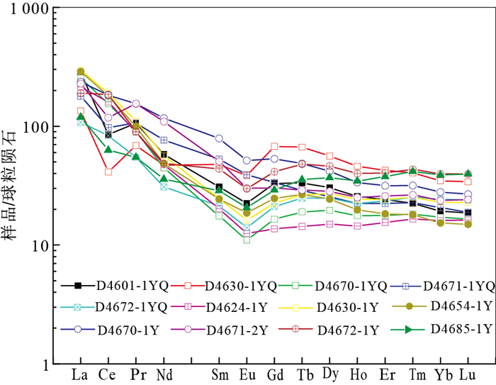
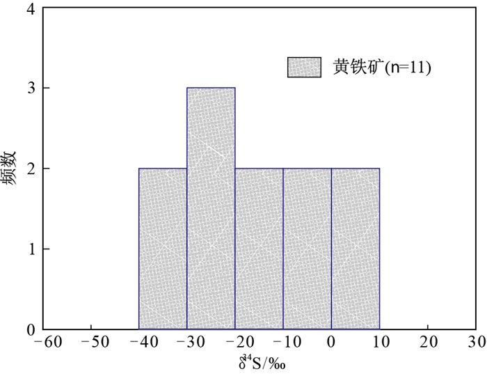
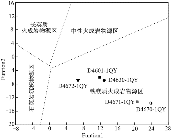
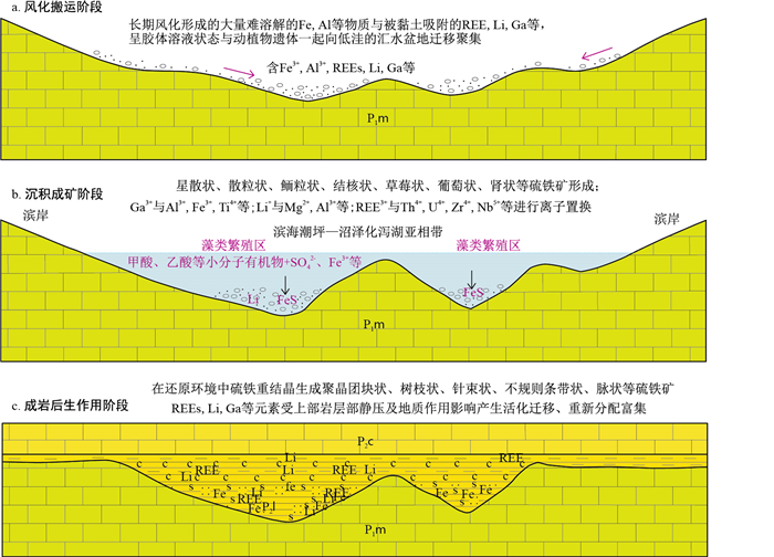
The study of the isotopic and elemental geochemical characteristics and genesis of critical metal-enriched pyritic ore in the Puyi area of Northwest Guizhou provides more abundant information for the exploitation of pyritic ore resources, comprehensive utilization and evaluation of associated beneficial elements, and understanding the mechanism of critical metal-enriched pyritic ore. Based on the comprehensive collection of existing geological and mineral data, combined with field investigation, the geochemical characteristics and genesis of pyrite in this area are studied by using element geochemistry and sulfur isotope analysis, and the metallogenic model is preliminarily established. The study shows that the critical metal-enriched pyritic ore mainly occurs in the crystalline tuff at the bottom of the Longtan Formation of the middle Permian(P2l), and the ore body is simple in shape and distributed in layers. The beneficial elements, such as REEs, Li, Nb, Zr, Li, Nb, Zr, Ga, can be comprehensively utilized. The results show that ΣREE usually ranges from 180×10-6 to 1 630×10-6, with an average of 431.24×10⁻⁶ and up to 1 634.57×10⁻⁶; Ga usually ranges from 25×10-6 to 120×10-6, with an average of 32.51×10⁻⁶ and up to 120.00×10⁻⁶; Nd generally ranges from 40×10-6 to 380×10-6, with an average of 103.29×10⁻⁶ and up to 380.00×10⁻⁶; and the maximum values of Li and Al2O3 are 1 366.00×10⁻⁶ and 42.17%. The REE distribution pattern of pyritic ore is characterized by enrichment in LREEs and relative depletion in HREEs. The ore-forming elements Ga, Li, Zr, Ti, Se, Cd, Nb, V and Hg are relatively enriched, while Ba, Sr, Zn and Te are relatively depleted. The δ34S of pyrite in pyritic ore mainly range from -33.90‰ to -18.60‰(on average of -16.04‰), which shows the characteristics of the enrichment of light sulfur. The sulfur source of critical metal-enriched pyritic ore was greatly affected by the reduction of biological bacteria. Pyritic ore is mainly formed in the sedimentary stage by microbial iron reduction, microbial sulfate reduction and chemical iron reduction. It is suggested that REEs in pyritic ore mainly occur in clay minerals in the form of similar isomorphic substitution, and the formation process can be divided into the weathering transportation stage, sedimentary mineralization stage and diagenetic epigenetic stage.

Indication of biomarkers for coal origin traceability
Li Jiancheng, Li Jing, Yan Xinyou
2022, 41(4): 165-171. doi: 10.19509/j.cnki.dzkq.2022.0118
Abstract:

As the second-largest economy in the world, China has extremely rich coal resources, but the coal resources available for direct mining and utilization are relatively limited and need to rely heavily on imports. To ensure the quality and safety of imported coal, it is urgent to establish a set of effective origin traceability methods to trace the origin and identify the adulteration of imported coal. In this study, coal samples from five importing countries were analysed by gas chromatography-mass spectrometry (GC-MS), and representative biological fingerprint compounds in the organic matter were analysed qualitatively and quantitatively to provide enlightenment for new methods and technologies of coal origin traceability. According to the relationship between Ph/nC18 and Pr/nC17, the coal samples of these five countries are considered to be in the low maturity stage. The coal of Australia, Russia, Malaysia and the Philippines is mainly type Ⅲ organic matter in a terrestrial oxidation environment. Except for the C56 sample from Indonesia, the distribution of n-alkanes in other coal samples from Indonesia and all coal samples from the Philippines mainly have medium and high molecular weight, suggesting that the source of parent material may be terrestrial higher plants. Different samples from different sedimentary environments have different types of organic matter input, and the application of specific indicators of organic matters is an effective method for geographical origin traceability of imported coal to a certain extent.

A preliminary study on the formation conditions and weathering leaching enrichment mechanism of secondary phosphorite in the Xinhua phosphate mining area, Zhijin, Guizhou
Liang Kunping, Cheng Guofan, Qin Qingyan, Wu Rong, Li Bin
2022, 41(4): 172-183. doi: 10.19509/j.cnki.dzkq.2022.0110
Abstract:

The Xinhua phosphate mining are alocated in Zhijin County, Guizhou Province, is a famous superlarge low-grade phosphate deposit containing rare earth elements in the southwest of China.The average P2O5 grade of the deposit is 17.22%.The proven phosphorite ore resources are 1.348 billion tons, and the rare earth resources are 3 500 kilotons.In recent years, experts and scholars have found that the fluctuation of Xinhua phosphorite ore grade is closely related to weathering, leaching and enrichment effects.To further clarify the influence of weathering and leaching on the element geochemistry as well as the secondary enrichment of phosphate rock, the author focuses on the Gezhongwu ore block and carries out field observations and descriptions of phosphate rock series.A total of 19 chemical analysis samples were collected using block knocking method and 16 rock ore samples were identified through polarizing microscope.On these basis, identification and comprehensive research on the samples were conducted.The results show that the contents of P2O5 in the weathered phosphate rock are 8%-18%, higher than that in the primary phosphate rock, while the contents of MgO are 4%-7%, lower than that in the primary phosphate rock.The weathering intensity of phosphate rock is in the weak to mature stage.The formation of Xinhua weathered phosphate rock in Zhijin County is controlled by lithology, geological structure and hydrological conditions.The purpose of this paper is to provide new information for the further study of the influences of the secondary weathering mineralization of the ore deposit on the chemical composition of phosphate rock, to enrich the metallogenic theories of weathering eluvial phosphate mining in China and to provide the oretical guidance for the rational development and utilization of weathering phosphate resources in the mining area.

Prospecting of sedimentary-metamorphic type manganese deposits in the Sifangshan area, northeastern Hubei Province: Insight from magnetic anomaly information
Wang Chuan, Shi Wenjie, Zhu Jiandong, Xu Jiangyan, Chen Song, Li Yanjun
2022, 41(4): 184-196. doi: 10.19509/j.cnki.dzkq.2022.0109
Abstract:

In order to systematically study the prospecting of manganese deposits in northeastern Hubei Province, this study focuses on the typical sedimentary-metamorphic manganese deposits in the Sifangshan area. Based on the anomaly information from a high-precision magnetic survey, the spatial coupling relationship between magnetic anomalies and the manganese deposits. Manganese deposits in the Sifangshan area are predominantly layered and quasi-layered within the Huangmailing Formation (Pt3h) of the Neoproterozoic Hong'an Group. The manganese-bearing sedimentary rocks consist of typical terrigenous clastic-carbonate rocks, including volcanic rocks and argillaceous rocks with silty carbonates.Most manganese-bearing rocks corresponding with medium and high-intensity magnetic anomalies measured by the 1∶50 000 magnetic survey, because they contain a small amount of iron oxides such as magnetite. However, some are also located in the gradient zone of positive and negative magnetic anomaly gradient belts. In the total gradient modulus of 1∶50 000 magnetic survey, the enrichment areas of manganese mineralization correspond to the middle-low values (in particular of the linear gradient zone). Based on the geological characteristics of the Mn deposits, geophysical information, and field investigation results, four ore prospecting targets have been delineated in the Sifangshan area. Target I is located in the northern Sifangshan district. As revealed by exploratory trench TC160, one manganese orebody with a thickness of 2.53 m and an average grade of 14.63% Mn is found in this belt. In target Ⅱ in the Sifangshan district, two manganese orebodies have been revealed the through the exploration trench TC140, one with a thickness of 1.63 m and an average grade of 24.57% Mn, and the other having a thickness of 0.98 m and a grade of 16.73% Mn. One manganese orebody was revealed through the exploration trench TC114 in predicted belt Ⅱ, with a thickness of 1.32 m and an average grade of 17.60% Mn. Manganese mineralization has also been identified in target Ⅳ in southeast of the Tuanshangou district through geological investigation. These new orebodies reported in this study suggest a good prospect for manganese mineralization in the Sifangshan area.

Paleovegetation and paleoclimate in the Baise Basin during Oligocene
Wei Yi, Yang Bing, Deng Huijuan
2022, 41(4): 197-206. doi: 10.19509/j.cnki.dzkq.2021.0078
Abstract:

To reconstruct the palaeovegetation and palaeoclimate in the Baise Basin during the Oligocene, in this work, we analyzed sporopollen fossils from the Fuping Formation in this region. Thirty-four genera sporopollen fossils are found and divided into two assemblages: (Ⅰ) Abietineaepollenites-Quercoidites-Polypodiaceaesporites Assemblage and (Ⅱ) Abietineaepollenites-Pinuspollenites-Pediastrum Assemblage. The age of assemblage Ⅰ and Ⅱ are mid-Rupelian to Oligocene, and late-Rupelian to early-Chattian to Oligocene, respectively. The paleovegetation changed from conifer-broad leaf forest with fern vegetation growing at the bottom to coniferous forest. Through the study of the characteristics of the palynological assemblages, assemblage Ⅰ represents a subtropical humid climate condition with relatively high humidity, while assemblage Ⅱ represents a humid climate condition in the subtropical zone. The coexistence approach of the nearest living relatives of the palynomorphs shows that during the period of the mid-Rupelian to the early Chattian of the Oligocene, the mean annual precipitation (MAP) was 797.5-1 293.7 mm, and the mean annual temperature (MAT) was 11.3-22.6℃ in the Baise Basin. The characteristics of this basin were a northern subtropical climate during the mid-Rupelian to the early Chattian. However, the present Baise Basin is located in the southern subtropics(MAT: 22.0℃, MAP: 1 070.5 mm). The difference between the Oligocene and today may be related to the "right-rotation" of the Asian Plate caused by the collision between the Cenozoic Indian Plate and the Asian Plate.

Enhanced continental weathering and its marine environmental effects in the late Devonian: Constraints from strontium isotopes of carbonate rocks in South China
Deng Faliang, Liu Xijun, Yu Hongxia, Yang Feng, Yuan Yonghai
2022, 41(4): 207-214. doi: 10.19509/j.cnki.dzkq.2021.0071
Abstract:

The Frasnian-Famennian extinction in the late Devonian was one of the largest mass extinction during Earth's history, which was believed to be caused by the plant landing-indued intensification of terrestrial chemical weathering and the consequent hypoxia of marine water. However, direct evidence remains limited. Here, we apply strontium (Sr) concentrations and isotopes (87Sr/86Sr) as well as uranium-thorium ratios (U/Th) of shallow marine carbonate rocks that are widely developed in the Guangxi area to explore the rate of continental chemical weathering and the redox condition of seawater from the middle devonian to lower Carboniferous. The results show that, the intensification of terrestrial chemical weathering in the late Devonian (early Famennian) caused the increase of Sr concentration and the enrichment of heavy Sr isotopes in seawater. The low U/Th ratio in carbonate also suggests that the water was highly hypoxia during this period. Uranium in seawater was reduced and deposited in sediments, resulting in the decrease of U concentration in seawater. The intensification of chemical weathering on land surface has a significant influence on the fluctuation of redox conditions and the extinction of marine organisms in the late Devonian.

EEMs characteristics of dissolved organic matter in water environment and its implications for antimony contamination in antimony mine of Xikuangshan, Hunan Province
Li Wanyu, Zhou Jianwei, Jia Xiaocen, Tang Peidong
2022, 41(4): 215-224. doi: 10.19509/j.cnki.dzkq.2022.0119
Abstract:

Dissolved organic matter (DOM) is an important factor affecting the migration and transformation of antimony(Sb). The Hunan Xikuangshan Sb mine is the largest Sb mine in the world and antimony pollution in the aquatic environment is serious. To determine the characteristics of DOM in the water environment of the Xikuangshan mining area and its influences, three-dimensional fluorescence analysis was performed on the water environment samples of the Xikuangshan mining area. PARAFAC was used to extract the natural organic components in the water environment and the relationship between each component and Sb was explored. The analysis shows that the DOM in the water environment of the mining area is characterized by low humification and mixed sources of terrestrial and microbial sources, and most water samples are mainly terrestrial organic matter. There are three different components in the water body of the Sb mining area of Xikuangshan: the C1 component is terrestrial humus; the C2 component is quinone humus; the C3 component is protein-like (tyrosine). The relative content of the C1 component in the water environment is the highest and the relative content of the C3 component in surface water is higher than that in groundwater. Studies have shown that there are the following ways to affect the release of Sb in the groundwater environment: (1) the complexation of protein-like components with Sb promotes the dissolution and release of Sb; (2) the direct complexation of humus components with Sb. The relative content of natural organic components in surface water with low Sb is affected by dilution. The relative content of natural organic components in surface water with high Sb has a certain indication for the source of Sb.

Migration mechanism of nanoplastic particles in saturated porous media
Ye Xinyao, Wu Ming, Hu Xiaonong, Cheng Zhou, Mo Cehui
2022, 41(4): 225-233. doi: 10.19509/j.cnki.dzkq.2021.0064
Abstract:

To investigate the migration of nanoplastic particles in saturated porous media and the associated influencing factors, polystyrene nanoparticles (PSNPs) are selected as typical nanoplastics in this study. The migration behavior and mechanism of PSNPs in saturated porous media is investigated through a combination of physical experiments and DLVO theory. First, the interaction energy between PSNPs and quartz sand particles is calculated based on DLVO theory, and then a column experiment is conducted to investigate the characteristics of PSNP migration in porous media under different conditions.According to the experimental results, when the ionic strength (NaCl) increases from 1 mmol/L to 50 mmol/L, the value of the energy barrier between PSNPs and quartz sand based on DLVO theory gradually decreases from 215.13 KT to 45.9 KT. PSNPs are easier to be adsorbed on the surface of quartz sand media, thereby reducing the migration ability of PSNPs in porous media, the penetration rate consequently decreases from 62.16% to 3.65%. When the ionic strength (CaCl2) increases from 0.1 mmol/L to 5 mmol/L, the value of the energy barrier decreases from 33.72 KT to 14.03 KT, and the penetration rate decreases from 82.46% to 4.27%. These experimental phenomena indicate that increasing the ionic strength can inhibit the penetration of PSNPs, and Ca2+ has a stronger charge shielding effect than Na+. At the same time, increasing the initial concentration, flow rate and particle size of the medium can increase the penetration rate of PSNPs, while the penetration rate of large-diameter PNSPs particles is smaller. The implementation of this research will contribute to further understanding the environmental behavior and risks of nanoplastics in porous media and provide a scientific basis for accurately predicting and assessing the environmental risks of nanoplastics in soil-groundwater systems.

Analysis on difference of erosion capacity and river capture prediction in the head of the Xiangjiang tributary constrainted by surface and deep geological information
Wang Jing, Xu Yadong, Lin Xiao, Peng Shaoyong, Shi Yuanrun, Zhu Yunhai
2022, 41(4): 234-240. doi: 10.19509/j.cnki.dzkq.2022.0127
Abstract:

Based on the comprehensive method of basic surface geological investigation, GIS watershed analysis and deep geophysical analysis, the difference in retrogressive erosion along the Xiangjiang tributary is compared. Two drainage areas in the head of the Xiangjiang tributary, the Chengjiang and Zhujiang Rivers, are selected as subjects with the same source of erosion at Aitang Village. Under comparison with topography, water level elevation, lithology of bedrock strata, tectonic setting and deep geophysical data, the Zhujiang River has greater erosion ability and stronger headward erosion, with easily eroded bedrock and well-developed joints. It is predicted that river capture could occur around Aitang village. The evolution trend may lead to a decrease in water volume of Liyu town in the lower reaches of the Chengjiang River, which will affect urban domestic water and industrial and agricultural production. In addition, the continuous strengthening of retrogressive erosion can cause downcutting erosion of the Cretaceous red layer and the watershed will present a more spectacular Danxia landscape.

Effects of S2- on arsenic adsorption to river sand and its mechanisms
Du Hailing, Shan Huimei, Chen Hui, Peng Sanxi, Huang Jian
2022, 41(4): 241-248. doi: 10.19509/j.cnki.dzkq.2022.0123
Abstract:

Sulfur (S2-) is closely related to the migration and enrichment of arsenic (As) in the water environment, but its mechanism of action in different aqueous medium is still unclear. To determine the adsorption characteristics of As by river sand, a common aqueous medium in the hyporheic zone, under the action of S2-, the adsorption kinetics experiment of As on river sand and the adsorption experiment of As by river sand under the action of S2- are designed and carried out. Combined with simulation calculation by PHREEQC and characterization tests based on XRD, SEM-EDS, XPS and FTIR, the mechanism of action is further identified. The results show that the adsorption of As by river sand reaches adsorption equilibrium at approximately 200 h and the adsorption capacity of As(Ⅴ) is significantly higher than that of As(Ⅲ) at the solid-to-liquid ratio of 25 g/L; with increasing S2- concentration, the adsorption capacity of river sand to As decreases gradually. The simulation and characterization test results show that a small amount of As is adsorbed on the surface of river sandandis mainly combined with Fe and Al on its surface. The adsorption of As (Ⅲ) may also be related to SiS2 that is formed after the fracture of the Si-O bondwith S2-. The main influence mechanism of S2- on the adsorption of As by river sand is as follows: ① the addition of S2- increases the pH of the solution and decreases Eh, thus inhibiting the adsorption of As; ②under the condition of adding S2-, Fe and Al on the surface of river sand can form compounds such as AlAs, AlAsO4, FeS2 and Fe4As2O11 with S and As, which reduces the active sites of As adsorption on the surface of river sand.

Suitability evaluation of the exploitation and utilization of marine sand resources for construction: Taking the east exit of Qiongzhou Strait as an example
Qin Maogang, Yang Chaoyun, Huang Shirui, Zhu Chaoqi, Tong Changliang, Long Genyuan, Lin Mingzhi
2022, 41(4): 249-258. doi: 10.19509/j.cnki.dzkq.2021.0065
Abstract:

With the rapid development of economy, there is a huge demand for sand and gravel, and the development of marine sand has become a current hot spot. The east exit of Qiongzhou Strait is rich in marine sand resources, and its resource potential is in the billions of square meters. This paper evaluates the suitability of exploitation and utilization of marine sand in the east exit of Qiongzhou Strait.Six indicators of mud content, sand content, grain size, sea sand thickness, water depth and offshore distance are considered.The collected data are analyzed using analytic hierarchy process, where in the weights of considered indicators are calculated and superimposed based on constructed judgment matrix and ArcGIS spatial analysis. Furthermore, the study area are divided into five grades of exploitation suitability. It is found that the marine sand in the shoal area has the best exploitation suitability because of its large scale, good quality, shallow water depth and little influence on mining environment.In addition, this paper analyses the influence of different indicators on the suitability of marine sand exploitation. In the shoal area, the thickness and sand content contribute greatly. In near shore bay, environmental impact is the main factor. In the deep trough area, the water depth becomes the main restrictive condition for marine sand exploitation. Finally, this paper establishes a marine sand exploitation and utilization suitability evaluation system based on key factors of natural property of resources, technical conditions of exploitation, ecological environment impact and administrative management.

A calculation model for the head-on resistance of rock pipe jacking based on the rock breaking characteristics of the disc cutter
Xu Tianshuo, Wang Le, Liu Kaixin, Zhou Yuheng, Ma Baosong, Zhang Peng
2022, 41(4): 259-265. doi: 10.19509/j.cnki.dzkq.2022.0038
Abstract:

Jacking force is one of the most important parameters in the design and construction of pipe jacking. The accuracy of the jacking force will directly affect the success or failure of the pipe jacking project. Pipe jacking is increasingly applied to rock formations, but there are few calculation models for the jacking force in rock formations. To calculate the head-on resistance in the rock formation more accurately, a new calculation formula of the construction face resistance during pipe jacking is derived. The pipe jacking face is assumed to be stable; the rock pipe jacking force is analyzed by consideration of the rock breaking mechanism, force model and influence law of the rock pipe jacking machine cutter head hob. The results show that in rock pipe jacking, the compressive and shear strengths of the rock and the depth of the pipe jacking hob cut into the rock directly determine the value of the head-on resistance; after determining the appropriate hob spacing, the number of tools is not blindly increased; otherwise, the rock breaking effect of each hob will be affected. Moreover, the measured head-on resistance in engineering practice is consistent with the predicted value of the formula, which proves its applicability.

Determination of shear strength parameters and stability analysis of waste disposal area using laboratory large-scale shear testing and engineering geologic analogy method
Wang Jiping, Tang Luosheng, Huang Xuan, Wang Yun'an
2022, 41(4): 266-273. doi: 10.19509/j.cnki.dzkq.2022.0120
Abstract:

The engineering geological classification method has been widely used for determining the shear strength parameters of waste disposal areas in engineering practice; however the calculation error is large.It is necessary to use various methods to comprehensively estiamte the shear strength parameters of the spoil field. Taking a road waste slag yard as an example, the particle size distribution of the slag in the waste disposal area is determined by laboratory particle grading testing, and on this basis, the shear strength of the waste slag is comprehensively determined by indoor large-scale shear testing and engineering geological analogy method parameters.The shear strength is used to perform the stability analysis of the slag body. The results show that the factor of safety of the slag body is 1.369 under natural working conditions and 1.083 under heavy rain conditions, respectively. Additionally, the monitoring results are consistent with the stability analysis, proving that the determination of the shear strength parameter of the slag is reasonable and accurate, and it can provide a reference for the parameter value of the highway waste disposal engineering.

Granule structure influences on force chain development in the slag medium
Lu Minfeng, Tang Zhaohui, Chai Bo, Ning Ke, Zhu Jiewen, Fang Yi
2022, 41(4): 274-281. doi: 10.19509/j.cnki.dzkq.2022.0094
Abstract:

The slag dumps formed by mining activities are irregular granular media. Their particle size gradations are complex and granule structures are unstable.The stress between particles is transferred through the dependently unstable force chain. Taking the typical copper slag as the study object, its granule structure was investigated using CT scanning technology. According to plane compression and corresponding numerical simulation tests on coarse particles of different mass fraction contents, stress-straincurves, force chain evolutions and granule structure changes were obtained.Further, the synergistic effect between granule structure and force chain evolutionon macro-mechanics was discussed. Meanwhile, the compression law of granular material was revealed. The results show that the direction of force chain evolution direction inslag granular materialis consistent with the direction of pressure. The macro-compressive strength of slag increases first and then decreases with increasing coarse particle (>5 mm) mass fraction content and reaches the maximum compressive strength at the optimal coarse particle ratio of 50%. The granule structure and the soft-hard structure inforce chains have a significant synergistic effect. The granule structure change in slag granular material will experience three stages during compression process: the rapid compaction stage, particle crushing stage and stable compression stage. In the process of slag landfill, it is important to keep uniform filling and reasonable compaction to make it enter the stable compression stage, as well as controlling the optimal grading of coarse particles.

Influencing factors of capillary water migration characteristics of the sandstones in Baoding Mountain, Dazu Stone Carvings
Song Jiahang, Yan Shaojun, Xiang Wei, Liu Jianhui, Zhao Gang, Jiang Siwei
2022, 41(4): 282-291. doi: 10.19509/j.cnki.dzkq.2021.0099
Abstract:

The Dafo Bay stone carvings in Baoding Mountain, Dazu District, Chongqing City, are suffering from serious capillary water damage, salt damage, biological and other derivative diseases caused by capillary water, which have brought a long-term negative effect on the protection of the world cultural heritage. Based on the field investigation of the Dafo Bay, the strata of the statuary cliff are divided into three sets: the upper sandstone of the reclining Buddha, the sandstone of the reclining Buddha and the lower sandstone of the reclining Buddha. Through a series of tests and experimental studies, the characteristics of sandstone in the Baoding Mountain area and the influence of temperature and humidity on capillary water are analyzed.The testing items include thin section identification, X-ray diffraction, chemical composition test, scanning electron microscopy, mercury injection test, Karsten tube penetration test, etc.The research results indicated that: compared with the upper and lower layers of the reclining Buddha sandstone, the Reclining Buddha body sandstone has the lowest maturity and the largest porosity and pore distribution range, which provides relatively good conditions for the migration of capillary water. The capillary water absorbability and capillary water elevation of the reclining Buddha body sandstone are the best, and the rise of capillary wateris closely related to the ambient temperature, relative humidity, and air circulation. In the tight sandstone of the Dazu Stone Carvings, a large number of interconnected micropores cannot play a role in the migration of capillary water. The effective pore diameter for capillary water migration in the reclining Buddha sandstone should be above 1 133.0 nm, and may reach 760.2 nm in extreme cases.The research results provide reliable data for an accurate understanding of the formation and evolution of capillary water in Dazu Stone Carvings, explain the formation mechanism of salt damage in Dazu Stone Carvings in winter, and provide a theoretical basis for managing capillary water in Dazu Stone Carvings.

Crust erosion characteristics in the middle reach of the Purlung Tsangpo River
Tu Jiyao, Ji Jianqing, Zhong Dalai, Zhou Jing
2022, 41(4): 292-300. doi: 10.19509/j.cnki.dzkq.2021.0260
Abstract:

To reveal the tectonic evolution process of the eastern Himalayan syntaxis and provide basic geological data for probable significant engineering construction, this study reports 9 biotite 40Ar/39Ar ages in the middle reach of the Purlung Tsangpo River and semiquantitatively calculates the rock erosion rates represented by these ages using the modeling code "Pecube". The measured biotite 40Ar/39Ar ages range from 103-12.5 Ma, corresponding to erosion rates ranging from 0.068-0.5 km/Ma. The rock erosion rates of the Purlung Tsangpo River have obvious differences between the western and eastern sections, which are characterized by the downstream section (western section) being significantly higher than that of the middle section (eastern section). Ages and simulation results show that in contrast to the eastern Himalayan syntaxis, the crust erosion rate in the middle reach of the Purlung Tsangpo River is lower and stable. The Purlung Tsangpo River was captured by the Yarlung Tsangpo River, which allowed the Purlung Tsangpo River downstream (western section) to change into a youth stage of fluvial geomorphological evolution again.The rapid river incised likely resulted in the erosion rate differences between the western and eastern sections.

Updating and application for a reservoir geological model of deep-water turbidites: A case study of a 4D seismic survey from the PU Oilfield in Angola
Zhao Wei, Zhang Wenbiao, Li Meng, Zhao Huawei, Lu Wenming, Lian Peiqing
2022, 41(4): 301-308. doi: 10.19509/j.cnki.dzkq.2022.0115
Abstract:

During traditional updating processes of reservoir models, the final optimal modelis mainly selected referring to the historical matching results from individual drilling wells, as there is a lot of uncertainty in the distribution prediction of remaining oil crosswells. 4D seismic survey is one of the important modern methods for oil reservoir monitoring, and it has a strong advantage forguiding the distribution prediction of remaining oil cross wells. 4D seismic monitoring information is incorporated into conventional updating processes of geological models, to improve the updating accuracy of reservoir geological models. Fluid evolution information provided by 4D seismic surveys lends solid basis for developing an iterative update method with 4D seismic monitoring, geological modelling, and reservoir simulating.Results in this study suggests that ①4D seismic dynamic information can help improve the numerical modelling loops; ②4D seismic surveys can provide important evidence for the cross-well model parameter adjustment, which help promote the quantitative monitoring of remaining oil and improve the accuracy of reservoir model predictions. This method has a good application effect in deep-water turbidite reservoirs and has practical significance for the development of numerical modelling loops.

Shale gas horizontal well geosteering technologies and countermeasures research in narrow and steep syncline formations of northern Guizhou area
Wu Song, Yu Jiliang, Xu Shang, Lan Baofeng, Li Long, Li Gangquan
2022, 41(4): 309-316. doi: 10.19509/j.cnki.dzkq.2022.0136
Abstract:

Northern Guizhou area is located at the edge of the Sichuan Basin, and its structure belongs to Wuling fold area. Wufeng Longmaxi shale stratum is in a series of narrow and steep residual synclines, and the main developed shale stratum is within five meters of the bottom of the Longmaxi Formation, with a thin thickness. Due to the complex surface and underground geological conditions, the seismic velocity changes in this area, and the horizontal and vertical changes in various geological factors, such as the stratum dip angle and thickness, are large, so the drilling rate of horizontal wells in this area is relatively low. In this paper, the difficulties encountered in horizontal well geosteering in the narrow and steep residual syncline are sorted, and the modelling of velocity, structure, thickness, dip angle and curve was carried out. Combined with the element change law and element imaging technology, the track while drilling horizon was identified step by step to improve the hit target rate and drilling encounter rate. The actual drilling results show that the deviation from the geological design was reduced within 25 meters, the drilling encounter rate of high-quality shale was increased to 99.2%, and the drilling encounter rate of the box was increased to 96.5% from 87.6%. Three wells of them achieved the geosteering achievements of hit rate 100%, high-quality shale encounter rate 100%, and box body encounter rate 100%. In areas similar to the narrow and steep residual syncline geosteering difficulty in the northern Guizhou area, the application of this set of technical countermeasures can avoid subtle structural changes such as small folds in time and effectively ensure the box drilling rate of horizontal wells, which can provides solid technical support for horizontal well geosteering.

Study on coal origin traceability technology based on infrared spectrum
Lin Yang, Li Jing, Xia Wenhao
2022, 41(4): 317-328. doi: 10.19509/j.cnki.dzkq.2022.0124
Abstract:

With the increasing dependence of China's coal on the outside world, the problem of coal import adulteration and coal filling is becoming increasingly serious, so it is imperative to establish the accurate, fast, convenient, safe, and environmentally friendly technology of coal origin tracing. In recent years, infrared spectroscopy has been widely used in the field of origin identification in medicine, food, industry and so on. The infrared spectrum contains abundant informationon composition and structure, and the differencesin composition and molecular structure of coals among different countries and regions can be used as the characteristic indications of source tracing. Therefore, in this paper, 30 imported coal samples from 5 countries were collected and analyzed by Fourier Transform Infrared (FTIR) spectrometry, and the characteristics of coal samples from different producing areas were analyzed using principal component analysis, discriminant analysis, and other chemometrics methods.A coal source tracing model based on infrared spectral characteristic information in three countries was established, and its accuracy was verified. The main conclusions are as follows: ①There are differences in the shapes of infrared spectra curves and the types of functional groups in coals from different countries, and the number, position, and intensity of the absorption peaks of the same functional group were also different. ②Based on the infrared spectra data of 23 coal samples from 3 countries, the characteristic information database of functional groups was established, and the principal component analysis and discriminant analysis were carried out for the chemometrics analysis. The traceability models of coal origin in Russia, Indonesia, and Australia were established. ③The accuracy of the origin tracing model is verified by coal samples from known origins, and the accuracy of the result is 100%. The more samples there are, the higher the accuracy and the better the traceability effect of the model.