2022 Vol. 41, No. 5

Display Method:
2022, 41(5): Ⅰ-Ⅰ.
Abstract:
2022, 41(5): Ⅱ-Ⅱ.
Abstract:
Multidimensional study of ore deposits: Current status and future prospects
Chen Huayong, Cheng Jiamin, Zhang Junling
2022, 41(5): 1-4. doi: 10.19509/j.cnki.dzkq.2022.0243
Abstract:

Since entering the 21st century, human society, including science and technology, has experienced dramatic changes in different fields. The ore deposit study has been continued for over 100 years, and many ore deposit models have been established based on numerous deposit case studies, which can be called the "single-dimension" study method. However, such modeling processes are being challenged by the need for further understanding of ore genesis and implications for mineral exploration. With the involvement of new technology such as big data and AI in geosciences, computing, simulation and big data mining are promoting ore deposit modeling to a new development stage. In the future, the experiments of ore-forming processes facilitated by computing and simulation, the mechanism and evolution of erosion and preservation of ore deposits, the genesis of ore formation using big data analysis and AI technology, together with the traditional ore deposit case studies, will form the new research frame of comprehensive ore deposit modeling, which indicates a transition from the current "single-dimension" study to a more robust "multiple-dimension" study of ore deposits.

Typical gravity flow sedimentary features and provenance system in Yinggehai-Qiongdongnan Basin, northern South China Sea
Wang Hua, Chen Si, Liu Entao, He Jie, Gan Huajun, Meng Fulin, Nian Weihao
2022, 41(5): 5-18. doi: 10.19509/j.cnki.dzkq.2022.0245
Abstract:

This study reviewed the sedimentary characteristics and formation mechanism of the Yinggehai-Qiongdongnan Basin based on the lateral sedimentary distribution, vertical sedimentary sequence, and dynamic sedimentary process. Large-scale shallow-water gravity flow deposits developed against a shallow marine background in the Huangliu Formation of the Yinggehai Basin in the northern South China Sea. The submarine fan developed in a semideep marine depositional environment in the Lingshui, Sanya, and Meishan formations of the Qiongdongnan Basin.The main features of shallow marine gravity flow deposits are as follows: ① the scale and distribution patterns of deposits are quite different. ② The sea level changes causes the complexity and variability of sedimentary characteristics. ③ Shallow marine gravity flow deposits usually do not have fan subfacies differentiation of fan subfacies. ④ The channel sandbody of shallow gravity flow is distinguished by rapid migration and thick accumulation, which is reflected by enrichment and multistage stacking of channels.Moreover, the source to sink process and dynamic spatiotemporal changes in different source inputs are revealed through the provenance evolution and comparison of the Yinggehai-Qiongdongnan Basin. The main controlling factors of shallow marine gravity flow development and their coupling relationships are discussed from the aspects of sediment supply, relative sea level change, differential subsidence, and ancient geomorphology (ancient topography break and slope).

Shale formation environment and comprehensive evaluation of shale oil potential of the Lower First Member of Shahejie Formation in Qikou Sag
Zhou Lihong, Chen Changwei, Gan Huajun, Zhang Guangxu, Zhang Yikang, Liu Haitao, Chen Si, Li Zhisheng
2022, 41(5): 19-30. doi: 10.19509/j.cnki.dzkq.2022.0233
Abstract:

Bohai Bay Basin is one of the main exploitation areas of continental shale oil resources in China.Qikou Sag, located in the hinterland of the basin, is one of the typical oil and gas rich depressions in Bohai Bay Basin.This paper selects the organic rich shale in the Lower First Member of Shahejie Formation in Qikou Sag as the research object, and comprehensively uses geochemical logging technology and hydrocarbon generation and expulsion simulation technology to describe the shale sedimentary characteristics and comprehensive evaluation of shale oil potential in the Lower First Member of Shahejie Formation in Qikou Sag.The results show that the Lower First Member of Shahejie Formation in Qikou Sag was deposited in the reduction strong reduction environment with high water salinity, rich nutrients, hot and humid climate, suitable for biological mass reproduction and high productivity.Combined with the hydrocarbon generation and expulsion simulation experiment results, the Lower First Member of Shahejie Formation shale in the study area has strong hydrocarbon generation capacity, high hydrocarbon generation efficiency and low oil discharge rate.Most of the generated crude oil is still left in the shale, which has good exploration potential.The Lower First Member of Shahejie Formation shale in the study area contains an appropriate amount of carbonate minerals, which improves the reservoir conditions during diagenesis and provides a good reservoir site for shale oil.The occurrence of transgression in the southwest margin of Qikou Sag affects the enrichment of organic matter in the Lower First Member of Shahejie Formation from the aspects of sedimentary environment, paleoproductivity and its impact on diagenesis.The enrichment of organic matter, high hydrocarbon generation intensity and good reservoir conditions control the large-area distribution of shale oil in the Lower First Member of Shahejie Formation.Shale oil reservoirs in the Lower First Member of Shahejie Formation in the study area can be divided into carbonate rocks and mixed sedimentary rocks.After synthesizing the oil-bearing characteristics of the two reservoirs, it is found that the mineral content and brittleness index of carbonate rocks have a great impact on shale oil-bearing properties.In the process of further exploration, oil reservoirs can be found in the wide and gentle slope area conducive to the formation of structural fractures and the area with high degree of dolomitization in the study area.The favorable exploration intervals are dolomite, dolomitic shale and calcareous shale with developed pores and micro fractures.The research results provide guidance for the exploration and development of shale oil in Qikou Sag.

A review of luminescence dating on marine sediments
Jiang Tao, Hu Yipan, Zhou Congyan, Chen Kanglin, Liang Chen, Song Lin
2022, 41(5): 31-54. doi: 10.19509/j.cnki.dzkq.2022.0192
Abstract:

During the past 50 years, luminescence dating has been widely applied to dating various marine sediments, which provides important chronological constraints for researches on climate, structure, and geomorphic activities. This paper summarizes articles related to luminescence dating on marine sediments and discusses the details of the development of luminescence dating methodology as well as its applications for marine sediments. The characteristics of luminescence dating on marine sediments in different regions around the world and their contributions to dating the marine sediments by luminescence dating have been summarized. The deposition and burial processes of marine sediments are relatively complex, and insufficient bleaching phenomena are ubiquitous. The saturated water-bearing sedimentary environment makes it difficult to accurately determine the annual dose. Therefore, in the process of dating and calculating the luminescence ages of marine sediments, it is necessary to analyze the luminescence properties of specific samples, select the appropriate equivalent dose test method, and adopt the appropriate annual dose correction method for age calculation. The luminescence dating method has shown unique advantages in various studies of marine sediments since the late Pleistocene. The targeted minerals for luminescence dating commonly exist in marine sediments.With great developments in recent years, the age accuracy has also been significantly improved, which can provide a high-precision absolute chronostratigraphic framework for various studies of marine sediments since the late Pleistocene.

Fracture characteristics and logging identification of lacustrine limestone-shale reservoirs in Da′anzhai Member, Gongshanmiao Oilfield, Sichuan Basin
Wu Feng, Luo Yingying, Li Yuhan, Yang Zongheng, Zhang Hongqian, Liu Jianfeng, Shi Xiangchao
2022, 41(5): 55-67. doi: 10.19509/j.cnki.dzkq.2022.0230
Abstract:

Lacustrine limestone and shale reservoirs are both developed in the Da′anzhai Member of Gongshanmiao Oilfield, Sichuan Basin. Whether fractures are developed or not is the key to the reservoirs in the Da'anzhai Member. Based on core observations, CT scanning and scanning electron microscopy, the characteristics of fractures in limestone and shale were analyzed, the influences of sedimentary facies, mineral content, TOC and faults on fractures were analyzed, and identification plots of fractures in lacustrine limestone and shale were established. The results show that lacustrine limestone is mainly developed with structural fractures and interlayer fractures, while lacustrine shale is mainly developed with interlayer fractures, which are mainly horizontal and low-angle fractures. In the lacustrine limestone, the fractures are mainly developed in the thick limestone, thick limestone with asingle thin shale band and thick limestone with multiple thin shale bands in the Dasan Member and Dayi Member. In lacustrine shale, fractures are mainly developed in the interbeddedthin shale and thin limestone in theDaer-a Member. The ΔGR~ΔlogRTcross plot was preferred for lacustrine limestone fracture identification. Fractures in lacustrine shale were identified by the phenomena of increasing acoustic values and "negative difference" in dual lateral logging. The results can provide ideas and references for fracture evaluation of lacustrine limestone and shale.

Sedimentary environment and shale gas exploration potential of Qiongzhusi Formation in the upslope area: A case study on Well W-207, Weiyuan area, Sichuan Basin
Liang Xiao, Ma Shaoguang, Li Guoqin, Xia Guoyong, Liu Ruolin, Ni Gensheng, Zhang Menglin, Kou Yilong, Yuan Cuiping, Chen Jia
2022, 41(5): 68-82. doi: 10.19509/j.cnki.dzkq.2022.0159
Abstract:

To deeply analyze the thalassochemical conditions and organic matter enrichment mechanism during the Early Cambrian (541-509 Ma)and actively evaluate the potential of shale gas resources of the Lower Cambrian Qiongzhusi Formation(Fm) in the southwestern Sichuan Basin, based on the analysis of the petrology, organic geochemistry, element characteristics, pore structure and adsorption capacity of Qiongzhusi Formation, Well W-207, Weiyuan area, this study has discussed the Early Cambrian paleo-ocean environment, organic matter enrichment control factors and gas-bearing properties of shale gas in the upslope area of the Upper Yangtze Platform. Sedimentary cycle shows that multiple interactive conversioncycles of deep-water continental shelf and shallow-water continental shelf are developed during the fine-grained deposition period of Qiongzhusi Formation under the control of eustasy. In particular, the slope turbidite (fan) and gravity flow sediments indicate that shallow-water continental shelf facies are dominant, and the wells in the upslope of the Weiyuan area are not in deep-water for a long time, with the sedimentary thickness of organic-rich black shale limited. Organic geochemistry evidence indicates that the organic matter of Qiongzhusi Formation in Well W-207 is mainly Type-Ⅰ kerogen, with a high degree of thermal evolution, fewer residual hydrocarbons and a low hydrocarbon generation capacity. The redox parameters indicate that the marine environment on the upslope has a medium restrictive degree, and there is a certain degree of upwelling. The seawater has experienced the transformation process of "anoxic-oxidation-anoxic-secondary oxidation- oxidation". Therefore, the paleo-ocean productivity level in the upslope area is generally low, with an obvious downward trend from bottom to top. The pore structure and nitrogen adsorption curve show that the reservoirs of the Qiongzhusi Formation are mainly complex and irregular slit pores. The methane adsorption capacity is positively correlated with TOC but negatively correlated with temperature, indicating that the high-pressure and high-temperature conditions generally faced by the Qiongzhusi Fm are not suitable for methane adsorption. As a result, the geological conditions of shale gas for Qiongzhusi Fm in the upslope area are complex. With high exploration risk, this study suggests that the resource evaluation direction should change to the intracratonic sag (downslope area), which is characterized by deep-water continental shelf facies.

Advance in alkaline dissolution of sandstone
Tian Jianfeng, Yu Jian, Zhang Zhiguo
2022, 41(5): 83-93. doi: 10.19509/j.cnki.dzkq.2022.0195
Abstract:

Alkaline authigenic minerals such as chlorite, laumontite, albite, and illite formed by alkaline dissolution of volcanic materials and feldspar are the focus of sandstone reservoir research, but alkaline dissolution itself is often ignored. Through analysis of the alkaline dissolution mechanism, controlling factors and diagenetic characteristics, it is found that alkaline dissolution includes five types: alkaline dissolution of quartz grains, hydrolysis and dissolution of volcanic materials, K-feldspar dissolution caused by illitization of montmorillonite, K-feldspar dissolution caused by illitization of kaolinite, and albitization of plagioclase. As alkaline dissolution is often superimposed with acid dissolution, it is difficult to directly determine the type and scale of alkaline dissolution and is often ignored or misjudged as acid dissolution. Based on the genetic relationship between alkaline dissolution and its associated cements, the type and scale of alkaline dissolution of some sandstone reservoirs are analyzed. Alkaline dissolution is very common in the petroliferous basin of China, and the secondary pores formed by the first four kinds of alkaline dissolution can reach 2%-7%, 5%-10%, 1.32% and 1.63%, respectively.

Prediction of tight sandstone reservoirs based on waveform indication simulation
Du Jia, Liu Yancheng, Bai Jiebin, Zhang Yingchun, Lin Liming, Shi Suzhen
2022, 41(5): 94-100. doi: 10.19509/j.cnki.dzkq.2022.0155
Abstract:

With the deepening exploratory development, geological targets are gradually shifting from conventional reservoirs to unconventional ones. The sandstone reservoirs in the northeast margin of the Ordos Basin are stacked vertically and change quickly horizontally with thin thicknesses. Therefore, traditional inversion technology cannot satisfy the requirements of precise prediction of thin reservoirs. To solve this problem, this paper integrated geological, seismic and logging data based on the GR curve. A wave form simulation of the MG block in the eastern margin of Ordos Basin was conducted, and the distribution of sandstone reservoirs in the target bed was depicted. The results showed that the waveform indication simulation profiles had a high resolution both horizontally and vertically. They were also in line with the drilling well and strongly correlated with the seismic waveform, which could reflect the spatial variation in the reservoir and accord with the law of geological deposition in the study area. Therefore, as a more efficient inversion method, waveform indication simulation provided a strong support for the refined study of thin inter-bedded reservoirs and helped to maximize the development and utilization of gas resources.

Geological process and carbon cycle significance of graphite carbon material in faults and subduction zones
Cao Shuyun, Zhou Dingkui
2022, 41(5): 101-111. doi: 10.19509/j.cnki.dzkq.2022.0240
Abstract:

Carbon is a common element in nature that exists in various forms, including single minerals (e.g., graphite and diamond), compounds (e.g., carbonate and carbon dioxide) and organic carbon in organisms. Graphitized carbonaceous materials often form or appear in the rocks of fault zones or subduction zones at different crustal depths and are especially abundant in some large earthquake fault zones. Previous studies have shown the significant role and status of graphitized carbonaceous materials in rock deformation behavior and geological evolution processes. This reveals that the texture of graphite crystals is sensitive to temperature. In the geological process, the crystalline order of carbonaceous materials, that is, the graphitization process, is irreversible, so that the peak metamorphic temperature can be recorded quantitatively. Graphite crystals also have other special structural and physical mechanical properties. Duringthe deformation process, it can effectively reduce the strength of rock and promote plastic deformation. The graphite material in the crust can weaken the rock strength and cause seismic fault slip, which plays an important role in thesolid lubricant and rheological weakening process of faulting or deformation in the fast-sliding or seismic sliding plane. Graphitic carbonaceous materials have low solubility and low mobility and often exist in the deep crust as carbon sinks. On the geological time scale, once carbon and graphitization participate in the rocks together, some major geological processes, such as subduction, faulting, weathering and erosion, as well as biological processes, can cause graphite carbonaceous materials to enrich or release carbon to the earth's surface (atmosphere) through the formation and destruction process, which will significantly affect the carbon cycle.

Methods and prospects for lithospheric structure imaging
Shan Bin, Zhou Wanli
2022, 41(5): 112-121. doi: 10.19509/j.cnki.dzkq.2022.0241
Abstract:

In recent years, with rich observation data, the perfection of physical chemistry theory and the remarkable improvement of computer technology, great changes have taken place in the understanding of lithospheric physical and chemical properties. This paper introduces the current imaging methods of lithospheric structure and their advantages and disadvantages. Based on thermodynamic simulation and probability density inversion, we study the lithospheric thermal and compositional structure in South China (Sichuan Basin, Jiangnan Orogenic Belt, Lower Yangtze Craton and Cathaysian Block)using the observed Rayleigh wave phase velocity dispersion curve, geoid height, topography and surface heat flow. The results show that the lithosphere in the east of South China block is thin, and the lithospheric mantle is dominated by fertile peridotite, while the subduction of the Pacific plate from east to west may be the main dynamic mechanism of lithospheric thinning in the east of South China.Finally, we introduce the existing problems of lithospheric structure imaging and the prospect of future lithospheric structure imaging based on the current research status of lithospheric structure.

Advances in composition and dating methods of fault gouge and weakening mechanisms of earthquake faults in bedrock area
Xu Xianbing, Deng Fei, Wang Dun, Luo Xiyi
2022, 41(5): 122-131. doi: 10.19509/j.cnki.dzkq.2022.0138
Abstract:

Fault gouges result from the sliding of brittle faults and can be used to determine the deformational characteristics, formation ages and weakening mechanisms of earthquake faults, which are of great significance for structural geology and earthquake geology. Therefore, the comprehensive understanding of the research findings and its advances in fault gouges will contribute to palaeoseismic investigations. On the basis of collected and absorbed data, we introduced comprehensive advances in the components of fault gouges, surface textures of quartz grains from fault gouges, dating methods of fault gouges and weakening mechanisms of earthquake faults. The fault gouge is mainly composed of clay minerals and powder and debris of wall rocks. The clay minerals mainly consist of montmorillonite, illite, kaolinite and chlorite. The powder and debris of wall rocks are mainly composed of quartz, feldspar, mica, calcite and dolomite. Quartz, illite and calcite selected from fault gouges could be used to distinguish the polysstages of faulting and date its formation ages. Geochronological methods include surface texture analysis of quartz grains, electron spin resonance (ESR) and optically stimulated luminescence (OSL)dating of quartz, K-Ar or 40Ar/39Ar dating of illite, and U-Pb dating of calcite. The weakening mechanisms of earthquake faults consist of the powder of minerals, the formation of new minerals and fabric development in fault gouges, and frictional heating, frictional melting and thermal pressurization after fault initialization.

Carbon isotope composition and its evolution around the base of the Drumian Stage in Linzhou area, northern Henan
Chen Yonglin, Wang Xi, Wang Yanhui, Yao Shuai, Bai Guodian, Fang Huaibin
2022, 41(5): 132-140. doi: 10.19509/j.cnki.dzkq.2022.0196
Abstract:

Carbon isotope stratigraphy is an important means to subdivide and correlate the Cambrian strata. Based on the carbon isotope analysis of the carbonate strata of Lütuogou Section, northern Henan Province, it is found theδ13C value of carbonate samples collected from the base of the Drumian Stage at Lütuogou Section, northern Henan, ranges from 3.1‰ to -1.7‰, and theδ18O value ranges from -3.9‰ to -9.4‰. No covariance exists betweenδ13C andδ18O, which implies that the carbon isotope composition is nearly stable. Value ofδ13C around the base of the Drumian Stage consists of a negative excursion, the amplitude of the negative excursion is 3.0‰, and the minimum value ofδ13C is -1.7‰, which occurs at the place 15 m below the first occurrence of trilobite protasaphiscus. The position and amplitude of the negative excursion are similar to those of the drum carbon isotope excursion (DICE) tested in the Wangcun Section, western Hunan, South China, and the Drum Mountains section in Utah, USA, which suggests that the DICE can be used as a global indicator for the correlation of the Drumian Stage. Furthermore, the cyan shale with thin limestone at the position of minimumδ13C overlies the oolitic limestone; therefore, DICE occurs in the transgressive succession in the early Miaolingian.

Experimental study on creep behaviors of red sandstone in Sichuan and Chongqing under acid corrosion
Xie Ni, Wang Dinghao, Lü Yang, Gao Qing
2022, 41(5): 141-149. doi: 10.19509/j.cnki.dzkq.2022.0142
Abstract:

The creep characteristics of rock have an important effect on the long-term stability of rock engineering. Especially under the action of acid rain and other water chemistry, the rock microstructure is destroyed, and the creep characteristics and deformation are more significant. With the red sandstone of the Erfo Temple in Chongqing as the research object, the creep characteristics of sandstone under acid corrosion are studied by triaxial compression creep test. The results show that the porosity of sandstone increases with acid corrosion and immersion, which leads to the large instantaneous strain and creep of sandstone under the first stage load, and then the instantaneous strain and creep increase with the increase in stress. The creep strength is 76% of the compressive strength, and the long-term strength is only 54% of the compressive strength. To describe the whole creep process, a damage creep model is established to fit the test data, and its applicability is verified, which provides a reference for geotechnical engineering construction.

Effect of stimulation in hot dry rock reservoirs from carbon dioxide blasting-induced cracking
Dou Bin, Xiao Peng, Zheng Jun, Tian Hong, Cui Guodong, Wu Tianyu
2022, 41(5): 150-159. doi: 10.19509/j.cnki.dzkq.2022.0194
Abstract:

Carbon dioxide blasting provides a new technical idea and way to stimulate hot dry rock reservoirs. To explore the effect of carbon dioxide blasting-induced cracking on dry-hot rock reservoirs, a numerical simulation for the action range of carbon dioxide blasting-induced cracking of hot dry rock was carried out. Considering the cooling effect of drilling fluid on the hot dry rock reservoir near the wellbore in the actual mining process, the fitting functions with temperature difference as a variable were adopted to set the material parameters of the reservoir in the damaged area, and the temperature distribution functions of the reservoir near the wellbore after well washing were adopted to set the temperature field of the reservoir in the damaged area. The blasting load was set by the relevant theories and formulas of explosive blasting. Combined with COMSOL software, the process of carbon dioxide blasting to stimulate hot dry rock reservoirs was simulated. The results showed that there were multiple stress concentrations in the process of the dry hot rock cracking caused by carbon dioxide blasting, the compressive stress concentration near the blast hole produced the crushing zone, and the tensile stress outside the crushing zone formed the fracture zone. In addition, the initial temperature of the reservoir and the thickness of the pressure plate would affect the effect of carbon dioxide blasting fracturing to stimulate dry and hot rock reservoirs. The initial temperature had a great influence on the scope of the blasting crushing zone and had little influence on the scope of the fracture zone. The thickness of the pressure plate had little influence on the scope of the crushing zone, which mainly affected the distribution of the blasting fracture zone. The research results could provide a theoretical support and a reference for the subsequent exploitation and utilization of dry-hot rock geothermal energy.

A review on source identification of dissolved sulfate in groundwater: Advances, problems and development trends
Jin Menggui, Zhang Jie, Zhang Zhixin, Cao Mingda, Huang Xin
2022, 41(5): 160-171. doi: 10.19509/j.cnki.dzkq.2022.0161
Abstract:

Effective identification of the sources and biogeochemical processes of dissolved sulfate in groundwater is an important prerequisite for ensuring drinking water safety and aquatic ecological security and is of significance to manage and protect groundwater resources. In this review, the sources of groundwater sulfate and the typical range ofδ34S andδ18O isotope from different sulfate sources are summarized by reviewing the literature; the identification of sulfate sources and S biogeochemical cycles byδ34S andδ18O isotope in sulfate is reviewed, and the existing problems and development trends are proposed. The source apportionment of groundwater sulfate sources has gone through the processes of hydrochemistry analysis→δ34S isotope→dual isotope→qualitative identification of multiple isotopes and tracers→quantitative evaluation. Due to the differences in sulfur and oxygen isotopes and the biogeochemical transformation processes in a specific region, there is still a larger uncertainty in the determination of groundwater sulfate sources.It is proposed to arrange the sampling points for collecting pollution sources and groundwater samples on the framework of groundwater flow systems and land use distributions and to analyze the hydrochemical components and the sulfur and oxygen isotope values of sulfate and other complementary tracer isotope values and/or concentrations in a specific area. The sources and their contributions of groundwater sulfate are analyzed using multidisciplinary and multi-methods based on the full integration of hydrogeochemistry, seepage field, land use and other information in a study area for the scientific implementation of groundwater resource protection and pollution prevention.

Geochemical behavior of rare earth elements in high-temperature hot springs and its indications: A case study in the Daggyai hydrothermal area, Tibet
Guo Qinghai, Zhang Xiaobo
2022, 41(5): 172-180. doi: 10.19509/j.cnki.dzkq.2022.0244
Abstract:

The Daggyai hydrothermal area (Tibet) is located on the southern margin of the Lhasa-Gangdise terrane and adjacent to the middle of the Indus-Tsangposuture. Acid, neutral, and weakly alkaline hot springs are ubiquitous in Daggyai, offering a peerless opportunity to study the distribution of rare earth elements (REE) in various geothermal waters as well as their geochemical origins. In this study, different types of the Daggyai hot springs were systematically collected to determine their REE concentrations, to discern the REE patterns and to calculate the REE speciation, which is helpful for revealing the indications of the geochemical behavior of REEs in high-temperature geothermal environments. The results of the study show that the REEs in the Daggyai hot springs behaved conservatively, with their concentrations being affected by the sorption of Fe-or Al-rich minerals or amorphous phases instead of sulfate minerals, and the REE patterns and speciation were controlled by the redox conditions and fluid-rock interactions in the reservoirs, capable of reflecting the geological genesis and the general hydrochemical characteristics of the hot springs. Although the major constituent hydrochemistry of the Daggyai hot springs demonstrates that the reservoir host rocks are primarily felsic rocks, the negative Ce anomaly of the neutral-to-alkaline hot springs implies that there are possibly carbonate rocks in the Daggyai reservoirs. This work is a typical example of relevant studies on REE geochemistry in high-temperature hot springs.

Coral reef bleaching monitoring based on multitime Landsat-8 remote sensing image series
Wu Ke, Yang Fan, Xu Ying
2022, 41(5): 181-189. doi: 10.19509/j.cnki.dzkq.2022.0242
Abstract:

In recent years, due to the influence of human activities and global warming, the coral reef ecosystem in the South China Sea (SCS) has degraded, and bleaching occurs. Utilizing the remote sensing method to monitor and understand the bleaching status of coral reefs is of great value to the protection and management of the ecological environment in the SCS. This study first obtains coral reef bleaching alert areas (BAAs) through multiperiod sea surface temperature data (SST) and selects the Antelope Reef in the Yongle Atoll of the Paracel Islands as the research area. Then, a new coral reef bleaching monitoring model is proposed, which uses water depth correction, coral reef classification, reflectance adjustment and threshold selection to carry out multitime series coral reef bleaching monitoring research with Landsat-8 remote sensing images from 2013 to 2018. The results show that the model can effectively obtain coral reef bleaching areas and provide a feasible approach for the monitoring of coral reef bleaching in the South China Sea.

Progress on karst carbon cycle and carbon sink effect study and perspective
Zhang Cheng, Xiao Qiong, Sun Ping′an, Gao Xubo, Guo Yongli, Miao Ying, Wang Jinliang
2022, 41(5): 190-198. doi: 10.19509/j.cnki.dzkq.2022.0193
Abstract:

Carbonate weathering is an important part of the global carbon cycle, acts as an atmospheric and soil CO2 sink. Driven by ecosystem factors and affected by global change, carbon sinks in karst areas have the characteristics of surface and underground carbon sinks.This work briefly introduces the relationship between the karst carbon cycle and global change, discusses the related scientific issues and main progress of karst carbon sinks, analyzes the potential of karst sink increases and land use changes, and further proposes a conceptual model of carbonate weathering processes based on the concept of karst critical zones.Carbon sink generated by weathering of carbonate rocks may contribute to the "missing sink" of the global carbon cycle and play a role in mitigating the release of soil CO2 to the atmosphere, thus becoming an important regulator of the item of "land use change" (ELUC) in the global carbon cycle model.The carbonate weathering process responds quickly to short-time scale environmental factors, which is the core driving mechanism that connects biological, hydrological, as well as geochemical processes in karst critical zones.The karst carbon cycle can be regarded as an extension or lateral component of the soil-ecosystem carbon cycle, which together constitute a complete terrestrial shallow surface carbon cycle system in karst areas.The negative feedback effect of carbonate weathering on the increase of atmospheric CO2 concentration and the continuous promotion of rock desertification control and ecological restoration contain huge potential for karst carbon sequestration and sink increase.The monitoring and research on seasonal and regional variations in soil CO2 should be strengthened, and an inverse model based on the correlation between soil CO2 and the watershed hydrochemistry index should be constructed to estimate the background of the regional carbon sink and evaluate the annual carbon sink increment and potential, thus providing a clearer and effective scheme and approach for karst sink increase.

Review of research progress of karst groundwater in northern China
Liang Yongping, Shen Haoyong, Gao Xubo
2022, 41(5): 199-219. doi: 10.19509/j.cnki.dzkq.2022.0199
Abstract:

The Middle-Upper Proterozoic and Lower Paleozoic carbonate aquifers in northern China are continuously deposited with large thicknesses and wide distribution areas. Karst groundwater plays an critical role in national economic construction due to the rich water resources stored in karst aquifers. It is a national strategic water resource in China. Based on the author's investigation and research experience on karst water in northern China, this work provides a preliminary summary of the research progress and shortcomings in the aspects of karst groundwater systems and hydrogeological conditions, evolution trends and causes of environmental problems, utilization and protection of karst groundwater, ecological restoration and technical methods of investigation and research. This paper sends a congratulation to the 70th anniversary of the establishment of China University of Geosciences and the 40th anniversary of the establishment of theBulletin of Geological Science and Technology.It also provides a reference for hydrogeological colleagues of karst groundwater research in northern China.

Overview of groundwater modeling technology and its application in karst areas with multiple-void media
Cheng Jianmei, Luo Yiming
2022, 41(5): 220-229. doi: 10.19509/j.cnki.dzkq.2022.0220
Abstract:

Due to the extremely heterogeneous distribution of karst and the multi-media nature of karst aquifer medium, the groundwater flow in karst water system presents complex and changeable characteristics. It follows Darcy flow law in the pores or fissures, and non-Darcy flow law in the karst pipelines, which brings great challenges to groundwater modeling in karst areas. This paper systematically worked through the main methods of karst water flow and solute transport simulation, summarized the current situation of groundwater simulation technology in complex karst multimedia systems, and pointed out the key issues that should be considered in the practical application of karst water modeling according to the characteristics of karst in south and north China. The main findings include: it is necessary to strengthen field investigations and observations to improve the accuracy of the characterization of the heterogeneity of karst aquifer media in the model. Furthermore, the research on the mechanism of karst water movement should be deepened to depict the flow characteristics and the water exchange mechanism in the karst multimedia. For the simulation of karst water systems in North China, the equivalent continuous porous media model can be selected, focusing on the coupling model of slow seepage in the karst pore fissure media with the rapid flow in the strong runoff zone. For the karst area in South China, it is suggested to consider the establishment of a coupling model between the distributed watershed hydrological model and the multimedia karst groundwater model that can describe the changes in various flow regimes in complex multiple-void media.

Earth's critical zone and karst critical zone: Structure, characteristic and bottom boundary
Pu Junbing
2022, 41(5): 230-241. doi: 10.19509/j.cnki.dzkq.2022.0191
Abstract:

Critical zone science has become an important research area in Surface-Earth system science, representing a future new concept and developing trend in Earth system science. The karst critical zone, a unique type, covers approximately 15.2% of the global ice-free continental land, which is a typical case and represents the Earth's critical zone. However, there is still a lack of a unified understanding of the scientific connotation of the karst critical zone (KCZ) and a lack of related discussions on the structure, characteristics and lower boundary of the KCZ at present. On the basis of reviewing the history of the scientific development of the Earth's critical zone and summarizing its main characteristics, this study sorts out the background and development processes of the concept and summarizes the characteristics of the KCZ. The bottom boundary of the KCZ, which is still controversial, is analyzed and discussed, and the further development direction of the KCZ is also analyzed. These results show that the KCZ is a unique type of Earth's critical zone shaped by material circulation and energy flow at the interface of the lithosphere, hydrosphere, atmosphere, biosphere as well as pedosphere in soluble rock areas. The spatial span of the KCZ ranges from the vegetation canopy to the lower boundary of the karst aquifer in the soluble rock area, including the vegetation layer, soil layer, epikarst, vadose zone and saturated zone, which are sensitive to environmental changes and have surface and subsurface double geological structures and special geochemical processes characterized by coupling cycles of carbon, water and calcium. By comparison, the KCZ has eight following characteristics: active involvement of carbonate rock in the material cycle, sensitive response to external environmental changes, multilayer hydrogeological structures, strong horizontal spatial heterogeneity, large underground space network, large-span biota structure, unique ecohydrological processes with carbonate rock water-vegetation interaction as well as varying lateral boundary controlled by subsurface divide change. The bottom boundary of the KCZ is the depth at which the groundwater recharged by precipitation has no influence on the dissolution of carbonate minerals (calcite, dolomite, etc.) and has no ability to further dissolve carbonate minerals (calcite, dolomite, etc.) in a certain range below the surface. According to the development trend of the disciplines and national strategic demands, further attention should be paid to the following four directions: the structure, formation and evolution mechanisms of different types of the KCZ; the ecological service function and regional sustainable development in degraded karst ecological zones; the impacts of engineering activities on the structure, attributes and evolution process of the KCZ; and the coupling process between climate change and the change in the structure, function and attributes of the KCZ.

Influence and repair of underground engineering construction on karst flow field
Xing Liting, Yu Miao, Su Qingwei, Zhao Zhenhua, Gao Yang, Zhang Yunfeng
2022, 41(5): 242-254. doi: 10.19509/j.cnki.dzkq.2022.0190
Abstract:

Engineering construction changes the groundwater flow field and endanger the safety of buildings. Taking the large-scale underground complex along Jinan Jingshi Road as an example, the impact of engineering construction on the groundwater seepage field is obtained by numerical simulation, and the groundwater flow field repair models are established. These results show that the underground spatial structure will block the normal movement of groundwater, and will reduce the bearing capacity of the foundation after the groundwater level is raised. After adding diversion measures to the underground space, the water level at the upstream surface will decrease with time, and the closer it is to the natural state, the slower the water level attenuation rate is. Due to the difference in the stratum structure, there is a great difference in the time when the backwater level basically drops. The number of diversion wells required to repair the flow field under different geological conditions has a negative correlation with the structural parameters of diversion geometry. The established equation for predicting the number of diversion wells fully reflects the complexity and variability of geological conditions in karst areas. In addition to the structure of the fluid conducting geometry, the hydraulic gradient and permeability coefficient of the surrounding rock also affect the water conducting capacity of diversion measures. The permeability coefficient controls the speed of the water conducting rate, while the hydraulic gradient controls the occurrence of water conducting behavior. The implementation of diversion measures can reduce the impact of engineering construction on the groundwater environment and ensure that the impact of underground engineering construction on the water environment is controllable.

Simulation study on remediation of acid mine drainage by in-situ injection of limestone based sustained release materials
Gao Xubo, Li Hongyu, Gong Peili, Zhang Xingzhou, Fang Jiancong
2022, 41(5): 255-263. doi: 10.19509/j.cnki.dzkq.2022.0221
Abstract:

The karst area is widely distributed in China, and the ecological environment is fragile. Acid mine drainage (AMD) produced by mining activities in karst areas seriously threatens the safety of regional ecological environment. In this paper, carbonate rocks and corn cobs (biochar) widely distributed in karst areas were used as raw materials, and an alkaline sustained release material (ASRM) that could be used for in-situ injection and repair was prepared by means of modification, granulation and film coating. In addition, in-situ injection and repair experiments under alternating effects of wet and dry conditions were carried out in the laboratory, to verify and determine the ability and removal mechanism of ASRM in the in-situ remediation of heavy metals in acid mine wastewater. The results showed that ASRM can effectively improve the pH of water, and the pH of AMD can be increased from 2.8 to approximately 5-7, and it had a good removal effect on many harmful heavy metals, such as Fe2+, Mn2+, Zn2+, Cu2+, Cd2+, Pb2+ and Cr3+. XRD and SEM analyses showed that the reaction precipitates mainly existed in the form of FeOOH. The removal mechanism of heavy metals mainly includes: ①some metal ions were removed in the form of precipitation, such as hydroxides produced by the reaction; ②a large amount of FeOOH produced by the reaction system can adsorb and remove heavy metals. This experimental study provides a reliable theoretical and technical basis for the in-situ treatment of AMD in karst mountain mines with high efficiency by using slow-release materials.

Hydrochemical characteristics and controlling factors of karst groundwater in middle and upper reaches of Dawen River basin
Gao Zongjun, Wan Zhipeng, He Keqiang, Victor Kuzin, Liu Jiutan
2022, 41(5): 264-272. doi: 10.19509/j.cnki.dzkq.2022.0186
Abstract:

To determine the hydrochemical characteristics and ion sources of karst groundwater in the middle and upper reaches of the Dawen River basin, based on karst groundwater samples collected in dry and wet periods in 2018, hydrochemical data were analyzed by means of mathematical statistics, correlation analysis, Piper diagram, Gibbs diagram and ion ratios. The results showed that the average pH values of karst groundwater in dry and wet periods in the middle and upper reaches of the Dawen River basin were 7.6 and 7.5, respectively, showing weak alkaline conditions as a whole. Ca2+ was the dominant cation in karst groundwater, and HCO3- and SO42- were the main anions. The average contents of TDS in karst groundwater during the dry and wet periods were 645.4 mg/L and 648.4 mg/L, respectively. According to TDS, the karst groundwater in the upper and middle reaches of the Dawen River basin belonged to freshwater or brackish water; hydrochemical types of karst groundwater in dry and wet periods were mainly HCO3·SO4-Ca. Rock weathering was the main controlling factor affecting the hydrochemical characteristics of karst groundwater in the area. The dissolution of carbonate and silicate minerals was an important source of groundwater ions. At the same time, the karst groundwater in the upper and middle reaches of the Dawen River basin was also affected obviously by human activities, and NO3- in groundwater mainly came from agricultural production activities.

Distribution of aquatic fauna in karstic groundwater and its enviro-nmental response on the south bank of the Yangtze River in Yichang
Liu Wei, Duan Jiawen, Zhao Ruichao, Wang Yi′an, Li Yin, Chen Wei, Li Qiuhua, Zhou Hong, Anton Brancelj
2022, 41(5): 273-282. doi: 10.19509/j.cnki.dzkq.2022.0218
Abstract:

To understand the distribution of aquatic fauna in karst groundwater and its environmental response, aquatic fauna and water samples were collected from 15 epikarst springs and 9 large karst springs on the south bank of the Yangtze River in Yichang from July to August 2018. In total, 809 individuals were collected, and they belonged to 13 subclasses. We found that: ①The spatial distribution of different animals in groundwater was different. Copepoda and Ostracoda stygobionts were abundant in epikarst springs (31.3%, 23.7%), Trichoptera and Diptera were less abundant (0.4%, 2.9%). Copepoda and Amphipoda were abundant in large springs (25.0%, 8.3%), Ostracoda stygobionts were less abundant (2.2%). ②The variation range of environmental factors (pH, Na+, Ca2+, Mg2+) in large karst springs (0.64, 1.25 mg/L, 34.0 mg/L, 22.1 mg/L) was narrower than that in epikarst springs (2.45, 5.68 mg/L, 59.6 mg/L, 33.4 mg/L), which indicated a relatively stable condition. ③According to the stepwise regression analysis, the main environmental factors of epikarst springs were pH, Na+ and Mg2+, and the main environmental factors of large karst springs were pH, SO42- and Mg2+. Moreover, the representative biological communities of epikarst springs were Ostracoda, Diptera and dark layer species of Turbellaria, and the representative biological communities of large karst springs were Mollusca, Diptera and Decapoda. ④According to the path analysis, Diptera mainly responded indirectly to Na+ and Mg2+ through Ostracoda, and Ostracoda stygobionts, Diptera and Turbellaria responded directly to pH in epikarst springs. In large karst springs, Mollusca mainly indirectly responded to pH through Diptera, Diptera indirectly responded to SO42- through Decapoda, and Mollusca, Diptera and Decapoda directly responded to Mg2+. The distribution of fauna in groundwater was the result of a direct response to environmental factors and an indirect response between different species.

Spatial variations and influencing factors analysis of heavy metals in the soil of typical rocky desertification peak cluster depression
Qin Xingming, Ma Guobin, Jiang Zhongcheng, Hu Baoqing, Xie Weiwei, Tan Shuai, Cao Yuwei
2022, 41(5): 283-292. doi: 10.19509/j.cnki.dzkq.2022.0189
Abstract:

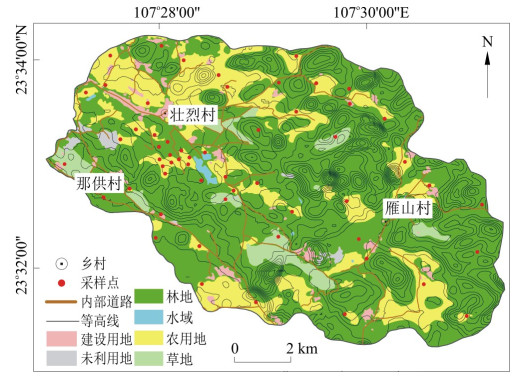
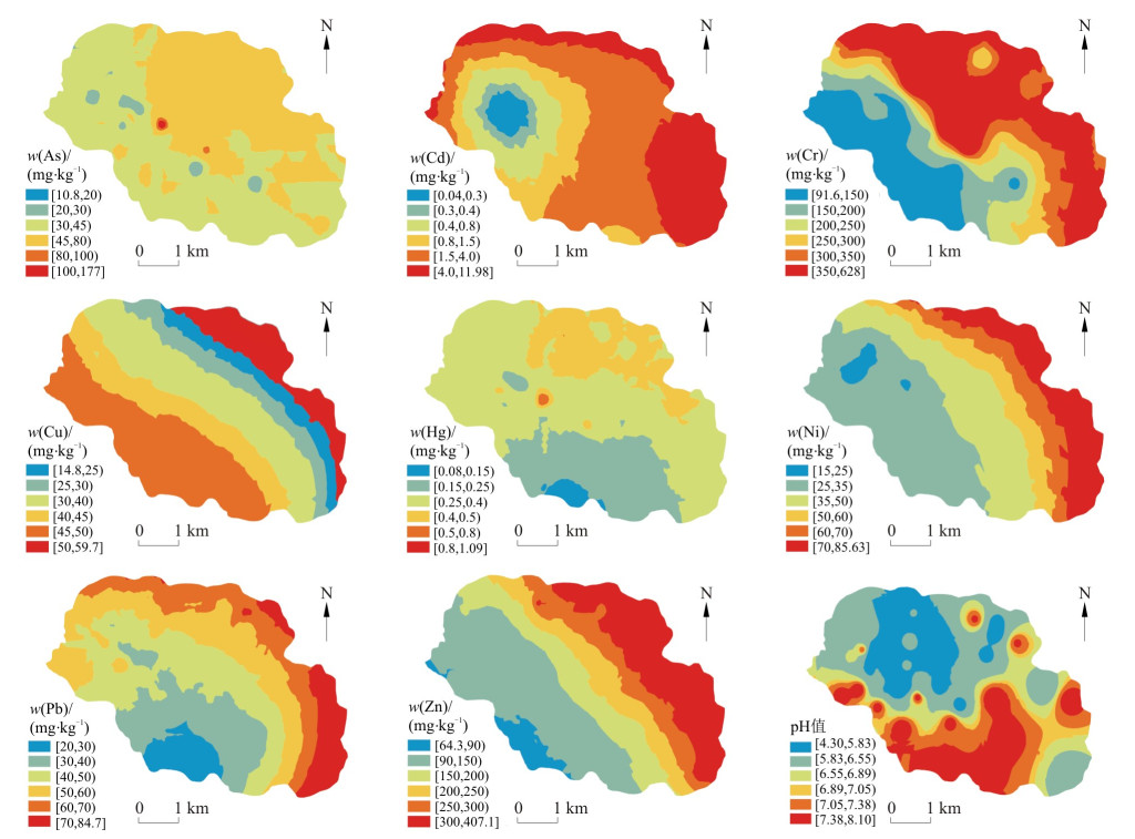
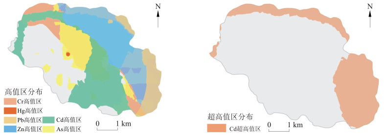
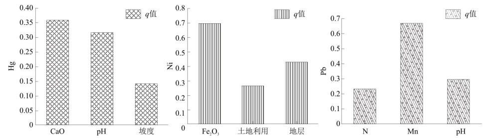
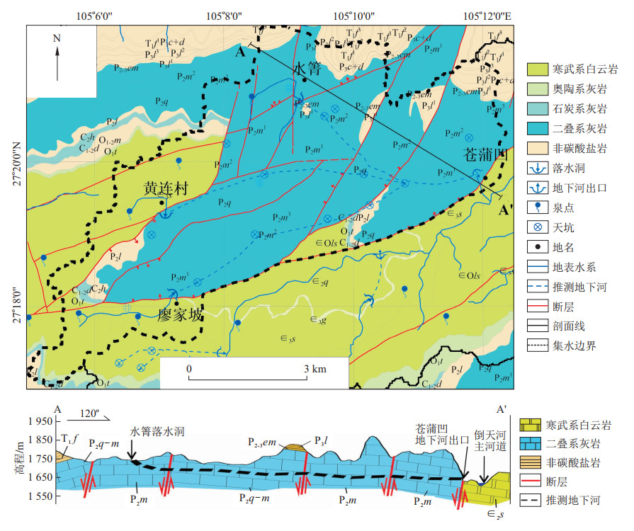
Karst peak cluster depression areas are characterized by a special double-layer hydrogeological structure, and under the influence of human activities, there are many environmental problems, such as soil erosion, rocky desertification, dryness and wetness, and heavy metal pollution. How to clarify the spatial variations and influencing factor analysis of heavy metals in the soil of typical rocky desertification peak cluster depressions has become an important content to promote the prevention and control of heavy metal pollution in soil and the comprehensive management of rocky desertification. The typical rocky desertification peak cluster depression soil in Pingguo City, Guangxi, was selected as the research object in this study.Spatial variations, associated mechanisms and pollution risk assessments of eight heavy metals (e.g., As, Hg, Cr, Ni, Cu, Zn, Cd, and Pb) in soil were carried out by using the geo-statistical, geological accumulation index, potential ecological danger index and geographical detector methods. These results show that the spatial distribution of heavy metals in the study area generally shows a downward trend from northeast to southwest. Cr and Cd show medium spatial correlation, and the other six heavy metals show strong spatial correlation, which was analyzed by semivariogram. The study area is affected by different pollution levels of Cd, As, Cr, Cu and Zn, and the impact of Cd is the most important. The geological accumulation index and potential ecological hazard index of Cd are 1.34 and 107.73, respectively, but the average geological accumulation index of other heavy metals is less than 0, and the potential ecological hazard index is less than 16.The main factors affecting the spatial differentiation of eight heavy metals in the soil of the study area are pH, stratum, Fe2O3, land use, phosphorus, CaO, Mn, distance to fault and rocky desertification degree. Moreover, the interaction types of different factor groups on the spatial differentiation of heavy metals in soil were mainly two factors enhanced and nonlinear enhanced. Therefore, it is considered that different factors have different effects on the spatial differentiation characteristics of various heavy metals in the soil of rocky desertification peak cluster depression. Cd is the most serious heavy metal element in the soil pollution degree and potential ecological harm degree of rocky desertification peak cluster depression. Strata, Mn, CaO, lithology, distance to fault and phosphorus are the key factors affecting the spatial differentiation of Cd.

Estimation method of recharge area based on hydrograph simulation of karst water
Luo Mingming, Jiang Guanghui
2022, 41(5): 293-300. doi: 10.19509/j.cnki.dzkq.2022.0184
Abstract:

The determination of the recharge area of karst water systems is difficult in karst hydrogeological investigations and research. Based on the principle of water balance and hydrological impulse function, this work introduces the calculation method to estimate the recharge area and discusses the physical meaning of the model parameters. Three typical karst water systems in South China were tested, namely, the Yaji experimental site in Guangxi, the Wulongdong underground river in Xingshan, Hubei, and the water inrush point of the Xiakou Tunnel near the Hu-Rong highways, which are well verified with the recharge area comprehensively determined by other methods. The estimation method of the recharge area based on karst hydrograph simulation proposed in this paper is a new supplement to the methods for calculating the recharge area of karst water systems and has a good application prospects in small and medium scale karst water systems in South China.

Modelling the hydrological process of the karst spring using a revised Vensim model
Chang Yong, Qi Yaoyong, Liu Ling
2022, 41(5): 301-307. doi: 10.19509/j.cnki.dzkq.2022.0188
Abstract:

The conventional Vensim model uses two parallel reservoirs to simulate the slow and fast flows in karst systems, which can hardly simulate the existing nonlinear hydrological process. This paper proposed a revised Vensim model (R-Vensim) to further enhance its ability to simulate the nonlinear hydrological process in karst systems. This revised version changed one linear reservoir in the Vensim model into a nonlinear reservoir and considered the variation in the distribution coefficient under different hydrological conditions. The two models were applied to simulate the discharge of karst spring S31 located at the Yaji experimental site. The simulation results indicated that the R-Vensim model can reasonably reproduce the discharge dynamics under different precipitation conditions, whereas the Vensim model underestimated the fast flow peaks and overestimated the slow flow peaks. In the study catchment, the fast flow was almost linear, whereas the slow flow was highly nonlinear. In the calibration period, 78.5% of spring discharge came from the nonlinear reservoir. The results showed that, considering the nonlinear hydrological process was a key issue to accurately simulate the karst spring, particularly for the slow flow condition.

Interpretation of stalagmite δ18O in East Asian summer monsoon region: Based on the relationship between summer monsoon and summer monsoon rainfall
Yin Jianjun
2022, 41(5): 308-314. doi: 10.19509/j.cnki.dzkq.2022.0201
Abstract:

The climate significance of stalagmiteδ18O values from the East Asian monsoon region are still under much debated during the past years. The bone of contention focuses on whether the stalagmiteδ18O can reflect the summer monsoon intensity or summer monsoon rainfall, either reflecting the vapor source variation. To better understand the significance of stalagmiteδ18O in this region, This study analyses the relationship between stalagmiteδ18O, summer monsoon rainfall and El Niño-Southern oscillation (ENSO) activity from the interannual-decadal timescale to the millennial-orbital timescale. This work is based on the anti-phase relationship between North China rainfall and the middle and lower reaches of the Yangtze River and the East Asia/Pacific (EAP) teleconnection. The results show that the more depleted stalagmiteδ18O corresponds to higher rainfall in North China and lower rainfall in the Meiyu area, and more enriched stalagmiteδ18O corresponds to lower rainfall in North China and higher rainfall in the Meiyu area. This relationship is found not only on interannual to decadal timescales but also on millennial to orbital timescales. Therefore, the stalagmiteδ18O could reflect the summer monsoon intensity and shows a consistent relationship with rainfall in East China. We also found that stalagmiteδ18O influenced by ENSO only occurred in the rainfall regime in East China, and the effect on stalagmiteδ18O by the convective activity in the source area induced by ENSO activity was neglected. For example, in the La Niña state, the convective activity in the South China Sea and the Philippine Sea is enhanced, the position of the West Pacific subtropical high (WPSH) is farther north, the Meiyu rainfall in the middle and lower reaches of theYangtze River is shortened, the summer rainfall in North China is prolonged, and stalagmiteδ18O is depleted. In the El Niño state, the convective activity in the South China Sea and the Philippine Sea is depressed, the position of the West Pacific subtropical high (WPSH) is farther south, the Meiyu rainfall in the middle and lower reaches of the Yangtze River is prolonged, and the summer rainfall in North China is shortened, and stalagmiteδ18O is enriched. In addition, the vapor source analysis indicates that the vapor transport from the Philippine Sea has a minor influence on the stalagmiteδ18O in the East Asian summer monsoon region. Finally, we conclude that the stalagmiteδ18O in the East Asian summer monsoon region is an East Asian summer monsoon intensity proxy.

Characteristics of the karst water system on the northeast wing of the Huangling anticline and its impact on water diversion tunnel engineering
Yan Huiming, Chang Wei, Ji Huaisong, Deng Zhengrong, Guo Xulei, Chen Lin, Huang Kun
2022, 41(5): 315-323. doi: 10.19509/j.cnki.dzkq.2022.0165
Abstract:

The strata in the northeast wing of the Huangling anticline consist of interbedded carbonate rocks and clastic rocks. As the carbonate rocks underwent strong karstification, karst water inrush would be a significant factor impacting the construction of underground engineering in this area. Taking the Huangling anticline section of a critical national water diversion project as the research object, the characteristics of the karst groundwater system and the water inrush conditions in tunnels were identified by various methods, such as karst hydrogeological surveys, tracer tests and hydrogeochemistry analysis. These results show that the aquifer system contains four sub-aqueous systems with a structure of strong and weak permeable interlayers in the vertical direction, in which a multi-stage karst groundwater system has developed with shallow rapid circulation, intermediate rapid circulation and a deep slow circulation subflow systems. The faults constitute the vertical channels for hydraulic exchange between sub-aquifer systems. The water diversion tunnel primarily crosses the deep Dengying Formation (Z2dn) and Tianheban-Shilongdong Formation(∈1t+sl) aquifer systems with weak karst development. However, a large-scale high-pressure water inrush accident may occur when passing through the Dianya fault, which may transfer groundwater from the upper karst sub-aquifer system of the Loushanguan Formation-Nanjinguan Formation (∈3l-O1n) into the tunnel. The risk of encountering conduit water inrush accidents is high during construction when the construction branch tunnel passes through the discharge area of the Bailongdong groundwater flow system in the ∈3l-O1nsub-aquifer systems. The accuracy of identifying of karst groundwater flow system features and inrush conditions can be improved by joint interpretation of multiple hydrogeological methods.

Characterization of karst conduit structure based on multisource artificial tracer test: A case study of the Cangpuwa underground river in Guizhou Province
Geng Xinxin, Zhang Feng′e, Chen Zongyu, Nie Zhenlong, Zhu Pucheng
2022, 41(5): 324-332. doi: 10.19509/j.cnki.dzkq.2022.0185
Abstract:

Artificial tracer test is an important research method in the field of karst hydrogeology. In this study, to understand the distribution characteristics of karst conduits more comprehensively, multisource tracer tests were carried out on the Cangpuwa underground river in the base flow period and precipitation conditions. The results showed that tracers from Shuiqing, Huangliancun, and Liaojiapo were detected in the base flow period and precipitation conditions. The tracer recoveries under precipitation conditions were 88.12%, 90.01%, and 84.01%, respectively, indicating that the Cangpuwa underground river was a multisource and single-sink underground river. According to the tracer transport characteristics in both the base flow period and precipitation conditions, a conceptual model of the Cangpuwa underground river karst conduit structure was constructed. The flow path from Shuiqing to Cangpuwa had the largest curvature, the flow path from Huanglian to Cangpuwa was mainly a karst conduit, there were two channels on the flow path from Liaojiapo to Cangpuwa, and there was a dissolved pool near the outlet of the underground river. The research results can provide a basis for the investigation and exploitation of water resources in complex karst underground rivers.

Application of sulfur and oxygen isotopes in identifying the source of sulfate in karst water from Xin′an spring area
Hu Xiaobing, Fang Jiancong, Zhai Huwei, Zhang Kai, Ma Yongming, Jin Jianhong, Gao Xubo
2022, 41(5): 333-340. doi: 10.19509/j.cnki.dzkq.2022.0166
Abstract:

An extremely high sulfate content is one of the main reasons for the deterioration of karst water quality in the Xin′an Spring area. Identifying the source of sulfate is of great significance for fully understanding the hydrogeochemical process in karst water and for the rational development, utilization and protection of karst water resources. In this work, the source of sulfate in karst water from the Xin′an Spring area is identified by sulfur and oxygen isotope. These results show that the sulfate in karst water mainly comes from gypsum dissolution, surface water leakage and pit water infiltration, and gypsum dissolution and mixing with surface water is the majority. This study provides important environmental and hydrogeological information for the protection, rational development and utilization of karst water resources in the study area.

Research progress on the dissolved and particulate carbon of reservoirs in karst areas of Southwest China
Yi Yuanbi, Wang Wanfa, Wang Baoli, Wang Fushun, Li Siliang
2022, 41(5): 341-346. doi: 10.19509/j.cnki.dzkq.2022.0200
Abstract:

Southwest China is the largest concentrated karst landscape distribution area in the world, with dense river networks and abundant hydroelectric resources in the area, which is an important area for the development of hydroelectric power generation in China. To elucidate the impact of karst reservoirs on the carbon cycle of the river system, this work summarizes the research progress of damming in karst watersheds on different forms of carbon transport transformation and the environment in recent years. Through the study of dissolved inorganic carbon (DIC), dissolved organic carbon (DOC), particulate inorganic carbon (PIC) and particulate organic carbon (POC) transport and transformation and their control mechanisms in the river-reservoir system in the karst region by spectroscopy, stability and radioisotopes, this work found that the carbon cycle in karst reservoirs exhibits obvious seasonal distribution characteristics, as well as cascade reservoirs, which may further amplify a single reservoir's environmental influence. These results not only contribute to the understanding of the reservoir carbon cycle but also help to explore the "missing" carbon sinks in the river carbon cycle and to more accurately assess the role of karst reservoirs in the global river carbon cycle. In general, karst reservoirs are likely to be more responsive to increased anthropogenic activities than nonkarst reservoirs, which implies that the role of karst reservoirs in the global warming trend needs to be more accurately assessed, and in future research, a systematic characterization of the carbon transport and transformation of different forms from microscopic to macroscopic levels by different analytical tools will more accurately answer this question.

Hydrochemical characteristics and genesis analysis of typical aquifer system in karst critical zone of Central Yunnan Plateau
Huang Jingyu, Xu Mo, Xu Hanhua, Liu Wenlian, Yang Yanna, Tang Yige, Xiao Xianxuan
2022, 41(5): 347-356. doi: 10.19509/j.cnki.dzkq.2022.0217
Abstract:

The study of hydrogeochemical processes in the karst critical zone (KCZ) is of great significance for the scientific understanding of their internal evolutionary environment and structural characteristics. Karst groundwater is the main information carrier after water-rock interactions. Quantitative analysis of its hydrochemical characteristics and causes is an effective means to reveal the medium environment and hydrodynamic conditions of the aquifer system in the KCZ. In this paper, three typical karst aquifer systems in the KCZ of the central Yunnan Plateau were taken as the research objects. Through field sampling and laboratory testing of karst springs exposed by different aquifer systems, mathematical statistics analysis, hydrochemical diagram, ion ratio coefficient and hydrogeochemical simulation were comprehensively used to deeply analyze the characteristics of hydrochemical components, genesis and aquifer medium of karst groundwater in each aquifer system; the internal relationship and law between the water cycle and hydrochemistry in the key belt were discussed. The results showed that: ①HCO3- and Ca2+ were the highest and most stable ion components in regional karst groundwater, and Mg2+ was the key factor controlling the alienation of hydrochemical types in each aquifer system; ②The rock weathering and mineral dissolution of carbonate rocks were the main causes of the chemical composition characteristics of karst water in each aquifer system, and karst groundwater dissolution on the aquifer of the Huaning aquifer system was still occurring. The alternation of cation adsorption and the weathering and dissolution of silicate rocks were the main sources of Na+ and K+ in regional karst groundwater; ③The development intensity of regional karst, the exposed condition of karst aquifers and the lithology and connectivity of aquifer media jointly shaped the groundwater chemical characteristics of different aquifer systems in the KCZ of the Central Yunnan Plateau.

Numerical simulation of saturated-unsaturated groundwater flow and contaminant transport in a karst aquifer
Zheng Xiaokang, Yang Zhibing
2022, 41(5): 357-366. doi: 10.19509/j.cnki.dzkq.2022.0211
Abstract:

Groundwater in karst aquifers is an important source of drinking water. Due to the complexity of hydrogeological characteristics, it is extremely challenging to analyze and evaluate the groundwater environment in karst aquifers by numerical modeling. In this study, a variable saturation flow equation is used to describe the saturated-unsaturated flow in the aquifer matrix, a pipe flow equation is used to describe the laminar and turbulent flow in karst conduits, and the convective dispersion equation is used to describe solute transport in the matrix and conduits. The accuracy of saturated-unsaturated flow simulation is verified by comparison with experimental data and simulation results from the MODFLOW-CFP code. The numerical model is used to explore the effects of karst conduits and unsaturated parameters on groundwater flow and contaminant transport. These results show that the numerical model can well reproduce the groundwater dynamics in saturated-unsaturated regions and in the karst conduit of the aquifer; furthermore, the karst conduit has a great influence on the seepage field of the aquifer. Relatively rapid flow in the conduit leads to the inflow of surrounding groundwater, affecting the local flow field. As a result, the contaminant is transported through advection in the conduit and is quickly discharged through the outlet(spring). Breakthrough curves show that the response of concentration at the spring is faster than the corresponding location in the matrix. Unsaturated parameters have different effects on the breakthrough characteristics. The model established in this paper improves the simulation methods of groundwater flow, pollutant transport and coupling of matrix-conduit flow with solute transport in the saturated-unsaturated region in karst aquifers. The work deepens the understanding of groundwater dynamics and contaminanttransport in karst aquifers and is thus of great significance to karst hydrogeology and groundwater environment protection.

Genesis of karst groundwater contamination based on system spatial feature recognition
Ning Hang, Wang Zongxing, Liu Futian, Jiang Wanjun, Chang Wei, Zhang Jing, Wan Junwei
2022, 41(5): 367-376. doi: 10.19509/j.cnki.dzkq.2022.0187
Abstract:

The karst groundwater system has a complex spatial structure, strong aquifer permeability and poor anti-pollution performance. Once pollution occurs, the pollutants spread rapidly, and the repair is difficult. This study takes the pollution of a large karst spring in South China as an example. On the basis of a karst hydrogeological survey, combined with hydrochemical characteristics and multiple-tracer technology, the boundary of karst groundwater system and the distribution of underground river pipelines were analyzed, and the main pollution sources and pollution routes of the karst spring were identified. In addition, the genetic model of karst groundwater pollution was also explored. These results showe that the Q1 karst groundwater system was a typical "multi-source, single-sink" groundwater circulation pattern with two main runoff channels in the north and south. Manganese, total bacterial counts, ammonia nitrogen and total phosphorus were the main substances exceeding the standard, which were 17, 14, 7.2 and 3.8 times the groundwater quality standard threshold, respectively. The construction waste blocked the original channel of the underground river, forcing the groundwater to divert and flow under the landfill. Engineering investigation and dynamic compaction activities destroyed the natural clay impermeable stratum under the landfill, resulting in the early transport of domestic garbage and leachate entered into the karst pipeline, both of which caused the pollution of karst groundwater. This study provides an important reference for the prevention and control of karst groundwater pollution.

History of karstification and groundwater flow field within Triassic water-bearing strata in Julongshan syncline
Fan Yu, Chang Wei, Wei Shiyi, Wan Junwei, Huang Kun
2022, 41(5): 377-385. doi: 10.19509/j.cnki.dzkq.2022.0160
Abstract:

The Triassic water-bearing strata in the Julongshan syncline experienced the comprehensive effect of multiple periods of karstification, and the evolution law of karst development is of great significance for understanding hydrogeological conditions and analyzing the groundwater flow field in this region. In this paper, the history of the characteristics of tectonic evolution and karst development in the Julongshan syncline were studied by means of history comparison and combined with data on water chemistry, isotopes and drilling of Triassic water-bearing strata, and the evolution process of the groundwater flow field was preliminarily restored. Our results showed that the tectonic movement in the study region was characterized by vertical rise or fall during the Sinian and the Middle Triassic, which provided materials for karst development in marine sedimentary strata. However, there was no condition for karst development. The main ancient karstification ocourred in the period of time at the top of the Permian Maokou Formation and Triassic Jialingjiang Formation. From the Late Triassic to the Early Jurassic, the crustal movement in the Julongshan syncline was dominated by slow uplift, and terrigenous clastic strata were successively deposited in the lake basin of the Jingdang Basin due to the clastic rocks of the Triassic Badong Formation, which were widely overlying carbonate rocks and had just undergone denudation. This period mainly manifested as burial karst under the water. From the Middle Jurassic to the Early Cretaceous, the EW-NW folds and faults or fissures were formed by Yanshanian movement, controlling the plane distribution pattern of carbonate rocks. During this period, part of the carbonate rock was exposed, karstification began to develop, and the surface water and the underground water converged into the Jingdang Depression. From the Late Cretaceous to Paleogene, with the formation of the Jianghan fault depression basin, the clastic denudation line of the caprock of the Badong Formation gradually retreated to the south, and the development of karst was further strengthened. The old karst drainage system and part of the groundwater drained to the lowest datum level of the Jiangling fault depression. Since the Neogene, the intermittent and rapid uplift of tectonic movement has caused the development of karst to depth, the formation of the Grade Five karst planation surface and multistage groundwater flow system, and the drainage of surface water and groundwater to the Yangtze River. The groundwater flow field has a multilevel evolution mechanism from the limestone region to the depression-faulted basin and the Yangtze River.

Geological significance of karst section of Lower Triassic Feixianguan Formation in Puguang area, Northeast Sichuan
Liang Xinyang, Fu Dekui, Zhang Ning, Gao Qiuling, Zhang Xionghua, Chen Jian
2022, 41(5): 386-394. doi: 10.19509/j.cnki.dzkq.2022.0164
Abstract:

Reservoir strata with carbonate rocks of Feixianguan Formation are the main output horizons of natural gas in Puguang Gas Field, Northeast Sichuan. As to the division of four members of Feixianguan Formation, the controversy regarding whether the T1f1 member and T1f2 member should be classified in the same third-order sequence appears. Based on the core observation of the existing drilling in Puguang area, the karst breccia section is found atthe middle of the T1f1-T1f2 section, and there is a certain lithologic interface above and below it. The bottom of T1f1 is fine-grained dolomite. From the top of T1f1 to T1f2, oolites and mould casting holes begin to develop.The carbon and oxygen isotope study in Well PG104-1 shows that the fluid environment is atmospheric freshwater fluid, which proves the development of quasi-syngenetic karst, while the oxygen isotope value is more than -5‰, indicating that the relevant fluid is atmospheric freshwater fluid, which proves that the bottom of the karst breccia section experiences a certain period of exposure and that a sedimentary discontinuity appears.Considering the differences in carbon and oxygen isotopes between the upper and lower interface, the emergence and disappearance of die casting holes and the changes in logging curves, it is considered that the boundary between T1f1 and T1f2 can be distinguished and characterized by karst breccia sections. This study provides an important basis for the study of the storage and migration of oil and gas in Feixianguan Formation.

Structure of karst water system and hydrological circulation characteristics of Lianghu Tunnel in Wuhan
Ma Chao, Zeng Bin, Luo Mingming, Quan Feng, Yu Lijun, Li Qijia, Dai Ang
2022, 41(5): 395-404. doi: 10.19509/j.cnki.dzkq.2022.0198
Abstract:

Among the underlake tunnels in the urban areas, the Lianghu Tunnel in Wuhan is the longest one of China and the largest one in the world.The East Lake part of this tunnel passes through the karst area. Identifying its karst water system structure is of great significance to the safety of tunnel construction and operation.To reveal the structure of the karst water system and the characteristics of the water cycle in the area, a comprehensive method of geological-hydrogeological investigation and hydrogeochemical analysis was conducted to characterize the boundary of the karst aquifer system, summarize the karst development law, identify the source of cave sediments, analyze the hydraulic connection between karst water, pore water and surface water, as well as discuss the hydrological circulation model of the karst water system.The results show that the study area can be divided into two karst aquifer systems, the north and the south.The karst development degree is stronger in the northern karst aquifer system than that in the southern karst aquifer system but has a unified hydraulic connection through the fault zone. The cave sediments mainly derived from Quaternary residual layers and the weathering of the cave surrounding rock.The pore water in the Quaternary alluvial-pluvial aquifer has a weak hydraulic connection with karst water, while the pore water in the Quaternary residual aquifer has a close hydraulic connection with karst water.The karst water system structures of underlake tunnels were characterized by a variety of techniques and methods, which helps the risk assessment of water inrush and the safe construction of tunnel engineering.

Hydrogeochemical indicators of hierarchically nested structure of karst groundwater flow systems in the ejective folds area
Li Yayi, Xia Qiang, Xu Mo, Cao Cong
2022, 41(5): 405-413. doi: 10.19509/j.cnki.dzkq.2022.0162
Abstract:

The karst groundwater flow system in the ejective folds area in the eastern Sichuan Basin shows the characteristics of a hierarchically nested structure. However, previous studies were mainly focused on hydrogeological conditions analysis, lacking qualitative evidence directly from hydrochemistry. In this study, the authors collected and sorted the chemistry data of representative karst springs and boreholes in the study area, namely, 41 shallow karst waters and 19 deep ones. The Pipper chart shows that the shallow karst water is HCO3-Ca·Mg and low Mg2+ concentration, while the deep karst water is SO4-Ca·Mg and high Mg2+ concentration. For both shallow and deep karst groundwater, the analysis of the groundwater flow system of a typical profile shows that the Mg2+ concentration value can be used to evaluate the groundwater residence time. The shallow karst groundwater system is highly controlled by geomorphology, among which the shallow incised valley springs are the discharge points of the local groundwater flow system. However, springs in deep gullies correspond to intermediate or even regional flow systems. This pattern is verified by the groundwater residence time evaluation from the Mg2+ concentration, which also reflects the movement characteristics of deep-circulation groundwater flow revealed by hot springs and boreholes.The hydrochemical characteristics can effectively indicate the pattern of groundwater flow systems. This paper provides a reference for identifying the hierarchically nested structure of groundwater flow systems in similar karst areas.

2022, 41(5): 414-414.
Abstract:
2022, 41(5): Ⅲ-Ⅳ.
Abstract: