| Citation: | WU Liyang, YIN Kunlong, ZENG Taorui, LIU Shuhao, LIU Zhenyi. Evaluation of geological disaster susceptibility of transmission lines under different grid resolutions[J]. Bulletin of Geological Science and Technology, 2024, 43(1): 241-252. doi: 10.19509/j.cnki.dzkq.tb20220307

|
The safe operation of transmission lines is of great significance for national economic construction and development, but there were few studies on the evaluation of geological hazards susceptibility to transmission lines.
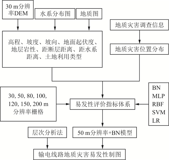
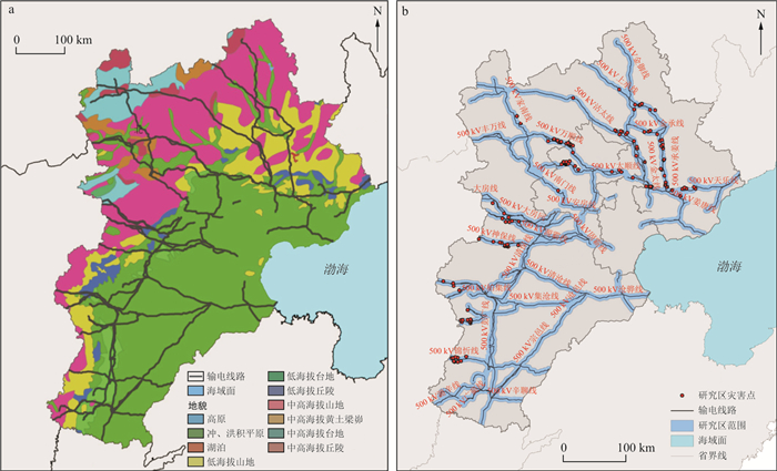
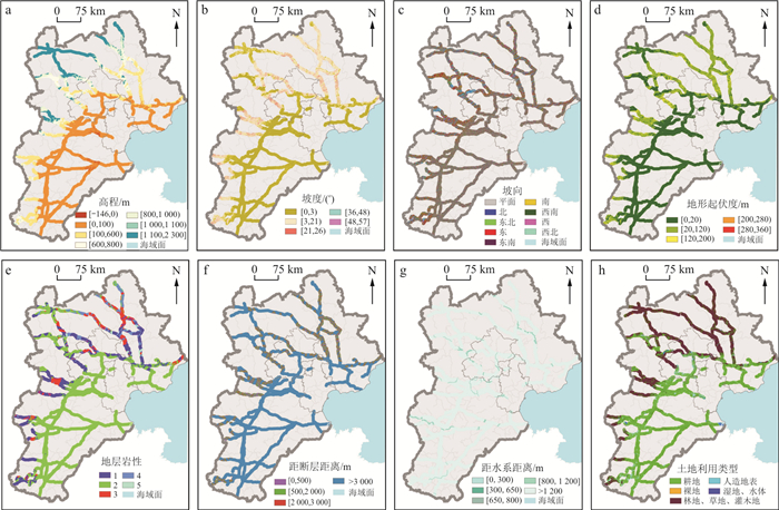
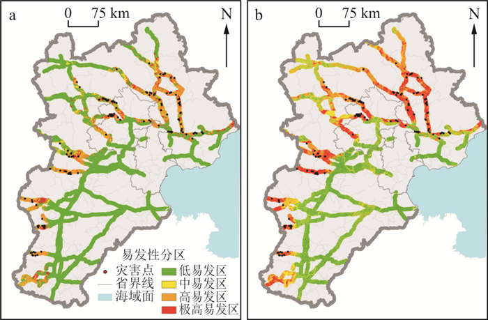
This study focuses on the Beijing-Tianjin-Hebei region as an example, where eight index factors, including elevation, slope, aspect, terrain relief, stratigraphic lithology, distance from fault, distance from water system, and land use type were selected. The frequency ratio method was used to classify each index factor to construct a susceptibility evaluation system.Then used different machine learning models and grid of different spatial resolutions as evaluation units to evaluate the susceptibility of the study area.Finally, the machine learning model with the highest accuracy and the traditional Analytic Hierarchy Process (AHP) were selected to complete the susceptibility zoning map of the study area.
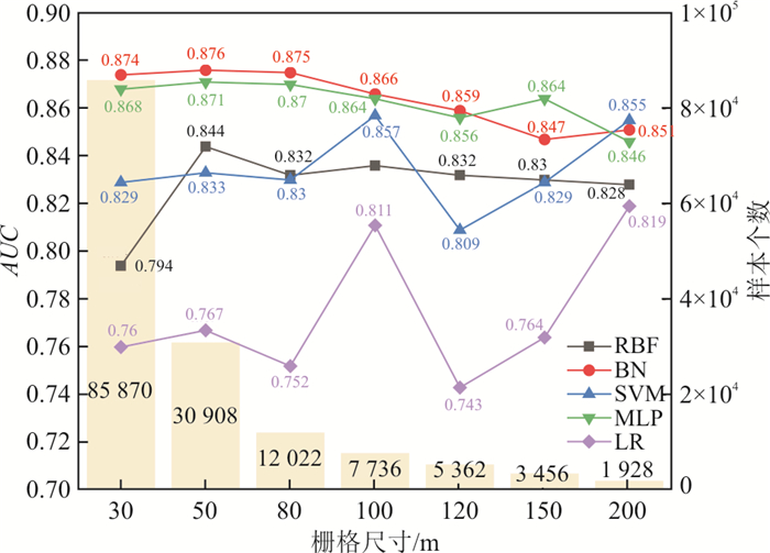
The research results show that the Bayesian Network model (Bayesian Network, BN) had the best application effect and the strongest model performance in the susceptibility evaluation of regional transmission lines, and the maximum AUC value was 0.876. The BN model outperformed the traditional AHP model, displaying superior precision in susceptibility mapping in the study area.
In addition, emplpying 50 m grid as the evaluation unit had achieved the best application effect in the evaluation of transmission line geological disaster susceptibility, which provided ideas and references for transmission line geological disaster evaluation and grid resolution selection.

| [1] |
王建. 输电线路气象灾害风险分析与预警方法研究[D]. 重庆: 重庆大学, 2016.
WANG J. Research on meteorological disaster risk analysis and fault early warning methods for overhead transmission lines[D]. Chongqing: Chongqing University, 2016. (in Chinese with English abstract)
|
| [2] |
LUO G, ZHONG Y T, YANG Y X. Failure mechanism and mitigation measures of the G1002 electricity pylon landslide at the Jinping I Hydropower Station[J]. Advances in Civil Engineering, 2020, 2020: 1-15.
|
| [3] |
陈丽娟, 李霞. 2011年全国输变电设施可靠性分析[J]. 中国电力, 2012, 45(7): 89-93.
CHEN L J, LI X. Statistic analysis on reliability of power transmission and transformation facilities in China in 2011[J]. Electric Power, 2012, 45(7): 89-93. (in Chinese with English abstract)
|
| [4] |
辜冬梅, 姚安林, 尹旭东, 等. 基于层次-模糊评价法的山区油气管道地质灾害易发性研究[J]. 中国安全生产科学技术, 2012, 8(5): 52-57.
GU D M, YAO A L, YIN X D, et al. Study on occurrence of geological hazards for oil and gas pipelines through the mountains based on AHP-fuzzy evaluation[J]. Journal of Safety Science and Technology, 2012, 8(5): 52-57. (in Chinese with English abstract)
|
| [5] |
皇甫行丰, 李坷凌, 古维善. 河南红旗渠沿线地质灾害易发性评价[J]. 中国地质灾害与防治学报, 2004, 14(3): 33-37.
HUANGFU X F, LI K L, GU W S. Assessment on the susceptibility of geological hazards along the Red-Flag Canal line in Henan Province[J]. The Chinese Journal of Geological Hazard and Control, 2004, 14(3): 33-37. (in Chinese with English abstract)
|
| [6] |
牛红梅, 姜容, 周富华. 广西公路典型地质灾害特征与易发性评价[J]. 西部交通科技, 2014, 21(5): 6-10.
NIU H M, JIANG R, ZHOU F H. Typical geological disaster characteristics and susceptibility evaluation of Guangxi highway[J]. Western China Communications Science & Technology, 2014, 21(5): 6-10. (in Chinese with English abstract)
|
| [7] |
李郎平, 兰恒星, 郭长宝, 等. 基于改进频率比法的川藏铁路沿线及邻区地质灾害易发性分区评价[J]. 现代地质, 2017, 31(5): 911-929.
LI L P, LAN H X, GUO C B, et al. Geohazard susceptibility assessment along the Sichuan-Tibet Railway and its adjacent area using an improved frequency ratio method[J]. Geoscience, 2017, 31(5): 911-929. (in Chinese with English abstract)
|
| [8] |
孟祥瑞, 裴向军, 刘清华, 等. GIS支持下基于因子分析法的都汶路沿线地质灾害易发性评价[J]. 中国地质灾害与防治学报, 2016, 27(3): 106-115.
MENG X R, PEI X J, LIU Q H, et al. GIS-based susceptibility assessment of geological hazards along the road from Dujiangyan to Wenchuan by factor analysis[J]. The Chinese Journal of Geological Hazard and Control, 2016, 27(3): 106-115. (in Chinese with English abstract)
|
| [9] |
HEPDENIZ K. Using the analytic hierarchy process and frequency ratio methods for landslide susceptibility mapping in Isparta-Antalya highway (D-685), Turkey[J]. Arabian Journal of Geosciences, 2020, 13(16): 1-16.
|
| [10] |
WU R, ZHANG Y S, GUO C B, et al. Landslide susceptibility assessment in mountainous area: A case study of Sichuan-Tibet Railway, China[J]. Environmental Earth Sciences, 2020, 79(6): 1-16.
|
| [11] |
周超, 殷坤龙, 曹颖, 等. 基于集成学习与径向基神经网络耦合模型的三峡库区滑坡易发性评价[J]. 地球科学, 2020, 45(6): 1865-1876.
ZHOU C, YIN K L, CAO Y, et al. Landslide susceptibility assessment by applying the coupling method of radial basis neural network and adaboost: A case study from the Three Gorges Reservoir Area[J]. Earth Science, 2020, 45: 1865-1876. (in Chinese with English abstract)
|
| [12] |
朱清华. 基于RF和SVM模型的灞桥区地质灾害易发性评价[D]. 西安: 西安科技大学, 2019.
ZHU Q H. Geological hazard susceptibility assessment in Baqiao district based on RF and SVM model[D]. Xi'an: Xi'an University of Science and Technology, 2019. (in Chinese with English abstract)
|
| [13] |
田春山, 刘希林, 汪佳. 基于CF和Logistic回归模型的广东省地质灾害易发性评价[J]. 水文地质工程地质, 2016, 43(6): 154-161.
TIAN C S, LIU X L, WANG J. Geohazard susceptibility assessment based on CF model and logistic regression models in Guangdong[J]. Hydrogeology & Engineering Geology, 2016, 43(6): 154-161. (in Chinese with English abstract)
|
| [14] |
GE Y F, CHEN H Z, ZHAO B B, et al. A comparison of five methods in landslide susceptibility assessment: A case study from the 330-kV transmission line in Gansu Region, China[J]. Environmental Earth Sciences, 2018, 77(19): 1-15.
|
| [15] |
FINKE P A, BOUMA J, HOOSBEEK M R. Soil and water quality at different scales[C]//Anon. Some considerations on methods for spatially aggregating and disaggregating soil information[M]. Wageningen: The Netherlands. Kluwer, 1998: 51-62.
|
| [16] |
SHIRZADI A, SOLAIMANI K, ROSHAN M H, et al. Uncertainties of prediction accuracy in shallow landslide modeling: Sample size and raster resolution[J]. Catena, 2019, 178: 172-188. doi: 10.1016/j.catena.2019.03.017
|
| [17] |
IWAHASHI J, KAMIYA I, YAMAGISHI H. High-resolution DEMs in the study of rainfall- and earthquake-induced landslides: Use of a variable window size method in digital terrain analysis[J]. Geomorphology, 2012, 153/154: 29-38. doi: 10.1016/j.geomorph.2012.02.002
|
| [18] |
YANG P, AMES D P, FONSECA A, et al. What is the effect of LiDAR-derived DEM resolution on large-scale watershed model results[J]. Environmental Modelling & Software, 2014, 58: 48-57.
|
| [19] |
LEE S, CHOI J, WOO I. The effect of spatial resolution on the accuracy of landslide susceptibility mapping: A case study in Boun, Korea[J]. Geosciences Journal (Seoul, Korea), 2004, 8(1): 51-60.
|
| [20] |
许冲, 戴福初, 姚鑫, 等. GIS支持下基于层次分析法的汶川地震区滑坡易发性评价[J]. 岩石力学与工程学报, 2009, 28(增刊2): 3978-3985.
XU C, DAI F C, YAO X, et al. GIS-based landslide susceptibility assessment using analytical hierarchy process in Wenchuan earthquake region[J]. Chinese Journal of Rock Mechanics and Engineering, 2009, 28(S2): 3978-3985. (in Chinese with English abstract)
|
| [21] |
MANCINI F, CEPPI C, RITROVATO G. GIS and statistical analysis for landslide susceptibility mapping in the Daunia area, Italy[J]. Natural Hazards and Earth System Sciences, 2010, 10(9): 1851-1864. doi: 10.5194/nhess-10-1851-2010
|
| [22] |
VAPNIK V N. The nature of statistical learning theory[M]. Berlin: Springer-Verlag, 1995.
|
| [23] |
ZARE M, POURGHASEMI H R, VAFAKHAH M, et al. Landslide susceptibility mapping at Vaz Watershed (Iran) using an artificial neural network model: A comparison between multilayer perceptron (MLP) and radial basic function (RBF) algorithms[J]. Arabian Journal of Geosciences, 2013, 6(8): 2873-2888. doi: 10.1007/s12517-012-0610-x
|
| [24] |
王炜, 吴耿锋, 张博锋, 等. 径向基函数(RBF)神经网络及其应用[J]. 地震, 2005, 25(2): 19-25.
WANG W, WU G F, ZHANG B F, et al. Neural networks of radial basis function (RBF) and it's application to earthquake prediction[J]. Earthquake, 2005, 25(2): 19-25. (in Chinese with English abstract)
|
| [25] |
ERMINI L, CATANI F, CASAGLI N. Artificial neural networks applied to landslide susceptibility assessment[J]. Geomorphology, 2005, 66(1/4): 327-343.
|
| [26] |
SONG Y Q, GONG J H, GAO S, et al. Susceptibility assessment of earthquake-induced landslides using Bayesian network: A case study in Beichuan, China[J]. Computers & Geosciences, 2012, 42: 189-199.
|
| [27] |
李声之. 河北省岩石地层[M]. 武汉: 中国地质大学出版社, 1996.
LI S Z. Lithostratigraphy of Hebei Province[M]. Wuhan: China University of Geosciences Press, 1996. (in Chinese)
|
| [28] |
LIU S H, YIN K L, ZHOU C, et al. Susceptibility assessment for landslide initiated along power transmission lines[J]. Remote Sensing, 2021, 13(24): 5068. doi: 10.3390/rs13245068
|
| [29] |
黄发明, 曹昱, 范宣梅, 等. 不同滑坡边界及其空间形状对滑坡易发性预测不确定性的影响规律[J]. 岩石力学与工程学报, 2021, 40(增刊2): 3227-3240.
HUANG F M, CAO L, FAN X M, et al. Effects of different landslide boundaries and their spatial shapes on the uncertainty of landslide susceptibility prediction[J]. Chinese Journal of Rock Mechanics and Engineering, 2021, 40(S2): 3227-3240. (in Chinese with English abstract)
|
| [30] |
赵银兵, 陈利顶, 孙然好, 等. 地质灾害易发性评价方法对比研究: 以京津冀地区为例[J]. 环境生态学, 2020, 2(4): 27-38.
ZHAO Y B, CHEN L D, SUN R H, et al. Applied research on different assessment methods for the susceptibility of geological hazards in the Beijing-Tianjin-Hebei region[J]. Environmental Ecology, 2020, 2(4): 27-38. (in Chinese with English abstract)
|
| [31] |
郭子正, 殷坤龙, 黄发明, 等. 基于滑坡分类和加权频率比模型的滑坡易发性评价[J]. 岩石力学与工程学报, 2019, 38(2): 287-300.
GUO Z Z, YIN K L, HUANG F M, et al. Evaluation of landslide susceptibility based on landslide classification and weighted frequency ratio model[J]. Chinese Journal of Rock Mechanics and Engineering, 2019, 38(2): 287-300. (in Chinese with English abstract)
|
| [32] |
张俊, 殷坤龙, 王佳佳, 等. 三峡库区万州区滑坡灾害易发性评价研究[J]. 岩石力学与工程学报, 2016, 35(2): 284-296.
ZHANG J, YIN K L, WANG J J, et al. Evaluation of landslide susceptibility for Wanzhou District of Three Gorges Reservoir[J]. Chinese Journal of Rock Mechanics and Engineering, 2016, 35(2): 284-296. (in Chinese with English abstract)
|
| [33] |
郭芳芳, 杨农, 孟晖, 等. 地形起伏度和坡度分析在区域滑坡灾害评价中的应用[J]. 中国地质, 2008, 35(1): 131-143.
GUO F F, YANG L, MENG H, et al. Application of the relief amplitude and slope analysis to regional landslide hazard assessments[J]. Geology in China, 2008, 35(1): 131-143. (in Chinese with English abstract)
|
| [34] |
BRIEN R M. A caution regarding rules of thumb for variance inflation factors[J]. Quality & Quantity, 2007, 41(5): 673-690.
|
| [35] |
解明礼, 巨能攀, 赵建军, 等. 区域地质灾害易发性分级方法对比分析研究[J]. 武汉大学学报(信息科学版), 2021, 46(7): 1003-1014.
XIE M L, JU N P, ZHAO J J, et al. Comparative analysis on classification methods of geological disaster susceptibility assessment[J]. Geomatics and Information Science of Wuhan University, 2021, 46(7): 1003-1014. (in Chinese with English abstract)
|
| [36] |
ZHAO B B, GE Y F, CHEN H Z. Landslide susceptibility assessment for a transmission line in Gansu Province, China by using a hybrid approach of fractal theory, information value, and random forest models[J]. Environmental Earth Sciences, 2021, 80(12): 1-23.
|
| [37] |
TIAN Y, XIAO C C, LIU Y, et al. Effects of raster resolution on landslide susceptibility mapping: A case study of Shenzhen[J]. Science in China(Technological Sciences), 2008, 51(S2): 188-198. doi: 10.1007/s11431-008-6009-y
|
| [38] |
ZHAO Y, WANG R, JIANG Y J, et al. GIS-based logistic regression for rainfall-induced landslide susceptibility mapping under different grid sizes in Yueqing, southeastern China[J]. Engineering Geology, 2019, 259: 105-147.
|
| [39] |
黄发明, 陈佳武, 唐志鹏, 等. 不同空间分辨率和训练测试集比例下的滑坡易发性预测不确定性[J]. 岩石力学与工程学报, 2021, 40(6): 1155-1169.
HUANG F M, CHENG J W, TANG Z P, et al. Uncertainties of landslide susceptibility prediction due to different spatial resolutions and different proportions of training and testing datasets[J]. Chinese Journal of Rock Mechanics and Engineering, 2021, 40(6): 1155-1169. (in Chinese with English abstract)
|
Copyright © 2010Editorial Department of Bulletin of Geological Science and Technology

Supported by:
Beijing Renhe Information Technology Co., Ltd.


 DownLoad: