| Citation: | HU Daru, WU Shuyu, LUO Chaopeng, DENG Hui, LI Pengfei, WANG Zhaoying. Prediction of the wave induced by a gaint accumulation impoundment instability in Lantsang River[J]. Bulletin of Geological Science and Technology, 2024, 43(6): 78-88. doi: 10.19509/j.cnki.dzkq.tb20230598

|
The RM hydropower station is proposed to be constructed in the upper reaches of the Lancang River. Its impoundment and operation might result in deformation and instability of the RS giant accumulation on the left bank near the dam, thereby triggering landslide-induced wave disasters and endangering the safety of the key hydraulic structures and the downstream residents.
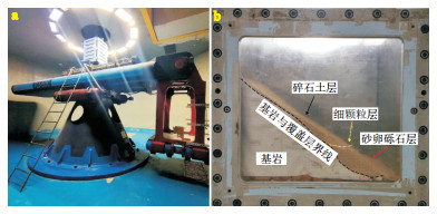
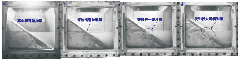
This study combines extensive geological surveys and physical mechanics experiments to investigate the potential instability and failure modes of RS accumulation under reservoir filling. On this basis, a three-dimensional numerical model of the entire river channel from the RS accumlation to the dam section was established. An analysis of the dynamic evolution of landslide-wave chain disasters caused by RS accumulation was conducted, and parameters such as the initial wave height, wave height along the opposite bank, propagation characteristics, wave height at the dam front, and wave height climbing along the dam were predicted.
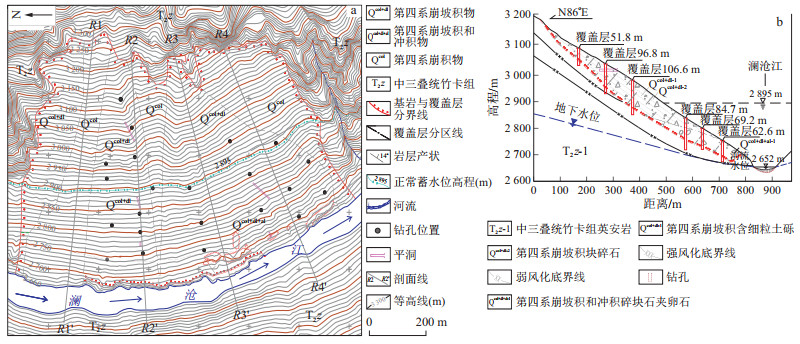
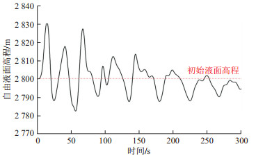
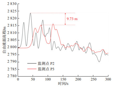
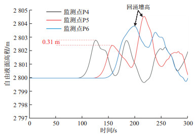
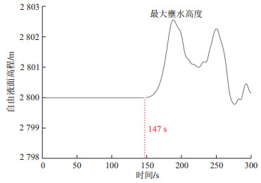
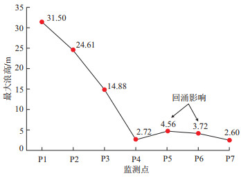
The results indicate that as the reservoir water level is gradually elevated to an altitude of 2 800 meters, the RS accumulation is most likely to undergo a large-scale instability failure. The rear tensile fracture boundary is the crushed stone and soil layer of the accumulation within a certain range above the reservoir water level, and the front shear boundary is the fine-grained layer in the middle and lower parts of the accumulation. After the instability failure of the accumulation, it induces a landslide-induced wave. The height of the first wave peaks near the water entry point, approximately 31.5 meters, and lasts for about 15 seconds. As the wave propagates downstream, the wave height decreases by 39.5% at the No. 1 river bay, reaching the dam in approximately 147 s and continuing to climb along the dam slope. The climbing wave height is approximately 2.6 m and lasts for 180 s, with no risk of overtopping by the initial or subsequent smaller waves. After being impeded by the dam, the initial wave propagates upstream, creating a backflow phenomenon, which, combined with subsequent waves, forms a locally high wave area. At monitoring point P5, the maximum backflow wave height reaches approximately 4.56 m and lasts for 219 s.
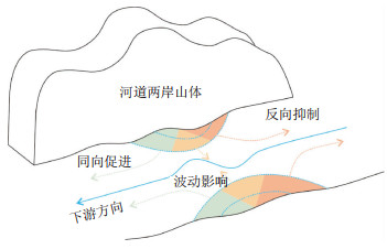
During the wave propagation process, the topography of the river bay and backflow phenomena significantly accelerate the energy dissipation of the waves, effectively reducing the risk of wave impact and secondary disasters.

| [1] |
黄润秋. 20世纪以来中国的大型滑坡及其发生机制[J]. 岩石力学与工程学报, 2007, 26(3): 433-454.
HUANG R Q. Large-scale landslides and their sliding mechanisms in China since the 20th Century[J]. Chinese Journal of Rock Mechanics and Engineering, 2007, 26(3): 433-454. (in Chinese with English abstract)
|
| [2] |
湛正刚, 程瑞林, 孙卫, 等. 水库区大型堆积体灾变分析及对策研究[J]. 岩土工程学报, 2022, 44(1): 194-200.
ZHAN Z G, CHENG R L, SUN W, et al. Disaster analysis and countermeasures of large accumulation in reservoir areas[J]. Chinese Journal of Geotechnical Engineering, 2022, 44(1): 194-200. (in Chinese with English abstract)
|
| [3] |
周定义, 左小清, 喜文飞, 等. 基于SBAS-InSAR技术的深切割高山峡谷区滑坡灾害早期识别[J]. 中国地质灾害与防治学报, 2022, 33(2): 16-24.
ZHOU D Y, ZUO X Q, XI W F, et al. Early identification of landslide hazards in deep cut alpine canyon using SBAS-InSAR technology[J]. The Chinese Journal of Geological Hazard and Control, 2022, 33(2): 16-24. (in Chinese with English abstract)
|
| [4] |
钟立勋. 意大利瓦依昂水库滑坡事件的启示[J]. 中国地质灾害与防治学报, 1994, 5(2): 77-84.
ZHONG L X. Enlightenments from the accident of Vaiont landslide in Italy[J]. The Chinese Journal of Geological Hazard and Control, 1994, 5(2): 77-84. (in Chinese with English abstract)
|
| [5] |
ROBERTS N J, MCKILLOP R J, LAWRENCE M S, et al. Impacts of the 2007 landslide-generated tsunami in Chehalis Lake, Canada[M]//MARGOTTINI C, CANUTI P, SASSA K. Landslide science and practice. Berlin, Heidelberg: Springer, 2013: 133-140.
|
| [6] |
ROBERTS N J, MCKILLOP R, HERMANNS R L, et al. Preliminary global catalogue of displacement waves from subaerial landslides[M]//SASSA K, CANUTI P, YIN Y P. Landslide science for a safer geoenvironment. Cham: Springer International Publishing, 2014: 687-692.
|
| [7] |
PARIS A, OKAL A E, GUÉRIN C, et al. Numerical modeling of the June 17, 2017 landslide and tsunami events in Karrat Fjord, West Greenland[J]. Pure and Applied Geophysics, 2019, 176(7): 3035-3057. doi: 10.1007/s00024-019-02123-5
|
| [8] |
肖莉丽, 王佳佳, 李枝强, 等. 考虑滑体-水体相互作用的滑坡涌浪产生过程动力学模型研究[J]. 岩石力学与工程学报, 2022, 41(12): 2404-2416.
XIAO L L, WANG J J, LI Z Q, et al. Research on dynamic models of landslide tsunami generation considering slide/water interactions[J]. Chinese Journal of Rock Mechanics and Engineering, 2022, 41(12): 2404-2416. (in Chinese with English abstract)
|
| [9] |
MOHAMMED F, FRITZ H M. Physical modeling of tsunamis generated by three-dimensional deformable granular landslides[J]. Journal of Geophysical Research-Oceans, 2012, 117: C11015.
|
| [10] |
汪洋, 殷坤龙. 水库库岸滑坡涌浪的传播与爬高研究[J]. 岩土力学, 2008, 29(4): 1031-1034.
WANG Y, YIN K L. Research on propagat and climb height of surge triggered by landslide in reservoir[J]. Rock and Soil Mechanics, 2008, 29(4): 1031-1034. (in Chinese with English abstract)
|
| [11] |
GYLFADÓTTIR S S, KIM J, HELGASON J K, et al. The 2014 Lake Askja rockslide-induced tsunami: Optimization of numerical tsunami model using observed data[J]. Journal of Geophysical Research(Oceans), 2017, 122(5): 4110-4122.
|
| [12] |
徐文杰. 滑坡涌浪流-固耦合分析方法与应用[J]. 岩石力学与工程学报, 2020, 39(7): 1420-1433.
XU W J. Fluid-solid coupling method of landslide tsunamis and its application[J]. Chinese Journal of Rock Mechanics and Engineering, 2020, 39(7): 1420-1433. (in Chinese with English abstract)
|
| [13] |
李东阳, 年廷凯, 吴昊, 等. 滑坡-堵江-涌浪灾害链模拟的DEM-CFD耦合分析方法及其应用[J]. 工程科学与技术, 2023, 55(1): 141-149.
LI D Y, NIAN T K, WU H, et al. Coupled DEM-CFD method for landslide-river blockage-impulse wave disaster chain simulation and its application[J]. Advanced Engineering Sciences, 2023, 55(1): 141-149. (in Chinese with English abstract)
|
| [14] |
谢媛华, 张国伟, 曹宗伟, 等. 三峡库区白水河滑坡位移与裂缝分形特征[J]. 地质科技通报, 2024, 43(4): 244-251. doi: 10.19509/j.cnki.dzkq.tb20230166
XIE Y H, ZHANG G W, CAO Z W, et al. fractal characteristics of displacement and cracks of Baishuihe landslide in the Three Gorges Reservoir area[J]. Bulletin of Geological Science and Technology, 2024, 43(4): 244-251. (in Chinese with English abstract) doi: 10.19509/j.cnki.dzkq.tb20230166
|
| [15] |
殷坤龙, 张宇, 汪洋. 水库滑坡涌浪风险研究现状和灾害链风险管控实践[J]. 地质科技通报, 2022, 41(2): 1-12. doi: 10.19509/j.cnki.dzkq.2022.0064
YIN K L, ZHANG Y, WANG Y. A review of landslide-generated waves risk and practice of management of hazard chain risk from reservoir landslide[J]. Bulletin of Geological Science and Technology, 2022, 41(2): 1-12. (in Chinese with English abstract) doi: 10.19509/j.cnki.dzkq.2022.0064
|
| [16] |
刘威, 杨宗佶, 游勇, 等. 滑坡涌浪诱发冰湖溃决灾害链过程分析与模拟[J]. 工程科学与技术, 2022, 54(2): 41-48.
LIU W, YANG Z J, YOU Y, et al. Dynamic analysis and numerical simulation of disaster chain from landslide, surge wave to glacier lake outburst[J]. Advanced Engineering Sciences, 2022, 54(2): 41-48. (in Chinese with English abstract)
|
| [17] |
罗超鹏, 常鸣, 武彬彬, 等. 基于FLOW-3D的泥石流龙头运动过程模拟研究[J]. 中国地质灾害与防治学报, 2022, 33(6): 53-62.
LUO C P, CHANG M, WU B B, et al. Simulation of debris flow head movement process in mountainous area based on FLOW-3D[J]. The Chinese Journal of Geological Hazard and Control, 2022, 33(6): 53-62. (in Chinese with English abstract)
|
| [18] |
胡大儒, 肖万春, 王晓朋, 等. 澜沧江某巨型堆积体蓄水失稳模式预测研究[J]. 水利与建筑工程学报, 2020, 18(5): 137-142.
HU D R, XIAO W C, WANG X P, et al. Prediction of instability model during impoundment period of a giant deposit in Lantsang River[J]. Journal of Water Resources and Architectural Engineering, 2020, 18(5): 137-142. (in Chinese with English abstract)
|
| [19] |
WU S Y, HU D R, WEN T. Special characteristics and stability analysis of bank slope deposits with special geotechnical structures in high and cold valleys[J]. Sustainability, 2023, 15(7): 6090. doi: 10.3390/su15076090
|
| [20] |
周鑫. 金沙江上游茂顶河段滑坡成因机制及敏感性研究[D]. 长春: 吉林大学, 2019.
ZHOU X. The mechanism analysis and susceptibility mapping of the landslides along the Maoding River at the upstream of the Jinsha River[D]. Changchun: Jilin University, 2019. (in Chinese with English abstract)
|
| [21] |
许强. 滑坡的变形破坏行为与内在机理[J]. 工程地质学报, 2012, 20(2): 145-151.
XU Q. Theoretical studies on prediction of landslides using slope deformation process data[J]. Journal of Engineering Geology, 2012, 20(2): 145-151. (in Chinese with English abstract)
|
| [22] |
王海. 土工离心模型试验技术若干关键问题研究[D]. 北京: 中国地震局工程力学研究所, 2019.
WANG H. Research on several crucial problems of geotechnical centrifuge modeling techniques[D]. Beijing: Institute of Engineering Mechanics, China Earthquake Administration, 2019. (in Chinese with English abstract)
|
| [23] |
郭长宝, 张永双, 刘定涛, 等. 基于离心机模型试验的甘肃江顶崖古滑坡复活机理研究[J]. 工程地质学报, 2022, 30(1): 164-176.
GUO C B, ZHANG Y S, LIU D T, et al. Centrifuge model test of reactivation mechanism of Jiangdingya ancient landslide in Gansu Province[J]. Journal of Engineering Geology, 2022, 30(1): 164-176. (in Chinese with English abstract)
|
| [24] |
魏迎奇, 张雪东, 张紫涛, 等. 基于LXJ-4-450平台的土工离心模型试验研究[J]. 水利学报, 2018, 49(9): 1087-1096.
WEI Y Q, ZHANG X D, ZHANG Z T, et al. Geotechnical centrifuge modelling based on LXJ-4-450 platform[J]. Journal of Hydraulic Engineering, 2018, 49(9): 1087-1096. (in Chinese with English abstract)
|
| [25] |
ZHAO K, XU Q, LIU F, et al. Centrifuge modeling of loess slope failure induced by rising water level utilizing intact sample[J]. Engineering Failure Analysis, 2024, 163: 108572-108572. doi: 10.1016/j.engfailanal.2024.108572
|
| [26] |
SAAD Y, SCHULTZ M H. GMRES: A generalized minimal residual algorithm for solving nonsymmetric linear systems[J]. SIAM Journal on Scientific and Statistical Computing, 1986, 7(3): 856-869. doi: 10.1137/0907058
|
| [27] |
DE CARVALHO R F, DO CARMO J S A. Landslides into reservoirs and their impact on banks[J]. Environmental Fluid Mechanics, 2007, 7(6): 481-493. doi: 10.1007/s10652-007-9039-2
|
| [28] |
AJMANI K, NG W F, LIOU M S. Preconditioned conjugate gradient methods for the navier-stokes equations[J]. Journal of Computational Physics, 1994, 110(1): 68-81. doi: 10.1006/jcph.1994.1006
|
| [29] |
LUO H, BAUM J D, LÖHNER R. A fast, matrix-free implicit method for compressible flows on unstructured grids[J]. Journal of Computational Physics, 1998, 146(2): 664-690. doi: 10.1006/jcph.1998.6076
|
| [30] |
HELLER V, HAGER W H. Impulse product parameter in landslide generated impulse waves[J]. Journal of Waterway, Port, Coastal, and Ocean Engineering, 2010, 136(3): 145-155. doi: 10.1061/(ASCE)WW.1943-5460.0000037
|
| [31] |
周桂云, 李同春, 钱七虎. 水库滑坡涌浪传播有限元数值模拟[J]. 岩土力学, 2013, 34(4): 1197-1201.
ZHOU G Y, LI T C, QIAN Q H. Finite element numerical simulation of water waves due to reservoir landslides[J]. Rock and Soil Mechanics, 2013, 34(4): 1197-1201. (in Chinese with English abstract)
|
| [32] |
刘艺梁, 陈健翔, 高晨曦, 等. 基于滑面分区段力学模型的高速滑坡运动过程能量转化研究[J]. 地质科技通报, 2022, 41(2): 139-146. doi: 10.19509/j.cnki.dzkq.2022.0061
LIU Y L, CHEN J X, GAO C X, et al. Energy conversion of the high-speed landslide movement process based on a sliding surface partition mechanical model[J]. Bulletin of Geological Science and Technology, 2022, 41(2): 139-146. (in Chinese with English abstract) doi: 10.19509/j.cnki.dzkq.2022.0061
|
| [33] |
马鑫磊, 任光明, 夏敏. 滑坡涌浪预测评价方法综述[J]. 水利水电科技进展, 2015, 35(3): 89-98.
MA X L, REN G M, XIA M. Review on the forecast evaluation methods of landslide surge[J]. Advances in Science and Technology of Water Resources, 2015, 35(3): 89-98. (in Chinese with English abstract)
|
| [34] |
李稳哲, 岳高伟, 王辉, 等. 高速滑坡涌浪动力学机理研究[J]. 自然灾害学报, 2013, 22(5): 127-133.
LI W Z, YUE G W, WANG H, et al. Dynamic mechanism of high speed landslide surge[J]. Journal of Natural Disasters, 2013, 22(5): 127-133. (in Chinese with English abstract)
|
| [35] |
TANG G Q, LU L, TENG Y F, et al. Impulse waves generated by subaerial landslides of combined block mass and granular material[J]. Coastal Engineering, 2018, 141: 68-85.
|
| [36] |
SERRANO-PACHECO A, MURILLO J, GARCÍA-NAVARRO P. A finite volume method for the simulation of the waves generated by landslides[J]. Journal of Hydrology, 2009, 373(3/4): 273-289.
|
| [37] |
刘艺梁. 三峡库区库岸滑坡涌浪灾害研究[D]. 武汉: 中国地质大学(武汉), 2014.
LIU Y L. Research on landslide-induced surge in Three Gorges Reservoir area[D]. Wuhan: China University of Geosciences(Wuhan), 2014. (in Chinese with English abstract)
|
Copyright © 2010Editorial Department of Bulletin of Geological Science and Technology

Supported by:
Beijing Renhe Information Technology Co., Ltd.


 DownLoad: