| Citation: | Yang Peizhang, Cui Shenghua, Pei Xiangjun, He Shuang, Wang Hui, Liang Yufei. Deformation and evolution of large dumping bodies based on SBAS-InSAR and optical remote sensing images[J]. Bulletin of Geological Science and Technology, 2023, 42(6): 63-75. doi: 10.19509/j.cnki.dzkq.tb20220145

|
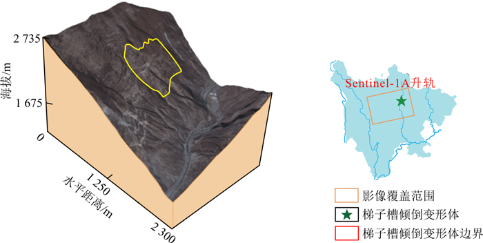
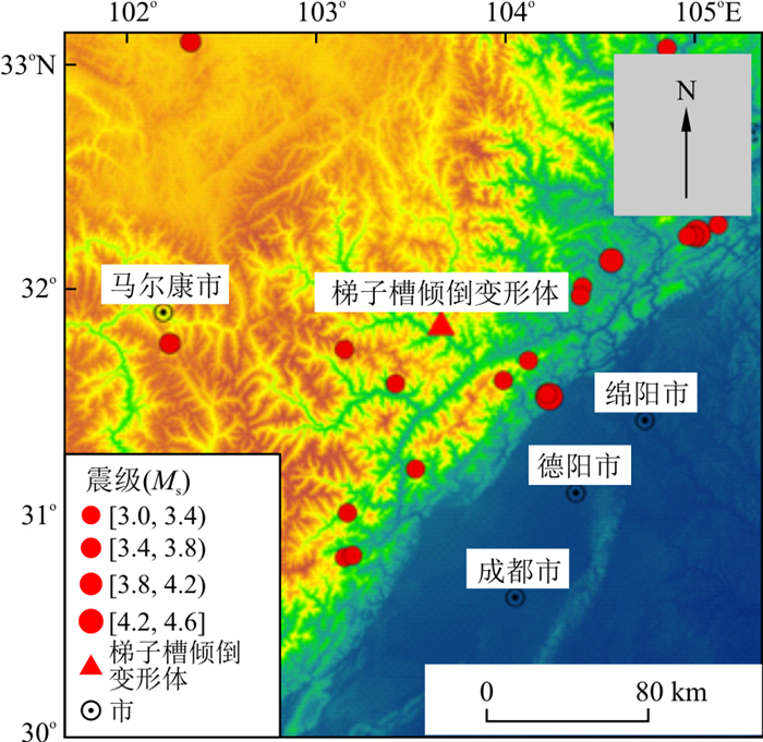
Deep unstable slopes develop in the Minjiang River Basin, and revealing their deformation evolution characteristics is of great significance for stability evaluation and disaster prevention.
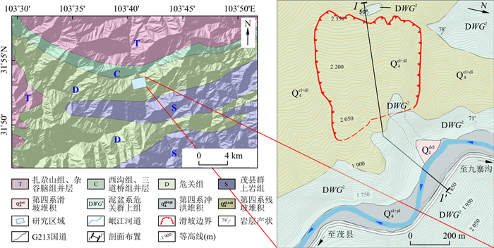
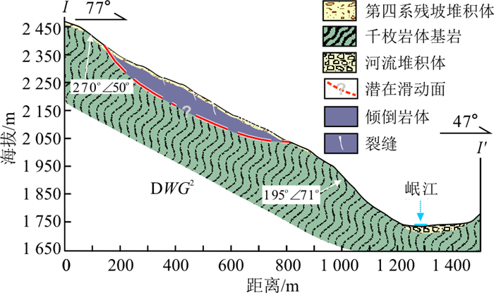
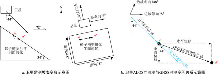
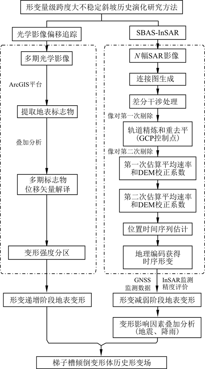
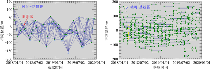
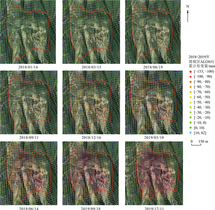
In this study, taking the large-scale dumping deformation body of the ladder slot in Maoxian as an example, and the method of combining SBAS-InSAR monitoring and optical remote sensing interpretation was used to obtain the historical time series deformation field of the deformable body surface.
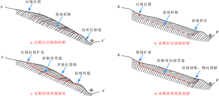
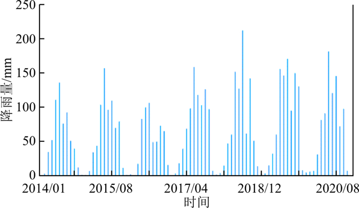
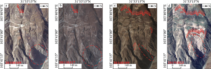
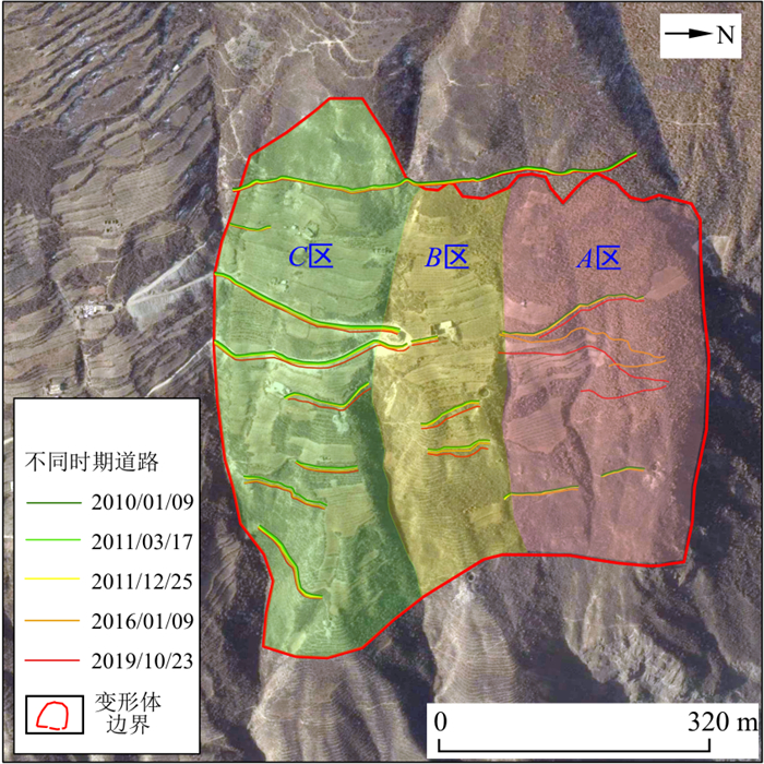
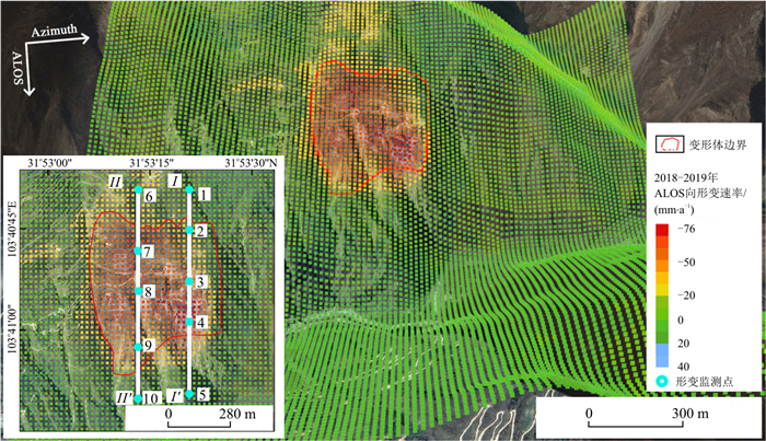
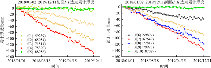
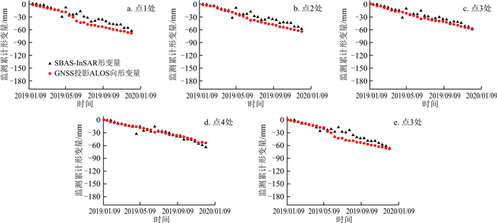
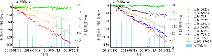
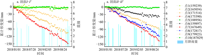
The research shows that the leading edge of the collapsed deformed body of the ladder trough exhibits a composite failure mode of collapse failure and bulging cracking, and the collapse area has experienced a failure process from increasing deformation to weakening; in the increasing stage, the deformation amount on the north side of the dump deformer is much larger than that on the south side. After the deformation weakened, a tensile stress settlement zone (-70.17 mm/a) formed on the trailing edge of the south side, and the leading edge bulged and cracked (-45.94 mm/a) due to the concentration of compressive stress. After the deformation weakened, the deformed body was in a creep state (the maximum annual settlement was less than 80 mm), but the deformation of the south trailing edge collapse area and the north leading edge collapse area responded obviously to rainfall and earthquakes, showing a sudden increase of 5-15 mm deformation and a rebound phenomenon.
The surface displacement monitoring method in this paper can provide a reference for the evolution analysis of unstable slopes with large deformation level spans.

| [1] |
Cui S H, Pei X J, Jiang Y, et al. Liquefaction within a bedding fault: Understanding the initiation and movement of the Daguangbao landslide triggered by the 2008 Wenchuan Earthquake (Ms=8.0)[J]. Engineering Geology, 2021, 295: 106455. doi: 10.1016/j.enggeo.2021.106455
|
| [2] |
黄润秋. 20世纪以来中国的大型滑坡及其发生机制[J]. 岩石力学与工程学报, 2007, 26(3): 433-454. https://www.cnki.com.cn/Article/CJFDTOTAL-YSLX200703000.htm
Huang R Q. Large-scale landslides and their sliding mechanisms in China since the 20th Century[J]. Chinese Journal of rock Mechanics and Engineering, 2007, 26(3): 433-454(in Chinese with English abstract). https://www.cnki.com.cn/Article/CJFDTOTAL-YSLX200703000.htm
|
| [3] |
崔圣华, 杨晴雯, 芮雪莲, 等. 裂隙岩体循环冻融变形特征及影响因素分析[J]. 地质科技通报, 2021, 40(6): 205-215. doi: 10.19509/j.cnki.dzkq.2021.0620
Cui S H, Yang Q W, Rui X L, et al. Effect factors analysis and characteristic of freeze-thaw deformation of fracture rock[J]. Bulletin of Geological Science and Technology, 2021, 40(6): 205-215(in Chinese with English abstract). doi: 10.19509/j.cnki.dzkq.2021.0620
|
| [4] |
许强, 董秀军, 李为乐. 基于天-空-地一体化的重大地质灾害隐患早期识别与监测预警[J]. 武汉大学学报: 信息科学版, 2019, 44(7): 957-966. https://www.cnki.com.cn/Article/CJFDTOTAL-WHCH201907002.htm
Xu Q, Dong X J, Li W L. Integrated space-air-ground early detection, monitoring and warning system for potential catastrophic geohazards[J]. Geomatics and Information Science of Wuhan University, 2019, 44(7): 957-966(in Chinese with English abstract). https://www.cnki.com.cn/Article/CJFDTOTAL-WHCH201907002.htm
|
| [5] |
何双, 崔圣华, 裴向军, 等. 基于多源数据的茂县石大关倾倒体形态结构探测与成因研究[J]. 工程地质学报, 2023, 31(3): 932-948.
He S, Cui S H, Pei X J, et al. Morphological structure and failure mechanism of Shidaguang toppling body in Maoxian based on multi-source date[J]. Journal of Engineering Geology, 2023, 31(3): 932-948(in Chinese with English abstract).
|
| [6] |
董佳慧, 牛瑞卿, 亓梦茹, 等. InSAR技术和孕灾背景指标相结合的地灾隐患识别[J]. 地质科技通报, 2022, 41(2): 187-196. doi: 10.19509/j.cnki.dzkq.2022.0024
Dong J H, Niu R Q, Qi M R, et al. Identification of geological hazards based on the combination of InSAR technology and disaster background indicators[J]. Bulletin of Geological Science and Technology, 2022, 41(2): 187-196(in Chinese with English abstract). doi: 10.19509/j.cnki.dzkq.2022.0024
|
| [7] |
郭晓丹, 查显杰, 黄金水. 利用遥感影像偏移追踪的地震滑坡监测[J]. 遥感信息, 2016, 31(3): 56-60.
Guo X D, Zha X J, Huang J S. Monitoring earthquake-triggered landslide using optical inage offset-tracking algorithm[J]. Remote Sensing Information, 2016, 31(3): 56-60(in Chinese with English abstract).
|
| [8] |
王朋伟, 安玉科. 基于倾斜摄影与InSAR技术的高位崩塌风险识别[J]. 水文地质工程地质, 2023, 50(5): 169-180. https://www.cnki.com.cn/Article/CJFDTOTAL-SWDG202305017.htm
Wang P W, An Y K. High-level collapse risk identification based on oblique photography and InSAR technology[J]. Hydrogeology & Engineering Geology, 2023, 50(5): 169-180(in Chinese with English abstract). https://www.cnki.com.cn/Article/CJFDTOTAL-SWDG202305017.htm
|
| [9] |
刘立, 李长安, 高俊华, 等. 基于北斗与InSAR的地质灾害监测关键问题探讨[J]. 地质科技情报, 2019, 38(6): 141-149.
Liu L, Li C A, Gao J H, et al. Geological disaster monitoring combined with BDS and InSAR[J]. Geological Science and Technology Information, 2019, 38(6): 141-149(in Chinese with English abstract).
|
| [10] |
朱建军, 李志伟, 胡俊. InSAR变形监测方法与研究进展[J]. 测绘学报, 2017, 46(10): 1717-1733. https://www.cnki.com.cn/Article/CJFDTOTAL-CHXB201710054.htm
Zhu J J, Li Z W, Hu J. InSAR deformation monitoring methods and research progress[J]. Acta Geodaetica et Cartographica Sinica, 2017, 46(10): 1717-1733(in Chinese with English abstract). https://www.cnki.com.cn/Article/CJFDTOTAL-CHXB201710054.htm
|
| [11] |
Li M H, Zhang L, Dong J, et al. Characterization of pre- and post-failure displacements of the Huangnibazi landslide in Li County with multi-source satellite observations[J]. Engineering Geology, 2019, 257: 105140.
|
| [12] |
韩旭东, 付杰, 李严严, 等. 舟曲江顶崖滑坡的早期判识及风险评估研究[J]. 水文地质工程地质, 2021, 48(6): 180-186. https://www.cnki.com.cn/Article/CJFDTOTAL-SWDG202106020.htm
Han X D, Fu J, Li Y Y, et al. A study of the early identification and risk assessment of the Jiangdingya landslide in Zhouqu county[J]. Hydrogeology & Engineering Geology, 2021, 48(6): 180-186(in Chinese with English abstract). https://www.cnki.com.cn/Article/CJFDTOTAL-SWDG202106020.htm
|
| [13] |
单新建, 叶洪. 干涉测量合成孔径雷达技术原理及其在测量地震形变场中的应用[J]. 地震学报, 1998, 20(6): 88-96.
Shan X J, Ye H. Principle of interferometric synthetic aperture radar technology and its application in measuring seismic deformation field[J]. Acta Seismologica Sinica, 1998, 20(6): 88-96(in Chinese with English abstract).
|
| [14] |
范青松, 汤翠莲, 陈于, 等. GPS与InSAR技术在滑坡监测中的应用研究[J]. 测绘科学, 2006, 31(5): 60-62.
Fan Q S, Tang C L, Cheng Y, et al. Application of GPS and InSAR technology in landslide monitoring[J]. Science of Surveying and Mapping, 2006, 31(5): 60-62(in Chinese with English abstract).
|
| [15] |
张路, 廖明生, 董杰, 等. 基于时间序列InSAR分析的西部山区滑坡灾害隐患早期识别: 以四川丹巴为例[J]. 武汉大学学报: 信息科学版, 2018, 43(12): 2039-2049. https://www.cnki.com.cn/Article/CJFDTOTAL-WHCH201812031.htm
Zhang L, Liao M S, Dong J, et al. Early detection of landslide hazards in mountainous areas of west China using time series SAR interferometry: A case study of Danba, Sichuan[J]. Geomatics and Information Science of Wuhan University, 2018, 43(12): 2039-2049(in Chinese with English abstract). https://www.cnki.com.cn/Article/CJFDTOTAL-WHCH201812031.htm
|
| [16] |
解明礼, 赵建军, 巨能攀, 等. 多源数据滑坡时空演化规律研究: 以黄泥坝子滑坡为例[J]. 武汉大学学报: 信息科学版, 2020, 45(6): 923-932. https://www.cnki.com.cn/Article/CJFDTOTAL-WHCH202006016.htm
Jie M L, Zhao J J, Ju N P, et al. Research on temporal and spatial evolution of landslide based on multisource date: A case study of Huangnibazi landslide[J]. Geomatics and Information Science of Wuhan University, 2020, 45(6): 923-932(in Chinese with English abstract). https://www.cnki.com.cn/Article/CJFDTOTAL-WHCH202006016.htm
|
| [17] |
赵超英, 刘晓杰, 张勤, 等. 甘肃黑方台黄土滑坡InSAR识别、监测与失稳模式研究[J]. 武汉大学学报: 信息科学版, 2019, 44(7): 996-1007. https://www.cnki.com.cn/Article/CJFDTOTAL-WHCH201907005.htm
Zhao C Y, Liu X J, Zhang Q, et al. Research on loess landslide identification, monitoring and failure mode with InSAR technique in Heifangtai, Gansu[J]. Geomatics and Information Science of Wuhan University, 2019, 44(7): 996-1007(in Chinese with English abstract). https://www.cnki.com.cn/Article/CJFDTOTAL-WHCH201907005.htm
|
| [18] |
冯文凯, 顿佳伟, 易小宇, 等. 基于SBAS-InSAR技术的金沙江流域沃达村巨型老滑坡形变分析[J]. 工程地质学报, 2020, 28(2): 384-393.
Feng W K, Dun J W, Yi X Y, et al. Deformation analysis of Woda Village old landslide in Jinsha River basin using SBAS-InSAR technology[J]. Journal of Engineering Geology, 2020, 28(2): 384-393(in Chinese with English abstract).
|
| [19] |
陆会燕, 李为乐, 许强, 等. 光学遥感与InSAR结合的金沙江白格滑坡上下游滑坡隐患早期识别[J]. 武汉大学学报: 信息科学版, 2019, 44(9): 1342-1354.
Lu H Y, Li W L, Xu Q, et al. Early detection of landslides in the upstream and downstream areas of the Baige landslide, the Jinsha River based on optical remote sensing and InSAR technologies[J]. Geomatics and Information Science of Wuhan University, 2019, 44(9): 1342-1354(in Chinese with English abstract).
|
| [20] |
钟灵毓, 薛武, 王鹏. 光学遥感影像几何校正方法分析[J]. 北京测绘, 2020, 34(9): 1271-1275.
Zhong L Y, Xue W, Wang P. Analysis of optical remote sensing image geometric rectification[J]. Beijing Surveying and Mapping, 2020, 34(9): 1271-1275(in Chinese with English abstract).
|
| [21] |
许强, 郑光, 李为乐, 等. 2018年10月和11月金沙江白格两次滑坡-堰塞堵江事件分析研究[J]. 工程地质学报, 2018, 26(6): 1534-1551.
Xu Q, Zheng G, Li W L, et al. Study on successive landslide damming events of Jinsha River in Baige Village on October 11 and November 3, 2018[J]. Journal of Engineering Geology, 2018, 26(6): 1534-1551(in Chinese with English abstract).
|
| [22] |
Cenni N, Fiaschi S, Fabris M. Integrated use of archival aerial photogrammetry, GNSS, and InSAR data for the monitoring of the Patigno landslide (Northern Apennines, Italy)[J]. Landslides, 2021, 18(6): 2247-2263.
|
| [23] |
黄润秋, 李渝生, 严明. 斜坡倾倒变形的工程地质分析[J]. 工程地质学报, 2017, 25(5): 1165-1181.
Huang R Q, Li Y S, Yan M. The implication and evaluation of toppling failure in engineering geology practice[J]. Journal of Engineering Geology, 2017, 25(5): 1165-1181(in Chinese with English abstract).
|
| [24] |
Xie M L, Zhao W H, Ju N P, et al. Landslide evolution assessment based on InSAR and real-time monitoring of a large reactivated landslide, Wenchuan, China[J]. Engineering Geology, 2020, 277: 105781.
|
| [25] |
汪超. 地震影响场及烈度衰减关系研究[D]. 成都: 西南交通大学, 2014.
Wang C. The research of seismic influence filed and intensity attenaution[D]. Chengdu: Southwest Jiaotong University, 2014(in Chinese with English abstract).
|
| [26] |
崔圣华. 强震过程软弱层带地震动响应及大型滑坡启动机制研究[J]. 岩石力学与工程学报, 2018, 37(6): 1560. https://www.cnki.com.cn/Article/CJFDTOTAL-YSLX201806025.htm
Cui S H. Seismic responses of wake interlayer and initiation mechanisms of large landslides during strong earthquake[J]. Chinese Journal of Rock Mechanics and Engineering, 2018, 37(6): 1560(in Chinese with English abstract). https://www.cnki.com.cn/Article/CJFDTOTAL-YSLX201806025.htm
|
Copyright © 2010Editorial Department of Bulletin of Geological Science and Technology

Supported by:
Beijing Renhe Information Technology Co., Ltd.


 DownLoad: