2023 Vol. 42, No. 6

Display Method:
Assessment of the water-sealed safety of underground crude oil storage based on a three-dimensional refined numerical model
Jing Shaodong, Xu Guohui, Wu Shangbin, Liu Xiaozhong, Li Zhihua, Liu Qianling, Liu Kangneng, Zhang Bin
2023, 42(6): 1-11. doi: 10.19509/j.cnki.dzkq.tb20220097
Abstract:
Objective

The principle of a "gap storage water seal" is used to realize large-scale underground storage of crude oil, in which water-sealed safety is an important prerequisite for the safe and economical operation of underground oil storage.

Methods

To evaluate the water-sealed safety of underground oil storage, based on a refined engineering geological survey, the permeability coefficients of cavern surrounding rock, fault zones, dense joint fracture zones, and broken zones are obtained accurately, and the spatial variation of the permeability coefficient within the reservoir area is comprehensively analysed. Combined with multi-source high-precision survey information, a three-dimensional refined seepage numerical simulation model is constructed. After comparing and analysing both advantages and disadvantages of the three-dimensional refined model and corresponding homogeneous medium model, a numerical simulation is carried out to compare and analyse the reliability of cave storage with or without a water seal, and the water inflow of cavern during construction and operation is also predicted.

Results

Results show that the three-dimensional refined model can accurately reflect the influence of geological structures on the groundwater level and water pressure, making analysis more in line with the real situation.The water curtain system can effectively improve the water-sealed safety of underground oil storage. Specifically, when the cavern is excavated without water curtain, the groundwater level drops significantly, and drainage area exists above some caverns. When the cavern is excavated under water curtain, the groundwater level does not drop significantly, and thick aquifer exists above the cavern, ensuring the water-sealed safety of underground oil storage; at the same time, the water inflow of cavern is under control.

Conclusion

Assessment of the water-sealed safety of underground crude oil storage provided in this article can be used as a reference for other similar projects.

Prediction model and variation law of P-wave velocity of single fracture granite in an underground water-sealed storage cavern
Cao Yangbing, Wu Yang, Zhang Peng, Jiang Zhihao, Zhang Siyi, Huang Zhenping
2023, 42(6): 12-20. doi: 10.19509/j.cnki.dzkq.tb20220279
Abstract:
Objective

Revealing the variation behavior of P-wave velocity in fractured rock masses is of great significance for the quality grading and stability evaluation of rock masses for engineering purposes.

Methods

The nonfilling single fracture granite of an under ground water sealed storage cavern was taken as the research object. Based on borehole television images, hydraulic fracturing geostress tests, and ultrasonic full waveform logging, the geometric characteristics, stress state, and P-wave velocity of 384 groups of single fracture granites were obtained. An evolutionary neural network model for the prediction of the P-wave velocity of granite with a single fracture was constructed, and the variation behavior of the key indexes affecting the P-wave velocity of granite with a single fracture was analyzed.

Results

The study shows that the P-wave velocity of a single fracture granite in the water-sealed storage cavern is distributed around 4 300-5 330 m/s, and 82.3% of the P-wave velocity varies within 4 700-5 200 m/s. It is reasonable and feasible to select the fracture normal stress, average aperture, and dip angle as prediction indexes of the P-wave velocity of granite with a single fracture. The field test data sets are divided into training samples and test samples. The P-wave velocity prediction model of granite with a single fracture, based on the evolutionary neural network model, is constructed. The neural network weight and threshold are optimized by the genetic algorithm.The maximum test error of the prediction model is only 2.9%, and the test error of 85% of the samples is less than 1.5%.The prediction model thus yields high accuracy.

Conclusion

The variation feature of the P-wave velocity revealed that the P-wave velocity of granite with a single fracture increases with increasing normal stress on the fracture. However, the increase in the P-wave velocity decreases gradually when the normal stress increases to 5 MPa. The P-wave velocity decreases with an increasing fracture aperture. The P-wave velocity increases with an increasing dip angle. However, no difference occurred considering that the fracture dip angle is less than 40°.

Rapid identification method for the dangerous rock mass of a high-steep slope based on UAV LiDAR and ground imitation flight
Pang Xin, Yuan Ming, Lu Yuan, Du Wenjie, Wan Daochun, Li De, Ding Haifeng, Fu Xiaodong
2023, 42(6): 21-30. doi: 10.19509/j.cnki.dzkq.tb20220427
Abstract:
Objective

In Southwest China, rockfall hazards are extremely developed in high mountains and deep valley areas with high and steep slopes. Due to the large elevation difference and steep slope, the dangerous rock mass on a high-steep slope has remarkable characteristics of suddenness. Thus, a rapid, accurate and convenient interpretation and identification for the source of dangerous rock mass becomes the primary problem of risk analysis of high-steep slopes. At present, the progress of detection makes image-based geological hazard interpretation gradually develop from visual identification to human-computer interactive identification. Among them, the UAV LiDAR system is widely used in geological disaster investigation by integrating both advantages of UAV carrier and LiDAR measurement technology, while the introduction of ground imitation flight technology can make the UAV LiDAR system adapt to complex terrain, obtaining high-precision and high-density point cloud data.

Methods

On this basis, a UAV survey was carried out on the East side slope of open-pit mine, and a high-precision DOM image and 3D point cloud model were obtained by processing the UAV survey data. As the supplementary materials of the DOM image, the geometric feature parameters of outcrop, including surface roughness and dip, are quantitatively extracted from the point cloud model. On this basis, a set of human-computer interactive identification for dangerous rock masses based on DOM images and geometric features is proposed.

Results

The application to the East side slope of open-pit mine shows that by superimposing outcrop slope geometric features based on DOM images, the proposed human-computer interactive identification method can significantly improve the efficiency and accuracy of identification, and the identification of overhanging dangerous rock mass is much more robust than visual ones.

Conclusion

By combining innovative remote sensing technologies, the proposed method provides a fast and convenient solution for the identification of dangerous rock masses on high and steep rocky slopes.

Intelligent recognition and quantitative analysis of borehole hydraulic geological images utilizing multiple deep learning models
Zhang Ye, Chen Jinqiao, Li Yanlong
2023, 42(6): 31-41. doi: 10.19509/j.cnki.dzkq.tb20220091
Abstract:
Objective

Borehole Televiewer (BHTV) imaging serves as an effective tool for analyzing deep rock formations in geological engineering, offering crucial insights into surface discontinuity extensions and the distribution of buried discontinuities, especially within complex geological environments associated with hydraulic engineering projects. Recognizing the current issues of subjectivity and low efficiency, prevalent in the manual calculation of rock discontinuity morphological characteristics within rock masses, we propose an intelligent approach for segmenting geometric data from digital borehole images. Leveraging the segmentation outcomes, an image thinning technique is employed to facilitate precise quantitative analysis of borehole data.

Methods

In this research, we employ deep learning models to intelligently identify fractures within BHTV images, utilizing various network structures such as Unet, SegNet, and DeepLabV3. The recognition results are compared with traditional image processing methods, demonstrating the advantages of deep models in accurately segmenting complex geological images. Furthermore, we enhance the model's performance by incorporating an attention mechanism into the encoder-decoder process.Once precise segmentation of rock discontinuities is achieved, the fracture skeleton is extracted using the image thinning method, representing fractures as one-pixel-width curves. Ultimately, automated calculations is completed for dip strike, dip angle, and fracture thickness.

Results

This method is applied to segment and calculate borehole televiewer images in hydraulic engineering. Comparing the results of manual extraction and automatic extraction of fracture information, the error of dip strike and dip angle is less than 3°, and the fracture thickness error is less than 0.65 mm.

Conclusion

The results verify that the intelligent calculation method of fracture information proposed in this paper. The proposed method has wide application prospects in hydraulic engineering.

Application of a small-scale model test in distinguishing of water inrush in the Wufeng Tunnel
Xu Xiaochuan, Xu Guangli, Lin Gaowei, Li Yiyuan, Ma Yun
2023, 42(6): 42-52. doi: 10.19509/j.cnki.dzkq.2022.0149
Abstract:
Objective

Water inrush in karst tunnel has a great influence on tunnel safety.

Methods

Taking the Wufeng Tunnel of Yilai Expressway as the research object, the risk of water inrush in the tunnel was identified though field hydrogeological investigation, borehole water level and indoor rainfall monitoring, numerical simulation and small-scale model tests.

Results

The test results show that the risk of water inrush in the tunnel is mainly affected by the relative spatial position between the karst pipeline and tunnel, including the water pressure of the pipeline. The influence of seepage on the tunnel can be effectively reduced by increasing the thickness of the overlying soil when the test water pressure is 0.2 MPa. But with the increase in water pressure, the seepage of pipeline water is not only vertical seepage but also includes horizontal seepage. The intermittent cracks in the waterproof layer expand, which finally results in water inrush damage in the tunnel. The numerical simulation results show that the maximum shear force of the Wufeng Tunnel is at the arc and shoulder, which may easily form tensile shear failure along this part under groundwater seepage. The finding is consistent with the test results of the small-scale model. The water inrush in the tunnel is the coupling effect of the shear force and seepage field.

Conclusion

The primary factor of water inrush in the tunnel is water pressure and is closely related to the thickness of water barrier rock.

A quantitative evaluation method regarding the natural void ratio of undisturbed loess
Gao Zhihui, Zuo Lu
2023, 42(6): 53-62. doi: 10.19509/j.cnki.dzkq.tb20220172
Abstract:
Objective

The natural void ratio is the most frequently used and important characterisation parameter of the initial structure at the macroscopic level. Therefore, the analysis and prediction of the distribution pattern of the natural void ratio of loess is important for understanding undisturbed loess disaster mechanics behaviour and for disaster early warning from the geotechnical point of view.

Methods

In this study, particle analysis tests, XRD tests, natural void ratio tests and 1D consolidation tests were carried out on in situ soil samples from different layers of a typical loess site to analyse the correlation between the natural void ratio and particle fraction and stress history. The results show that the natural void ratio can be affected by the stress history and particle size distribution. The higher the overburden pressure is, the more uniform the grading is and the smaller the natural pore ratio is. The water content may be one of the reasons for the variation in the natural void ratio.

Results

On this basis, the burial depth of the layer, the inhomogeneous coefficient and curvature coefficient of particle gradation, and the natural water content are selected as the influencing factors, and the natural void ratio is evaluated quantitatively based on the machine learning algorithm. The SSA and PSO algorithm were introduced to optimise the weights and thresholds of the BP neural network, and natural void ratio predicted models based on the BP, SSA-BP and PSO-BP neural networks were established. The trained BP, SSA-BP and PSO-BP neural network models were then used to predict 16 sets of validation and test data, and the predicted results were compared with the measured natural void ratios.

Conclusion

The results show that the PSO-BP-based neural network model predicts significantly better than the SSA-BP and BP neural network models, and can effectively predict the natural void ratio.

Deformation and evolution of large dumping bodies based on SBAS-InSAR and optical remote sensing images
Yang Peizhang, Cui Shenghua, Pei Xiangjun, He Shuang, Wang Hui, Liang Yufei
2023, 42(6): 63-75. doi: 10.19509/j.cnki.dzkq.tb20220145
Abstract:
Objective

Deep unstable slopes develop in the Minjiang River Basin, and revealing their deformation evolution characteristics is of great significance for stability evaluation and disaster prevention.

Methods

In this study, taking the large-scale dumping deformation body of the ladder slot in Maoxian as an example, and the method of combining SBAS-InSAR monitoring and optical remote sensing interpretation was used to obtain the historical time series deformation field of the deformable body surface.

Results

The research shows that the leading edge of the collapsed deformed body of the ladder trough exhibits a composite failure mode of collapse failure and bulging cracking, and the collapse area has experienced a failure process from increasing deformation to weakening; in the increasing stage, the deformation amount on the north side of the dump deformer is much larger than that on the south side. After the deformation weakened, a tensile stress settlement zone (-70.17 mm/a) formed on the trailing edge of the south side, and the leading edge bulged and cracked (-45.94 mm/a) due to the concentration of compressive stress. After the deformation weakened, the deformed body was in a creep state (the maximum annual settlement was less than 80 mm), but the deformation of the south trailing edge collapse area and the north leading edge collapse area responded obviously to rainfall and earthquakes, showing a sudden increase of 5-15 mm deformation and a rebound phenomenon.

Conclusion

The surface displacement monitoring method in this paper can provide a reference for the evolution analysis of unstable slopes with large deformation level spans.

Effect of shrinkage characteristics of bentonite with different sand mixing rates and dry densities
Ma Hongfa, Liu Qingbing, Li Jing
2023, 42(6): 76-85. doi: 10.19509/j.cnki.dzkq.tb20220099
Abstract:
Objective

Bentonite is a special soil with obvious expansion and shrinkage, and its strength change caused by shrinkage, accompanied by the formation of fissure has significant impact on the safety of engineering structures.Thereby, investigation on the shrinkage of bentonite is of great importance to engineering safety.

Methods

By carrying out the drying shrinkage test under constant temperature, combined with digital image technology, the effects of dry density and sand mixing rate on water evaporation, anisotropic strain and fissure during the drying shrinkage process of soil were studied.

Results

The results showed that the drying shrinkage process of the soil can be divided into deceleration stage and residual stages. During shrinkage process, the higher the dry density and sand content ratio in soil sample, the less the water loss, the smaller the strain in each direction and the fewer the fissure created. The soil microstructure observed by scanning electron microscopy showed that the higher the dry density and sand content ratio, the more uniform and dense the soil microstructure, and the less the pores in soil. According to the selection of the soil sample shrinkage characteristic model, the T&D model has a better data fitting effect.

Conclusion

Experimental results evidence that increasing the sand addition rate and dry density is an effective means to reduce the shrinkage of bentonite.

Dispersion potential of asphaltene in live oil by nanoparticles
Zhan Zhuanying, Ni Jun
2023, 42(6): 86-94. doi: 10.19509/j.cnki.dzkq.tb20220226
Abstract:
Objective

In order to clarify the effect and mechanism of nanoparticles on inhibiting asphaltene precipitation in formation live oil formation under high temperature and high pressure.

Methods

In this study, by carrying out high-temperature and high-pressure solid particle detection experiment, the aggregation and precipitation characteristics of asphaltene in formation live oil under the action of SiO2 and Co3O4 nanoparticles were studied by means of laser detection, high-pressure microscopy and high-temperature and high-pressure filtration. Combined with the electron microscope scanning and thermogravimetric analysis experiments, the mechanism of nanoparticles inhibiting asphaltene precipitation was revealed.

Results

The results show that the initial pressure of asphaltene precipitation (AOP) decreases from 59.2 MPa to 53.4 MPa after adding SiO2 nanoparticles to the crude oil of the target reservoir.When the pressure was reduced to 35 MPa, the average particle size of asphaltene particles decreases from 8.82 μm to 5.53 μm, and the proportion of precipitation decreased from 66.4% to 46.4%. After adding Co3O4 nanoparticles, there is no obvious asphaltene precipitation above the bubble point pressure.The average particle size of asphaltene particles is only 1.65 μm under 35 MPa pressure, and the proportion of precipitation is only 13.6%. Nanoparticles can inhibit the precipitation of asphaltene molecules, slow down the aggregation rate of asphaltene particles, and reduce AOP and precipitation. Compared with SiO2, Co3O4 nanoparticles have higher asphaltene adsorption affinity and better inhibition effect.

Conclusion

The research results provide a basis for preventing asphaltene deposition and improving deposition damage.

Sedimentary evolution revealed by aeolian and lacustrine depositions in the southern margin of the Weihe Basin during the Early Pleistocene
Wang Ting, Zhang Hang, Sun Youbin
2023, 42(6): 95-105. doi: 10.19509/j.cnki.dzkq.tb20220111
Abstract:
<p>The Quaternary climate is characterized by a notable cooling and significant glacial-interglacial fluctuations driven by the influence of orbital-induced insolation and bipolar ice-volume variability. The Weihe Basin, located in the critical zone of the Asian monsoon region, accumulated thick fluvial-lacustrine deposition and aeolian deposition since the Cenozoic, which is a key placeto explore the environmental evolution during the Quaternary period.</p></sec><sec><title>Objective

The fluvial-lacustrine strata of the Sanmen Formation in the Weihe Basin are considered to be closely related to Palaeo-Sanmen Lake. However, the relationship among the stratigraphic age of the Sanmen Formation, the evolution of the palaeolake as well as the evolution of regional tectonics is still under much debated.

Methods

In this work, the magnetic susceptibility and grain size records from two sections (Yanyu and Wujiabu) in the southern margin of the Weihe Basin have been generated to investigate sedimentary evolution during the interval of 2.6-1.6 Ma.

Results

The mean grain size (MGS) and magnetic susceptibility (MS) of the Yanyu loess exhibit large-amplitude variations as proxies for the East Asian winter and summer monsoons. The MGS and MS variations in theWujiabu section show that lithology changes from lacustrine to aeolian facies occurred at 1.95 Ma in the southern margin of the Weihe Basin. In lacustrine environments, MGS is positively correlated with MS and is sensitive to fluctuations in lake level linked with monsoonal precipitation.

Conclusion

Overall, the climatic characteristics on the margin of the Weihe Basin during the early Pleistocene can be divided into two intervals: ① the lake level frequently fluctuated during 2.6-1.95 Ma, ② the lake shrank from 1.95 to 1.6 Ma. We suggest that the disappearance of Palaeo-Sanmen Lake was affected by the development and integration of the Yellow River.

Early Cenozoic drainage evolution in the Jianghan Basin: Constraints from detrital zircon U-Pb ages of surface rivers and cores in the basin
Zhang Yang, Chen Xiaokang, Lin Xu, Li Chang'an, Liu Haijin, Liu Jie
2023, 42(6): 106-117. doi: 10.19509/j.cnki.dzkq.tb20220154
Abstract:
Objective

The evolution of large rivers is closely linked to the interactions between tectonic and climatic processes. Understanding the evolutionary history of these rivers is crucial for uncovering the influence of deep dynamic processes on the Earth's surface. In the Jianghan Basin, the preserved Cenozoic strata provide valuable insights into the evolutionary history of the Han and Yangtze Rivers.

Methods

By conducting a systematic analysis of detrital zircon U-Pb ages (n=690) in the Hanjiang River Basin, the sediments in the lower reaches of the Hanjiang River contain a mixture of fluvial detrital signals from the Qinling and Dabie mountains. The detrital zircon U-Pb ages of these samples from the lower reaches of the Hanjiang River are more representative for determining their provenance. We have compared these new data with previously published fluvial sedimentary zircon U-Pb ages from the Jianghan Basin, as well as detrital zircon U-Pb ages from drilling cores obtained from Early Eocene strata in the basin.

Results

Provenance analysis reveals that the detrital material in the Jianghan Basin during the Early Eocene was primarily derived from the Qinling-Dabie Mountains. This can be attributed to the significant difference in elevation between the depression within the Jianghan Basin and the surrounding uplifted orogenic belts, which provided the necessary conditions for the development of large rivers. It is important to note that the Wuling Mountain and Huangling Anticline rivers did not serve as the main sources of sediment supply for the central, eastern, and southern depressions of the Jianghan Basin during this time period. Additionally, the Yangtze River, located west of the Huangling Anticline, did not flow into the Jianghan Basin in the Early Eocene.

Conclusion

Overall, the sediments in the Jianghan Basin were predominantly proximal deposits sourced from the adjacent orogenic belt, which can be attributed to the exhumation of the orogenic belt and a monsoon-like climate in the early Cenozoic era.

Seismic sedimentology of submarine fan system in the 1st Member of the Huangliu Formation, Dongfang area, Yinggehai Basin, China
Dang Yayun
2023, 42(6): 118-128. doi: 10.19509/j.cnki.dzkq.tb20220208
Abstract:
Objective

The Yinggehai Basin's Dongfang area is a significant area for oil and gas exploration, characterized by the presence of large-scale submarine fan complexes. As exploration advances, the focus has shifted from structural traps to lithological-stratigraphic traps. The 1st Member of the Huangliu Formation exhibits the development of multistage submarine fan complexes with complex sand-body stacking patterns. Therefore, understanding the stages, distribution, and evolution of submarine fans, as well as sand body patterns, is crucial for further oil and gas exploration.

Methods

In this study, we conducted a comprehensive investigation of the seismic sedimentology of the 1st Member of the Huangliu Formation in the eastern Yinggehai Basin using core, logging, and 3D seismic data. We identified the T30 and T31 horizons as the top and bottom interfaces of the 1st Member of the Huangliu Formation, respectively, with the T301 boundary representing the first flooding surface. The submarine fan complex is bounded by the T31 and T301 interfaces, representing the lowstand system tract of the 1st Member of the Huangliu Formation.

Results

Seismic-lithological calibration and proportional slice mapping revealed a four-phase evolution of submarine fan complex development. The earlier two phases exhibited channelized lobe geometry on the seismic geomorphology plane, characterized by weak-amplitude mound-like cluttered reflections and sporadic strong-amplitude reflections. V- or U-shaped channels overlapped with each other, with the lithology primarily consisting of thin-bedded siltstone interbedded with mudstone. In contrast, the third phase displayed a highly typical channelized configuration, with the lithology predominantly composed of fine-grained sandstone, creating favorable reservoir and accumulation conditions. During the fourth phase, the submarine fan complex significantly contracted due to insufficient supply, resulting in a lobe-like geometry.

Conclusion

Based on the seismic sedimentology results, we established a two-stage deposition model for the submarine fan complex of the 1st Member of the Huangliu Formation, providing technical support for reservoir prediction, as well as oil and gas exploration and development in the Yinggehai Basin, China.

Spatiotemporal distribution characteristics and controlling factors of deep-water sediments in the Beikang Basin since the Late Miocene, southern South China Sea
Su Haixia, Liu Shan, Zhang Li, Su Ming, Huang Shuqin, Lei Zhenyu
2023, 42(6): 129-139. doi: 10.19509/j.cnki.dzkq.tb20220126
Abstract:
Objective

The Beikang Basin, located in the southern South China Sea, is a significant area for offshore oil and gas exploration in China. Previous studies in this region have primarily focused on the Palaeogene source rock and the Middle Miocene carbonate reservoirs, neglecting the investigation of deep-water sediments since the Late Miocene.

Methods

Therefore, this study aims to explore the spatiotemporal distribution, characteristics, and controlling factors of deep-water sediments in the Beikang Basin since the Late Miocene, utilizing 2D seismic data.

Results

Three types of sedimentary deposits have been identified in the Beikang Basin since the Late Miocene: draping strates, mass-transport deposits (MTDs), and turbidites. Turbidites can be further classified into confined turbidites and delta-front ones. The study reveals that the draping state is predominantly developed in the forebulge tectonic regions of the Beikang Basin, with a decreasing thickness from South to North. MTDs, on the other hand, are mainly distributed in the Backbulge zone, with a thickness that decreases from Southwest to Northeast. The findings indicate that the development and distribution of sediments in the Beikang Basin are influenced by various factors, including sedimentary supply, geomorphic features, tectonic activity, and eustatic sea level changes. The location and thickness of deep-water sediments are primarily controlled by the supply of materials. Additionally, the distribution range of gravity flow deposits and draping states is influenced by the topography of the area.

Conclusion

These results provide a theoretical foundation for understanding the development and controlling factors of deep-water sediments in the Beikang Basin.

Characteristics of gravity flow sedimentation of Chang 63 in the Huaqing area, Ordos Basin
Shu Ting, Liu Guizhen, Guo Jian
2023, 42(6): 140-150. doi: 10.19509/j.cnki.dzkq.tb20220452
Abstract:
Objective

The gravity flow sedimentary sand body found in a lake basin is considered a promising target area for tight oil exploration.

Methods

In this study, we investigated the characteristics, main controlling factors, and sedimentary model of the Chang 63 sand group in the Huaqing area of the Ordos Basin, through core observation, analysis, and logging data.

Results

Our findings indicate that the sediments of the Chang 63 sand group in the Huaqing area have a fine grain size, with a probability of grain size distribution showing an upper convex two-stage type. The overall sedimentary structure is characterized by the development of jumping and suspension, typical of deep-water gravity flow deposits. We identified three types of gravity flow deposits in the Huaqing area: slump deposits, clastic flow deposits, and turbidity deposits. These deposits form three subfacies: channel, lobe, and lobe lateral. The development of deep-water gravity flow deposits in the Chang 63 area of the Huaqing area is primarily influenced by several factors. These include an abundant source supply in the Northeast, sufficient water depth in the lake basin, deep-water slope break topography in the lake basin, and volcanic and seismic sedimentary events of the Yanchang Formation. Notably, there are distinct differences in gravity flow deposition type, sand body thickness, and internal structure across different facies belts. In the vicinity of the delta source, the channel is mainly composed of slump deposits and some sandy debris flow deposits, with thin sand bodies and limited distribution. In the middle part of the sediment, the lobes consist mainly of sandy debris flow deposits, including some turbidity current deposits with vertically overlapping sedimentary sand bodies distributed as thick layers. In the deep lake area, the lateral margin of lobes is primarily composed of turbidity current deposits, with sand bodies distributed as thin interbeds.

Conclusion

This study not only enhances our understanding of gravity flow sedimentation in lake basins but also provides a crucial geological foundation for future exploration and development of oil and gas resources in gravity flow sand bodies.

Simulation of burial history, thermal evolution history, and hydrocarbon generation history of the Upper Cretaceous Yogou Formation source rocks in the Termit Basin
Wang Tao, Wang Yang, Yuan Shengqiang, Mao Fengjun, Liu Jiguo, Guo Xiaowen, Yang Rui
2023, 42(6): 151-161. doi: 10.19509/j.cnki.dzkq.tb20220140
Abstract:
Objective

The Yogou Formation source rock is an important Late Cretaceous source rock series in Termit Basin, Niger. Due to the lack of systematic research on the burial history, thermal evolution history, and hydrocarbon generation history of this set of strata, the understanding of oil and gas accumulation rules in this area is restricted.

Methods

In this paper, the thermal evolution history of the Yogou Formation source rocks in Termit Basin is restored by using the hydrocarbon generation dynamics model in BasinMod basin simulation software, combined with drilling wells, two-dimensional seismic profiles, and geochemical data. The thermal evolution characteristics of source rocks in different areas and their matching relationship with hydrocarbon accumulation are analysed, which provides important evidence for the next exploration of the Termit Basin.

Results

The results show that the heat flow value of Termit Basin has obvious two-stage evolution characteristics. The initial heat flow value is low and reaches maximum values in the Late Palaeogene (ranging from 64.3 to 69.2 mW/m2). Since the Neogene, the thermal state of the basin has been characterized by continuous cooling, and the current heat flow value is between 60.7 and 67.4 mW/m2. The hydrocarbon generation of the top Yogou Formation began at 55 Ma (Ro=0.5%), and the main hydrocarbon generation window (Ro=1.0%) started at 35 Ma and reached a high maturity level (Ro=1.3%) at 27.5 Ma. Two stages of hydrocarbon generation are found in the source rocks of the Yogou Formation; in particular, the Late Cretaceous (70-60 Ma) hydrocarbon generation stage mainly exists in the deep area depression of the basin, while the Palaeogene (40-20 Ma) is the main hydrocarbon generation stage of the whole basin. Compared to different tectonic belts show that the source rocks of the Dinga Depression are characterized by high maturity, earlier hydrocarbon generation, and stronger hydrocarbon generation, which are beneficial for providing sufficient hydrocarbons. The strong activity of the Palaeogene faults led to the migration and accumulation of oil and gas generated by the bottom source rocks into the Palaeogene reservoirs.

Conclusion

The research results can provide a basis for the evaluation of the hydrocarbon generation potential of source rocks in the Termit basin and provide theoretical guidance for oil and gas exploration in the basin.

Causes of reservoir diagenesis and pore structure differences of the Yanchang Formation in the WL area of the Ordos Basin
Zhang Jieyu, Zhang Fengqi, Liu Yang, Wu Fuli, Yan Fengping, Xie Chong, Zhang Lanxin
2023, 42(6): 162-173. doi: 10.19509/j.cnki.dzkq.tb20220607
Abstract:
Objective

To clarify the causes of the vertical difference of pore structure in low permeability-tight sandstone reservoirs.

Methods

Taking the WL area of the Ordos Basin as an example, using physical property tests, casting thin sections, scanning electron microscopy and high-pressure mercury injection, through the division of diagenetic facies and the analysis of vertical distribution differences of different diagenetic facies the characteristics, differences and causes of pore structure in different layers of the Yanchang Formation were discussed.

Results

The study showed that there were five types of pore structures in the main strata of the Yanchang Formation in the study area, and there were great differences in the pore structures between the same strata and different strata. The Chang 2 and Chang 3 oil layers of the upper combination mainly developed Ⅲa- and Ⅲb-type pore structures, the Chang 4+5 and Chang 6 oil layers of the middle combination mainly developed Ⅳa- and Ⅳb-type pore structures, andthe Chang 7, Chang 8 and Chang 9 oil layers of the lower combination mainly developed Ⅳb- and Ⅴ-type pore structures. With the increasing of burial depth, the pore structure and the porosity and permeability conditions in the reservoir gradually deteriorated overall. There were four types of diagenetic facies types in the reservoir of the Yanchang Formation in the study area. The vertical difference of pore structure was mainly controlled by the difference distribution of diagenetic facies types. The dissolution dominated by atmospheric water leaching in the upper combination was strong. The diagenetic facies types dominated by unstable component dissolution facies and chlorite cementation were developed, and the pore structure formed was dominated by relatively good types. The middle combination had strong cementation, and the diagenetic facies types dominated by chlorite cementation facies and carbonate cementation facies were developed, and the pore structure formed was mainly medium type.The lower combination had strong compaction and cementation, and the diagenetic facies types dominated by carbonate cementation facies and soft-rich compaction filling facies were developed, and the pore structure formed by them was mainly relatively poor.

Conclusion

The research results can provide favorable guidance for oil and gas exploration and development of the Triassic Yanchang Formation in the Ordos Basin.

Occurrence characteristics and influencing factors of movable fluid in the medium- and low-permeability reservoirs of the Es32+3 submember of the Gao3102 fault block in the Gaoshangpu Oilfield
Chen Ruxian, Hou Jiagen
2023, 42(6): 174-186. doi: 10.19509/j.cnki.dzkq.tb20220184
Abstract:
Objective

In order to clarify the occurrence characteristics of movable fluids in medium- and low-permeability reservoirs, so as to better guide the increase in oil reserves and production in the oilfield.

Methods

This study focuses on the medium- and low-permeability sandstone reservoirs in the Es32+3 submember of the Gao3102 fault block in the Gaoshangpu Oilfield. Based on thin section data, whole-rock diffraction analysis, high-pressure mercury injection curves, closed core nuclear magnetic resonance data, scanning electron microscopy, and oil-water phase permeability curves, the occurrence characteristics and influencing factors of movable fluids in reservoirs with different pore structures were conducted.

Results

The results show that (1) the movable fluid saturation of reservoirs with different pore structures varies greatly. The T2 spectrum of the nuclear magnetic resonance of the class Ⅰ medium porosity and medium throat reservoir is bimodal with left low and right thigh, and the average saturation of movable fluid is 61.14%. The T2 spectrum of the nuclear magnetic resonance of the class Ⅱ medium and small pore fine throat reservoir shows a double peak type with left high and right high, and the average of movable fluid saturation is 45.24%. The T2 spectrum of the nuclear magnetic resonance of the class Ⅲ fine porous micro throat reservoir shows a double peak type of left high and right low, and the average of movable fluid saturation is 30.45%. The T2 spectrum of the nuclear magnetic resonance of the class Ⅳ microporous micro throat reservoir shows a left high single peak, and the average saturation of movable fluid is 13.86%. (2) The macroscopic physical properties, microscopic pore structure, clay mineral content and reservoir wettability of the reservoir jointly control the occurrence characteristics of the movable fluid. Among them, the microscopic pore structure is a key factor in the occurrence of movable fluid. The larger the pore throat radius is, the better the reservoir seepage capacity, the lower the clay mineral content is, the weaker the reservoir wettability is, and the higher the movable fluid saturation is.

Conclusion

The results of this research can provide a reasonable scientific basis for high-efficiency water injection development of the Es32+3 reservoir in the Gaoshangpu Oilfield.

Iron isotopic characteristics of the Xinmin Fe deposit in the Taershan-Erfengshan district, Shanxi Province: Implications for origin of Fe mineralization
Xiang Xuan, Bai Yang, Feng Zhiqiang, Ren Dalu, Miao Hongyun, Wang Mi, Hou Jianbin, Hao Shuqing
2023, 42(6): 187-200. doi: 10.19509/j.cnki.dzkq.tb20220816
Abstract:
Objective

The Xinmin contact-metasomatism iron deposit is one of the most representative achievements of resource surveys in recent years in the Taershan-Erfengshan area, southern Shanxi Province.Determining the metal source and Fe mineralization process of this deposit is of great significance for regional exploration in this area.

Methods

In this study, Fe isotopic compositions of the altered diorite, hosting limestone(dolomite) and different types of magnetite samples have been obtained.

Results

The results show that the altered diorite have δ56Fe values(0.23‰) significantly heavier than the average value of the upper crust (0.07‰), which may be related to fluid migration during skarn/albitization, as the light iron isotope is preferably leached from the intrusions. The Ordovician limestone/dolomite samples have δ56Fe values (0 to 0.19‰) obviously different from those of magnetite (-0.56‰ to 0.07‰), indicating that those sedimentary strata cannot be the major ore-metal source. Considering that magnetite samples have obviously light Fe isotopic ratios which also exhibit an obviously increasing trend from centre to margin of a specific ore body, we propose that the ore-forming fluid may have once interacted with the intrusions during fluid migration, followed by precipitation in the limestone stratum. This interpretation is also supported by the remarkable negative correlation between δ56Fe and Fe content.

Conclusion

Our study is consistent with previous studies on Fe isotopes of skarn iron deposits, which provides important evidence for the origin of contact metasomatism. Furthermore, this study may also indicate that altered diorite with heavy δ56Fe ratios in the Taershan-Erfengshan area may be potential targets for iron prospect.

Constraints of sedimentary environment on phosphorization of phosphorus-bearing rock series in the Xinhua Gezhongwu Formation, Zhijin County, Guizhou Province
Wang Yuhang, Xie Hong, Zhang Lan, Wang Changjian, Lu Zhenghao, Bai Yang, Wang Mengzhai
2023, 42(6): 201-214. doi: 10.19509/j.cnki.dzkq.tb20220204
Abstract:
Objective

The Early Cambrian superlarge rare earth-rich phosphate deposit in Xinhua, Zhijin County, Guizhou Province, is a typical marine sedimentary deposit. There have long been controversial on the mineralisation environment and mineralisation mechanism.

Methods

In this paper, the sedimentary environment and formation mechanism of the phosphorus-bearing rock series in the Gezhongwu Formation are verified, through the study of the microscopic characteristics of phosphorus-bearing rock series rocks or ores and the evidence of elemental geochemistry.

Results

This study reveal the regular changes in the structure of phosphorite from the bottom up of the phosphorous-bearing rock series: the grain sizes decreasing; the interstitial materials between grains vary from bright dolomite cement to micritic matrix, such as siliceous and collophanite, followed by bright dolomite cement and finally micrite collophanite and siliceous. The cementation mode has mainly converted from pore cementation to pore-based cementation, and the supports change from grain to grain-matrix supports. Moreover, the single layers of the rocks become thinner and darker, and the development of staggered bedding was decreased.

Conclusion

These characteristics reflect that the sedimentary environment of the phosphorus-bearing rock series is a subtidal zone with strong hydrodynamic forces, and of the upper section has sedimentary depths higher and hydrodynamic conditions slightly weaker than those of the lower section. The significant negative Ce anomalies (δCe between 0.32-0.39) and low Ni/Co (0.98-6.07) and V/Cr ratios (0.57-12.50) of the phosphorus-bearing rock series show that the sedimentary water had oxidation characteristics similar to those of a modern marine environment. The lower 103·Sr/Ca(2.00-3.38) and 1/Σ(Al2O3+TiO2) ratios (0.57-3.45) indicate that the ancient water depth was generally shallow, but the relative depth changed frequently. The distribution characteristics of Fe, Cu and Ba contents indicate that the palaeoproductivity of carbonate in the lower section is higher than that in the upper section. In the palaeoenvironment where various conditions are coupled, the phosphorite was finally enriched and formed by precipitation-stirring-subdivision-cementation-solidification.

Responses of soil moisture content to rainfall events and its influencing factors at Yujia Mountain
Sun Ronglin, Wang Mengdi, Chen Yang, Ma Qianfang
2023, 42(6): 215-222. doi: 10.19509/j.cnki.dzkq.tb20230104
Abstract:
Objective

The response characteristics and influencing factors of soil moisture content under individual rainfall events at the test site of Yujia Mountain in Wuhan, China, were studied to provide a scientific basis for subsequent studies on groundwater storage changes in the unsaturated and saturated zones.

Methods

Based on the continuous field monitoring data of rainfall, groundwater level and soil moisture content, the dynamic changes in soil moisture content in four typical profiles and their response characteristics to six rainfall events were analysed. Taking the S4 profile as an example, the dominant factors of the response amplitude of soil moisture content were identified using the grey correlation method.

Results

Compared with the higher position of Yujia Mountain, the foot of the southern and northern slopes is lower, with a shallow water table, fine soil particles, and good sorting. As a result, the mean value of the soil moisture content was larger, and the coefficient of variation was smaller. The soil moisture content and initial response time of the four profiles did not increase systematically with increasing burial depth, reflecting the strong heterogeneity of the soil profiles in the study area. The correlation analysis between the response amplitude of soil moisture content and the four influencing factors showed that the average and maximum rainfall intensities were the dominant factors.

Conclusion

The two soil profiles located in the experimental building at the foot of the southern slope are strongly affected by human construction activities, surrounding greening and watering. The response characteristics and main influencing factors of soil moisture content should be comprehensively analysed based on long-term monitoring data in the future.

Natural CO2 leakage and responses of shallow aquifers in the southern Xining Basin
Zheng Changyuan, Lei Hongwu, Cui Yinxiang, Bai Bing, Ji Bei, Liu Yangyang
2023, 42(6): 223-232. doi: 10.19509/j.cnki.dzkq.tb20220529
Abstract:
Objective

Geological storage of CO2 is an important technology for reducing CO2 emissions, and the assessment of CO2 leakage risk is the key to its implementation. Research on natural CO2 leakage is an important means to obtain key information for leakage assessment.

Methods

The source of CO2, the characteristics of CO2 leakage, and the relevant response of shallow aquifers to the CO2 leakage have been analysed through field investigations, on-site measurements, and sampling and testing of water, gas and rock.

Results

A number of natural CO2 leakages have been discovered in the southern Xining Basin, including CO2-rich springs, CO2-driven cold-water geysers from abandoned wells, and CO2 blowouts, as well as large-scale travertine associated with them. CO2 is the dominant component in the gas phase, and the abundance of carbon isotope of CO2 is between -2.5‰ and -0.4‰, indicating that the leaked CO2 comes from a deep inorganic origin, leaks into shallow confined aquifers through deep faults, and flows and discharges with the groundwater or accumulates secondarily in shallow formations. The concentration of soil 222Rn in areas of CO2 leakage is abnormal (over 9 000 Bq/m3), which can be used as an important method of identifying hidden leakage channels. The groundwater has a pronounced response to CO2 leakage, including a unique phenomenon of intermittent eruptions (eruption for 200 s and incubation for 130 s), changes in groundwater hydrochemical characteristics (e.g., a decrease in pH, an increase in conductance and HCO3- and Ca2+ concentrations, and a drift in oxygen isotopes), and travertine composed mainly of calcite with a bubble structure at the surface. The natural CO2 leakage characteristics at this site are highly similar to those in Utah, USA.

Conclusion

The results of this study not only provide knowledge of natural analogous for leakage risk assessment of CO2 geological storage, but also contribute to the understanding of geological activity in the deep earth.

Microplastic contamination in terrestrial geoenvironments: Review and outlook
Zhu Liping, Tao Xueqing, Wan Yukuai, He Jia, Li Mingdong
2023, 42(6): 233-241. doi: 10.19509/j.cnki.dzkq.tb20220353
Abstract:
Significance

The increasingly widespread and serious microplastic contamination in terrestrial geoenvironments(CMTG)has received much attention. However, studies on CMTG are still in the initial stage. This paper reviews the international literature on CMTG in the last five years.The sources, composition, migration and environmental impacts of CMTG are summarized, and an outlook is presented.

Progress

The results of the study demonstrate that the main sources of CMTG include landfills, agricultural nonpoint sources, sewage treatment systems, and transportation systems.The composition of CMTG presents significant temporal and spatial variability depending on the sources. The migration pathways of CMTG include human disturbance to soil, biological activities in soil, groundwater seepage, and wind transportation of suspended particles. The smaller the particles, the easier they migrate. CMTG has many influences on geological bodies, including increasing cohesion, decreasing porosity and pore size, decreasing air circulation, and increasing water retention capacity. Moreover, secondary pollution of geological bodies may be caused by effusion of the water-soluble additives in CMTG. Adverse effects of CMTG on plant growth, animal digestion and microbial activity have been found. For humans, energy induction, lipid metabolism disorders, oxidative stress and respiratory diseases induced by CMTG are well understood.

Conclusions and outlooks

In summary, CMTG is widespread and has many adverse effects on biological and human health. In the future, the effects of CMTG on nutrient transport in terrestrial ecosystems and the migration and degradation of CMTG additives in terrestrial geological bodies should be investigated, efficient and convenient quantitative detection methods for CMTG should be developed, global unified evaluation standards should be established, detection of CMTG should be listed in the detection project of contaminated soils, and efficient remediation methods for microplastic-contaminated geological bodies should be developed.

Field model tests of soil reconstruction in ecological restoration of open-pit mines
Liang Shiwei, Xu Ling, Hu Eryi
2023, 42(6): 242-248. doi: 10.19509/j.cnki.dzkq.tb20220459
Abstract:
Objective

To address the problem of geological environment destruction in the Ⅳ mining area of Zhangjiagou Limestone Mine in Lintao County, Gansu Province, the spraying regreening technology was used to carry out ecological restoration and management in the test mining area.

Methods

In this study, 6 kinds of ecological soils with different formulations of foreign soil, organic nutrient soil, soil improvement material compound, and fertilizer and others were selected for planting experiments conducted in the open-pit mine test area and laboratory at the same time, so as to analyse plant growth characteristics under different humidity levels and different mixing ratios of 4 herbs and 2 shrubs.

Results

The results showed that the formulation of ecological soil affected the growth process of plants.The plant community was more stable when the percentage of foreign soil, organic nutrient soil, soil improvement material compound, and fertilizer and others were 40%, 36%, 20% and 4%, respectively, of the ecological soil and the grass seeds were planted. The plant community with a herb to shrub ratio of 40∶1 was more stable under environmental conditions of 17% to 30% humidity, while the plant community with a herb to shrub ratio of 20∶1 was more stable under the environmental conditions of 30% to 44% humidity.

Conclusion

The research results can provide a reference for ecological restoration and management of open-pit mines.

Real-time detection algorithm of tunnel cracks based on GRU-CNN
Wen Guojun, Gao Xiaofeng, Mao Yu, Cheng Siyi
2023, 42(6): 249-256. doi: 10.19509/j.cnki.dzkq.tb20220129
Abstract:
Objective

Tunnel cracks seriously damage the corresponding life time and traffic safety. However, traditional manual detections cannot efficiently and accurately identify a large number of cracks in long tunnels.This paper proposes a real-time detection algorithm for tunnel surface cracks.

Methods

It innovatively applies the Gate Recurrent Unit (GRU) model for text learning and signal analysis to image classification, improving detection speed and ensuring detection accuracy of tunnel cracks. To enhance training efficiency, the cracks are preprocessed and converted into the frequency domain to extract the key information of tunnel cracks, and the matrix is reconstructed into one-dimensional vectors. Then, one-dimensional convolutional neural network is used to extract the vector depth feature, and recurrent neural networks can learn corresponding sequential dependencies to realize tunnel cracks detection.

Results

Test results show that this model can reduce the number of training parameters and hardware configuration requirements. At the same time, the detection accuracy can reach 98.8%, and the detection speed for single image can reach in 2.1 s. Comparing with the mainstream classification detection algorithms, its accuracy remains unchanged, with significantly improvements of both training efficiency and prediction rate respectively.

Conclusion

Finally, a detection framework is developed for large-scale tunnel cracks to extract corresponding crack information effectively.

Large-range geological block modeling method
Hua Weihua, Su Ziying, Zhu Yuhua, Duan Jianchao, Zhang Wen, Pang Shilong, Xiao Haiqing, Liu Xiuguo
2023, 42(6): 257-265. doi: 10.19509/j.cnki.dzkq.tb20220217
Abstract:
Objective

3D geological modelling is a kind of technology that converts multisource geological data into 3D geological models through computer. It reveals the spatial distribution relationship between various underground geological bodies, which helps geologists understand underground geological structures more intuitively, providing certain support for resource exploration, disaster prediction, engineering construction.However, complex geological environment, scarcity of effective geological data, large amount of calculation and other factors make the construction of large-scale complex geological bodies become an urgent problem to be solved in the development of 3D geological modelling.

Methods

To address these issue, this paper proposes a large range of complex geological body block modelling methods. Based on the model horizontal distribution scope of bounding box, large range of research area will be divided into several relatively smaller ones to perform modelling. At the same time, virtual borehole and stratum partition automatic tracking algorithm will be introduced for the block model at the bottom, top and middle part for the consistency of boundary constraints.At the same time, when modelling each block, the range of modelling data is extended to ensure that the strata between merged blocks can achieve smooth transition at the boundary of block.

Results

Each block of model is combined into a complete one with coherent and smooth stara so that a large range of complex three-dimensional geological body modelling can be realized.

Conclusion

Taking the shallow underground model of the Xiamen Maluan Bay New urban area as an example, this paper constructed corresponding geological model to test the modelling effect. The model is dissected and compared with the real borehole. The feasibility of proposed method is verified in terms of modelling efficiency, continuity and smoothness of strata connection.

On the reliability of drilling core reorientations using palaeomagnetic methods: A case study from the boreholes in the Tarim Basin
Chen Weiwei, Yang Fengli, Zhuang Yuan, Xu Mingchen, Hu Yuyang
2023, 42(6): 266-280. doi: 10.19509/j.cnki.dzkq.tb20220255
Abstract:
Objective

This study explores the accuracy of drilling core reorientations by using remanent magnetization.
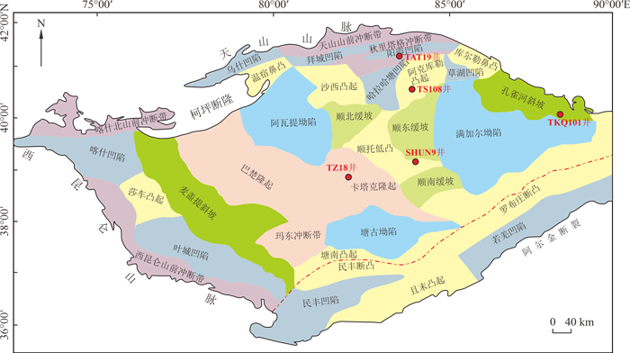
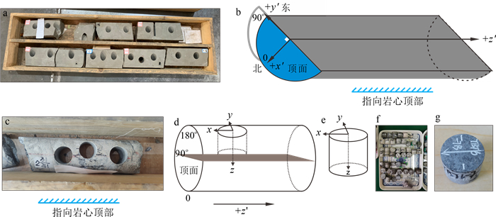
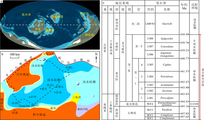
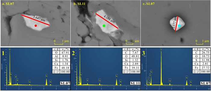
Methods

To this end, paleomagnetic analyses were carried out on 43 Silurian sandstone samples collected from five boreholes (TKQ101, SHUN9, TAT19, TZ18, and TS108)in the Tarim Basin. Meanwhile, rock magnetic measurements, scanning electron microscope (SEM) and energy dispersive spectral (EDS) observations were conducted on representative samples to identify the predominant magnetic carriers. Furthermore, the paleocurrent direction inferred from the corrected maximum magnetic susceptibility (Kmax)axis of the anisotropy of magnetic susceptibility (AMS) using remanent magnetization was analyzed.
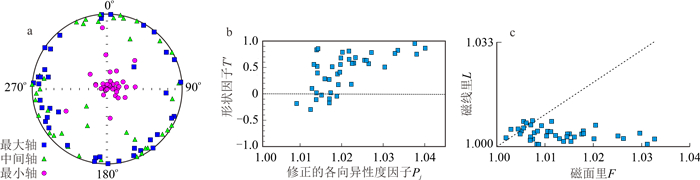
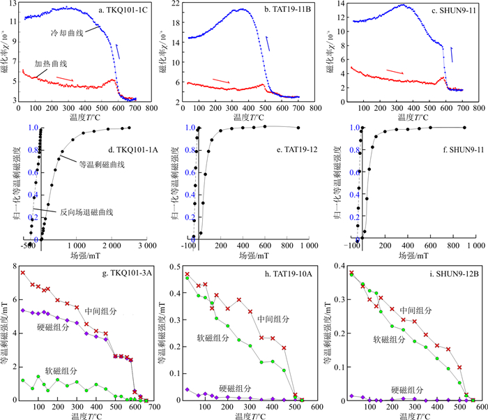
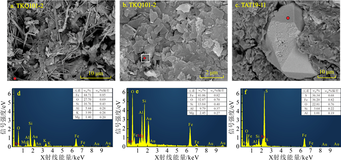
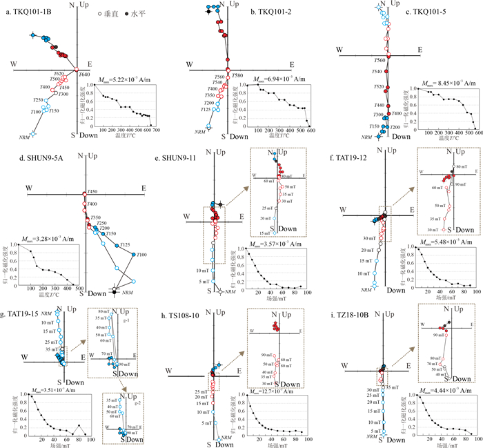
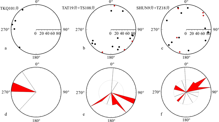
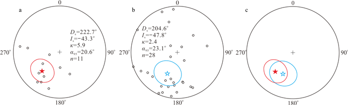
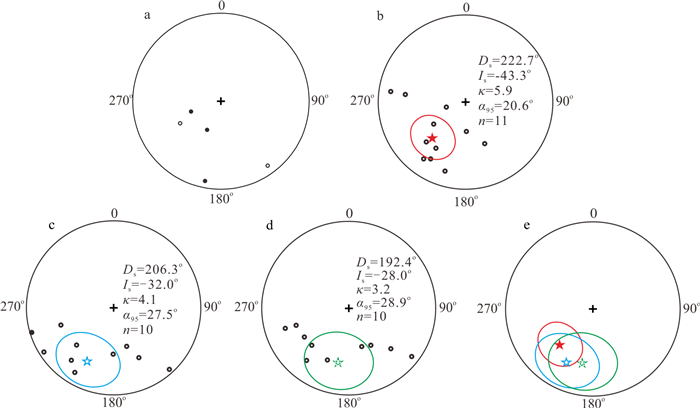
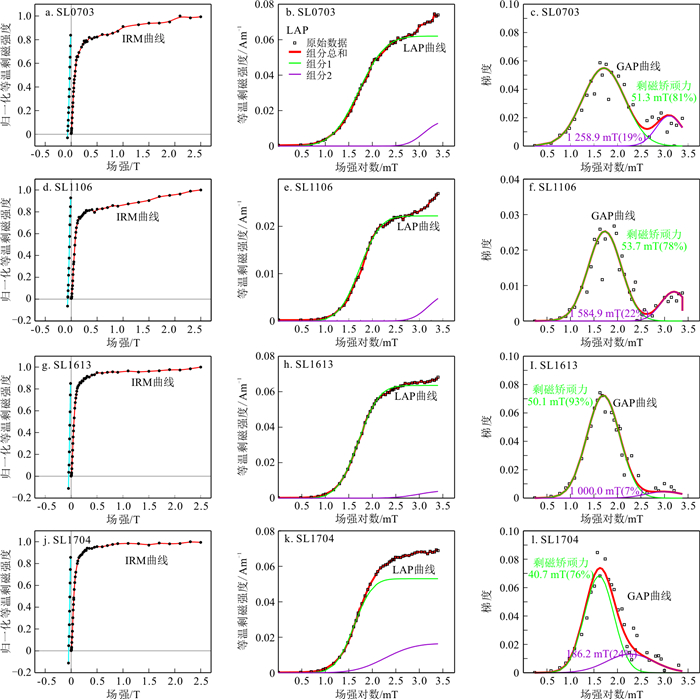
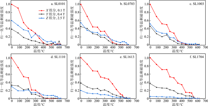
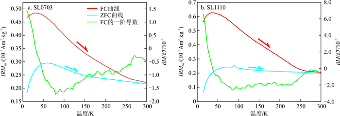
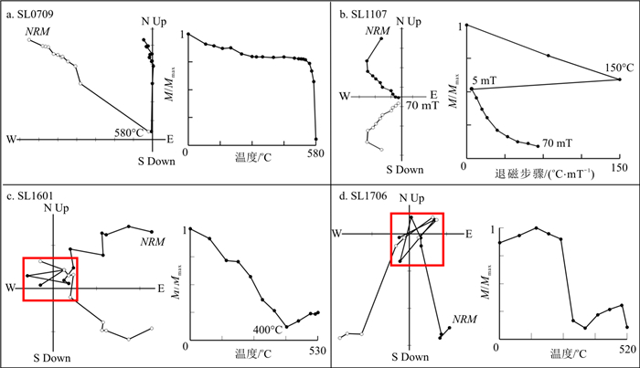
Results

AMS results indicate a sedimentary fabric preserved in the studied drilling cores, suggesting their stratigraphy are overall horizontal.Rock magnetic results, SEM and EDS observations reveal that magnetite is the dominant magnetic carrier for the TKQ101 samples, with small amounts of goethite and hematite, while pyrrhotite and magnetite are the dominant magnetic carriers for the other samples. The demagnetization results indicate that the viscous remanent magnetization (VRM) acquired in the present geomagnetic field and the characteristic remanent magnetization(ChRM) of the Silurian formation can be isolated for the TKQ101 samples, where the original azimuth rotations (R, R') estimated by VRM and ChRM are consistent. Furthermore, the paleocurrent direction inferred from the corrected Kmax is supported by the geological evidence, suggesting a counterclockwise rotation of 258.0°-262.0°of the TKQ101 drilling cores. Only one remanence component was isolated for the majority (~90%) of samples from the other four boreholes, which is a superposition component of the VRM acquired in present geomagnetic field and the chemical remagnetization caused by fluid activities, such as oil-gas migration and accumulation, during the Himalayan period. Therefore, it is more reliable to reorient these drill cores by using the VRM component, with confirmation of the paleocurrent direction inferred by the corrected Kmax and geological evidence.

Conclusion

In summary, to restore the original orientations of these drilling cores, the following rotation angles are required: 258.0°-262.0° counterclockwise rotation for the TKQ101 drill cores; 148.1°, 221.2°, and 318.2° counterclockwise rotation for the 4th, 5th and 6th sections from the borehole SHUN9, respectively; 269.8° and 155.9° counterclockwise rotation for the sections 3 and 5 from the borehole TAT19, respectively; 239.3° and 256.6° counterclockwise rotation for drill cores from the boreholes TS108 and TZ18, respectively.

Logging evaluation of shale laminae: A case study from the Wufeng-Longmaxi formations in the southern Sichuan Basin
Tan Yuhan, Zhang Fengsheng, Yao Yabin, Wu Heng, Nian Tao
2023, 42(6): 281-296. doi: 10.19509/j.cnki.dzkq.tb20220385
Abstract:
<p>Shale laminae influence shale reservoir quality and fracturing, whereas previous studies are simply based on geological materials. Taking full advantage of geophysical logging data could provide novel insights for shale laminae evaluation in drilled boreholes.</p></sec><sec><title>Methods

Cored boreholes in the Wufeng-Longmaxi formations in the southern Sichuan Basin are utilized in this study. Shale cores, CT scanning based on full-diameter cores, large-sized thin sections, X-ray diffraction, and TOC content are first integrated to clarify shale laminae fabrics. Elemental scanning, microresistivity electrical imaging, multipole array acoustic, conventional and nuclear magnetic resonance logging techniques are interpreted to characterize shale laminae by geological calibration, and the methodology of logging evaluation on shale laminae has been set out.

Results

It is concluded that the target formation has developed four types of bed, includingthe silicic bed (lamina poorly developed), silicic lamina, calcareous lamina, and argillaceous lamina. Elemental scanning is implemented to determine laminae minerals and TOC content. Electrical imaging and the anisotropy index derived from multipole array acoustic and conventional logs are used to evaluate lamina density or development degree. Besides, electrical imaging is able to reflect the lamina thickness. Nuclear magnetic resonance is performed to analyze the variation in lamina pore structure.

Conclusion

Although logging resolution and response complexity can significantly affect the accuracy of logging interpretation of shale laminae, logging techniques rooted in petrophysical properties are valuable supplements for the evaluation of shale laminae and lamina associations.

Paleomagnetism of the Upper Cretaceous Daijiaping Formation red beds in the Chaling Basin, Hunan Province, China
Jin Dengkui, Li Yongxiang
2023, 42(6): 297-309. doi: 10.19509/j.cnki.dzkq.tb20220161
Abstract:
Objective

Red beds are widely used in palaeomagnetic studies as they can carry stable natural remanence. Most previous studies on red beds have mainly focused on lacustrine-fluvial facies, with limited targeting the aeolian red beds. Consequently, the influence of aeolian deposition processes and sedimentary environments on remanence records remains poorly understood.

Methods

In this study, we conducted a palaeomagnetic investigation of the red beds from the Upper Cretaceous Daijiaping Formation in the Chaling Basin, Hunan Province, China, to compare the stability and reliability of remanence in aeolian and lacustrine-fluvial red beds.

Results

Rock magnetic results indicate that magnetite, maghemite and hematite are the dominant magnetic remanence carriers. Specimens were subjected to stepwise thermal demagnetization, and only 1/6 of the specimens yielded characteristic remanent magnetisations (ChRMs). Although the mean directions of ChRM in both aeolian(Ds=222.7°, Is=-43.3°, κ=5.9, α95=20.6°, n=11) and lacustrine-fluvial (Ds=204.6°, Is=-47.8°, κ=2.4, α95=23.1°, n=28) samples are statistically indistinguishable, the distribution of individual ChRM directions is scattered, as evidenced by the large α95 values. Thin section observation reveals that the aeolian samples are predominantly composed of fine grains, with some coarser grains and almost no interstitial fillings compared with the lacustrine-fluvial red beds. This makes them susceptible to physical disturbance and subsequent chemical alteration, which compromises the stability of their remanence records. Analysis of palaeomagnetic data of specimens from different positions of an aeolian foreset bed reveals that the reliability of remanence is significantly influenced by aeolian depositional processes in case the angle between the foreset bed and the bedding plane is larger than 20°. Statistical analysis of palaeomagnetic data previously published from the Cretaceous red beds in South China and these in this study suggests that the remanence records in the Cretaceous aeolian red beds in South China tend to be less stable and less reliable, compared with that of the coeval lacustrine-fluvial red beds. It is probably because of their loose structure and low hematite content, which hinders the acquisition of primary remanence and makes them susceptible to diagenetic alteration.

Conclusion

These findings provide valuable insights for studying the stability and reliability of remanence in aeolian red beds and their application in palaeomagnetic study.

Rock magnetic properties of the Upper Silurian Longmu Co Upper Formation in the North Qiangtang Terrane
Wang Baofeng, Chen Xin, Jiang Nan, Wei Bitian, Zhang Weijie, Wu Ke, Xu Pengxiang, Zhou Yanan, Liu Yuchun, Wu Hanning
2023, 42(6): 310-318. doi: 10.19509/j.cnki.dzkq.tb20220102
Abstract:
Objective

Palaeomagnetic study of the early Palaeozoic North Qiangtang Terrane can quantitatively constrain its palaeogeographic location since the Palaeozoic, which serves as an important foundation and key constraint for studying of the palaeotectonic pattern of the Qinghai-Tibet Plateau, the evolution of the Phanerozoic Tethys and palaeogeographic reconstruction.

Methods

Prior to palaeomagnetic study, it is essential to investigate the magnetic properties of rocks to identify the types and assemblages of magnetic carriers present in rocks, which will facilitate the selection of demagnetization experimental protocols and discussions on the primary nature of remanent magnetization. This paper focuses on the magnetic properties of limestone and sandstone from the Late Silurian Longmu Co Upper Formation in the North Qiangtang Terrane, through analyses of isothermal remanence acquisition curves, magnetic susceptibility with temperature(χ-T) curves, triaxial thermal demagnetization experiments, low-temperature magnetic properties tests, scanning electron microscopy (SEM) and energy dispersive spectral (EDS) analysis.

Results

Results show that magnetite is the predominant magnetic carrier in the limestone samples of the Longmu Co Upper Fm, with small amounts of pyrrhotite. The magnetic assemblage in the sandstone samples is more complex, dominated by magnetite, possibly with other magnetic minerals such as pyrrhotite.

Conclusion

Moreover, it demonstrates that stable high-temperature remanent magnetization components can be isolated from the limestone samples in the Longmu Co Upper Formation, making them suitable for further palaeomagnetic researches.