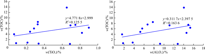
2023 Vol. 42, No. 5

Display Method:
Evaluation of slope stability of open pit based on factor space
Yi Fu, Meng Xingtao, Zhao Wenhua, Du Changbo
2023, 42(5): 1-9. doi: 10.19509/j.cnki.dzkq.tb20210773
Abstract:
Objective

The factors affecting the stability of an open pit slope are complex and fuzzy. Hence, it is difficult to evaluate the stability through mathematical and mechanical analysis methods.

Methods

According to the actual engineering characteristics and in-situ investigation of an open pit, four first-class evaluation indexes including landform, geological structure, rock mass properties and occurrence environment and 17 second-class evaluation indexes were determined. The stability evaluation model of open pit slope based on factor space is established. Firstly, the analytical hierarchy process(AHP) and entropy weight method are used to calculate the subjective and objective weights, and the combined weights of the factors affecting the stability of the open pit slope are given. Then, the unascertained measure theory is used to construct the measure function, calculate the single factor measurement matrix to evaluate the slope stability, reduce the dimension of the factor space through factor synthesis, and generate the combined factor measure vector. Finally, the stability of the open pit slope is evaluated through the confidence recognition criteria. Taking the typical slope profile of the eastern slope of Qidashan open pit iron mine as an example, the factor space evaluation results are compared with the calculation results of the limit equilibrium method and the finite difference method, and the reliability of the slope evaluation method is verified.

Results

The results show that the evaluation results of factor space model are basically consistent with the results obtained from the field investigation, and are consistent with the calculation results of limit equilibrium method and finite difference method, which verifies the accuracy and scientificity of the established factor space evaluation model. Based on the comprehensive analysis of the factor space evaluation results and the calculation results of other methods, four slope profile protection and treatment suggestions are given.

Conclusion

The factor evaluation model simplifies the process of slope stability evaluation, improves the accuracy of the evaluation results of the model, and can provide a reference for the stability evaluation of an open pit slope with similar geological conditions.

Drilling process simulation and dynamic characteristic analysis of soft-hard-staggered strata based on Abaqus
Wen Guojun, Zhang Fengdou, He Xin, Liu Haojie, Wang Yudan, Zhao Quan
2023, 42(5): 10-19. doi: 10.19509/j.cnki.dzkq.tb20220074
Abstract:
Objective

With the development of drilling technology for deep strata, the study of the dynamic characteristics and parametric response law of drill bits and deep complex strata during drilling has become a key and difficult point in research.

Methods

In this paper, a combination of numerical simulation and response surface analysis was used to study the dynamic characteristics of PDC bits and typical complex strata in the drilling process, and parametric analysis was carried out. In this paper, soft-hard-staggered strata with dip angles as a typical complex formation were studied, the dynamic damage finite element simulation model between the PDC drill bit and the soft-hard-staggered strata with the full real size was established based on Abaqus, and the dynamic characteristics of the drill bit subjected to the reaction force of the strata during drilling were derived. Numerical simulation experiments were also conducted by orthogonal tests to investigate the dynamic characteristics of the PDC bit under different formation parameters and drilling parameters.

Results

The single factor analysis and response surface analysis were used to model and identify the relationship between drilling parameters and stratigraphic parameters and the reaction force on the drill bit by the stratum and to obtain the changing trend and regression model of the reaction force on the drill bit by the stratum under multiple parameters. The results showed that the higher the inclination angle of soft-hard-staggered strata, the higher the average value and peak impact value of the bit subjected to the stratigraphic reaction force. The larger the ratio of softness to the hardness of the strata is, the larger the average and peak reaction forces on the drill bit. Within a certain range, increasing the rotational speed will reduce the impact of the reaction force on the drill bit.

Conclusion

The research results provide a basis for predicting the bit reaction force during drilling in deep and complex formations and guide the control of the drilling trajectory in deep and complex formations, which is of great significance for deep geological drilling.

Optimization of direct-hole cutting blasting technology for deep-buried layered surrounding rock diversion tunnels
Jiang Shouguo, Luo Shuaibing, Jiang Nan, Sun Jianbin, Zhou Haibo
2023, 42(5): 20-26. doi: 10.19509/j.cnki.dzkq.tb20220072
Abstract:
Objective

In recent years, the trend of tunnel blasting construction extending to depth is becoming more and more significant, and the influence of layered rock mass in deep buried diversion tunnel on cutting quality in blasting construction is the key to blasting construction.

Methods

In order to study the influence of the location of blasting in deep layered surrounding rock on the cut blasting, a three-dimensional finite element numerical calculation model was established by using ANSYS/LS-DYNA, based on the blasting excavation project of the diversion tunnel of San Gabán hydropower station in Peru. The damage area caused by cut blasting was analyzed, and the optimization scheme was put forward for field test.

Results

The results show that the boundary area of layered surrounding rock has a certain influence on the range of rock damage caused by cutting blasting. The closer to the boundary area of layered surrounding rock, the smaller the range of rock damage. In order to increase the damage area of cut blasting, the location of blasting should keep a certain distance from the boundary area of layered surrounding rock.

Conclusion

The optimized blasting scheme was tested on site and good blasting effect was achieved. In this study, numerical simulation was used to optimize the position of the cutting hole accroding to the law of rock damage evolution, which can improve the economy and safety of tunnel construction.

Influence of frozen soil on the seismic responses of bridge structures considering the effect of temperature
Yin Pengcheng, Sun Yixian, Pang Yutao, Wang Xiaowei, Zhu Weiyuan
2023, 42(5): 27-35. doi: 10.19509/j.cnki.dzkq.tb20220505
Abstract:
Objective

Recently, the seismic damage of an actual bridge structure in a frozen soil area has shown that the presence of frozen soil will increase the lateral stiffness of the bridge foundation, which may cause more serious seismic damage to the bridge structure, but there is a lack of research on the frozen soil-pile interaction effect of frozen soil bridge structures under seismic loadings and the corresponding seismic responses.

Methods

The present paper proposed efficient nonlinear numerical models to consider the effect of the frozen soil-pile interaction on the seismic responses of structures. First, the relationship between the depth of frozen soil and surface temperature was constructed. Then, the p-y spring modelling approach was presented to simulate the seismic behavior of frozen soil. Several as-recorded ground motions were selected as the seismic input. The seismic responses of piers and bearings of regular bridges with different depths of frozen soil under seismic loadings were investigated.

Results

The results show that the proposed efficient nonlinear numerical model can be adopted to model the seismic behavior of bridges considering frozen soil. And the proposed p-y curves for frozen soil can accurately predict the p-y relationship from the existing tests. When the PGA is relatively small, the pier curvature increases slightly; by contrast, in the case of large PGA, frozen soil can significantly increase the curvature demands, which can make the pier enter into the inelastic behavior. When the depth of frozen soil is small (the temperature is -5℃), the bearing displacement increases significantly, which increases the probability of unseating under seismic loadings. Moreover, frozen soil can transfer to the adverse locations of structural systems under seismic loadings.

Conclusion

Therefore, the conclusions of this paper can provide the necessary theoretical basis and data support for studying the seismic performance and corresponding seismic design methods of frozen soil bridge structures in China, which is of great significance for promoting the development and engineering application of disaster prevention and mitigation of bridge engineering in frozen soil areas in China.

Degradation law and mechanism of the compressive strength of mica quartz schist under dry-wet cycles
Li Zhigang, Ye Honglin, Liu Wei, Xu Guangli, Ma Yun, Zhu Jia
2023, 42(5): 36-42. doi: 10.19509/j.cnki.dzkq.tb20210817
Abstract:
Objective

The dry-wet cycles can promote the deterioration of the mechanical properties and stability of schist slope rock masses and induce geological disasters such as landslides and collapses.

Methods

Taking mica quartz schist, which is widely distributed in Shiyan, Hubei Province, as the research object, uniaxial compression tests and electron microscope scanning were carried out on mica quartz schist samples under different dry-wet cycles to reveal the degradation law and mechanism of its compressive property.

Results

The results show that under the action of dry-wet cycles, the degradation effect of the compressive strength and elastic modulus of mica quartz schist were obvious. The degradation rate was fast and the degradation range was large in the early stage, but the degradation rate was slow and the degradation range was low in the later stage. The macroscopic failure modes were gradually controlled by the schistosity planes, which gradually evolved from styles of "X" and "Y" failure to along the schistosity planes failure. The microstructure was characterized by continuous spalling and granulation of flake mineral particles, and the microcracks as well as pores were gradually developed, expanded and connected. The mica quartz schist produces secondary minerals, ions and rock cuttings and leaves the rock continuously under dry-wet cycles, which promotes the preferential expansion and cracking of schistosity, microcracks and other structural planes. which then degrades the overall mechanical properties of the mica quartz schist.

Conclusion

The research results can provide a theoretical basis for the stability analysis and treatment design of schist slopes.

Geomechanical evolution model of bedding rock landslides in construction areas: A case study of the Maidiping landslide in Tiefeng Town, Wanzhou
Wang Yu, Feng Xiao, Du Juan, Liu Yang, Li Dong, Chai Bo
2023, 42(5): 43-51. doi: 10.19509/j.cnki.dzkq.tb20210774
Abstract:
Objective

Engineering construction is the main cause and risk-bearing object for landslides, where excavation at the foot of a slope has a great impact on the stability of a slope. In the cascading slope areas, the progressive damage of soft inclusions such as mudstone shale under the combined effect of natural conditions and engineering activities has led to the occurrence of landslides on a large scale, which cause irreparable economic losses. Therefore, the destruction process of landslides needs to be analysed and discussed.

Methods

A geomechanical model of the landslide evolution process under the action of rainfall and engineering activities was established based on the investigation of a typical bedding rock landslide in Tiefeng Town, Wanzhou. The mechanical parameters of the soft muddied layer were obtained by ring shear experiments. FLAC3D was applied to simulate the shear deformation of the landslide under the conditions of manual excavation and rainfall, which was combined with the rigid body limit equilibrium method to analyse the trend of landslide stability and compare with the field survey results.

Results

The results show that the weak interlayer goes through two stages of natural slow softening and artificial excavation rapid softening and belongs to the strain softening model. The strength decreases continuously with the increasing shear displacement, and the strength decreases rapidly when a critical displacement is reached. The large deformation of Maidiping landslide occurs during the rainfall period after the excavation of the foot of the slope, which is consistent with the experimental results.

Conclusion

The experimental and simulated results agree with the results of field investigation, which verify the present geomechanical model of the cis-layered rock landslide. The results are of guidance for construction activities and disaster prevention and mitigation of cis-slopes.

Supporting effect analysis of the Huangnibian landslide based on MatDEM
Wang Fei, Xu Chu, Li Wei
2023, 42(5): 52-60. doi: 10.19509/j.cnki.dzkq.tb20220015
Abstract:
Objective

The Huangnibian landslide is a small- to medium-sized cohesive soil landslide that has shown signs of movement. It is urgent to implement support and remediation measures for this landslide. This study aims at analysing the failure mechanism of the landslide, verifying the stability requirements of existing support structures, and exploring reasonable and effective support locations and forms.

Methods

This paper establishes a three-dimensional model of the Huangnibian landslide under the condition of a once-in-20-year flood level based on MatDEM. The deformation of the landslide under three conditions of no support, retaining wall support, and the combination of retaining wall and anti-slide pile support were simulated, and then the supporting effect of different supporting schemes according to the displacement field was analysed.

Results

The simulation results show that: ① The landslide is unstable under the once-in-20-year flood level; ② The sliding body is cut from the slope foot of Binhe Road in the case of no support and from the slope foot of the Expressway in the case of retaining wall support, indicating that the existing retaining wall support structure does not meet the stability requirements of the landslide, and therefore the slope foot of the Expressway needs to be mainly supported; and ③ The scheme that arranges the anti-slide piles at the slope foot of the Expressway and adds a retaining plate between the anti-slide piles is effective to support the landslide and prevent soil between piles from slipping.

Conclusion

The analysis results can provide references for subsequent engineering design and construction and verify the applicability of MatDEM in landslide analysis.

Influence of dredging on the foundation deformation of antique stone bridge built on soft ground and its mechanistic analysis
Li Yipeng, Ma Shuzhi, Jia Hongbiao, Li Xuan
2023, 42(5): 61-69. doi: 10.19509/j.cnki.dzkq.2022.0168
Abstract:
Objective

The great demand for urban landscape improvement and reconstruction has required increasing dredging practices for waterfront buildings, particularly antique buildings. To effectively protect such antique buildings, the influence of dredging on the ground deformation of antique buildings needs to be carefully considered in the dredging operations.

Methods

To obtain a better understanding of the effect of dredging activities on antique buildings, the influence of dredging depth, dredging slope shoulder width and dredging slope ratio on the displacement and stress distribution of an antique stone bridge on soft ground via a three-dimensional model of the bridge body and its ground strata was studied in this paper. Based on the calculated results, mechanistic explanations of dredging on the ground deformation of antique stone bridges were proposed.

Results

The simulated results show the following: ① Dredging effects on the antique stone bridge mainly appeared as giving rise to the displacement of the bridge and the near strata, changing the stress distribution, and forming a plastic zone in the adjacent area of strata. As a result, dredging activities render a more complex stress and displacement distribution to the bridge and the strata around the bridge. ② Different dredging parameters have different effects on the displacement fields and stress fields of the bridge and its surrounding area. The dredging depth primarily affects the displacement magnitude of the soil, and the dredging slope shoulder width is the crucial factor affecting the scope of the dredging effect, whereas the dredging slope ratio and the dredging slope shoulder width jointly manipulate the change in the soil displacement curve and the development of the plastic zone. ③ In dredging projects, the setting of dredging parameters should not only meet the requirements of engineering practicability and economy but also reasonably determine the dredging parameters and control the impact of dredging on adjacent ancient buildings and take into account the width of the dredging slope shoulder width and the dredging slope ratio when determining the designed dredging depth.

Conclusion

The results in this work are of practical significance for dredging activity in antique building protection.

Characteristics and controlling factors of the organic-rich shale in the Wujiaping Formation of the Hongxing area, eastern Sichuan Basin
Wang Bijin, Bao Hanyong, Liu Haotian, Zhang Li, Zhao Shuai
2023, 42(5): 70-81. doi: 10.19509/j.cnki.dzkq.tb20230149
Abstract:
Objective

The organic-rich shale of the Upper Permian Wujiaping Formation in the Hongxing area of eastern Sichuan is an important replacement area for shale gas exploration in the Sichuan Basin, and the exploration breakthroughs have been made. But how to achieve large-scale storage increase and efficient development needs to be tackled.

Methods

This paper investigates the source and reservoir quality characteristics of the shale of the Wujiaping Formation in the Hongxing area of eastern Sichuan based on lithological, geochemical and gas-bearing test and analysis data and discusses the factors controlling the development of high-quality reservoirs.

Results

The results show that the shale of the Wujiaping Formation has a good organic matter type, dominated by type Ⅱ1 kerogen, with high TOC content, high carbonate content and high gas content. The shale TOC content generally ranges from 1% to 11%, with an average value of 6.89%; the lithology is mainly siliceous shale and mixed shale, followed by calcareous shale, and the overall brittle mineral content is high; the reservoir organic matter pores are developed and have good physical properties, and the porosity generally ranges from 2% to 5%, with an average value of 3.1%. Comprehensive analysis shows that the high-quality reservoir of the Wujiaping Formation is strictly controlled by the depositional environment. The reservoir pore type is dominated by organic pores.

Conclusion

Under the control of this depositional model, sea level rise and fall, volcanic activity and palaeoclimate have jointly controlled the inhomogeneity and high-quality shale reservior distribution.

Fine-grained sublacustrine fan deposits and their significance in shale oil reservoirs in the Lucaogou Formation in the Jimsar Sag, Junggar Basin
Kang Jilun, Wang Jiahao, Ma Qiang, Li Chunquan, Chen Xingxing
2023, 42(5): 82-93. doi: 10.19509/j.cnki.dzkq.2022.0074
Abstract:
Objective

The Jimsar Sag of the Junggar Basin is representative of successful shale oil exploration in China. However, the sedimentary facies in the Permian Lucaogou Formation hosting shale oil has long been disputed. Previous studies proposed two contradictory environments of shallow lakes and semideep to deep lakes in the interior lacustrine basin and identified sandstone interlays as deltaic distal sandbar deposition and beach and bar deposition.

Methods

The study combined core observations with analyses of sandstone granularity, logging facies, and reservoir properties to identify the development of sublacustrine fans in a semi-deep to deep lake background.

Results

Fine-grained turbidity currents played a significant role in the transportation and deposition of sediment in these fans. The lithofacies observed included lenticular-wave bedded muddy siltstone to siltstone (dominant type), parallel bedded siltstone, graded siltstone, and massive-graded bedded siltstone to fine-grained sandstone. The cumulative probability granularity curves exhibited smooth upper arches with a high suspension population, and the cross-spots on the C-M diagram were located in the grade suspension zone. The sublacustrine fans consisted of sedimentary microfacies of sheet-like lobes and gravity flow channel levees, showing fining- and coarsening-upwards successions, respectively. These fans contained numerous interlayers of siltstone and fine-grained sandstone, as well as terrigenous detrital particles that influenced the mineral content and enhanced shale oil reservoir properties by promoting the growth of solution pores.

Conclusion

The study concluded that sublacustrine fan deposits are thin-bedded and fine-grained, and they occur frequently. It also determined that desert reservoirs formed in the areas where sublacustrine fans were deposited, which has significant implications for shale oil exploration in the study area.

Pore structure and movable fluid characteristics of tight sandstone reservoirs in the Lower Shihezi Formation in the Hangjinqi area, Ordos Basin
He Yun, Wang Ruifei, Zhang Zhanyang, Wang Ruyue, Yin Shuai, He Weiling, Chen Ruina, Xiao Xue
2023, 42(5): 94-102. doi: 10.19509/j.cnki.dzkq.2022.0134
Abstract:
Objective

In recent years, new discoveries have been made in the He 1 Member of the Hangjinqi Gas Field. And the initial gas production of some wells by fracturing can reach 10×104 m3/d, which shows that the He 1 Member has great exploration potential. However, due to the strong heterogeneity of the He 1 Member, the gas production mechanism of the He 1 Member is not clear at present, which restricts its efficient development. To accurately and quantitatively characterize the microscopic pore structure and movable fluid characteristics of tight gas sandstone reservoirs.

Methods

In this paper, taking the tight sandstone reservoir in the He 1 Member of the Shangshihezi Formation in the Hangjinqi Gas Field as an example, NMR and CT tests were used to study the response characteristics and fluid identification ability of different types of pores in tight sandstone.

Results

The research shows that the porosity of the test samples is mainly distributed in 1.7%-10%, and the gas permeability is mainly distributed in 0.1×10⁻³-1.4×10⁻³ μm2, which belongs to the typical low-porosity and low-permeability porous tight sandstone reservoir. According to the T2 relaxation time curve of the saturation component before centrifugation, the pore type of the reservoir in the He 1 Member is bimodal (mainly the left peak, the right peak is not obvious), including 3 subtypes: micropore-small pore type, small pore-mesopore type, micropore-small pore-mesopore type. The T2 relaxation time intervals corresponding to the above three subtypes of pore types are 0.1-10 ms, 1-100 ms, and 0.1-100 ms, respectively. The results of 3D CT scans show that the micropore-mesopore reservoir has the best physical properties, followed by the micropore-small pore-mesopore type, and the micropore-small pore type reservoirs have relatively poor physical properties. The T2 cut-off values of the tested samples were mainly distributed between 1 and 14 ms, with an average value of 6.11 ms. There is a certain negative correlation between the T2 cut-off value and the movable fluid percentage of the rock samples. The movable fluid porosity and permeability have a very good positive correlation, reflecting that the amount of movable fluid is significantly affected by the reservoir permeability and the number of throats. The movable water saturation in the tight sandstone reservoirs of He 1 Member in the study area is mainly distributed at 4%-9%, with an average value of 5.8%.

Conclusion

Overall, the original movable water saturation of the He 1 Member is low and has great development potential.

Depositional characteristics of a relay ramp controlled braided deltaic system: A case study in the Eocene Huizhou Sag, Pearl River Mouth Basin, China
Tao Wenfang, Ge Jiawang, Lei Yongchang, Li Xubiao, Zhu Xiaomin
2023, 42(5): 103-114. doi: 10.19509/j.cnki.dzkq.tb20220202
Abstract:
Objective

Tectonic transfer zones (or named as relay ramps) can have a profound impact on the drainages catchment, sediment dispersal and reservoirs distribution patterns; they are also important for hydrocarbon transport and accumulation processes. It is a hot object of current research interest to sedimentary geologists as well as petroleum geologists. A few different types of tectonic transfer zones are observed in the Eocene Huizhou Sag, the Pearl River Mouth Basin, South China Sea. The HZ25 area linking the Huizhou 26 and Xijiang 30 Sags is a typical overlapping transfer zone that controls the development of a large set of braided-deltaic system.

Methods

Based on newly acquired and processed high-quality 3D seismic data, three drilling logs, cores, and thin slices are utilized to discuss the characteristics of the relay ramp-controlled braided deltaic deposits and reservoirs in this paper.

Results

The results show that the Late Eocene climate was relatively hot and humid, and thus, abundant terrestrial clastic are collected and transported from the Dongsha Uplift source area via the HZ25 relay ramp routing system. Subsequently, a set of thick-bedded braided-delta deposits was deposited in the HZ26 Sag. The braided deltaic sandstones are generally coarse-grained with relatively poor sorting and roundness. It is dominated by mainly lithic sandstone. The particle size probability curve and C-M diagram display typical multiple traction flow characteristics. Large-scale cross bedding, high-angle inclined bedding and extensive scour surfaces in multistory fining-upwards cycles are common in core observations. It is implied that rich and hydrodynamic traction flow regimes are developed. The drainage dispersal pathways are redirected by the internal tectonic belts within the relay ramp, which are characterized by a large-scale but low-gradient (less than 3 degrees) physiographic slope. Strong hydrodynamic forces associated with facilitated deltaic drainage resulted in a high sand ratio of approximately 52% on average. The maximum advancement of the braided deltaic system is approximately 8 km, and its lobe-like geometry is strictly reorganized by the special tectonic-geomorphic pattern of the relay ramp zone.

Conclusion

The frontal deposits of the braided deltaic system have relatively good sandstone sorting, and thus, the relevant deposits are characterized by a higher porosity than those observed in the braided-delta plain. The good stratigraphic-lithological traps controlled by the relay ramp coupled with the multiple stages of thick-bedded braided-deltaic deposits are most important in this study area, which could be selected as an exploration potential area in the future. Additionally, the braided deltaic deposits in the study area are mainly dominated by low-porosity and low-permeability reservoirs. The reservoir in the frontal area of the braided deltaic deposits could be a priority exploration and evaluation target for petroleum resources due to its low mud content and miscellaneous bases, moderate sorting and good pore connectivity.

Enrichment mechanism of organic matter in black rock series of the Niutitang Formation in Bahuang, Tongren, Guizhou
Bai Yang, Xie Hong, Wang Mengzhai, Lu Zhenghao
2023, 42(5): 115-127. doi: 10.19509/j.cnki.dzkq.2022.0128
Abstract:
Objective

A set of black rock series rich in organic matter developed in the Yangtze Plate of China in the Early Cambrian.

Methods

To explore the main controlling factors affecting the enrichment of organic matter, the samples of the Niutitang Formation in Bahuang, Tongren Guizhou Province were tested for total organic carbon (TOC), major, trace and rare earth elements.

Results

The results show that the organic carbon content of the black rock series show a trend of high→low→high from bottom→lower middle→upper. The redox indexes Ni/Co, V/Cr, V/(V+Ni) and U/Th and the index Mo/TOC for determining the retention degree of water in the basin indicate that the carbonaceous shale and polymetallic element shale rich in organic matter at the bottom and upper part of the Niutitang Formation are formed in oxygen-poor to anoxic, medium to strong limited retention environments. The lower middle phosphate rock layer is formed in oxygen-poor to oxygen-rich, medium retention sedimentary environment. The δCe shows that the study area experienced a process of transgression regression in the Early Cambrian. Babio reveals the high paleoproductivity at the bottom and upper part of the Niutitang Formation and the medium to high paleoproductivity at the lower-middle part. The Ti/Al indicates weak terrigenous input as a whole. Rare earth distribution mode, δEu anomaly and La/Yb-REE diagram show that the phosphorus ore bed and metal-rich shale are affected by hydrothermal activity, which brings rich nutrients and reducing sedimentary environment for the enrichment of organic matter in metal rich shale. The phosphorus ore bed was formed in the period of sea level rise, and the upwelling of ocean currents led to the oxygenation of the sedimentary environment, which was not conducive to the preservation of organic matter. Therefore, the content of organic matter in the lower middle phosphorus-bearing formation is low.

Conclusion

The key factor restricting the enrichment of organic matter in the black rock series of the Niutitang Formation is the generally reducing and retained sedimentary environment, and the medium-high paleoproductivity is an important basis for the enrichment of organic matter. Hydrothermal activity creates favorable conditions for the enrichment of organic matter in local strata (polymetallic enrichment layer), and terrigenous clastic input has little impact on the enrichment of organic matter. The rise in sea level is an unfavorable factor for the enrichment of organic matter. It is the "comprehensive model" under the joint action of multiple factors that control the enrichment of organic matter in the black rock series of the Niutitang Formation.

Research status of rock sliding specular reflection and its application in shale gas preservation
Wang Yufan, Xu Shang, Wen Yaru, Gou Qiyang, Zhang Zhiyao, Wang Zhengkai
2023, 42(5): 128-137. doi: 10.19509/j.cnki.dzkq.2022.0236
Abstract:
Objective

Specular reflection is a smooth surface formed during the sliding process of rock strata, with a certain metallic and glass luster and reflective properties. In some fault zones, these smooth surfaces are also known as fault mirrors (FMs). Specular reflection can be seen in many rock types, such as mudstone, shale, coal seam, carbonate rock, silicate rock and so on. The mechanism of specular reflection is different in different lithologies, but the formation of specular reflection is related to strata sliding. Therefore, the stress, slip rate, slip distance and temperature related to rock strata sliding have important influence on the formation of specularity.

Methods

A large amount of specular reflection is developed in the syncline Longmaxi Formation shale in Anchang, northern Guizhou. To find out the factors influencing the formation of specular reflection and the internal relationship between them and the gas content of shale in this paper, the development characteristics and formation mechanism of specular reflection and its effects on fluid flow and shale gas preservation conditions were summarized systematically through a large number of literature reviews.

Results

The results show that: (1) Stress, slip rate, slip displacement and temperature have important influence on the formation of specular reflection. (2) The formation of specular reflection depends on the combination form of stress and sliding rate. It is easier to form specular reflection under high-speed and high-stress conditions. Under low-speed and low-stress conditions, the specular reflection will not be formed even if the sliding displacement is large. (3) Under the same stress and sliding rate, the overall sliding displacement will promote the increase of specular coverage, and the specular coverage can even reach 100%. (4) The temperature makes the rock particles change from brittle to plastic, which can prevent the brittle fracture of the rock particles to a certain extent, and then sinter the rock particles, prompting the formation of specular reflection. (5) The specular roughness is very low, usually in the micrometer level, the average roughness range is only a few micrometers. (6) Specular cracks and slip distances are formed, which significantly improve the flow of shale gas, accelerated loss of shale gas may lead to poor gas.

Conclusion

Therefore, in the absence of roof and floor conditions, specular refection may be one of the important reasons for the poor gas content of shale.

Occurrence characteristics and main control mechanism of trace elements in Early Permian coal in the southern margin of North China Plate
Yuan Duoen, Bian Jiahui, Liu Zixuan, Zhang Liwei, Pan Sidong
2023, 42(5): 138-149. doi: 10.19509/j.cnki.dzkq.2022.0104
Abstract:
Objective

The study focuses on the development of critical elements in coal as a new area of mineral resource exploration.

Methods

Various analytical methods including X-ray diffraction, X-ray fluorescence spectrum, and inductively coupled plasma-mass spectrometry were used to investigate the mineralogy and geochemical characteristics of Early Permian middling coal in the southern margin of the North China Plate.

Results

The results indicate that the Early Permian coal in this region is mainly composed of minerals such as kaolinite, illite, tobelite, chlorite, and calcite, with SiO2, Al2O3, and CaO as the main elements. The coal seam samples also show enrichment of Li, with an average content of 76.83×10⁻⁶, as well as slight enrichment of Zr and Th. Other elements, such as Co, Zn, Rb, Cd, and Cs, are significantly depleted compared to the world average for hard coal.

Conclusion

Through correlation analysis and geochemical interpretation, it was concluded that the Li element in the Early Permian coal is mainly associated with clay minerals like kaolinite and is controlled by terrigenous debris. The uplift, weathering, and denudation of Mesoproterozoic K-feldspar granite and Carboniferous Benxi Formation palaeoweathering crust bauxite in the northern Yinshan ancient land, influenced by Variscan tectonic movement, became the primary source area for the Early Permian coal in the southern margin of the North China Plate. The salty and anoxic reducing sedimentary environment of the peat water medium favors the adsorption and deposition of Li by clay minerals, particularly kaolinite.

Mineralogy and geochemistry of pyrochlore from the Shaxiongdong Nb-REE deposit, northwestern Hubei Province: Implications for the niobium enrichment mechanism in carbonatites
Qin Zhijun, Zhou Bao, Chang Sengren, Su Jianhui, Shao Hui
2023, 42(5): 150-160. doi: 10.19509/j.cnki.dzkq.2022.0197
Abstract:
Objective

The Shaxiongdong carbonatite-alkaline related Nb-REE deposit is located in the Wudang area of the south Qinling Belt, but the studies on Nb mineralization in this deposit are scarce.

Methods

Detailed petrographic observations were made by using polarizing microscope, optical cathodoluminescence and backscattered electron testing. The structure, composition and symbiotic relationship of the minerals were identified. The composition of two types of pyrochlore was analyzed by electron probe and the mechanism of niobium enrichment was discussed.

Results

The Shaxiongdong complex consists of three types of rocks that are spatially closely related: Meta-pyroxenite, syenite and carbonatite, of which the carbonatites are the major hosts of Nb mineralization characterized by main pyrochlore. This implies that Nb was concentrated to economic values in the carbonatite stage after extensive fractionation of the parental carbonated silicate magma. The pyrochlore in the deposit can be classified into two types on the basis of micro-textures: ① The primary ones (Pcl1) are euhedral to subhedral and display oscillatory zoning, implying their direct crystallization from carbonatite melts; ② The altered grains (Pcl2) exhibit patchy zonation under BSE images due to hydrothermal alteration. EPMA analytical results indicate that both types are rich in Nb and F at the B and Y sites, respectively, and at the A site, they are similarly mostly rich in Ca, thus named F-Ca-pyrochlore, with minor Na, thus named F-Na-pyrochlore.

Conclusion

The good positive correlations between F and Nb in both types of pyrochlore indicate that F plays a key role in the enrichment of niobium during magma differentiation. On the other hand, compared to the primary pyrochlore, the altered ones have relatively low Nb2O5, CaO, Na2O and F but high UO2, Ta2O5, SrO and SiO2, indicating that the fluids responsible for pyrochlore alteration are rich in Sr, Si and U, and the alteration tends to mobilize Nb in early pyrochlore, a process that is able to lower the Nb budgets of the deposit.

Major and trace elemental compositions and geological significance of sphalerite in the Fuxingtun Ag-Pb-Zn polymetallic deposit, Horqin Right Wing Front, Inner Mongolia
Zhang Qing, Zhang Cheng, Duan Hailong, Xu Hongguo, Zhang Xin
2023, 42(5): 161-174. doi: 10.19509/j.cnki.dzkq.tb20230172
Abstract:
Objective

The Fuxingtun deposit is a recently discovered large Ag-Pb-Zn polymetallic deposit in Horqin Right Wing Front area, Inner Mongolia. However, the researches on the deposit are very scarce. The study investigates occurrence characteristics of ore-forming elements, precipitation mechanism and genetic type of the deposit, in order to provide theoretical basis for the genesis of the deposit.

Methods

This study focused on sphalerite in different stages of the Fuxingtun Ag-Pb-Zn polymetallic deposit, and obtained metallography, major and trace elemental compositions of sphalerite, in order to discuss the precipitation mechanism of ore-forming elements and the genetic types of this deposit.

Results

Combined with field investigation and metallography observations, the metallogenic process of the Fuxingtun deposit can be divided into three stages: Cu-Zn sulfide stage (Stage Ⅰ), Pb-Zn sulfide stage (Stage Ⅱ) and Pb-Zn sulfide stage (Stage Ⅲ). The results of electron probe microanalysis show that the content of Fe in sphalerite varies greatly, and there is an obvious negative correlation between Fe and Zn. The results of LA-ICP-MS analysis showed that, the contents of Fe, Mn and In in sphalerite decreased gradually from Stage Ⅰ to Ⅲ, whereas those of Ga, Ge and Sb increased slightly. Based on the diagrams of laser ablation signal curve and the correlation among different elements, this study constrained that Fe, Mn, Cd, Cu In, and Ag in sphalerite are present as the form of isomorphism. On the other hand, Pb exists in the form of micro-inclusions, while Bi and Sb mainly occur as galena micro-inclusions in sphalerite. The trace element compositions of sphalerite grains also show that the periodic pressure fluctuation in the ore-forming process is responsible for the formation of oscillatory zone in sphalerite. We proposed that the multiple decompression and cooling of ore-forming fluids are the main mechanism of mineral precipitation in the Fuxingtun deposit.

Conclusion

Combined with the geological characteristics of the deposit and the trace element characteristics of sphalerite, it is proposed that the Fuxingtun Ag-Pb-Zn polymetallic deposit is a medium-sized, epithermal sulfide deposit.

Provenance and tectonic setting of the Upper Cretaceous Yaojia Formation sandstones in the Hailijin area, southern Songliao Basin: Constraints from petrogeochemistry and zircon U-Pb chronology
Zang Yahui, Li Jimu, Ning Jun, Wang Haitao
2023, 42(5): 175-190. doi: 10.19509/j.cnki.dzkq.2022.0153
Abstract:
Objective

Tracing the provenance of host clastic rocks is key for understanding uranium reservoir projection and uranium source evaluation of alluvial uranium ore.

Methods

The Hailijin uranium ore, of which the host rock is the Upper Cretaceous Yaojia Formation, is located in the southern part of Songliao Basin, northeastern China. This paper performed detailed petrography, whole-rock geochemistry and detrital zircon U-Pb geochronology of sandstone in the Yaojia Formation.

Results

Twenty-six samples collected from 16 drill holes display high contents of SiO2 and relatively low contents of Al2O3, Fe2O3, MgO, MnO, Na2O and TiO2, which plot in the area of lithic sandstone to sublithic sandstone, thus indicative of source rocks as the felsic components. The chemical index of alteration values range from 62.93 to 83.46, while the index of compositional variability values range from 0.4 to 1, which corresponds to moderate chemical weathering in a semiarid to semihumid climatic setting. The geochemical discriminant diagram shows that the tectonic background of the Yaojia Formation is a passive continental margin. Zircon U-Pb ages are mainly distributed at 180-110 Ma, 320-230 Ma and 2 536-1 738 Ma.

Conclusion

Combined with stratigraphy, magmatic records around the Songliao Basin and regional tectonic evolution, this study suggests that the sediments of the Yaojia Formation in the Hailijin were sourced from the Linxi area of the southern Great Xing'an Range.

Characteristics and controlling factors of the present geothermal field in the Songliao Basin
Zhang Qiaoran, Xiao Hongping, Rao Song, Shi Yizuo, Li Wenjing, Huang Shunde, Hu Guangming
2023, 42(5): 191-204. doi: 10.19509/j.cnki.dzkq.tb20230058
Abstract:
Objective

The geothermal field in the present sedimentary basin is a result of the energy balance between various dynamic processes on the Earth. It serves as an important tool for understanding continental dynamics, such as tectonic deformation and the evolution of the continental lithosphere. Additionally, it provides the basis for evaluating regional geothermal resources.

Methods

A comprehensive study of the geothermal field in the entire Songliao Basin was conducted using oil-test temperatures from 826 wells and thermal conductivities measured by the optical scanning method. Formation temperatures at depths of 1 000 m, 2 000 m, 3 000 m, and 4 000 m were estimated using deep temperature prediction technology.

Results

The results indicate that the present geothermal gradient in the Songliao Basin ranges from 22.5 to 69.0℃/km, with an average of 44.0℃/km. The thermal conductivity values of rocks in the central depression area are relatively concentrated, mostly ranging from 1.60 W/(m·K) to 2.40 W/(m·K), with an average of 1.84 W/(m·K). Among these, mudstone has the lowest thermal conductivity, with an average of 1.77 W/(m·K); siltstone has a middle range with an average of 1.87 W/(m·K); and fine sandstone has the highest thermal conductivity, with an average of 2.12 W/(m·K). The heat flow ranges from 35.0 to 98.8 mW/m2, with an average of 76.9 mW/m2. The basin exhibits a typical "hot basin" characteristic, with higher heat flow in the central depression and lower heat flow in the slope and uplift areas, forming an annular distribution pattern. Geothermal anomaly areas are distributed in the northeast of the central depression and the northwest of the southeastern uplifted region. The formation temperature at a depth of 1, 000 m ranges from 26.9 to 72.3℃, with an average of 47.9℃; at 2 000 m, it ranges from 49.4 to 141.3℃, with an average of 91.9℃; at 3 000 m, it ranges from 71.8 to 167.5℃, with an average of 135.8℃; and at 4 000 m, it ranges from 94.3 to 210.9℃, with an average of 179.8℃.

Conclusion

These findings suggest that the subduction of the Pacific Plate beneath the Eurasian Plate has caused upwelling of the asthenosphere and rapid thinning of the regional lithosphere, resulting in a significant increase in heat from the mantle. Simultaneously, the thinned crust facilitates the upward conduction of mantle heat. The widespread NNE and NW fault systems in the basin provide channels for the rise of mantle material and heat flow. Some mantle material remains in the middle and lower crust along deep faults, forming high-conductivity and low-velocity bodies that continuously heat the crust. A portion of the volcanic activity in the Songliao Basin is attributed to the eruption of Cenozoic volcanoes through faults. The presence of granite in the basin's basement plays a significant role in generating heat through the decay of radioactive elements, thereby serving as an important heat source. The heterogeneity of the current geothermal field can be attributed to variations in crustal structure among different tectonic units. The difference in thermal conductivity between the basement and sedimentary layers leads to a "refraction" effect on heat flow, resulting in the redistribution of heat in the shallow part of the basin and the formation of a distinct heat flow distribution pattern between concave and convex areas. The favorable combination of reservoir capacity in the Songliao Basin provides ideal conditions for heat storage, making it conducive for the development of low- and medium-temperature geothermal resources.

A new method for restoration of sedimentary paleogeomorphology based on lithofacies and geochemistry: A case study of the Qixia Formation in central Sichuan
Rao Shiyi, Fu Meiyan, Deng Hucheng, Wu Dong, Xu Wang, Chen Pei, Guo Hengwei
2023, 42(5): 205-213. doi: 10.19509/j.cnki.dzkq.tb20210730
Abstract:
Objective

The sedimentary palaeogeomorphology of the Permian Qixia Formation in Sichuan Basin has key influence over the distribution and evolution of carbonate reservoirs. Restoring and characterizing the sedimentary palaeogeomorphology of Gaoshiti area can gain further understanding of the distribution of favorable sedimentary facies and predict the distribution of high-quality reservoirs.

Methods

Based on the division of the third-order sequence, the high-resolution sequence stratigraphic framework was established by using geochemical proxies, petrological markers and logging markers. Two kinds of sedimentary microfacies, i.e. beach core and beach wing, were also identified. In addition, this study has calculated the difference of layer thicknesses in the sequence, and has identified different types of sedimentary sequences. A number of values including the beach core/beach wing value, Fe/Mn and MgO/Al2O3 ratios and other geochemical parameters were also calculated. The characteristics of the above parameters on the plane are analyzed and re-evaluated, which are all used to restore the palaeogeomorphic characteristics of the sedimentary period of the Qixia Formation in the study area.

Results

The result of research shows that the palaeogeomorphic characteristics of the 1st Member of Qixia are higher in the northwest and south, lower in the middle, and the palaeogeomorphic drop is obvious. Our new results show that the palaeogeomorphic highlands of the 2nd Member of Qixia are distributed in the middle of the study area, that the western palaeogeomorphology is low, and that the overall difference of palaeogeomorphology is small.

Conclusion

According to the results of ancient landform restoration, Gaoshiti-Moxi area forms a shallow water ring zone in the northeast-southwest direction where granular shoals are developed. Local micro-positive structures and granular shoals are developed in the south. However, the distribution of micro-positive structures is so limit that the extension range of granular shoals is limit. This study highlights that future exploration and development should focus on the development area of granular shoals in the northeast-southwest direction.

Discovery of the Lower Cretaceous aeolian sandstones in the Wulong Formation in Yichang, Hubei Province, and its provenance
Wang Qian, Xiao Guoqiao, Gao Hui, Qin Shiyu, Huang Xianyu
2023, 42(5): 214-227. doi: 10.19509/j.cnki.dzkq.2022.0091
Abstract:
Objective

Eolian sandstones were widely developed in the middle latitudes of China during the Cretaceous era, which indicated the existence of subtropical desert belts. Studies on the age, distribution, provenance, and paleowind directions of Cretaceous aeolian sandstones would be helpful for the reconstruction of paleogeography and paleoclimate in East Asia during different periods of the Cretaceous era.

Methods

Here, we report the origin and provenance of a >40 m-thick sandstone layer within the Lower Cretaceous Wulong Formation (K1w) in Yichang, Hubei Province by systematically investigating its sedimentary facies in the field, particle size distribution, quartz grain surface textures, and detrital zircon U-Pb chronology.

Results

The results show that ① The Cretaceous sandstones were developed distal to an alluvial fan system that formed on the western margin of the Jianghan Basin. The thickness of the sandstones outcropped over 40 meters, with large scale high angle cross-bedding, and its grain size is extremely uniform. These sedimentary characteristics are in accordance with modern aeolian sandstones. ②Scanning election microscope images show that the quartz grains are generally well rounded, with disk-shaped and crescent-shaped impact scars and microfeatures caused by dissolution and precipitation on their surface, and these features are consistent with aeolian sands. ③ Four major age peaks were shown at~2.46 Ga, ~1.85 Ga, ~780 Ma and~170 Ma in the detrital zircon spectrum of the sandstones in the Wulong Formation. These peaks are consistent with the zircon ages of the Qinling-Dabie Orogen Belt and the sedimentary cover of the Huangling Dome, indicating that the sandstones may be mainly derived from the erosion of the Nanhua-Jurassic strata after the uplift of the Huangling Dome, as well as erosions from the Qinling-Dabie Orogen. ④ The youngest zircon grain in the sandstone was (119.9±2.8) Ma, indicating that the age of the Wulong Formation was not earlier than the late Early Cretaceous and was consistent with the conclusion from geological survey which considered the Lower Cretaceous Wulong Formation.

Conclusion

These results show that the sandstones were desert deposits that developed at the margin of diluvial fan of arid basin under the late Early Cretaceous arid climate, indicating that the Yichang area of Hubei Province was within the zonal deserts since the Early Cretaceous period under the influence of the subtropical high.

Current situation of karst groundwater environmental problems and spring source protection in the Gudui-Nanliang spring basin
Wang Zhiheng, Liang Yongping, Shi Zheming, Shen Haoyong, Zhang Songtao, Zhao Yi, Xie Hao, Zhao Chunhong, Tang Chunlei
2023, 42(5): 228-240. doi: 10.19509/j.cnki.dzkq.tb20220352
Abstract:
Objective

The Gudui-Nanliang spring basin located in southern Shanxi Province is a complex karst water system with the coexistence of deep and shallow circulation, the transformation of cold and hot water, and multistage discharge. Due to long-term unreasonable exploitation and utilization, a series of geological environment problems related to karst groundwater have emerged in the spring basin. The present study aims to propose an ecological restoration and planning scheme for the spring basin by discussing in detail the status of karst groundwater-related environmental problems and their causes.

Methods

Based on a hydrogeological survey, this paper comprehensively employs a variety of methods, including comparative analysis of groundwater flow field, hydrogeochemical and isotopic analysis, and evaluation of karst water resources.

Results

The results show that due to the superimposed effects of climate change and human activities, Gudui Spring, Nanliang spring, and Haitou spring cut off the flow in 1999, 1992, and 2002, respectively, and the average decline rate of the regional groundwater level from 2013 to 2021 reaches 2.53 m/a. The results of hydrochemical and isotopic analysis indicate that the recharge to the karst groundwater of porous groundwater from unconsolidated deposits through leakage and surface water from Sanquan Reservoir through seepage cannot be ignored. The proportion of karst water samples worse than the water quality standard of class Ⅲ in the spring basin increased from 62.5% in 2014 to 81.25% in 2021. The range of 0.904 km2 of the spring source area can be subdivided into core protection zone, general protection zone and reservoir storage zone. Ecological protection and restoration planning should be carried out considering the differences between the three zones.

Conclusion

The results of the study can provide a basis for the comprehensive management of groundwater overexploitation areas in Shanxi Province and the ecological restoration and protection of Gudui spring basin.

Shrinkage mechanism of red clay based on changes in the thickness of bound water film
Zhang Yabin, Zuo Shuangying, Wu Daoyong, Yang Guosheng
2023, 42(5): 241-248. doi: 10.19509/j.cnki.dzkq.2022.0079
Abstract:
Objective

The content and existence form of bound water have an important influence on the physical and mechanical properties of red clay, and macroscopic shrinkage of red clay leads to microstructure changes of soil particles, pores and bound water, which in turn may cause soil surface cracking, triggering infiltration, destabilization, and other engineering geological problems.

Methods

Thermogravimetric analysis tests, BET tests, scanning electron microscopy (SEM) and zeta potential tests were conducted to study the variation characteristics of bound water during the shrinkage of undisturbed red clay. The structural model of spherical and lamellar clay particles based on the uniform distribution of bound water film was established, and the formula for the calculation of bound water film thickness was derived.

Results

The results showed that most of the water in undisturbed red clay exists in the form of bound water and the loss of weakly-bounded water continues throughout the shrinkage process of red clay. During the process, the zeta potential, specific surface area and the thickness of the bound water film decreased continuously.

Conclusion

The results reveal the intrinsic mechanism of water loss and shrinkage of red clay, which can provide theoretical support for solving environmental engineering geological problems.

Calibration of capacitive soil moisture sensor based on random forest
Wang Zheng, Hu Shun, Ma Rui, Sun Ziyong, Ge Mengyan, Wang Junyou, Qiao Shufeng
2023, 42(5): 249-256. doi: 10.19509/j.cnki.dzkq.2022.0133
Abstract:
Objective

Soil moisture information crucial for various applications, such as natural ecological restoration, farmland irrigation management, and soil engineering construction. One of the main sensors used to obtain this information is the capacitive soil moisture sensor.

Methods

To accurately calibrate the soil water content observation data of the 5TE capacitive soil water sensor, soil dielectric permittivity, electric conductivity and temperature observation experiments were carried out under different temperature, salt content and soil water content conditions. A soil water content estimation model based on the random forest machine learning method was established.

Results

The results showed that: ① The soil dielectric permittivity was significantly affected by varying salinity and temperature with constant soil water content. The traditional soil water content estimation model based only on soil dielectric permittivity became invalid, ② The soil water content estimation model based on the random forest method could effectively improve the soil water content estimation with the soil dielectric permittivity, electric conductivity and temperature data as input. Random forest method obtained soil moisture estimation with RMSE=0.05 m3/m3 and R2=0.77, while RMSE=0.07 m3/m3 and R2=0.54 were obtained by the modified Topp equation, and ③ The soil electric conductivity was the most important factor for soil water content estimation, followed by the dielectric permittivity and temperature. Nevertheless, the importance of the dielectric permittivity and temperature did not reach a negligible level.

Conclusion

This study provides a way to support the successful application of capacitive soil moisture sensors in areas with variable temperature and salinity.

Experimental study on the electrical resistivity characteristics of sand under different testing conditions
Yuan Shuqing, Sun Ronglin, Xing Jinbing, Xiao Wei
2023, 42(5): 257-263. doi: 10.19509/j.cnki.dzkq.2022.0101
Abstract:
Objective

The results of laboratory tests on the electrical resistivity of sand are widely used in the interpretation of field electrical resistivity tomography. However, the influences of testing conditions and the field implementations of relationship curves between the electrical resistivity and properties of sand need further research.

Methods

First, the electrical resistivity test device was developed by using the two-electrode method. Then, the influences of current type, alternating current (AC) frequency, voltage and grain size of sand on the relationship between electrical resistivity and water saturation (ρ-Sr), as well as electrical resistivity and salinity of the pore water (ρ-n), were studied.

Results

The results showed that an AC current frequency of 10 Hz and an input voltage of 1 V were recommended to reduce the test error of resistance. There was a power function between the electrical resistivity and water saturation (ρ-Sr), as well as electrical resistivity and salinity of pore water (ρ-n), under AC and direct current (DC). As DC might cause an electrolysis reaction of the electrodes of the sand column under the high salinity of pore water, the AC electrical method was suggested. When the water saturation is greater than 50%, the electrical resistivity difference caused by the grain size of sand becomes small. Moreover, the electrical resistivity did not decrease significantly with increasing water saturation, which suggested that a relatively stable interface of the electrical resistivity might exist in the unsaturated zone with 50% saturation rather than in the water table. When the salinity of pore water is greater than 2 g/L, the electrical resistivity of all five types of saturated sands did not decrease obviously with increasing salinity.

Conclusion

Research results comfirm the electrical resistivity method easily distinguishes fresh water from brackish water but has difficulty further subdividing brackish water, salt water and brine.

Stochastic generation and numerical gridding of dissolved pore-fracture composite networks
Lu Haifeng, Ning Mingcheng, Zhang Yuan, Liang Xiuyu
2023, 42(5): 264-272. doi: 10.19509/j.cnki.dzkq.tb20220461
Abstract:
Objective

The problem of water inrush caused by karst fissure aquifers in coal seam floor has been widely concerned. The key to reduce the occurrence of such accidents is mastering the seepage characteristics of aquifer. Before that, an accurate and reasonable aquifer model should be established first.
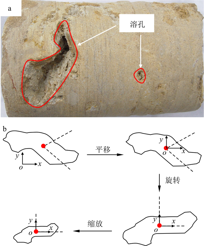
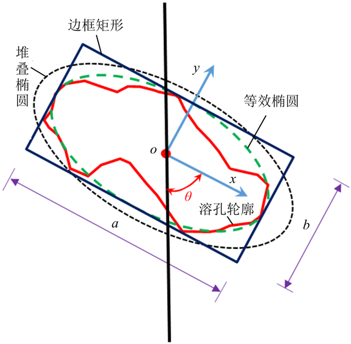
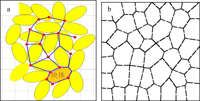
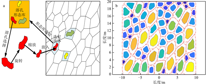
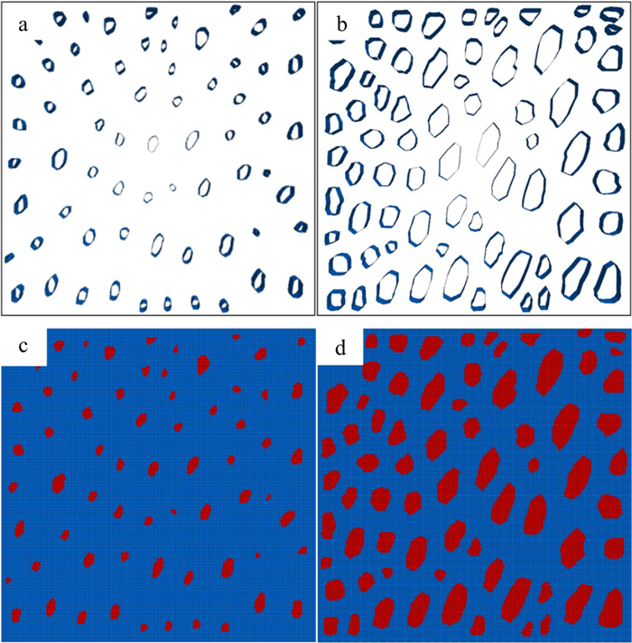
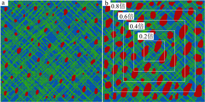
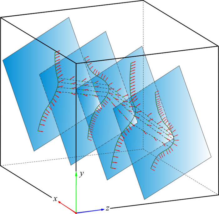
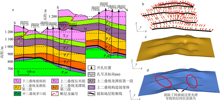
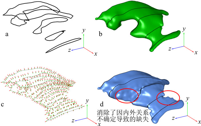
Methods

The karst fractured aquifer has the characteristics of composite network. At present, the numerical simulation method is mainly used to resolve this kind of problem. However, most of the existing numerical models only simulate the fracture network of aquifer, ignoring the karst phenomena such as dissolved pores with stochastic distribution, which is different from the practice. Therefore, this paper focuses on the simulation of randomly distributed dissolution pores in limestone aquifers, and combines them with the existing fracture network to obtain a more accurate karst featured aquifer network model, then convert it into a numerical ones. For this reason, firstly, some drilling and outcrop data are selected, and the contour of dissolved pores is depicted by AutoCAD software to establish corresponding morphological library, which provides sufficient samples for the stochastic generation of dissolved pore. When there are enough dissolved pore samples, the authenticity of the morphological library of dissolved pores are maintained. Secondly, the multi-factor directional block cutting technology is used to establish a storage space for the subsequent random dissolved pores. The dissolved pores are randomly extracted from corresponding morphological library, after scaling and rotating these samples into the storage space according to a certain scaling ratio, and finally the stochastic generation of dissolved pores can be realized. Subsequently, superimposed it with the fracture network generation based on the Monte Carlo method to obtain a randomly generated limestone aquifer composite grid model with a certain dissolved porosity, fracture density and spacing. Finally, the network model is transformed into FLAC3D numerical gird based on AutoCAD software, and the numerical model of limestone can be established.
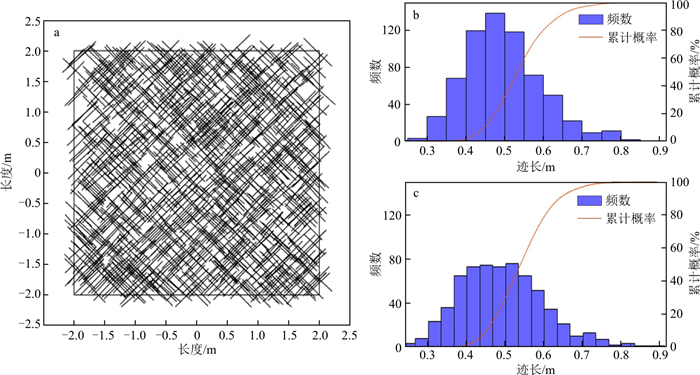
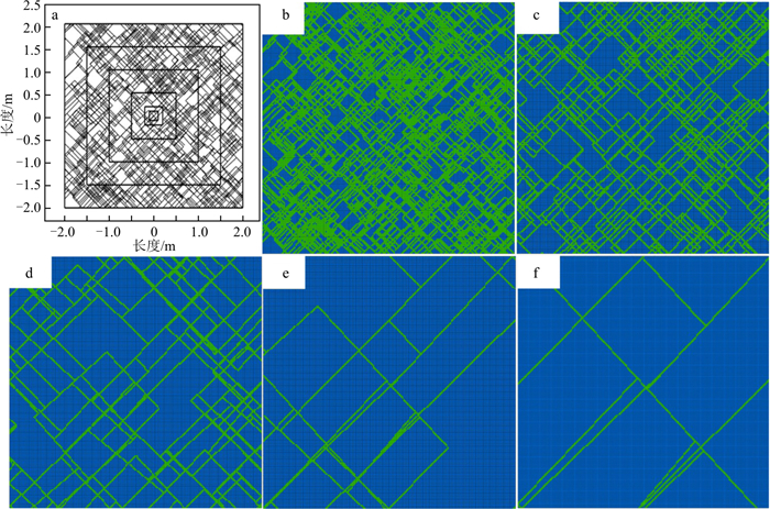
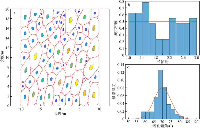
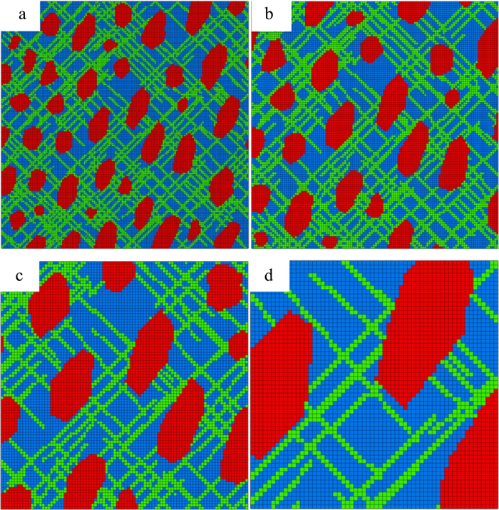
Results

According to the above method, the composite network model of limestone aquifer with different solution porosity, fracture density and spacing can be generated. The density and ductility of the fractures in the fracture network are labelled as low, moderately low, medium, moderately high and high respectively. The dissolution rate of dissolved pore is classified into 0.05, 0.10, 0.15, 0.20, 0.25 and 0.35 respectively. Taking high density-low ductility fracture network as an example. Two models with dissolved pore rate of 0.05 and 0.25 are superimposed, and statistial analysis was carried out on the trace length of fracture, long axis ratio and dip angle of dissolved pore. The obtained results are in line with expectations, which proves the effectiveness of the generated model.

Conclusion

The research results have certain significance for the establishment of three-dimensional random dissolution pore model, and lay a foundation for the subsequent analysis of seepage characteristics of karst fracture aquifer based on numerical simulation.

Application of three-dimensional visualization modeling technology of ore bodies in metallogenic mode analysis
Tang Ji, Jiang Xiao, Jiang Xuelian, Bao Jinkun, Yao Lixiang, Xi Wanxin
2023, 42(5): 273-284. doi: 10.19509/j.cnki.dzkq.tb20220581
Abstract:
Objective

Copper is an important strategic metal resource for national economic and social development. Therefore, the exploration and resource assessment of copper mines are of great significance.

Methods

Based on collected geological profiles and drilling data, this study constructed a three-dimensional geological model for a copper ore deposit in western Yunnan, which was applied to estimate the resource reserve in the mining area.

Results

The ore resource is estimated to be 48.93 million tons, including 0.543 million tons of copper. Through comparative analysis, the model and resource estimation established by our newly proposed three-dimensional geological modelling system shows high credibility, in which multiple analysis modules and dynamic update function have a wide range of applications and it can be used for future drilling engineering and resources estimation.

Conclusion

This study provides the basis for further exploration work in this region, and it can also be applied to the exploration and mining of related polymetallic deposits.

Multiparameter reservoir evaluation method based on unsupervised learning: A case study of the reef beach reservoir of the Lower Triassic Feixianguan Formation in the Pubaoshan area
Li Yang, Dai Zongyang, Zhang Jiewei, Xiao Duoyan, Li Dan, Zhao Xiaoyang, Li Tian, Huang Lan, Huang Youlin
2023, 42(5): 285-292. doi: 10.19509/j.cnki.dzkq.2022.0154
Abstract:
Objective

The formation and development of the reef-shoal reservoirs in the Lower Triassic Feixianguan Formation in the Pobaoshan area are the result of the comprehensive action of the geological historical period. Therefore, only using a single factor in reservoir evaluation will inevitably lead to deviations.

Methods

The k-means cluster analysis method and principal component analysis method were used to classify and evaluate the reservoir in the study area.

Results

The results show that: On the premise that three different influencing factors of dolomite thickness, average porosity and effective reservoir thickness of the Lower Triassic Feixianguan Formation reef-shoal reservoir in the Pubaoshan area are known, gridding different planes to extract reservoir characteristic data of different influencing factors. The combined elbow method and contour method are used to analyze reservoir characteristic data and divide the reservoir into 4 development types. Then k-means cluster analysis method is applied to assign class attributes to the known data points. Using principal component analysis to reduce the dimensionality of different reservoir characteristic data to form a new comprehensive parameter. The parameter contribution rate can reach 0.882. According to the classification results of k-means, the mean values of the comprehensive parameters of different types of principal component analysis of the four reservoirs were calculated, which were 0.404, 0.640 and 0.716, respectively, as the demarcation point of the reservoir evaluation zone. Finally, this quantitative method is used to reasonably integrate the different characteristic plans of the study area to form a comprehensive evaluation map of the reservoir.

Conclusion

The research results can effectively classify and evaluate the reservoir in the study area and predict favorable exploration areas.

Three-dimensional geological implicit surface reconstruction based on intermediate contour morphological interpolation
Wang Quan, Zou Yanhong
2023, 42(5): 293-300. doi: 10.19509/j.cnki.dzkq.tb20220003
Abstract:
Objective

In three-dimensional morphological reconstruction of complex geological surfaces, the sparse geological section data cannot meet the modelling requirements. To overcome it, in this paper, we propose a 3D geological implicit surface reconstruction method based on intermediate contour morphological interpolation at the maximum similarity.

Methods

Firstly, a fuzzy vertex correspondence algorithm was used to generate multiple contour vertex mapping sets of two adjacent contours of the same geological body. Then, the contour similarity coefficient was obtained by calculating the similarity degree of matching points, and the best contour vertex matching map is established based on maximum similarity matching principle; Finally, through intermediate gradient interpolation, the result is used as a morphological constraint to participate in surface reconstruction with radial basis functions (RBFs).

Results

Taking the practical geological section as an example, we constructed the three-dimensional geological implicit model based on morphological interpolation.

Conclusion

Results show that the proposed method can not only realize reasonable intermediate morphology transition between two adjacent sparse contours, but also overcome the phenomenon of excessively smooth or discontinuous surfaces caused by sparse data during implicit surface reconstruction, providing a new basis for complex geological surface reconstruction based on implicit functions.