| Citation: | WANG Quanjuan, SUN Jingfeng, YANG Yingjie, ZHANG Jiangwei, WANG Guoliang, MA Enze, LIU Jin, ZHAO Xin. A comparative study of Kriging and deep learning methods for shallow groundwater level estimation: A case study of the Shenzhen-Shanwei Special Cooperation Zone[J]. Bulletin of Geological Science and Technology, 2024, 43(4): 291-301. doi: 10.19509/j.cnki.dzkq.tb20230192

|
Knowledge of the regional groundwater level is an important foundation for groundwater resource evaluation and protection. Due to the limited amount of groundwater level data available at the regional scale, Kriging interpolation and deep learning methods are gradually being used for regional groundwater level prediction, but their applicability and robustness lack comparative analysis.
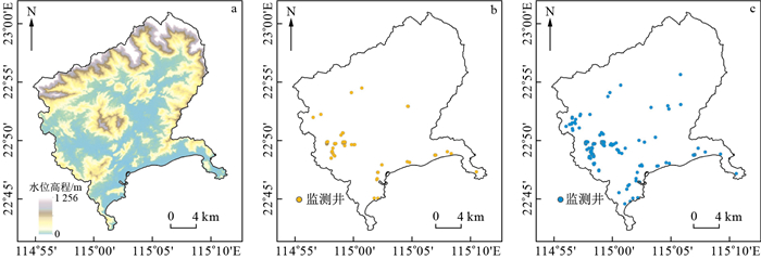
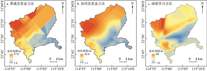
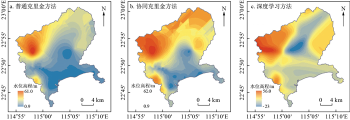
In this paper, spatial interpolation of groundwater levels in the Shenzhen-Shanwei Special Cooperation Zone was carried out using ordinary Kriging, coKriging and deep learning methods to explore the potential of these three methods for practical application to regional groundwater level prediction. To investigate the effect of the training set sample size on the prediction effect of the three methods, 239 monitoring wells were divided into two groups of 76 and 163 wells for the training of the three models.
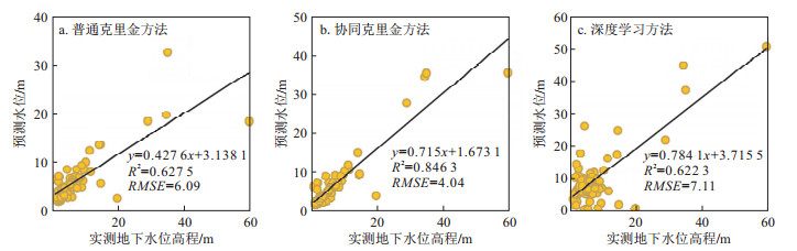
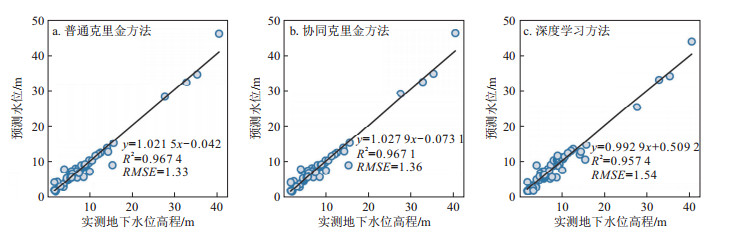
The results showed that the RMSEs were 6.09, 4.04, and 7.11 when the training data of 76 wells were used to fit the validation set, and the Kriging method, which accounts for surface elevation information, was significantly better than the ordinary Kriging method and the deep learning method. In addition, the predicted water level distribution improved when a larger number of samples was used to predict the water level in the region. However, the spatial distribution characteristics still differed significantly.
The results show that when the observation data are sparse, the prediction effect of coKriging with elevation information is significantly greater than that of ordinary Kriging and deep learning methods, while the RMSEs obtained by the three methods are similar when the amount of observation data increases to a certain amount.

| [1] |
THEODOSSIOU N, LATINOPOULOS P. Evaluation and optimization of groundwater observation networks using the kriging methodology[J]. Environmental Modelling & Software, 2006, 21(7): 991-1000.
|
| [2] |
KUMAR V. Optimal contour mapping of groundwater levels using universal kriging: A case study[J]. Hydrological Sciences Journal, 2007, 52(5): 1038-1050. doi: 10.1623/hysj.52.5.1038
|
| [3] |
VAROUCHAKIS E A, HRISTOPULOS D T, KARATZAS G P. Improving kriging of groundwater level data using nonlinear normalizing transformations: A field application[J]. Hydrological Sciences Journal, 2012, 57(7): 1404-1419. doi: 10.1080/02626667.2012.717174
|
| [4] |
VAROUCHAKIS E A, HRISTOPULOS D T. Comparison of stochastic and deterministic methods for mapping groundwater level spatial variability in sparsely monitored basins[J]. Environmental monitoring and Assessment, 2013, 185: 1-19. doi: 10.1007/s10661-012-2527-y
|
| [5] |
BORONINA A, CLAYTON R, GWYNNE C. Recommended methodology for determination of design groundwater levels[J]. Australian Geomechanics Journal, 2015, 50(3): 11-21.
|
| [6] |
SIMO A T G, MARACHE A, LASTENNET R, et al. Geostatistical investigations for suitable mapping of the water table: The Bordeaux case (France)[J]. Hydrogeology Journal, 2016, 24(1): 231. doi: 10.1007/s10040-015-1316-4
|
| [7] |
ZIRAKBASH T, ADMIRAAL R, BORONINA A, et al. Assessing interpolation methods for accuracy of design groundwater levels for civil projects[J]. Journal of Hydrologic Engineering, 2020, 25(9): 04020042. doi: 10.1061/(ASCE)HE.1943-5584.0001982
|
| [8] |
DELHOMME J P. Kriging in the hydrosciences[J]. Advances in Water Resources, 1978, 1(5): 251-266. doi: 10.1016/0309-1708(78)90039-8
|
| [9] |
DUNLAP L E, SPINAZOLA J M. Interpolating water-table altitudes in west-central Kansas using kriging techniques[M]. Department of the Interior, US Geological Survey, 1984.
|
| [10] |
NEUMAN S P, JACOBSON E A. Analysis of nonintrinsic spatial variability by residual kriging with application to regional groundwater levels[J]. Journal of the International Association for Mathematical Geology, 1984, 16: 499-521. doi: 10.1007/BF01886329
|
| [11] |
AHMADI S H, SEDGHAMIZ A. Geostatistical analysis of spatial and temporal variations of groundwater level[J]. Environmental Monitoring and Assessment, 2007, 129: 277-294. doi: 10.1007/s10661-006-9361-z
|
| [12] |
CHUNG J, ROGERS J D. Interpolations of groundwater table elevation in dissected uplands[J]. Groundwater, 2012, 50(4): 598-607. doi: 10.1111/j.1745-6584.2011.00889.x
|
| [13] |
王卫光, 薛绪掌, 耿伟. 河套灌区地下水位的空间变异性及其克里金估值[J]. 灌溉排水学报, 2007(1): 18-21. https://www.cnki.com.cn/Article/CJFDTOTAL-GGPS200701004.htm
WANG W G, XUE X Z, GENG W. Spatial variability of water level in Hetao Irrigation District of Inner Mongolia and their estimations by the kriging[J]. Journal of Irrigation and Drainage, 2007(1): 18-21. (in Chinese with English abstract) https://www.cnki.com.cn/Article/CJFDTOTAL-GGPS200701004.htm
|
| [14] |
刘治政, 吴晓东, 林洪孝. Kriging插值模型在地下水位监测网优化中的应用[J]. 人民长江, 2010, 41(9): 14-17. https://www.cnki.com.cn/Article/CJFDTOTAL-RIVE201009005.htm
LIU Z Z, WU X D, LIN H X. Kriging interpolation model and its application in optimization of groundwater level monitoring network[J]. Yangtze River, 2010, 41(9): 14-17. (in Chinese with English abstract) https://www.cnki.com.cn/Article/CJFDTOTAL-RIVE201009005.htm
|
| [15] |
李江, 郝新梅, 范琳琳, 等. 黑河中游绿洲地下水位空间变异性研究[J]. 水力发电学报, 2015, 34(11): 106-115. https://www.cnki.com.cn/Article/CJFDTOTAL-SFXB201511012.htm
LI J, HAO X M, FAN L L, et al. Spatial variability of groundwater level in midstream oasis of Heihe River basin[J]. Journal of Hydroelectric Engineering, 2015, 34(11): 106-115. (in Chinese with English abstract) https://www.cnki.com.cn/Article/CJFDTOTAL-SFXB201511012.htm
|
| [16] |
HOEKSEMA R J, CLAPP R B, THOMAS A L, et al. Cokriging model for estimation of water table elevation[J]. Water Resources Research, 1989, 25(3): 429-438. doi: 10.1029/WR025i003p00429
|
| [17] |
DESBARATS A J, LOGAN C E, HINTON M J, et al. On the kriging of water table elevations using collateral information from a digital elevation model[J]. Journal of Hydrology, 2002, 255(1/4): 25-38.
|
| [18] |
AHMADI S H, SEDGHAMIZ A. Application and evaluation of kriging and cokriging methods on groundwater depth mapping[J]. Environmental Monitoring and Assessment, 2008, 138: 357-368. doi: 10.1007/s10661-007-9803-2
|
| [19] |
GUZMAN S M, PAZ J O, TAGERT M L M. The use of NARX neural networks to forecast daily groundwater levels[J]. Water Resources Management, 2017, 31: 1591-1603. doi: 10.1007/s11269-017-1598-5
|
| [20] |
JEONG J, PARK E. Comparative applications of data-driven models representing water table fluctuations[J]. Journal of Hydrology, 2019, 572: 261-273. doi: 10.1016/j.jhydrol.2019.02.051
|
| [21] |
JEONG J, PARK E, CHEN H, et al. Estimation of groundwater level based on the robust training of recurrent neural networks using corrupted data[J]. Journal of Hydrology, 2020, 582: 124512. doi: 10.1016/j.jhydrol.2019.124512
|
| [22] |
ZHANG A, WINTERLE J, YANG C. Performance comparison of physical process-based and data-driven models: A case study on the Edwards Aquifer, USA[J]. Hydrogeology Journal, 2020, 28(6): 2025-2037. doi: 10.1007/s10040-020-02169-z
|
| [23] |
MÜLLER J, PARK J, SAHU R, et al. Surrogate optimization of deep neural networks for groundwater predictions[J]. Journal of Global Optimization, 2021, 81: 203-231. doi: 10.1007/s10898-020-00912-0
|
| [24] |
WUNSCH A, LIESCH T, BRODA S. Groundwater level forecasting with artificial neural networks: A comparison of long short-term memory (LSTM), convolutional neural networks (CNNs), and non-linear autoregressive networks with exogenous input (NARX)[J]. Hydrology and Earth System Sciences, 2021, 25(3): 1671-1687. doi: 10.5194/hess-25-1671-2021
|
| [25] |
刘攀, 郑雅莲, 谢康, 等. 水文水资源领域深度学习研究进展综述[J]. 人民长江, 2021, 52(10): 76-83. https://www.cnki.com.cn/Article/CJFDTOTAL-RIVE202110012.htm
LIU P, ZHENG Y L, XIE K, et al. Review of research progress in deep learning for hydrology and water resources[J]. Yangtze River, 2021, 52(10): 76-83. (in Chinese with English abstract) https://www.cnki.com.cn/Article/CJFDTOTAL-RIVE202110012.htm
|
| [26] |
WUNSCH A, LIESCH T, BRODA S. Deep learning shows declining groundwater levels in Germany until 2100 due to climate change[J]. Nature Communications, 2022, 13(1): 1221. doi: 10.1038/s41467-022-28770-2
|
| [27] |
ZHANG J, ZHU Y, ZHANG X, et al. Developing a long short-term memory (LSTM) based model for predicting water table depth in agricultural areas[J]. Journal of Hydrology, 2018, 561: 918-929. doi: 10.1016/j.jhydrol.2018.04.065
|
| [28] |
KUMAR D, ROSHNI T, SINGH A, et al. Predicting groundwater depth fluctuations using deep learning, extreme learning machine and Gaussian process: A comparative study[J]. Earth Science Informatics, 2020, 13: 1237-1250. doi: 10.1007/s12145-020-00508-y
|
| [29] |
TAO H, HAMEED M M, MARHOON H A, et al. Groundwater level prediction using machine learning models: A comprehensive review[J]. Neurocomputing, 2022, 489: 271-308. doi: 10.1016/j.neucom.2022.03.014
|
| [30] |
黄宇, 杨荣森, 韩晓东, 等. 基于定向半变异函数的裂隙网络空间变异性分析[J]. 地质科技通报, 2023, 42(2): 186-193. doi: 10.19509/j.cnki.dzkq.2022.0248
HUANG Y, YANG R S, HAN X D, et al. Analysis of the spatial variability on a fracture network based on an oriented semivariogram[J]. Bulletin of Geological Science and Technology, 2023, 42(2): 186-193. (in Chinese with English abstract) doi: 10.19509/j.cnki.dzkq.2022.0248
|
| [31] |
薛佩佩, 文章, 梁杏. 地质统计学在含水层参数空间变异研究中的应用进展与发展趋势[J]. 地质科技通报, 2022, 41(1): 209-222. 10.19509/j.cnki.dzkq.2022.0015
XUE P P, WEN Z, LIANG X. The application progress and development trend of geostatistics in the study of aquifer parameter spatial variation[J]. Bulletin of Geological Science and Technology, 2022, 41(1): 209-222. (in Chinese with English abstract) 10.19509/j.cnki.dzkq.2022.0015
|
Copyright © 2010Editorial Department of Bulletin of Geological Science and Technology

Supported by:
Beijing Renhe Information Technology Co., Ltd.


 DownLoad: