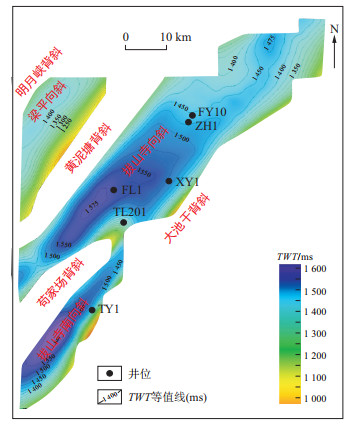
Current Issue

2024 Vol. 43, No. 4

Display Method:
Research status and significance of shale oil micromigration
WEN Jie, XU Shang, GOU Qiyang, ZHAO Tongxu, WANG Yufan, LIU Bingchang, WEN Kang
2024, 43(4): 1-14. doi: 10.19509/j.cnki.dzkq.tb20240034
Abstract:
Significance

The micromigration of shale oil refers to the phenomenon in which oil is generated in organic-rich layers and expelled at short distances to adjacent, preferable porous and permeable, organic-lean layers in shale systems. Micromigration can effectively improve the oil content and quality of organic-lean layers, even surpassing some organic-rich shale layers based on the exploration practices. Therefore, it is necessary to conduct a systematic study on the micromigration phenomenon of shale oil.

Progress

Based on the current research progress, this paper first identifies the main tracers of shale oil micromigration, which include rock pyrolysis parameters, hydrocarbon components, biomarkers, NSO compounds, as well as isotopes. The fundamental principle relies on fractionation between migrated hydrocarbons and retained hydrocarbons based on their geochemical properties. Analysis revealed that micromigration can lead to a dispersed distribution of hydrocarbon generation activation energy in organic-lean shale layers, resulting in an earlier hydrocarbon generation threshold. Moreover, the accumulation of light hydrocarbons in a free state in organic-lean layers can further increase the difference of hydrocarbon components between generative units and in-source reservoirs, thereby affecting the oil-bearing and mobility characteristics of shale. Based on the effects of petroleum migration and geological zonation, this paper reveals that micromigration occurs throughout the entire process of hydrocarbon generation, expulsion, and retention. It serves as a bridge connecting all elements of petroleum accumulation within shale systems, influencing the differential enrichment of shale oil.

Conclusions and Prospects

Comprehensive geochemical and geophysical methods are effective ways to identify micromigration in shale systems and will provide a new perspective for revealing the dynamic differential enrichment of lacustrine shale oil.

Analysis of the formation conditions of Mesozoic secondary oil and gas reservoirs in Halahatang-Hade area of the Tabei Uplift
SHI Fang, WANG Zhukun, LI Jianlang, SUN Qi, YI Zhenli, LI Bin, LIU Liu, YIN Taiju
2024, 43(4): 15-26. doi: 10.19509/j.cnki.dzkq.tb20230449
Abstract:
Objective

The Mesozoic strata in the Halahatang-Hade area of the Tabei Uplift belt, Tarim Basin, cover an area of more than 30 000 km2. It has a large monoclinic background, with active hydrocarbon displays and great exploration potential, but no exploration breakthrough have been made for many years. The discovery of the adjacent SINOPEC mining area promoted exploration in the area.

Methods

Based on the newly obtained 3D seismic data and a regional geological overview, the oil source conditions, structural and evolutionary characteristics of strike-slip faults, and formation and sealing conditions of lithologic traps were systematically analysed, and the reservoir formation pattern and favourable exploration directions in this area were clarified.

Results

In this area, fluvial-delta sedimentary systems developed in the Mesozoic, including a NE-SW-trended delta sand-body developed during the Triassic, the SE-NW-directed shallow water delta sand-bodies developed during the Early Jurassic and Cretaceous, and a large scale of continuous braided river sand-body developed during Late Cretaceous. The study area had experienced three uplift episodes and five faulting episodes. The Triassic-Jurassic fault system accompanied by the Palaeozoic fault system show NE-SW-striked in echelon. The front edge of the Cretaceous and Jurassic shallow water deltas was spliced with a single body or multiple bodies covered with mudstone to form lateral occlusion, which combined with an upwards-dipping fault to form a lithology-fault trap. The Triassic striped sand-body spread in the southeast direction and formed lithology, and the mudstone shading outside the channel at the bend of the large river channel formed a lithological trap. Hydrocarbon sourced from Palaeozoic palaeo-accumulations, migrated through Palaeozoic-Ordovician faults, and directly or successively charged into the Mesozoic trap through the Mesozoic fault.

Conclusion

Based on the hydrocarbon accumulation model, it is believed that the potential exploration areas in the study area mainly include the Jurassic-Cretaceous Shushan River formation Delta front lithological reservoir of the northern strike-slip zone, the delta front sand-body on the north side of the Triassic, and the southern channel sand-body lithological trap, and the northern Triassic descending area covered with small fan lithological traps. The three controlling factors, fault assemblage, sand-body distribution, and mantled mudstone shielding, and their effective allocation are important for guaranteeing the formation of favourable lithologic and lithologic fault combination traps in the large slope areas of the Tabei Uplift belt. The research results point out the direction of further hydrocarbon exploration in this area and are important for guiding hydrocarbon reservoir exploration of lithologic and lithologic fault combination traps in other areas.

A new method for predicting shale pore pressure: A case study of the Bodong Depression in the Bohai Bay Basin
ZHANG Suisui, FAN Changyu, WANG Deying, CHEN Lei, WANG Qiming, WANG Zhenliang, WANG Feilong, YAN Xinyu
2024, 43(4): 27-38. doi: 10.19509/j.cnki.dzkq.tb20230638
Abstract:
Objective

China's oil and gas exploration is advancing towards the field of shale oil and gas. Overpressure is commonly developed in organic shale, and the lack of prediction methods for shale pore pressure restricts the research on shale oil and gas.

Methods

This article analyses the physical response characteristics of rock to hydrocarbon generation, pressurization and disequilibrium compaction. Based on density and sound velocity data, the differential responses of hydrocarbon generation pressurization and disequilibrium compaction pressurization were analysed. The hydrocarbon generation pressurization amount is calculated using sound velocity and density, and the disequilibrium compaction is calculated using the density data. Finally, the sound velocity rebound method was established. This article selects the Bodong Depression, which has superior hydrocarbon generation conditions, as a case study. First, comprehensive mudstone compaction curves, loading-unloading curves, and sound velocity-density diagrams are used to comprehensively identify the cause of overpressure. Then, the sound velocity rebound method is used to quantitatively calculate the pressure increase and formation pore pressure of a single well under compaction and hydrocarbon generation, and the results are compared with those of numerical simulations and conventional calculation methods.

Results

Taking the LD21-A well as an example, shale overpressure is caused by a combination of hydrocarbon generation and disequilibrium compaction. The pressure prediction results show that the overpressure of nonsource rock layers is contributed by the disequilibrium compaction. The overpressure of the source rock formation is contributed by hydrocarbon generation and disequilibrium compaction, with hydrocarbon generation pressurization mainly distributed between 5 MPa and 15 MPa (accounting for approximately 35% to 65%), and the measured pressure point hydrocarbon generation pressurization is 11.09 MPa (accounting for 45%).

Conclusion

This new method is vital of importance for the research of both shale and conventional oil and gas fields.

Relationship between structure and evolution of the Early Carboniferous rifted basin and shale gas preservation: A case study of the Rongshui area in the Guizhong Depression
CEN Wenpan, QIN Yinglun, WANG Xiang, XIONG Weiwei, HUANG Wenfang, ZHUO Seqiang
2024, 43(4): 39-52. doi: 10.19509/j.cnki.dzkq.tb20230723
Abstract:
Objective

Many important discoveries have been made in shale gas exploration in the Lower Carboniferous Luzhai Formation in the central and northern Guizhong Depression, southern margin of the Xuefengshan Uplift, and commercial test production has achieved successful gas ignition. However, the structure and evolution of the depression in this area have not been clearly defined, which restricts an accurate understanding of the formation conditions for organic-rich mud shale, the distribution of favourable sedimentary facies zones, and shale gas enrichment law.

Methods

Taking the Rongshui area as an example, this paper studies the main structures and their relationships with shale gas preservation through geological investigation and analysis, 2D-3D seismic section structural interpretation, evolutionary equilibrium section interpretation and other technologies.

Results

It is believed that there are three main faults and four main NE-NNE synclines in the study area. The preexisting NNE-trending Sanjiang-Rong'an fault is the main factor involved in extensional fault depression and compression-strike-slip transformation. In the study area, the extensional fault depression developed in the Late Devonian, strengthened in the Early Carboniferous and stopped in the late Early Carboniferous. The compression-strike-slip effect of the depression reconstruction developed in the Indochinese and Yanshanian stages, and the local tensioning effect developed in the Alpine stage. The main part of the present fold system was formed in the Indosinian period. Influenced by the increasing thrust of the Sanjiang-Rong'an fault from west to east, the structure pattern of broad and slow synclinal-compound synclinal-faulted folds is distributed. Complex synclines are favourable structural units for shale gas preservation, and the favourable structural styles for shale gas preservation are synclines and anticlines.

Conclusion

This understanding clearly defines the direction of shale gas exploration and deployment in the next step, and provides a beneficial idea for the structure and evolution of the Liucheng slope in the north-central part of the Guizhong Depression.

Development geology avaluation of normal-pressured shale gas in the Baima area, eastern margin of the Sichuan Basin
LIU Chao, BAO Hanyong, WAN Yunqiang
2024, 43(4): 53-61. doi: 10.19509/j.cnki.dzkq.tb20230648
Abstract:
Objective

The Fuling Gas Field as the first commercial shale gas field in China has stably achieved an annual gas production of over 7 billion cubic meters in recent years, which is a good development result. With the increasing demand for development, the development targets have gradually shifted from the high-pressured shale gas reservoirs, e.g., the Jiaoshiba region, to the normal-pressured shale gas reservoirs of the Baima region. In 2021, the Baima area submitted a proven reserve of 104.883 billion cubic meters, consolidating its geological resource foundation. Development geology evaluation and target optimization are the first steps to efficiently achieve the utilization of reserves.

Methods

Based on core testing, well logging interpretation, seismic prediction, and gas testing data, the favourable intervals and targets for the development of normal-pressured shale gas in the Baima area were evaluated in this study.

Results

The research results indicate that the organic-rich shale of the Ordovician Wufeng Formation and Silurian Longmaxi Formation in the Baima area was deposited on the deep-water shelf. Thereinto, the deep-water shelf siliceous shale is the most favourable layer for development. The key parameters for the development geology evaluation of normal-pressured shale gas include the formation pressure coefficient, porosity, natural fractures, and stress properties.

Conclusion

A geological parameter system has been established for the development of target areas, which suggests that the southern part of the Baima Syncline can be selected as the first target for development and production. The Baima Region has achieved large-scale economic production and can be an important reference for the development of normal-pressured shale gas.

Characteristics of the shale sedimentary environment and organic matter enrichment mechanism in the Jurassic Lianggaoshan Formation in the East Sichuan Basin
GUO Zhanfeng, SHU Yi, CHEN Miankun, LIU Haotian, PENG Wei, XIAO Xiong
2024, 43(4): 62-74. doi: 10.19509/j.cnki.dzkq.tb20230727
Abstract:
Objective

The good oil test results of Taiye 1 and Xingye L1 wells in the Jurassic Lianggaoshan Formation shale indicate the breakthrough of shale oil/gas exploration in the Jurassic continental shale in the Fuxing area of the eastern Sichuan Basin. To further clarify the oil/gas exploration potential and the organic matter enrichment mechanism of the Jurassic Lianggaoshan Formation shale, utilizing logging and core data of two typical wells Xingye X and Xingye Y, the whole-rock X-ray diffraction, organic carbon, major and trace elements were analyzed.

Methods

The Liang-2 lower submember was deposited in the environment of warm-wet (moderate weathering conditions) and freshwater, and there was no obvious difference in palaeoclimates of different unit formations. The La-Co data suggests a semi-deep to deep lake environment with a palaeowater depth ranging from 10.9 to 56.1 m; the anoxic reducing environment persisted on the lake floor despite the lake level fluctuation, but the palaeoproductivity was vertically increased. The shale interval is rich in sandy laminae, but the deposition rate of the shale layer is lower than that of the sandstone layer.

Results

According to the correlation analysis between sedimentary environment parameters and organic carbon content (TOC), the organic matter enrichment in the Liang-2 lower submember shale was mainly controlled by factors of palaeowater depth, palaeoredox environment, deposition rate, and palaeoproductivity, and slightly affected by the palaeosalinity and palaeoclimate conditions. The variation in the deposition environment resulted in the vertical heterogeneity of shale.

Conclusion

The shale facies of Unit 6, formed in the good conditions for the organic matter enrichment referring to an anoxic environment in deep water, with a low deposition rate, a high palaeoproductivity, and the slight influence of terrigenous sources, was a favorable target layer for exploration.

Geophysical characterization of complex geopressure systems in unconventional reservoirs: A case study of the Jurassic reservoir in the Fuxing area
LUO Bing, ZHANG Daohong, LIU Qijun, CHEN Aiqiong
2024, 43(4): 75-86. doi: 10.19509/j.cnki.dzkq.tb20240129
Abstract:
Objective

The prediction of abnormal formation pressure is a challenging issue in oil and gas development. With the continuous development of unconventional reservoirs such as shale gas and tight sandstone gas, the complexity of geopressure systems has increased. The coexistence of overpressure and underpressure in the same area often occurs, making it important to accurately characterize complex pressure systems.

Methods

In this work, two sets of overpressure systems and one set of underpressure systems formed in the Jurassic shale gas reservoir and tight sandstone reservoir in the Fuxing area were analysed. The geophysical responses and sensitive elastic parameters of overpressure and underpressure were analysed. The bulk modulus of the mudstone formation was strongly correlated with the formation pressure over the underpressure-overpressure interval. Based on this, an integrated prediction method for overpressure and underpressure based on the bulk modulus of mudstone was proposed and applied in this area by using well log and seismic data. The key of this method is to use the mudstone of overpressure and underpressure formations for integrated pressure prediction, reducing the influence of lithological changes. Second, the bulk modulus, which is directly related to the physical mechanism of abnormal pressure, was selected as the input parameter to improve the accuracy.

Results

According to the results of pressure prediction in the study area, the preservation conditions of the strong overpressure system in the Dongyuemiao Member are good, the pressure structure is stable, and the maximum pressure coefficient is approximately 2.0. The preservation conditions of the overpressure system in the Lianggaoshan Formation are relatively poor, with large lateral differences in pressure structure characteristics, and the maximum pressure coefficient is approximately 1.65; the pressure coefficient of the underpressure system in the Lianggaoshan Formation is approximately 0.5 to 1.0, and it has a certain coupling effect with the underlying overpressure system.

Conclusion

The predictions of overpressure and underpressure using well logs and seismic data in the study area both achieved high agreement with the measured data.

Response characteristics and mechanism for fracturing interference of adjacent wells of shale gas wells: A case study in the Fuling shale gas field
SHEN Jincai
2024, 43(4): 87-97. doi: 10.19509/j.cnki.dzkq.tb20230643
Abstract:
Objective

Regarding conventional gas resources, research on the fracturing interference of adjacent wells has focused mainly on interference during the production process; the interference of adjacent wells is usually avoided by determining the rational spacing between wells, and the radius of influence is the key to determining a reasonable well spacing. The fracturing interference of shale gas adjacent wells involves various types, phenomena, results and control factors; however, there is no generally accepted description method or mechanism for studying the response characteristics of the fracturing interference of adjacent wells.

Methods

The Fuling shale gas field is taken as an example to discuss the response characteristics and mechanism of the fracturing interference of adjacent wells in shale gas.

Results

According to the impact on the recoverable reserves of parent wells, the fracturing interference of shale gas adjacent wells can be divided into three types: positive interference, noninterference and negative interference. The three types of interference are mainly related to the spacing of the child and parent wells, crossing layers, recovery percentage, formation pressure, stress difference and other factors. The closer the spacing and crossing layers between wells are, the greater the recovery degree of the parent wells or the lower the formation pressure is, the greater the difference between both sides of the stress of the child well becomes, and the greater the fracturing interference becomes. On the basis of the different results caused by fracturing interference, to avoid negative effects, shale gas development requires the formulation of reasonable well spacings, the shuttling of parent wells to restore the pressure until it stabilizes before fracturing, and the use of diverters during fracturing of new child wells. The generation mechanisms of fracturing interference are the degree of fracture and the overlap of artificial fracturing networks between child wells and parent wells. The ideal situation is that the fracturing network edge of the child wells just reaches the fracturing network edge of the older parent wells, which has a positive effect on increasing production; however, the noninterference type does not occur when the child wells' SRV is insufficient, nor does the negative interference type occur when the fracturing networks are connected between the child wells and parent wells.

Conclusion

The research results provide theoretical support for formulating reasonable fracturing interference prevention measures and have good guiding significance in industry.

Enrichment conditions and main controlling factors of continental shale gas in the Permian Lower Wuerhe Formation in the Dongdaohaizi Sag, Junggar Basin
WANG Daxing, HU Haiyan, ZOU Jiaqun, WANG Tao, ZHU Gengen, CHEN Xiaoyu, LIANG Shuo
2024, 43(4): 98-112. doi: 10.19509/j.cnki.dzkq.tb20230184
Abstract:
Objective

To explore the enrichment conditions and main controlling factors of shale gas in the Lower Wuerhe Formation of the Permian System in the Junggar Basin, the Lower Wuerhe Formation in the Dongdaohaizi Sag was selected as the research object.
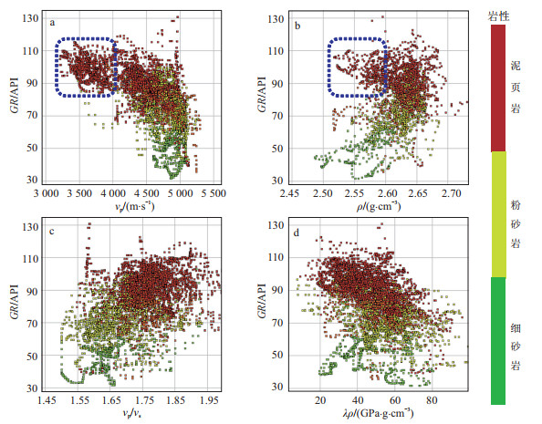
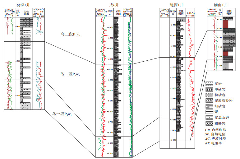
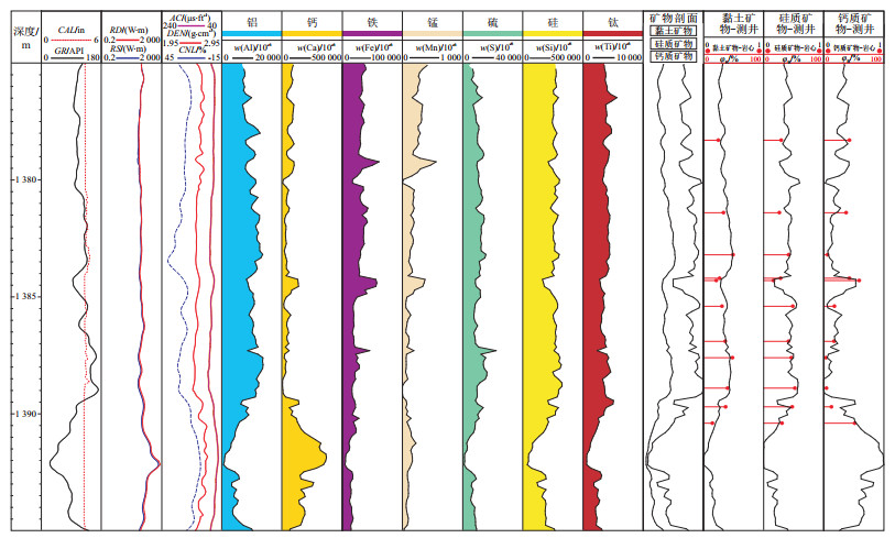
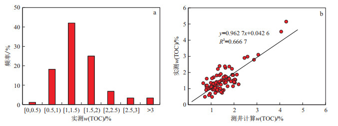
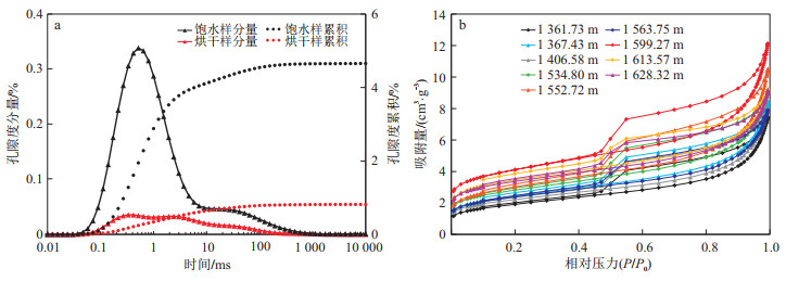
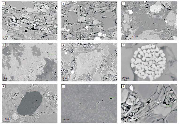
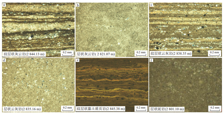
Methods

Based on the data of outcrop, core, well logging, well-calibrated seismic reflections and the technologies of total organic carbon (TOC) content determination, whole-rock X-ray diffraction, gas adsorption (N2, CO2), the distribution characteristics, organic matter development characteristics, reservoir characteristics, and gas bearing characteristics of the Lower Wuerhe Formation shale were studied.
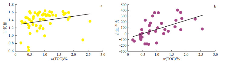
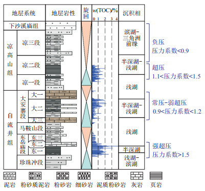
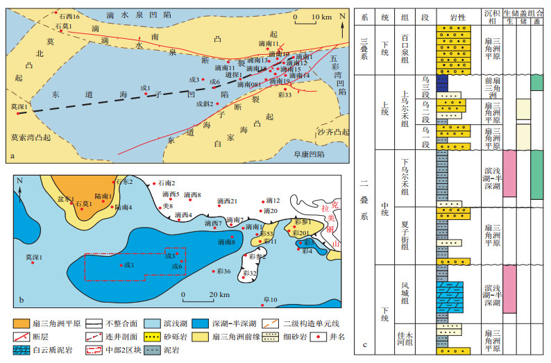
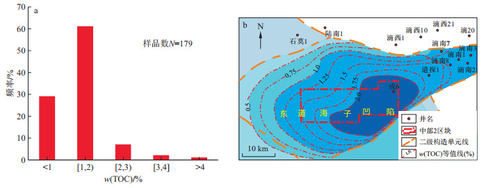
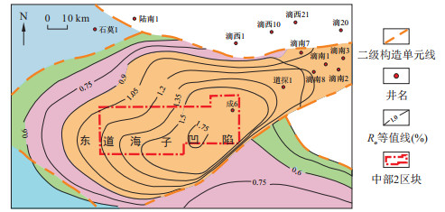
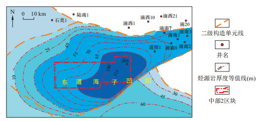
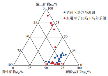
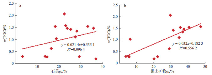
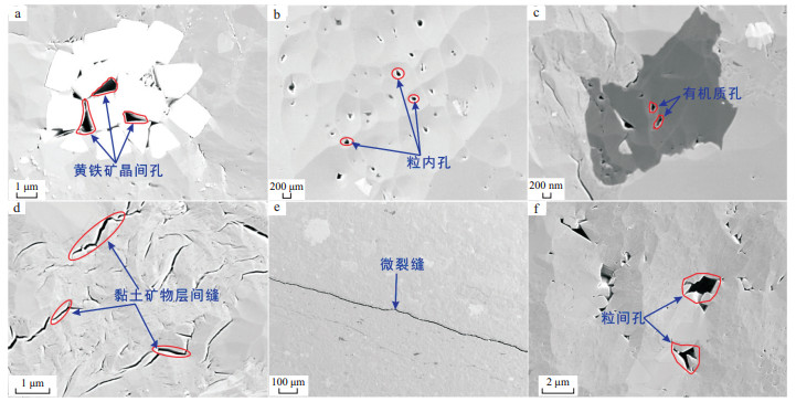
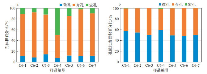
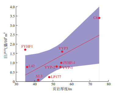
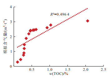
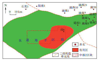
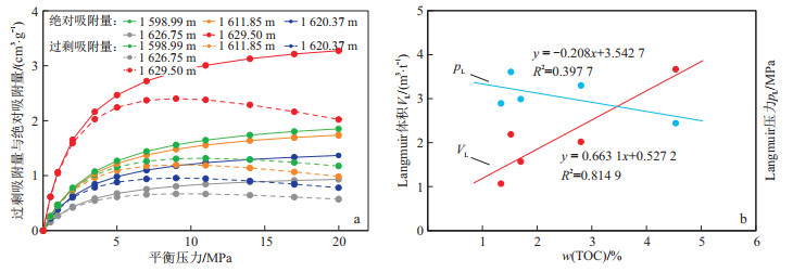
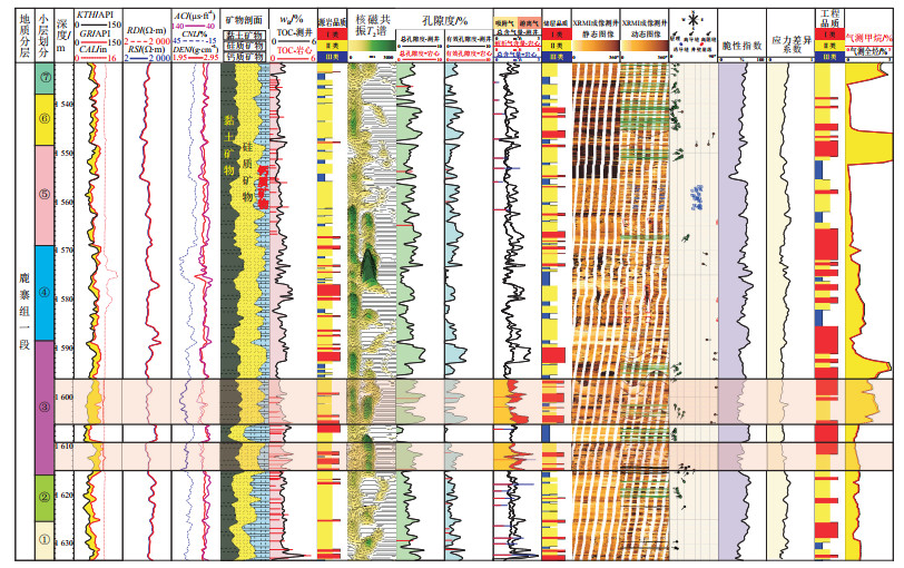
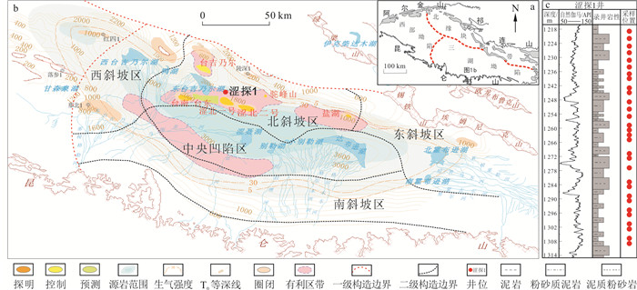
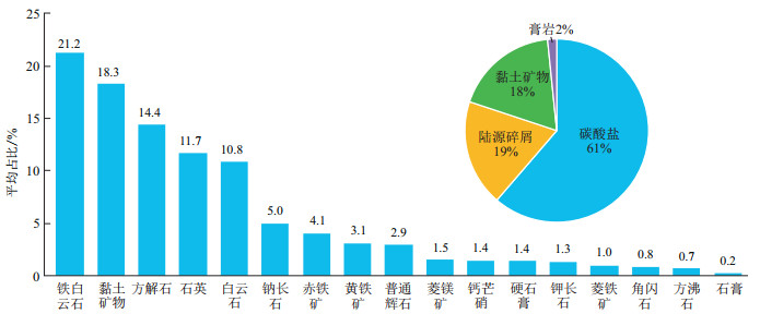
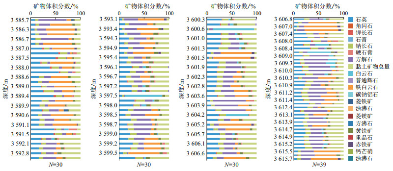
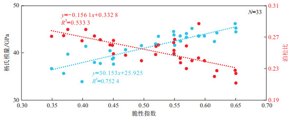
Results

The results show that: (1) The organic matter of the Lower Wuerhe Formation shale is dominated by Ⅱ2 and Ⅲ types and shows an average TOC content of 1.58%. The average vitrinite reflectance (Ro) of organic matter is 1.46%, which indicates the mature stage. The average thickness of the source rock is 75 m. Summarily, the source rock is good and has a high gas potential. The basin simulation results show an average shale gas content of 1.89 m3/t in the Lower Wuerhe Formation. (2) The pores and microfractures in shale reservoirs are highly developed, and gas is primarily adsorbed in micropores and mesopores. The average porosity and permeability are 6.10% and 0.27×10⁻³ μm2 respectively, which are favourable for shale gas accumulation. (3) The shale has a high clay mineral content, with an average of 29.6%, providing a significant specific surface area and enhancing the gas adsorption capacity of the shale. Additionally, the average brittle mineral content is 50.9%, indicating good frackability. (4) Moreover, the shale reservoir exhibits a relatively large pressure coefficient of 1.58, indicating the favourable conservation conditions. The analysis of the regional tectonic-sedimentary environment and geochemical parameters indicates that the main factors controlling shale gas accumulation in the Lower Wuerhe Formation of the Dongdaohaizi Sag are geochemical parameters and preservation conditions. The key factors influencing shale gas accumulation include the high thermal evolution maturity of organic matter, large shale thickness, high TOC content, and good preservation conditions. These conditions suggest that the favourable area for shale gas exploration and development in the Dongdaohaizi Sag is located in the northeastern slope area of the sag's abdomen.

Conclusion

The results of this research reveal the enrichment conditions and main controlling factors of shale gas in the Lower Wuerhe Formation in the Dongdaohaizi Sag, which has reference value for deep oil and gas exploration in the abdominal area of the Junggar Basin.

A logging evaluation method for geological engineering "double sweet spot" for shallow marine shale gas: A case study of the Luzhai Formation in the northern Guizhong Depression
ZHONG Ming, HUANG Yuyue, QIN Yinglun, CHEN Kangjun, WANG Guiwen, ZHUO Seqiang, BI Shaocheng, LU Wenshi, KANG Haijing, DANG Wenle, LAI Jin
2024, 43(4): 113-127. doi: 10.19509/j.cnki.dzkq.tb20230615
Abstract:
Objective

The marine organic-rich shale of the Luzhai Formation of the northern Guizhong Depression is an important replacement field for shale gas exploration in the Dian-Qian-Gui Basin. At present, great breakthroughs have been made in the initial stage of exploration. So it is very important to evaluate the geological-engineering integration.

Methods

In this study, petrophysical data (e.g., core, thin section and scanning electron microscopy data) and logging data (e.g., conventional, imaging, nuclear magnetic resonance and array acoustic) are used to study the logging characteristics of geological and engineering "sweet spots" on the basis of core calibration logs and fine delineation of small layers, respectively. By superimposing the hydrocarbon source rock quality, reservoir quality and engineering quality, the coupling and optimization of geological and engineering "double sweet spots" are finally completed.

Results

The results show that the lithology of the shale in the first member of the Luzhai Formation is dominated by three types: siliceous shale, mixed shale and gray shale. The organic matter abundance and pore permeability are low, and the TOC content is between 1% and 2%. The biogenic silica content is low, and the source of silica is mainly the land source of debris supply. Shale gas is mainly stored in the pore spaces and microfractures associated with clay minerals, and adsorbed gas is the main source, while the free gas content accounts for a small proportion. The brittleness index ranges from 20% to 80% and is basically greater than 40%. The stress coefficient of variation ranges from 0.26 to 0.50, and the direction of the present maximum horizontal in situ stress is NNE-SSW.

Conclusion

The shale "sweet spot" section at the bottom of the third small layer was selected as the target window of the horizontal well, and the results of horizontal section drilling and gas measurement showed good results. The research results can provide theoretical guidance and methodological support for the evaluation of "sweet spot" logging and the selection of horizontal well target windows for shale gas wells.

Evaluation of the characteristics of biogenic gas production based on the CDOM spectral characteristics of shales
ZHENG Xiaoxuan, TIAN Jixian, TIAN Cong, JIANG Zhengwen, YANG Lei, HE Qiufang, XUE Honglei
2024, 43(4): 128-140. doi: 10.19509/j.cnki.dzkq.tb20230652
Abstract:
Objective

The composition and degradability of dissolved organic matter (DOM) play a critical role in evaluating biogenic gas production during shale gas exploration. A simple and effective method needs to be developed to assess the composition, functional groups and microbial activity of DOM, which will provide crucial valuable information concerning the gas production mechanism in the field of biogenic shale gas.

Methods

Shale samples were collected from depths of 1 219 m to 1 309 m from the ST1 exploration well located at the edge of the Sebei No.1 gas field in the Qaidam Basin. According to the 3D fluorescence of the extraction and emission matrix (EEM) and the UV visible absorption spectrum characteristics of chromophoric dissolved organic matter (CDOM), the composition, functional group and degradation characteristics of CDOM were analysed to determine the distribution of methanol formation substrates.

Results

The DOM in the samples mainly consisted of the small molecular tryptophan-like fluorescent components C1 and C3, which are readily degradable by biotic processes and account for 70.54% of the total fluorescence intensity. The fluorescence components, fluorescence parameters (HIX, BIX), and absorbance ratios (E253/E203, SUVA254) confirmed that the core layers at depths of 1 219-1 222 m and 1 285-1 301 m were potential effective gas-generating formations. These layers contain low amounts of humified organic matter, weak aromaticity and high amounts of methanol functional groups. The active gas-generating formations are generally consistent with those in previous reports.

Conclusion

The results indicated that the CDOM spectrum is a valuable method for exploring the methanol formation substrate distribution and microbial activity. The CDOM-EEM method has the potential to serve as an effective indicator of the methanol formation characteristics of DOM in mud shale and provides an effective and essential way to assess geochemical-based gas production capacity in hydrocarbon source rocks.

Characteristics and exploration potential of shale oil reservoir in the Upper Member of the Xiaganchaigou Formation in the Ganchaigou area, western Qaidam Basin
HUANG Jianhong, JIANG Wei, TAN Xianfeng, WU Songtao, CAI Xinyong, WU Kunyu, ZHANG Qinghui
2024, 43(4): 141-153. doi: 10.19509/j.cnki.dzkq.tb20230493
Abstract:
Objective

Well C902, located in the Ganchaigou area of the western Qaidam Basin, achieved a breakthrough in shale oil exploration as indicated by the high-production oil flow in the Ⅳ-Ⅵ layers of the Upper Member of the Palaeogene Xiaganchaigou Formation. However, ambiguities in evaluation criteria and resource potential limit the efficiency of shale oil development in the Upper Member of the Xiaganchaigou Formation in the Ganchaigou area.

Methods

Thus, the exploration potential of shale oil in the Ⅳ-Ⅵ layers of the Upper Member of the Xiaganchaigou Formation in the Ganchaigou area was comprehensively evaluated by comparing the lithology, physical properties, pore structure, and organic geochemistry between Well C902 and other wells.

Results

The complicated lithofacies of laminar/lamellar dolostone, laminar/lamellar limestone, laminar clay shale, and lamellar mudstone suggest the mixed carbonate and siliciclastic deposition of the Ⅳ-Ⅵ layers. The high brittleness index implies the good fracability of the Ⅳ-Ⅵ layers. The intergranular pores and laminar fractures, with a total proportion of 85% in the pore system, were dominant in the Ⅳ-Ⅵ layers that can be roughly classified as low-porosity and ultralow-permeability reservoirs. The organic matter, dominated by type Ⅰ-Ⅱ1, shows an average TOC content of more than 0.9% in the Ⅳ-Ⅵ layers. Both chloroform asphalt "A" and S1+S2 indicate a high hydrocarbon generation capacity.

Conclusion

Summarily, the widely deposited the Ⅳ-Ⅵ layers of the Upper Member of the Xiaganchaigou Formation have the characteristic of source-reservoir integration and show not only good quality of source rock but also strong fracability of the shale oil reservoir. The excellent source-reservoir-caprock assemblage is also widely developed, which ensures good sealing ability and favors improving oil and gas recovery after fracturing. This study can theoretically improve the development efficiency of shale oil in the Ganchaigou area.

Sequence stratigraphic architectures and sand-body distribution models of the Pinghu Formation in the Pingbei slope belt of the Xihu Depression
XU Donghao, QIN Lanzhi, LI Junjie, CAI Kun, XIE Jingjing
2024, 43(4): 154-166. doi: 10.19509/j.cnki.dzkq.tb20240027
Abstract:
Objective

The Pingbei slope belt is one of the key zones for the exploration of lithologic reservoirs in the Xihu Depression. However, the exploration process was inhibited by issues of small thickness and significant lateral variation of sand-bodies. Therefore, research on the tectonic-sedimentary response, including the stratigraphic development patterns, deposition center evolution, and sand-body distribution mechanisms in different tectonic units, is urgently needed.

Methods

Integrating the newly obtained well drilling, well logging, and high-resolution 3D seismic data, a high-precision sequence stratigraphic framework was established and the third-order sequences and systems tracts were analysed in the Pinghu Formation of the Pingbei slope belt.

Results

Based on differences in palaeogeomorphology and fault systems, the tectonic-sedimentary units of the Pingbei slope zone were classified. Differences in fault styles, stratigraphic contact relationships, and sedimentary filling patterns under different sequence stratigraphic architectures were analysed in various tectonic units. Additionally, the controlling factors and models of sand-body distribution in various sequence stratigraphic architectures were discussed.

Conclusion

This study revealed that the Pingbei slope zone can be divided into four types of sequence stratigraphic architectures: steep fault slope, opposite fault step, reversal step fault, and forward step fault. The sequence stratigraphic architectures that were controlled by factors of sediment supply, fault activity, palaeogeomorphic, and base-level cycles generated four sand-body distribution models. Research on the differences in sequence configurations and sand-body distribution models in different tectonic units is important for promoting the exploration of lithological reservoirs in the Pingbei slope belt of the Xihu Depression.

Radiolarian assemblage from the Upper Permian Wujiaping Formation in the eastern Sichuan Basin and its hydrocarbon source significance
YI Yuhao, BAO Hanyong, ZHU Hongtao, LU Yaqiu, MENG Zhiyong, LI Kai, CHEN Fayao
2024, 43(4): 167-180. doi: 10.19509/j.cnki.dzkq.tb20230721
Abstract:
Objective

The upper Permian Wujiaping Formation in the Hongxing area of eastern Sichuan Province has good shale gas accumulation conditions and is also an important successor for Permian shale gas exploration in the Sichuan Basin. However, the formation mechanism of these siliceous-argillaceous source rocks is still unclear. Apart from their petromineralogical characteristics, geochemical composition and macrofossil assemblage (represented by radiolarian) are also important for identifying the genesis of this siliceous-argillaceous source rock.

Methods

Radiolarian is a significant planktonic component of the Phanerozoic marine ecosystem. Various radiolarian assemblages indicate different sedimentary environments, and their abundance is a good indicator of palaeoproductivity. In this study, radiolarians were separated by the acid-etching method to identify different morphological characteristics, and the correlation between radiolarian abundance and total organic carbon (TOC) content was also analysed through thin-section observation.

Results

A large number of radiolarians were found in the Wujiaping Formation in the Well HY3 in the Hongxing area of eastern Sichuan Province. These fossils were identified as Spumellaria and Entactinaria, belonging to a typical shallow-water radiolarian assemblage, namely, the Se assemblage. In the Second Member of the Wujiaping Formation, the radiolarian abundance exhibited a relatively positive correlation with the TOC content.

Conclusion

Based on the radiolarian assemblage characteristics, sedimentary sequence and palaeogeographic background of the Wujiaping Formation, it is inferred that these source rocks from the Second Member of the Wujiaping Formation formed in a shallow-water environment less than 60 m deep. The accumulation of organic matter in the Second Member of the Wujiaping Formation was probably affected by primary productivity, redox conditions, terrigenous debris input and upwelling, among which high palaeoproductivity was one of the main controlling factors.

Sedimentary characteristics and favourable area selection of tight sandstone gas reservoirs in the Sanjianfang Formation of the Shengbei Depression, Tuha Basin
SHENG Shuangzhan, PAN Haifeng, SHI Xiang, FENG Liping
2024, 43(4): 181-190. doi: 10.19509/j.cnki.dzkq.tb20230182
Abstract:
Objective

The Shengbei Depression is the largest petroliferous depression of the Tuha Basin. With the strong demand for the exploration and development of tight sandstone gas in the Middle Jurassic Sanjianfang Formation, it is urgent to study the sedimentary characteristics and predict favourable exploration zones of the Sanjianfang Formation.

Methods

Using core, well logging, and seismic data, the high-resolution sequences and sedimentary characteristics of the tight sandstone gas reservoir in the Sanjianfang Formation of the Shengbei Depression were studied. A lacustrine delta system was identified, and favourable exploration zones of tight gas reservoirs were predicted.

Results

Three long-term sequences (L1, L2, L3) and five medium-term sequences (M1, M2, M3, M4, M5) were developed in the Sanjianfang Formation in the Shengbei Depression; particularly, these medium-term sequences can be regionally identified. The deposition of the M1 to M3 sequences involved a braided river delta in the lake, but the deposition of the M4-M5 sequences involved a meandering river delta in the lake. The favourable tight gas reservoirs of the Sanjianfang Formation in the Shengbei Depression were mainly developed in subfacies of the delta front. On the plane, the Shengbei 5 and Shengshen 3 well areas of the M2 sequence, the Shengbei 5 and Shengbei 6 well areas of the M3 sequence, and the Shengbei 5, Shengbei 6, and Shengtan 1 well areas of the M5 sequence are favorable exploration areas. The favorable reservoir rarely appears in the M4 sequence.

Conclusion

This research can promote the exploration of tight gas reservoirs in the Sanjianfang Formation of the Shengbei Depression in the Tuha Basin.

Principle of Earth materials: A historical perspective of thermodynamics of the Earth
WANG Chao, QU Miao, YU Huiyang
2024, 43(4): 191-204. doi: 10.19509/j.cnki.dzkq.tb20230210
Abstract:
<p>Earth is a combination of material and energy. The evolution of Earth and planets is a history of the transfer of matter and energy. Materials science is codified into physics and chemistry, while mathematics is the language that describes the law of nature, which belongs to the field of thermodynamics.</p></sec><sec><title>Significance

Thus, thermodynamics, consisting of physics, chemistry and mathematics, can unravel the principles of earth materials. Since the middle of the 19th century, Kelvin used thermodynamic theory to calculate the age of the Earth, and thermodynamics has been applied in the field of earth science for more than 100 years, which has provided a vital theoretical framework for understanding the planet's formation and evolution. Its application revolutionized the development of earth science.

Progress

In the past 20 years, with the development of physics, chemistry and computer science, the application and development of classical thermodynamics and nonequilibrium thermodynamics in earth matter science have further improved and become the fundamental principal system of earth material research. The thermodynamics of earth have been studied to determine the structure, dynamics and evolution of earth by studying the formation and evolution of earth materials. Thermodynamics links geophysics, geochemistry and geology. However, new thermodynamic models, databases, and methods for teaching and learning about thermodynamics in earth science need to be developed.

Conclusions and Prospects

It is foreseeable that understanding the earth and its evolution from the perspective of thermodynamics will be a permanent issue. Thermodynamics will exert its power in unknown fields such as planetary science, earth's internal evolution as well as earth systems science, driving people to make new observations and theories about nature.

Pore characteristics and seepage simulation of sandstone-type uranium ore in the 512 deposit, Xinjiang
LIU Yaling, LI Guangrong, ZHOU Yipeng, SUN Zhanxue, ZHAO Kai, LIU Jinhui, XU Lingling
2024, 43(4): 205-218. doi: 10.19509/j.cnki.dzkq.tb20230134
Abstract:
Objective

In situ leaching is a uranium extraction process in which a solution reacts with uranium-bearing minerals in a saturated aquifer and then uranium in the flowing solution is extracted through exchange. To understand the internal structure and seepage path of the 512 deposits,

Methods

representative wallrock and ore cores of the deposit were selected for CT scanning, and the pore throat parameters were obtained via image noise reduction filtering, image segmentation to extract pores, and the construction of pore network models. The changes in the absolute permeability, tortuosity and seepage velocity are simulated with Avizo software.

Results

The results showed that the porosity of the wallrock was 15.42%, the connected porosity was 9.61%, the ore porosity was 15.18%, the connected porosity was 13.82%, and the water permeability was better than that of the wallrock. The high-density materials in the wallrock are metal minerals, accounting for approximately 0.54%, and most of the high-density minerals in the ore are secondary uranium minerals, accounting for 1.06%. It can be fully in contact with the solution during the leaching process.

Conclusion

There is strong heterogeneity inside the pores, which causes the flow rate to gradually decrease in the flow path. The number of large pores connecting the wallrock and ore is greater than that of small pores, indicating that large pores are the main factors determining the degree of pore development. According to the velocity streamlines, although there is a blockage area in the wallrock and ore, the circulation area is dominant.

Newly identified iron oxide-apatite deposit in Carboniferous marine volcanic rocks in the Beishan area and its implications for regional metallogeny: A case study of the Biyushan iron deposit, Inner Mongolia
HU Hao, YIN Yong, XU Lei
2024, 43(4): 219-223. doi: 10.19509/j.cnki.dzkq.tb20230559
Abstract:
Objective

Numerous iron deposits hosted in Carboniferous marine volcanic rocks occurred in the Beishan Orogenic Belt, Eastern Tianshan.The Biyushan iron deposit, located at the northwestern margin of Inner Mongolia, is a typical iron deposit hosted in Carboniferous marine volcanic rocks.

Methods

In this study, we utilized field observation, microscope imaging, and scanning electron microscopy to charaterize the mineral assemblages of iron ores and microtextures of magnetite and apatite, in order to decipher the genesis of iron ores.

Results

Our preliminary work has revealed that iron ores in the Biyushan deposit commonly have a mineral assemblage of magnetite-apatite, with apatite having abundant monazite inclusions due to the dissolution-reprecipitation processes.In addition, magnetite grains commonly have high Ti contents with ilmenite exsolution.Thus, the mineral assemblage of iron ores and mineralogical features of apatite and magnetite are similar to these of typical Kiruna-type deposits.

Conclusion

Based on our preliminary analysis of geological characteristics, we suggest that the Biyushan iron deposit in Inner Mongolia is likely a Kiruna-type iron deposit hosted in submarine volcanic rocks that has not yet been documented.Therefore, these findings can guide future exploration of iron oxide-apatite deposits in this region.

Recognition and application of geological entities related to ore-forming conditions in the Kaiyang phosphate mine based on the XLNET model
PENG Bin, TIAN Yiping, ZENG Bin, WU Xuechao, WU Wenming
2024, 43(4): 224-234. doi: 10.19509/j.cnki.dzkq.tb20230543
Abstract:
Objective

With increasing difficulty in phosphate ore prospecting, there are an increasing number of geological exploration reports. The manual recognition of geological information related to phosphate rock mineralization in massive documents is time-consuming and inefficient. It cannot meet the needs of knowledge sharing, dissemination and intelligent management of geological reports.

Methods

To quickly obtain the ore-forming geological knowledge hidden in the phosphate ore reports, this work intends to establish an automatic recognition method for ore-forming geological entities based on the extreme learning machine network(XLNET) model. First, BIO labelling of entities was carried out to establish a geological entity dictionary, and XLNET was used as the underlying preprocessing model to learn the bidirectional semantics of sentences. Then, the BILSTM-Attention-CRF(bidirectional long short term memory(BILSTM)-self attention layer(Attention)-conditional random field(CRF)) model was used to realize intelligent classification of multiple text labels. Finally, the ore-forming conditions and ore-forming model of phosphate ore in the reports were roughly predicted by locating the distribution position of phosphate ore entities in the report.

Results

Comparing this model with the other three models, these results show that the accuracy rate, recall rate and F1 value of this model are close to 90%, which are 2%, 5% and 6% higher than those of the previous three models, respectively.

Conclusion

This study provides a more efficient method for automatic geological entity recognition for geological researchers in the Kaiyang phosphate mine.

Energy dissipation during disintegration of red-bed soft rock in the Shengzhou-Xinchang area of Zhejiang Province, China
HUANG Shenggen, HE Mingjian
2024, 43(4): 235-243. doi: 10.19509/j.cnki.dzkq.tb20230174
Abstract:
Objective

This study focused on the surface energy characteristics of red-bed soft rocks during disintegration in the Shengzhou-Xinchang area of Zhejiang Province.

Methods

Based on the principle of energy dissipation, this study analyzed the conversion, transfer, and dissipation of energy during the process of disintegration under dry-wet cycles for three groups of red-bed soft rocks, considering different compositions in the study area. This study aimed to explore the law of energy absorption and transformation into surface energy during the process of red-bed soft rock disintegration.

Results

The results show that the surface energy accumulation of the red-bed soft rock in the study area undergoes three stages with an increasing number of dry-wet cycles: a slow growth stage, a rapid growth stage, and a stable stage. The results also indicate that the higher the content of clay minerals in the red-bed soft rock is, the more surface energy it generates, and the poorer its resistance to disintegration.

Conclusion

The energy dissipation model proposed in this study provides a reference for the governance of various failure problems of the red-bed soft rock in the Shengzhou-Xinchang area of Zhejiang Province.

Fractal characteristics of displacement and cracks in the Baishuihe landslide in the Three Gorges Reservoir Area
XIE Yuanhua, ZHANG Guowei, CAO Zongwei, MIAO Fasheng
2024, 43(4): 244-251. doi: 10.19509/j.cnki.dzkq.tb20230166
Abstract:
Objective

Surface displacement and crack development are the most intuitive manifestations of landslide deformation and evolution. Therefore, revealing the characteristics and evolution stages of landslide deformation and failure through displacement monitoring and surface crack survey is highly practical.

Methods

In this study, the Baishuihe landslide in the Three Gorges Reservoir Area is selected as the research case, and monitoring data from 2003-2016 for this landslide are systematically collected and analyzed, taking monitoring points ZG93 and ZG118 as example. First, the fractal parameter Hurst index R/S analysis is carried out for the displacement data. Second, the multiple fractal dimensions of the displacement of the two monitoring points are calculated every year. Finally, the theory of stage matching of landslide cracks is introduced, and the crack fractal dimension of the Baishuihe landslide is determinated.

Results

The results show that there is a certain positive correlation between the landslide displacement sequences, and the fractal dimension H index of the two monitoring points is greater than 0.5. The evolution process of the Baishuihe landslide can be divided into a steady deformation state (from June 2003 to June 2007), an accelerated deformation state (from June 2007 to December 2009), and a steady deformation state (from December 2009 to December 2015). According to the matching law of crack stages, the development of the landslide is the initial deformation stage.

Conclusion

The research results have a certain guiding significance for revealing the evolutionary state of reservoir landslides.

A prediction model of the joint roughness coefficient based on Gaussian process regression
ZHENG Kexin, WU Yiping, LI Jiang, MIAO Fasheng, KE Chao
2024, 43(4): 252-261. doi: 10.19509/j.cnki.dzkq.tb20230113
Abstract:
Objective

Estimating the joint roughness coefficient (JRC) is essential for evaluating the mechanical properties of a rock mass. Due to the limitation of a single statistical parameter for characterizing morphology, JRC values estimation by a single statistical parameter may produce a sufficiently unreliable result.

Methods

To address the existing challenges in determining JRC values, a model based on Gaussian process regression (GPR) combined with principal component analysis (PCA) was proposed for the quantitative evaluation of JRC. Notably, eight parameters were selected as indicators for the comprehensive expression of the rock joint roughness. To analyse the model's performance, a publicly available dataset of 112 rock joint profiles was used as an example, of which 95 were chosen as training samples and 17 were chosen as validation samples. The reliability of the model was verified by comparing the predicted results with the measured JRC values.

Results

The results show that the derived GPR model demonstrates promising performance (R2=0.972, MSE =0.517) for estimation of JRC values, indicating the high applicability of the model in constructing implicit relationships between multiple statistical parameters and JRC values even under small sample conditions.

Conclusion

In general, the GPR model may provide a new way of estimating JRC values with artificial intelligence.

Determination method of fracture aperture based on three-dimensional fracture network simulation and water injection tests
CHENG Jinbo, XIA Lu, YU Qingchun
2024, 43(4): 262-272. doi: 10.19509/j.cnki.dzkq.tb20230128
Abstract:
Objective

The aperture of fractures (hydraulic equivalent aperture of fractures) of rock fractures is one of the key mechanical parameters of rocks.It has significant indicative significance in water conservancy projects, geological surveys and so on.At present, large-scale test methods such as cross-hole tests are often used to obtain the fracture apertures of deep rock masses in the field, but this method is rarely used many times in projects, and it is difficult to analyse the spatial variation in the aperture of fractures. This spatial variation is precisely what we need to focus on and discuss because it affects the accurate definition and application of the hydraulic equivalent fracture aperture in engineering applications.

Methods

In this paper, taking the surrounding rock of an underground power station cavern on the right bank of the Three Gorges Dam as an example, a new inversion method for determining the hydraulic equivalent aperture of fractures is proposed by using conventional single-hole water injection test data and three-dimensional fracture network simulation. The statistical data obtained from the measured fracture cataloguing data are used to carry out random simulation of fracture characteristics, and a three-dimensional discrete fracture network seepage model connected with water injection test boreholes is constructed to fit the relationship between the single-hole steady-state flow rate and injection. The hydraulic equivalent apertures of fractures at different depths of rocks are inverted.

Results

The results show that the hydraulic equivalent aperture of fractures in the research area is generally 0.07-0.30 mm, which confirms to the statistical characteristics of the log-normal distribution. Most of the inverted hydraulic equivalent apertures of fractures in boreholes decrease exponentially with burial depth, while a few boreholes show strong randomness of the hydraulic equivalent aperture of fractures and no obvious change with burial depth.

Conclusion

Compared to those of traditional methods, the inversion results of this approach are significantly different and require further verification.

Control of tectonic evolution on karstification and karst collapse in the Lianzhou Basin, northwestern Guangdong Province
FAN Yu, HUANG Kun, DUAN Huiyu, LIN Yuhang, LUO Mingming, WAN Junwei, WEN Hanhui, QU Jincai, ZHANG Longxuan
2024, 43(4): 273-290. doi: 10.19509/j.cnki.dzkq.tb20230120
Abstract:
Objective

There is still a lack of systematic understanding of the evolution process of the Lianzhou Basin since the Mesozoic and its response to karstic development.

Methods

Based on the comprehensive analysis of the latest field geological investigations, hydrogeological drilling, dissolution experiments, and three-dimensional geological modelling, the tectonic evolution stages of the basin can be divided, and the karstification of each stage can be discussed by considering the existing geological data.

Results

Before the Cretaceous, carbonate rocks with strong dissolution were successively deposited under the rise or fall movement of the crust, which laid a material foundation for karstic development. The Indosinian movement caused vertically multilayered strata to form an E-W-trending structure, and the Yanshanian movement made the straddle-oblique superimposed a NE-SW-trending structure. They controlled the geological structures, spatial distribution, and dissolution behaviors of carbonate strata. And the distribution of mountains and river system were established. However, karst generally does not develop. An intracontinental and intermountain faulted confluence lake basin formed from the Cretaceous to the Palaeogene, the slow crustal uplift strengthened the karstification around the basin, and it currently retains the early karst platform. Later, they were buried-filled-consolidated by alluvial deposits; therefore, karst basically stopped developing, generating a thick-covered red strata basin. Since the Neogene, the rapid uplift of the crust has led to the continuous elevation of mountains around the basin, deepening of rivers, and strong development of karst, shaping multilevel karst platforms. When part of the Cretaceous red strata in the basin are denuded or cut through, karstification is reactivated. After many changes and penetrations of water systems, the graben basin formed, with karst strata covered by Quaternary sediments, Tectonic evolution controls karstic development, karstification influences the internal structure of the basin, and soil structure causes karst ground collapse.

Conclusion

This study can provide a scientific basis and guidance for understanding karst collapse conditions in covered karst areas.

A comparative study of Kriging and deep learning methods for shallow groundwater level estimation: A case study of the Shenzhen-Shanwei Special Cooperation Zone
WANG Quanjuan, SUN Jingfeng, YANG Yingjie, ZHANG Jiangwei, WANG Guoliang, MA Enze, LIU Jin, ZHAO Xin
2024, 43(4): 291-301. doi: 10.19509/j.cnki.dzkq.tb20230192
Abstract:
Objective

Knowledge of the regional groundwater level is an important foundation for groundwater resource evaluation and protection. Due to the limited amount of groundwater level data available at the regional scale, Kriging interpolation and deep learning methods are gradually being used for regional groundwater level prediction, but their applicability and robustness lack comparative analysis.

Methods

In this paper, spatial interpolation of groundwater levels in the Shenzhen-Shanwei Special Cooperation Zone was carried out using ordinary Kriging, coKriging and deep learning methods to explore the potential of these three methods for practical application to regional groundwater level prediction. To investigate the effect of the training set sample size on the prediction effect of the three methods, 239 monitoring wells were divided into two groups of 76 and 163 wells for the training of the three models.

Results

The results showed that the RMSEs were 6.09, 4.04, and 7.11 when the training data of 76 wells were used to fit the validation set, and the Kriging method, which accounts for surface elevation information, was significantly better than the ordinary Kriging method and the deep learning method. In addition, the predicted water level distribution improved when a larger number of samples was used to predict the water level in the region. However, the spatial distribution characteristics still differed significantly.

Conclusion

The results show that when the observation data are sparse, the prediction effect of coKriging with elevation information is significantly greater than that of ordinary Kriging and deep learning methods, while the RMSEs obtained by the three methods are similar when the amount of observation data increases to a certain amount.

Prediction of ultradeep pore water inflow in giant thick heterogeneous aquifers
CHEN Di, YAN Haitao, QIAO Xiangyu, WANG Quanrong
2024, 43(4): 302-310. doi: 10.19509/j.cnki.dzkq.tb20230122
Abstract:
Objective

The analytical solution model is computationally efficient and widely used to estimate aquifer surges. Analytical solution models are computationally efficient but involving many assumptions, such as that the aquifer is homogeneous, the amount of water pumped is constant, while the head loss in the well is ignored; these models are often referred to as homogeneous models. In fact, these assumptions are often not met, resulting in nonnegligible errors in the results, especially for heterogeneous giant thick aquifers.Meanwhile, the homogeneous model cannot estimate the permeability coefficient and water inflow of the broken zone, which is not conducive to solve the water problem during tunnel construction.

Methods

In this study, two pumping tests were carried out on the Shengli Tunnel Project in Tianshan Mountain, Xinjiang. A geological model was established based on comprehensive logging data and borehole data; a heterogeneous numerical simulation method was used to quantitatively investigate the amount of groundwater inflow in bore holes. The parameters in the rate determination model of the observation data of the first pumping test were used, and the rationality of the model and the postrate parameters were verified by the observation data of the second pumping test.

Results

The permeability coefficients of the fracture zone, intact granite and relatively intact granite were inverted and were 0.000 93 m/d, 0.000 5 m/d and 0.000 3 m/d, respectively. The total water inflow and the water inflow of the fracture zone were predicted to be 14.80 m3/h and 10.46 m3/h, respectively, of which the water inflow of the broken zone accounted for 70.676% of the total water consumption.

Conclusion

Field observations revealed head loss in aan ultradeepbore hole during pumping test. The heterogeneous numerical simulation model can explain the ultradeep hole pumping test data better than the homogeneous model, and the total water inflow calculated by the homogeneous model is 18.67 m3/h, which overestimates the water inflow. During tunnel construction, the hydrodynamic parameters and water inflow obtained by the heterogeneous model are more reliable.