Current Issue

2024 Vol. 43, No. 3

Display Method:
Optimization of pattern of well in hot dry rock fractured reservoirs through numerical simulation
ZHANG Ligang, HU Zhinan, FAN Sen, LUO Xiaolei, DING Hejia, MA Yuanyuan, LI Qinglong, SONG Yongyang
2024, 43(3): 1-11. doi: 10.19509/j.cnki.dzkq.tb20230661
Abstract:
Objective

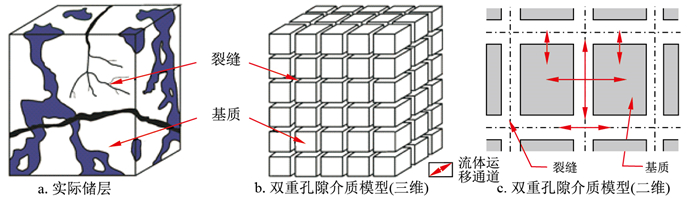
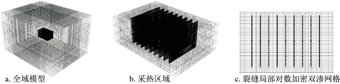
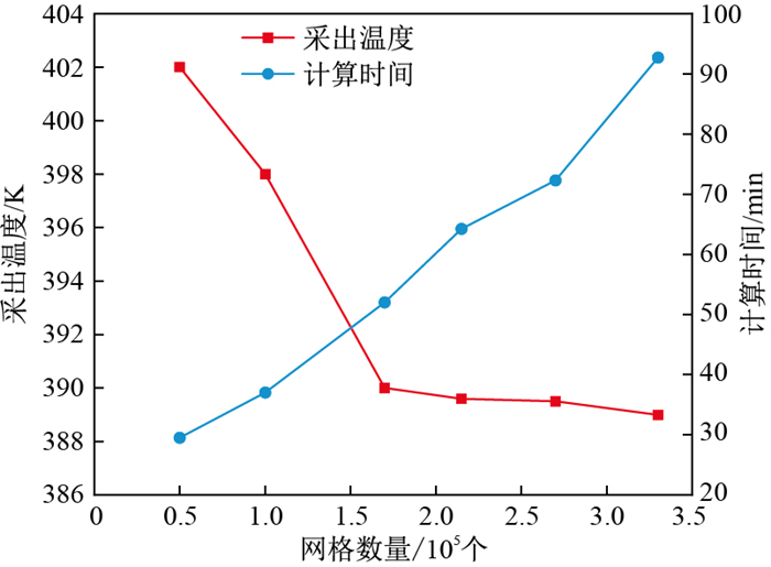
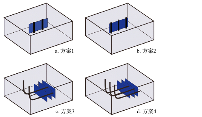
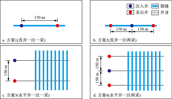
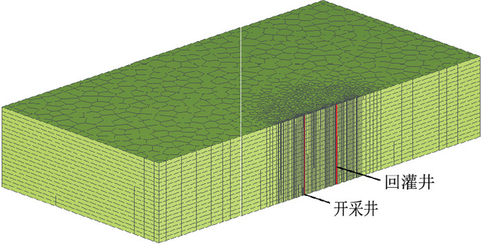
An enhanced geothermal system (EGS) is a crucial means of extracting thermal energy from hot dry rock reservoirs, and the pattern of well plays a key role in influencing heat extraction efficiency. Currently, there is limited research on pattern of well considering fractured reservoir exploitation models.

Methods

This paper establishes a numerical model for heat extraction from hot dry rock fractured reservoirs and analyses the impact of four different patterns of wells on EGS heat extraction performance through a comparative analysis of the temperature decrease of the bedrock, heat extraction rate, production temperature, and heat extraction power.

Results

The results indicate that, compared to vertical wells, horizontal wells have a larger area for fluid heat exchange, allowing for more efficient heat development between fractures. After 30 years of production, considering the case of hydraulic fracturing fracture connectivity, the one injection and two production schemes of horizontal wells exhibit the highest heat extraction efficiency. In the vertical well direction, the temperature influence range is approximately 690 m, with an average temperature decrease of 38.09 K in the bedrock, a heat extraction rate of 24.42%, and a heat extraction power of 3.5 MW.

Conclusion

The research results provide a theoretical reference for enhancing the heat production of geothermal systems and achieving efficient and sustainable development of hot dry rock resources.

Performance analysis of thermal energy storage for space heating and CO2 sequestration in depleted oil and gas reservoirs
WANG Yanxin
2024, 43(3): 12-21. doi: 10.19509/j.cnki.dzkq.tb20230628
Abstract:
Objective

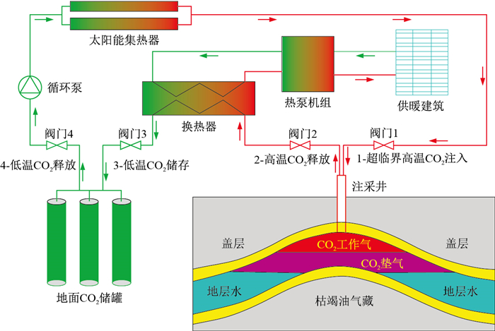
Thermal energy storage and CO2 sequestration in depleted oil and gas reservoirs can not only solve the problem of seasonal solar thermal energy storage but also increase the share of renewable energy space heating and enhance the economy of CO2 geological sequestration.

Methods

A novel scheme of thermal energy storage for space heating and CO2 sequestration in depleted oil and gas reservoirs is proposed by storing solar thermal energy in depleted oil and gas reservoirs in summer and extracting thermal energy for space heating in winter using CO2 as the working medium. A mathematical model of the energy storage and release process is established, and the thermal performance and CO2 sequestration performance of energy storage system in depleted oil and gas reservoirs are analysed.

Results

The results show that (1) the novel scheme has excellent thermal performance, with a single-well thermal extraction power of 4 808.95 kW, a thermal energy storage capacity of 49 859.21 GJ per heating season and an energy storage density of 28 984.23 kJ/m3. (2) The novel scheme has an energy recovery efficiency of 95.84% and a thermal recovery efficiency of 83.66% due to the strong sensitivity of the CO2 density to temperature. (3) The solubility trapping of CO2 in formation water is accelerated by the energy storage process. The periodic injection and extraction of CO2 during the process of energy storage and release causes the repeated expansion and contraction of the gas-water interface, which increases the gas-water contact area and improves the driving force of mass transfer, thus leading to an increase in CO2 dissolution in the formation water. Compared with the CO2 sequestration model alone, the mass ratio of CO2 dissolution in formation water for the energy storage model increases from 0.26% to 2.22%.

Conclusion

Overall, the novel scheme has excellent thermal performance. It accelerates CO2 geological sequestration and is a high-value scheme for depleted reservoir utilization and renewable energy space heating. It has great potential for wide application.

Geothermal chemical characteristics and genetic model of the Qingshankou Formation in the Daqingzijing area, southern Songliao Basin
DU Xianli, WANG Hongbo, ZHAO Rongsheng, JI Hui, ZHU Huanlai, DAI Dengliang, WANG Ying, LI Yingjiu, XIAO Hongping
2024, 43(3): 22-35. doi: 10.19509/j.cnki.dzkq.tb20230605
Abstract:
Objective

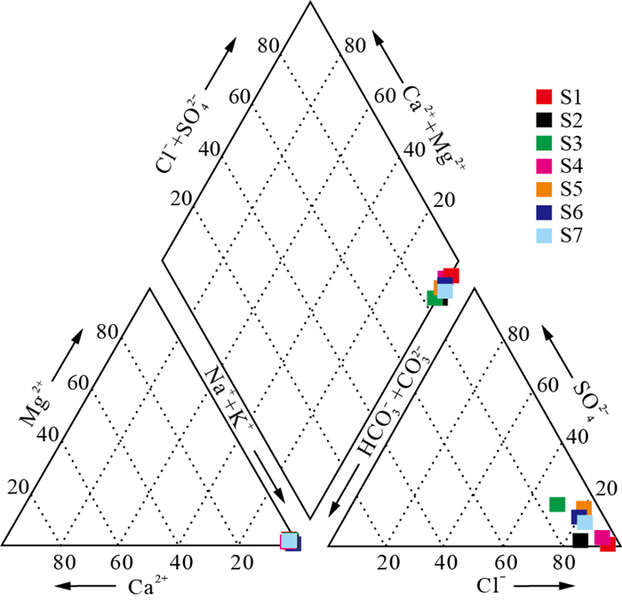
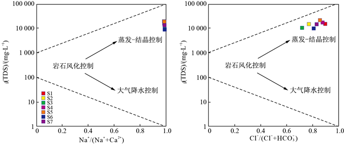
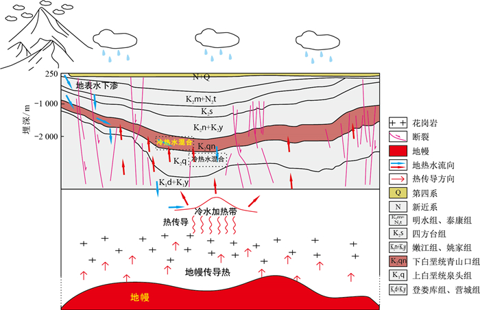
With high reservoir temperature, good lithology and high water content, the Qingshankou Formation is the best geothermal reservoir of Daqingzijing area, the saddle of the Changling Depression. Therefore, elucidating the genetic model of geothermal water is of great significance for the sustainable development and utilization of geothermal resources in this area.

Methods

In this study, the source and mixing process of geothermal water in a target area were studied by hydrochemical testing of geothermal water samples collected from 7 wells in the Qingshankou Formation, combined with 8 groups of hydrogen and oxygen isotope data, and a genetic model was established.

Results

The results show that the geothermal water of the Qingshankou Formation is mainly Cl-Na-type fluid, which is partially balanced. And the geothermal water is originated from the precipitation and primary sedimentary water in the Changbai Mountain area, with recharge elevation of 2 347-2 370 m. A geothermal fluid with a reservoir temperature of 81.25-112.80 ℃ was formed after the cyclic heat absorption process and was stored in the clastic rock reservoir of the Qingshankou Formation in a semi-open system.

Conclusion

In addition, the northeast-oriented and northwest-oriented fault systems in the study area are the main water conducting channels for geothermal fluid circulation. During the deep circulation, geothermal fluid reactions with surrounding rock minerals, resulting in the dissolution of carbonate and silicate minerals, forming geothermal water resources dominated by Na+, Cl- and HCO3- ions.

Characteristics and mechanisms of fluorine enrichment in the geothermal water of south central Shandong Province
LI Man, ZHANG Wei, LIAO Yuzhong, LIU Feng, WEI Shuaichao, HE Yujiang
2024, 43(3): 36-47. doi: 10.19509/j.cnki.dzkq.tb20230706
Abstract:
Objective

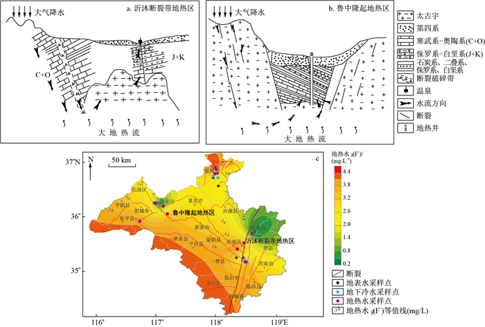
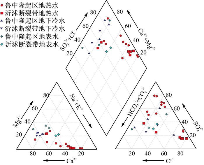
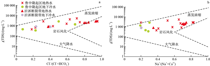
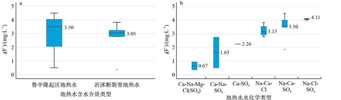
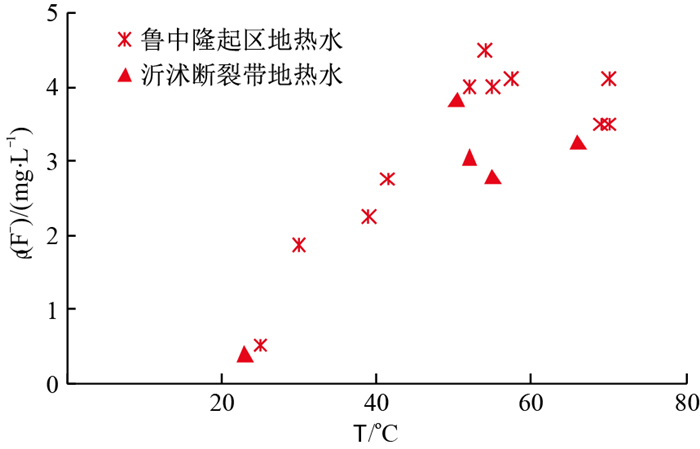
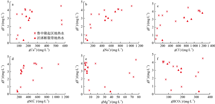
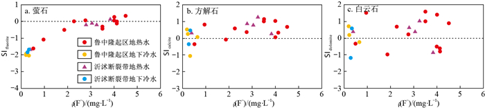
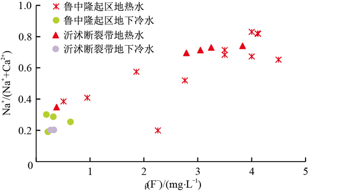
Yishu fault zone geothermal field and central Shandong uplift geothermal field are typical geothermal fields in south central Shandong Province. In order to investigated the distribution characteristics and mechanisms of fluorine enrichment in the geothermal water of the this area,

Methods

hydrochemical diagrams, geochemical simulations and principal component analysis were employed.

Results

The results show that the geothermal water in the study area is mainly Na-Ca-Cl-, Na-Ca-SO4-Cl- and Na-Cl-SO4-type water, dominated by weakly alkaline water. The predominant cation is the sodium ion, with fluorine concentration between 0.38 and 4.5 mg/L. Sodium-rich and weakly alkaline environments are faciliated to the enrichment of fluorine in the geothermal water. The fluorine concentration has significant positive correlations with the Na+, Cl- and TDS concentrations in the geothermal water. In addition, it has significant positive correlations with K+ and SO42- concentrations and significant negative correlations with Mg2+ and HCO3- concentrations in the geothermal water in the Yishu fault zone. The cation exchange effect in the geothermal water of the central Shandong uplift zone is stronger than that in the Yishu fault zone, and the reaction strength of Na+ is significantly stronger than that of Mg2+. The geothermal field of the central Shandong uplift and Yishu fault zones are both fracturing types. The thermal storage lithologies are limestone, limestone in the thermal alteration zone and ansanite in the broken belt, with strong water-rock interactions. The provenance of fluorine in the geothermal water is the dissolution reprecipitation of fluorine-containing minerals, and the fluorine concentration in the geothermal water is further increased by cation exchange and other water-rock interactions. High temperature and sodium-rich have a great influence on fluorine enrichment.

Conclusion

This research provides a reference for the exploitation and utilization of geothermal resources.

Experimental study of recirculating heat transfer in geothermal wells with nanofluids
DAI Zhaokai, YANG Xianyu, XIE Jingyu, ZHANG Jian, HOU Jiwu, LIU Mengjuan, CAI Jihua
2024, 43(3): 48-58. doi: 10.19509/j.cnki.dzkq.tb20230588
Abstract:
Objective

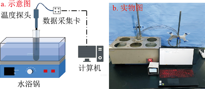
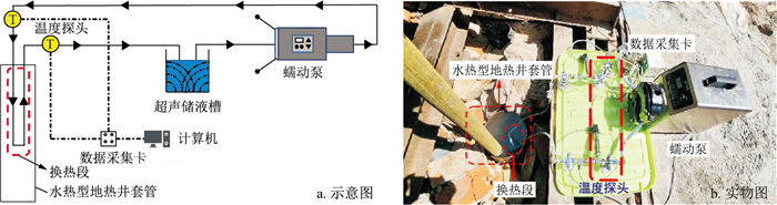
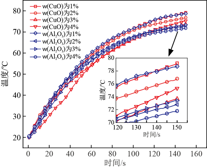
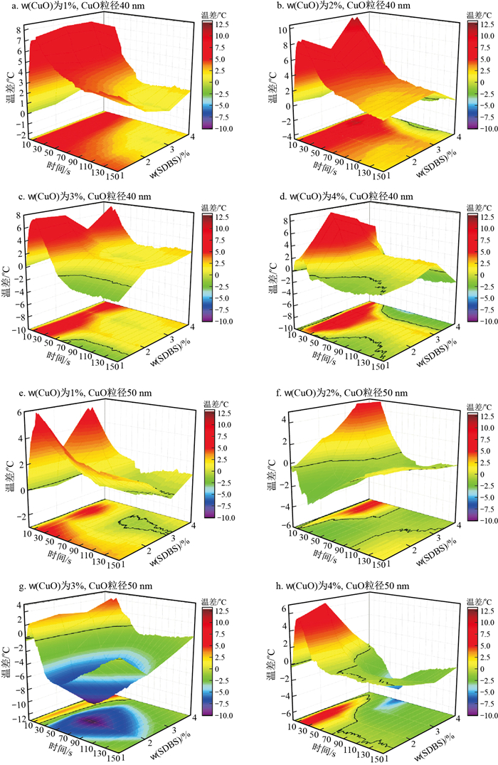
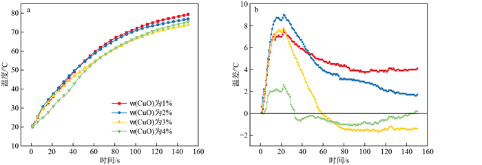
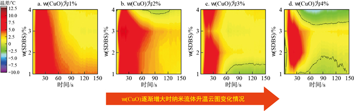
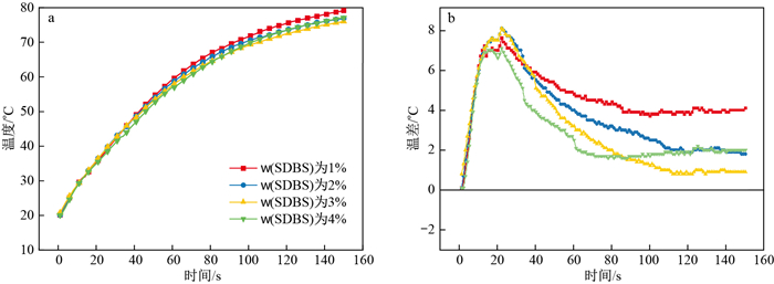
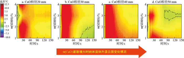
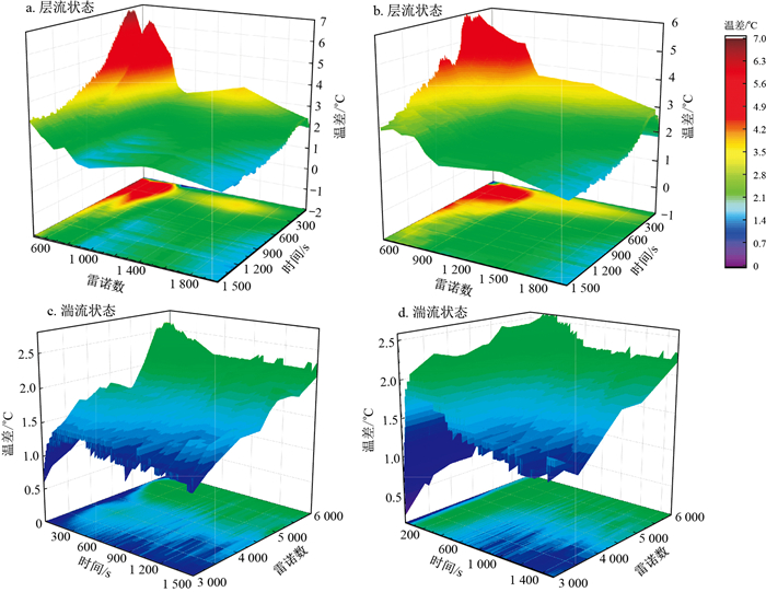
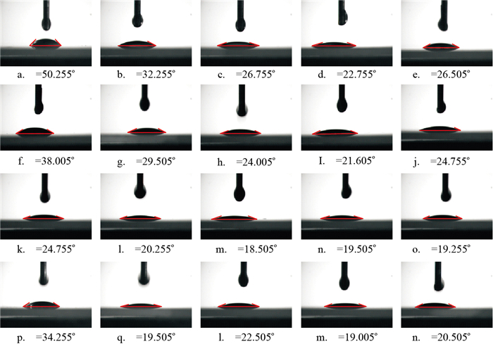
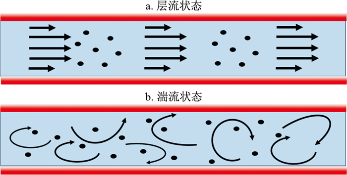
Enhancing the heat transfer performance of heat transfer media is an effective means of efficiently exploiting geothermal resources. Numerous studies have shown that the addition of nanoscale metals or metal oxides to fluids can effectively improve the heat transfer capacity of the fluid. The physical parameters that can impact the heat transfer performance of nanofluids are type, mass fraction, size of the nanoparticle, dispersant mass fraction. Additionally, the flow rate can have an important effect on the heat transfer performance of nanofluids.

Methods

In this study, spherical nano-CuO and spherical nano-Al2O3 were used as nanomaterials for configuring nanofluids. The particle size of nanomaterials ranges from 20 nm to 50 nm. Sodium dodecylbenzene sulfonate was selected as the dispersant for configuring the nanofluids. Basic heat transfer experiments are performed on nanofluids by utilizing a self-constructed basic heat transfer experimental setup. The physical parameters of the nanofluids were also optimized. In addition, a self-designed experimental setup for recirculating heat exchange was established. This experimental system uses geothermal water from hydrothermal geothermal wells as the heat source. The experimental system was also utilized for field testing in a hydrothermal-type geothermal well in Yingshan County, Hubei Province. The preferred nanofluid and deionized water from the basic heat transfer experiments were subjected to on-site circulating heat transfer experiments. Comparison of the circulating heat transfer performance of nanofluids and water under actual heat source conditions in the field. The effect of the flow rate on the heat transfer performance of nanofluids and water under real heat source boundary conditions in the field is also discussed.

Results

The results show that (1) the heat transfer performance of CuO nanofluids is better than that of Al2O3 nanofluids. (2) There is a negative correlation between the heat transfer performance of nanofluids and the nanoparticle mass fraction. (3) The nanofluid warming efficiency was highest at a 1% mass fraction of CuO nanoparticles. The nanofluid temperature increased from 25 ℃ to 79.2 ℃ in 150 s. The nanofluid temperature increased by 4.1 ℃ more than that of deionized water in the same amount of time. Moreover, the wettability of the nanofluid-heat source interface decreases with increasing nanoparticle mass fraction. The heat transfer performance of nanofluids increases and then decreases with increasing particle size. The best heat transfer performance of the nanofluid was achieved when the nanoparticle size was 40 nm. (4) The heat transfer performance of nanofluids is negatively correlated with the dispersant mass fraction. The best heat transfer performance of the nanofluid was achieved when the dispersant mass fraction was 1%. (5) The heat transfer performance of the nanofluid is negatively correlated with the flow rate when the fluid is in laminar flow. The motion of nanoparticles is progressively more intense when the fluid is in a turbulent state. This phenomenon can effectively enhance the heat transfer performance of nanofluids.

Conclusion

The research results can provide a basis for the application of nanofluids in geothermal heat transfer to improve the heat transfer efficiency of geothermal systems. It also provides theoretical references for the selection of nanofluid parameters as well as fluid flow rate parameters applied to geothermal heat transfer.

Safety analysis of geothermal water recharge coupled with CO2 geological storage system
LUO Yanan, JIANG Kunqing, HUANG Sihao, FENG Bo, BU Xianbiao
2024, 43(3): 59-67. doi: 10.19509/j.cnki.dzkq.tb20230618
Abstract:
Objective

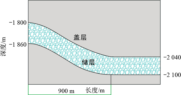
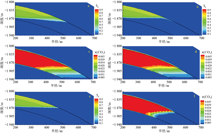
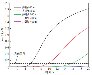
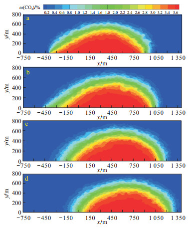
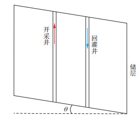
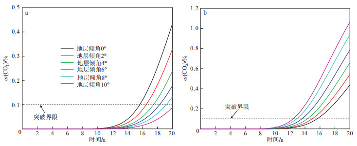
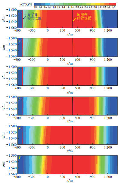
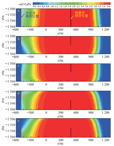
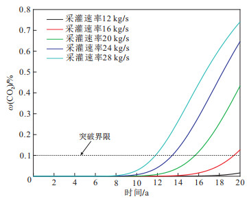
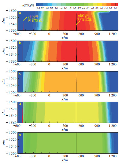
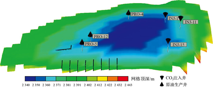
In well-trapped hydrothermal geothermal reservoirs, the research on injecting CO2 into reservoirs simultaneously with recharge water is carried out, which has both economic and environmental benefits for carbon sequestration.

Methods

A 3D reservoir model was established to study the CO2 breakthrough time and the migration of CO2-rich brine in a reservoir under different well spacings, formation inclination angles, sieve tube positions and exploitation and reinjection rates.

Results

The results show that (1) when the exploitation and reinjection rate is 20 kg/s and the well spacing is 1 200 m within 20 years of operation, there is no CO2 breakthrough. (2) In inclined formations, when the recharge well is located downstream of the production well, as the formation inclination angle increases, the CO2 breakthrough time increases, and the migration distance of carbonated water increases along the downdip direction of the formation. (3) Considering the impact of the screen position on the breakthrough time and CO2 mass fraction in the production well after breakthrough, it is beneficial to ensure the safety and effectiveness of CO2 geological storage when the recharge well sieve tube is located 30 m above the reservoir and the production well sieve is located 30 m below the reservoir. (4) The exploitation and reinjection rates have greater impacts on the CO2 breakthrough time. When the exploitation and reinjection rate is 12 kg/s, there is no CO2 breakthrough. When the exploitation and reinjection rate increases to 28 kg/s, the breakthrough time decreases to 11.8 years.

Conclusion

Therefore, in practical engineering applications, the CO2 breakthrough time can be delayed, and the safety of CO2 geological storage can be improved through the study of operating parameters and the inherent characteristics of the formation.

Application of hydrogeochemical methods in geothermal resource exploration: A case study of Yingcheng City, Hubei Province
WEI Xing, SHI Hongjie, CHEN Song, SHANG Jianbo, LIU Mingliang
2024, 43(3): 68-80. doi: 10.19509/j.cnki.dzkq.tb20230606
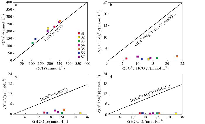
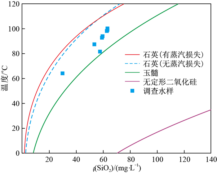
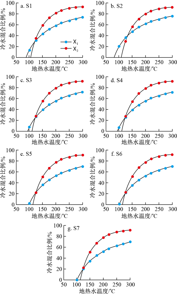
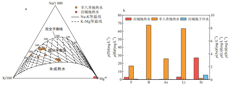
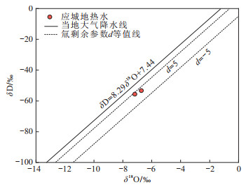
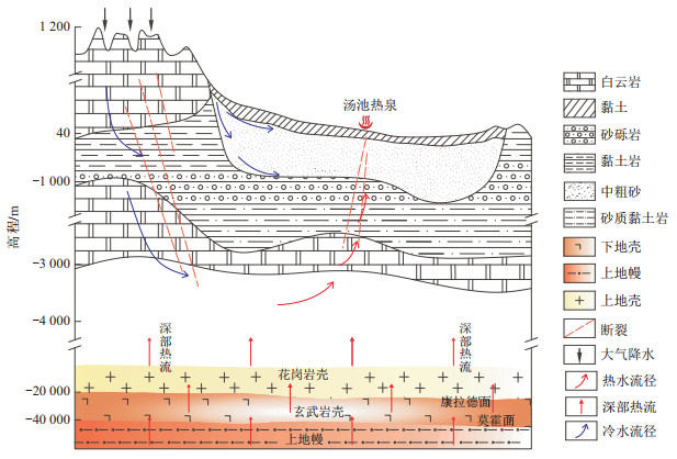
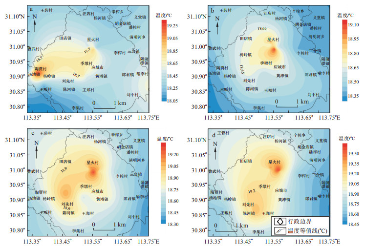
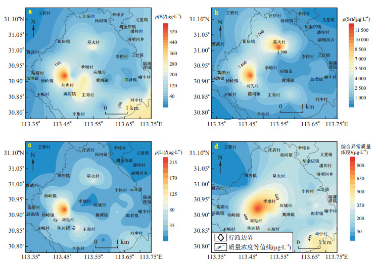
Abstract:
<p>Hydrogeochemical studies of geothermal fluid are widely used to determine the formation mechanism and occurrence environment and predict favourable exploration areas for geothermal resources.</p></sec><sec><title>Objective

In order to understand the heat source and causative mechanisms of the geothermal system, the areas of geothermal anomalies are delineated in Yingcheng City, Hubei Province.

Methods

This study examines the geochemical origins of major components in geothermal fluid and evaluates the thermal reservoir temperatures of geothermal fluid based on the hydrochemical and isotopic characteristics of geothermal water and shallow groundwater. By integrating the temperature and hydrochemical data of shallow groundwater in the area, the geothermal anomaly zones are delineated.

Results

The results show that geothermal water hydrochemistry is mainly SO4-Ca, and the main thermal storage enclosing rock of the geothermal system is marine carbonate rock, with a thermal reservoir temperature of approximately 112.2 ℃. Atmospheric precipitation infiltration and water-rock interactions in carbonate thermal reservoirs are the main sources of chemical components in geothermal water. The hydrochemical and hydrogen-oxygen isotope characteristics of the geothermal water indicate that the recharge source of the geothermal water is the precipitation from the mountainous areas in the western part of the study area.The atmospheric precipitation infiltrates from the recharge area and then continuously moves to the centre of the southeastern basin with a circulation depth of 3 436.7 m to 5 030.2 m.

Conclusion

Comparisons with the typical magma-heat source type of geothermal system as well as the results of the data of radioactive elements in the rocks, this study showed that the geothermal system of Yingcheng is formed by the heating of geothermal temperature gradient. Combined with the temperature and hydrochemistry data of the shallow underground cold water in the area, the final geothermal anomaly area is located in North of Chenhe Town Southwest of Yingchengcity, but the influence of objective constraints such as well depths and anthropogenic contamination on the results of the circle still needs to be considered.

Organic geochemical characters of source rock and significance for exploration of the Tumuxiuke Formation in Fuman area, Tarim Basin
YANG Haijun, CAI Zhenzhong, LI Yong, YANG Xianzhang, ZHANG Yintao, ZHANG Yanqiu, SUN Chong, KANG Pengfei, ZHANG Haizu, ZHAO Xingxing
2024, 43(3): 81-93. doi: 10.19509/j.cnki.dzkq.tb20220705
Abstract:
Objective

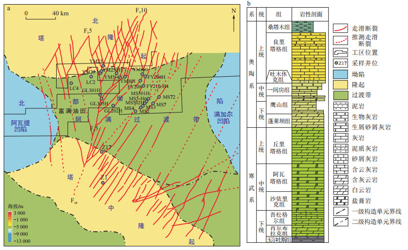
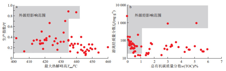
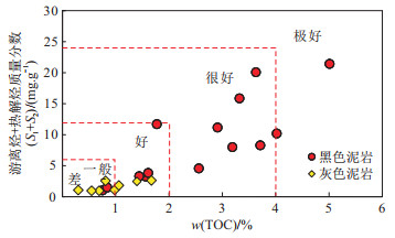
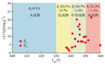
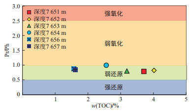
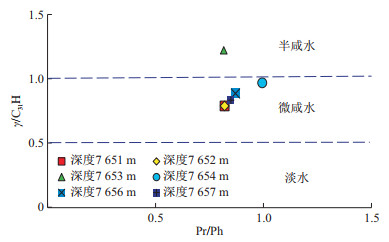
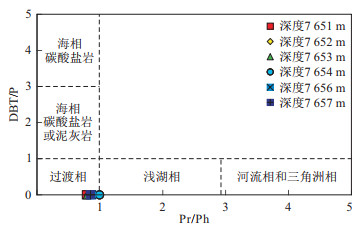
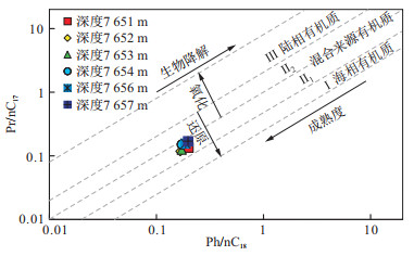
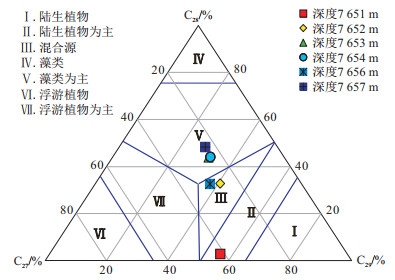
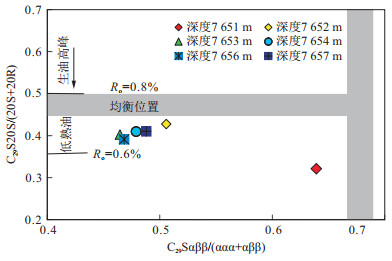
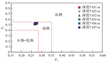
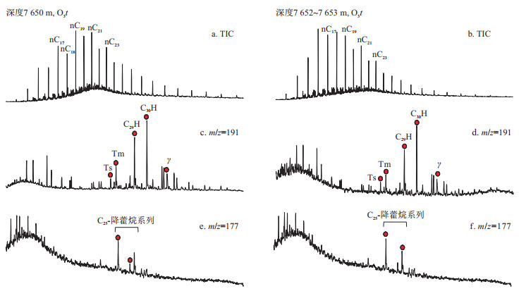
As a newly discovered source rock in the Fuman area of the Tarim Basin, the source rock of the Tumuxiuke Formation has good petroleum exploration prospects, and the geochemical evaluation of the source rock is conducive to guiding exploration.

Methods

The qualitative and quantitative characterization of drill cuttings from the Tumuxiuke Formation in the Fuman area was carried out by means of total organic carbon (TOC) content, Rock-Eval pyrolysis, and GC-MS analysis of saturated and aromatic hydrocarbons.

Results

The results show that the source rock of the Tumuxiuke Formation is a good to excellentsource rock, with an average TOC content of 3.4%. The highest hydrogen index (HI) is 590 mg/g, and the kerogen type is mainly type Ⅱ. According to the molecular geochemical characteristics, the source rock was formed in a marine sedimentary environment with weakly reducing brackish water, with aquatic algae as the primary hydrocarbon-generating organisms.Based on the peak temperature (Tmax) of Rock-Eval, saturated hydrocarbon biomarker compounds, and aromatic hydrocarbon thermal maturity parameters, the source rock of the Tumuxiuke Formation is generally in the mature-medium mature evolution stage and has good hydrocarbon generation potential.

Conclusion

As the sedimentary center of the Huanman Depression, the southern Fuman area may have thicker and higher-quality Tumuxiuke source rock with a greater degree of thermal evolution, whose contribution to the oil and gas resources in the Ordovician cannot be ignored.

Pore and fracture characteristics of low-maturity continental shale and its significance for shale oil occurrence: A case study of Shahejie Formation in Qingnan Sag, Jiyang Depression
WANG Weiqing, WANG Xuejun, LI Zheng, WANG Yuhuan, FENG Luchuan, LI Pengbo
2024, 43(3): 94-107. doi: 10.19509/j.cnki.dzkq.tb20230321
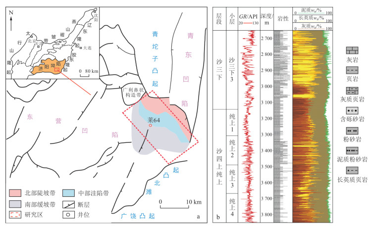
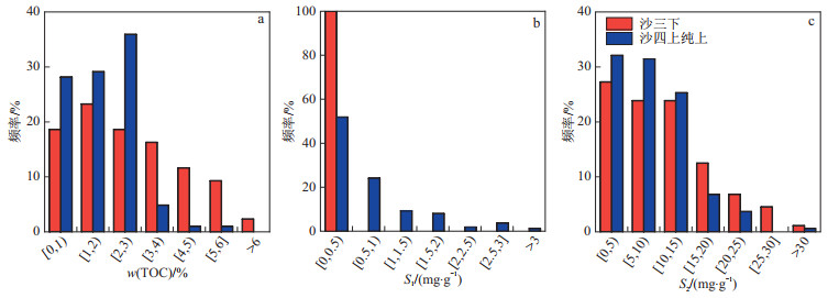
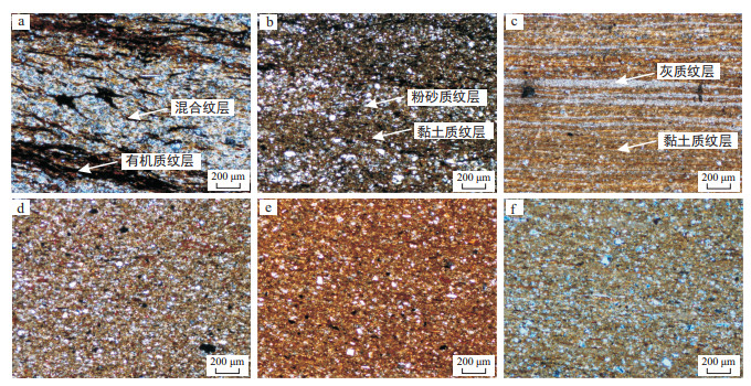
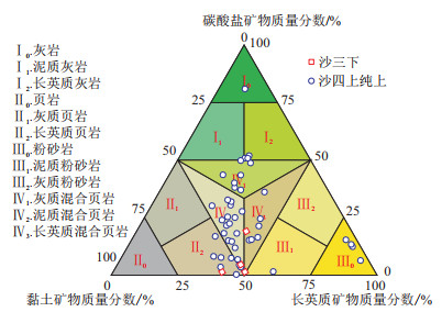
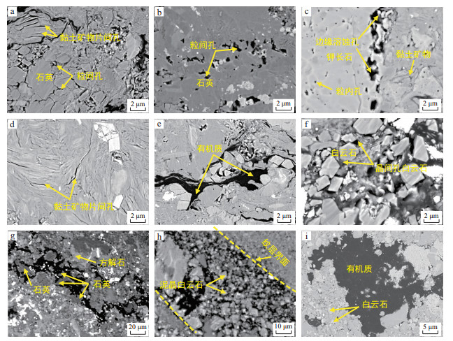
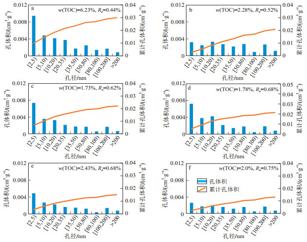
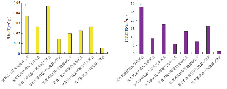
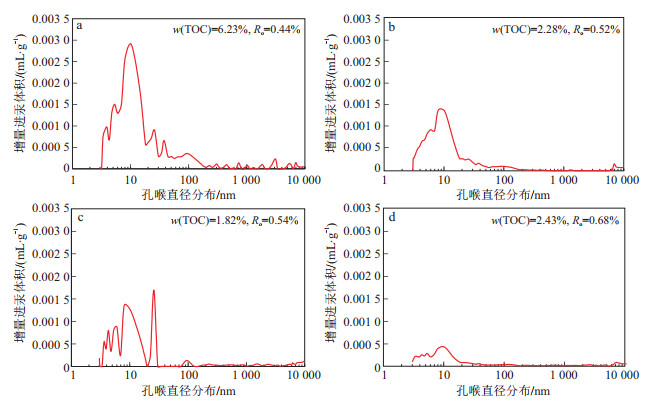
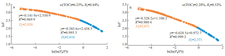
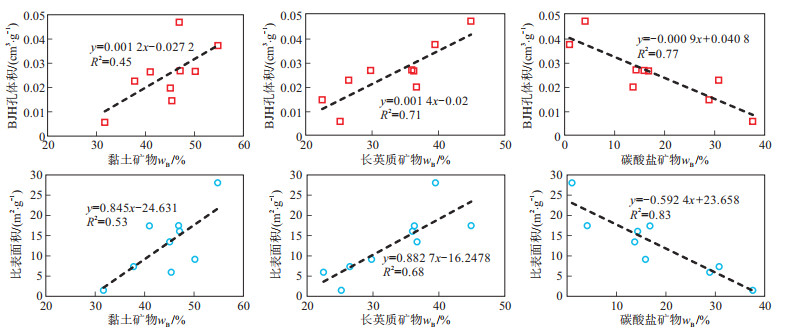
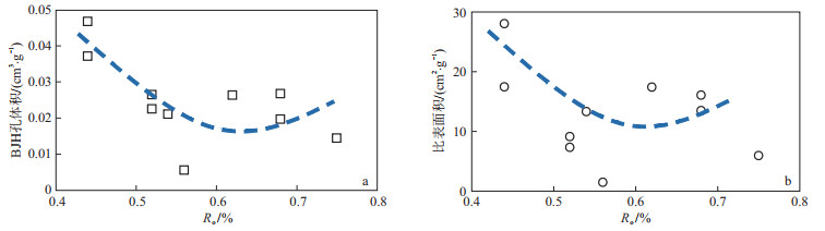
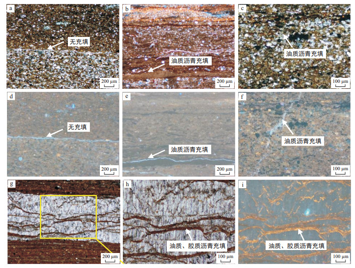
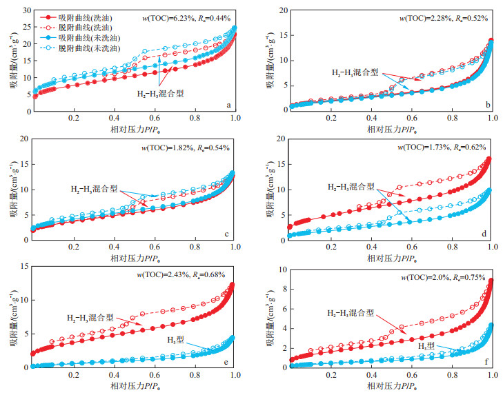
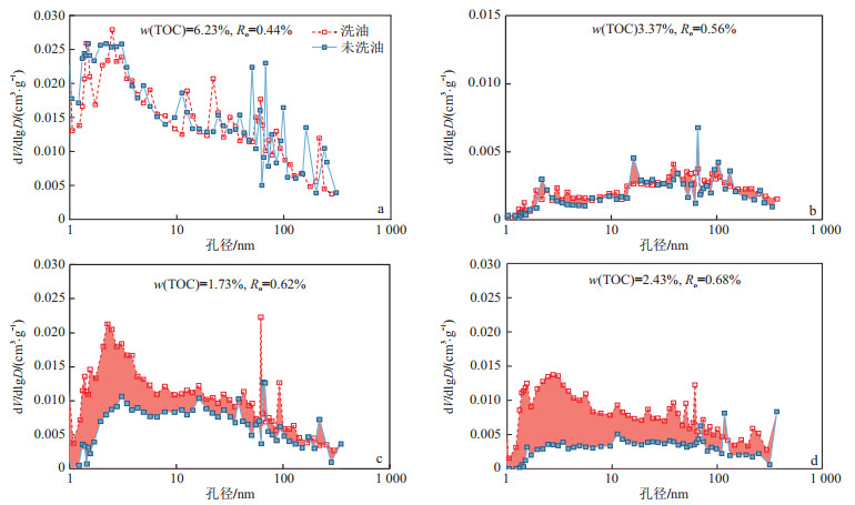
Abstract:
<p>Low-maturity shale oil has great resource potential in Jiyang Depression and has become an important field after the successful breakthrough of medium- to high-maturity shale oil.</p></sec><sec><title>Objective

The purpose of this paper is to clarify the pore and fracture characteristics of low-maturity continental shale and their significance to shale oil occurrence.

Methods

By studying the Es3x and Es4scs members in Qingnan Depression, Jiyang Depression, this study combines thin section observation, TOC content, XRD analysis, solvent extraction, low-temperature N2 adsorption, high-pressure mercury injection, scanning electron microscope observation and EDS analysis to classify the shale lithofacies, characterize the pore and fracture development, and illustrate the importance of shale pores and fractures for shale oil occurrence.

Results

The TOC content is mostly in the range of 1.0%-4.0%, and the mineral composition mainly includes felsic minerals, followed by clay and carbonate minerals. The major pore types are ink-bottle-shaped pores and plate-parallel-shaped pores, including quartz intergranular pores, clay mineral interlamellar pores, and dolomite intercrystalline pores. The major pore sizes are mostly less than 200 nm and exhibit a multipeak distribution, which is concentrated in the ranges of 2-50 nm, 50-80 nm and 100-200 nm. Horizontal bedding fractures, vertical fractures and network fractures developed in the studied shales and were mostly filled or contacted by bitumen.Felsic-rich shale lithofacies usually have a greater pore volume and specific surface area than clay-rich lithofacies, and felsic minerals positively contribute to pore development. The pore volume and specific surface area first decreased and then increased with increasing thermal maturity. When Ro>0.6%, the shale oil content increases significantly, which is mainly related to the large amount of hydrocarbon generation in organic matters.

Conclusion

Horizontal bedding fractures, quartz intergranular pores, and dolomite and calcite intercrystalline pores are favourable storage and occurrence spaces for shale oil.

Role of the large-scale strike-slip transform zone in controlling the differential hydrocarbon distribution: A case of the Côte d'Ivoire Basin in West Africa
RAO Yong, CHENG Tao, ZHAO Hongyan, LI Quan, LÜ Caili, LIU Zheng
2024, 43(3): 108-119. doi: 10.19509/j.cnki.dzkq.tb20230119
Abstract:
Objective

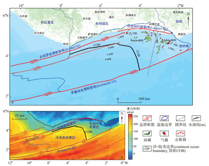
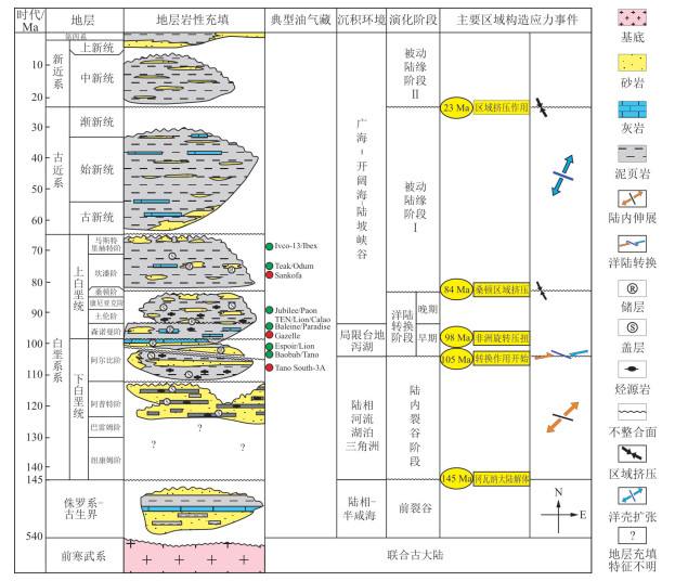
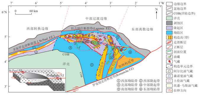
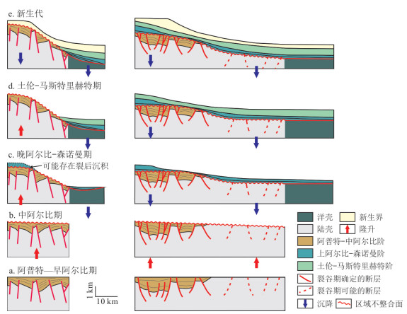
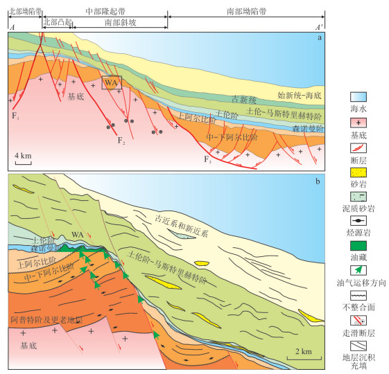
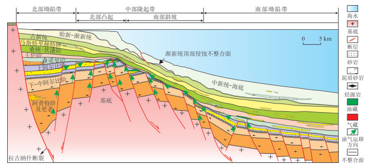
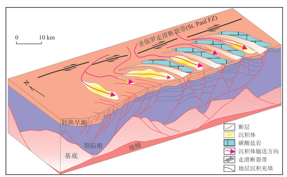
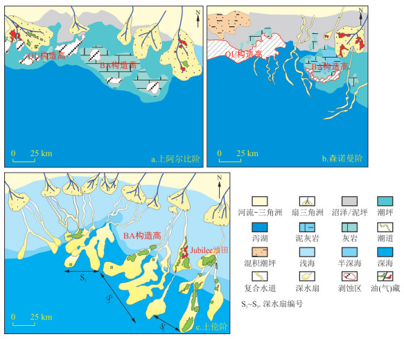
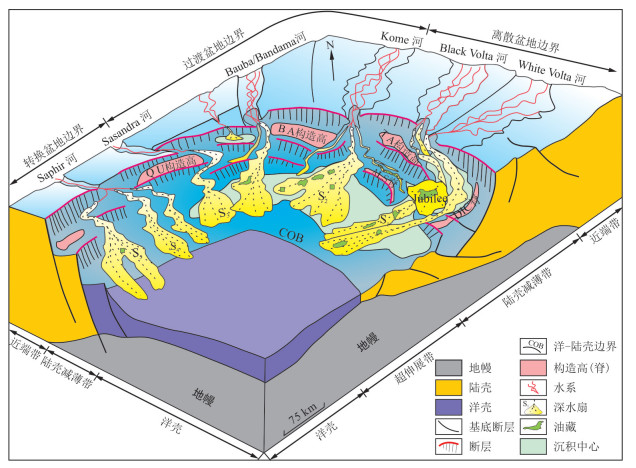
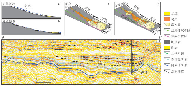
The Côte d'Ivoire Basin, which is located in the equatorial section of West Africa and features large-scale strike-slip transform zones, is a typical transformed passive continental margin basin. This area is currently a hot spot for oil and gas exploration and has great exploration potential but has an uneven distribution of hydrocarbons both horizontally and vertically.

Methods

Based on previous results, well data, seismic data and new discoveries, this paper focuses on the differential controls of hydrocarbon distribution from two perspectives: structure and sedimentation.

Results

The results show that the basin has experienced three main tectonic-sedimentary evolution stages, namely, intracontinental rift, ocean-continent transition, and passive margin, forming the "narrow west-wide east" axe structure. The basin has a narrow and steep transform margin in the west, a wide and gentle divergent margin in the east, and a transitional margin in the central region, which controls the overall oil and gas distribution of "less in the west and more in the east" in macro-scale. The main response area of the strike-slip transformation stress in the central transitional margin and the central uplift developed many structural traps, which were sourced from both the northern and southern depression and ultimately controlled the distribution of the Albian oil and gas reservoirs.

Conclusion

The palaeomorphology formed by the strike-slip transform zone plays an important role in controlling the spatial distribution of both the Upper Albian-Cenomanian reservoirs in the early stage and the Turonian reservoirs in the late stage. The stepped or intra-slope ponds on slopes formed by strike-slip transform zone are often the most favourable sand-rich places and benefit stratigraphic-lithologic traps. Additionally, the distribution of oil and gas reservoirs has good consistency with the distribution of sedimentary systems; that is, the transformation controls the reservoirs, and the distribution controls the oil and gas reservoirs.

Structure and evolution of faults in central and northern parts of Tazhong Uplift, Tarim Basin
JIANG Zhongzheng, TANG Daqing, SHA Xuguang, SHEN Xiangcun, LUO Shaohui, DONG Keliang, GUZAILINUER·Aierken, WANG Weilong, WU Liang
2024, 43(3): 120-132. doi: 10.19509/j.cnki.dzkq.tb20220663
Abstract:
Objective

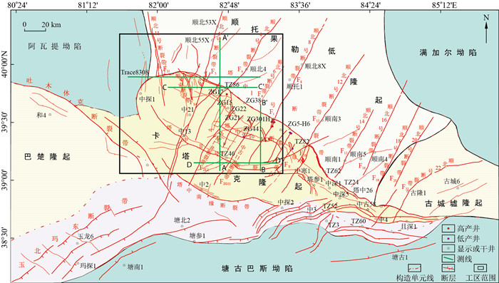
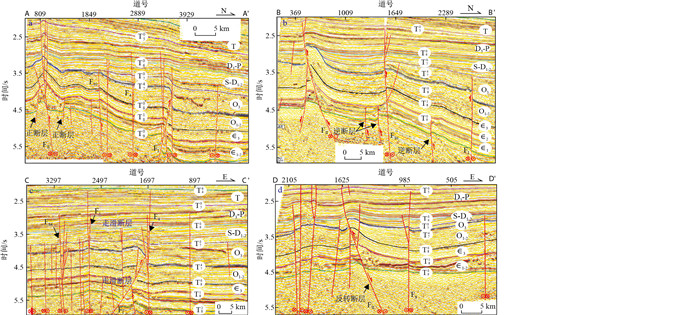
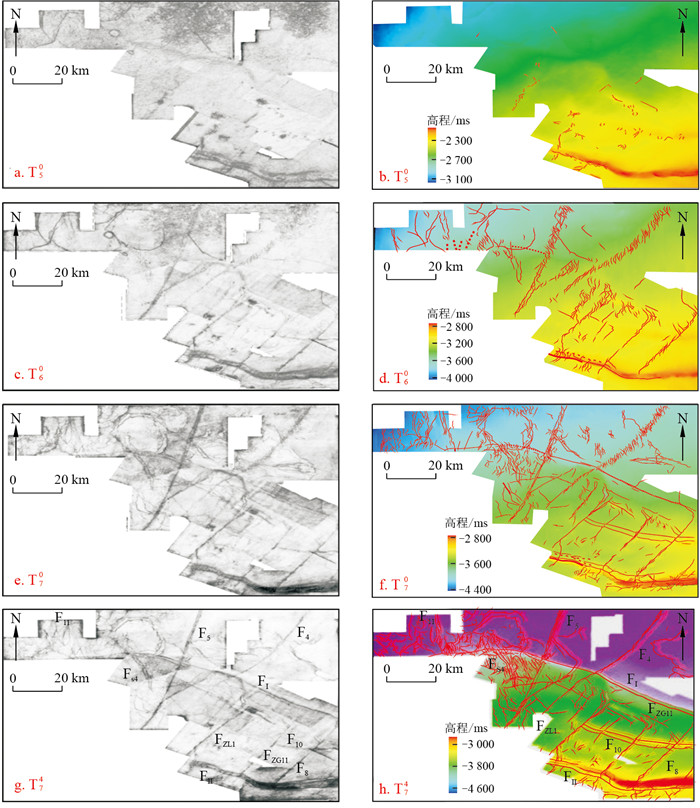
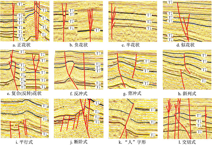
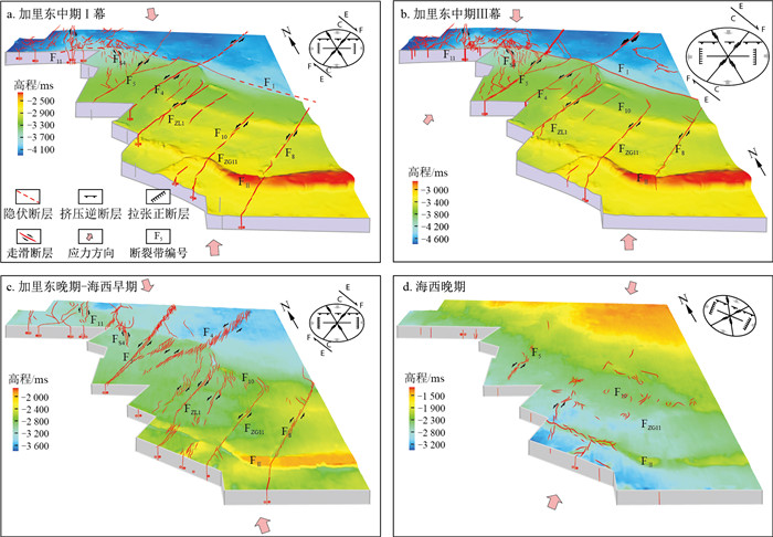
To reveal the structures and evolutionary patterns of faults in the central and northern parts of Tazhong Uplift, Tarim Basin,

Methods

this paper systematically discusses the types of fault structures, geometric characteristics, differential activity mechanisms, and tectonic evolution processes in this area by analysing detailed structural interpretations and coherent slices of combined large 3D seismic data along with the regional dynamic background.

Results

The results show that there are 4 types and 7 evolution stages of faults in the central and northern parts of Tazhong Uplift, among which thrust faults and strike-slip faults are particularly common. On the plane, NW arc thrust faults intersect with NE-, NW- and NS-striking strike-slip faults; vertically, the fault stratification and differential activity characteristics are obvious. In the Lower Ordovician and the belowing layers, faults developed in large numbers and were mainly linear in their trending directions. As for the Middle Ordovician-Middle and Lower Devonian layers, faults are mostly in the echelon type. In the Upper Devonian-Permian layers, a few faults developed in the Tazhong Ⅱ fault zone and the southwestern end of the Shunbei 5 fault zone.

Conclusion

The fault activity in the study area was controlled by stress sites exhibiting diverse properties across multiple phases and directions and experienced an extremely complex evolutionary history: In the Early Caledonian period, a small number of normal faults, such as the Tazhong Ⅱ fault zone, were mainly active; in the Middle Caledonian Ⅰ period, the fault activity was very strong and was characterized by coevolution and mutual coupling of thrust faults and strike-slip faults. The strike-slip faults obviously cut or restricted the thrust faults. The fault activity of the Middle Caledonian Ⅲ period basically inherited the tectonic framework of the Middle Caledonian Ⅰ period, but the characteristics of transtensional fault activity in the Shunbei 4 and 5 fault zones are significant. From the Late Caledonian to Early Hercynian, some of the faults inherited activities with obvious transtensional characteristics. Conversely, in the Indochina-Yanshan period, only a few faults inherited activity, and the development area of transtensinal fault is further expanded to the south. During the Himalayan period, the tectonic movement of this area was relatively stable, and the complex fault structures that formed in the early stage transitioned into the deep burial stage.

Characteristics and geodynamic background of the coal-controlled structural patterns in the Qianyingzi Coalmine, Huaibei Coalfield
WANG Weimin, GU Chengchuan, CHENG Longyi, WU Jiwen, ZHAI Xiaorong
2024, 43(3): 133-146. doi: 10.19509/j.cnki.dzkq.tb20230436
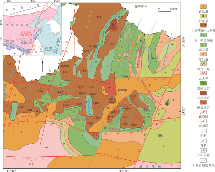
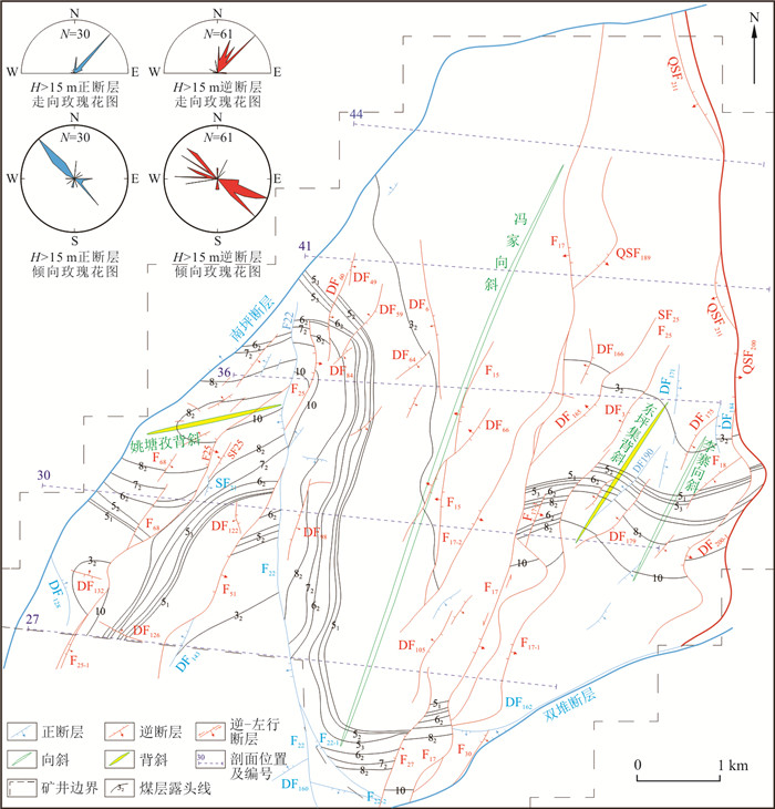
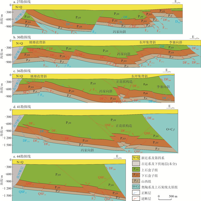
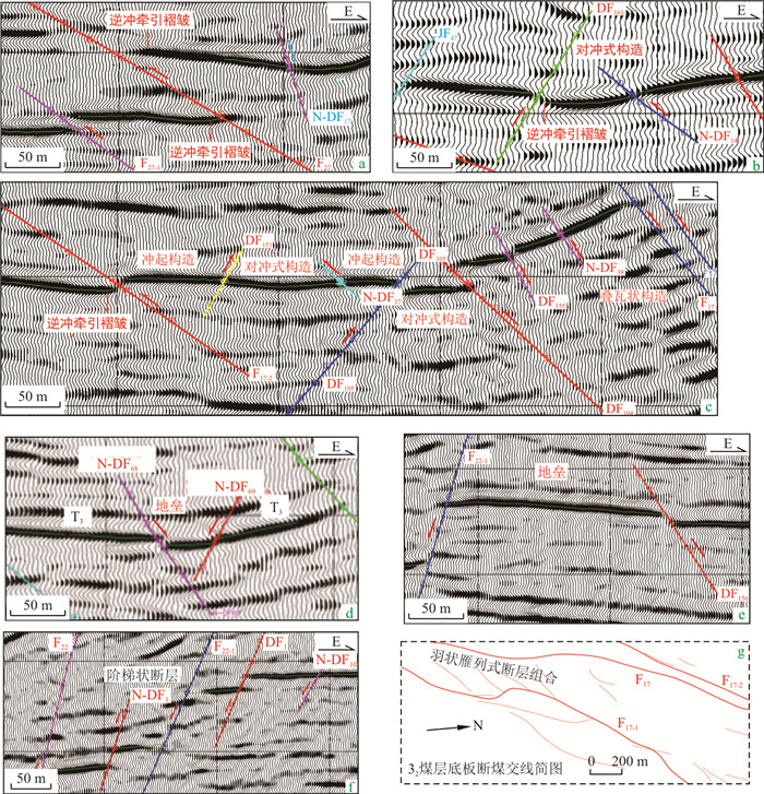
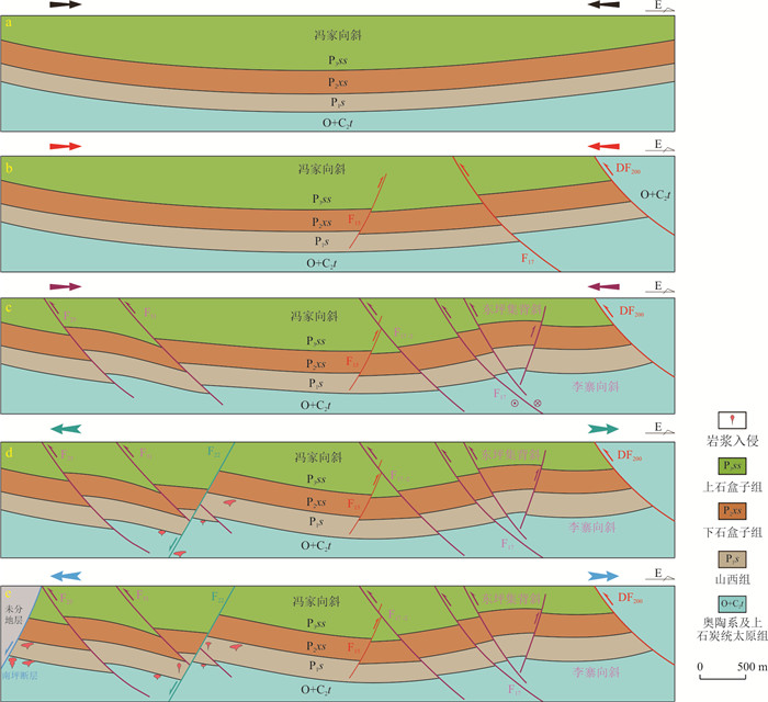
Abstract:
<p>The Qianyingzi Coalmine is located on the west of the Suxian Mining area of the Huaibei Coalfield, adjacent to the outer edge of the southern segment of the Xu-Su Arc Nappe Belt.</p></sec><sec><title>Methods

Based on the latest geological exploration and production data, this paper analysed the structural framework and coal-controlled structural patterns of the Qianyingzi Coalmine, divided the tectonic stages, and discussed the geotectonic background of the coalmine structures,

Objective

which provides an important geological basis for the understanding of the tectonic deformation and evolution of the coalmine, the geodynamic mechanism and the prediction of exploration directions.

Results

The results show that the Carboniferous-Permian coal-bearing formations in the mine are generally a gentle syncline with an NNE-trending axis. The faults in the mine are well developed, and the number of reverse faults is greater than that of normal faults. Both of these faults are mainly NE to NNE, followed by NS. The structural framework of this mine is significantly controlled by several large NS to NE-striking faults and is segmented from west to east by major faults, including the Nanping, F22, F17, DF200 and Shuangdui faults, which exhibit the characteristic of east and west zonation. The coal-controlled structural patterns in the mine can be classified into three types, namely, compressional, extensional and strike-slip. And the coal-controlled patterns can be further divided into nine subtypes, namely, thrust drag folds, hedge structures, pop-up structures, imbricate structures, grabens, horsts, step faults, positive flower structures and pinnated en-echelon structures. The analysis of structural combinations shows that the F17 fault has not only thrusting motion but also significant transcurrent activity.

Conclusion

The structural deformation of coal-bearing formation in the Qianyingzi Coalmine can be divided into five stages: the Fengjia Syncline with an NNE-trending axis, nearly NS-striking reverse faults, NNE-striking reverse-sinistral faults and NE-striking reverse faults, nearly NS-striking normal faults, and NW-SE-striking normal faults. Combined with the results of previous studies on the regional tectonic background, the first and second shortening structures in this mine are the results of foreland deformation during the convergence of the North China Craton and South China Plate and subsequent continent-continent collisional deformation during the Indosinian period. The third stage compresso-shear structures are related to the rapid oblique subduction of the Izanagi Plate toward the East Asian continental margin at the beginning of the Early Cretaceous in the Western Pacific. The fourth and fifth stage extensional structures developed against a strong extensional background in eastern China during the Early Cretaceous.

Research on the main control factors of carbon dioxide flooding and storage based on random forest algorithm
REN Junfan, XUE Liang, NIE Jie, XIAO Lei, LIAO Guangzhi
2024, 43(3): 147-156. doi: 10.19509/j.cnki.dzkq.tb20230699
Abstract:
Objective

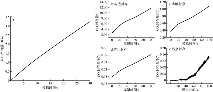
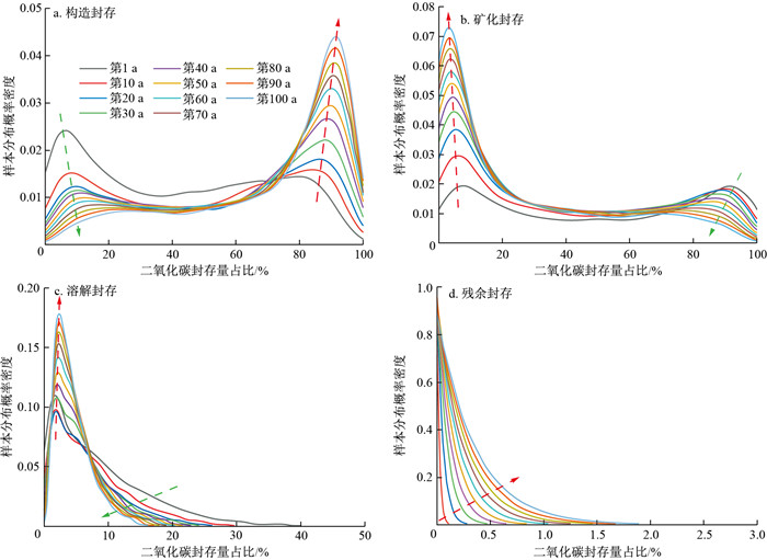
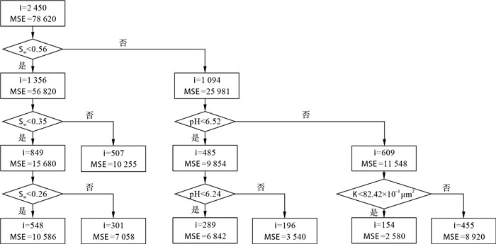
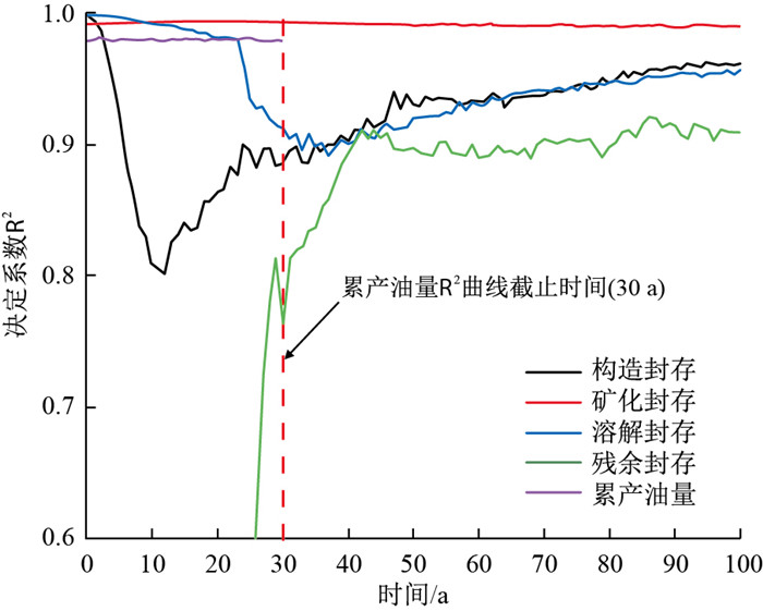
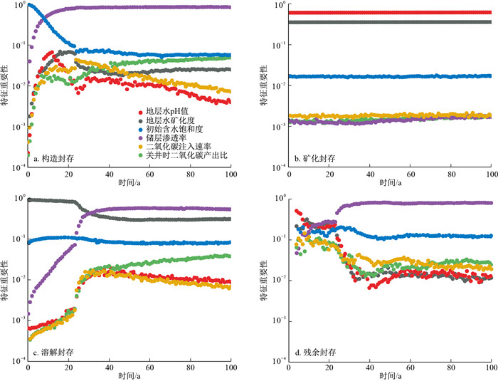
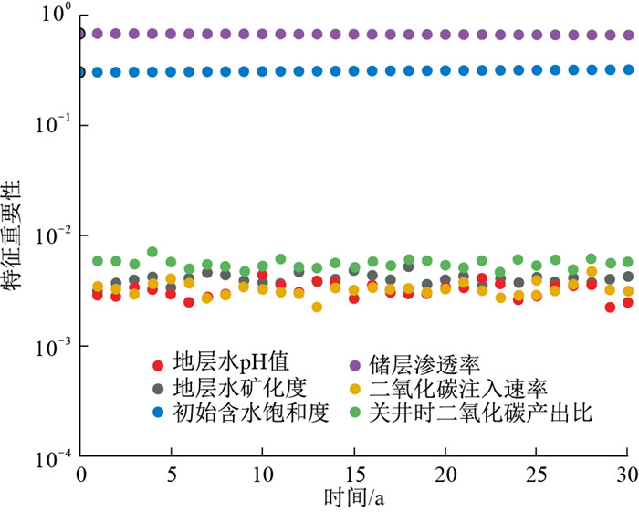
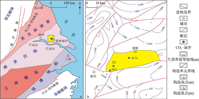
To achieve carbon peak and carbon neutrality goals, carbon dioxide flooding and storage are the main technical means for carbon emission reduction. It is crucial to clarify the main controlling factors of carbon dioxide flooding and storage under reservoir conditions, which provides the basis for realizing the efficient development of carbon dioxide flooding and storage.

Methods

In this study, with the widely used PUNQ-S3 case study as the basis, an integrated numerical simulation model of carbon dioxide flooding and geological storage is constructed. It considers the miscible interaction between carbon dioxide and crude oil as well as storage mechanisms, including structural, residual, dissolved, and mineral trapping. By employing the random forest intelligent algorithm, a feature importance analysis of reservoir and production parameters during the carbon dioxide flooding and storage process is carried out. The differences between carbon dioxide flooding and storage at different time scales are considered. A time series-based feature importance analysis method is established, and the main controlling factors in the different carbon dioxide flooding and storage stages are analysed. Through the fluctuation of the evaluation index, the influence of reservoir and production parameters on different stages of carbon dioxide flooding and storage is inferred.

Results

The results show that the time series-based random forest model for carbon dioxide flooding and storage has high accuracy. In the early stage of carbon dioxide flooding and storage, the amount of carbon dioxide structural storage is controlled by the reservoir water saturation, and the amount of dissolved storage is controlled by the salinity of the formation brine; In the middle and later stages of carbon dioxide flooding and storage, the amount of carbon dioxide structural storage is controlled by reservoir permeability, while the amount of dissolved storage is controlled by reservoir permeability and formation water salinity; The residual storage capacity is small in the early stage of carbon dioxide flooding and storage, resulting in unclear main controlling factors.In the later stage of carbon dioxide flooding and storage, it is controlled by reservoir permeability and water saturation; The amount of mineralization storage is controlled by the pH value and the salinity of the formation brine throughout the entire CO2 flooding and storage stage; The amount of carbon dioxide production is controlled by reservoir permeability and water saturation throughout the entire carbon dioxide flooding and storage stage.

Conclusion

The time-series-based random forest algorithm can identify the main controlling factors of different carbon dioxide flooding and storage stages and can provide support for cimproving crude oil recovery and implementing efficient geological storage with carbon dioxide.

Formation time and fluid source of calcite veins and geological significance: An example from the Triassic Qinglong Formation carbonate reservoirs in the Huangqiao area, Subei Basin
CHEN Junlin, HUANG Yahao, GUO Xiaowen, LUO Tao, WANG Yanlei, ZHANG Xuyou, HU Zhiqi, JIANG Hongman, WANG Yang
2024, 43(3): 157-169. doi: 10.19509/j.cnki.dzkq.tb20230099
Abstract:
Objective

Calcite veins are the products of tectonic diagenesis. Information about fracture opening and fluid activity was recorded by calcite veins.

Methods

Multiple approaches, consisting of thin section observation, cathodoluminescence, U-Pb isotope dating, and REE, C, O and Sr isotope analyses of calcite veins from the Triassic Qinglong carbonate reservoirs in the Huangqiao area, Subei Basin, are used to analyse the origin of vein-forming fluid.

Results

Four stages of calcite veins were identified in the Qinglong Formation and successively formed at (115.30±0.42), (97.03±0.43), (85.29±0.25), (45.5±19.0) Ma. In the first stage, the calcite veins were derived from deep hydrothermal fluids.And in the second stage, the calcite veins were derived from mixed fluids of atmospheric fresh water and seawater. Formation water and deep shell-source hydrothermal fluid mixed in the vein-forming fluid of the third-stage calcite veins. In the fourth stage of calcite veins formation, deep mantle-source hydrothermal fluid mixed with the formation water, resulting in the precipitation of calcite veins. The formation timing of the four stages of calcite veins corresponds to multistage tectonic movements during different periods, indicating that fluid evolution in the Triassic Qinglong carbonate reservoirs was controlled by multiple stages of tectonic movements.

Conclusion

Importantly, three stages of deep hydrothermal fluid injectionin the reservoir were the result of deep fault opening caused by tectonic movements, which possibly indicate multistage hydrocarbon accumulation in the Triassic Qinglong Formation in the Huangqiao area.

Tectonic evolution and prototype basin reconstruction in the Jimsar and Jinan depressions, eastern Junggar Basin
XIA Shiwei, MA Qiang, HUANG Chuanyan, ZHANG Wei, LI Xiaopeng, ZHANG Hong, MA Jianghao, PENG Yazhong, NIE Feng
2024, 43(3): 170-179. doi: 10.19509/j.cnki.dzkq.tb20230095
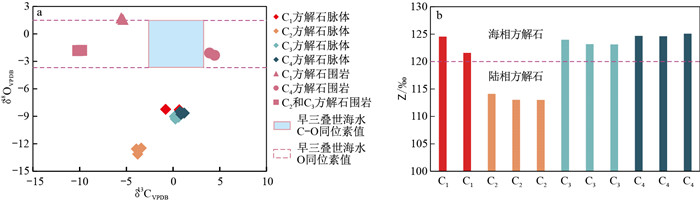
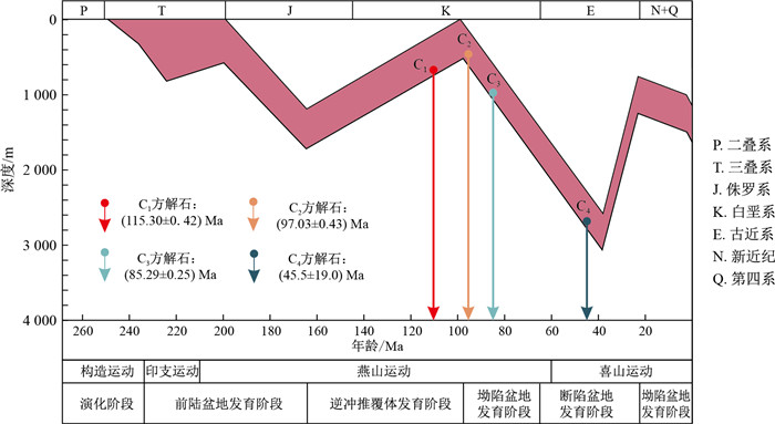
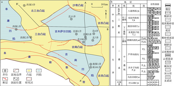
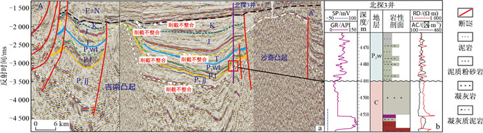
Abstract:
<p>Since 2020, with in-depth research on the Shuangji structural belt in the Jimsar Depression, Junggar Basin and high-yield oil flow data obtained from the Triassic Jingjingzigou Formation in the Well Satan 1, it has been demonstrated that the Jimsar and Jinan depressions have promising potential for conventional oil and gas exploration.</p></sec><sec><title>Objective

To further study the geological characteristics and exploration potential of the Jimsar and Jinan depressions,

Methods

this paper comprehensively analyses data from core samples, logging, well logging, and seismic surveys; identifies regional unconformities; categorizes different tectonic stages; and establishes the correlation between tectonic and stratigraphic evolution. Based on this, the development process of each stratum is restored, and the coupling relationship between tectonics and the evolution of uplift and depression within the research area is established, and the prototype basin is restored.

Results

This study revealed five large unconformities in the Jimsar and Jinan depressions, which have undergone four episodes of tectonic activity. The stratigraphic evolution characteristics of the study area ranged from "north high and south low" in the Early Permian to "south high and north low" in the Palaeogene and Neogene. The original basin also changed from a "multiconvex and multiconcave" pattern in the Early Permian to a "few convex and large concave" structural pattern in the Palaeogene and Neogene.

Conclusion

The establishment of the coupling relationship between tectonics and the evolution of uplift and depression at different times and the restoration of the prototype basin during each period lays an important foundation for clarifying the basin characteristics of the Jimsar and Jinan depressions during different periods and helps to enhances oil and gas exploration in these areas.

Characteristics and formation period of fractures in the reservoirs of Permian Maokou Formation, Zigong area, Southwest Sichuan Basin
MA Kexin, HU Mingyi, SHI Jinxiong, DENG Qingjie
2024, 43(3): 180-191. doi: 10.19509/j.cnki.dzkq.tb20230613
Abstract:
Objective

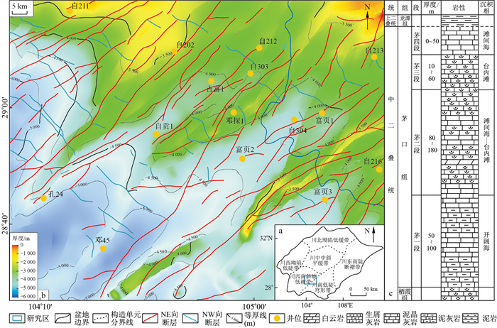
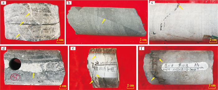
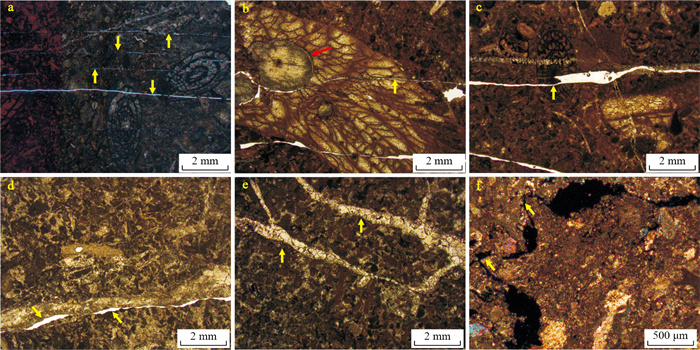
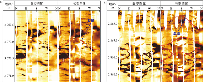
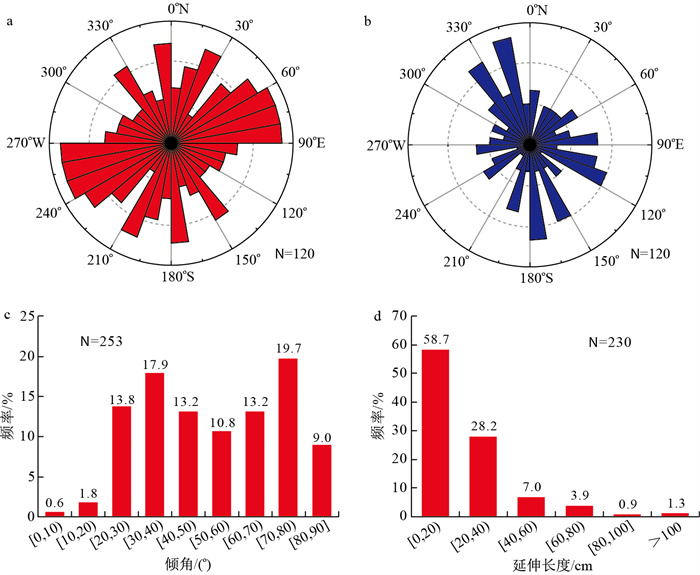
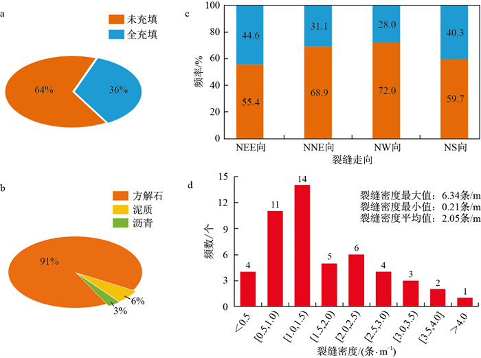
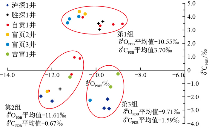
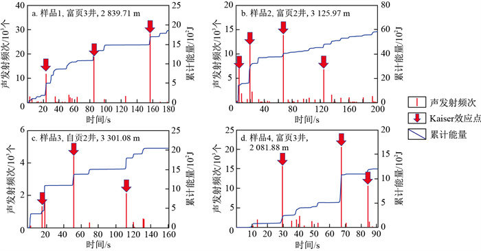
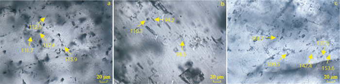
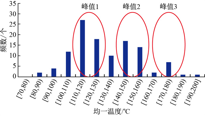
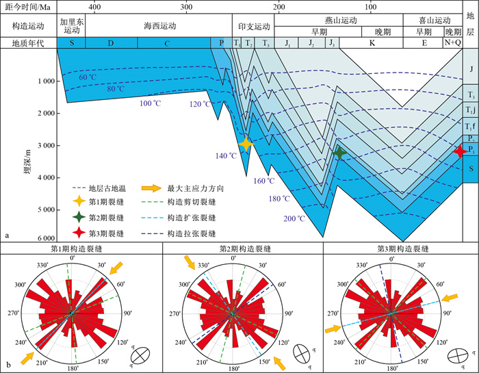
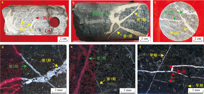
Fractures commonly occur in the marine carbonate reservoirs of Permian Maokou Formation in Zigong area of Sichuan Basin and have important impacts on reservoir properties, seepage patterns and hydrocarbon enrichment.

Methods

Cores, thin sections, image logs and experimental test data were used to clarify the type of fracture genesis and development characteristics, analyse the time of fracture formation, and determine the period of fracture formation.

Results

The results show that the marine carbonate reservoirs of Maokou Formation in Zigong area are divided into two types, namely, tectonic fractures and diagenetic fractures, among which the tectonic fractures include tectonic shear fractures and tectonic tensile fractures, and the diagenetic fractures include horizontal bedding fractures and diagenetic sutures. Tectonic shear fractures dominate Maokou Formation reservoir and occur mainly in the NEE and NNE directions. The fracture inclination angle ranges from 20° to 80°, and the extension length is less than 60 cm. The fracture degree of filling is low, and the validity is good. Combined with the analysis and test data, the reservoir fractures of Maokou Formation in Zigong area were determined to have formed by 3 stages of structural movement. The first stage included the late Hercynian and early Indosinian periods, approximately 240-220 Ma. Under the SW stress derived from the clockwise movement of the South China Plate, a small number of shear fractures developed, and the fractures were mostly filled with minerals, representing the secondary development period of fractures. The second stage occurred in the late Yanshan-early Himalayan period, approximately 78-69 Ma, and a large number of tectonic fractures developed under the NW-trending stress generated by the Xuefeng uplift in Jiangnan, which was the main period of fracture formation in the study area. The third period was the late Himalayan period, approximately 13-0 Ma. Fractures were formed under the NEE compressive stress generated by the collision of Indian Ocean Plate, and most of the fractures were unfilled, indicating good effectiveness.

Conclusion

The above fracture-related research provides the basis for establishing favourable exploration zones in the study area.

Optimizing TSES method based on the environmental factors to select negative samples and its application in landslide susceptibility evaluation
CUI Yulong, ZHU Lulu, XU Min, MIAO Haibo
2024, 43(3): 192-199. doi: 10.19509/j.cnki.dzkq.tb20230400
Abstract:
Objective

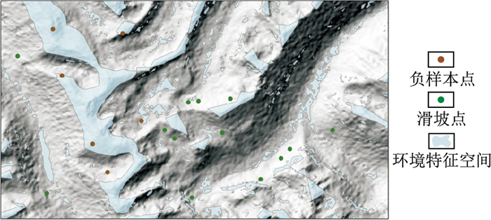
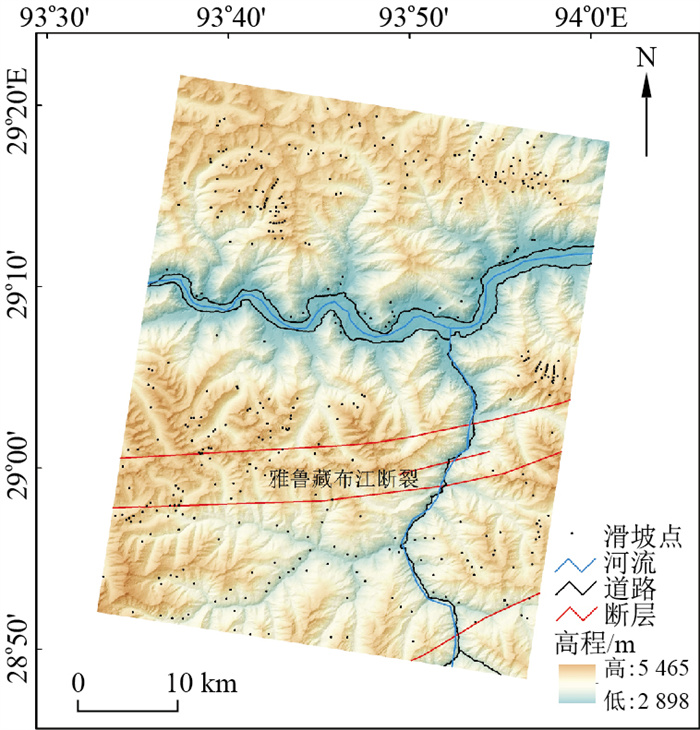
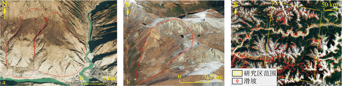
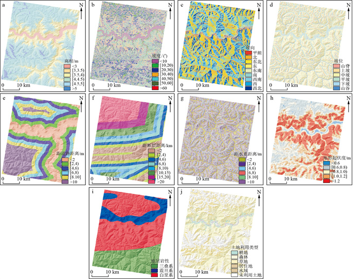
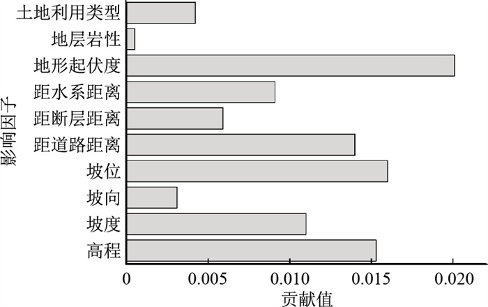
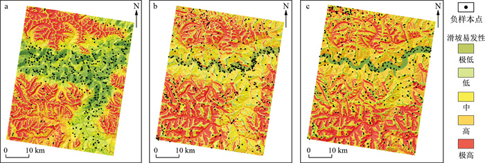
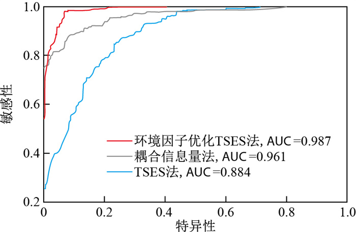
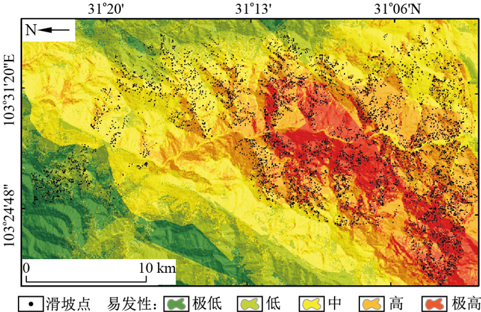
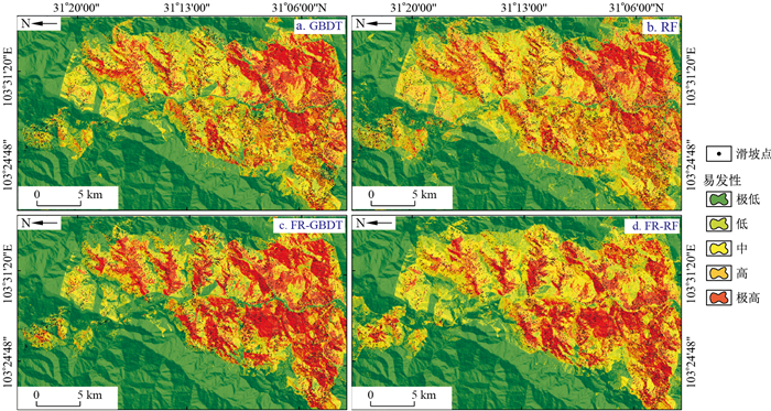
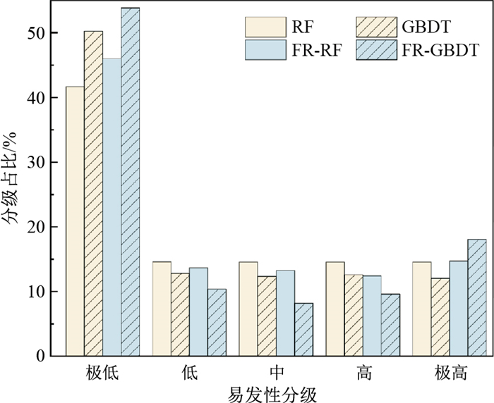
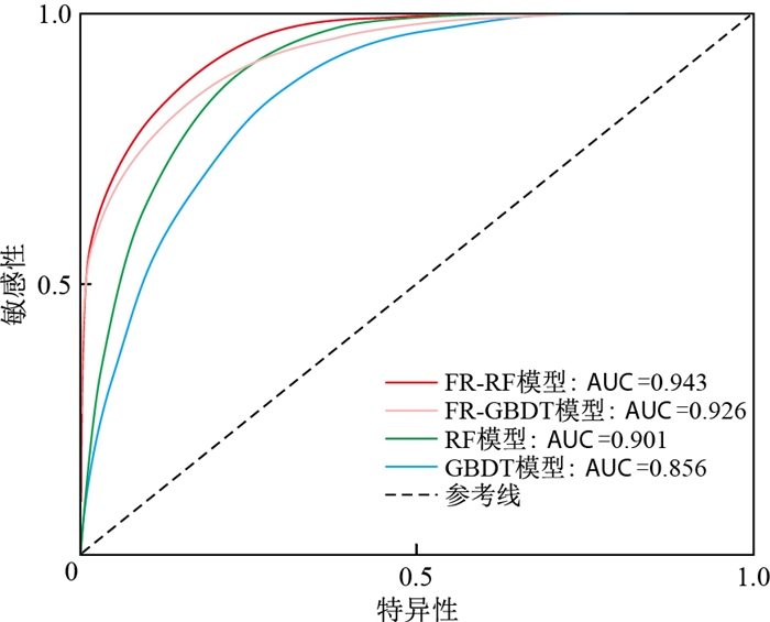
Landslide susceptibility evaluation is an important means for landslide disaster prevention and control. Unreasonable negative landslide samples will affect landslide susceptibility evaluation, thereby affecting landslide disaster prevention and control. Therefore, it is particularly critical to provide a reasonable negative sample selection method.

Methods

In view of the selection of negative landslide samples, the ancient landslides in Milin City, Xizang are taken as an example, and 10 environmental factors, including elevation, slope, slope aspect, slope position, distance to road, distance to fault, distance to water system, topographic relief, lithology and land use type, are selected. The Relief algorithm is used to calculate the contribution values of environmental factors and to select the optimized environmental factors. The target space exteriorization sampling (TSES) method based on the optimization of environmental factors is applied to select negative samples as the input variables of the random forest (RF)model with excellent performance.Then, the optimized environmental factors and positive/negative samples are combined to predict the landslide susceptibility of Milin city, and the confusion matrix and receiver operating characteristic (ROC) curve are used to evaluate the prediction performance.To test the effectiveness and advancement of the TSES method optimized by environmental factors, the coupled information method and TSES method are respectively used to select negative landslide samples and constructs RF models to conduct comparative research with the RF model constructed by the TSES method optimized by environmental factors.

Results

The results show that the evaluation effect of the RF model constructed by the optimized TSES method based on environmental factors is better with an ACC value of 93.7% and an AUC value of 0.987, both of which are greater than those of the RF models constructed by the coupling information method and the TSES method.

Conclusion

The TSES optimized by environmental factors can improve the accuracy of the RF model, solve the problems of environmental factor selection in multifactor constrained sampling, and provide a new approach to collect negative landslide samples for landslide susceptibility evaluation.

Research status and development trend on wear of impregnated diamond bits
DUAN Longchen, SUN Wucheng, WANG Zhiming, TAN Songcheng, GAO Hui, FANG Xiaohong
2024, 43(3): 200-217. doi: 10.19509/j.cnki.dzkq.tb20230034
Abstract:
Significance

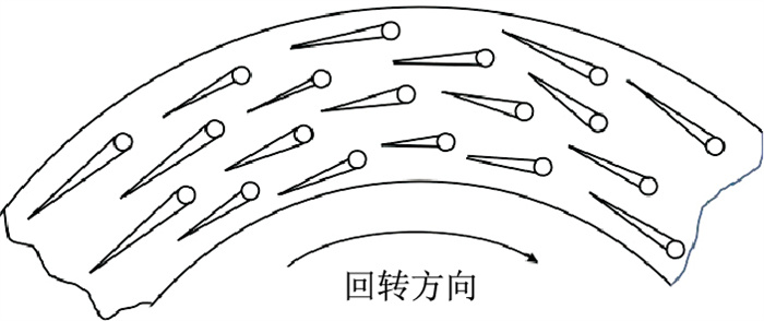
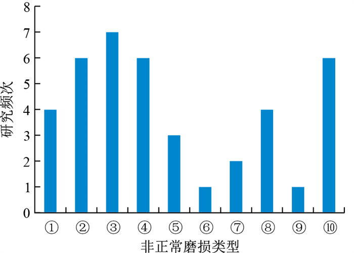
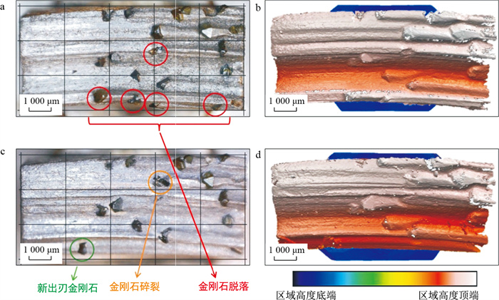
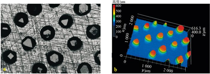
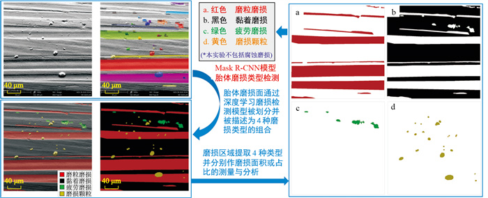
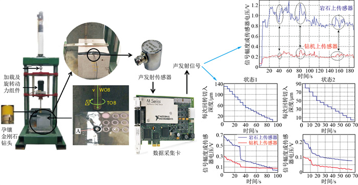
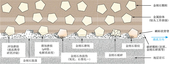
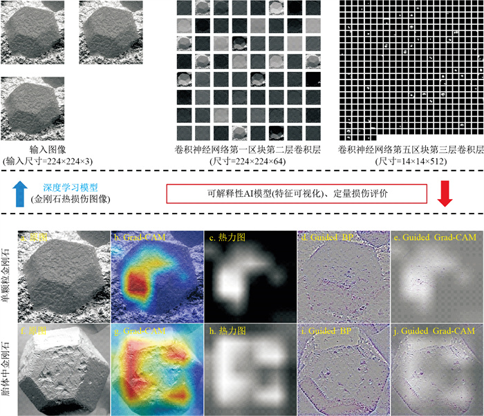
Impregnated diamond bits (IDBs) have been widely used in various hard rock drilling activities, especially deep drilling. Drilling process with IDBs relies on diamond edge wrapped by metal matrices to break the rock formation, which means the wear pattern of the diamond bit reflects the interaction between bits and rock, as well as the existence form of broken particles, which directly determine the drilling efficiency and service life of the drilling tools. But up to now there have not been so much in-depth study on its wear mechanism and analysing method in geological drilling.

Progress and Analysis

Therefore, this paper reviews the research literature on IDBs wear in the field of geological drilling, summarizes the abnormal bit wear problem according to engineering project experineces and industrial standards. Firstly, based on the experiences of geological drilling activities and industry standards, different types of abnormal bit wear of drill bits were summarized. Then, the evaluation methods of drill bit wear were introduced from the aspects of wear images and drilling signals. The wear mechanism and influencing factors of the drill bit in the drilling process were sorted out from three aspects: The overall drill bit, diamond, and metal matrix. In addition, mainstream methods of controlling drill bit wear performance were listed, and the research progress of wear analysis equations was introduced, besides, how machine learning methods can assist in the study of drill bit wear was discussed.

Conclusion and Prospect

Thus, IDBs have great potentials in deep hard rock drilling, and their wear performance is the key influnencing the whole drilling activity. To this end, research directions such as artificial intelligence assisting data analysis, microscale computational simulation, additive manufacturing, and material processing modification were analyzed and discussed, aiming to explore advanced methods for monitoring, analyzing, and regulating the wear of diamond drill bits, so as to meet the needs of remote monitoring and controlling in drilling activities such as geological deep drilling and extraterrestrial drilling.

Nonlinear degradation of stability of Q2 loess slopes in northern Shaanxi considering rainfall conditions
ZHOU Shaowei, BIAN Xiaowei, LI Weibo, MA Yuanyuan, LI Fei
2024, 43(3): 218-226. doi: 10.19509/j.cnki.dzkq.tb20230432
Abstract:
Objective

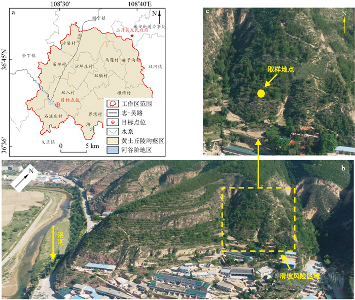
Rainfall disasters are one of the most common disasters on loess slopes in northern Shaanxi, and revealing the effects of rainfall on loess slope stability is beneficial for preventing and controlling such disasters.

Methods

This research studied the mechanical properties of Q2 loess in northern Shaanxi under rainfall conditions through a series of tests. Combined with numerical simulation technology, the influence of these changes on the stability of loess slopes in northern Shaanxi was analyzed.Firstly, the drying-wetting cycles test (cyclic path and the number of cycles) was designed to simulate rainfall conditions (such as intensity, frequency, etc.).Secondly, a triaxial shear test was performed to obtain the variation law of the mechanical properties of the Q2 loess in northern Shaanxi.Finally, taking a loess slope in northern Shaanxi region as an example, finite element calculations were carried out, by which the change characteristics of the slope safety coefficients and plasticity zones under different rainfall conditions were analyzed.

Results

The results show that (1) the shear strength of Q2 loess after the action of drying-wetting cycles has nonlinear deterioration characteristics. When the number of drying-wetting cycles exceeds a specific range, the marginal effect of the deterioration of the physical and mechanical property parameters of loess is weakened and tends to stabilize. (2) The stability of loess slopes decreases under the effect of rainfall, and it decreases with the increase of rainfall frequency or intensity. (3) The plastic zone of Q2 loess slopes in northern Shaanxi increases with the continuous deterioration of the mechanical properties of the Q2 loess, which reveals a nonlinear characteristic of the influence of rainfall on the stability of the loess slopes.

Conclusion

The research results can provide a reference for preventing rainfall-induced landslide.

Deformation evolution law and early warning criterion of Xinhua landslide
LI Yu, CHEN Mingliang, HUANG Huibao, JIANG Nan, LÜ Pengfei, ZHOU Jiawen
2024, 43(3): 227-239. doi: 10.19509/j.cnki.dzkq.tb20230306
Abstract:
Objective

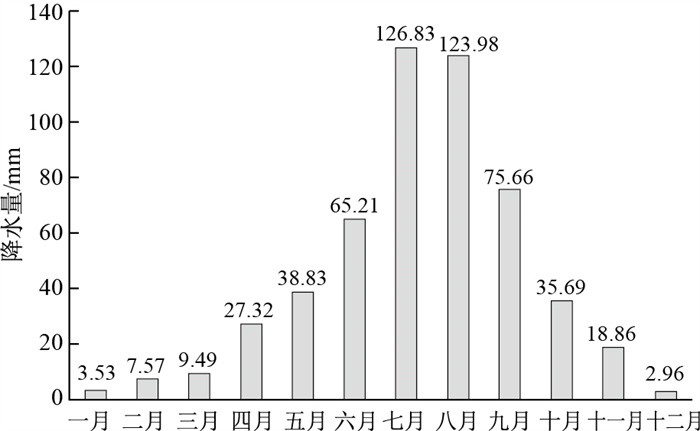
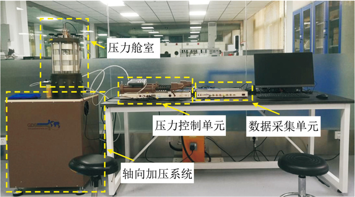
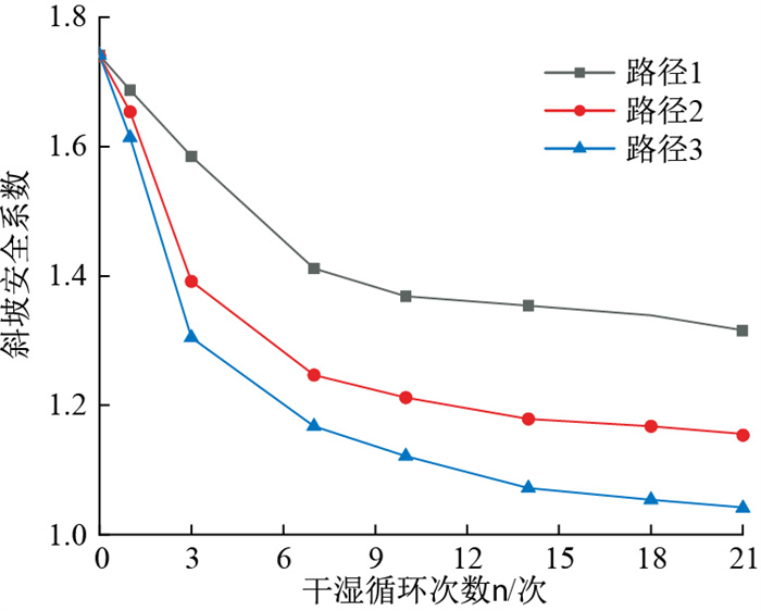
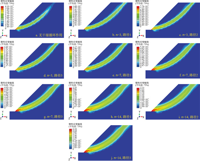
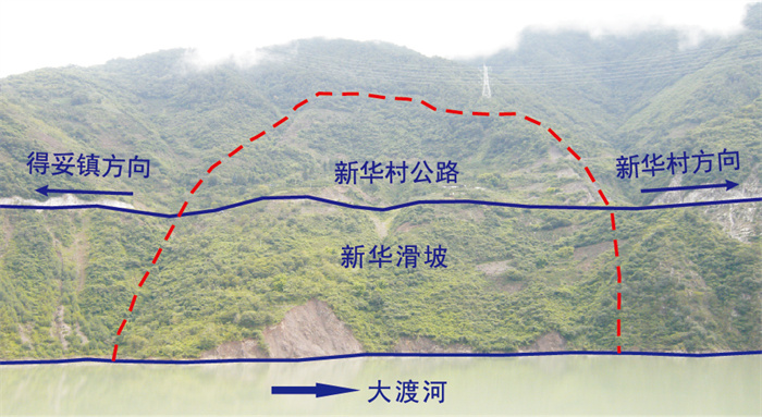
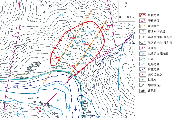
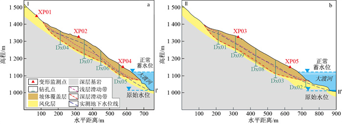
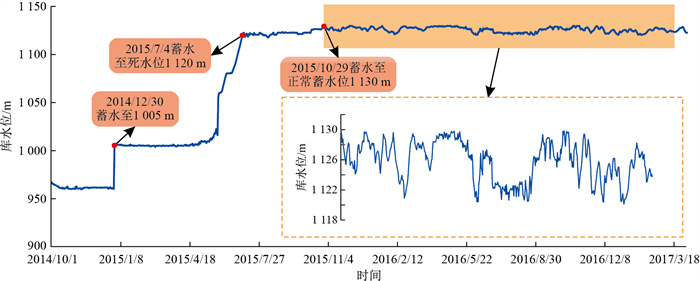
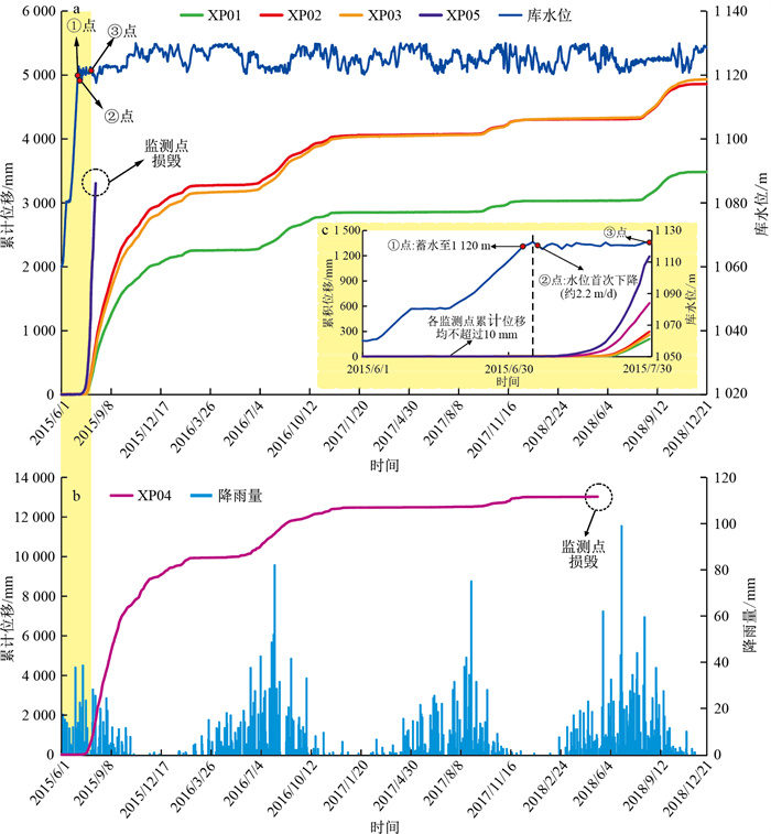
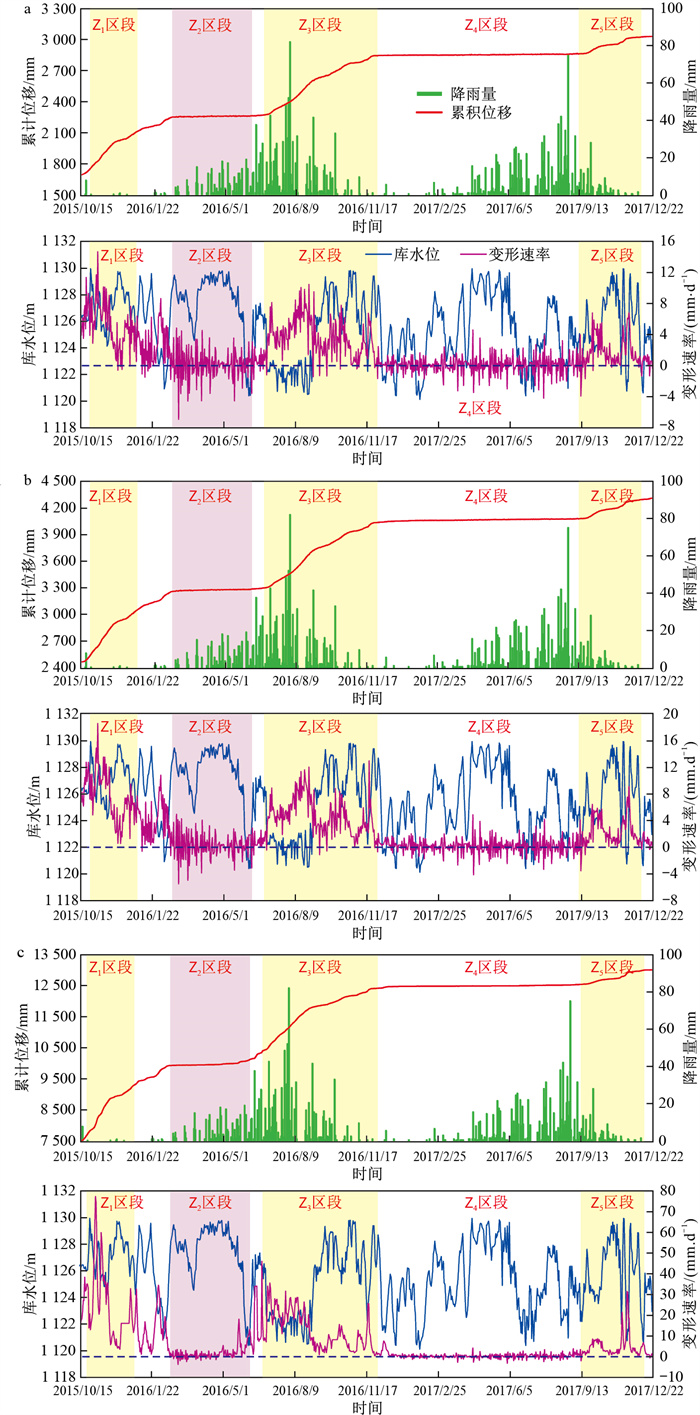
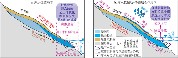
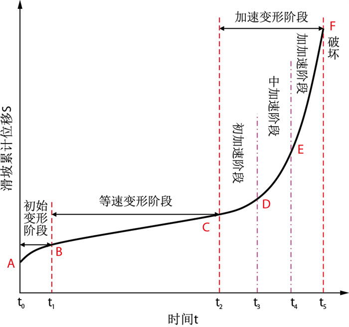
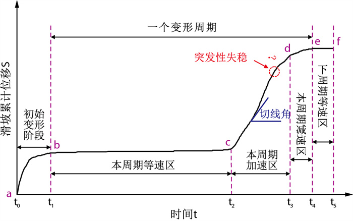
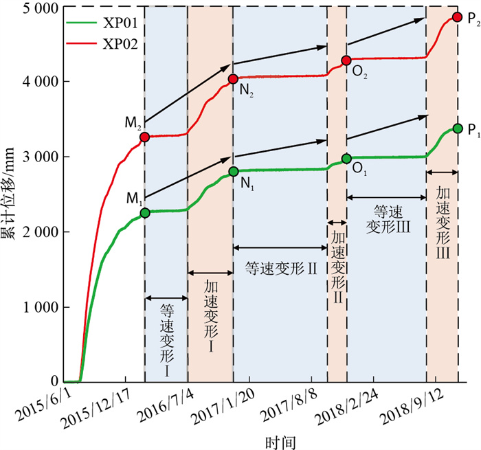
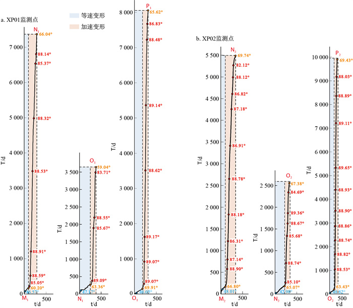
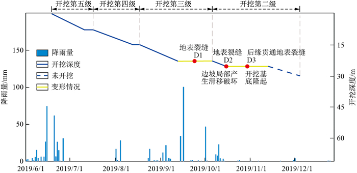
To reveal the deformation evolution of the Xinhua landslide in Luding County, Sichuan Province under the comprehensive effects of reservoir impoundment, reservoir water level fluctuations and seasonal rainfall, and to explore the progressive cumulative effect of the strength degradation of the landslide rock and soil mass under the coupling of multiple factors.

Methods

In this paper, based on a field investigation and multisource long sequence monitoring data analysis of the Xinhua landslide in the reservoir area of the hydropower project, combined with the three-stage evolution characteristics of the landslide cumulative deformation-time (S-t) curve and the measured S-t curve of the Xinhua landslide, the evolution stages of the three-step deformation cycles of the Xinhua landslide are identified and divided. At the same time, the improved tangent angle method is used for calculation and analysis, and a quantitative classification standard for Xinhua landslide classification early warning based on the improved displacement tangent angle early warning threshold is constructed.

Results

The results show that the short-term large increase of water level during the initial impoundment period, the rapid decrease of water level during the reservoir operation period and the influence of seasonal heavy rainfall are the main factors to accelerate the deformation of the Xinhua landslide.

Conclusion

According to the analysis and discussion, the improved displacement tangent angle early warning threshold can provide guidance for identifying the current stability state and potential risks of the Xinhua landslide to a certain extent, but multiple early warning indicators should still be considered, and the signs of macroscopic deformation and failure of landslides should be integrated for judgement.

Failure probability simulation of passive protection net for collapses and rockfalls in typical karst area
LU Yancheng, LI Jun, LIANG Feng, SHI Wenbing, WANG Junyi
2024, 43(3): 240-250. doi: 10.19509/j.cnki.dzkq.tb20230552
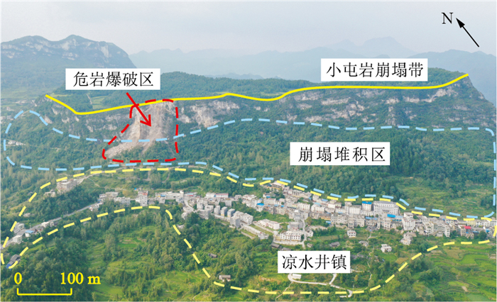
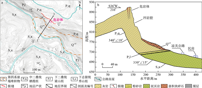
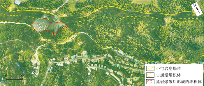
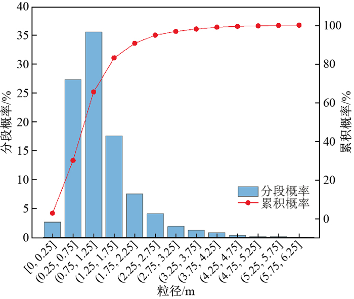
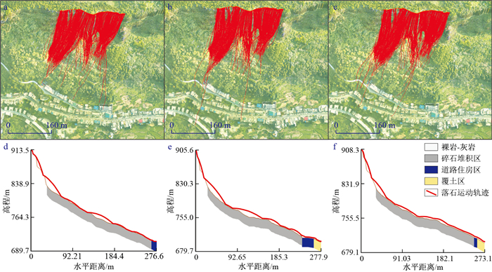
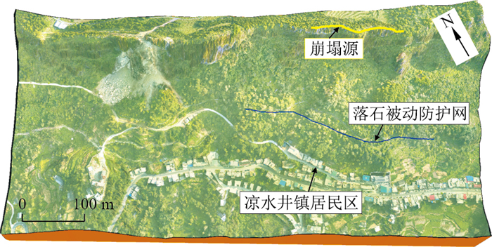
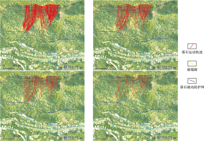
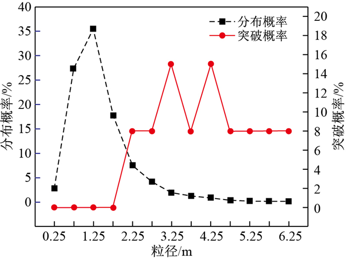
Abstract:
<p>Guizhou Province is located in Southwest of China, with many mountains and hills, and is a typical karst topography and geomorphology area with frequent geological disasters such as collapses and landslides. The existing dangerous rock mass in the Xiaotunyan collapse zone in Sinan County has large range and volume, and fissures, concave cavities, and solution caves have developed.</p></sec><sec><title>Objective

In order to study the failure probability of passive protection nets for rockfalls in typical karst areas.

Methods

A three-dimensional model of the collapse zone through high-precision realistic modeling technology was constructed, by which the movement process of collapsed falling rocks was simulated. According to the results of the field investigation, aerial photography of the unmanned aerial vehicle and numerical simulation, an appropriate rockfall location layout for the passive protection net was selected. And based on the identification of the rockfall particle size, the different rockfall particle sizes were selected to simulate the interception effect of the passive protection net, then the failure probability of the passive protective net can be calculated.

Results

The results show that the rockfall breakthrough rates of 13 particle sizes vary: the interception effect of small to medium sized falling rocks with particle sizes ranging from 0.25 m to 2.25 m is effective, but the interception rate of passive protection net cannot reach 100%. When the particle size is larger than 2.25 m, the passive protection net fails, that is the upper limit of the design of the passive protection net under the Xiaotunyan collapse zone is the 2.25 m particle size of rockfall. According to the calculation, the failure probability of all rockfall particle sizes intercepted by the passive protection net is less than 5%, which is within the acceptable scope.

Conclusion

The research results provide a reference for rockfall protection measures in the Xiaotunyan collapse zone and are of great significance for the protection of life and property safety for people in karst mountainous areas.

Susceptibility evaluation of Wenchuan coseismic landslides by gradient boosting decision tree and random forest based on optimal negative sample sampling strategies
GUO Yanhao, DOU Jie, XIANG Zilin, MA Hao, DONG Aonan, LUO Wanqi
2024, 43(3): 251-265. doi: 10.19509/j.cnki.dzkq.tb20230037
Abstract:
Objective

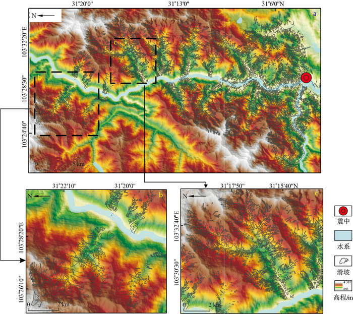
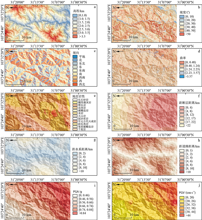
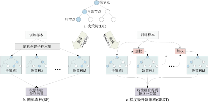
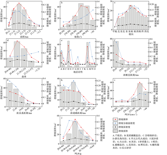
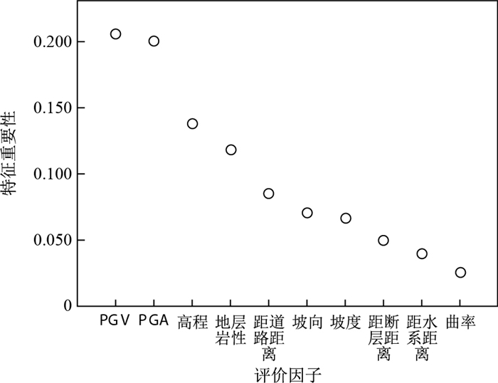
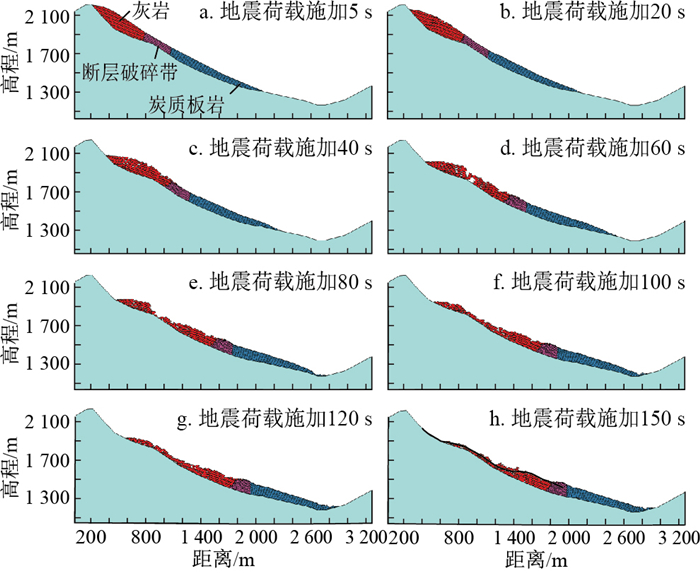
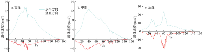
Strong earthquake-induced landslides are characterized by large number, wide distribution and large scale, and seriously threaten people's lives and property. Landslide susceptibility mapping (LSM) can quickly predict the spatial distribution of prone areas, which is highly important for reducing the risk of post-earthquake disasters. However, in the studies of coseismic landslide LSMs, how to select negative landslide samples and integrate machine learning models to improve the evaluation accuracy still needs further investigation.

Methods

In this study, the landslides induced by the Wenchuan earthquake in mountainous areas are selected as a case study. First, 10 landslide influencing factors, such as topography, geological environment, and seismic parameters, are selected to analyse the spatial distribution of landslides. Then, collinearity analysis is used to test data redundancy, nonnegative sample points from the sampling strategies are randomly selected in the extremely low susceptibility regions by the frequency ratio (FR) method. Finally, gradient boosting decision tree (GBDT), random forest (RF), and their optimal models are used to predict coseismic landslide susceptibility, conduct a comparative study of the models and carry out an accuracy assessment.

Results

The results show that ① the spatial distribution of landslides is controlled by multiple factors, and ② the accuracy of the models is FR-RF(AUC=0.943)>FR-GBDT(AUC=0.926)>RF(AUC=0.901)>GBDT(AUC=0.856). ③ Selecting negative landslide samples in low susceptibility areas could significantly improve the accuracy of LSMs.

Conclusion

The research results can provide a reference for selecting negative landslide samples and constructing evaluation models, as well as for providing theoretical support for post-earthquake disaster prevention and mitigation.

Formation and evolution mechanism of the ancient landslide and stability evaluation of the accumulation body in Jiangdingya, Zhouqu County, Guansu Province
LIU Tao, ZHANG Ming, WANG Lichao, YANG Long, YIN Baoguo
2024, 43(3): 266-278. doi: 10.19509/j.cnki.dzkq.tb20230076
Abstract:
Objective

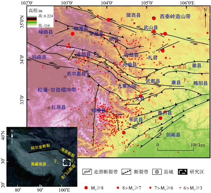
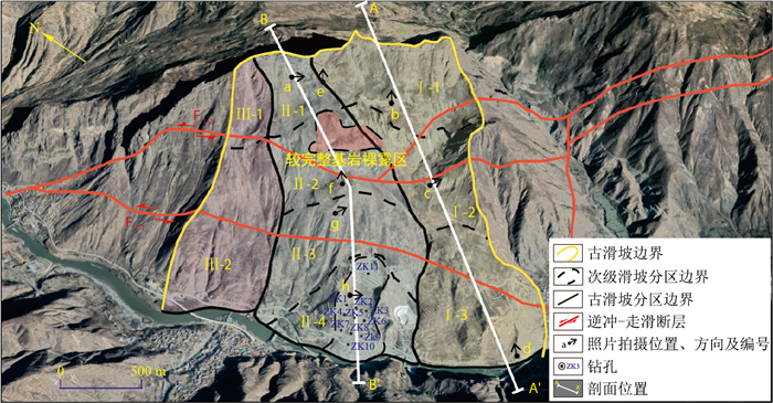
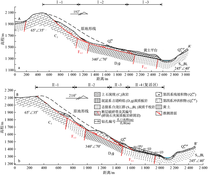
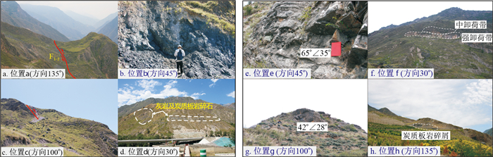
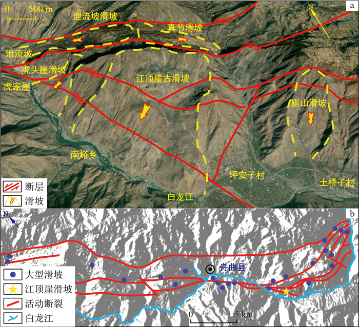
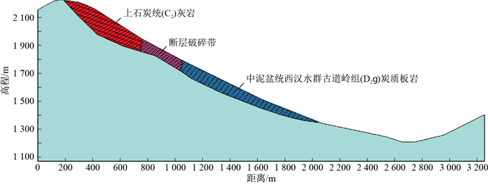
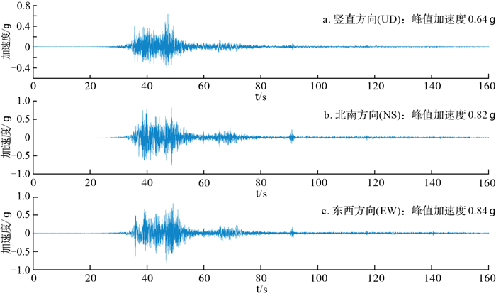
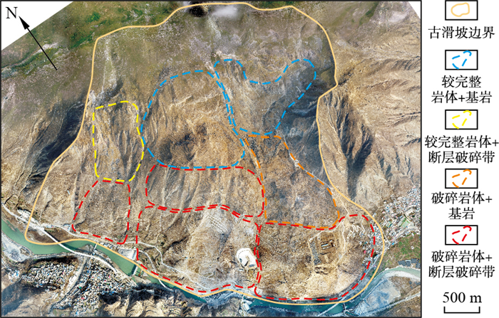
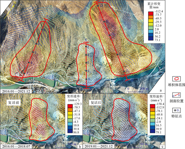
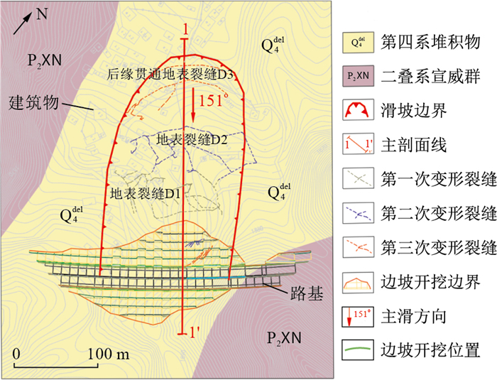
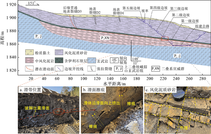
The resurrections of ancient landslide deposits are one of the primary geological hazards in the Qinghai-Tibet Plateau and surrounding areas of China and pose significant safety threats to major transportation and water conservancy projects under construction in western China. Therefore, it is crucial to investigate the formation and evolution mechanism of ancient landslides and evaluate the stability of their deposits. This research can provide theoretical support for the early recognition and prevention of the resurrection of ancient landslide deposits.

Methods

The ancient landslide deposits in Jiangdingya, Zhouqu County, Gansu Province, have experienced local resurrection several times in the past decade, creating severe threats to the lives and property of local people by blocking the Bailong River. To determine the morphology and structural characteristics of the ancient Jiangdingya landslide deposits, this study utilized field investigations and unmanned aerial vehicle (UAV) tilt photography. Based on this, the evolution mechanism and dynamic process of the landslide were analysed, and the stability of the deposits was qualitatively evaluated using InSAR deformation data.

Results

The results show that the ancient landslide at Jiangdingya is a typical large-scale earthquake landslide, with its sliding body located in a downslope position in three directions, forming a multilevel stepped deposit shape. The dynamic process of an ancient landslide under seismic loads can be divided into several stages, including vibration and cracking in the upper-middle part, shearing and landslide initiation in the front edge locking segment, tearing and landslide acceleration in the rear edge, obstruction and landslide deceleration in the front edge, and stabilization.

Conclusion

Due to the overall downwards movement of the ancient landslide under seismic loads, there are a large number of intact rock masses in the upper deposits, which are relatively stable. However, the middle and lower deposits are mostly composed of weak structures such as fault fracture zones and fragmented rock masses, which have poor stability and are highly likely to resurrect in the future. This study provides important insights into the formation and evolution of ancient landslides and the evaluation of their stability, which can help prevent future landslides and protect local communities.

Strength characteristics of the sliding zone soil of bedding deep cutting slopes and early warning analysis of the reserved thickness of the base
GAO Feng, CHEN Aiyun, XU Fangdang, YANG Liang, WANG Yang
2024, 43(3): 279-288. doi: 10.19509/j.cnki.dzkq.tb20220628
Abstract:
Objective

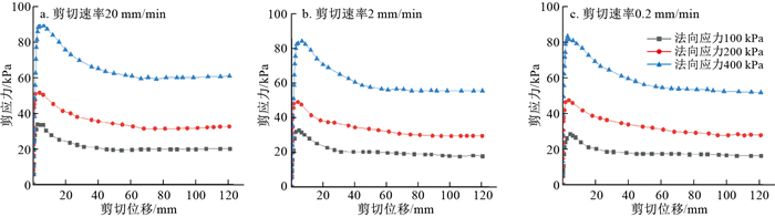
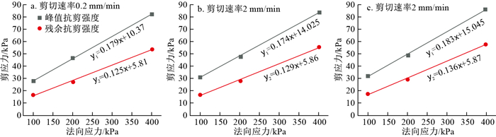
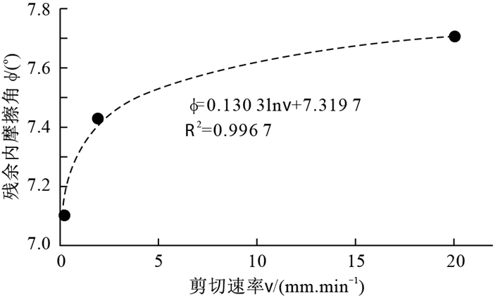
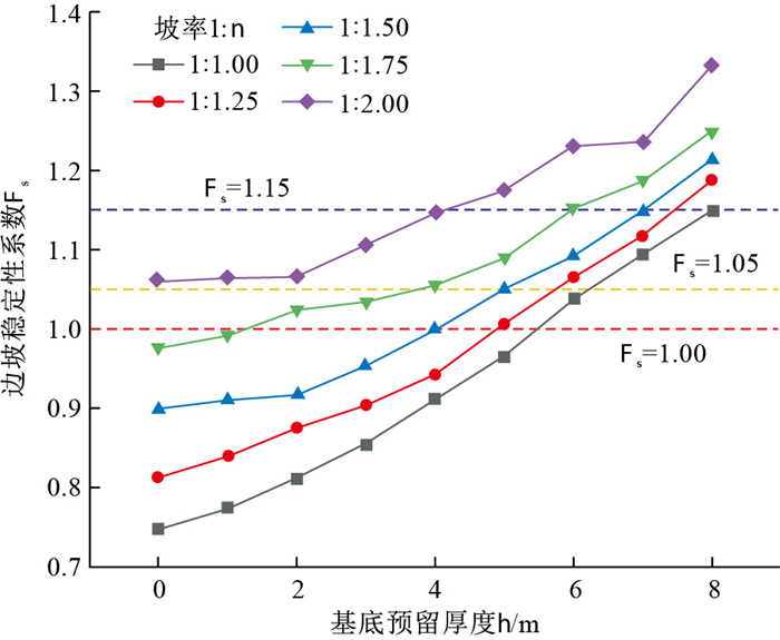
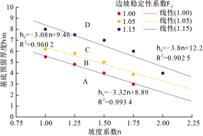
Bedding deep cutting slopes containing weak interlayers are commonly found in slope engineering, whose stability is influenced by two key factors: The strength of the sliding zone soil and the reserved thickness of the base (the distance from the base of an excavated slope to the weak interlayer).

Methods

In this research, taking the K42 cutting slope of the Yang-Xuan Expressway as an example, the evolution process of slope deformation was analyzed, especially the characteristics of basal heave deformation. The properties of the deep sliding zone soil in the slope were revealed by ring shear tests, which are suitable for studying the shear strength of soil that has experienced large shear displacements. Moreover, the residual strength parameters of the saturated sliding zone soil were applied to analyze the reserved thickness of the base.

Results

The results show that sliding zone soils exhibit obvious strain softening characteristics, which become more evident as the normal stress decreases. As the soil shear strength transitions from peak strength to residual strength, both the cohesion force and internal friction angle decrease, with the cohesion force decreasing to a greater extent than the internal friction angle. The residual cohesion force of sliding zone soil varies slightly with the shear rate, while the relationship between the residual internal friction angle and shear rate varies as a logarithmic function. When the shear rate is less than 2 mm/min, the residual shear strength parameter of sliding zone soil is more sensitive to the shear rate and vice versa.

Conclusion

Furthermore, according to the regression equations of the critical states of slope stability, the reserved thickness of the base under different slope rates was divided into four zones: A (extremely unstable zone), B (unstable zone), C (basically stable zone) and D (stable zone), and based on this, the criterion and early warning model of the reserved thickness of the base for slope excavation were established.

Numerical simulation method for reactive solute transport based on micro-continuum medium model
ZHANG Qian, DONG Yanhui
2024, 43(3): 289-300. doi: 10.19509/j.cnki.dzkq.tb20230081
Abstract:
Significance

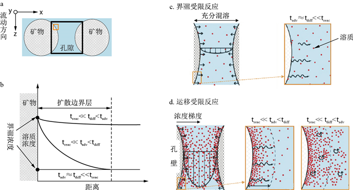
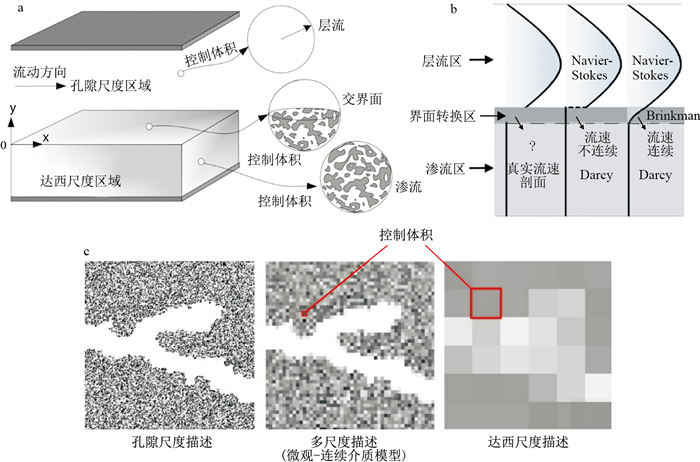
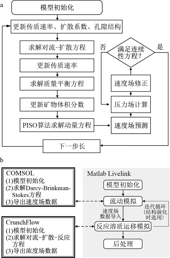
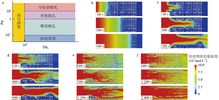
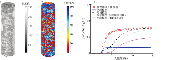
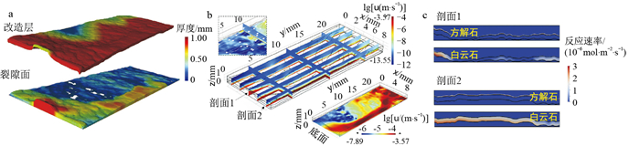
Fluid-solid interactions in reactive solute transport processes, governed by physical and chemical heterogeneities, dictate the evolution of subsurface geomaterials, resulting in nonlinear behaviours and multiscale features. It has become increasingly evident that examining the feedback between microscopic features and macroscopic behaviours in geomaterials is critical in various academic and industrial applications.

Progress

In this study, we introduce the concept and framework, mathematical and numerical models of the micro-continuum medium, as well as multiscale solvers and applications. Challenges in co-designed simulations and experiments are also discussed.

Conclusion and Prospects

Despite offering valuable insights into reactive transport processes, continuum-scale modelling or pore-scale modelling suffers from a gap between theoretical understanding and computational prediction. Recently, an alternative conceptualization of the multiscale problem involves the implementation of the Darcy-Brinkman-Stokes (DBS) equation in a single micro-continuum domain to identify reactive transport patterns across spatial scales under changing flow regimes. As fluid-solid interfaces cannot be explicitly resolved as in pore-scale models, the micro-continuum medium approach has the advantage of accommodating complex geometries or evolving interfaces without increasing computational costs.

Application of MODFLOW-CFPv2 model in karst tunnel water inrush and its impact on groundwater environment: Example of the Mengkuanggou karst water system in Heqing County, Yunnan Province
XIAO Jing, WAN Junwei, CHENG Jianmei, LI Zhongxia, YU Hang, LI Jinghong, YUAN Shuai
2024, 43(3): 301-310. doi: 10.19509/j.cnki.dzkq.tb20230072
Abstract:
Objective

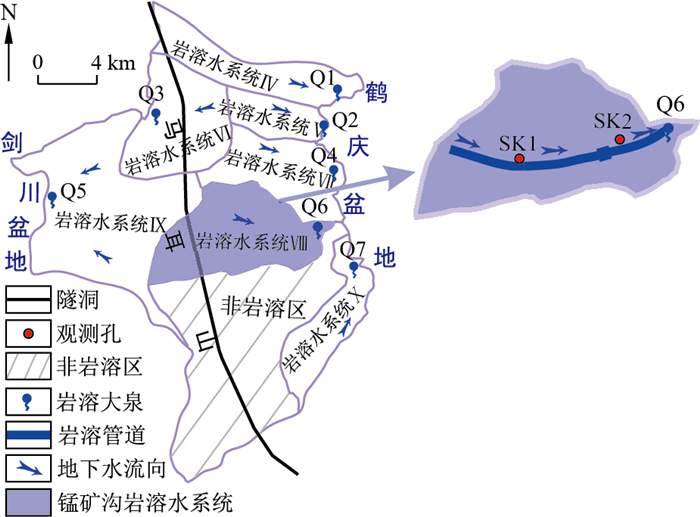
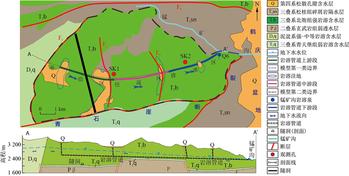
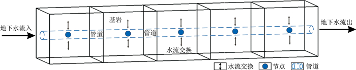
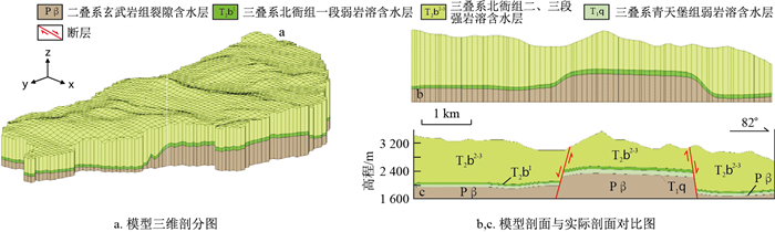
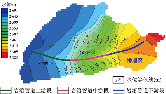
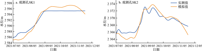
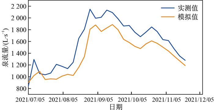
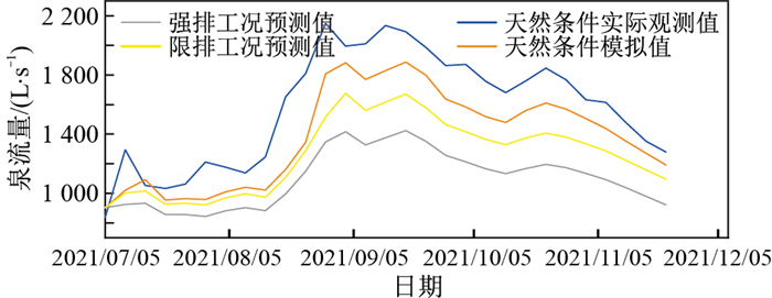
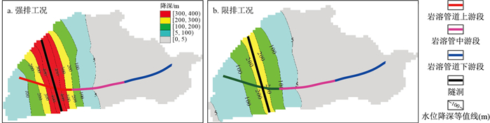
In the central Yunnan region, the geological structure is complex and karst formations are prevalent. Sudden water gushing and attenuation of spring flow are among the most difficult problems in tunnel construction. The Mengkuanggou karst water system exhibits a high degree of karst conduitization, with significant differences between karst fissures and karst conduits.

Methods

This study employs the MODFLOW-CFPv2 dual medium numerical model to simulate the karst water system of Mengkuanggou, providing a detailed description of karst pipeline and diversion tunnel to understand the influence of tunnel construction on groundwater flow and spring flow.

Results

The results show that (1) The MODFLOW-CFPv2 model can describe the complex geological structure of karst areas, and simulate the dynamic characteristics of the groundwater level and the response characteristics of karst spring flow in the study area. (2) Under the condition of strong discharge, the water inflow per unit length of the tunnel is 164 m3/d·m, with a stable water inflow of 69 m3/d·m, while the Mengkuanggou karst spring flow shows a significant downwards trend. During the simulation period, the average spring flow decreased from 1 578 L/s under natural conditions to 1 098 L/s, an overall decrease of 30.4%, and the peak flow rate decreased from 2 133 L/s to 1 375 L/s, a decrease of 35.5%. The construction of strong discharge conditions will have a significant impact on tunnel construction and the groundwater environment. Under the condition of limited discharge, the maximum water inflow of the tunnel is 39 m3/d·m, and the stable water inflow is 24 m3/d·m. The water inflow of the tunnel is significantly reduced, and the downwards trend of the karst spring flow in Mengkuanggou is also improved to a certain extent. During the simulation period, the average spring flow is reduced to 1 284 L/s, a reduction of 18.6%, and the peak flow is reduced to 1 617 L/s, a decrease of 22.1%.

Conclusion

The MODFLOW-CFPv2 dual-medium model used in this study accurately describes highly heterogeneous karst water systems with pipelines, karst caves and fissures in karst areas. It can be used to quantitatively evaluate the karst water of Mengkuanggou during Xianglushan Tunnel construction.

Distribution, sources and transport of HCHs and DDTs in the Yuquandong spring system from Zigui County, Hubei Province
YANG Xiuwen, WEI Zhiying, YI Jiapei, LI Wenxing, JING Yiming, QIN Chaojie, XIONG Junwu, LIU Wei, ZHOU Hong, QI Shihua, CHEN Wei
2024, 43(3): 311-322. doi: 10.19509/j.cnki.dzkq.tb20230466
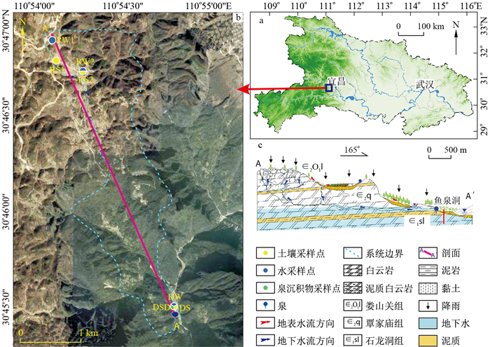
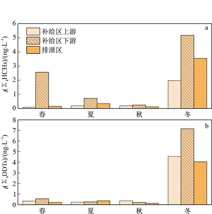
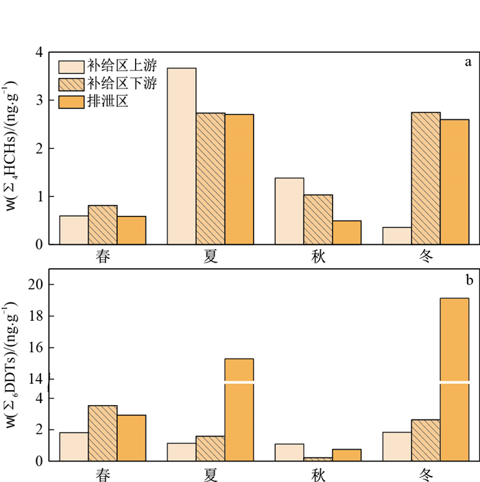
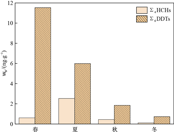
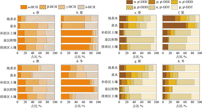
Abstract:
<p>The special topography of karst areas allows organochlorine pesticides (OCPs) from the surface environment to easily infiltrate the underground environment, posing a threat to groundwater security.</p></sec><sec><title>Methods

In this study, a gas chromatography-electron capture detector (GC-ECD) was used to detect two typical OCPs, namely, HCHs and DDTs, in the Yuquandong spring system in Zigui, Hubei.

Objective

This study investigated spatial and temporal distribution characteristics, sources and transport of HCHs and DDTs.

Results

The results showed that the mass concentrations of HCHs in the water ranged from 0.09 to 5.17 ng/L, and the mass fractions of HCHs in the soils and spring sedimentsranged from 0.36 to 3.67, 0.11 to 2.53 ng/g, respectively, mass concentrations of DDTs in the water ranged from 0.13 to 7.16 ng/L, and the mass fractions of DDTs in the soils and spring sedimentsranged from 0.22 to 19.13, 0.73 to 11.53 ng/g, indicating that the pollution was dominated by DDTs. The highest mass concentrations of HCHs and DDTs in water were observed in winter; the highest mass fractions of HCHs and DDTs in the soils were observed in summer and winter, respectively; and the mass fractions of HCHs and DDTs in the spring sediments peaked in summer and spring, respectively. Characteristic ratios showed that HCHs in water, soils and spring sediments mainly originated from lindane usage, DDTs in water mainly originated from historical residues, and DDTs in the soils and spring sediments mainly originated from recent usage. Correlation analysis indicated that HCHs and DDTs could be transported from the surface water and the soils in the recharge area to the spring water and spring sediments in the discharge area, respectively. The rapid transport of HCHs and DDTs across multiple media confirmed groundwater vulnerability in karst areas.

Conclusion

The study can provide a reference for the protection of karst groundwater resources and the environment.

Interpretation and evaluation methods of image logs and their geological applications
LAI Jin, XIAO Lu, BAI Tianyu, FAN Qixuan, HUANG Yuyue, LI Hongbin, ZHAO Fei, WANG Guiwen
2024, 43(3): 323-340. doi: 10.19509/j.cnki.dzkq.tb20220701
Abstract:
Significance

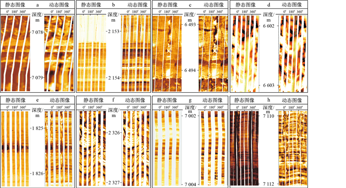
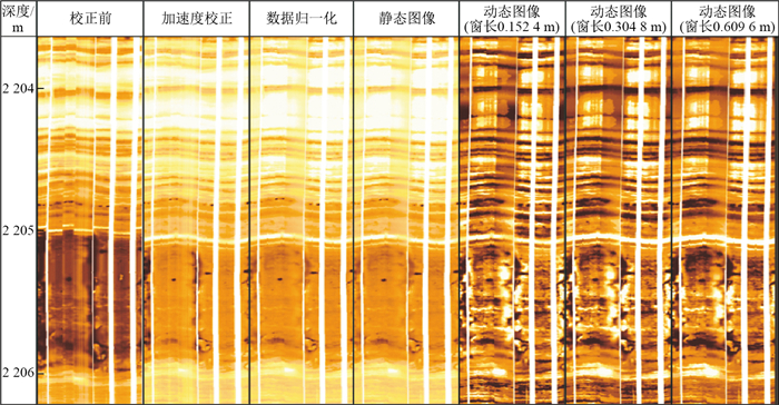
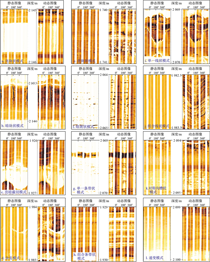
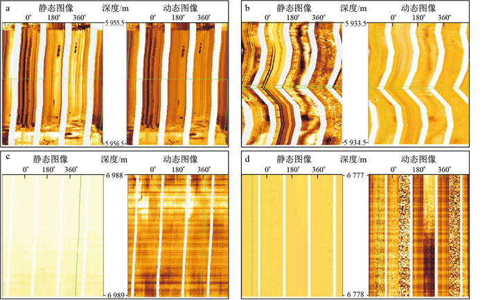
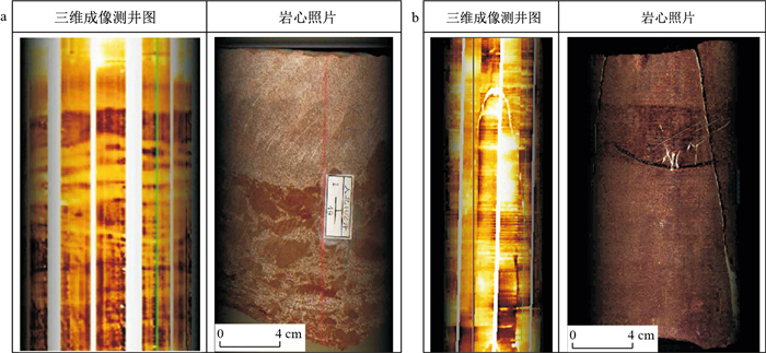
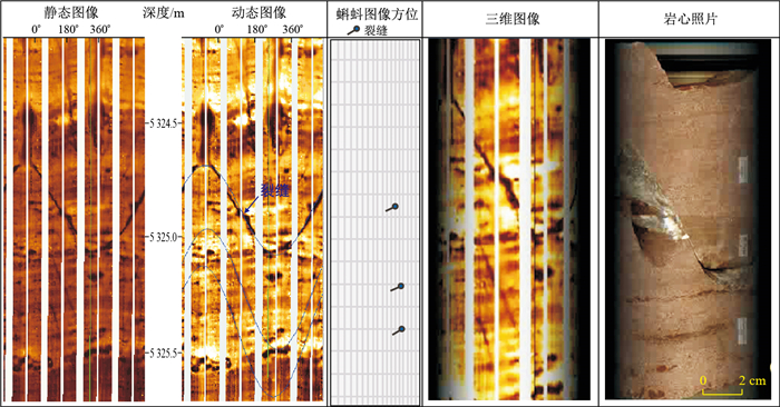
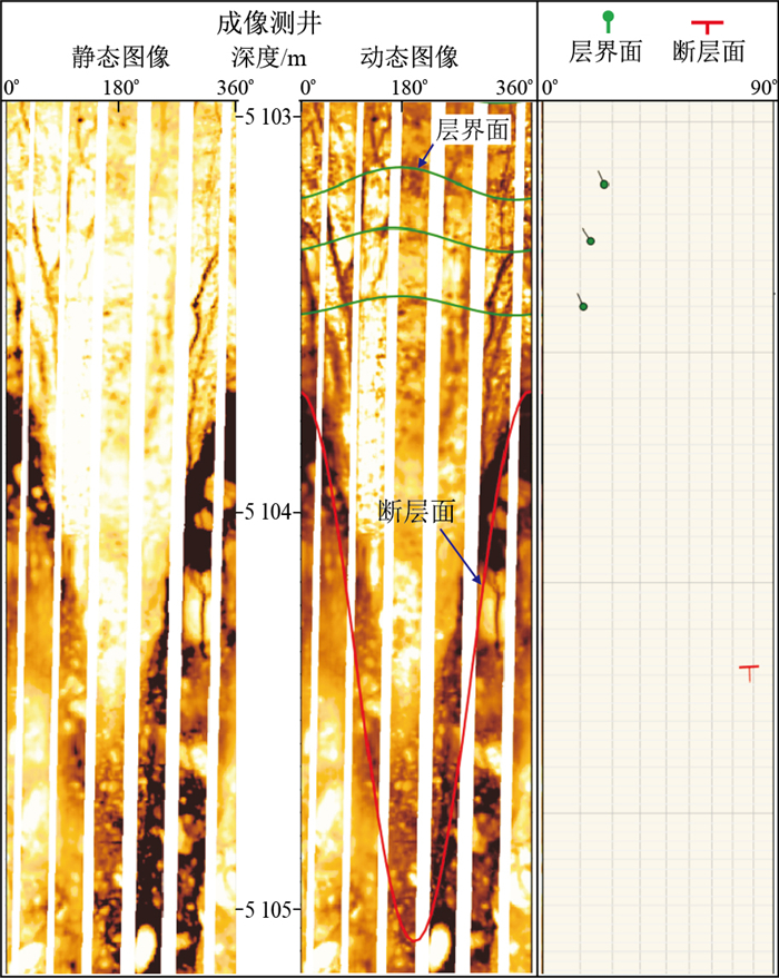
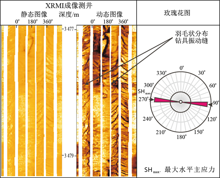
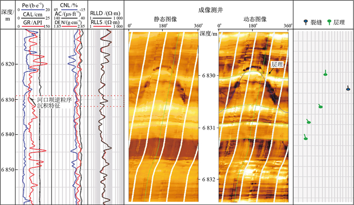
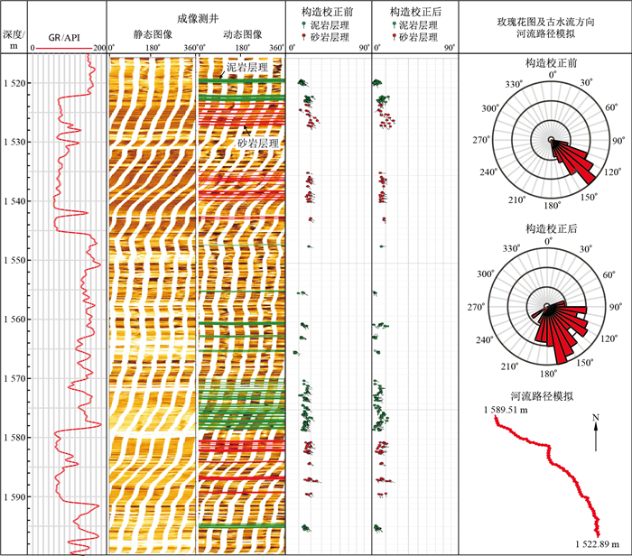
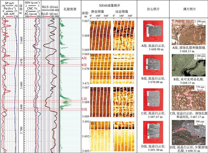
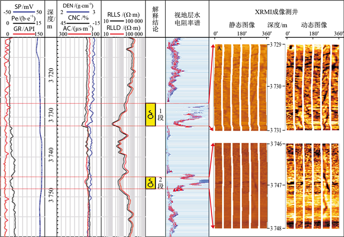
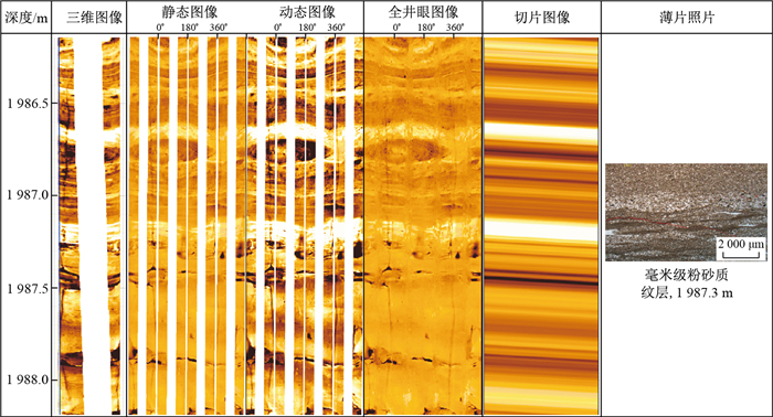
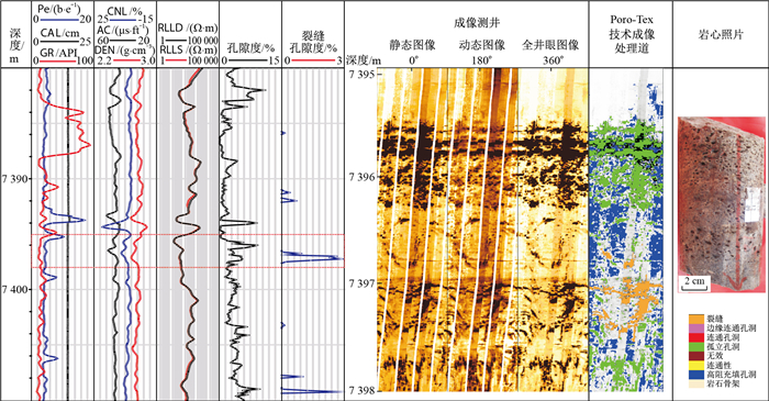
To systematically address problems related to the interpretation and evaluation of image logs and expand their application range in geology and engineering fields, firstly, the development history, data processing steps and interpretation process of image log acquisition series are reviewed, and then fine interpretation methods for image logs, constrained by "four levels" (direct interpretation of images, conventional logging constraints, core constraints and geological theory constraints), are proposed in this paper.

Progress

The image log facies models can be divided into seven categories: massive, banded, cross-stratified, spotted, convoluted, graded and symmetrical groove modes. Image logs can be used for core orientation, formation attitude acquisition, fracture evaluation, fault property analysis, in situ stress direction discrimination, sedimentary characteristic pickup, palaeocurrent direction discrimination, etc. Through the inverse calculation of Archie's formula, the image log data matrix can generate porosity spectra and apparent formation water resistivity spectra, which can be used for reservoir quality evaluation and fluid property identification, respectively. Slab images can reveal information such as sedimentary laminae, fine-grained sediment lamina textures can be identified, and high-resolution logging can be used to evaluate unconventional oil and gas reservoirs. Poro Tex image structure analysis technology can be used to identify the characteristics of reservoir spaces such as pores and fractures and to quantitatively calculate parameters such as porosity and fracture porosity. Therefore, it is widely used in comprehensive logging evaluations of highly heterogeneous carbonate reservoirs.

Conclusions and Prospects

These research results can help us to avoid misunderstandings in image logs interpretation and expand the application field of image logs.

Research on audio-frequency magnetotelluric detection capability of geothermal clay cap based on trans-dimensional Bayesian inversion
ZHU Yue, PENG Ronghua, HU Xiangyun, ZHOU Wenlong, HUANG Shuncong, LU Xing
2024, 43(3): 341-350. doi: 10.19509/j.cnki.dzkq.tb20220697
Abstract:
Objective

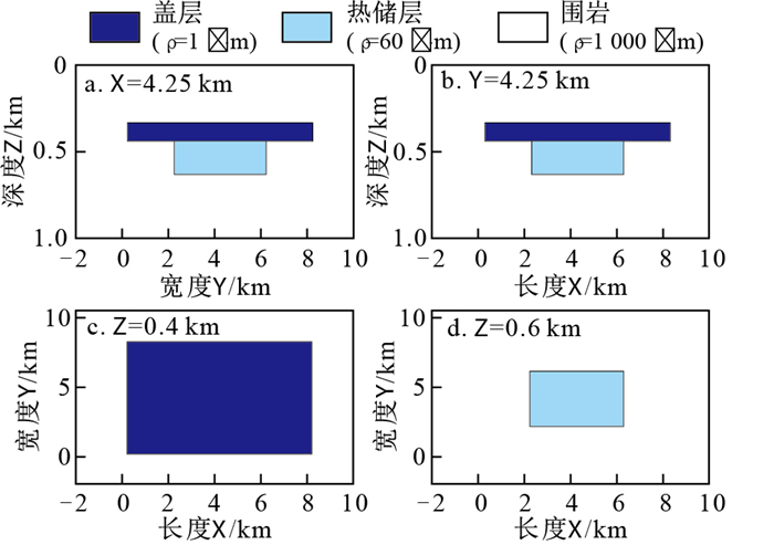
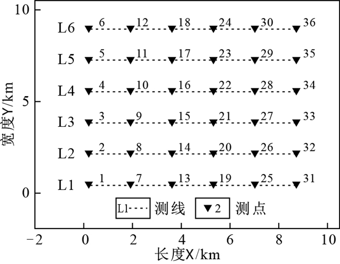
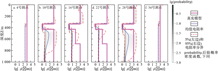
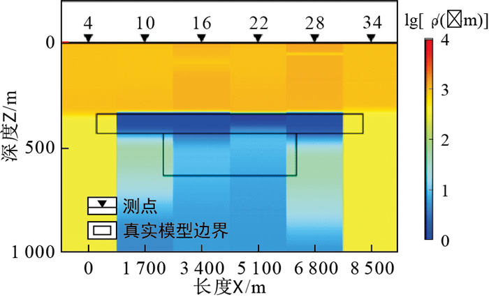
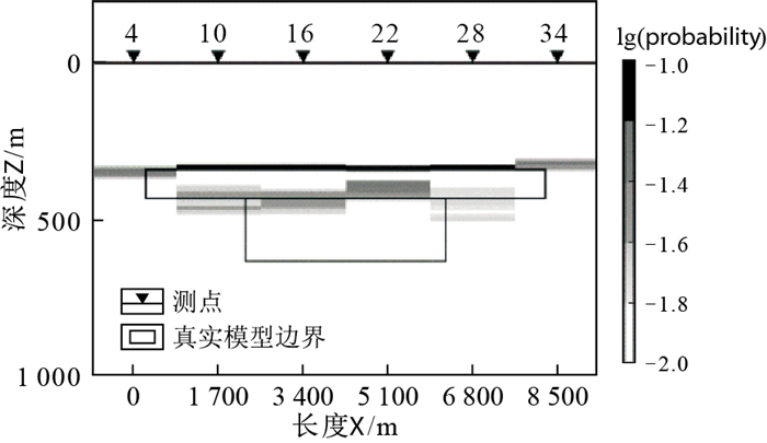
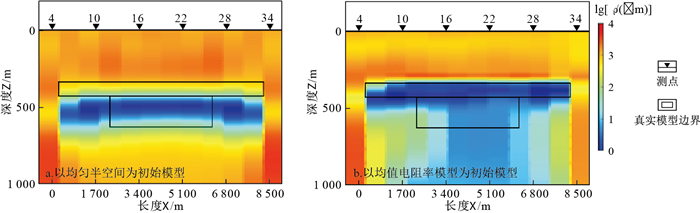
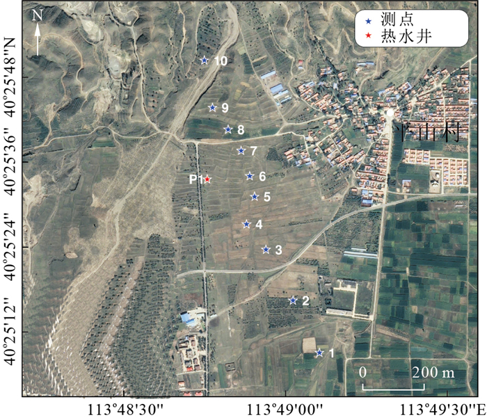
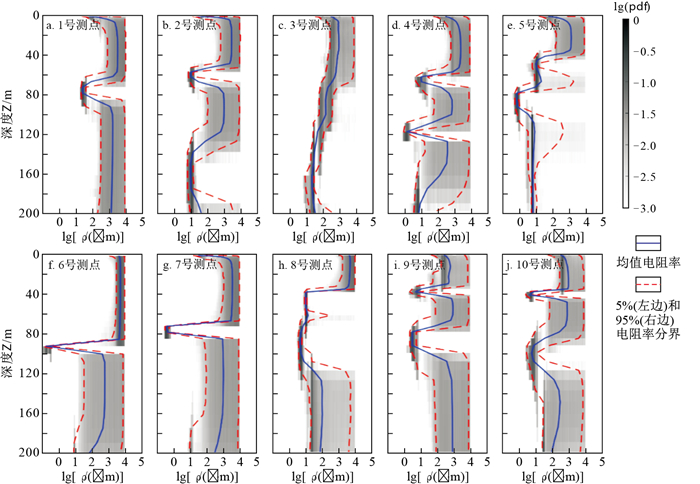
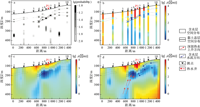
In geothermal exploration, a clay cap is a typical hydrothermal geothermal system, and its depth and distribution range can provide crucial information for delineating the scope of geothermal resources and determining the location of geothermal drilling. Clay caps are usually composed of a clay layer formed through hydrothermal reactions and are characterized by low resistance. The low-resistivity cap can be effectively imaged using the audio-frequency magnetotelluric method. To obtain uncertainty information about the distribution of clay cap layers and imaging results, this paper employs the 1D trans-dimensional Bayesian inversion method to investigate the detection capabilities of low-resistance cap layers in geothermal areas through audio electromagnetic data.

Methods

In this paper, a model test is first carried out to establish a geoelectric model of a typical geothermal system.Subsequently, a 1D trans-dimensional Bayesian algorithm is used to invert the synthetic data to obtain the uncertainty information of the subsurface electrical structure and interface position. Then, the method was applied to the processing of measured audio frequency magnetotelluric data in the Yanggao geothermal area of Shanxi Province.

Results

This method has relatively accurate identification ability for low-resistivity clay caps, and the obtained uncertainty analysis results of the upper and lower interfaces of low-resistivity caps are also relatively reliable according to numerical tests. It was found that this method has a good ability to identify shallow low-resistivity caps and can provide an uncertainty evaluation of the clay cap interface position via field data tests. The 2D inversion results of this survey line verify the reliability of the 1D inversion.

Conclusion

This method has relatively accurate imaging capabilities and uncertainty analysis capabilities for shallow geothermal clay caprocks and has strong application prospects in geothermal detection.

A method for detecting the dissemination size of metal minerals under the microscope based on deep learning
TANG Huaming, LANG Zengrui, WANG Hongming, WANG Ling, WANG Long, CAO Chong, NIE Yimiao, LIU Shuxian, HAN Xiuli
2024, 43(3): 351-358. doi: 10.19509/j.cnki.dzkq.tb20230026
Abstract:
Objective

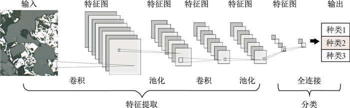
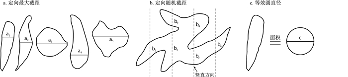
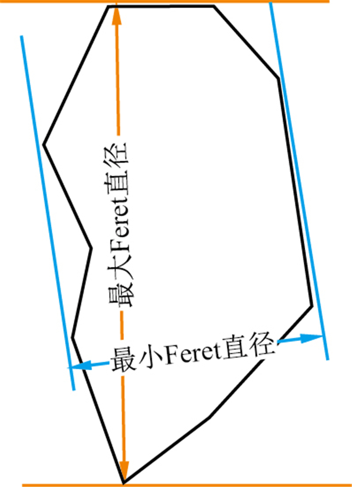
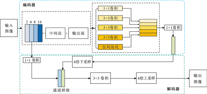
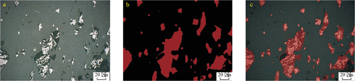
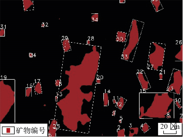
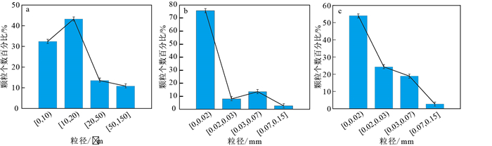
The embedded granularity of target minerals refers to their particle size and distribution in ore, which directly influences the design and effectiveness of ore beneficiation processes. Therefore, the measurement of embedded granularity of target minerals is a crucial task in process mineralogy research. In traditional process mineralogy research, the main method for observing and analysing ore samples is to use a polarized light microscopy. However, this approach generally suffers from problems such as long processing times, susceptible to subjective factors, and difficulties in achieving automation and large-scale applications. To overcome these limitations, this paper proposes a method for detecting the embedded granularity of metal minerals under the microscope based on based on deep learning.

Methods

This method takes specimens from the Shuichang magnetic ore deposit in Tangshan City, Hebei Province as the object. We take photographs under the reflected light conditions using a polarized light microscope to create a dataset, and design a mineral recognition network model based on the Deeplabv3+ network. Thereby it enables automated feature extraction and intelligent recognition of the target metal minerals. This method achieves segmentation of the target minerals by generating binary images of the desired metal minerals. Finally, the analysis and measurement of the embedded granularity of the target metal minerals are completed by combining the maximum Feret diameter.

Results

Compared with traditional manual microscopic measurement methods, the application of image measurement based on deep learning in mineral particle analysis has increased the processing speed by approximately 119.8 times and the measurement accuracy 169.5 times when measuring the same mineral particles, demonstrating its significant improvement in terms of processing efficiency and measurement accuracy.

Conclusion

The deep learning-based method for detecting the embedded granularity of metal minerals under a microscope significantly reduces the detection time and enhances the detection accuracy for mineral embedded granularity. Moreover, it eliminates the influence of subjective factors, which is of great significance for promoting the intelligent development of process mineralogy.