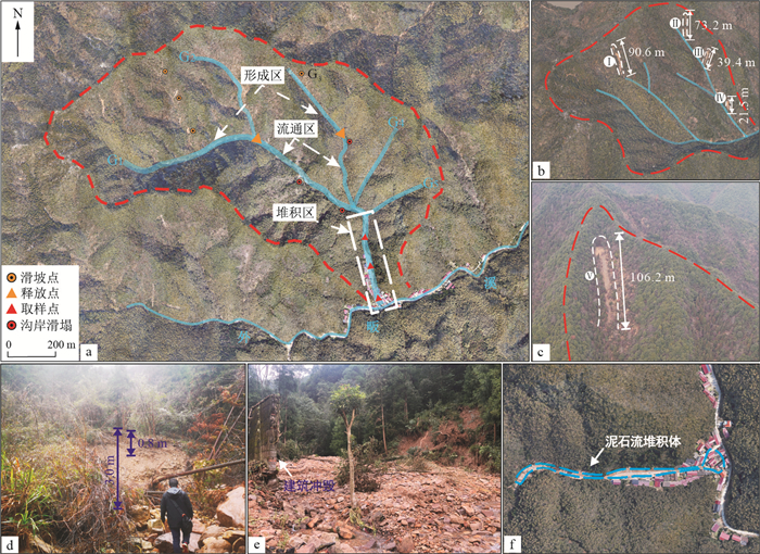
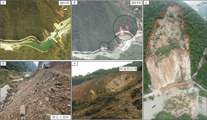
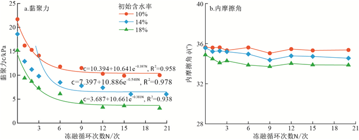
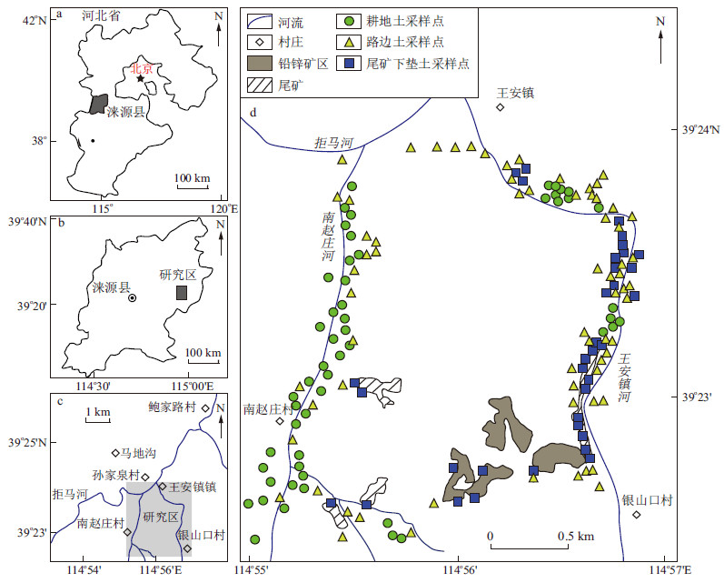
Current Issue

2024 Vol. 43, No. 2

Display Method:
Lithofacies heterogeneity and reservoir pore development characteristics of continental shale: A case study of the Dongyuemiao shale of the Ziliujing Formation in the Sichuan Basin
SHU Zhiguo, SHU Yi, CHEN Miankun, PENG Wei, LIU Haotian, XIAO Xiong
2024, 43(2): 1-15. doi: 10.19509/j.cnki.dzkq.tb20220446
Abstract:
Objective

After the exploration break through of the Well Fuye 10 in the Fuxing area of the Sichuan Basin, shale oil and gas from the Dongyuemiao section of the Jurassic Ziliujing Formation showed good exploration potential. The Dongyuemiao shale is characterized by unique shell limestone interlayers, high clay mineral content (up to 60%), various reservoir pore types, and strong vertical heterogeneity.

Methods

Taking the Well Xingye X as an example, combined with logging data, core observation, argon ion polishing scanning electron microscopy (SPE), and other technical means, the lithofacies characteristics and pore development characteristics of continental shale in the Dongyuemiao section were emphatically analysed.

Results

In this study, the principle of continental shale lithofacies division of "interlayer+mineral three-terminalelements" was established, and the continental shale of the Dongyuemiao section was vertically divided into 6 lithofacies: shell rhythmic mixed shale facies, silt shell interbedded clay shale facies, silt lithic interbedded mixed shale facies, lithic limestone facies, lithic interbedded mixed shale facies, and lithic interbedded clay shale facies. Through argon ion polishing and scanning electron microscopy (SEM), it was found that this set of continental shale mainly develops special complex organic clay pores, of which the lithic interbedded clay shale facies was the most developed type of organic pore, while the lithic limestone facies organic pores were not developed, mainly develop intragranular dissolved pores. The mercury intrusion nitrogen adsorption joint measurement results revealed that there was no significant difference in the pore size distribution of the six lithofacies shales.

Conclusion

Comprehensive analysis revealed that the interaction between organic matter and clay minerals during the diagenetic evolution process was the main factor influencing the pore development of continental shale in the Dongyuemiao section.

Characteristics and main controlling factors of the tight sandstone reservoirs around the paleo-uplift in the southern Tianshan area, Tarim Basin
XIA Yongtao, WANG Ren, YANG Hongcai, SHI Wanzhong, BAHETIYAER Ainiwaer, QIN Shuo, ZHANG Xiao, XU Zhuang
2024, 43(2): 16-27. doi: 10.19509/j.cnki.dzkq.tb20220592
Abstract:
Objective

The main controlling factors and densification genesis of sandstone reservoirs around the paleo-uplift in the southern Tianshan area of the Tarim Basin have always restricted the increase in reserves and production in this area.

Methods

By using thin section and cathode luminescence (CL) observations, physical property testing, mercury injection analysis, and other related methods, the characteristics of sandstone reservoirs in the Lower Cretaceous Baxigai and Shushanhe Formations were studied, and the main factors controlling the reservoir properties were also summarized.

Results

The study draws the following conclusions: The porosity of the target layer in the study area is mostly less than 10%, and the permeability is less than 1×10⁻³ μm2, which is a typical tight sandstone reservoir. Among them, the braided river delta sandstones exhibit the best physical properties (φ=12.3%, k=60.4×10⁻³ μm2) and pore structure, followed by the fan delta sandstones (φ=6.9%, k=1.9×10⁻³ μm2), while the lacustrine sand bar facies features the worst physical properties (φ=6.7%, k=0.34×10⁻³ μm2). The evolution of paleo-uplift controlled the differences between sedimentary facies and diagenetic processes. The sedimentary environment of braided river deltas and fan deltas has strong hydrodynamic forces, coarser particles, and weak cementation, so the porosity and permeability are high. In contrast, the lacustrine sand bar facies are far away from terrigenous input, the grains are fine, and the underwater paleo-uplift controlled the formation of carbonate cement with high contents in the diagenetic stage, which blocked the pore throat and reduced the physical properties of the sandstone reservoir.

Conclusion

These results provide a reference for petroleum exploration and development of the Lower Cretaceous successions in the southern Tianshan area.

Main controlling factors and development model of tight reservoirs in the Shihezi Formation-Shanxi Formation in the Ordos Basin: Taking the Binchang area as an example
LI Song, MA Liyuan, WANG Ruyue, DENG Jie, LI Yudong, QUAN Xiaoyuan, JIANG Rong
2024, 43(2): 28-40. doi: 10.19509/j.cnki.dzkq.tb20220468
Abstract:
Objective

Defining the distribution of sweet spots in tight reservoirs is the focus of tight oil and gas exploration.

Methods

Using core observation, thin section identification, X-ray diffraction, homogenization temperature measurements of inclusions, and conventional physical property analysis, the sedimentary characteristics, reservoir characteristics, and diagenesis of Upper Palaeozoic tight sandstones in the Binchang area, southern Ordos Basin were studied in detail.The main controlling factors of reservoir formation were identified and the development model of high-quality reservoirs was established.

Results

The results show that sedimentary facies are the basis of reservoir formation, and the core beach microfacies of the braided river delta plain have coarse grain sizes, small pore-medium-fine throat pore structures, and relatively good reservoir physical properties. The underwater distributary channel and estuary bar in front of the meandering river delta have fine grain sizes and pore throat structures of micropore-microat throat pore structure, and the reservoir's physical properties are relatively poor. Diagenesis plays an important role in controlling the development and distribution of high-quality reservoirs. Intermittent volcanic tuff is transformed into kaolinite in acidic strata and altered into chlorite sheaths in alkaline strata, which inhibits quartz overgrowth and calcite cementation and protects the reservoir space. The secondary enlargement of quartz is mainly caused by the leaching of SiO2 from mudstone to sandstone.The main reasons for the cementation of calcite roof and floor are the filling of feldspar and the dissolution of cuttings in the middle and late stages of calcite. The microfractures formed by late tectonic transformation have no calcite cementation, which improves the physical properties of the reservoir and plays an adjusting role in the gas reservoir. There are two solution pore development zones near burial depths of 3 750 m and 3 900 m in the Binchang area. The optimal reservoir is the medium-coarse-grained sandstone rich in chlorite mantle formed by the transformation of volcanic tuffaceous matter in the dissolution pore development zone. The sub-optimal reservoir is mainly distributed in the middle and lower parts of the sand body with a greater single-body thickness, cyclicity and no mudstone interval in the dissolution pore development zone.This zone is composed mainly of medium-coarse-grained sandstone lacking chlorite film, calcite cementation and secondary enlargement of quartz are the lowest.

Conclusion

These research results further increase the understanding of the genesis of the development of high-quality tight sandstone reservoirs in the Upper Palaeozoic, providing important guidance for natural gas exploration and development in this area.

Micropore structure and movable fluid distribution characteristics of tight sandstone reservoirs: Taking the He 8 reservoir in the Shenmu area of the eastern Ordos Basin as an example
XIA Yulei, LAN Jianping, YAO Wei
2024, 43(2): 41-51. doi: 10.19509/j.cnki.dzkq.tb20220574
Abstract:
Objective

The complex pore throat structure of tight sandstone leads to variable distribution of movable fluid, and the micropore structure and distribution characteristics of movable fluid are the focus of the study of tight sandstone reservoirs.

Methods

Based on the principle of the nuclear magnetic resonance (NMR) movable fluid test, the classification standard of pore structure of the He 8 reservoir in the Shenmu area was established using centrifugal test, high-pressure mercury injection, scanning electron microscope, X-ray diffraction and casting thin section. The pore structure parameters and pore throat types of the three types of rocks are defined, and a new method for measuring the conversion coefficient suitable for tight sandstone reservoirs was proposed. The distribution characteristics of movable fluid of three types of rocks were also quantitatively evaluated.

Results

The results reveal that the type Ⅰ and Ⅱ rock pores in the target reservoir are mainly residual intergranular pores with pore diameters greater than 10 μm and dissolution pores with pore diameters greater than 1 μm. The throats are mainly reduced and curved flaky throats, with good pore structure parameters, a high development degree of large pore space, good connectivity between pore throats, and a large amount of movable fluid.Most of the movable fluid occurs in the macropores corresponding to the right peak of the T2 spectrum, while the content of the movable fluid in the small pores corresponding to the left peak is low. The pore structure parameters of type Ⅲ rocks are poor, the percentage of movable fluid is low, and the pore throats are mainly intergranular pores and tube bundle throats. The average conversion coefficient of the target reservoir is 0.029 μm/ms, but the conversion coefficients of type Ⅰ and Ⅱ rocks are less than that of type Ⅲ rocks. The right peak of the T2 spectrum of type Ⅰ and Ⅱ rocks after conversion corresponds to the main peak of the mercury porosimetry pore radius distribution, while the left peak of the T2 spectrum of type Ⅲ rocks corresponds to the main peak of the distribution of mercury porosimetry pore radius. The percentage of movable fluid in the pores of type Ⅰ and type Ⅱ rocks with pore diameters greater than 1 μm is high, which is the main direction of exploration and development in the future.

Conclusion

The results provide a reference for improving the recovery of tight reservoirs.

Analysis on migration path and convergence ability of Neogene target traps in steep belt of rifted basin: A case study of the eastern steep slope of the Miaoxibei Uplift in Bohai Sea
ZHANG Jie, YU Haibo, PENG Jinsong, XIAO Jinquan, YUE Junpei
2024, 43(2): 52-61. doi: 10.19509/j.cnki.dzkq.tb20220435
Abstract:
Objective

The size of Neogene reservoir formation in rifted basins is closely linked to deep oil and gas accumulation and three-dimensional transport systems.

Methods

This study examines the differential oil and gas charging issues associated with target traps in Neogene fault basins. Using the eastern steep slope of the Miaoxibei Uplift in the Bohai Sea as an example, we analyze the components of the oil and gas accumulation system in steep slope zones by evaluating fault conduction capability and dividing the dominant injection segments. Subsequently, oil and gas migration simulations are conducted under the control of the fault injection section.

Results

The research findings are as follows: ① The accumulation system in the steep slope zone consists of deep hydrocarbon accumulative sand bodies, large boundary faults, and late shallow faults. ② The dominant hydrocarbon sinks in the three parts of the accumulation system interact with each other, forming a dominant migration path that is reflected in the overlapping fault charging section with the target trap. The middle section of the main migration fault on the east side of the Miaoxibei Uplift is a strong charging area, while the northern section is a medium charging area. Among the secondary migration faults, faults 4, 6, and 8 have developed strong charging sections, while faults 1, 2, and 11 have developed medium charging sections. ③ Structural migration simulations reveal that the oil and gas accumulation area develops in the middle of the steep slope zone in the east of the Miaoxibei Uplift, with two main migration routes in the east and one in the south. The typical sand traps in fault No. 3 have developed four accumulation zones, with accumulation zone C being the most significant.

Conclusion

In conclusion, these research findings can serve as a reference for well deployment in target areas, and the technical methods employed can provide support for hydrocarbon accumulation analysis.

Pore throat structure characteristics of tight sandstone reservoirs and their influence on movable fluid occurrence: Taking the Chang-7 Member of Qingcheng area of Ordos Basin as an example
SHI Huanshan, HU Wangshui, LI Tao, LI Yibo, LU Danyang, LIU Guowen
2024, 43(2): 62-74. doi: 10.19509/j.cnki.dzkq.tb20220660
Abstract:
Objective

The analysis of pore structure and movable fluid distribution characteristics is the key element of reservoir research and is also the focus and hotspot of current research. It is of great significance for exploring tight sandstone oil and gas and improving oil and gas recovery.

Methods

The Chang-7 Member tight sandstone reservoir in the Qingcheng area of Ordos Basin was selected as the research object in this paper. Combined with fractal theory, through physical property tests, casting thin section, scanning electron microscopy (SEM), high-pressure mercury injection, and nuclear magnetic resonance (NMR) experiments, the pore throat structure, heterogeneity, and movable fluid distribution characteristics of tight sandstone reservoirs were analysed, and the influence of the pore throat structure and heterogeneity on movable fluid occurrence was discussed.

Results

The results show that the reservoir space of the Chang-7 Member reservoir in the study area is mainly contributed by micro-nanopores, which have poor pore connectivity. The pore throat radius is mainly 0.050-0.500 μm. The heterogeneity of the pore throat structure is strong, and the fractal dimension distribution is between 2.65 and 2.90. The fluid mobility is poor, and the movable fluid saturation is distributed between 16.68 % and 51.74 %, the movable fluid is mostly distributed in medium and small pores. The Chang-7 Member reservoirs in the study area can be divided into three types. From the type Ⅰ reservoir to the type Ⅲ reservoir, the development of residual intergranular pores and intergranular dissolution pores decreases, and the pore connectivity becomes poorer, and the pore throat size decreases, and the content of larger pore throats decreases, and the heterogeneity becomes stronger, and the fluid mobility is worse, and the movable fluid content in the medium and large pores tends to decrease, and movable fluid tends to occur in the small pores.

Conclusion

This study provides a theoretical basis for tight sandstone oil and gas exploration and improving oil and gas recovery.

Fracture characteristics of ultra-deep tight sandstone reservoirs in the Bozi Block, Kuqa Depression of Tarim Basin, and effects on oil-gas production
ZHANG Guanjie, ZHANG Binxin, XU Ke, SHEN Chuanbo, ZHANG Hui, YIN Guoqing, WANG Haiying, WANG Zhimin, LIU Jingshou
2024, 43(2): 75-86. doi: 10.19509/j.cnki.dzkq.tb20220454
Abstract:
Objective

Natural fractures are important oil-gas migration channels and reservoir spaces in deep tight sandstone reservoirs and significantly affect oil-gas production capacity in the Bozi Block of the Kuqa Depression.

Methods

Based on rock core, thin slice, imaging log, and actual production data, the development characteristics of natural fractures in ultra-deep tight sandstone reservoirs in the Bozi Block, Kuqa Depression of Tarim Basin were clarified, and the effects of natural fractures on oil-gas production capacity were explored.

Results

Tectonic fractures developed in the ultra-deep reservoirs of the Bozi Block and were dominated by unfilled to semi-filled high-angle shear fractures accompanied by locally developed semi-filled to filled extensional fractures. Under the influence of multiphase tectonic movements, the natural fractures were mainly oriented N-S direction and NW-SE directionand partially oriented nearly E-W direction. Fractures are important reservoir spaces and seepage channels in the study area. Then, the fracture development coefficient and fracture validation coefficient were determined by using imaging log data and oil testing data, which were used to quantify the effects of fractures on oil and gas production. Quantitative evaluation plots between these two coefficients and gas-oil production were established. Validation showed that the fracture development coefficient and fracture validation coefficient can better evaluate the validity of fractures in the study area. Therefore, the classification and prediction of fracture-type reservoir quality based on fracture parameters were achieved.

Conclusion

This study not only provides a geological basis for efficient oil-gas exploration in the study area but also provides insight into how tight sandstone reservoir fractures affect oil-gas production.

Hydrocarbon generation potential and oil source comparison of source rocks in the central and western regions of Xihu Depression
YUE Shang, QUAN Yongbin, DU Xuebin, JIANG Yiming, ZHAO Ke, WU Yueheng
2024, 43(2): 87-98. doi: 10.19509/j.cnki.dzkq.tb20220617
Abstract:
Objective

The Xihu Depression, located in eastern China, is a significant area for oil and gas exploration. While previous studies have focused on deep strata, such as the Pinghu Formation, little research has been conducted on the middle and shallow strata, including the Huagang Formation. Recent findings suggest that these shallow and middle strata have hydrocarbon accumulation potential, but their hydrocarbon-generating capacity and the source of crude oil in the Xihu Depression remain uncertain.

Methods

To address these gaps, we collected 203 source rock samples from 13 drilling boreholes in the western slope zone and central inversion tectonic zone of the Xihu Depression. These samples spanned from the Eocene Baoshi Formation to the Miocene Longjing Formation. Geochemical tests and analysis were conducted to assess the hydrocarbon potential and biomarker characteristics of the source rocks.

Results

The results indicate that coal and carbonaceous mudstone in the Xihu Depression have excellent hydrocarbon generation potential, while the hydrocarbon generation potential of mudstone varies. Deep layer source rocks are evaluated as good or excellent sources of hydrocarbons, while the middle and shallow layers are considered poor sources. The organic matter in the source rocks mainly consists of types Ⅱ2-Ⅲ, and the thermal evolution stage can be divided into a hydrocarbon generation stage (Ro>0.6%) and a large hydrocarbon expulsion stage (Ro>0.8%).Comparing the biomarkers of crude oil and different types of source rocks, we found that the argillaceous source rock in the study area is the primary source of crude oil.

Conclusion

This research provides valuable guidance for future oil and gas exploration in the Xihu Depression.

Geological characteristics of the Lower Carboniferous Heshirafu Formation reef in the Artashi section in the Southwest Tarim Basin
WANG Yijun, YANG Guang, WANG Zhenyu, TANG Hongming, ZHANG Yunfeng, QU Haizhou
2024, 43(2): 99-110. doi: 10.19509/j.cnki.dzkq.tb20220516
Abstract:
Objective

Research on reefs is highly important for determining sedimentary environments and for oil and gas exploration, but relatively few studies have been conducted on Carboniferous reefs in the Southwest Tarim Basin.

Methods

Early Carboniferous reefs of the Heshirafu Formation in the Artashi section in the Southwest Tarim Basin formed in the Middle-Late Visean section of the Early Carboniferous. Reef-building organisms and accessory organisms were not quite diversified; the former mainly consisted of colonial corals of different kinds and solitary corals of a small number, and the latter were mostly echinoderms.

Results

Their growth was suspended due to less supply of terrigenous materials largely related to the frequent sea level changes in the Early Carboniferous in the piedmont structures of the Southwest Tarim Basin. These reefs are among the products of the recovery of metazoan skeleton reefs across the globe after the Late Devonian mass extinction; their occurrence was accompanied by mid- to late-stage Visean climate warming and global sea level rise. These reefs are common in the Early Carboniferous Visean reefs worldwide. In addition, according to the overall sedimentary facies of the Heshirafu Formation in the Artashi section and the adjacent Hantiereke Formation in the Kushanhe section, it is speculated that a transgression occurred from southwest to northeast in the Visean period of the Early Carboniferous in the Southwest Tarim Basin when the global sea level was rising and a passive continental margin was simultaneously forming and beginning to sink. As a result, a narrow platform margin facies belt gradually took shape in the piedmont structure of the Southwest Tarim Basin. This belt was conducive to the development of biological reefs. Then, when the Heshirafu Formation formed, a depositional system of "shore facies-lagoon facies-platform margin facies-slope facies-continental shelf facies" developed in a seaward direction.

Conclusion

The classification of sedimentary systems can provide a reference for Carboniferous sedimentary environments and oil and gas exploration in the Southwest Tarim Basin.

Evolutionary and controlling factors of sedimentary system in the First Member of the Zhujiang Formation in the Zhu Ⅲ Depression
WU Taifei, WANG Hua, LIU Entao, CHEN Lin, ZHANG Lu, CHEN Si, XIE Weidong, GU Zhiyu, ZHANG Qiyang
2024, 43(2): 111-122. doi: 10.19509/j.cnki.dzkq.tb20220484
Abstract:
Objective

The First Member of the Zhujiang Formation in the Zhu Ⅲ Depression underwent significant changes in its sedimentary system. It transitioned from a large-scale delta system to a shallow sea shelf system. Understanding the evolutionary process and controlling factors of this basin is important for studying the sedimentary system during transgression and predicting favorable sedimentary facies zones on shallow sea shelves.

Methods

In this study, we used core, well logging, and high-resolution 3D seismic data to establish a stratigraphic framework for the First Member of the Zhujiang Formation. By combining geology and geophysics, we determined the temporal and spatial evolution characteristics of the sedimentary system and discussed the main controlling factors.

Results

Our findings show that the First Member of the Zhujiang Formation can be divided into four sequences: PS1, PS2, PS3, and PS4. PS3 and PS4 were dominated by delta deposits, including underwater distributary channels, estuarine dams, and distal dams. PS1 and PS2 were characterized by the development of large-scale shallow-sea shelf systems, with tidal sand ridges in the west and offshore sand dams in the east. The evolution of the sedimentary system in the Zhu Ⅲ Depression is influenced by sea level changes, source supply intensity, structural subsidence, and paleogeomorphology.

Conclusion

Microfacies sandstones, such as underwater distributary channels, tidal sand ridges, and coastal sand dams, have high percentages and good physical properties, making them favorable sedimentary facies zones for oil and gas reservoirs.

Timing and genesis of the Tongshanling stratiform W-Mo skarn deposit in Hunan Province: Implications for exploration
TAN Fucheng, KONG Hua, LIU Biao, WU Qianhong, LIU Yuguo, YANG Qizhi
2024, 43(2): 123-142. doi: 10.19509/j.cnki.dzkq.tb20220519
Abstract:
Objective

The Tongshanling deposit in the western Nanling metallogenic belt of Hunan Province is a skarn Cu polymetallic deposit related to Ⅰ-type granodiorite. Recently, a thick stratiform W-Mo skarn ore body has been found in the limestone of the Qiziqiao Formation far from the granodiorite intrusion. Its geological characteristics, mineral assemblages and genetic types are different from those of the ore bodies in the contact zone of the intrusion.

Methods

In this study, timing and genesis of the Tongshanling stratiform are analysed, through field investigation, microscopic identification, in situ U-Pb dating of garnet, and LA-ICP-MS trace element analysis of scheelite.

Results

The following four stages of mineralization are identified: garnet skarn, epidote and chlorite skarn, quartz sulfide and quartz calcite. The U-Pb concordant age of garnet is (160.4±4.2) Ma (MSWD=0.79), is significantly later than that of the granodiorite (~167 Ma) and similar to that of the granite porphyry (~161 Ma). The total rare earth element (ΣREE) distribution pattern of the garnet core is light rare earth element (LREE) enrichment and heavy rare earth element (HREE) flat and is similar to the whole-rock ΣREE model of granite porphyry. The ΣREE distribution pattern of garnet rims is LREE-depleted and is different from that of garnet in contact zone skarns. Scheelite associated with epidote can be divided into three stages. ΣREE modes of the three stages are all LREE enrichment and HREE depletion, but the ΣREE content decreases significantly from the first stage (Sch1-a, 332×10-6-353×10-6) to the second stage (Sch1-b, 144×10-6-301×10-6) and the third stage (Sch1-c, 4.05×10⁻⁶-31.8×10⁻⁶). Scheelite associated with chlorite (Sch2) shows LREE enrichment and HREE depletion, and their ΣREE content is 51.2×10⁻⁶-139×10-6. W-Mo mineralization is mainly concentrated in the retrograde stage. The Sch1-b and Sch2 stages have higher oxygen fugacities are the main stage of W mineralization, while the other stages (Sch1-a and Sch1-c) with lower oxygen fugacities are the main stage of Mo mineralization. Comprehensive analysis reveals that the stratiform skarn and contact zone skarn in the Tongshanling and Weijia deposits are different metallogenic systems. The stratiform skarn may be related to the granite porphyry with a relatively high degree of fractionation.

Conclusion

More attention should be given to the late granite porphyry in deep within and at the edge of the Tongshanling deposit.

Establishment of multi-scale fracture model based on digital outcrop and its guidance for subsurface fracture prediction
GAO Xiang, FENG Jianwei, QU Jihang, DU He
2024, 43(2): 143-155. doi: 10.19509/j.cnki.dzkq.tb20220599
Abstract:
Objective

Large deep carbonate reservoirs have been developed in the Tarim Platform area. Structural fractures are important seepage paths and reservoir spaces for deep carbonate reservoirs. Due to the strong heterogeneity of reservoirs, which is influenced by multiple geological factors, there is no effective technical method to solve the problem of quantitatively characterizing multiscale fractures in reservoirs.

Methods

In this study, digital outcrop technology was used to establish a 3D digital model of the outcrop area, and on this basis, outcrop fracture identification and quantitative description of fracture parameters were carried out. Emphatically, based on the outcrop fracture results, different modelling methods have been adopted for the development of multiscale fractures. Large-scale fractures were modelled via the deterministic modelling method. Optimal fusion modelling methods based on fractal dimension theory were used for medium-scale fractures. Due to the complex problem of small-scale fracture modelling, three significant models were distinguished via the multisource information fusion method: the fault strike model, the distance from fault model and a stratigraphic curvature model.A comprehensive development probability body of small-scale fractures was established. Construction of a small-scale fracture model based on collaborative simulation of multiple data points was constrained by the comprehensive probability volume. Consequently, restricted by the established comprehensive probability volume, a small-scale fracture model was constructed based on collaborative simulations of multiple sets of data. Finally, under the same grid system, a prototype geological model of the outcrop was obtained by superimposing the multiscale fracture model and the structural model.

Results

The results of the outcrop prototype geological model were applied to fracture modelling of underground reservoirs in the Yueman area of the Tarim Basin. The primary modelling parameters, such as fracture occurrence and density, and the main controlling factors of fracture development were described at multiple scales. By integrating the analysis results of the well point fractures, a reservoir multiscale fracture network model was constructed, which agreed well with the fracture interpretation and production data from a single well.

Conclusion

The results showed that outcrop prototype geological model can provide important research ideas and a geological basis for subsurface reservoir fracture modelling.

Ore genesis and vertical variations of ore-forming fluids in the Dayingezhuang gold deposit, Jiaodong Peninsula: Constraints from fluid inclusions, ore forming elements, and H-O-S-Pb isotopes
YAN Ziqing, SHI Wenjie, ZHANG Pengtao, WANG Yongjun, SHAO Yubao, HUANG Xin, SONG Yu, TAN Jun, WANG Zhihua
2024, 43(2): 156-174. doi: 10.19509/j.cnki.dzkq.tb20220507
Abstract:
Objective

The Dayingezhuang gold deposit in the middle of the Zhaoping metallogenic belt represents a typical altered-rock type deposit with a giant Au reserve of 283 tons on the Jiaodong Peninsula. The genetic type of the deposit is still controversial.

Methods

Based on detailed field observations, ore genesis and variations in ore-forming fluids from different depths were investigated in this study.

Results

Fluid inclusion studies show that the ore-forming fluids formed an H2O-CO2-NaCl±CH4 system with moderate temperature, low salinity, and moderate-low density. Furthermore, the temperatures and salinities decrease gradually from the early to late mineralization stages(Ⅰ-Ⅳ), but the opposite occurs at densities. Hydrogen and O isotopic compositions show that the ore fluids were dominated by magmatic water in the early stage, with subordinate meteoric water input during the late stages. Fluid boiling occurred possibly during the main mineralization stages. Sulfur and Pb isotopes of pyrite indicate that the ore-forming materials were derived from deep crust-mantle mixed magma. Overall, the mineralization process and tectonic setting are similar to those of the other Jiaodong gold deposits in a craton-destruction environment.

Conclusion

Comprehensive comparisons of ore fluids, Au and Ag contents, and gold fineness between shallow and deep ores show that ore fluids and mineralization intensity are consistent throughout the deposit. Gold precipitation has a broad and stable environment, indicating the great potential for mineral exploration in deep spaces.

Rockfall fragmentation upon slope impact based on discrete element simulation
HUANG Jian, YUAN Jingqing, ZENG Tan, LIAO Jianhong, HUANG Xiang, WANG Hao
2024, 43(2): 175-185. doi: 10.19509/j.cnki.dzkq.tb20220513
Abstract:
Objective

The impact and fracture of rockfall are important reasons for the difficulty in predicting movement trajectories, and the geometric characteristics of slope bodies are key factors affecting the movement.

Methods

To study the crushing process of rockfalls and the influence of slope geometry characteristics on the movement of rockfall blocks, discrete element method (PFC2D) simulation technology was used to establish a rockfall free-fall-impact model to analysethe rock mass structure and slope geometry characteristics of typical rockfall disaster points. The fragmentation process of rockfall under different fall heights and impact angles is analysed, and the block motion velocity, crack number and impact force are obtained. Moreover, the two-parameter Weibull distribution is used to describe the fragmentation degree of blocks.

Results

The experimental results reveal that the fracture process can be divided into three stages: Contact-disintegration, extrusion-fragmentation and independent movement. Rock mass fragmentation starts at the impact point, disintegration occurs along the structural plane first, and fragmentation occurs on the new fracture plane. Sudden changes of the block velocity, crack quantity and impact force occur in the contact-disintegration and compression-fragmentation stages. The block velocity plummets, exhibiting a "step effect", and the impact force rises sharply, revealing a "double peak phenomenon". Moreover, when the fall height increases or the impact angle decreases, the "step effect" and "double peak phenomenon" become more obvious. Under the same impact angle, an increase of the fall height results in the increase of impact kinetic energy, thus increasing the degree of fragmentation and decreasing the particle size distribution range and characteristic particle size. At the same fall height, an increase in the impact angle causes that the contact area is reduced, and the degree of breakage is reduced, increasing the particle size distribution range and characteristic particle size.

Conclusion

The present results provide technical support for revealing the impact fragmentation mechanism of rockfall slopes and predicting the trajectory of block motion.

Collapse susceptibility evaluation based on an improved two-step sampling strategy and a convolutional neural network
DENG Rilang, ZHANG Qinghua, LIU Wei, CHEN Lingwei, TAN Jianhui, GAO Zemao, ZHENG Xianchang
2024, 43(2): 186-200. doi: 10.19509/j.cnki.dzkq.tb20220535
Abstract:
Objective

Machine learning has been widely applied in the fields of collapse, landslide and debris flow susceptibility analysis. The selection of nonhazard samples is a key issue in landslide susceptibility analysis. Traditional random sampling and manual labelling methods may involve randomness and subjectivity.

Methods

In view of the potential randomness and representativeness of noncollapse samples, this paper considered soil collapse susceptibility evaluation a positive-unlabelled (PU) learning problem and proposes a two-step convolutional neural network framework (ISpy-CNN) that combines an information value model and the Spy technique. First, 15 collapse-related factors were selected for modelling based on the geomorphological, geological, hydrological, and artificial environmental conditions of the study area. Low-information-value samples that were able to map the distribution structure of noncollapsing samples were screened by the information value model. Then, through the Spy technique and training the CNN model, negative samples with high confidence were identified from low-information-value samples that were classified as noncollapsed samples. Finally, based on the framework and traditional random sampling, we used support vector machine (SVM) and random forest (RF) models to compare and verify the reliability, prediction accuracy and data sensitivity of the proposed learning framework and other models.

Results

The results illustrate that the proposed ISpy-CNN method can improve the accuracy, F1 value, sensitivity and specificity on the validation set by 6.82%, 6.82%, 6.82%, 8.23%, respectively compared to random sampling and 2.86%, 2.89%, 2.86%, 2.31%, respectively compared to the traditional Spy technique. The prediction accuracy of step 2 in PU learning using the CNN model is higher than that of the RF and SVM models. The sample set screened by the ISpy-CNN framework exhibited greater stability, prediction accuracy and growth rate than those screened by the traditional Spy technique by adding the same number of training samples.

Conclusion

The ISpy-CNN framework proposed in this paper can better assist in the selection of nonhazard samples and real collapse spatial distribution maps, and the results of the framework are more consistent with the actual collapse distributions.

Temporal probability prediction and meteorological early warning modeling of rainfall-induced landslide based on LSTM_TCN model
ZHAO Yu, CHEN Lixia, LIANG Mengjiao
2024, 43(2): 201-214. doi: 10.19509/j.cnki.dzkq.tb20220657
Abstract:
Objective

Incomplete landslide timing information can result in inaccuracies in the temporal relationship between landslides and rainfall, consequently affecting the precision of a critical rainfall threshold model.

Methods

To address this issue, this study focuses on rainfall-induced landslides in the Wanzhou District of Chongqing from 1995 to 2015. The Henghe Township, lacking historical landslide data, serves as the verification area. We proposed a prediction model for the daily temporal probability of landslide occurrence on a certain day based on long short-term memory (LSTM) and a temporal convolutional network (TCN). This method was used to reconstruct the temporal information of rainfall-induced landslide events by simulating the nonlinear relationship between the duration of landslides and rainfall. After the reconstruction of temporal information, the landslide events were verified and selected and subsequently applied to a reasonable division of the E-D effective rainfall threshold curve to establish the landslide meteorological warning model.

Results

The results showed that the average temporal probability of rainfall-induced landslides predicted by the proposed method reached 90.33%, which was higher than that of the ANN (71.17%), LSTM (72.75%), and TCN (86.91%) models. Using temporal probabilities exceeding a 90% threshold, 18 data points, including 42 landslides in the verification area, are expanded to 201. Compared with using solely historical landslide events, the meteorological warning model based on expanded temporal information provides a more reasonable warning classification, and the effective warning rate at the severe warning level is increased by 42.86%.

Conclusion

This method can compensate for the shortage of landslide time information in field investigations and provide data support for early meteorological warning systems for rainfall-induced landslides, thus improving the accuracy of early meteorological warning systems.

Hazard assessment of debris flow induced by short-time heavy rainfall based on RAMMS numerical simulation
PANG Haisong, XIE Junjin, ZHANG Xiaoming, WANG Guanhe, ZHANG Ming
2024, 43(2): 215-225. doi: 10.19509/j.cnki.dzkq.tb20230153
Abstract:
Objective

Debris flows caused by short-term heavy rainfall are a frequent occurrence in Zhejiang Province and pose a serious threat to the lives and property of mountain residents. Therefore, the assessment of debris flow risk has significant theoretical and practical value for disaster management in the province. To investigate the hazard of debris flows caused by short-term heavy rainfall, the Wushankeng watershed was selected for research by means of field investigations and remote sensing interpretations, combined with numerical simulation.

Methods

The obtained results revealed the geological environment, development characteristics and disaster chain formation mechanism of debris flow in the watershed. The RAMMS numerical simulation software was used to simulate the debris flow depth and the velocity under different rainfall frequencies, and the hazard assessment was carried out based on these movement characteristics.

Results

The results of the research indicated that loose rock and soil at steep slopes experienced shallow landslides under the effect of short-term heavy rainfall. Then, under the control of the slope and gully topography, it migrated to the mouth of the gully, and during the movement, the scale of the debris flow was expanded by erosion. Finally, it was deposited in the wide and gentle accumulation area. As the intensity of the study area rainfall increased to a 50-year or 100-year occurrence, the scale of the debris flow increased, but it was limited by the gentle topographical conditions of the accumulation area, and it was unable to effectively discharge at the mouth of the gully. However, the indicators of mud depth and flow velocity in the resident areas upstream of the accumulation fan significantly increased, and the area of high-intensity areas in the accumulation area increased from 7 276 m2 to 12 660 m2. Combined with the results of debris flow activity analysis, the combination of rainfall monitoring in the formation area, constructing rigid, flexible, or slit check dams in the circulation area of the main channel, and setting up drainage channels in the accumulation area can effectively protect the lives and properties of residents.

Conclusion

The research results can provide reference for debris flow hazard assessment and engineering treatment in the study area and Zhejiang Province.

Discrete element simulation of the dynamic response and instability process of the Xinhua Village landslide in Baoxing County under the "6.1" Lushan earthquake
ZHOU Zan, LUO Yonghong, NAN Kai, LI Junyi, MA Xiao
2024, 43(2): 226-237. doi: 10.19509/j.cnki.dzkq.tb20230157
Abstract:
Objective

The shallow potential sliding layer of a slope is an important feature in seismic geological disasters. Its characteristics, such as slope shape and slope structure, tend to complicate the dynamic response and slope damage.

Methods

In this paper, the landslide in Xinhua Village, triggered by the Lushan Ms 6.1 earthquake, is taken as a case study, and two-dimensional discrete element computational models are developed based on a field investigation. The dynamic response and simulate instability are investigated by comparing numerical simulations of homogeneous and heterogeneous models, representing pure terrain and a shallow potential sliding layer, respectively.

Results

The findings are as follows: (1) The potential sliding layer at the shallow surface of the slope exhibits significant dynamic amplification, which typically increases nonlinearly with height; (2)The slope surface shape has an obvious influence on the slope amplification effect.In the convex part, the amplification effect of the horizontal and vertical acceleration of the slope surface is significant, while the amplification effect of the concave part is lower than that of the convex part; (3) In the Xinhua Village landslide, the convex terrain is destroyed before the concave terrain under the effect of micromorphology, and its instability process is divided into five stages, namely, local seismic cracking of vibration amplification, convex terrain destruction, concave terrain destruction, complete destruction of the overall slide and gravity accumulation.

Conclusion

The research results are helpful for deepening the understanding of potential unstable slopes induced by earthquakes and shedding light on disaster prevention and mitigation.

Effect of freeze-thaw cycles and water content on the mechanical properties of moraine soil
JIANG Tingting, PAN Huali, AI Yifan, XIONG Wei
2024, 43(2): 238-252. doi: 10.19509/j.cnki.dzkq.tb20220649
Abstract:
Objective

Moraine soil in seasonal permafrost areas is significantly affected by freeze-thaw cycles, which greatly affects the stability and safety of projects.

Methods

To investigate the effect of freeze-thaw cycles and water content on the static mechanical properties of the soil, the influence of freeze-thaw cycles and water content on the mechanical parameters of Hailuogou moraine soil was studied via an unconsolidated-undrained triaxial test.

Results

The results show that the stress-strain curves of the moraine soil before and after freeze-thaw cycling exhibit weak strain softening. With an increase in the number of freeze-thaw cycles, the elastic modulus and shear strength of the moraine soil first rapidly decrease and subsequently tend to stabilize. The higher the water content is, the greater the decay degree of the mechanical parameters. As the number of freeze-thaw cycles increases, the cohesion decreases exponentially, while the friction angle does not change significantly. The exponential function is thus adopted for multiple nonlinear fittings of the shear strength and elastic modulus. The relationship between mechanical parameters and confining conditions pressure, water content, and freeze-thaw cycles are obtained and show good correlation, which can be used to deduce the mechanical parameters of moraine soil after freeze-thaw cycles. The freeze-thaw cycles weaken the mechanical properties of moraine soil, and the higher the water content is, the greater the degree of attenuation.

Conclusion

The obtained results and analyses can provide scientific support for engineering design and construction in alpine regions.

Geological hazard risk assessment of collapse and landslide under different rainfall conditions
LIU Shuai, ZHU Jieyong, YANG Dehu, MA Bo
2024, 43(2): 253-267. doi: 10.19509/j.cnki.dzkq.tb20220448
Abstract:
Objective

This study provides a basis for the prevention, avoidance, management and control of geological hazards. The disadvantage of considering rainfall as a single inducing factor in the evaluation system of geological hazard risk should be overcome. In this paper, risk assessments of collapse and landslide geological hazards in the study area were carried out under four different rainfall conditions: heavy rain, rainstorms, heavy rainstorms and extraordinary rainstorms.
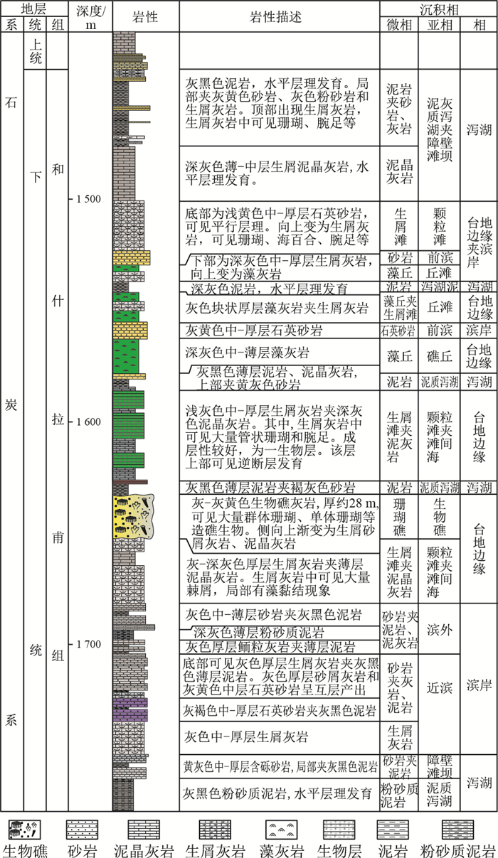
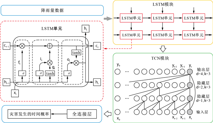
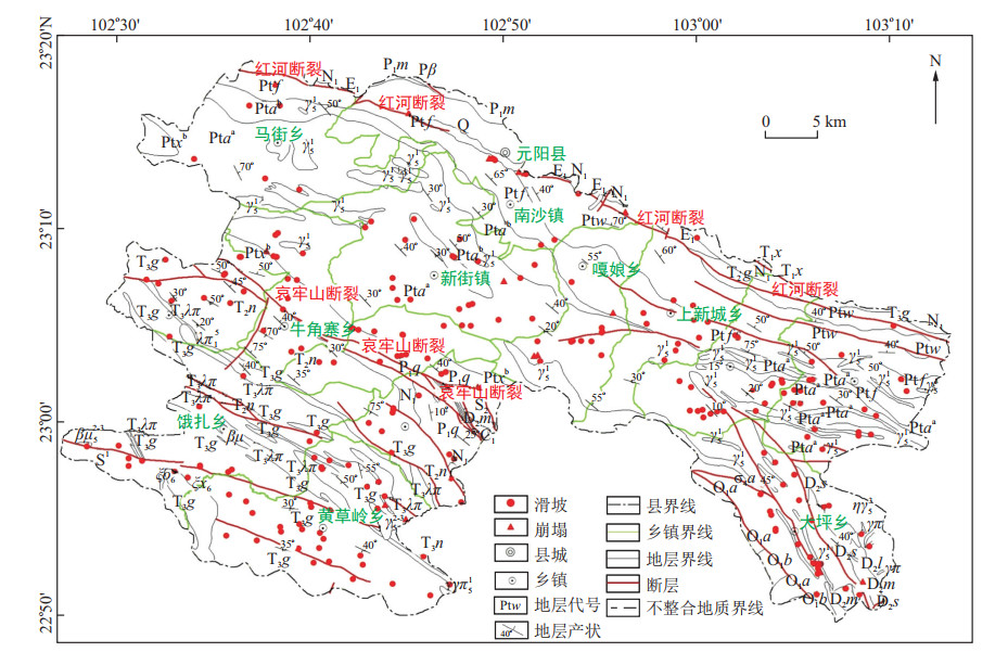
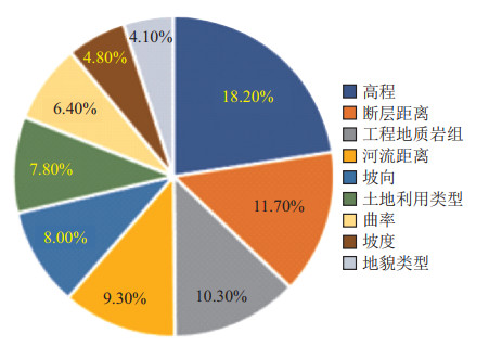
Methods

Yuanyang County, Yunnan Province, was selected as the study area, and the grid unit was chosen as the evaluation unit. Nine evaluation factors were selected, namely, landform type, elevation, slope, aspect, curvature, engineering geological rock group, land use type, distance from fault and distance from river, respectively. A weighted information model combining a subjective analytic hierarchy process and an objective information model was used to evaluate susceptibility to collapse and landslides in Yuanyang County.
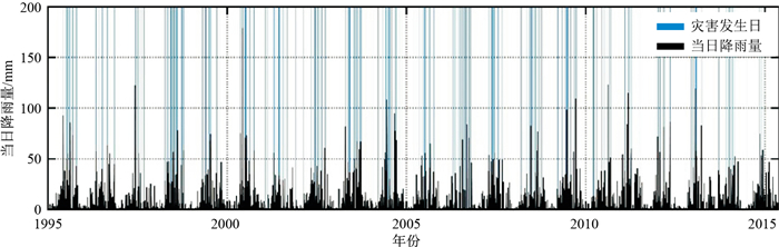
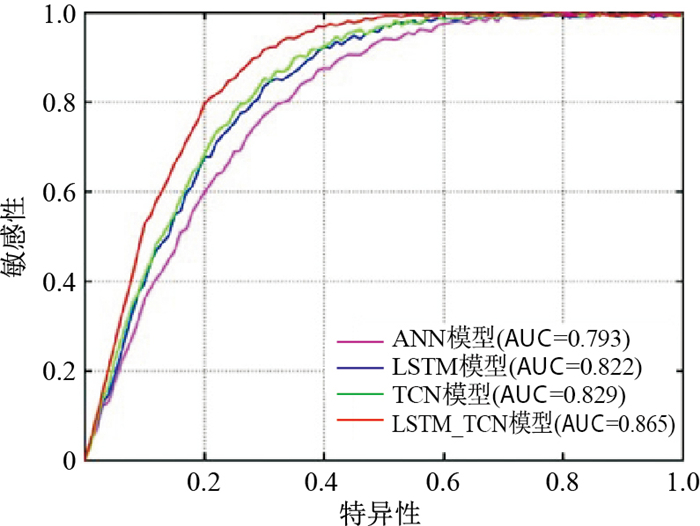
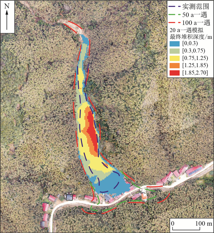
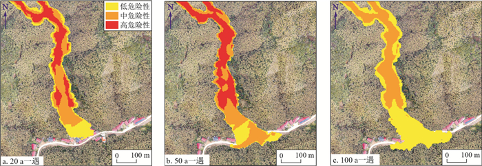
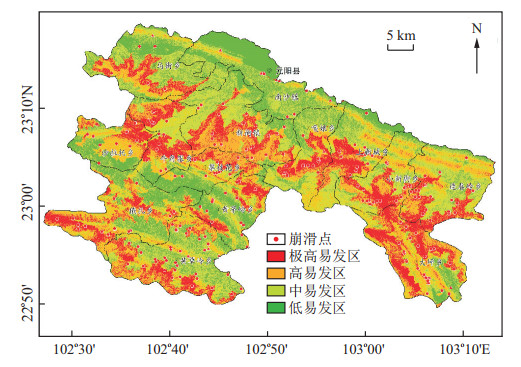
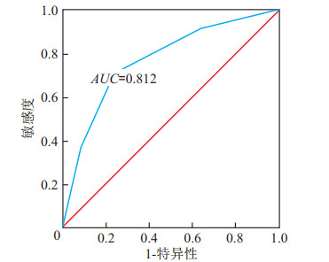
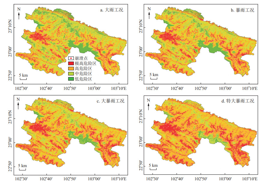
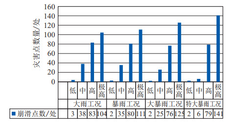
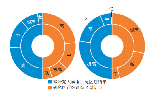
Results

According to the natural discontinuity point method, Yuanyang County is divided into four types, low, medium, high and extremely high susceptibility areas, accounting for 21.55%, 35.46%, 25.53% and 17.16% of the area of Yuanyang County, respectively. According to the ROC curve, the accuracy of the zoning results was 0.812, and the zoning results were good. Based on the susceptibility assessment, taking the annual average maximum daily rainfall as the inducing factor, risk assessments of collapse and landslide geological hazards in the study area were carried out under four working conditions-heavy rain, rainstorm, heavy rainstorm and extraordinary rainstorm, and results for collapse and landslide geological hazards under four conditions: heavy rain ([25, 50) mm) and rainstorms([50, 100) mm), heavy rainstorm ([100, 250] mm) and extraordinary rainstorm (>250 mm) data were thus obtained. The results of geological hazard risk assessments under different rainfall conditions are compared and analysed, and the spatial rationality of geological hazard risk assessment results under different rainfall conditions is determined.

Conclusion

The collapse and landslide hazard evaluation results under different rainfall conditions are highly consistent with the actual survey results, confirming the high reliability and rationality of the evaluation results.

Recharge coefficients and recharge mechanisms of precipitation to groundwater in karst areas of North China: A case study of Yangzhuang karst water system
KANG Fengxin, ZHENG Tingting, FENG Yawei, XU Qiuxiao, LIU Bintao, WANG Yisheng, LI Chuanmo
2024, 43(2): 268-282. doi: 10.19509/j.cnki.dzkq.tb20220477
Abstract:
Objective

To establish a series of hydrogeological parameter for karst areas in North China, an on-site experimental study on water balance has been carried out since the 1980s in a closed spring-drainage karst water system in Yangzhuang, Shandong Province.

Methods

Based on long-term field observations of water balance elements spanning more than 40 years, the formulas for calculating precipitation infiltration recharge coefficients in bare, semi-covered and covered karst areas were derived. The correlation equations of the precipitation infiltration recharge coefficient α with precipitation P and water table depth D, as well as the series of adjustable maximum precipitation infiltration recharge coefficients in karst areas, were also established. The processes of precipitation infiltration and recharge and the mechanism of α change were explored.

Results

The results showed that α varied with D. Each rainfall segment P corresponded to a maximum precipitation infiltration recharge coefficient αmax and a maximum precipitation infiltration recharge volume, namely, the recharge limit Gmax, while the corresponding depth of water table was the optimal depth of water table Dcritical. When D was greater than Dcritical, the interception of the vadose zone increased with increasing water table depth and α was less than αmax.When D was less than Dcritical, the surface runoff increased with decreasing water table depth and α was less than αmax. Different rainfall segments corresponded to different Dcritical, and the corresponding αmax and Dcritical increased with increasing precipitation. At any water table depth, Gmax was constant and equal to the difference between the critical rainfall of saturation excess runoff and the maximum interception volume of vadose zone.

Conclusion

This study addressed the key scientific issues related to precipitation infiltration recharge in karst areas and improved the research level of karst water resources in North China.

Identification of indicators of antibiotic pollution in typical karst groundwater in southwestern China
HUANG Fuyang, SHAN Tingqian, LIN Jing, LIU Fei, WANG Bin, HUANG Yini
2024, 43(2): 283-292. doi: 10.19509/j.cnki.dzkq.tb20220466
Abstract:
Objective

The karst area in southwestern China is one of the three concentrated karst distribution areas in the world. Karst groundwater is highly susceptible to pollution from the surface due to the unique structure of aquifers.

Methods

To investigate the dominant factors influencing the spatial distribution of antibiotic pollution, clarify the correlation between antibiotics and hydrochemical parameters, and then identify the indicators of antibiotic pollution in karst groundwater systems, a typical karst groundwater system in southwestern China was selected as the research object. Thirty-five antibiotics were analysed using ultra performance liquid chromatography tandem mass spectrometry (UPLC-MS/MS).

Results

The results showed that a total of thirty antibiotics were detected in the study area, including 3 tetracyclines (< MDL -421 ng/L), 5 macrolides (28.3-884 ng/L), 9 sulfonamides (2.50-30 ng/L) and 13 quinolones (19.5-1 807 ng/L).Among them, macrolides and quinolones were the dominant antibiotics in the study area, whose spatial distribution was dominated by pollution sources and dilution effects. The results of Pearson correlation analysis showed that the concentrations of inorganic nitrogen (the sum of NH4+-N, NO2--N and NO3--N), total organic carbon (TOC), Na+ and Cl- were significantly positively correlated with the concentration of individual antibiotics, the concentration of various antibiotic species, and the total concentration of antibiotics (r=0.81-0.99, p < 0.05, N=7-8). With more stable properties than inorganic nitrogen, TOC and Na+, Cl- is a more reliable indicator of antibiotic pollution in groundwater in karst areas.

Conclusion

This study provides a theoretical basis for the identification and prediction of antibiotic pollution in karst areas affected by county-level wastewater treatment plants (WWTPs) and rural domestic wastewater discharges.

Pollution characteristics and health risk assessment of volatile organic compounds in groundwater in a decommissioned oil refinery in Northwest China
LI Miao, LIU Weijie, YU Yue, XING Xinli, ZHANG Yuan, LI Xiaoqian, LIU Yunde, QI Shihua
2024, 43(2): 293-306. doi: 10.19509/j.cnki.dzkq.tb20220475
Abstract:
Objective

Volatile organic compounds (VOCs) can exist in groundwater for a long time, thus causing harm to human body.

Methods

To characterize the volatile organic compounds (VOCs) pollution in the organic-contaminated phreatic zone beneath a decommissioned oil refinery in Northwest China, investigations and sample testing were carried out and possible health risks were assessed in the study area.

Results

A total of 18 VOCs were detected in the groundwater at the site, with detection rates ranging from 6.25% to 56.25%. Benzene and 1, 2, 4-trimethylbenzene were the main characteristic pollutants, with adetection rate being 56.25%, both of which exceeded the class Ⅲ standard of the Groundwater Quality Standard (GB/T14848-2017) in China by 50%. The pollutants at the site mainly originated from the vertical seepage from the former liquefied gas storage tank area and the former diesel oil irrigation area, indicating that these two areas may be the main pollution sources of groundwater at the site. The distribution of pollutants was influenced by hydrogeological conditions and groundwater flow direction, with pollution occurring in groundwater downstream of the site.The results of the health risk assessment showed a predominant health risk posed by drinking water. 83.3% of the points had a cancer risk (CR) value greater than 10-6, indicating a possible cancer risk. The CR value for GW11 located in the residual oil tank area was greater than 10-4, indicating a significant cancer risk. 50% of the points had a hazard quotient (HQ) greater than 1, which would pose a noncarcinogenic risk and influence human health.

Conclusion

Therefore, the attention and control of regional drinking water issues should be strengthened in the future.

Heavy metal sources and ecological risk assessment of typical lead-zinc mining areas in Hebei Province
LIU An, YU Congling, WANG Liping, SONG Juanjuan, SUN Lianwei, JIN Qian, SUN Menghua
2024, 43(2): 307-317. doi: 10.19509/j.cnki.dzkq.tb20230373
Abstract:
Objective

To reveal the sources and ecological risks of heavy metals in a typical lead-zinc mining area in Hebei Province, 156 soil samples were collected around a zinc mining area in Hebei Province through a systematic field sampling method.

Methods

The sources of heavy metals in the area were analysed via principal component analysis(PCA) and a positive matrix factorization(PMF) model. The risk assessment was carried out according to the index of geoaccumulation method and potential ecological risk index method.

Results

The results show that the mean values of Cr, Ni, Cu, Zn, As, Cd, Pb and Hg are 53.6, 25.7, 62.7, 692, 10.6, 1.75, 142, 0.129 mg/kg, respectively. Except for Cr, Ni and As, the other 5 elements present at different pollution levels. Above the background values of the soils in Hebei Province, the coefficient of variation of Hg, Cd, Zn, Pb and Cu is more than 1.75, and the coefficient of variation of As exceeds 0.5, indicating the high variability of these 6 elements. The results of the source analysis reveal that the main sources of soil heavy metals include mining activities, natural sources, agricultural activities, and gold smelting. Zn, Cd and Pb were mainly derived from mining activities; Cr and Ni were influenced by natural parent materials and were derived from natural sources; Cu was mainly derived from agricultural activities and mining activities; As was controlled by natural sources, mining activities and agricultural activities; and Hg was originated from mainly gold smelting and mining activities. The combination of PCA and the PMF model to corroborate each other facilitates the reliability of the heavy metal source analysis results.

Conclusion

There is anthropogenic Hg and Cd contamination in this area, as indicated by the high geoaccumulation indices and potential ecological risk indices. In addition, the ecological risk in general was found to be very high, and attention needs to be given to and management work to be carried out.

Source-sink processes of marine black carbon in the context of "carbon neutrality"
XIA Cuimei, WANG Nan, LIU Jingyu, WANG Yipeng, ZHENG Guangjin, BAO Rui
2024, 43(2): 318-329. doi: 10.19509/j.cnki.dzkq.tb20220455
Abstract:
Objective

Black carbon is a carbonaceous mixture formed by the incomplete combustion of biomass and fossil fuels. Since black carbon has a high carbon content and an aromatized molecular structure, it can persist in the natural environment, suggesting that black carbon is an important component of the global carbon cycle. Although pioneering studies have advanced the understanding of nature, circulation fluxes, and reserves of black carbon in the geosphere, it is still necessary to further clarify the source-sink processes of black carbon and explore the importance of black carbon in the global carbon cycle.

Methods

Here, this study reviews the available data on pathways, fluxes, and time scales of the global black carbon cycle and analyses and summarizes the migration mechanisms and constraints in the source-sink process of marine black carbon.

Results

This paper concludes that marine sediments serve as a large reservoir for black carbon, with a reserve of 569-1 380 Pg. Black carbon can persist over millennia in marine sediments, which is associated with a long turnover time as an "effective carbon sink" in the context of "carbon neutrality". Moreover, black carbon exerts a negative feedback effect on global warming due to its longer turnover cycle time than biomass carbon. The deposition of black carbon into the sea is an effective means to enhance carbon sequestration in the ocean and could be an effective way to implement the carbon capture, utilization, and storage (CCUS) strategy.

Conclusion

In this paper, we propose that human-induced production of black carbon from biogenic combustion may be actively regulated and that the deposition pathways and burial areas of black carbon into the sea should also be optimized given the premise of ecological and environmental friendliness based on a summary and assessment of the strategic value and climate significance of black carbon in marine sediments in the context of "carbon neutrality". Therefore, the positive role of black carbon in "negative ocean carbon emissions" can provide a basic theoretical framework for achieving the goals of "carbon neutrality".

Estimation of karst carbon sinks and analysis of their driving factors in Hubei Province from 2019 to 2021
WANG Yijie, MA Chuanming, GUO Jing, DANG Huihui, HUANG Peng, FAN Wei
2024, 43(2): 330-343. doi: 10.19509/j.cnki.dzkq.tb20220534
Abstract:
Objective

Carbonate rocks have a significant carbon sink effect in water cycle. Since karst landforms are widely distributed in China, research on the potential of karst carbon sinks plays an important role in formulating regional strategies for increasing carbon sinks.

Methods

In this study, groundwater monitoring points in Hubei Province, which is located in the karst area of Southwest China, were selected. Quantitative calculations and method comparisons were performed based on the hydrochemical runoff method and the infiltration-equilibrium chemistry method. The spatial pattern and magnitude of karst carbon sinks in the hilly mountains of Hubei Province from 2019 to 2021 were evaluated via ArcGIS spatial analysis techniques. Additionally, the most suitable method for estimating karst carbon sinks at the regional scale were explored, the comprehensive analysis of the drivers of karst carbon sinks was performed, and the potential for increasing sinks were explored.

Results

The results showed that: (1) the intensity of carbon sinks estimated by the infiltration-equilibrium chemistry method were 2020>2019>2021. The total amount of karst carbon sinks in wet year (2020) was approximately 6 times of that in dry year (2019). The average annual carbon sink intensity in the three years was 12.84 t/(km2·a) and the annual total amount of carbon reached 163.89×10⁴ t/a; (2) the infiltration-equilibrium chemistry method was more accurate in calculation results and simpler in data acquisition than the hydrochemical runoff method, and had a certain universality at both large and small spatial scales; (3) the change in carbon sinks was highly dynamic. The extent of changes in carbon sinks under climate change was mainly determined by runoff depth, with the intensity of carbon sinks increasing with runoff depth, while land use regulated the intensity of carbon sinks in karst processes; and (4) the karstification is strong in southwestern Hubei Province, so a pilot field of karst carbon sinks could be established within the area to quantitatively evaluate artificial interventions to increase carbon sinks.

Conclusion

This study not only provides an accurate and easy-to-use method for estimating karst carbon sinks, but also determines the magnitude and spatial pattern of karst carbon sinks in Hubei Province and figures out the coupling effect of the driving factors of carbon sink intensity, which demonstrates the complexity and anthropogenic control lability of karst carbon sinks. The results of this study provides a reliable scientific basis for the formulation of environmental protection policies and artificial sink increase measures.

Two-dimensional magnetotelluric inversion method based on deep learning
WANG Fang, XIONG Jie, TIAN Huixiao, LI Siping, KANG Jiashuai
2024, 43(2): 344-354. doi: 10.19509/j.cnki.dzkq.tb20220471
Abstract:
Objective

The inversion of magnetotelluric sounding data to improve the accuracy of data interpretation has always been an essential topic in magnetotelluric sounding.

Methods

To address the problems of traditional magnetotelluric inversion methods, such as the dependence of the initial model and the ease of falling into a local optimum, this paper proposes a magnetotelluric inversion method based on deep learning.The method begins with the design of the GoogLeNetINV neural network. Then, various geoelectric models are constructed, and apparent resistivity data are extracted via forward modelling in the TM mode, constituting the training dataset. Additionally, the neural network is trained with the training dataset, and the network parameters are adjusted. Finally, the apparent resistivity data are input into the trained GoogLeNetINV neural network to directly obtain the inversion result.

Results

The experimental results reveal that the location and resistivity data of the "unlearned" geoelectric model can be inverted quickly and accurately, and the model has good generalization ability. The use of noise data can still yield good inversion results and a certain anti-noise ability.

Conclusion

The neural network is applied to the field data processing of the Bendigo Zone, and the resistivity model derived through inversion is consistent with the seismic interpretation. Consequently, the magnetotelluric inversion method based on deep learning can effectively solve the magnetotelluric inversion problem.

Rock magnetism of the Upper Ordovician Zhaolaoyu Formation of the southern Ordos Basin
LAN Shuqi, WEI Bitian, XING Longyun, DU Nan, LENG Xiangang, JIANG Nan, CHENG Xin, CHEN Qinglong, WANG Baofeng, XU Pengxiang, DENG Xiaohong, ZHANG Dongmeng, LI Teng, LIU Feifan, WU Hanning
2024, 43(2): 355-369. doi: 10.19509/j.cnki.dzkq.tb20220647
Abstract:
Objective

Palaeomagnetic methods can be used to quantitatively constrain the Early Palaeozoic palaeo-position of the North China Block (NCB), which provides a crucial scientific basis for researching the evolution of the Proto-Tethyan Orogeny and the affinity of the NCB for Gondwana. However, the NCB has undergone considerable tectonic activity since the Early Palaeozoic, and the Ordos Basin in the western part of the NCB is rich in hydrocarbon resources. Late tectonic activity and the migration of hydrocarbon resources may have caused remagnetization of Early Palaeozoic strata.

Methods

Thus, in this paper, to determine the main magnetic minerals in various rocks and their ability to record the primary remanent magnetization, we carry out a series of detailed petrography, rock magnetism and stepwise demagnetization experiments on the limestone and tuff samples of the Upper Ordovician Zhaolaoyu Formation in the Fuping area of the southern Ordos Basin, including optical microscope identification, scanning electron microscopy (SEM), energy dispersive spectroscopy (EDS), saturated isothermal remanent magnetization (SIRM) acquisition curve, three-axis isothermal thermal demagnetization test, κ-T curve test, hysteresis loop experiment, first-order reversal curve (FORC), and thermal demagnetization and hybrid (TD+AF) demagnetization.

Results

The results indicate that the main magnetic minerals in the limestone and tuff samples are magnetite, pyrrhotite and/or greigite, and some samples also contain a tiny quantity of haematite with impurities and goethite. Mineral particles possess single domains (SDs) as well as multiple domains (MDs) within their magnetic domains. Combining petrographic and demagnetization data, this paper suggests that the main magnetic minerals in the samples are likely secondary minerals associated with later fluid alteration (maturation and migration of organic matter).

Conclusion

The remanent magnetic signals conveyed by these rocks cannot be directly used to constrain the Early Palaeozoic palaeoposition of the NCB but may be used to constrain hydrocarbon migration and accumulation in the Lower Palaeozoic strata of the southern Ordos Basin.

Fusion processing of multisource remote sensing images for extracting characteristic information from the Geladandong Snow Mountain area
XU Wei, YANG Defang, CHEN Lihao, LUO Kaishu, ZHANG Shengpeng, ZHANG Yanze, LI Long, CHEN Gang
2024, 43(2): 370-385. doi: 10.19509/j.cnki.dzkq.tb20220545
Abstract:
Objective

In July 2022(Beijing time), the glacier survey group and mountaineering group of the China University of Geosciences (Wuhan) performed the "Second University Students' Scientific Expedition to the Yangtze River" in the Geladandong Snow Mountain area.

Methods

To analyse the spatial and temporal characteristics of glaciers in this region, scientific research data were combined with optical remote sensing image interpretation, InSAR deformation information extraction, LiDAR altimetry measurements, and high-precision geodetic survey data to conduct multisource remote sensing image fusion processing research. Aerial triangulation encryption, frequency domain image matching, the waveband ratio method, and visual interpretation were used to extract DOM, DSM, glacier area and number distribution information from high-resolution satellite GF1, GF6, GF7, ZY3, and Landsat 7 remote sensing images of Geladandong Snow Mountain and typical glaciers.Sentinel-1A and ICESat-2 images were used, supported by the cross-correlation offset tracking method in the SAR image space domain, to extract glacier surface velocity and elevation changes, respectively. The 3D spatial coordinates and elevation outliers of all the control points were calculated for the BDS CORS station in Qinghai Province using the Gamit/Globk double difference ionospheric combination model, real-time extended (RTX), and real-time kinematic (RTK) techniques.

Results

The results revealed 512 glaciers in the Geladandong Snow Mountain area, with an average annual growth rate of 3.12%, an area of 1 111.96 km2, and an average annual retreat rate of 0.63%.The average daily maximum velocity of the Jianggen (gu) Diru glacier is 0.25 cm/d, and the average annual maximum velocity is 91.25 cm/a. The maximum retreat value, accumulation value and annual change rate of Jianggen (gu) Diru glacier on the south side and north side are -74.63 m, 38.44 m, -5.29 m/a to 3.09 m/a, -39.17 m, 35.74 m, -3.02 m/a to 2.85 m/a, respectively. The precision of the regional quasigeoid refinement model and the errors at all control sites both attained mm levels.

Conclusion

The aforementioned findings can provide data support for subsequent research on glaciers in this region.

Remote sensing investigation and development distribution of historical earthquake-induced landslides along Lushi Expressway
WEI Xu, PENG Zhizhong, LIU Xingchen, XIAO Lizhi
2024, 43(2): 386-396. doi: 10.19509/j.cnki.dzkq.tb20220653
Abstract:
Objective

The fault structure along the Lu (ding) Shi (main) highway has developed, and earthquakes are frequent, resulting in a large number and large scale of historical earthquake-induced landslides in the region. However, a large amount of vegetation grows on the surface of these seismic landslides, and it is difficult for traditional surveys to efficiently identify the distribution location and development law of earthquake landslides.

Methods

To reduce the safety hazards caused by earthquake landslides during highway construction, this paper first identifies earthquake landslides with high-precision airborne LiDAR data and verifies the accuracy of identification through field review.Second, high-precision airborne LiDAR images are used to analyse the deformation characteristics of seismic landslides.Finally, the spatial distribution characteristics of the seismic landslides are analysed by comprehensively considering the three major factors (6 factors) of topography, geology and earthquakes.

Results

The results show that airborne LiDAR technology can be used to effectively detect seismic landslides under vegetation layers. A total of 23 seismic landslides are identified along the Lushi Expressway Common Road, and the accuracy of field review and verification is 100%.By analysing the six factors controlling the spatial distribution of seismic landslides, it is concluded that the correlations with fault structure and earthquakes are the highest.

Conclusion

The research results provide a reference for landslide identification and investigations of expressways with dense vegetation and provide data support for landslide disaster prevention and risk assessment of the Lushi Expressway.