| Citation: | CAO Wengeng,PAN Deng,XU Zhijie,et al. Landslide disaster vulnerability mapping study in Henan Province: Comparison of different machine learning models[J]. Bulletin of Geological Science and Technology,2025,44(1):101-111 doi: 10.19509/j.cnki.dzkq.tb20230338

|
Henan Province, with its complex geomorphology, and faces the challenge of frequent landslide disasters. Therefore, efficient and accurate landslide susceptibility mapping (LSM) is of great significance for local governments and residents. However, further comparative research is needed on how to select machine learning models suitable for the landslide disaster dataset in Henan Province to improve evaluation accuracy in landslide susceptibility mapping research.
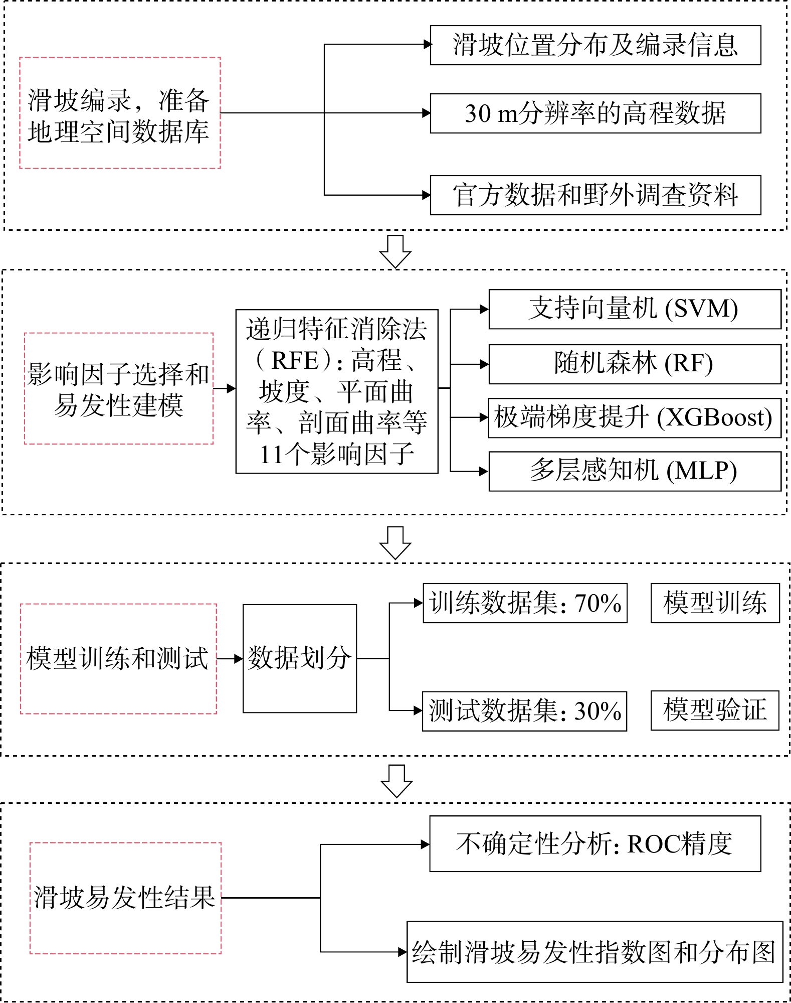
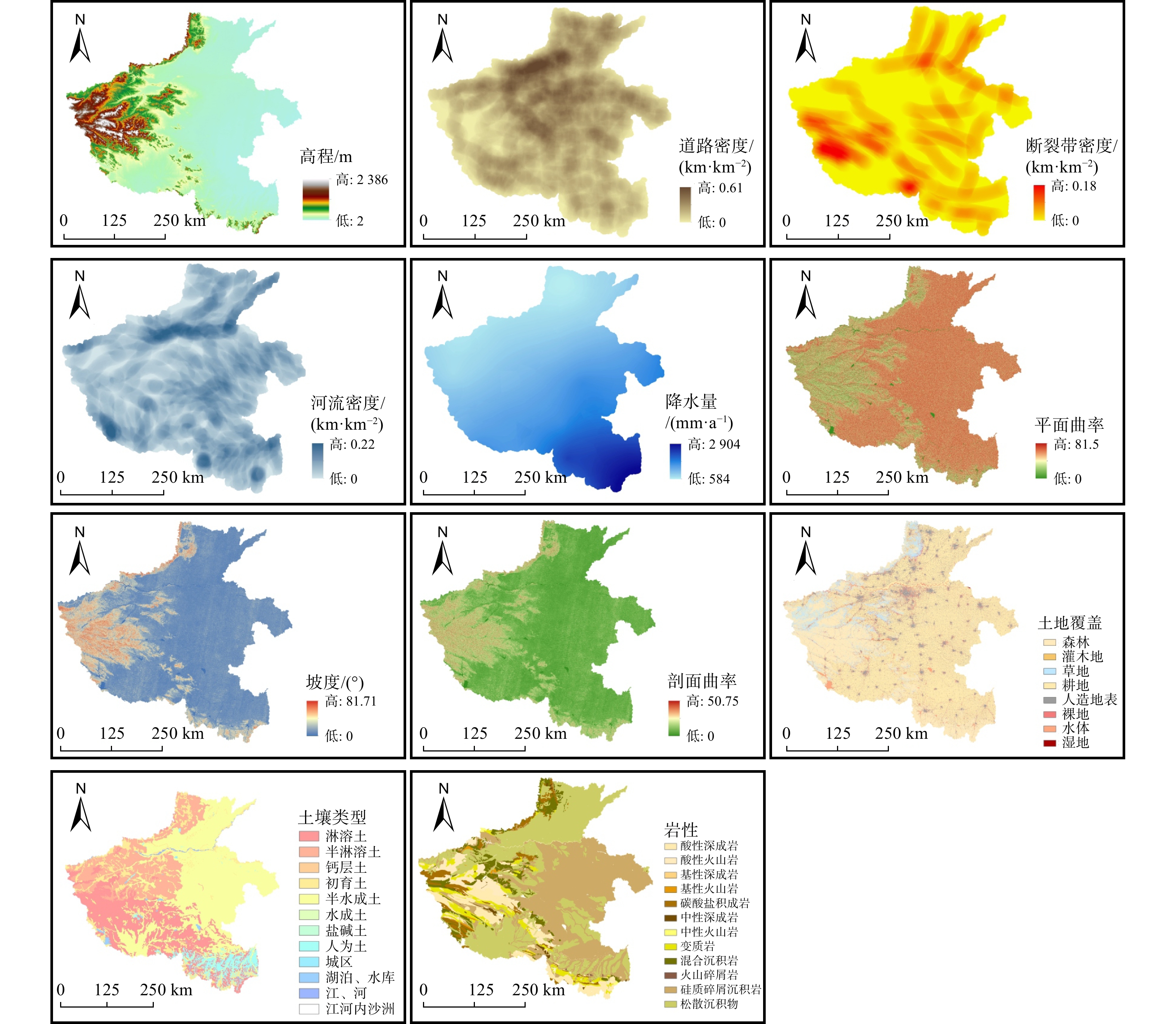
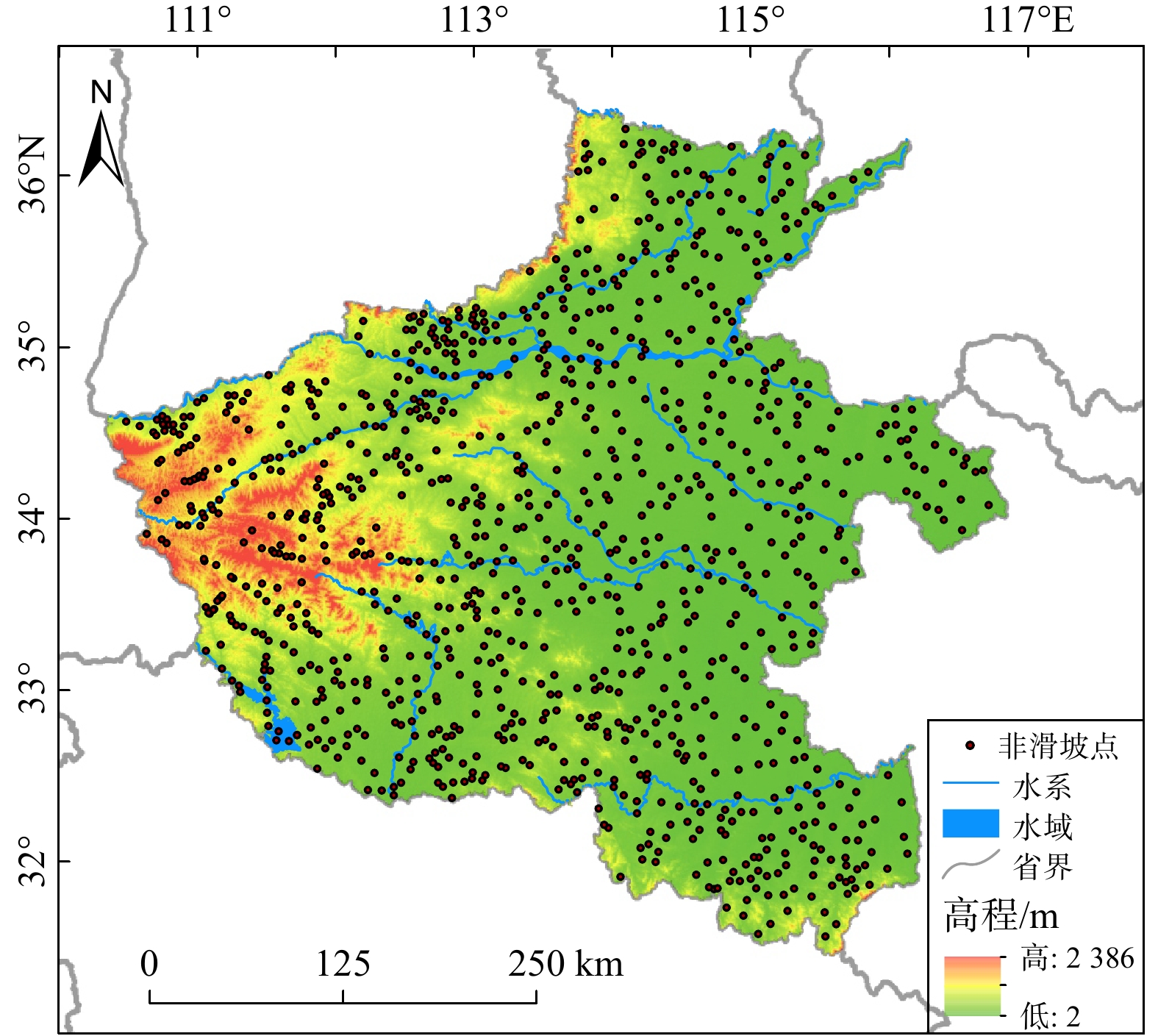
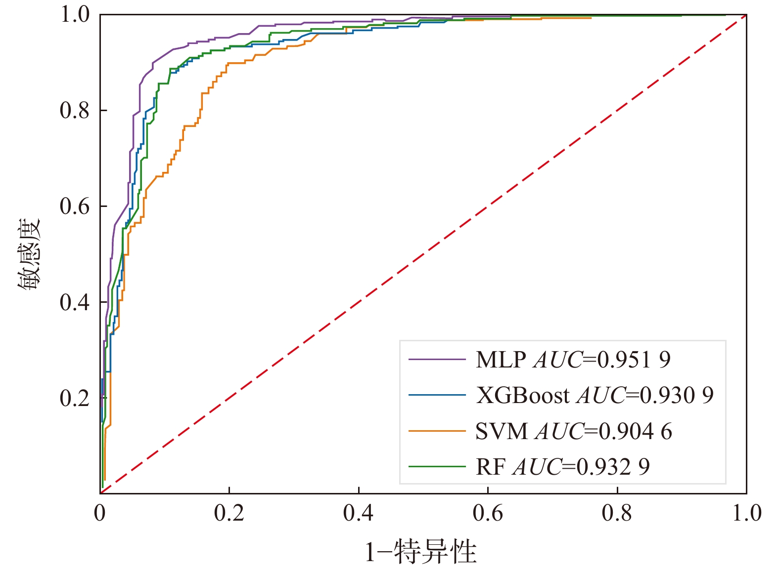
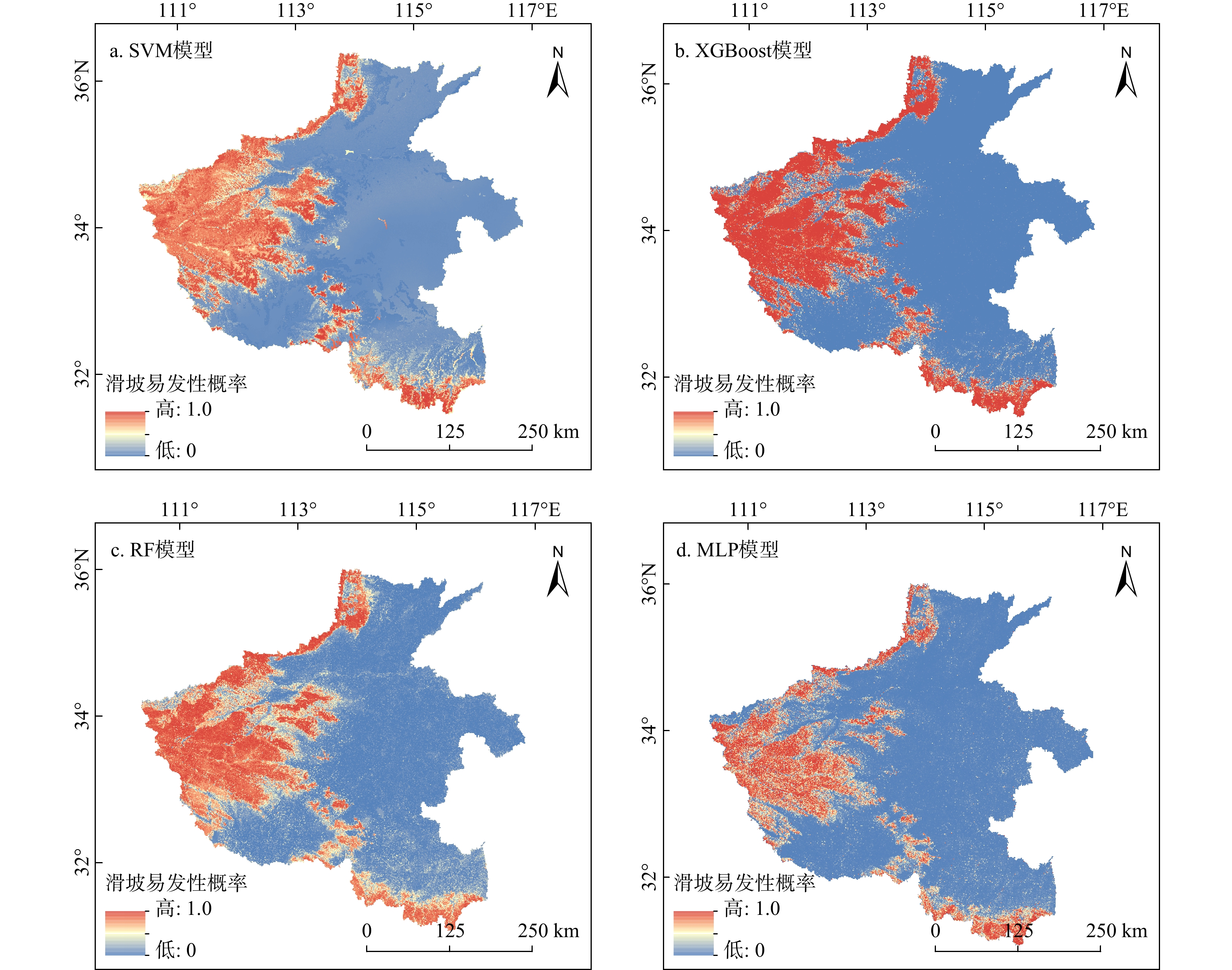
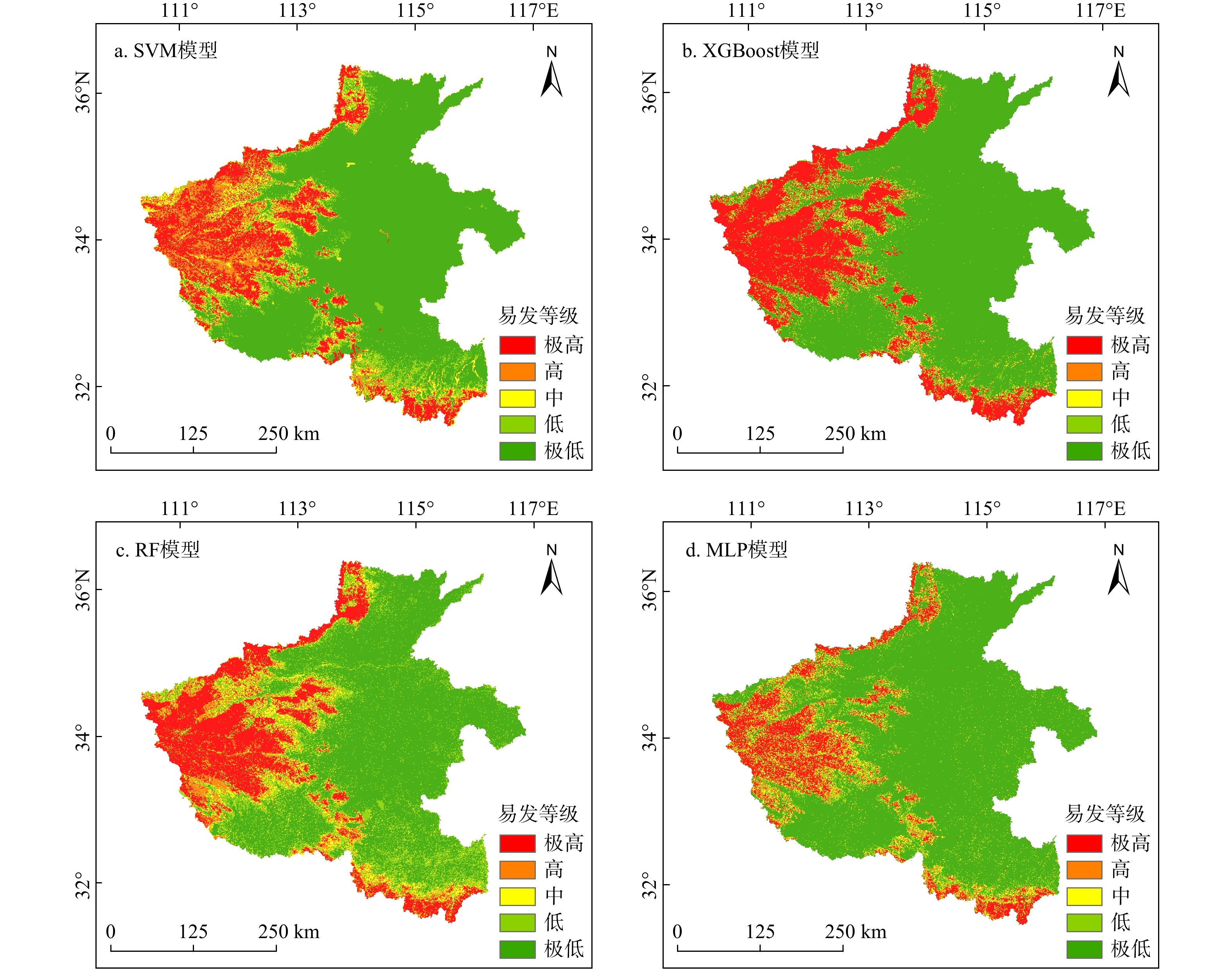
This study takes Henan Province as the research area, collected landslide data and compiled it into a landslide disaster database. By using the recursive feature elimination method, the 11 factors that have the highest relative impact on landslides (slope, elevation, plan curvature, profile curvature, land cover, lithology, soil type, precipitation, road density, river density, fault density) were selected and integrated into a spatial dataset. Multi layer perceptron (MLP) neural network, random forest (RF), extreme gradient Boosting (XGBoost), and support vector machine (SVM) models were trained, and the model performances were evaluated with receiver operating characteristic curves and the area under the curve, finally, a high-precision landslide susceptibility zoning map was created.
The MLP model showed the strongest adaptability to the landslide disaster dataset in Henan Province, with an
These results provide a high-accuracy reference for landslide susceptibility assessment over large areas.

| [1] |
赖国泉,焦海平,吴红刚,等. 山区机场高填方滑坡特征、成灾机理、防治及启示:以攀枝花机场为例[J/OL]. 地质科技通报. [2024-12-04]. http://doi.org/10.19509/j.cnki.dzkq.tb20240216.
LAI G Q,JIAO H P,WU H G,et al. Characteristics、disaster mechanism、prevention and treatment and enlighrenment of airport high fill landslide in mountainous area: Taking Panzhihua Airport as an example[J/OL]. Bulletin of Geological Science and Technology. [2024-12-04]. https://doi.org/10.19509/j.cnki.dzkq.tb20240216. (in Chinese with English abstract
|
| [2] |
BRABB E E. Innovative approaches to landslide hazard and risk mapping[C]//Anon. International landslide symposium proceedings. Toronto,Canada:[S. n.],1985:17-22.
|
| [3] |
于宪煜. 基于多源数据和多尺度分析的滑坡易发性评价方法研究[D]. 北京:中国地质大学(北京),2016.
YU X Y. Research on landslide susceptibility evaluation method based on multi-source data and multi-scale analysis [D]. Beijing:China University of Geosciences(Beijing),2016. (in Chinese with English abstract
|
| [4] |
MORAGUES S,LENZANO M G,LANFRI M,et al. Analytic hierarchy process applied to landslide susceptibility mapping of the North Branch of Argentino Lake,Argentina[J]. Natural Hazards,2021,105(1):915-941. doi: 10.1007/s11069-020-04343-8
|
| [5] |
LI Y,WANG X,MAO H. Influence of human activity on landslide susceptibility development in the Three Gorges area[J]. Natural Hazards,2020,104:2115-2151. doi: 10.1007/s11069-020-04264-6
|
| [6] |
YOUSSEF A M,POURGHASEMI H R,POURTAGHI Z S,et al. Landslide susceptibility mapping using random forest,boosted regression tree,classification and regression tree,and general linear models and comparison of their performance at Wadi Tayyah Basin,Asir Region,Saudi Arabia[J]. Landslides,2016,13:839-856. doi: 10.1007/s10346-015-0614-1
|
| [7] |
田乃满,兰恒星,伍宇明,等. 人工神经网络和决策树模型在滑坡易发性分析中的性能对比[J]. 地球信息科学学报,2021,22(12):2304-2316.
TIAN N M,LAN H X,WU Y M, et al. Comparison of the performance of artificial neural network and decision tree model in landslide susceptibility analysis[J]. Journal of Geo-Information Science,2021,22(12):2304-2316. (in Chinese with English abstract
|
| [8] |
HUANG F,CAO Z,JIANG S H,et al. Landslide susceptibility prediction based on a semi-supervised multiple-layer perceptron model[J]. Landslides,2020,17:2919-2930. doi: 10.1007/s10346-020-01473-9
|
| [9] |
PRAKASH N,MANCONI A,LOEW S. Mapping landslides on EO data:Performance of deep learning models vs. traditional machine learning models[J]. Remote Sens., 2020,12(3):346.
|
| [10] |
CHEN W,PENG J,HONG H,et al. Landslide susceptibility modelling using GIS-based machine learning techniques for Chongren County,Jiangxi Province,China[J]. Science of the Total Environment,2018,626:1121-1135. doi: 10.1016/j.scitotenv.2018.01.124
|
| [11] |
NGO P T T,PANAHI M,KHOSRAVI K,et al. Evaluation of deep learning algorithms for national scale landslide susceptibility mapping of Iran[J]. Geoscience Frontiers,2021,12(2):505-519. doi: 10.1016/j.gsf.2020.06.013
|
| [12] |
KAVZOGLU T,TEKE A. Predictive performances of ensemble machine learning algorithms in landslide susceptibility mapping using random forest,extreme gradient boosting (XGBoost) and natural gradient boosting (NGBoost)[J]. Arabian Journal for Science and Engineering,2022,47(6):7367-7385. doi: 10.1007/s13369-022-06560-8
|
| [13] |
李冬冬. 降雨诱发豫西锁固型滑坡演化机理模型试验研究[D]. 郑州:华北水利水电大学,2020.
LI D D. Experimental study on the evolution mechanism of rainfall induced locked landslides in western Henan[D]. Zhengzhou:North China University of Water Resources and Electric Power,2020. (in Chinese with English abstract
|
| [14] |
VAPNIK V N. Statistical learning theory[M]. [S. 1.]:Wiley-Interscience,1998.
|
| [15] |
OOMMEN T,MISRA D,TWARAKAVI N K C,et al. An objective analysis of support vector machine based classification for remote sensing[J]. Mathematical Geosciences,2008,40(4):409-424. doi: 10.1007/s11004-008-9156-6
|
| [16] |
KAMRAN K V,FEIZIZADEH B,KHORRAMI B,et al. A comparative approach of support vector machine kernel functions for GIS-based landslide susceptibility mapping[J]. App. Geomat.,2021,13:837-851. doi: 10.1007/s12518-021-00393-0
|
| [17] |
PATLE A,CHOUHAN D S. SVM kernel functions for classification[C]//Anon. International Conference on Advances in Technology and Engineering (ICATE). [S. 1. ]:[S. n. ],2013:1-9.
|
| [18] |
ZHANG L,ZHANG B. Relationship between support vector set and kernel functions in SVM[J]. J. Comput. Sci. & Technol.,2002,17:549-555.
|
| [19] |
BREIMAN L. Random forests[J]. Machine Learning,2001,45(1):5-32. doi: 10.1023/A:1010933404324
|
| [20] |
TAALAB K,CHENG T,ZHANG Y. Mapping landslide susceptibility and types using random forest[J]. Big Earth Data,2018,2(2):159-178. doi: 10.1080/20964471.2018.1472392
|
| [21] |
TEKE A,KAVZOGLU T. Determination of effective predisposing factors using random forest-based Gini index in landslide susceptibility mapping[C]//Anon. 2nd Intercontinental Geoinformation Days (IGD). [S. 1.]:[S. n.],2021:198-201.
|
| [22] |
郭衍昊,窦杰,向子林,等. 基于优化负样本采样策略的梯度提升决策树与随机森林的汶川同震滑坡易发性评价[J]. 地质科技通报,2024,43(3):251-265.
GUO Y H, DOU J, XIANG Z L, et al. Susceptibility evaluation of Wenchuan coseismic landslides by gradient boosting decision tree and random forest based on optimal negative sample samplingstrategies[J]. Bulletin of Geological Science and Technology,2024,43(3):251-265. (in Chinese with English abstract
|
| [23] |
CHEN T Q,GUESTRIN C. XGBoost:A scalable tree boosting system[C]//Anon. Proceedings of the 22nd Acm Sigkdd International Conference on Knowledge Discovery and Data Mining. San Francisco,CA,USA:[S. n.],2016:785-794.
|
| [24] |
FRIEDMAN J H. Stochastic gradient boosting[J]. Comput. Stat. Data Anal.,2022,38:367-378.
|
| [25] |
FAN Z Z,XU Y,ZHANG D. Local linear discriminant analysis framework using sample neighbors[J]. IEEE Transactions on Neural Networks,2011,22(7):1119-1132. doi: 10.1109/TNN.2011.2152852
|
| [26] |
付争方,朱虹,薛杉,等. 基于 Sigmoid 函数拟合的多曝光图像直接融合算法[J]. 仪器仪表学报,2015,36(10):2321-2329. doi: 10.3969/j.issn.0254-3087.2015.10.021
FU Q F,ZHU H,XUE S,et al. A direct fusion algorithm for multi-exposure images based on Sigmoid function fitting[J]. Journal of Instrumentation,2015,36(10):2321-2329. (in Chinese with English abstract doi: 10.3969/j.issn.0254-3087.2015.10.021
|
| [27] |
何平,刘紫燕. 基于改进多层感知机的手写数字识别[J]. 通信技术,2018,51(9):2075-2080. doi: 10.3969/j.issn.1002-0802.2018.09.011
HE P,LIU Z Y. Handwritten digit recognition based on improved multilayer perceptron[J]. Communication Technology,2018,51(9):2075-2080. (in Chinese with English abstract doi: 10.3969/j.issn.1002-0802.2018.09.011
|
| [28] |
CANTARINO I,CARRION M A,GOERLICH F,et al. A ROC analysis-based classification method for landslide susceptibility maps[J]. Landslides,2019,16:265-282 .
|
| [29] |
ZHENG X X,HE G J,WANG S S,et al. Comparison of Machine learning methods for potential active landslide hazards identification with multi-source data[J]. ISPRS Int. J. Geo-Inf.,2021,10:253. doi: 10.3390/ijgi10040253
|
| [30] |
杨城,林广发,张明锋,等. 基于 DEM 的福建省土质滑坡敏感性评价[J]. 地球信息科学学报,2016,18(12):1624-1633.
YANG C,LIN G F,ZHANG M F,et al. DEM-based sensitivity evaluation of earthen landslides in Fujian Province[J]. Journal of Geo-Information Science,2016,18(12):1624-1633. (in Chinese with English abstract
|
| [31] |
李郎平,兰恒星,郭长宝,等. 基于改进频率比法的川藏铁路沿线及邻区地质灾害易发性分区评价[J]. 现代地质,2017,31(5):911-929. doi: 10.3969/j.issn.1000-8527.2017.05.004
LI L P,LAN H X,GUO C B,et al. Zonal evaluation of geologic hazard susceptibility along the Sichuan-Tibet Railway and adjacent areas based on improved frequency ratio method[J]. Modern Geology,2017,31(5):911-929. (in Chinese with English abstract doi: 10.3969/j.issn.1000-8527.2017.05.004
|
| [32] |
吴辰文,梁靖涵,王伟,等. 基于递归特征消除方法的随机森林算法[J]. 统计与决策,2017(21):60-63.
WU C W,LIANG J H,WANG W,et al. Random forest algorithm based on recursive feature elimination method[J]. Statistics and Decision Making,2017(21):60-63. (in Chinese with English abstract
|
| [33] |
李萍,叶辉,谈树成. 基于层次分析法的永德县地质灾害易发性评价[J]. 水土保持研究,2021,28(5):394-399.
LI P,YE H,TAN S C. Evaluation of geologic hazard susceptibility in Yongde County based on hierarchical analysis[J]. Soil and Water Conservation Research,2021,28(5):394-399. (in Chinese with English abstract
|
| [34] |
黄发明,李金凤,王俊宇,等. 考虑线状环境因子适宜性和不同机器学习模型的滑坡易发性预测建模规律[J]. 地质科技通报,2022,41(2):44-59.
HUANG F M,LI J F,WANG J Y,et al. Modeling laws for landslide susceptibility prediction considering the suitability of linear environmental factors and different machine learning models[J]. Bulletin of Geological Science and Technology,2022,41(2):44-59. (in Chinese with English abstract
|
| [35] |
刘帅,朱杰勇,杨得虎,等. 不同降雨工况条件下的崩滑地质灾害危险性评价[J]. 地质科技通报,2024,43(2):253-267.
LIU S,ZHU J Y,YANG D H,et al. Geological hazard assessment of collapse and landslide under different rainfall conditions[J]. Bulletin of Geological Science and Technology,2024,43(2):253-267. (in Chinese with English abstract
|
Copyright © 2010Editorial Department of Bulletin of Geological Science and Technology

Supported by:
Beijing Renhe Information Technology Co., Ltd.


 DownLoad: