Current Issue

2025 Vol. 44, No. 1

Display Method:
Rock fracture detection and identification in outcrop areas via improved YOLOv7
WANG Tingting, WANG Hongtao, HUANG Zhixian, YANG Minghao, ZHAO Wanchun, ZHENG Xiongjie
2025, 44(1): 1-14. doi: 10.19509/j.cnki.dzkq.tb20230425
Abstract:
Objective

The detection of rock fractures in outcrop areas plays a pivotal role in the geological exploration of fracture-type hydrocarbon reservoirs, an essential aspect of the energy industry. Traditional image processing methods for rock fracture detection have faced limitations in providing precise results. Furthermore, the application of traditional deep learning models for rock fracture detection in complex geological settings have a low computing efficiency and accuracy.

Methods

To meet these challenges, this paper introduces an advanced and innovative rock fracture detection algorithm, known as YOLOv7-PCN. It represents a significant advancement in the field of geological exploration by improving in both accuracy and efficiency during rock fracture detection. The YOLOv7-PCN algorithm incorporates several improvements to enhance its performance. First, the PConv (Partial Convolution) module were included to replace conventional convolutions within the network backbone, which dramatically reduces computational complexity and improve the enhanced detection speed. Second, YOLOv7-PCN introduces the Coordinate Attention (CA) mechanism, a critical addition that refines the extraction of vital edge and densely-distributed features associated with fractures. It can detect and localize fractures with unprecedented accuracy, even in complex geological backgrounds. An instrumental advantage of this algorithm is the integration of the Normalized Wasserstein Distance (NWD) measurement, which are used as the bounding box regression loss function. It significantly optimizes the training convergence, leading to further improvement on localization and detection accuracy, especially for small target fractures. Notably, YOLOv7-PCN is suitable for the scenarios where rock images exhibit low resolution and complex geological contexts. To improve the model's adaptability to various datasets, YOLOv7-PCN incorporates the data augmentation into the data preprocessing pipeline.

Results

The experimental results validate the remarkable performance of YOLOv7-PCN, which attains an impressive mAP (mean Average Precision) score of 82.5% in the detection of fractures among four distinct rock categories. This achievement represents a substantial increase in accuracy, with 7.7% improvement compared to the original YOLOv7 algorithm. Remarkably, YOLOv7-PCN accomplishes these advancements while significantly reducing the number of model parameters by 29.6%, with 31.2% computational resources being saved. Furthermore, it also stands out for its exceptional detection speed, with 39.2% being increased. In summary, the YOLOv7-PCN rock fracture detection algorithm represents a transformative milestone in the realm of geological exploration. It balances the relationship between lightweight modeling and detection accuracy enhancement, which is suitable for deployment in complex geological environments. This innovation not only provides a crucial technological reference for the identification and exploration of geological rock fractures, but also makes progesses in the geological exploration of fracture-type hydrocarbon reservoirs.

Conclusion

Moreover, YOLOv7-PCN can accelerate and improve the precision of fracture detection, thereby contributing to geological studies and resource assessment.

An improved method for determining the coefficient of resource scale variation (k) in reservoir size sequential analysis and its application case
CHEN Shuangling, YU Jingdu, ZHENG Min, WANG Xiaojuan, WU Xiaozhi, WANG Jian
2025, 44(1): 15-24. doi: 10.19509/j.cnki.dzkq.tb20230371
Abstract:
Objective

Sequential reservoir size analysis based on the Pareto principle encounters challenges in accurately determining the coefficient 'k', which quantifies the gradient of resource scale variation, thereby limiting the approach's effectiveness.

Methods

This study proposes an optimized methodology for calculating 'k' by analyzing the scale ratio of discovered resources and employing possible sequential numbers. This approach involves establishing a cross-plot with sequential numbers and k-axis values based on calculated ratios, locating combinations of data points from various ratios that form approximately straight vertical lines against the k-axis, and identifying the intersection points on the k-axis as solutions for k. Further optimization principles are suggested to enhance result selection to meet resource assessment requirements.

Results

Reanalysis of classic datasets from academic literature validated the methodology's capability in accurately determining the coefficient (k). A case study of tight gas reservoirs, specifically the 6th group of Jurassic Shaximiao formations in the Yanting Block of the Jinqiu gas-producing area in the central Sichuan Basin, demonstrated favorable linear fitting results between forecasted and actual data. The calculated resource scale is in strong alignment with established tight gas exploration outcomes in the Sichuan Basin.

Conclusion

The proposed methodology reduces reliance on geological experience, eliminates the need for complex determinant models or matrix manipulations, and minimizes subjectivity and computational complexity in parameter selection. Additionally, the algorithm is available as a coded computer program, enhancing its practical efficiency and applicability in sequential reservoir size methods.

Characterization method of pore throat structure in dense sandstone based on NMR and CMP experiments
LI Hao, FAN Zhiqiang, XIE Yuxin, GONG Xiaoke, HAO Bofei, SUN Long, LEI Xiaolan, YAN Jian
2025, 44(1): 25-35. doi: 10.19509/j.cnki.dzkq.tb20230484
Abstract:
Objective

The pore structure of tight sandstone reservoirs is complex, featuring the presence of nanopores, which is essential to integrate multiple technologies for a systematic characterization of the pore structure to enhance the understanding of these reservoirs.

Methods

Six representative cores from the Chang 71 Chang Yanchang reservoir were selected for analysis. The pore types and structural characteristics of the core samples were examined using field emission scanning electron microscopy (FESEM), constant rate mercury injection (CMP), and nuclear magnetic resonance (NMR). The NMR pore distribution was adjusted based on CMP data, allowing for the identification of distribution ranges for the throat and pore radii, and a pore size classification method tailored for tight sandstone was developed.

Results

Findings indicate that the ratio of the movable water porosity to the immovable water porosity of the target reservoir is only 0.14-0.47, indicating poor seepage capacity. The integration of NMR and CMP data enabled accurate characterization of the reservoir, identifying a median throat radius of 0.151-0.525 μm and a median pore radius of 4.38-9.76 μm. The pore types include mobile water, bound water, and clay-bound water, with average saturation values of 23.4%, 14.8%, and 9.4%, respectively. The average porosities of the small pores (T2 < T2c1), medium pores (T2c1 < T2 < T2c2), and large pores (T2c2 < T2) were found to be 3.12%, 3.42%, and 1.35%, respectively. The parameter r2c1 serves as an evaluation index for the classification of reservoir seepage capacity. A decrease in r2c1 leads to a decrease in the porosity of small pores (i.e., adsorption pores) and an increase in the porosity of medium and large pores (i.e., seepage pores).

Conclusion

The research findings offer valuable insights for the selection of high-quality tight sandstone reservoirs and the enhancement of tight oil recovery.

Mechanism of CO2/N2 oil exchange in tight reservoirs based on molecular dynamics simulation
CHEN Hanzhao, WU Zhengbin, LI Xuan, SHU Kun, JIANG Shu, CHEN Zhangxing
2025, 44(1): 36-47. doi: 10.19509/j.cnki.dzkq.tb20230456
Abstract:
Objective

This research aims to investigate the storage state of tight oil and the mechanism of its replacement by CO2 through molecular dynamics simulations.

Methods

The Monte Carlo method and molecular dynamics simulation algorithms were utilized to model the storage state of alkanes with varying molecular weights on rock surfaces. These models facilitate the examination of the storage characteristics of alkane molecules on different types of rock surfaces and analyze the micromechanisms of tight oil replacement by CO2 and N2. The simulated temperature and pressure conditions (343.13 K and 20 MPa) were chosen to reflect the conditions in tight reservoirs of the Sichuan Basin.

Results

The diffusion coefficients of C7 in CO2 were measured at 1.88×10⁻⁵ m/s2 and 1.83×10⁻⁵ m/s2 for the quartz and calcite surfaces, respectively. In contrast, the coefficients in N2 were lower, measuring 6.4×10⁻⁶ m/s2 and 9.01×10⁻⁶ m/s2 for the same surfaces.

Conclusion

These findings indicate that CO2 is significantly more effective than N2 in displacing tight oil. The challenge of displacing alkane molecules from rock surfaces increases with the relative molecular weight of the alkane. In addition, alkane molecule adsorption on the calcite surface is greater than on the quartz surface. Based on the experimental results presented in this paper, the CO2 replacement mechanism can be broadly categorized into four stages: molecular diffusion, competitive adsorption, emulsification and dissolution, and a mixed-phase stage (involving low-molecular-weight alkanes).

Astrocycle identification and high sedimentation rates sedimentary filling response characteristics in the Yingxiongling shale of western Qaidam Basin
SHENG Jun, XUE Shituan, LÜ Sijin, ZHANG Caiyan, YANG Xiaojing, LI Yanan, GUO Xiao, WANG Zhuanzhuan
2025, 44(1): 48-63. doi: 10.19509/j.cnki.dzkq.tb20230492
Abstract:
<p>The exploration and development potential of the Yingxiongling shale oil in the Qaidam Basin is significant, however, current research on cyclostratigraphy is relatively limited.</p></sec> <sec><title>Objective

To clarify the characteristics of the astronomical cycle sedimentary response of Yingxiong Ling shale,

Methods

This study conducts a spectral analysis of four wells in the upper section of the Lower Ganchaigou Formation, which was developed within the Yingxiongling shale. Based on the results of core analysis, logging, and geochemical analysis, multiple sets of Milankovitch cycles in this set of strata are identified. Based on the 404.858 ka long eccentricity period, the "floating" astronomical scale of the Yingxiongling shale is established.

Results

The sedimentation time of the Yingxiongling shale is approximately 4.86 Ma, with an average sedimentation rate of 340.44 m/Ma. This high sedimentation rate is a key characteristic of the Yingxiongling shale. The sedimentary response characteristics related to the total organic carbon content based on long eccentricity period analysis revealed that the degree of organic carbon enrichment in the Yingxiongling shale in the Qaidam Basin was controlled by the sedimentation rate. As the deposition rate increased, the total organic carbon content also increased. However, when the deposition rate exceeds 450 m/Ma, total organic carbon decreases significantly due to the dilution effect of detrital materia. Furthermore, the sedimentary structure response model developed from precession period analysis shows that when the precession parameter is at its minimum, the primary development consists of poorly organic matter-rich layered limestone. In contrast, when the precession parameter was at the maximum value, the predominant development features limestone rich in organic matter.

Conclusion

The obvious orbital forced response exhibited by the Yingxiongling shale will assist in predicting favorable sections of shale oil and provide new assist in for the efficient exploration and development of Yingxiongling shale oil in the future.

Three-stage, three-category, three-dimensional characterization and evaluation of CO2 enhanced oil recovery and geological carbon storage
WANG Zeyu, OU Chenghua, XIAO Furun, LI Hang, GUO Peipei, QUAN Haosen, YAN Bo, PENG Shixuan
2025, 44(1): 64-73. doi: 10.19509/j.cnki.dzkq.tb20230498
Abstract:
Objective

This study aims to propose a novel three-stage, three-category, three-dimensional characterization and evaluation method for CO2-enhanced oil recovery (EOR) and geological carbon storage (GCS).

Methods

This method assesses the suitability, oil recovery, and storage capacity of these projects while addressing the distinct phase differences in the mechanisms of CO2 EOR and GCS during the later stages of reservoir development. This method involves the classification of CO2 EOR and GCS suitability into three stages: 1) physical storage suitability classification based on the five-factor method; 2) physicochemical storage suitability classification based on the six-factor method; and 3) chemical storage suitability classification based on the six-factor method. Additionally, this method provides a three-dimensional characterization and evaluation of CO2 EOR and GCS. It includes a visualization-based classification and assessment of the CO2 oil recovery amount and storage capacity using the storage coefficient method. The proposed evaluation framework has been applied to a representative low-porosity and ultralow-permeability reservoir in eastern China.

Results

The calculated CO2 oil recovery and storage capacity for the sample area are 648.24 tons and 2956.84 tons, respectively. These results highlight the spatial distribution characteristics of CO2 EOR and GCS at each stage and type. Ultimately, this three-stage, three-category, three-dimensional characterization and evaluation method offers vital technical support for refining CCUS projects and provides meaningful insights for subsequent operations.

Conclusion

The findings contribute to the scientific and rational planning and implementation of CO2 EOR and GCS projects, facilitating the sustainable development of oil and gas fields and enhancing resource utilization efficiency.

Structural diagenesis and reservoir control analysis of tight sandstone in the strike-slip fault zones of the Chang 8 to Chang 6 Members in the Jinghe Oilfield
MENG Yujing, LUO Yang, ZHAO Yanchao, CHEN Honghan, PING Hongwei, FANG Xiaojun
2025, 44(1): 74-89. doi: 10.19509/j.cnki.dzkq.tb20230447
Abstract:
Objective

The distribution of tight sandstone sweet spots in the Chang 8 to Chang 6 members of the Jinghe Oilfield is primarily influenced by strike-slip fault zones and their internal structural patterns, which demonstrate significant heterogeneity. This finding indicates that tectonic diagenesis is the main controlling factor of reservoir heterogeneity.

Methods

This paper integrates various datasets to analyze structural diagenesis and reservoir formation within fault zones, thereby providing a foundation for the efficient development of tight sandstone reservoirs.

Results and Conclusions

Variations in structural stress and strain lead to differing structural diagenesis and reservoir characteristics between and within strike-slip fault zones. The key findings include the following: (1) The structural stress and strain in strike-slip fault zones show clustered distribution characteristics. The zones are categorized into high-stress–strain zones (HSSZs) and low-stress–strain zones (LSSZs). Additionally, within strike-slip faults, transtensional, transpressional, and strike-slip segments can be distinguished along the fault strike, while three major categories and eight secondary categories of lateral zoning structural patterns are summarized along the fault dip. (2) Structural diagenesis within strike-slip fault zones includes deformation bands, cementation, dissolution and replacement, microfracturing, cataclasis, and smearing. (3) The differences in structural stress and strain govern the variations in structural diagenesis and, consequently, reservoir physical properties: (a) Both the HSSZ and LSSZ experienced more significant compaction and porosity reduction compared to cementation. However, the porosity reduction caused by structural diagenesis in the HSSZ was more intense than that in the LSSZ, whereas cementation in the HSSZ was greater than that in the LSSZ. (b) Under the influence of structural diagenesis, the physical properties of different segments decrease in the following sequence: transtensional segments, fault tips, weak transtensional segments, strike-slip segments, and transpressional segments.

Disturbance law between rock fractures in the coupling process of high-voltage electric pulse and hydraulic fracturing
RAO Pingping, NING Ken, CUI Jifei
2025, 44(1): 90-100. doi: 10.19509/j.cnki.dzkq.tb20230364
Abstract:
Objective

This study aims to investigate the interaction between rock fractures during the high-voltage electric pulse and hydraulic fracturing coupling process.

Methods

Based on elasticity, fracture mechanics, and damage mechanics, the high-voltage electric pulse discharge process under a water pressure of 3 MPa was numerically simulated using the extended finite element method to analyze rock mass fractures.

Results

The results showed that under a discharge voltage of 5 kV, the maximum crack width in high-voltage electric pulse-hydraulic fracturing is 35% greater than that of traditional hydraulic fracturing. With the increasing discharge voltage, both the maximum crack width and crack initiation pressure increased, and the interference between fractures was enhanced. Additionally, the interference between crack in rock mass is also correlated to the principal stress difference, injection rate, and fracture number. Specifically, under the same voltage, higher injection rates result in longer crack lengths, a more prominent stress shadow effect, and stronger fracture interference. At the same injection rate, the greater the difference in principal stress, the more pronounced the directionality of crack extension towards the maximum principal stress. Both the initiation pressure and maximum crack width decrease with the increase of principal stress difference. Multiple crack branches can simultaneously expand and intersect, with the stress shadow area of three fractures being broader than that of two.

Conclusion

These findings provide theoretical support and a research framework for the study of underwater high-voltage electric pulse fracturing and coal seam permeability technology, laying a foundation for artificial crack control in practical applications.

Landslide disaster vulnerability mapping study in Henan Province: Comparison of different machine learning models
CAO Wengeng, PAN Deng, XU Zhijie, ZHANG Wenpei, REN Yu, NAN Tian
2025, 44(1): 101-111. doi: 10.19509/j.cnki.dzkq.tb20230338
Abstract:
Objective

Henan Province, with its complex geomorphology, and faces the challenge of frequent landslide disasters. Therefore, efficient and accurate landslide susceptibility mapping (LSM) is of great significance for local governments and residents. However, further comparative research is needed on how to select machine learning models suitable for the landslide disaster dataset in Henan Province to improve evaluation accuracy in landslide susceptibility mapping research.

Methods

This study takes Henan Province as the research area, collected landslide data and compiled it into a landslide disaster database. By using the recursive feature elimination method, the 11 factors that have the highest relative impact on landslides (slope, elevation, plan curvature, profile curvature, land cover, lithology, soil type, precipitation, road density, river density, fault density) were selected and integrated into a spatial dataset. Multi layer perceptron (MLP) neural network, random forest (RF), extreme gradient Boosting (XGBoost), and support vector machine (SVM) models were trained, and the model performances were evaluated with receiver operating characteristic curves and the area under the curve, finally, a high-precision landslide susceptibility zoning map was created.

Results

The MLP model showed the strongest adaptability to the landslide disaster dataset in Henan Province, with an AUC of 0.95. Compared to SVM, XGBoost, and RF models, the MLP model predicted the smallest landslide proportion in highly susceptible areas, and can more accurately identify potential high-risk areas for landslide disasters. The predicted extremely high and high-risk areas are mainly distributed in the mountainous and hilly areas of western Henan Province, and terrain factors play a dominant role in the development of landslide disasters in Henan Province.

Conclusion

These results provide a high-accuracy reference for landslide susceptibility assessment over large areas.

Coupling characteristics and stability evolution of ice-rich moraine soil slopes on the Tibetan Plateau under climate change
LI Qilong, ZHOU Jiaqing, LI Changdong, LIU Hongbin, WANG Xueying, LÜ Hao
2025, 44(1): 112-125. doi: 10.19509/j.cnki.dzkq.tb20240079
Abstract:
Objective

The climate warming is severe on a global scale, and the increase in temperature directly leads to a series of engineering geological problems, such as the degradation of frozen regions, thermal thawing-induced subsidence, and the failure of various types of ice-rich and frozen geological structures widely distributed in the Qinghai–Tibetan Plateau. With the increasing frequency of human production practices and engineering construction in the Qinghai–Tibet region, these problems seriously threaten the safety of people's lives and property as well as the construction process of major projects in the region.

Methods

A coupled numerical model of seepage, heat transfer, and deformation considering the water–ice phase transition was established in this study, and its efficiency and accuracy were validated by comparisons with previous experimental and simulated studies. Focusing on the widely distributed moraine slopes containing ice in the Parlung Tsangpo Basin, combined with historical meteorological data and climate prediction data (under the scenarios of SSP1-2.6 and SSP5-8.5), the multi field simulation and long-term stability calculation of slopes were carried out for 80 years from 2020 to 2100.

Results

The results revealed that the soil at different depths inside the slope body was warmed to different degrees under the effect of long-term warming process, which further leads to irreversible degradation of the frozen area inside the slope, resulting in irreversible melt-induced settlement and stability degradation. The degradation of frozen area and accompanying unfavorable geological problems are strongly affected by climate evolution patterns. As the temperature continues to rise until around 2080, the mean annual atmospheric temperature increased by 3.84℃ under SSP5-8.5, and irreversible degradation of the frozen zone and the consequent irreversible subsidence began to occur inside the slope. After the permanent degradation of the frozen zone in the surface layer of the slope in 2080, there was a significant acceleration of thawing-induced subsidence increases and stability decreases. Until 2100, thawing-induced subsidence of the slope could reach 0.06 m, and the stability of the slope decreased by 6.3% compared to 2020. This nonlinear evolution feature reveals the evolution mechanism of ice-rich soil from quantitative changes to qualitative changes under the effect of increasing temperature. However, these degradations did not appear under SSP1-2.6.

Conclusion

In this study, a multiphysics coupled simulation platform of temperature-seepage-deformation behaviors that considers the ice–water phase transition was constructed. It quantitatively evaluated the degree of degradation and instability risk of slopes under different future climate scenarios, revealed the multifield response mechanism and long-term stability evolution of ice-rich moraine slopes driven by climate. The results provide an important theoretical foundation for understanding the climate response to geological hazards in high-cold regions and assessing regional geological risk.

Threshold model of landslide rainfall in Chongqing based on different geological environment zones
XIE Yangyi, YIN Kunlong, DU Juan, LIU Shuhao, WU Liyang, LIU Xiepan
2025, 44(1): 126-137. doi: 10.19509/j.cnki.dzkq.tb20230375
Abstract:
Objective

Considering the rainfall characteristics and geological environment of regional landslides, constructing a reasonable rainfall threshold model is crucial for the prediction and forecasting regional landslide disasters.

Methods

This study takes 1368 rain-induced landslides in Chongqing from 2013 to 2021 as the research object. Based on detailed landslide data and regional geological environment information, rainfall events were divided and a landslide sample database was constructed. Using the random forest (RF) algorithm, a rainfall threshold model of the day's triggered rainfall-previous rainfall-previous effective rainfall (Rd-Rp) was established, and different warning levels were classified based on probability grading. Based on the medium early warning probability, 19 threshold criteria for critical rainfall were constructed according to four geological environments: the disaster-prone environment, engineering rock group, land use, and soil type.

Results

The results show that the Rd-Rp threshold model can effectively reflect the impact of the daily excitation rainfall and the early effective rainfall on landslide development, and that early effective rainfall plays a dominant role in landslide induction. Different geological environment types show different sensitivities to rainfall factors, and geological structures, engineering properties of rock and soil masses, vegetation coverage, and soil properties have significant effects on landslide development. The threshold of rock formations dominated by hard rocks is higher than that dominated by weak rocks, and the threshold of forest land is greater than that of cultivated land. The threshold of areas severely damaged by human engineering activities will decrease.

Conclusion

This study can provide new ideas and references for the meteorological early warning management of rainfall-related landslide disasters in Chongqing.

Shaking table test of dynamic responses and failure mechanism of hanging wall and footwall on rock slope across reverse faults
QI Shaojian, FAN Xuanmei, XIA Mingyao, WEI Tao, ZHANG Xinxin, WANG Wensong
2025, 44(1): 138-149. doi: 10.19509/j.cnki.dzkq.tb20240310
Abstract:
Objective

Near-fault landslides frequently result in catastrophic consequences under strong earthquakes, Among them, the dynamic response characteristics of earthquake-induced landslides under the influence of reverse fault activity are complex and destructive. However, there is a lack of systematic understanding, both domestically and internationally, concerning the influence of the presence and dislocation of faults on the dynamic response and failure mechanism of earthquake-induced landslides, specifically under thrust earthquakes.

Methods

In this study, the large-scale shaking table tests were conducted on rock slopes considering weak reverse fault dislocation to simulate the fault dislocation process of cross–reverse fault slopes. Combined with particle image velocity (PIV) technology, the differences in the dynamic response law and failure mechanism between the hanging wall and footwall of cross-reverse fault slopes under the influence of seismic waves with varying amplitudes and frequencies were analyzed deeply.

Results

The results show that with increasing loading amplitude and frequency, the slope amplification factors of the model increase nonlinearly. During the reverse fault dislocation process, the model slope experiences significant damage, with notable increases in amplification factors for both the hanging wall and footwall. Specifically, the peak acceleration of the hanging wall is amplified by a factor of 1.24, whereas that of the footwall increases by a factor of 1.13. Based on PIV observations, the failure mechanism of the model slope was discovered: the hanging wall was dominated by tension failure, and the tensile cracking failure was concentrated in the middle-higher edge of the slope. On the conteary, the failure of the footwall is caused mainly by tension and then shear. The footwall produces penetrating tensile-shear cracks under the friction and extrusion of the hanging wall.

Conclusion

The model tests have effectively revealed the dynamic response laws and failure mechanisms of cross-reverse fault slopes under the action of fault dislocation. The observations revealed distinct hanging wall and footwall effects, and the fault dislocation process intensified these effects in the model slope, significantly impacting the landslide failure mechanism. This study experimentally explores the hanging wall and footwall effects, as well as the failure mechanisms, of cross-reverse fault slopes, considering the reverse fault dislocation mechanism.

Characterization model for the equivalent hydraulic aperture of a nonmatching fracture based on the MIC
ZHU Yue, LIANG Ye, SUN Zihao, WANG Liangqing, FAN Binqiang, YAO Xunwan
2025, 44(1): 150-163. doi: 10.19509/j.cnki.dzkq.tb20230443
Abstract:
<p>Equivalent hydraulic aperture can quantitatively characterize hydraulic conductivity in rough fractures under Darcy flow conditions, making significance for various engineering applications. </p></sec><sec><title>Objective

The equivalent hydraulic aperture of rough fractures is influenced by complex geometric features such as wall topography and aperture distribution. This study comprehensively considers fracture geometry, applies the maximal information coefficient (MIC) method to identify key factors influencing equivalent hydraulic aperture, and develops a characterization model based on it.

Methods

900 sets of nonmatching rough fractures were generated through Barton's 10 standard curves. Geometric information from fracture walls provided 13 parameters, and numerical simulations were used to obtain the equivalent hydraulic apertures. MIC considers the correlations between equivalent hydraulic aperture and 13 geometric parameters.

Results

Four key factors were identified to form the basis of a characterization model for the equivalent hydraulic aperture of rough fractures.

Conclusion

900 rough fracture datasets validated the model's performance against two existing models, with the proposed model being more advanced than the current representations. The study also discussed the impact of size effects on hydraulic aperture models and the application for three-dimensional cases.

MLP-ANN model for predicting uniaxial compressive strength of rocks based on the rebound method
LI Ming, DOU Bin, PIAO Shenghao, MA Yunlong, WANG Shuai, SUN Zuoshuai, WANG Xiang
2025, 44(1): 164-174. doi: 10.19509/j.cnki.dzkq.tb20230452
Abstract:
Objective

The uniaxial compressive strength (UCS) of rock is an important parameter in geotechnical engineering, as well as accurately determining its value is crucial for engineering design.

Methods

This study proposed a machine learning model based on a multi-layer perceptron-Artificial Neural Network (MLP-ANN) to predict the UCS of rock. The model takes lithology, joint surfaces, Schmidt hammer rebound height, and P-wave velocity as input parameters, and applies min-max normalization to standardize these parameters. Additionally, k-fold cross-validation is used to improve the model’s generalization ability. To further optimize model performance, the paper explores the impact of the number of neurons, data splitting ratio, and activation function on prediction results.

Results

Through comparative validation, the study determines the optimal model configuration: 8 neurons, a training-to-testing ratio of 8∶2, and the Tanh activation function. The comparison between predicted and actual values shows that the optimal model achieves an average absolute error of 3.500 MPa and a root mean square error of 5.836 MPa.

Conclusion

These results indicate that the model has a small prediction error and high accuracy, illustrating good practicality.

Effect of freeze-thaw cycles on the properties of MICP-treated soil
LI Jun, ZHANG Weili, CHEN Zongwu, LI Mingyi
2025, 44(1): 175-184. doi: 10.19509/j.cnki.dzkq.tb20230462
Abstract:
Objective

The microbial induced carbonate precipitation (MICP) technology has received widespread attention from the academic community and has also made certain progress in the field of soil reinforcement. After MICP, the overall performance of the soil is improved, but the cyclic effect of winter freezing and spring thawing gradually loosens the soil structure, resulting in a decrease in soil strength, erosion resistance, and water retention capacity. Currently, there is limited research on the impact of freeze-thaw cycles on the properties of MICP stabilized soil.

Methods

This study investigated the effects of freeze-thaw cycles on the unconfined compressive strength (UCS), erosion resistance, and water retention capacity of soil treated with MICP under different conditions. The surfaces of the samples were treated via the spray method, and then, some samples were subjected to erosion tests. The UCS and water evaporation rate of the samples under different numbers of freeze-thaw cycles were tested. Combining the mechanism of soil resistance to erosion damage and the test results of samples subjected to freeze-thaw cycles, the reasons for the deterioration of reinforced soil properties due to freeze-thaw cycles were investigated.

Results

The results revealed that the UCS of the sample increased from 43.83 kPa to 69.92 kPa after MICP treatment. After 20 freeze-thaw cycles, the UCS value of the MICP-treated sample was 1.48 times greater than that of the uncured sample, and the erosion amount of the MICP-treated sample was much less than half of that of the uncured sample. Research has shown that microbial induced calcium carbonate deposits can effectively fill the internal pores of the soil and bind loose soil particles, significantly improving the soil strength and effectively weakening the destructive effect of freeze-thaw cycles on the soil.

Conclusion

Although the reinforcement effect of the soil gradually deteriorated due to the increase in the number of freeze-thaw cycles, the MICP-treated soil still had high strength in a short-term freeze-thaw environment and could effectively resist the erosion effect of rainwater.

Landslide mechanism of metamorphic sandstone area containing weak interlayers in Shuangqiaoshan Group
LIU Qing, GAN Jianjun, CHEN Hao, LI Xiaoming, LIU Yuwei
2025, 44(1): 185-193. doi: 10.19509/j.cnki.dzkq.tb20230414
Abstract:
Objective

The Shuangqiaoshan Group strata are widely exposed in East China, with complex lithology and stratigraphy, developed faults and folds, often forming weak interlayer slopes. These characteristics often create weak interlayer slopes that are prone to landslides under rainfall infiltration.

Methods

This study aims to reveal the deformation and evolution mechanisms of such slopes under rainfall conditions. Taking a typical silty clay-bearing soft interlayer landslide in Xiushui County as an example, the formation reasons and failure characteristics of the weak interlayer landslide were analyzed. A geomechanical model of accumulation landslides was established, and the landslide's response under different rainfall intensities was simulated using GeoStudio numerical analysis software.

Results

The findings are as follows: (1) An EW-trending fault zone and ductile fault zone at the landslide's rear edge combine to form four groups of cracks that control slope stability, forming a boat-shaped weak interlayer approximately 8.8 m thick in the sliding bed; (2) Rainfall infiltrates into the sliding zone composed of debris and clay, triggering the sliding body to undergo three deformation stages: early creep, mid-stage sliding surface penetration, and late-stage shear deformation; (3) Creep deformation begins when rainfall intensity reaches 9.9 mm/d. At 40 mm/d, shear deformation increases along the weak structural plane and progressively intensifies. At 120 mm/d, a connected fracture surface forms along the weak interlayer structure, ultimately accelerating instability and landslide failure.

Conclusion

These findings provide valuable insights into the prevention and management of landslide disasters in similar lithological settings.

Risk assessment of landslide geological hazards under different rainfall conditions based on the Pearson Ⅲ curves
WANG Canxing, ZHU Jieyong, YU Congjun, LIU Jiakai, ZHU Chuanbing
2025, 44(1): 194-204. doi: 10.19509/j.cnki.dzkq.tb20230472
Abstract:
Objective

Rainfall is one of the important factors that induce geological disasters, such as landslides and collapses, posing a great threat to the safety of people's lives and property. Therefore, it is necessary to take effective prevention and control measures as well as to avoid and relocate.

Methods

This study takes Yezhi Town, Weixi County, Yunnan Province as the study area, and the grid unit is used as the evaluation unit. Nine evaluation factors, including elevation, land use type, slope, aspect, elevation, landform type, engineering geological rock group, land use type, distance from river, distance from fault, and curvature were selected. The random forest algorithm and weighted information method were used to analyze the weight of evaluation factors, and a susceptibility evaluation was also made. Based on this, rainfall was selected as the risk assessment factor. By calculating and predicting the rainfall in the study area with Pearson Ⅲ curve, rainfall in the study area was predicted for every 10 years, 20 years, 50 years, and 100 years, and a risk assessment was obtained.

Results

According to statistics, the susceptibility assessment results are divided into four levels using the natural discontinuity method: low, medium, high, and extremely high-susceptibility areas, which account for 32.80%, 34.02%, 21.96%, and 11.22% of the study area respectively. The ROC curves were used to verify the accuracy, and the AUC value was 89.2%.

Conclusion

By comparing the actual investigation situation, the landslide and collapse risk assessment results under different rainfall conditions are highly consistent with the actual situation. This study provides a basis for reasonable disaster prevention and mitigation, as well as risk avoidance and relocation.

Development and application of a novel ring shear apparatus
CHEN Qiong, CUI Deshan, ZHANGYANG Jinghao, ZHU Junfeng
2025, 44(1): 205-215. doi: 10.19509/j.cnki.dzkq.tb20230340
Abstract:
Objective

This study aims to investigate the total stress, pore water pressure, and effective stress of samples by developing a new ring shear apparatus capable of measuring and controlling pore water pressure, effectively revealing the evolution characteristics of stress, strain, and pore water pressure in the samples.

Methods

A self-developed automatic ring shear apparatus that can control drainage conditions has achieved the control of pore water pressure during ring shear tests, and measuring parameters such as pore water pressure, sample drainage volume, torque, and axial displacement. Taking the Huangtupo landslide slip zone soil as an example, consolidation drained ring shear tests, consolidation undrained ring shear tests, variable pore pressure ring shear tests, and permeability tests were conducted separately.

Results

The results demonstrated that the ring shear chamber withstands pore water pressure from 0 to 1000 kPa using a side seal and three-way valves at the top and bottom. When the inlet valve at the bottom of ring shear box was opened and the volume pressure controller was controlled, the pore water pressure can be controlled, and the sample drainage or absorption volume under various pore pressures can be measured. With the outlet valve at the upper ring shear box opened, and a pore water pressure sensor connected, the undrained pore water pressure was measured in the range of 0-1000 kPa. During the test, the shear expansion and contraction were measured by an axial displacement sensors, with range of 0-10 mm, while ring shear force was measured with a torque sensor up to 300 N·m. Additionally, the new ring shear apparatus can be used to conduct tests on the influence of dynamic changes in pore water pressure on ring shear strength, as well as the constant head permeability during consolidation or ring shear processes.

Conclusion

The novel ring shear apparatus can accurately conduct ring shear tests on samples under large deformation and varying pore pressure conditions, offering technical support for revealing the evolution mechanism of pore water pressure during long-distance landslide sliding.

Hydrogeochemical characteristics and genesis of Jiusuo geothermal field in southwestern Hainan, China
ZHOU Yiying, OUYANG Zhengping, XU Zidong, WANG Wenmei, YANG Yongchang, WANG Jiangsi, HUANG Zejiao, MA Ronglin, LIANG Haiyan, LIN Yi
2025, 44(1): 216-228. doi: 10.19509/j.cnki.dzkq.tb20240242
Abstract:
<p>Hainan Island harbors abundant geothermal resources. However, previous geothermal explorations have focused primarily on production, overlooking critical research areas such as the origins of geothermal water chemistry, water-rock interactions, methods for evaluating thermal reservoir temperatures, and mechanisms of geothermal field formation. </p></sec><sec><title>Objective

This study leverages existing exploration data to deepen our understanding of the genetic mechanism of geothermal fields and to offer valuable insights for their development.

Methods

We employed a range of analytical techniques, including major ion ratios and correlations, Piper diagrams, fluoride concentration maps, silicon-enthalpy and SiO2 mixing model graphs, silicon-enthalpy equations, and water δD and δ18O values. Focusing on the geothermal water of Jiusuo, we investigated the sources of chemical components, the cation exchange processes, the origin of F events, the most likely reservoir temperatures, and the circulation depths of geothermal water, ultimately proposing a conceptual model explaining the genesis of the field.
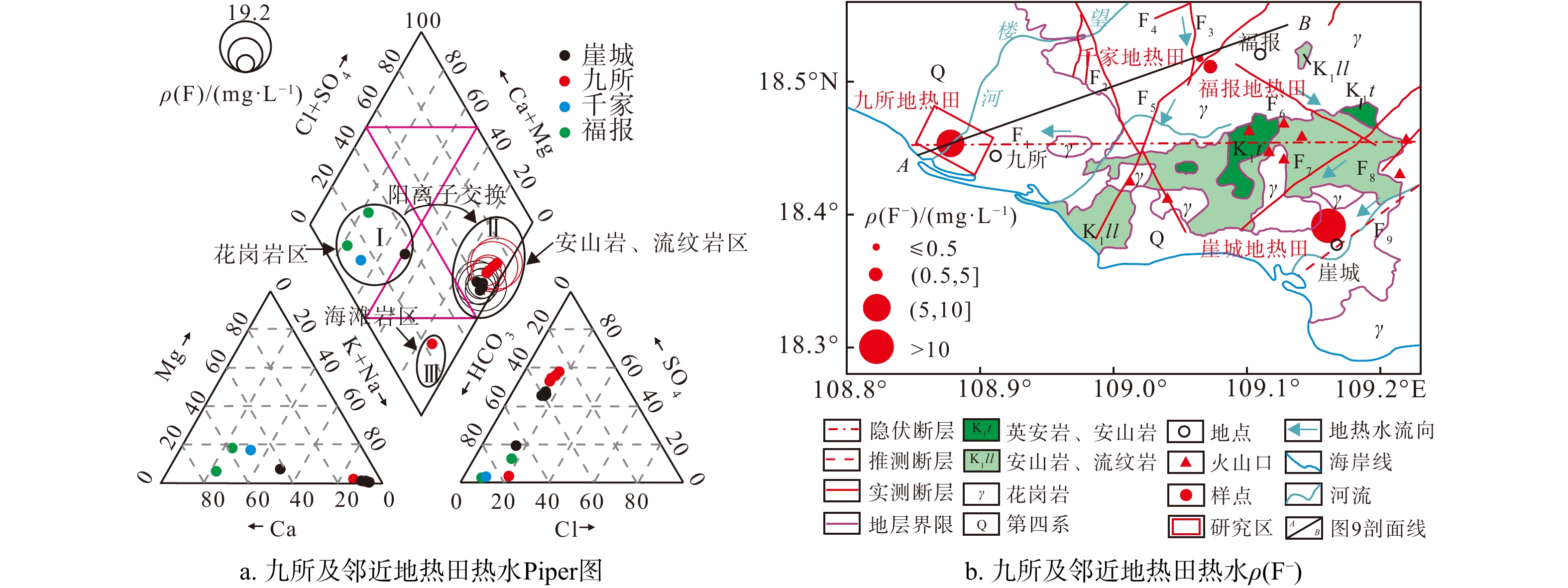
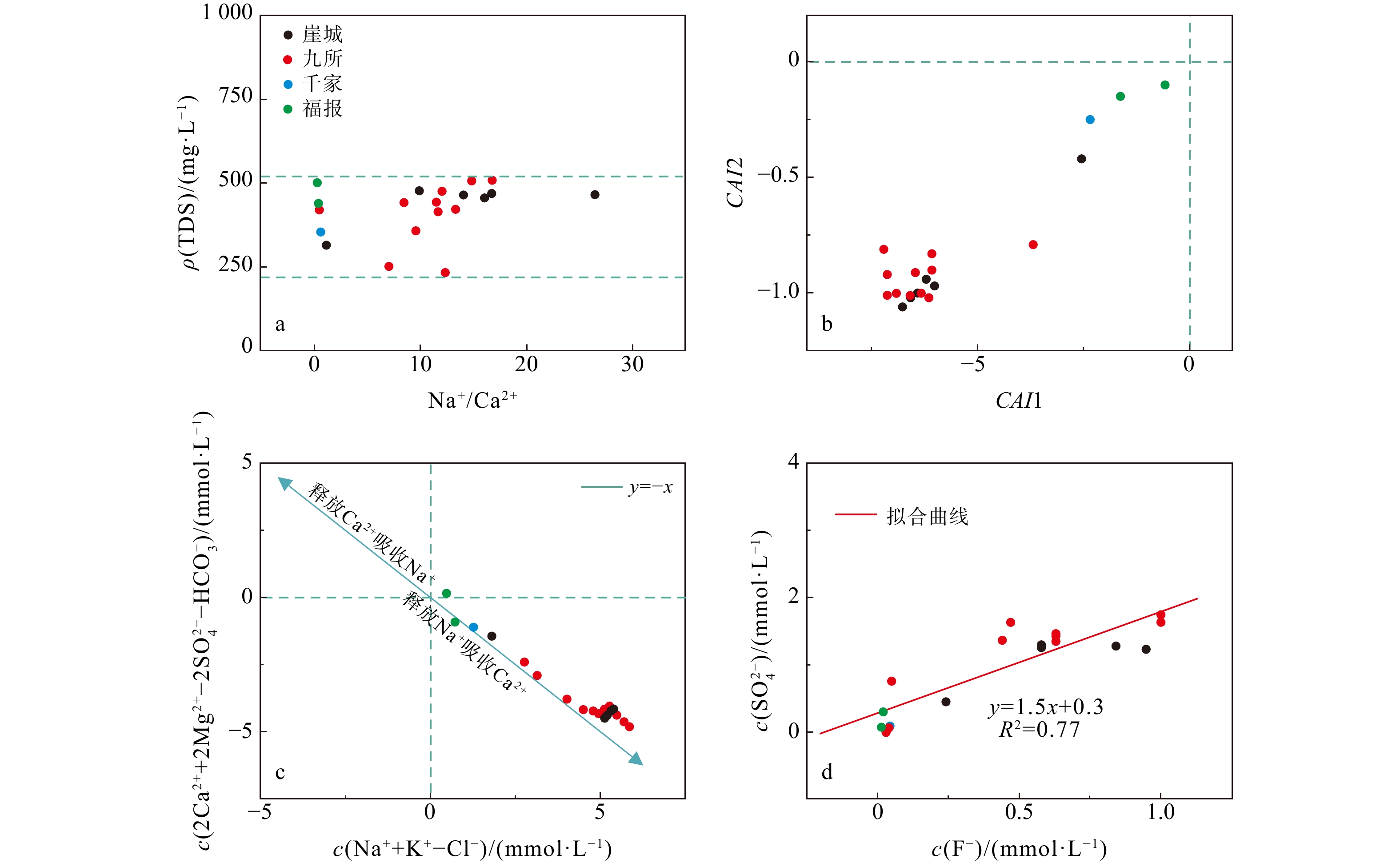
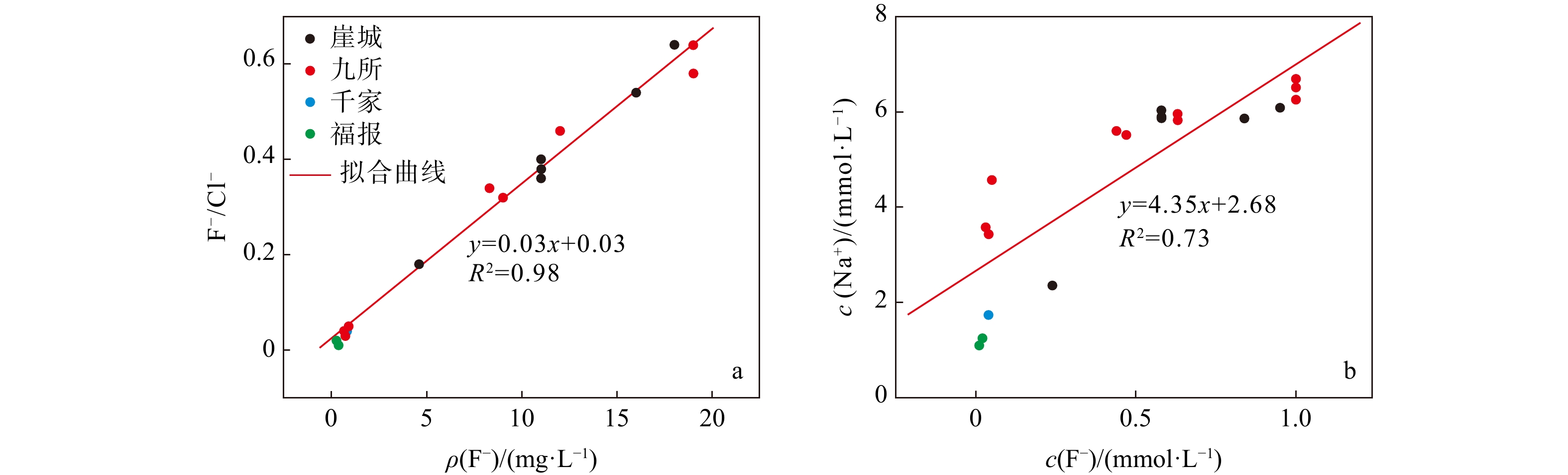
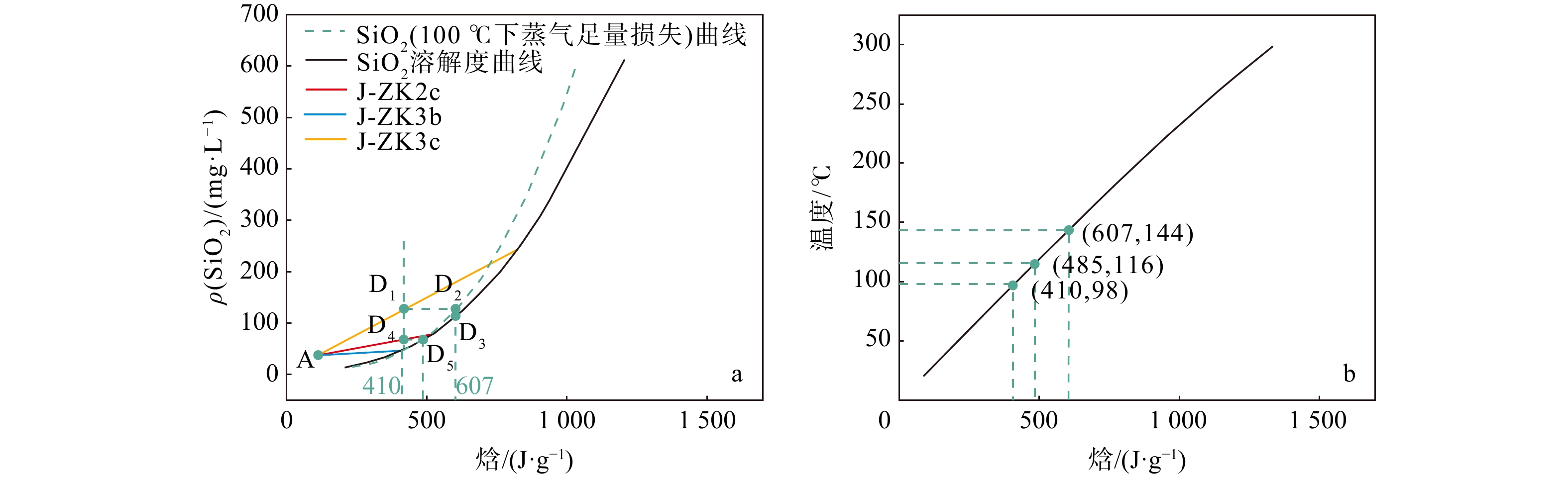
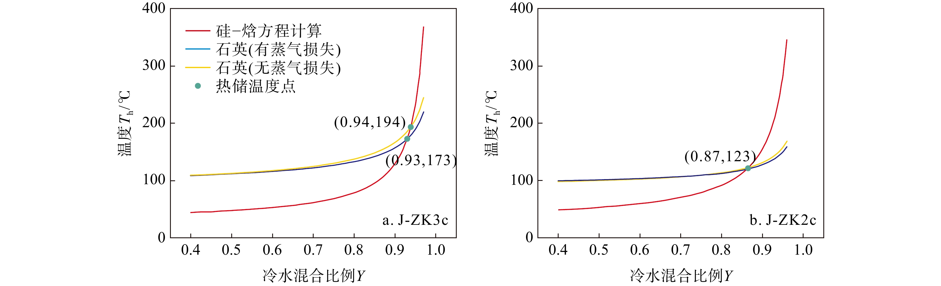
Results

The results indicate that the hydrochemistry of geothermal water is mainly characterized by SO4·HCO3-Na type, with Ca2+ and Mg2+ replacing Na+ and K+ in the rock. The primary source of SO42− is the sulfide oxidation of andesite and rhyolite. The fluoride concentration is regulated by the dissolution of minerals such as mica, amphibole, and fluorite, along with ion exchange and alkaline environments. The chemical composition is predominantly shaped by silicate mineral dissolution, ion exchange, and the degree of development of geological strata and structures. Most likely, when mixed with cold groundwater, the temperature range of geothermal water in this area falls to 99℃-169℃, with cold groundwater contributing 80% to 93% of the mix and approximately 10% steam loss prior to mixing. The circulation depth of geothermal water ranges from 1.8 to 3.8 km.
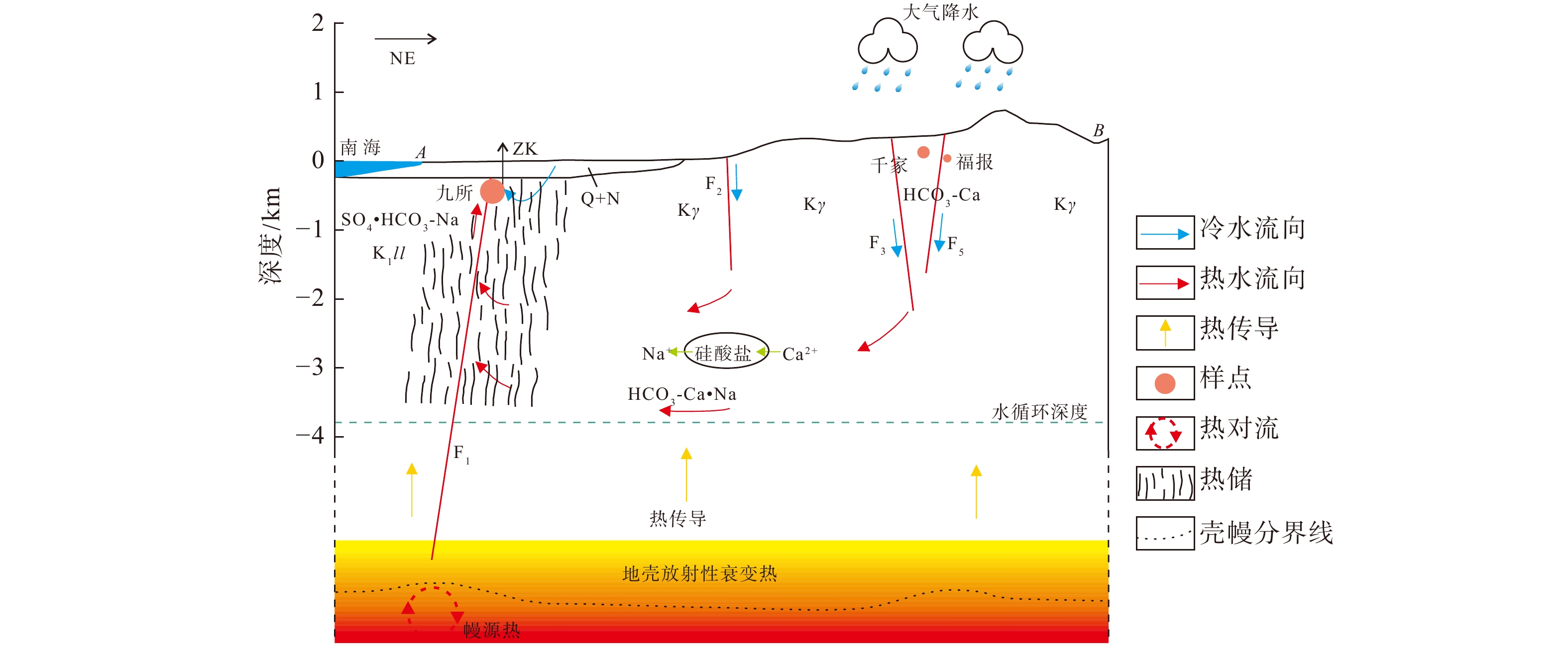
Conclusion

The proposed conceptual model suggests that the geothermal water in the Jiusuo geothermal field originates from rainfall recharge and flows under the control of the Furongtian-Wangxia structural belt, Ledong-Xichang structural belt, and Jiusuo-Lingshui deep large fault belt. The water flows from the granite areas to the andesite and rhyolite areas, where it absorbs heat from both radioactive decay in granite and potential minor mantle-derived thermal energy. This process leads to silicate mineral dissolution, cation exchange, and sulfide oxidation, resulting in increased concentrations of fluoride ions (F), sulfate ions (SO42−), and other chemical components in water. These processes cause an evolution in water chemical types. Owing to the increase in temperature, the density and viscosity of geothermal water decrease, and the pressure increases, generating buoyancy. Driven by both the hydraulic gradient and buoyancy gradient, geothermal water ascends along the Jiusuo-Lingshui deep large fault belt and rock fractures in the subsurface. It then mixes with cold groundwater near the surface before being embedded in the Quaternary and Tertiary sedimentary layers, ultimately forming a geothermal field. While mantle-derived thermal energy's presence in the deep region of geothermal fields in southwestern Hainan remains unconfirmed, it presents an intriguing scientific question meriting further investigation.

Chemical clogging pattern of hot reservoir tailwater recharge in the Guantao Formation, northern Shandong, China
TAO Weiyu, ZHENG Jun, DOU Bin, TIAN Hong, LAI Xiaotian, ZHANG Han
2025, 44(1): 229-240. doi: 10.19509/j.cnki.dzkq.tb20230433
Abstract:
Objective

Geothermal brine reinjection is crucial for the sustainable and environmentally friendly utilization of geothermal energy. However, reinjection blockage presents a significant challenge, particularly hindering the development of sandstone reservoirs. This study explores the impact of temperature and reinjection duration on water chemistry, with a specific focus on the Guantao Formation sandstone reservoir in northern Shandong.

Methods

We employed a high-temperature and high-pressure core flow apparatus to conduct flow-through dissolution tests on rock samples at temperatures of 25℃, 45℃, and 65℃ over a period of 100 hours. By analyzing changes in ion concentration and pH in the brine during reinjection, we aimed to uncover the mechanisms of chemical blockage in sandstone reservoirs.

Results

The results indicated that as the temperature rose, the concentration of Na+ ion gradually increased, while the concentrations of Ca2+ and Mg2+ ions steadily declined. Prolonged reinjection time or elevated temperatures further reduced Ca2+ and Mg2+ concentrations. At 65℃, reactions involving Ca2+, Mg2+, bicarbonate, and carbonate ions led to precipitation, which significantly contributed to blockage. Thus, Ca2+ and Mg2+ concentrations were positively correlated with the permeability and chemical blockage rate of the rock samples. Longer reinjection durations and higher temperatures resulted in more severe chemical blockages.

Conclusion

In practical applications, reducing the pH of the brine before reinjection or lowering temperature could alleviate chemical blockage by decreasing Ca2+, Mg2+, and HCO3− concentrations.

Adsorption and desorption behavior of cadmium in different redox environments
LI Gang, WANG Cong, XIE Kefeng, WU Hang, NIU Hong
2025, 44(1): 241-250. doi: 10.19509/j.cnki.dzkq.tb20240369
Abstract:
Objective

Changes in subsurface redox environment can affect the adsorption and desorption of heavy metals in soils; however, the underlying mechanisms of these effects remain unclear.

Methods

In this work, montmorillonite with different redox environments was prepared, and the effects of different redox environments on cadmium adsorption were assessed via static adsorption experiments and various characterization techniques.

Results

The results revealed minimal changes in the redox properties of both reduced montmorillonite M-RD and oxidized montmorillonite M-OX. The strongest redox reaction was observed in reduced reoxidized montmorillonite M-RO, which showed a gradual decrease in the reducing properties. M-RD exhibited superior cadmium adsorption compared to M-OX; however, upon reoxidation, some adsorbed cadmium was released from M-RD, although the adsorption was still more effective than in M-OX. Re-exposure of M-RD to oxygen initiated an oxidation reaction, generating numerous hydroxyl radicals, a phenomenon not observed in M-OX or M-RD alone.

Conclusion

Upon reoxidation of M-RD, changes occurred in the characteristic absorption peaks associated with Fe(Ⅱ)-Fe(Ⅱ)-Fe(Ⅱ)-Fe(Ⅱ)-Fe(Ⅱ)-OH rearrangement-OH bending vibrations and the Si-O tetrahedral structure, indicating structural uptake of montmorillonite. This suggests that Fe(Ⅱ) in the structure lost electrons, transforming into Fe(Ⅲ), thereby causing a structural change in montmorillonite. These changes led to increased specific surface area, pore volume, and average pore size of montmorillonite, ultimately affecting its adsorption capacity. The altered redox conditions weakened the adsorption of Cd, causing its release from montmorillonite. Uncovering the mechanisms of cadmium adsorption and desorption affected by redox conditions in subsurface environments can provide theoretical insights for the remediation and treatment of soil pollution in dynamic redox settings.

Composition and properties of soil substrates for the ecological restoration of rocky slopes
SU Danhui, YAN Yang, WANG Yongzhong, ZHANG Jifa, FENG Haibo, LI Ran, TAN Siqi, DUAN Jiawen, ZHOU Jianwei
2025, 44(1): 251-261. doi: 10.19509/j.cnki.dzkq.tb20230445
Abstract:
Objective

With the rapid development of the economy in China, the exploration of mineral resources and the construction of roads, electricity, and other infrastructure have generated a massive number of rocky slopes, which have a serious impact on the regional ecosystem. Due to its simplicity, economy, and high efficiency, the technology of external-soil spray seeding is widely used in the ecological restoration of rocky slopes. However, the poor adhesion and stability of traditional spraying soil substrates lead to unsustainable restoration of high and steep rocky slopes. Therefore, there is an urgent need to develop targeted ecological restoration soil substrates.

Methods

In this study, the properties of soil substrates with different compositional components, including substrate water retention, horizontal shrinkage, weight capacity, plant germination rate, and plant height were explored through pot and orthogonal experiments. Based on the above study, the erosion resistance of the screened soil substrates was analyzed through erosion resistance tests, and the optimal soil substrate suitable for the ecological restoration of highly steep rocky slopes was further selected.

Results

The results showed that a moderate content of water-retaining agent can increase the germination rate and height of the plants, whereas a slightly higher content of binder (greater than 0.15%) not only decreased the height of the plants but also reduced their growth rate. The properties of the soil substrates with different compositions differed significantly, but almost all the indicators were better than those of the natural soil in the blank control group. After screening, the soil substrates in groups P6, P10, P16, P1, and P15 presented good plant growth, physical structure, and water retention. With the increase of slope and rainfall intensity, the amount of substrate loss increased significantly, and the soil substrates in group P15 demonstrated greater erosion resistance.

Conclusions

Therefore, the soil substrate can be directly applied to the ecological restoration of rocky slopes when the slope gradient is small (up to 60°) or when there is occasional heavy rainfall. When the slope gradient is large (60° or greater) or when there is frequent heavy rainfall, the soil substrate should be paired with engineering applications such as protective netting. This study has important guiding significance for the ecological restoration of rocky slopes.

Sources, transport and transformation of nitrogen pollution in shalllow groundwater in Caidian District, Wuhan, China
CAO Yi, LI Yifan, ZHOU Chuanfu, LI Peng, LI Junxia
2025, 44(1): 262-273. doi: 10.19509/j.cnki.dzkq.tb20230357
Abstract:
Objective

In recent years, increasing human activities have exacerbated groundwater nitrogen pollution, which has become a typical environmental problem globally. To identify nitrogen pollution sources, contribution ratios, transport and transformation characteristics in shallow groundwater, fourteen surface water samples, four shallow groundwater samples, and seven soil samples were collected from the main water supply area of Caidian District, Wuhan City, Hubei Province. These samples were analyzed for water chemical indices, nitrogen isotopes, hydrogen and oxygen isotopes.

Methods

Integrating the local land use type, water chemistry, and $\delta^{15}{\mathrm{N}}\text{-}{\rm{NO}}^{-}_3 $ and $\delta^{18}{\mathrm{O}}\text{-}{\rm{NO}}^{-}_3 $ double isotope tracer technology, we identified sources of nitrate nitrogen pollution and determine their transport and transformation patterns. The IsoSource model was further applied to quantitatively assess the contributions of different nitrogen pollution sources.

Results

The predominant form of nitrogen pollution was nitrate nitrogen, with approximately 66.7% of the groundwater sampling points exceeded the WHO limit (10 mg/L) in ${\rm{NO}}^{-}_3 $ concentration. The primary sources of ${\rm{NO}}^{-}_3 $ were identified as nitrification of sewage and manure, soil organic matter, and ammonia-containing fertilizers, with average contribution rates to shallow groundwater of 48.6%, 32.9%, and 18.5%, respectively. These sources were found to be significantly affected by human activities. Further analysis integrating regional water chemistry and hydrogen-oxygen isotopic compositions revealed that the morphological transformation of nitrogen in regional surface and groundwater nitrogen was predominantly controlled by nitrification processes.

Conclusion

The findings of this research provide a theoretical framework for better understanding the nitrogen cycling process and implementing effective nitrogen pollution control measures in Caidian District.

Exploring the feasibility and influencing factors of phosphorus recovery from phosphorus-rich groundwater based on struvite precipitation methods
CHEN Weixi, DU Yao, XIE Xianjun, DENG Yamin
2025, 44(1): 274-284. doi: 10.19509/j.cnki.dzkq.tb20230379
Abstract:
Objective

The global phosphorus (P) supply shortage and water pollution crisis necessitate an urgent shift from simply removing polluted phosphorus to leveraging it as a resource. Among recovery methods, the struvite precipitation method is recognized for its cost-effectiveness and high efficiency, achieving phosphorus recovery rate exceeding 95%. This method has been widely used in the reclamation of phosphorus in sewage. Despite extensive research on naturally P-rich groundwater in recent years, there is a lack of studies focusing on phosphorus recovery using the struvite method.

Methods

This study explores the influencing factors and feasibility of employing the struvite method to recover phosphorus from groundwater abundant in phosphorus, calcium, iron, and fulvic acid (FA) at an optimal pH of 9.5. The aim is to develop an integrated phosphorus recycling system for P-rich groundwater and offer constructive suggestions for groundwater phosphorus recycling. Advanced techniques such as X-ray diffraction (XRD), scanning electron microscopy (SEM), and Fourier transform infrared (FTIR) spectroscopy were utilized alongside the molybdenum blue method for phosphoric acid detection, the Nash reagent was used for ammonia nitrogen detection, and Origin 9.0 was used for data visualization. These techniques have been used to thoroughly study both synthetic and natural groundwater.

Results

The results show that as calcium concentration increases, the purity of struvite declines rapidly to below 10%, with the struvite peak vanishing in XRD patterns and amorphous calcium phosphate covering struvite surface in SEM patterns. When iron and/or fulvic acid were added individually, the struvite purity remained relatively unchanged. The XRD patterns revealed a weakened struvite peak, while the SEM patterns showed that flocculation precipitation occurred on the solid surface. The X-ray spectra of struvite precipitates obtained under the coexistence of influencing factors showed irregular peaks, with the peaks at 453 cm−1, 720 cm−1, 750 cm−1, 1608 cm−1, and 1679 cm−1 disappearing from the FTIR spectra. These results suggest that high calcium ion concentrations significantly inhibit struvite formation in groundwater, whereas iron ions and fulvic acid have minor effects. The coexistence of these factors intensifies the inhibition of struvite formation, ultimately determining whether struvite can be effectively precipitated in groundwater.

Conclusion

This study identifies the key factors and mechanisms affecting phosphoric recovery from groundwater through struvite precipitation. The insights gained from this research are valuable for formulating effective recovery strategies for phosphorus in P-rich groundwater.

A methodological study on the quantification of lacustrine groundwater discharge and nutrient fluxes to Honghu Lake
HAN Peng, GAN Yiqun, DU Yao, SUN Xiaoliang, XU Rui, WU Jing
2025, 44(1): 285-297. doi: 10.19509/j.cnki.dzkq.tb20230463
Abstract:
Objective

The importance of groundwater in maintaining the balance of water volume and nutrient salts in lakes has garnered increasing attention. Understanding the spatiotemporal variability of groundwater discharge and associated nutrient fluxes into lakes is currently a hot and difficult research topic. Honghu Lake, a large freshwater lake located in the middle reaches of the Yangtze River, plays a crucial role in regional regulatory and ecological functions. However, the contribution of groundwater to the water cycle and nutrient dynamics of Honghu Lake has not been adequately explored.

Methods

This study focuses on Honghu Lake, collecting samples during two periods (March and September) throughout a hydrological year. By utilizing multiple tracers including electrical conductivity (EC), hydrogen and oxygen isotopes, and 222Rn, the lake bottom groundwater discharge (LGD) in the Honghu Lake area was explored. A 222Rn mass balance model was applied to quantify the LGD rate and the input fluxes of nitrogen and phosphorus carried by LGD during different periods. Additionally, a sensitivity analysis of the quantitative results was conducted.

Results

The results show that (1) the combined use of 222Rn, EC, and hydrogen and oxygen isotopes confirms the presence of groundwater discharge from the lake bed; (2) the overall groundwater discharge rates at the bottom of Honghu Lake were (33.32 ± 18.78) mm/d in March and (10.97 ± 6.76) mm/d in September. Owing to the decrease in groundwater level in the Honghu Lake area resulting from extreme drought in abnormal years, the groundwater discharge rate in September was lower than that in March; (3) The nitrogen input carried by groundwater discharge to the lake was (90.75 ± 64.06) mg/(m2·d) in March and (30.09 ± 21.75) mg/(m2·d) in September, accounting for 54.72% and 12.70% of the external nitrogen input to Honghu Lake, respectively. The phosphorus input flux from groundwater was (6.85 ± 4.76) mg/(m2·d) in March and (3.51 ± 2.48) mg/(m2·d) in September, accounting for 52.49% and 10.40% of the external input to Honghu Lake, respectively; and (4) Wind speed, lake water 222Rn activity, and groundwater 222Rn activity were identified as sensitive parameters influencing the quantitative outcomes.

Conclusion

This study presents a novel methodological approach for quantifying groundwater discharge and related nutrient input fluxes in Honghu Lake. The findings offer an important theoretical basis for water resource management and aquatic ecosystem protection in Honghu Lake and the middle reaches of the Yangtze River. Furthermore, this research provides valuable insights into the interactions between similar lakes and groundwater, serving as a reference for future studies.

GNSS imaging analysis of vertical deformation in Australian continental crust
SONG Shunyue, LI Shuiping, WANG Xin, TAO Tingye, ZHU Yongchao, QU Xiaochuan
2025, 44(1): 298-307. doi: 10.19509/j.cnki.dzkq.tb20230487
Abstract:
Objective

In the study of vertical crustal deformation, the GNSS technique and InSAR technique have insufficient spatial and temporal resolutions, respectively. To better explore the continuous spatial characteristics of crustal vertical deformation, images of crustal vertical motion can be generated based on discrete GNSS station velocities; thus, the continuous spatial characteristics of crustal vertical motion can be directly revealed.

Methods

In this work, the vertical deformation of the Australian continental crust is studied via GNSS imaging. GNSS imaging was first proposed by Professor Hammond of the Nevada Geodesy Laboratory, who used this method to obtain high-resolution images of crustal vertical deformation (GNSS images) in California and Nevada, USA. As a method to obtain images of continuous crustal vertical deformation with the help of image processing technology, it can automatically eliminate the influence of abnormal observations in the study area and reveal the spatiotemporal variation characteristics of crustal vertical deformation. First, the coordinate time series of the GNSS station in Australia are used to obtain the station velocities and uncertainties via a robust nonparametric estimation method, namely, the median interannual difference adjusted for skewness (MIDAS); second, the relationships between stations with the spatial structure function (SSF) are constructed; third, a median spatial filter (MSF) is constructed and applied to eliminate velocity outliers and enhance regional common characteristics; finally, the velocity field is densified using image processing technology, and spatially continuous GNSS images in the study areas are generated. In addition, checkerboard tests and cross-checks are carried out to verify the reasonability of GNSS imaging and the reliability of the GNSS images generated with the stations in these areas. Moreover, when the velocities before and after MSF were compared, the necessity of MSF in GNSS imaging was verified, and the causes of oversmoothing and the formation of arcuate abrupt boundaries were analyzed.

Results

The findings of this study indicated that 98% of the Australian continent and its surrounding regions experienced subsidence. In contrast, only certain areas in northern Australia and a small portion of eastern Australia exhibited an increase in crustal deformation. Notably, the subsidence rate in the eastern part of the region was higher than that observed in the central and western areas. This pattern aligns with certain impacts from climate-related load sources but contradicts the effects associated with glacial isostatic adjustment.The mean and median values of vertical deformation in and around Australia are −0.76 mm/a and −0.72 mm/a, respectively, and the vertical deformation ranges from −3 mm/a to 1 mm/a. Moreover, through checkerboard tests and cross-checks, we can conclude that MSF for sites can effectively eliminate some effects of gross errors and effectively reduce the problems of fragmentary pattern spots and regular circular abrupt edges in GNSS images. However, gross errors cannot be well identified with peak and mutation values in the filtering process when sites are sparse. In the filtering process, some peaks and mutation values may be eliminated, which makes the generated image too smooth.

Conclusion

Based on the research in this paper, it is concluded that GNSS images from the Australian continent accurately capture the overarching trends across extensive areas, demonstrating their reliability and correctness. Furthermore, these images effectively represent the temporal and spatial distribution characteristics of crustal vertical deformation. This method is helpful for studying the temporal and spatial distributions of crustal vertical deformation.

Intelligent identification methods for shale lithology based on the coupling deeply of logging curves
LIU Yuejiao, LAI Fuqiang, XU Hao, WANG Ruyue, ZHANG Xiaoshu, LUO Tongtong, YANG Binyue
2025, 44(1): 308-320. doi: 10.19509/j.cnki.dzkq.tb20230361
Abstract:
Objective

The Wufeng-Longmaxi formations in the Yuxi Block of the Sichuan Basin, China are typical shale gas reservoirs. The strong heterogeneities of these formations leads to both information redundancy and complex coupling relationships of logging curves, which is challenging and inaccurate for traditional lithofacies identification.

Methods

This study developed an intelligent lithofacies identification method that integrated with both principal component analysis (PCA) and the random forest algorithm based on lithofacies classification and analysis.

Results

Research findings were given as follows: First, PCA optimization can strengthen the coupling of logging curves, reducing the impact of lithofacies identification such as logging curve information redundancy and complex relationships . Second, data augmentation was achieved by including minor changes to the original data without impacting lithofacies, improving model generalization and stability during handling small or imbalanced datasets. Finally, lithofacies identification accuracy based on PCA with the random forest algorithm achievedabove 83%, with a high precision and a strong applicability.

Conclusion

This method not only overcomes the difficulty of lithofacies identification in the study area, but also greatly improves the efficiency of lithofacies identification, which is of great significance for promoting the economic and efficient development of shale gas in the study area.

Reconstructing and interpreting analysis of sonic logging curves based on machine learning and SHAP algorithm
LI Zihao, JIANG Shu
2025, 44(1): 321-331. doi: 10.19509/j.cnki.dzkq.tb20230504
Abstract:
Objective

Well logging techniques is cruicial for determining subsurface lithological characteristics and geological structures, which plays a pivotal role in the petroleum exploration industry. However, issues such as instrument damage and wellbore conditions frequently lead to data gapping or incomplete curves of well logs. Traditional multivariate linear regression or empirical formula fail to construct a reasonable relationship model among well logging curves, resulting in a relatively low reconstruction accuracy. Although machine learning algorithms are able to find the most appropriate mapping relationship between a large amount of data to improve the model accuracy, the black-box characteristics cannot be well explained.

Methods

In this work, support vector regression (SVR), random forest (RF), and eXtreme gradient boosting (XGBoost) are compared with traditional multiple linear regression (LR) to reconstruct the acoustic logging curve of the NDR well 22-30b-11, and the XGBoost model is interpreted based on shapley additive explanations (SHAP) algorithm.

Results

Results demonstrate that XGBoost outperforms SVR and RF on the test set, achieving R2 of 0.996 and an MSE of 6.371, surpassing SVR, with an R2 of 0.990 and an MSE of 15.755, and RF, with an R2 of 0.993 and an MSE of 9.871. In contrast, the LR yields an R2 of 0.969 and an MSE of 48.895, indicating that XGBoost has higher accuracy and better generalization performance in reconstructing acoustic time difference curves. This paper innovatively adopts the SHAP algorithm to explain the XGBoost black-box model, showing that when important features are selected for model construction, the XGBoost model with formation temperature data is more reasonably than the well logging data with multiple linear regression. Finally, the model is interpreted via SHAP for single-point and global feature interactions.

Conclusion

Results show that the machine learning algorithm is significantly better than the traditional multiple linear regression for logging curve reconstruction, indicating the feasibility of the SHAP algorithm in the interpretation of machine learning models for logging curve reconstruction, which provides a new idea for the subsequent development of machine learning in logging techniques.

Ore-bearing discrimination of granite rock masses in the Nanling area via data-driven models
HUA Qi, XIA Qinglin, LIU Qifeng
2025, 44(1): 332-345. doi: 10.19509/j.cnki.dzkq.tb20230363
Abstract:
Objective

As a significant component of mineralization, granite plays a critical role in understanding the geochemical processes of tungsten-tin mineralization and distinguishing the ore-bearing of rock masses.

Methods

This study collected both major and rare earth element data from tungsten-bearing granite, tungsten-tin-bearing granite, and non-ore-bearing granite in the Nanling area, with 466 groups of datasets of 42 rock masses in total. The geochemical characteristics among three types of rock masses were summarized and compared. A data-driven approach integrating with machine learning techniques was used to explore the relationship between ore-bearing properties and geochemical characteristics. The restricted Boltzmann model was employed to train an autoencoder neural network to eliminate dimensional differences between major and rare earth elements, allowing for feature extraction. Then, these features were subsequently input into random forests and multilayer BP neural networks to develop AE-RF and AE-BP classification models for ore-bearing evaluation. The importance of classification features was derived from random forests.

Results

Results indicate that tungsten-bearing granite exhibits a slightly higher evolution degree compared against tungsten-tin-bearing granite, and non-ore-bearing granite displays the lowest evolution degree. Both two models achieved high accuracy (>90%) on testing datasets, with the better application performance of AE-BP model on the blind testing set. Six rock masses were randomly selected as the blind test set, 13 out of 20 groups of rock masses had an accuracy rate above 80%, two of them had accuracy between 70% and 80%, and two had accuracy between 50% and 70%, while rest four rock masses showed accuracy below 50%. Major elements such as iron, manganese, phosphorus, calcium, and magnesium, along with light and heavy rare earth elements, were important for distinguishing the three rock mass types. Machine learning effectively identified the ore-bearing properties of these granite types.

Conclusion

Results reveal that geochemical characteristic similarities and tungsten-tin type differences can lead to incorrect classifications, with the Beitou rock mass showing metallogenic potential. The major elements are pivotal in determining the ore-bearing potential, while the light rare earth content can distinguish tungsten-bearing from tungsten-tin-bearing rock masses. The differentiation and evolution degree of magma is related to ore potential, while mantle-derived material can better distinguish characteristics between tungsten and tungsten-tin contents.

Transfer learning and its application in solid Earth geoscience
LIN Qiuyi, ZUO Renguang
2025, 44(1): 346-356. doi: 10.19509/j.cnki.dzkq.tb20230429
Abstract:
Significance

With the advent of big data in geoscience, machine learning has emerged as a powerful tool that are able to characterize intricate structures and patterns of data, thus rapidly gaining attention in solid Earth geoscience. As a crucial branch of machine learning domain, deep learning leverages large amounts of datasets to construct multilayer hidden layers, enhancing the classification or prediction performances. Nevertheless, one of the significant difficulties for machine learning models in geoscience is the scarcity of available data, which is limited in solid Earth studies. The advent of transfer learning has introduced a novel approach to address this challenge by using limited training data for effective applications.

Progress

As a typical machine learning technique, transfer learning enhances the performance of new tasks within limited data by utilizing preexisting knowledge from similar tasks through pretraining. By transferring knowledge from a source domain to a target domain, it can partially mitigate insufficient data availability so that prediction accuracy can be improved. This study provides an overview of transfer learning's basic concepts and categories, discussing challenges in current geoscience applications, and analyzing typical cases in solid Earth geosciences. Currently, deep transfer learning shows promising potential in automatic identification and of rocks-minerals classification and geochemical anomalies identification.

Conclusions and Prospects

Transfer learning holds considerable promise for enhancing model generalization performance and mitigating overfitting in solid Earth geosciences. However, some challenges still remain, such as identifying suitable source domains to supply relevant knowledge for target domains. Future research should be explored in terms of source domain dataset selection, transfer model construction, negative transfer assessment, and interpretability of transfer learning.

2025, 44(1): 357-358. doi: 10.19509/j.cnki.dzkq.tb20240800
Abstract:
2025, 44(1): 359-360. doi: 10.19509/j.cnki.dzkq.tb20250022
Abstract: