| Citation: | WANG Canxing,ZHU Jieyong,YU Congjun,et al. Risk assessment of landslide geological hazards under different rainfall conditions based on the Pearson Ⅲ curves[J]. Bulletin of Geological Science and Technology,2025,44(1):194-204 doi: 10.19509/j.cnki.dzkq.tb20230472

|
Rainfall is one of the important factors that induce geological disasters, such as landslides and collapses, posing a great threat to the safety of people's lives and property. Therefore, it is necessary to take effective prevention and control measures as well as to avoid and relocate.
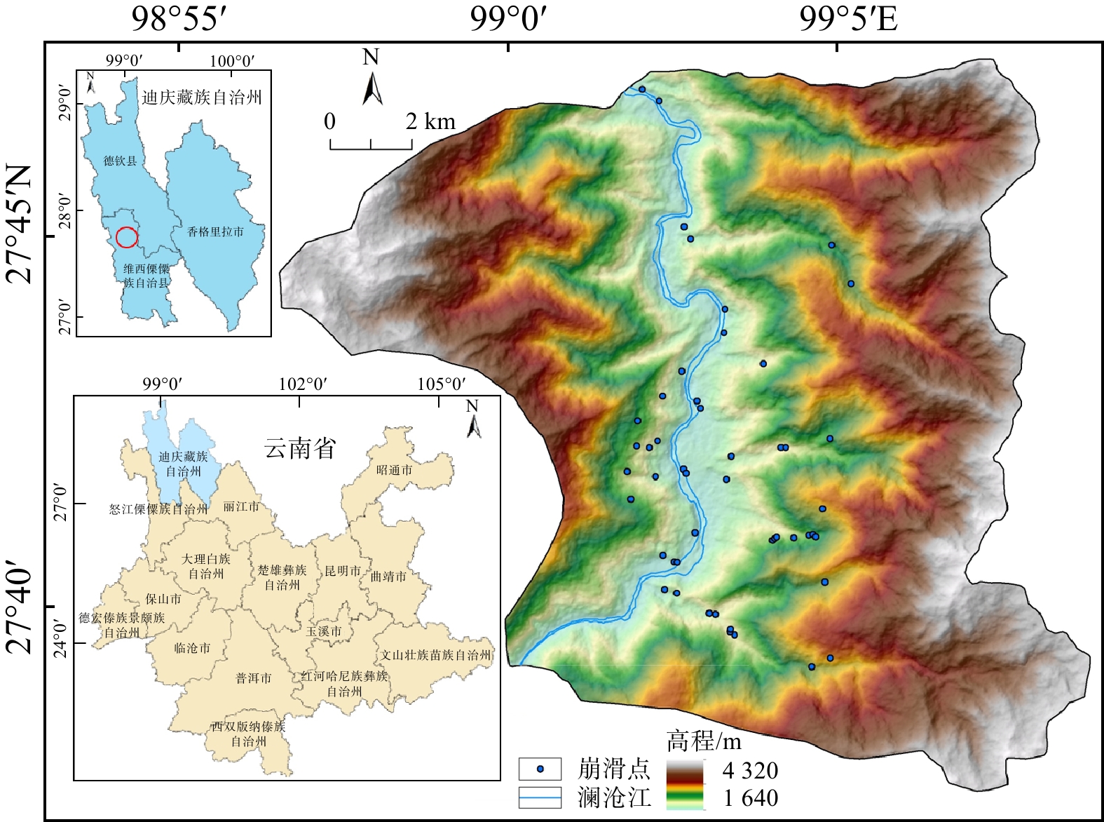
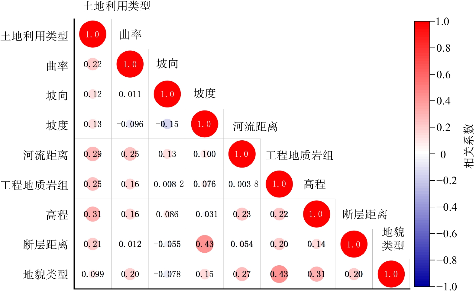
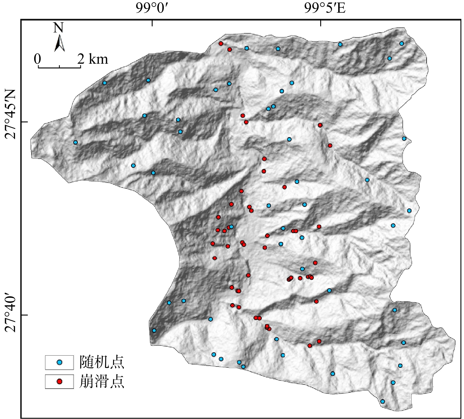
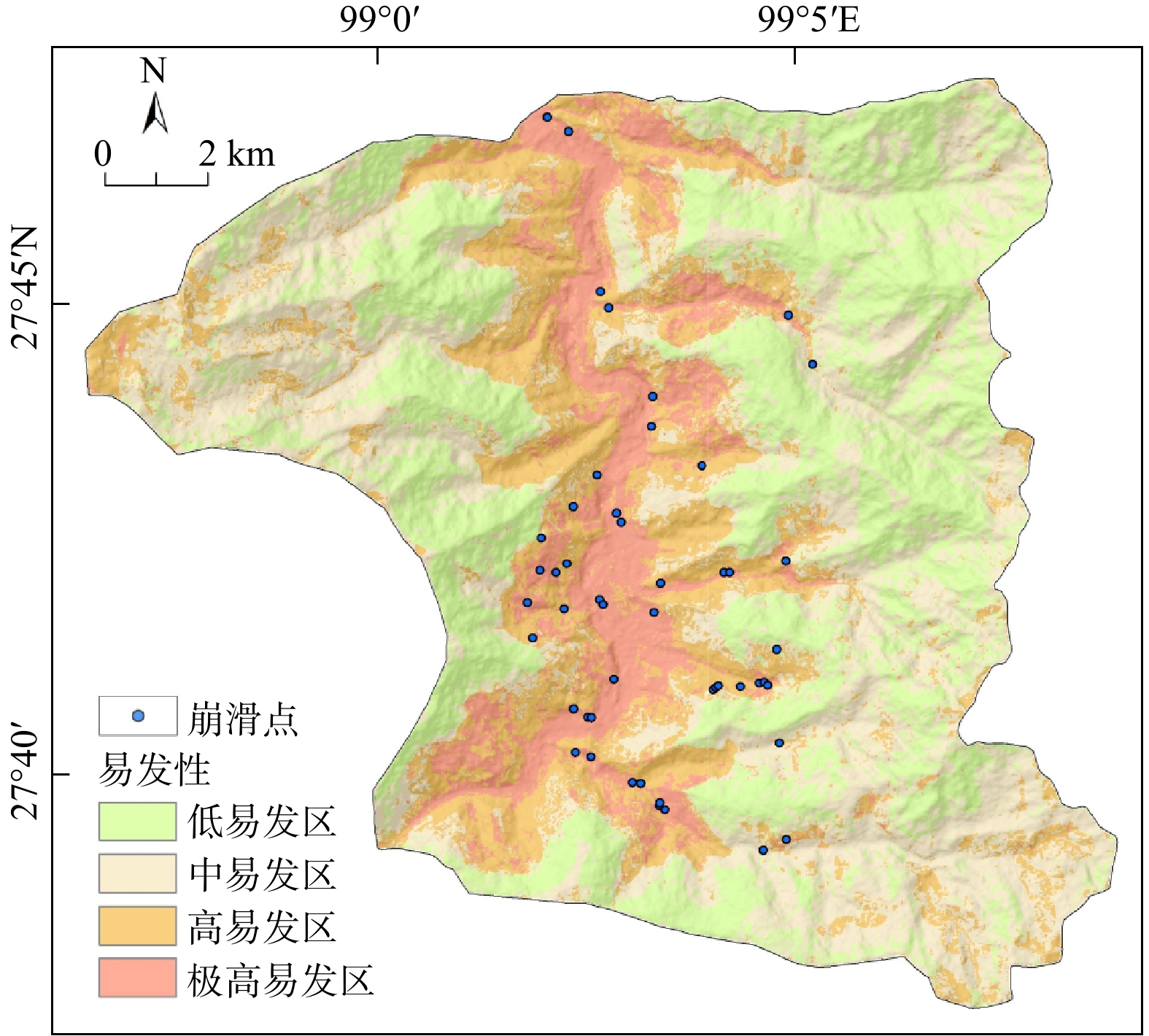
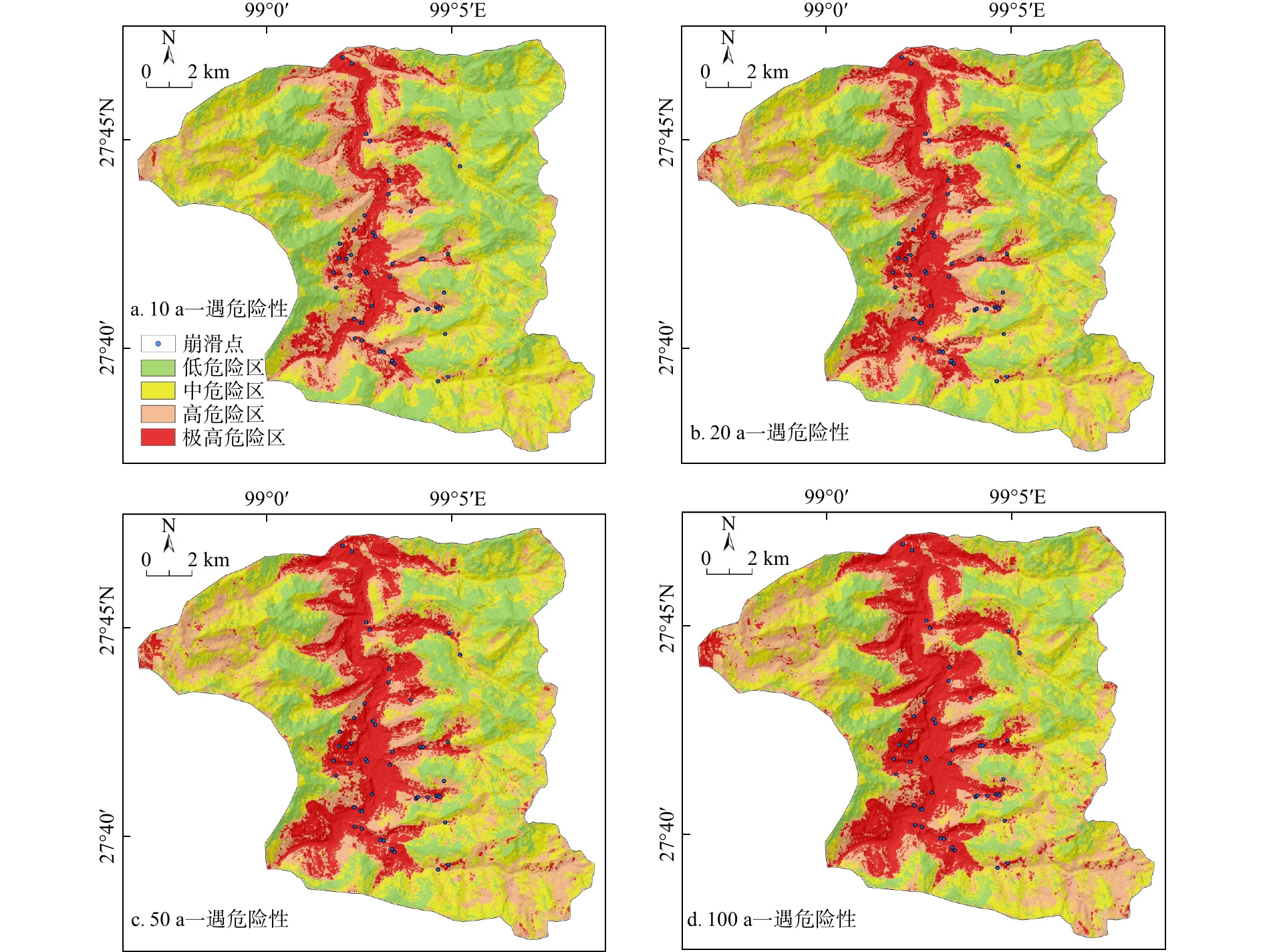
This study takes Yezhi Town, Weixi County, Yunnan Province as the study area, and the grid unit is used as the evaluation unit. Nine evaluation factors, including elevation, land use type, slope, aspect, elevation, landform type, engineering geological rock group, land use type, distance from river, distance from fault, and curvature were selected. The random forest algorithm and weighted information method were used to analyze the weight of evaluation factors, and a susceptibility evaluation was also made. Based on this, rainfall was selected as the risk assessment factor. By calculating and predicting the rainfall in the study area with Pearson Ⅲ curve, rainfall in the study area was predicted for every 10 years, 20 years, 50 years, and 100 years, and a risk assessment was obtained.
According to statistics, the susceptibility assessment results are divided into four levels using the natural discontinuity method: low, medium, high, and extremely high-susceptibility areas, which account for 32.80%, 34.02%, 21.96%, and 11.22% of the study area respectively. The ROC curves were used to verify the accuracy, and the
By comparing the actual investigation situation, the landslide and collapse risk assessment results under different rainfall conditions are highly consistent with the actual situation. This study provides a basis for reasonable disaster prevention and mitigation, as well as risk avoidance and relocation.

| [1] |
黄鑫,吴珍云,丁德建,等. 基于信息量-逻辑回归模型的江西省婺源县地质灾害易发性评价[J]. 东华理工大学学报(自然科学版),2023,46(3):259-268. doi: 10.3969/j.issn.1674-3504.2023.03.006
HUANG X,WU Z Y,DING D J,et al. Geological hazard susceptibility evaluation of Wuyuan County in Jiangxi Province based on information-logistic regression model[J]. Journal of East China University of Technology(Natural Science),2023,46(3):259-268. (in Chinese with English abstract doi: 10.3969/j.issn.1674-3504.2023.03.006
|
| [2] |
崔玉龙,朱路路,徐敏,等. 基于环境因子优化TSES法选择负样本及其在滑坡易发性评价中的应用[J]. 地质科技通报,2024,43(3):192-199.
CHUI Y L,ZHU L L,XU M,et al. Optimizing TSES method based on the environmental factors to select negative samples and its application in landslide susceptibility evalution[J]. Bulletin of Geological Science and Technology,2024,43(3):192-199. (in Chinese with English abstract
|
| [3] |
王璇,师芸,陈浩. CF耦合LR模型的地质灾害易发性评价[J]. 测绘通报,2022(11):112-117.
WANG X,SHI Y,CHEN H. Evaluation of geological hazard susceptibility based on certainty factors and coupling logistic regression[J]. Surveying and Mapping Bulletin,2022(11):112-117.
|
| [4] |
林荣福,刘纪平,徐胜华,等. 随机森林赋权信息量的滑坡易发性评价方法[J]. 测绘科学,2020,45(12):131-138.
LIN R F,LIU J P,XU S H,et al. Landslide susceptibility evaluation method of stochastic forest weighted information[J]. Surveying and Mapping Science,2020,45(12):131-138 .
|
| [5] |
郭佳,赵之星,刘志奇,等. 结合信息量与AHP模型的阳泉市矿区地质灾害风险评价[J]. 测绘通报,2022(11):101-105.
GUO J,ZHAO Z X,LIU Z Q,et al. Geological hazard risk assessment of Yangquan mining area combined with information content and AHP model[J]. Surveying and Mapping Bulletin,2022(11):101-105. (in Chinese with English abstract
|
| [6] |
严明,谢婉丽,何亚南,等. 基于极值降雨假设法的城镇地质灾害风险性评价耦合模型研究:以安康市岚皋县官元镇为例[J]. 灾害学,2023,38(4):219-227.
YAN M,XIE W L,HE Y N,et al. Research on coupling model of urban geological hazard risk assessment based on extreme rainfall scenarios:A case study of Guanyuan Town,Langao County,Ankang City[J]. Science of Disaster,2023,38(4):219-227. (in Chinese with English abstract
|
| [7] |
范雅婕,范宣梅,方成勇. 基于栅格最大值法的县域综合地质灾害建模[J]. 地质科技通报,2022,41(2):197-208.
FAN Y J,FAN X M,FANG C Y,Modeling of county comprehensive geological hazards based on grid maximum method[J]. Bulletin of Geological Science and Technology,2022,41(2):197-208. (in Chinese with English abstract
|
| [8] |
温鑫,范宣梅,陈兰,等. 基于信息量模型的地质灾害易发性评价:以川东南古蔺县为例[J]. 地质科技通报,2022,41(2):290-299.
WEN X,FAN X M,CHEN L,et al. Evaluation of geological hazard susceptibility based on information quantity model:Taking Gulin County,southeastern Sichuan as an example[J]. Bulletin of Geological Science and Technology,2022,41(2):290-299. (in Chinese with English abstract
|
| [9] |
BI X J,QIANG F,LEI H,et al. Analysis and evaluation of extreme rainfall trends and geological hazards risk in the lower Jinshajiang River[J]. Applied Sciences,2023,13(6):4021. doi: 10.3390/app13064021
|
| [10] |
盛逸凡,李远耀,徐勇,等. 基于有效降雨强度和逻辑回归的降雨型滑坡预测模型[J]. 水文地质工程地质,2019,46(1):156-162.
SHENG Y F,LI Y Y,XU Y,et al. Rainfall landslide prediction model based on effective rainfall intensity and logistic regression[J]. Hydrogeology Engineering Geology,2019,46(1):156-162 . (in Chinese with English abstract
|
| [11] |
姬永涛,王鲜,郝业,等. 基于斜坡单元的陕西省城镇地质灾害风险调查评价:以西安市蒋村街道为例[J]. 灾害学,2022,37(4):211-219. doi: 10.3969/j.issn.1000-811X.2022.04.032
JI Y T,WANG X,HAO Y,et al. Investigation and evaluation of urban geological hazard risk based on slope unit in Shaanxi Province:A case study of Jiangcun Street in Xi'an City[J]. Science of Disaster,2022,37(4):211-219. (in Chinese with English abstract doi: 10.3969/j.issn.1000-811X.2022.04.032
|
| [12] |
马增. 基于皮尔逊Ⅲ型曲线对科米卡矿区的降雨量计算[J]. 采矿技术,2019,19(3):141-142. doi: 10.3969/j.issn.1671-2900.2019.03.046
MA Z. Rainfall calculation in Comica mining area based on Pearson type III curve[J]. Mining Technology,2019,19(3):141-142. (in Chinese) doi: 10.3969/j.issn.1671-2900.2019.03.046
|
| [13] |
SARMA P C,DEY A,KRISHNA M A. Influence of digital elevation models on the simulation of rainfall-induced landslides in the hillslopes of Guwahati,India[J]. Engineering Geology,2020,268:105523.
|
| [14] |
QIANG Z,HU J,PENG C,et al. A new approach to assess landslide susceptibility based on slope failure mechanisms[J]. Catena,2021,204:105388. doi: 10.1016/j.catena.2021.105388
|
| [15] |
XIAOYI W,YUANBAO S,WEI C,et al. Analysis of geological hazard susceptibility of landslides in muli county based on random forest algorithm[J]. Sustainability,2023,15(5):4328. doi: 10.3390/su15054328
|
| [16] |
方匡南,吴见彬,朱建平,等. 随机森林方法研究综述[J]. 统计与信息论坛,2011,26(3):32-38. doi: 10.3969/j.issn.1007-3116.2011.03.006
FANG K N,WU J B,ZHU J P,et al. A review of random forest methods[J]. Statistics and Information Forum,2011,26(3):32-38. (in Chinese with English abstract doi: 10.3969/j.issn.1007-3116.2011.03.006
|
| [17] |
刘艳辉,黄俊宝,肖锐铧,等. 基于随机森林的福建省区域滑坡灾害预警模型研究[J]. 工程地质学报,2022,30(3):944-955.
LIU Y H,HUANG J B,XIAO R H,et al. Research on regional landslide hazard warning model based on random forest in Fujian Province[J]. Journal of Engineering Geology,2022,30(3):944-955. (in Chinese with English abstract
|
| [18] |
杨硕,李德营,严亮轩,等. 基于随机森林模型的乌江高陡岸坡滑坡地质灾害易发性评价[J]. 安全与环境工程,2021,28(4):131-138.
YANG S,LI D Y,YAN L X,et al. Evaluation of geological hazard susceptibility of high and steep bank slope of Wujiang River based on random forest model[J]. Safety and Environmental Engineering,2021,28(4):131-138. (in Chinese with English abstract
|
| [19] |
吴润泽,胡旭东,梅红波,等. 基于随机森林的滑坡空间易发性评价:以三峡库区湖北段为例[J]. 地球科学,2021,46(1):321-330.
WU R Z,HU X D,MEI H B,et al. Spatial vulnerability assessment of landslides based on random forest:A case study of the Hubei section of the Three Gorges Reservoir area[J]. Earth Science,2021,46(1):321-330. (in Chinese with English abstract
|
| [20] |
何佳君. 基于时序InSAR技术的金沙江上游滑坡早期识别与易发性研究[D]. 南昌:东华理工大学,2022.
HE J J. Early identification and susceptibility of landslides in the upper reaches of Jinsha River based on time series InSAR technology[D]. Nanchang:East China University of Technology,2022. (in Chinese with English abstract
|
| [21] |
盖侨侨,孙倩,张宁,等. 融合时序InSAR形变的白银市地质灾害易发性评价[J]. 武汉大学学报(信息科学版),2024,49(8):1434-1443.
GAI Q Q,SUN Q,ZHANG N,et al. Geological hazard susceptibility evaluation of Baiyin City based on time-series InSAR deformation[J]. Geomatic and Information Science of Wuhan University,2024,49(8):1434-1443. (in Chinese with English abstract
|
| [22] |
于成龙. 和龙市典型地质灾害风险性区划与地质环境承载力综合评价研究[D]. 长春:吉林大学,2021.
YU C L. Study on risk regionalization of typical geological hazards and comprehensive evaluation of geological environment carrying capacity in Helong City[D]. Changchun:Jilin University,2021. (in Chinese with English abstract
|
| [23] |
刘帅,朱杰勇,杨得虎,等. 不同降雨工况条件下的崩滑地质灾害危险性评价[J]. 地质科技通报,2024,43(2):253-267.
LIU S,ZHU J Y,YANG D H,et al. Geological hazard risk assessment of collapse and landslide under different rainfall conditions[J]. Bulletin of Geological Science and Technology,2024,43(2):253-267. (in Chinese with English abstract
|
| [24] |
郑迎凯,陈建国,王成彬,等. 确定性系数与随机森林模型在云南芒市滑坡易发性评价中的应用[J]. 地质科技通报,2020,39(6):131-144.
ZHENG Y K,CHEN J G,WANG C B,et al. Application of deterministic coefficient and random forest model to landslide susceptibility assessment in Mangshi,Yunnan Province[J],Bulletin of Geological Science and Technology,2020,39(6):131-144. (in Chinese with English abstract
|
Copyright © 2010Editorial Department of Bulletin of Geological Science and Technology

Supported by:
Beijing Renhe Information Technology Co., Ltd.


 DownLoad: