| Citation: | SONG Shunyue,LI Shuiping,WANG Xin,et al. GNSS imaging analysis of vertical deformation in Australian continental crust[J]. Bulletin of Geological Science and Technology,2025,44(1):298-307 doi: 10.19509/j.cnki.dzkq.tb20230487

|
In the study of vertical crustal deformation, the GNSS technique and InSAR technique have insufficient spatial and temporal resolutions, respectively. To better explore the continuous spatial characteristics of crustal vertical deformation, images of crustal vertical motion can be generated based on discrete GNSS station velocities; thus, the continuous spatial characteristics of crustal vertical motion can be directly revealed.
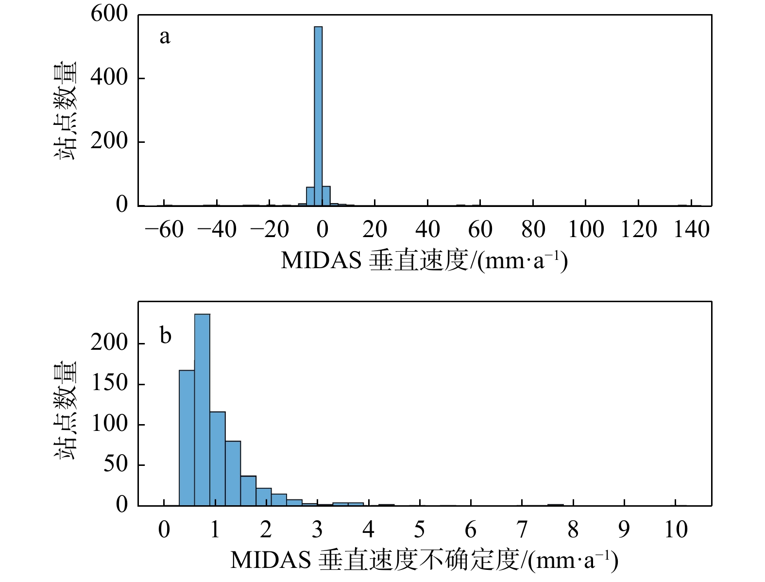
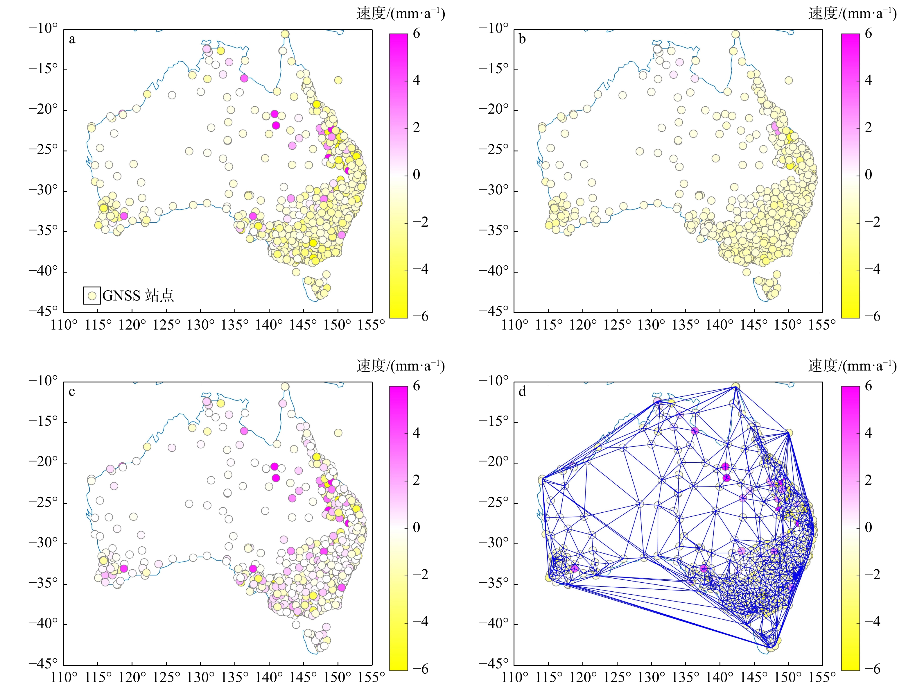
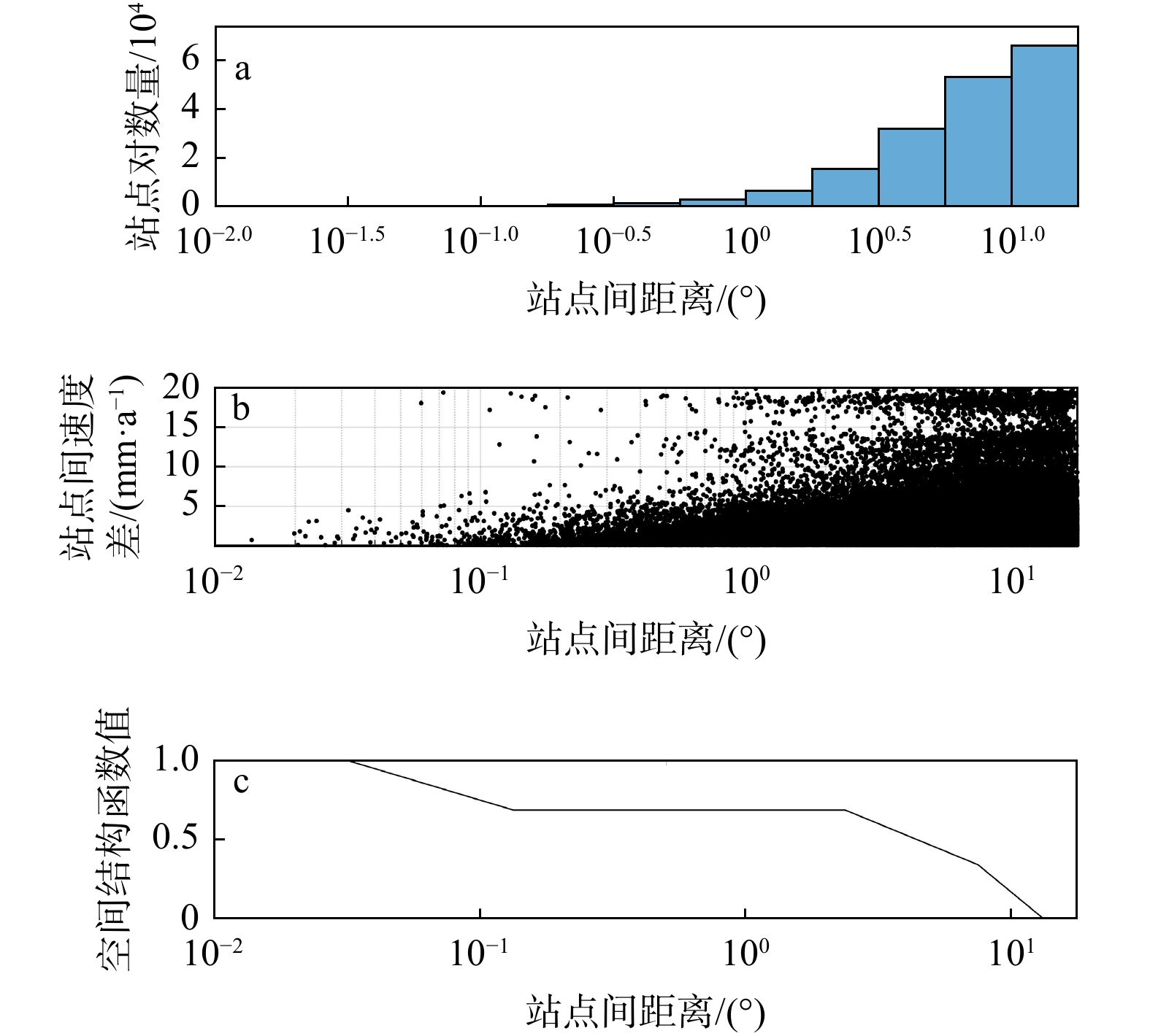
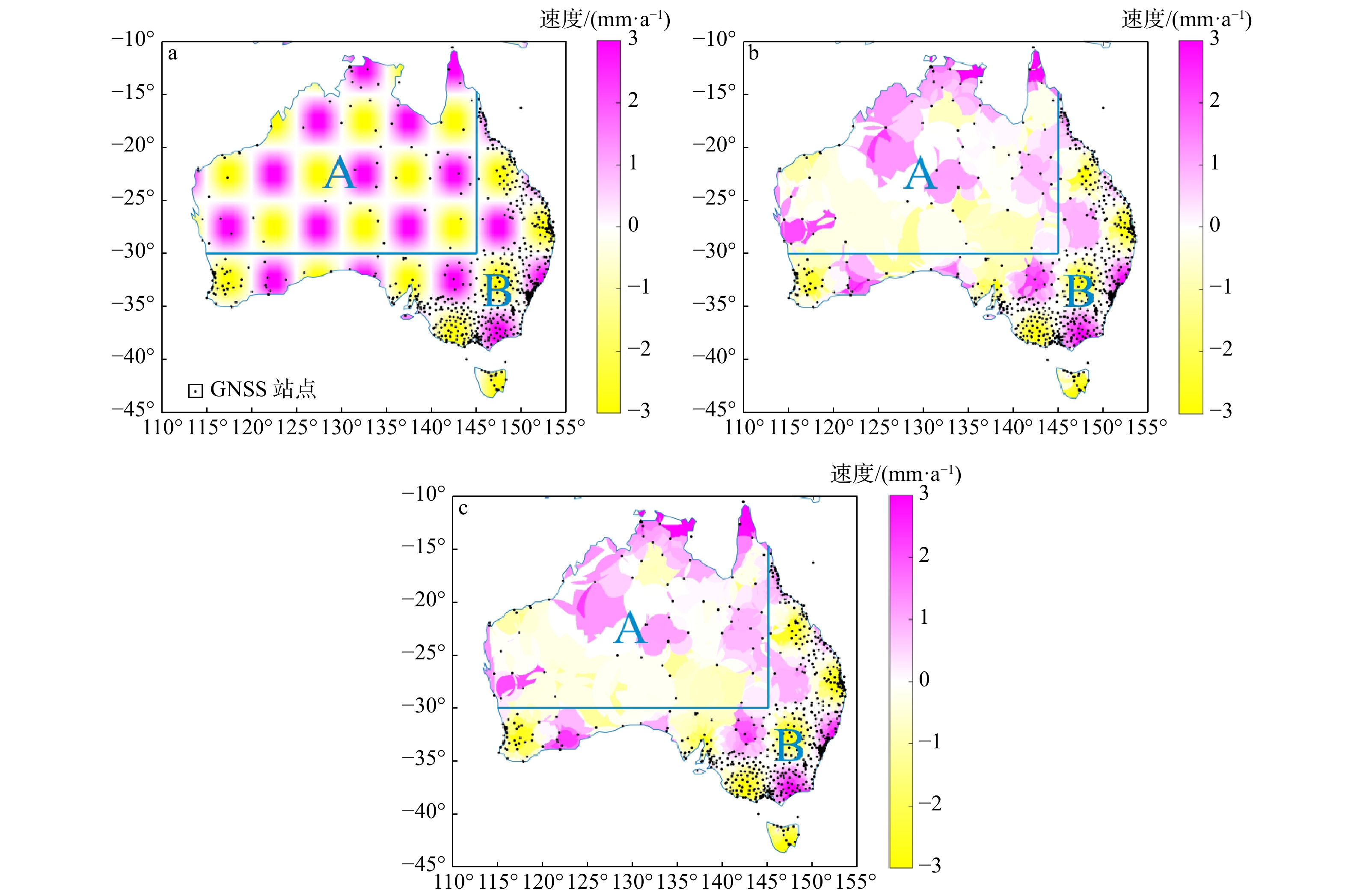
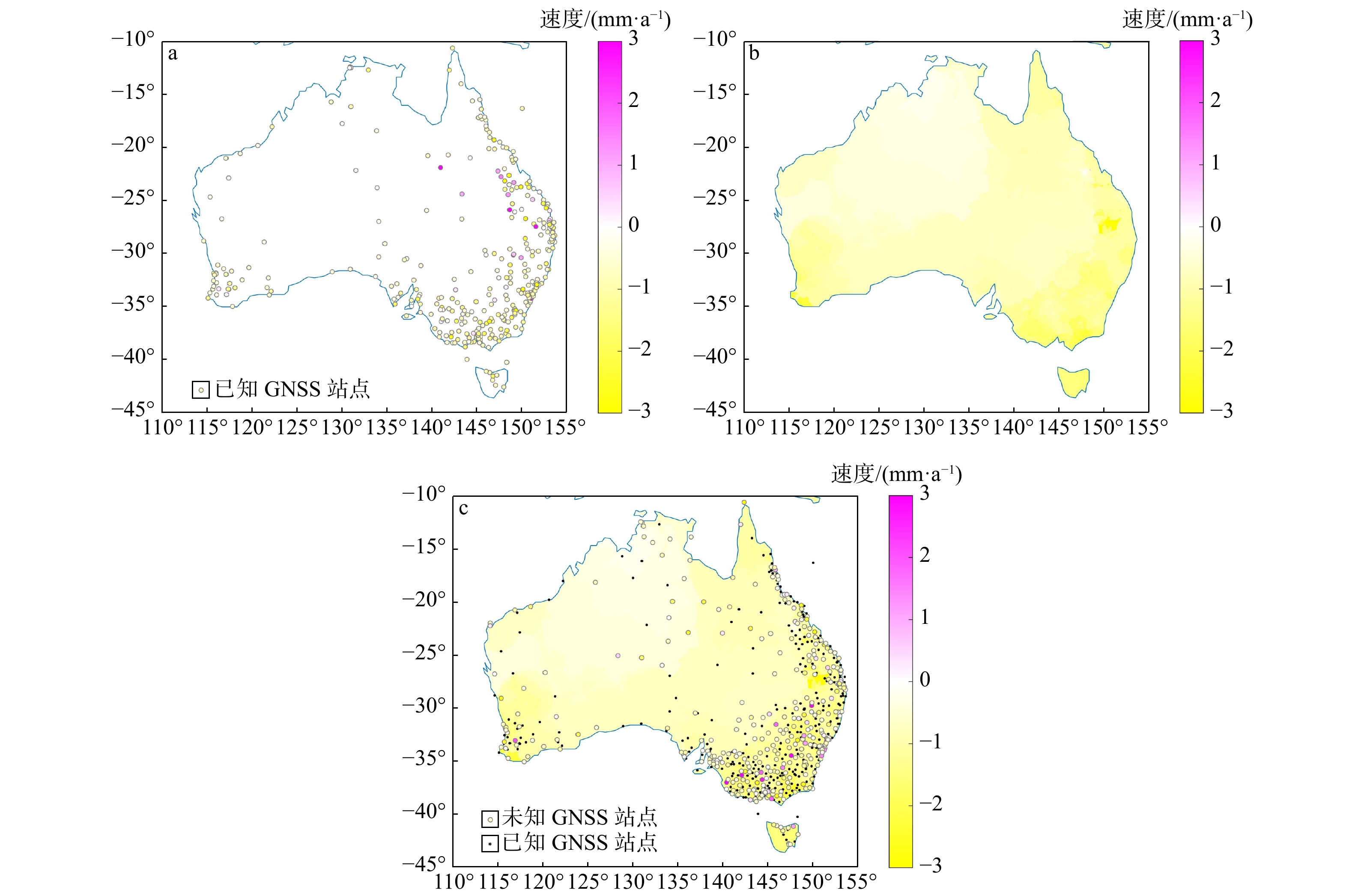
In this work, the vertical deformation of the Australian continental crust is studied via GNSS imaging. GNSS imaging was first proposed by Professor Hammond of the Nevada Geodesy Laboratory, who used this method to obtain high-resolution images of crustal vertical deformation (GNSS images) in California and Nevada, USA. As a method to obtain images of continuous crustal vertical deformation with the help of image processing technology, it can automatically eliminate the influence of abnormal observations in the study area and reveal the spatiotemporal variation characteristics of crustal vertical deformation. First, the coordinate time series of the GNSS station in Australia are used to obtain the station velocities and uncertainties via a robust nonparametric estimation method, namely, the median interannual difference adjusted for skewness (MIDAS); second, the relationships between stations with the spatial structure function (SSF) are constructed; third, a median spatial filter (MSF) is constructed and applied to eliminate velocity outliers and enhance regional common characteristics; finally, the velocity field is densified using image processing technology, and spatially continuous GNSS images in the study areas are generated. In addition, checkerboard tests and cross-checks are carried out to verify the reasonability of GNSS imaging and the reliability of the GNSS images generated with the stations in these areas. Moreover, when the velocities before and after MSF were compared, the necessity of MSF in GNSS imaging was verified, and the causes of oversmoothing and the formation of arcuate abrupt boundaries were analyzed.
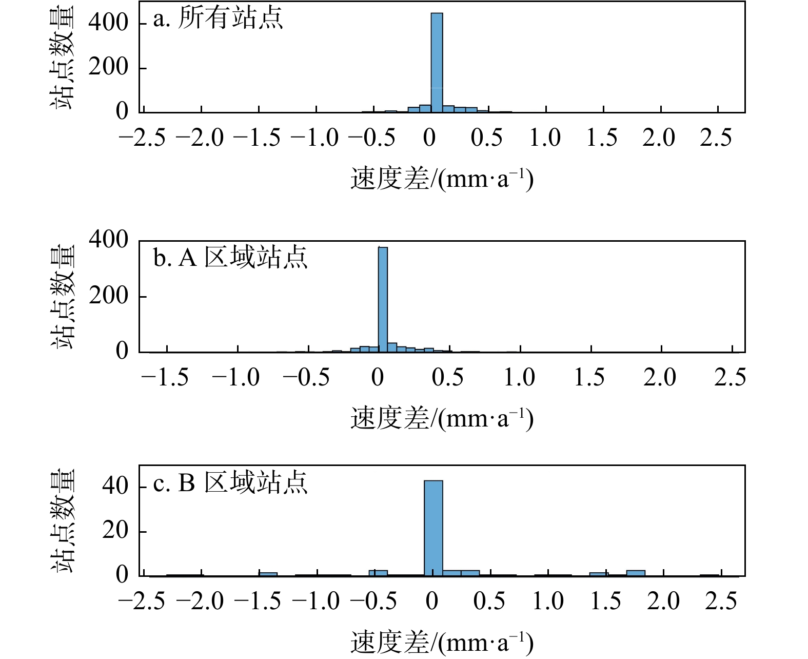
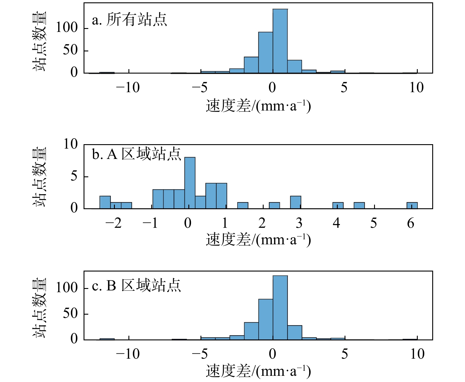
The findings of this study indicated that 98% of the Australian continent and its surrounding regions experienced subsidence. In contrast, only certain areas in northern Australia and a small portion of eastern Australia exhibited an increase in crustal deformation. Notably, the subsidence rate in the eastern part of the region was higher than that observed in the central and western areas. This pattern aligns with certain impacts from climate-related load sources but contradicts the effects associated with glacial isostatic adjustment.The mean and median values of vertical deformation in and around Australia are −0.76 mm/a and −0.72 mm/a, respectively, and the vertical deformation ranges from −3 mm/a to 1 mm/a. Moreover, through checkerboard tests and cross-checks, we can conclude that MSF for sites can effectively eliminate some effects of gross errors and effectively reduce the problems of fragmentary pattern spots and regular circular abrupt edges in GNSS images. However, gross errors cannot be well identified with peak and mutation values in the filtering process when sites are sparse. In the filtering process, some peaks and mutation values may be eliminated, which makes the generated image too smooth.
Based on the research in this paper, it is concluded that GNSS images from the Australian continent accurately capture the overarching trends across extensive areas, demonstrating their reliability and correctness. Furthermore, these images effectively represent the temporal and spatial distribution characteristics of crustal vertical deformation. This method is helpful for studying the temporal and spatial distributions of crustal vertical deformation.

| [1] |
LARSON K M,FREYMUELLER J T,PHILIPSEN S. Global plate velocities from the Global Positioning System[J]. Journal of Geophysical Research(Solid Earth),1997,102:9961-9981.
|
| [2] |
HUANG H,MENG L S,BURGMANN R,et al. Early aftershocks and afterslip surrounding the 2015 Mw 8.4 Illapel rupture[J]. Earth and Planetary Science Letters,2017,457:282-291.
|
| [3] |
张占忠,陈富强,刘亚林,等. 基于遥感技术的嘉黎江巴变形体稳定性评价与分析[J]. 地质科技通报,2023,42(3):28-37.
ZHANG Z Z,CHEN F Q,LIU Y L,et al. Stability evaluation and analysis of the Jiangba deformed body in Jiali County based on remote sensing technology[J]. Bulletin of Geological Science and Technology,2023,42(3):28-37. (in Chinese with English abstract
|
| [4] |
董佳慧,牛瑞卿,亓梦茹,等. InSAR技术和孕灾背景指标相结合的地灾隐患识别[J]. 地质科技通报,2022,41(2):187-196.
DONG J H,NIU R Q,QI M G,et al. Identification of geological hazards based on the combination of InSAR technology and disaster background indicators[J]. Bulletin of Geological Science and Technology,2022,41(2):187-196. (in Chinese with English abstract
|
| [5] |
SHEN Z K,JACKSON D D,GE B X. Crustal deformation across and beyond the Los Aangeles Basin from geodetic measurements[J]. Journal of Geophysical Research( Solid Earth),1996,101:27957-27980.
|
| [6] |
WANG M,SHEN Z K. Present-day crustal deformation of continental China derived from GNSS and its tectonic implications[J]. Journal of Geophysical Research(Solid Earth),2020,125:e2019JB018774.
|
| [7] |
谭凯,赵斌,张彩红,等. GPS和InSAR同震形变约束的尼泊尔Mw7.9和Mw7.3地震破裂滑动分布[J]. 地球物理学报,2016,59(6):2080-2093. doi: 10.6038/cjg20160614
TAN K,ZHAO B,ZHANG C H,et al. Rupture models of the Nepal Mw7.9 earthquake and Mw7.3 aftrershock constrained by GPS and InSAR coseismic deformations[J]. Chinese Journal of Geophysics,2016,59(6):2080-2093. (in Chinese with English abstract doi: 10.6038/cjg20160614
|
| [8] |
许才军,何平,温扬茂,等. InSAR技术及应用研究进展[J]. 测绘地理信息,2015,40(2):1-9.
XU C J,HE P,WEN Y M,et al. Recent advances InSAR interferometry and its applications[J]. Journal of Geomatics,2015,40(2):1-9. (in Chinese with English abstract
|
| [9] |
黄宇,杨荣森,韩晓东,等. 基于定向半变异函数的裂隙网络空间变异性分析[J]. 地质科技通报,2023,42(2):186-193.
HUANG Y,YANG R S,HAN X D,et al. Analysis of the spatial variability on a fracture network based on an oriented semivariogram[J]. Bulletin of Geological Science and Technology,2023,42(2):186-193. (in Chinese with English abstract
|
| [10] |
HAMMOND W C,BLEWITT G,KREEMER C. GPS imaging of vertical land motion in California and Nevada:Implications for Sierra Nevada uplift[J]. Journal of Geophysical Research( Solid Earth),2016,121:7681-7703.
|
| [11] |
PAN Y,HAMMOND W C,DING H,et al. GPS imaging of vertical bedrock displacements:Quantification of two-dimensional vertical crustal deformation in China[J]. Journal of Geophysical Research(Solid Earth),2021,126:e2020JB020951.
|
| [12] |
XIANG Y,YUE J,LIU G,et al. Characterizing the spatial patterns of vertical crustal deformations over the South American Continent based on GNSS imaging[J]. Pure and Applied Geophysics,2022,179:3569-3587.
|
| [13] |
周晓慧,杨艺林,姜卫平,等. GNSS影像及其时空特征初探[J]. 地球物理学报,2020,63(1):155-171. doi: 10.6038/cjg2020M0473
ZHOU X H,YANG Y L,JIANG W P,et al. Preliminary spatial temporal pattern of vertical deformation revealed by GNSS imaging[J]. Chinese Journal of Geophysics,2020,63(1):155-171. (in Chinese with English abstract doi: 10.6038/cjg2020M0473
|
| [14] |
BLEWITT G,KREEMER C,HAMMOND W C,et al. MIDAS robust trend estimator for accurate GPS station velocities without step detection[J]. Journal of Geophysical Research(Solid Earth),2016,121:2054-2068.
|
| [15] |
THEIL H. A rank-invariant method of linear and polynomial regression analysis[J]. Indagationes Mathematicae,1950,12:85-91.
|
| [16] |
SEN P K. Estimates of the regression coefficient based on Kendall's tau[J]. American Statistical Association,1968,63:1379-1389. doi: 10.1080/01621459.1968.10480934
|
| [17] |
DELAUNAY B. Sur la sphère vide[J]. Bulletin of the Academy of Sciences of the USSR,1934,7:793-800.
|
| [18] |
RIDDELL A R,KING M A,WATSON C S. Present-day vertical land motion of Australia from GPS observations and geophysical models[J]. Journal of Geophysical Research(Solid Earth),2020,125:e2019JB018034.
|
| [19] |
HAMMOND W C,BLEWITT G,KREEMER C,et al. GPS imaging of global vertical land motion for studies of sea level rise[J]. Journal of Geophysical Research(Solid Earth),2021,126:e2021JB022355.
|
Copyright © 2010Editorial Department of Bulletin of Geological Science and Technology

Supported by:
Beijing Renhe Information Technology Co., Ltd.


 DownLoad: