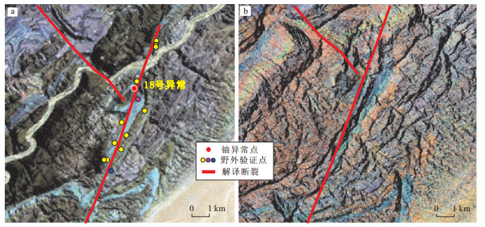
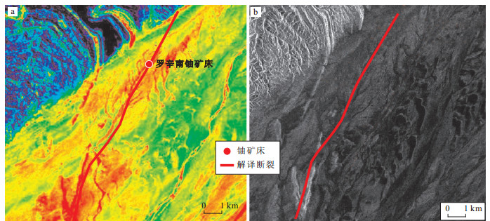
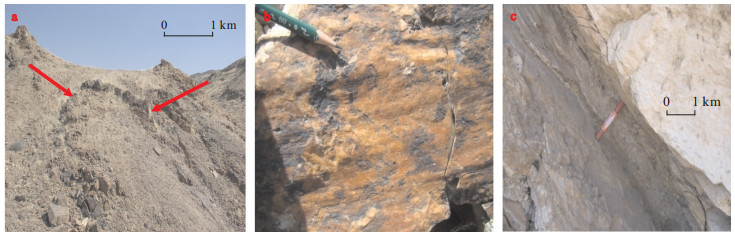
2020 Vol. 39, No. 5

Display Method:
CONTENTS
2020, 39(5)
Abstract:
Application of landslide progressive failure mechanical model based on the critical stress state
Wu Yiping, Lu Lier, Xue Yang
2020, 39(5): 1-7. doi: 10.19509/j.cnki.dzkq.2020.0501
Abstract:
According to the physical significance of the slice method of slope, the strength softening behavior of the geo-material is characterized by strength reduction coefficient. The unbalanced thrust method hypothesis is generalized. And during the same state of peak shear stress and strain, the progressive failure process of landslide is simulated by using the perfect elastic-plastic model (PEPM) and the complete process shear stress-strain constitutive model (CPCM). Then, a determination method with critical stress state is proposed, and the partial strength reduction method (PSRM) is employed. The unbalance thrust force and driving sliding force become greater and greater, and the frictional resistance gets smaller and smaller during the deformation failure process. Taking the Daochicun landslide located in Enshi, Hubei Province as an example, the evolution characteristics in progressive failure process are revealed by the proposed method with three sorts of numerical simulations (PSRM, PEPM and CPCM). Results show that:the proposed generalized slice block method with the three numerical simulations can describe the progressive failure process of the landslide, the factor of safety of the PSRM and PEPM are more than that of the CPCM.
Calculation method and application of internal force of anchor pile based on "three-stage method"
Su Aijun, Gan Zhaowen, Song Hongbin, Lu Zhichun
2020, 39(5): 8-16. doi: 10.19509/j.cnki.dzkq.2020.0502
Abstract:
In view of the fact that the bottom surface of the loaded section and the top surface of the embedded section are not in the same horizontal plane due to geological conditions, topography and other reasons, this paper classifies this section as a secondary load section and derives the formula of designed load calculation and distribution about this secondary load section. As well as general formulas for the calculation of internal force, deflection of cantilever piles, anchor cable piles under elastic foundation beam and cantilever beam models. Taking the prestressed anchor piles of the reservoir bank protection project at Jiaojiawan resettlement site in Badong County as an example, the influence of the internal force and deflection of the anti-slide piles in the secondary load section is studied. The results show that the traditional calculation method that ignoring the effect of the earth pressure after the secondary load will make the calculation result of the pile bending moment smaller and leads to insufficient reinforcement of the pile, which really has a safety risk. Taking the number and position of the anchor cables as the control variables, the influence on the internal force and deflection of the prestressed anchor cables is studied, and it is proposed that the prestressed anchor cables can effectively reduce the construction cost of anti-slide piles; increasing the number of prestressed anchor cables which is beneficial to adjust the internal force distribution of anti-slide piles, and multi-row anchor cables should be given priority in the design.
Intelligent identification method for rock discontinuities properties by digital borehole panoramic images
Song Kun, Sun Chi, An Dong, Yi Zheng
2020, 39(5): 17-22. doi: 10.19509/j.cnki.dzkq.2020.0503
Abstract:
Digital borehole panoramic imaging technique is the main method to identify the discontinuities properties of deep rock mass. The traditional identification method mainly relies on manual operation, therefore the results are artificial, subjective and inaccurate. A new intelligent identification method is proposed considering gray level distribution of rock discontinuities for the digital borehole panoramic imaging technique. The panoramic images are firstly pre-processed by graying and noise reduction, and positioned the joints by the eigenvalue, D, to obtain the joints region images. The joints images are processed after edge detection, threshold partition and morphology processing. Finally, intelligent identification of discontinuities characteristics are realized by joints edge curve fitting and mathematical calculation, which are dip direction, dip and aperture. Compared with a traditional artificial method, the proposed technique is more accurate and objective, and more efficient in batch images identification.
Three-dimensional optimization method for the anchorage direction angle of plane sliding in rock slope
An Cailong, Liang Ye, Wang Liangqing, Sun Zihao, Deng Shan, Zhu Linfeng, Jiang Yaofei, Tian Jianlin
2020, 39(5): 23-30. doi: 10.19509/j.cnki.dzkq.2020.0504
Abstract:
The calculation method of the optimal anchorage direction angle of the common plane sliding in rock slope is studied. The maximum anti-sliding increment that unit length of the free segment of anchor cable can provide is considered as target control variable and the characteristic parameters of slope surface and sliding surface and the anchor cable design parameters treated as the optimization control independent variables.The anchorage force of the anchor cable is decomposed through the system of linear equations obtained by means of coordinate system transformation, and the optimal formula for the length of the free segment of the anchor cable is established from the 3D model of anchor cable supporting. Then a new three-dimensional optimization calculation equation for the anchorage direction angle of the anchor cable is derived. Based on the equation, the fmincon function in MATLAB is used to optimize the anchorage direction angle when the anchor cable reinforcement direction has no restrictions. Finally, through the combination of sensitivity analysis of anchorage direction angle and engineering example analysis, the validity and advancement of the calculation method of the optimal anchorage direction angle recommended in this paper are proved. The new method solves the problem of solving the optimum anchorage direction angle effectively when the strike direction of slope surface and sliding surface are at an angle, which can further improve the profit of the anchoring of the anchor cable and reduce the support cost of the slope.
Structure failure and rehabilitation technologies of the cable tunnel
Li Ming, He Lei, Ma Baosong, Wang Tianyu, Zhu Zihao
2020, 39(5): 31-37. doi: 10.19509/j.cnki.dzkq.2020.0505
Abstract:
The urban underground municipal tunnels such as cable tunnel and underground pipeline are usually affected complex load conditions and working environment, and are also highly susceptible to human engineering activities, and thus problems or even failures occur during their design life. Although such failures, not only have caused huge casualties and property losses but also aroused great social attention, the structural failure and rehabilitation method of the cable tunnel have been rarely studied at present. This paper mainly focused on the failure of the cable tunnel's main structure. The damage form and hazard area of the failure are studied based on the numerical study, case investigation, and reference to structural characteristics of the underground pipelines. The results showed that most of the structural damage was concentrated in the hazard area of the failure. Moreover, different structural rehabilitation technologies were compared and analyzed in terms of the scope of application, cost, and the effect of rehabilitation, and the trenchless spraying rehabilitation method was found to have good applicability and workability, and it was safe and efficient. Therefore, references could be provided for solving the problems that might happen in the cable tunnel structure in China by combining the research on relevant structural failure and rehabilitation methods.
Influence on the strength of soil-rock mixture made by the rock block orientation features based on numerical experiment
Lin Chengyuan, Tang Huiming, Wang Dingjian, Li Tianjun, Wen Tao
2020, 39(5): 38-46. doi: 10.19509/j.cnki.dzkq.2020.0519
Abstract:
This paper is to explore the influence on the strength of soil-rock mixture made by the rock block orientation features based on numerical experiment.The 2-D Elliptic Block Collection Stochastic Model (EBCS2D) was developed and a series of bia-axial compression numerical tests were conducted.The result indicates that the strength of soil-rock mixture is affected by the rock block orientation features.This effect is highly related to the block proportion.The results of numerical experiments are fitting in an anisotropic yield surface equation, which proves the equation is suitable on the soil-rock mixture, describing the impact of the block proportion and orientation.The soil-rock interactive unit is introduced to explain the mechanism and result.The soil-rock mixture strength changing patterns to the block orientation features are dominated by isolated effect or clustered effect.The dominating effects vary with the block proportion.
Rock constitutive model based on damage partition and unified strength theory
Shen Peiwu, Tang Huiming, Ning Yibing, An Pengjü, Zhang Bocheng, He Cheng
2020, 39(5): 47-54. doi: 10.19509/j.cnki.dzkq.2020.0516
Abstract:
Almost all the rocks in a nature internally contain damage to a certain extent. The proceeding of damage evolution will lead unstability of rocks because of crack coalescence. In this paper, the rocks are divided into three parts, e.g., the undamaged part, the closed crack part and the open crack part. Then, a compatibility analysis of deformation was conducted, and the damage constitutive model and the damage evolution model were proposed based on unified strength theory and statistical damage theory. The models were verified by tested results of triaxial compression test of purple mudstone in Badong formation. Finally, the models were applied to analyse the damaged depth of one anticlinal bedded rock slope. Results indicate that the damage constitutive model corresponds with tested results, e.g., the triaxial stress-strain feature. Also, the damage evolution model well reflects the damage process of samples and the model parameters process distinct physical meanings. Besides, the modified damaged depth model of anticlinal bedded rock slope is more conservative and will bring safety to geotechnical engineering design.
Mechanism and laws of deterioration and damage of gneisses under cyclic loading
Yang Long, Shi Xiaoyong, Chen Qian, Wei Yunjie, Zhang Ming, Lü Wentao
2020, 39(5): 55-60. doi: 10.19509/j.cnki.dzkq.2020.0517
Abstract:
The collapses and landslides of gneiss in Taxian area of Xinjiang are mainly caused by the deterioration of rock mass under the long-term circulation of seismic force. In order to reveal the mechanism of deterioration and damage of gneiss under earthquake in Taxian area, constant amplitude cyclic loading tests and triaxial compression tests were carried out on gneiss samples under different stress levels in this paper. And the variation rules of hysteretic cycle, damping parameters and triaxial compressive strength before and after constant amplitude cyclic loading were analyzed. The results show that:the damping ratio and damping coefficient of gneiss decrease with the increase of cyclic loading and increase with the increase of stress level; after cyclic loading, the triaxial compressive strength of gneiss decreases significantly, and the higher the stress level is, the greater the reduction range is; in addition, the friction of mineral particles in gneiss, the opening and closing of primary micro-fissures and pores, and the generation and development of secondary fissures are the main mechanisms leading to their deterioration and damage. In short, under the long-term earthquake force, the mechanical property of gneiss in the study area has been reduced due to internal deterioration and damage, which is one of the main reasons for the extensive development of large-scale collapses, landslides and other geological disasters in this area.
Fractal geometry study on uniaxial compression fracture characteristics of sandstone subjected to freeze-thaw cycles
Zhou Shengtao, Fang Wen, Jiang Nan, Hu Meng, Luo Xuedong
2020, 39(5): 61-68. doi: 10.19509/j.cnki.dzkq.2020.0518
Abstract:
The mechanical properties of rocks in cold regions are often affected by freeze-thaw cycles and loads. The uniaxial compression fractures of rocks subjected to freeze-thaw cycles contain damage evolution information related to freeze-thaw cycles and loads. It is of great value to study the uniaxial compression fracture of freeze-thaw rocks for the rock fracture failure mechanism after freeze-thaw degradation. To study the uniaxial compression fracture morphology of freeze-thaw rock and its correlation with the macro mechanical parameters, in this paper, fractures of sandstone under the uniaxial compression and different freeze-thaw cycles are observed by photography. The fracture fractal dimension is calculated by the pixel covering method, and the relationship between the fractal dimension and the macro-mechanical parameters is discussed. The results indicate that as the number of freeze-thaw cycles increases, the uniaxial compressive strength, elastic modulus, fracture fractal dimension, and energy dissipation density decrease gradually, and the peak strain increases. There are exponential relationships between the three parameters (uniaxial compressive strength, elastic modulus and dissipated energy density) and the fracture fractal dimension. The larger the fracture fractal dimension is, the greater the three parameters are. The fractal dimension of the freeze-thaw rock fracture under the uniaxial compression can be used as an effective parameter for the mechanism analysis of rock failure in cold regions.
Sedimentary characteristics and hydrocarbon exploration potential of the upstream of the Central Canyon in the Yinggehai and Qiongdongnan Basins
Xie Yuhong
2020, 39(5): 69-78. doi: 10.19509/j.cnki.dzkq.2020.0601
Abstract:
Hydrocarbon discoveries have been mainly focused on deep water areas during the past decade. The f-irst gas field in deep water area, Lingshui 17-2, has been discovered and successfully developed in the Central Canyon system of the Qiongdongnan Basin. In order to further expand the hydrocarbon exploration, it is urgent to clarify the sedimentary characteristics in the source area of the Central Canyon and its hyrocarbon exploration prospects. Based on the integration between 3D seismic data covering the whole study area and many drillings, the stratigraphic framework is established and the formation and evolution process of the Central Canyon system is illustrated. Furthermore, the types of sedimentary system, distribution and sedimentary models in the source area of the Central Canyon are systematically summarized. Combined with the natural gas accumulation conditions and reservoir forming models in the study area, the prospect of hydrocarbon exploration in the source area of the Central Canyon is discussed. The results show that deep water channels, shelf-edge delta and channelized fan are developed in the Huangliu Formation in the source area of the Central Canyon system. The sediments from Indosinian, Red River and Hainan Island are transported to the deep water area of the basin in the form of gravity flow, and finally converge in the Central Canyon system. High quality reservoirs are developed in the axial channels, slope channels and channelized fans deposited in the source area of the Central Canyon system.Therefore, natural gas from the deep strata is expected to be migrated and accumulated into large scale gas filed along mud-fluid diapirs.
Geological modeling method of gravel braided river outcrop: A case from the 35 section of outcrop area of Heiyoushan in Karamay as an example
Shi Le, Yuan Shuwu, Wang Hui, Li Xiang, Wu Xiaojun
2020, 39(5): 79-86. doi: 10.19509/j.cnki.dzkq.2020.0506
Abstract:
Outcrop study plays an important role in understanding underground geological conditions. The type of deposition of the same type can be described more precisely by the sedimentation law revealed by outcrops. However, it is difficult to describe the shape, scale, orientation, and scale of target body in numerical modeling.Based on the profile of black oil hill outcrop area of Karamay Oilfield, using the Composite method based on RMS, the basic object of modeling is established. The regularity of multi-period river sedimentation is evaluated and a spatial distribution model of braided river sand bodies being consistent with outcrops is established.
Controlling effects of sand body structural characteristics on oil reservoirs of Chang 81 oil layer in Jiyuan area
Qiu Xiangliang, Chen Xiaodong, Ding Li, Tan Yuhan, Huang Qiong
2020, 39(5): 87-96. doi: 10.19509/j.cnki.dzkq.2020.0507
Abstract:
As the main development strata in Jiyuan area, Chang 81 oil layer has a staggered superimposed relationship of sand bodies, which seriously affects the reservoir distribution in this area.The study on the structural characteristics of the sand bodies in Chang 81 oil layer and their control effects on reservoir distribution is carried out, which is beneficial to the continuous exploration and development in Jiyuan area. Based on the formation mechanism of sand bodies in Chang 81 oil layer, the sedimentary and logging data were combined to divide the structural types of sand bodies, and the relationship between transverse interlacing and longitudinal superposition of sand bodies was described. Further, the control effects of sand body structure on reservoir distribution were clarified. Results show that the sand body structure in Jiyuan area can be divided into four types, including superimposed box shape, toothed bell shape, isolated box shape and isolated finger shape. The superimposed-box-shape sand body has good oiliness and is the main reservoir body. The top and bottom of the toothed-bell-shape and isolated-box-shape sand body have poor oiliness, but the middle part of them has good and uniform oiliness. The isolated-finger-shape sand body's physical properties and oiliness are poorer. The sand body structure in this area is significantly related to the distribution of favorable reservoirs. Most of the superimposed-box-shape sand bodies are of type I favorable reservoir. The result can provide the basis and direction for delicate exploration and development of Chang 8 reservoir in Jiyuan area.
Significance of inclusions and fluid evolution of the porphyry-skarn copper-molybdenum deposit in Tongshankou, Daye, Hubei
He Di, Tan Jun, Liu Xiaoyang, Zhang Min, Zhao Biao, Chen Yang, Zhao Yanyan
2020, 39(5): 97-108. doi: 10.19509/j.cnki.dzkq.2020.0508
Abstract:
Magma-skarn is an important genetic type among the multi-genesis of skarns. Based on petrographic observation and thermal microscopy temperature measurement of inclusions, combined with laser Raman spectroscopy, characteristics of ore-forming fluids at the Tongshankou porphyry-skarn copper-molybdenum deposit has been studied. This study aims to provide evidence for the formation of the magma-genetic skarn and further to unveil the melt-flow conversion processes and metal enrichment mechanism of ore-forming fluids. A vast amount of crystalline and amorphous melt inclusions and melt-fluid inclusions the melt inclusions have been found in the skarn minerals, e.g. garnet in the early stage, indicating that the magma droplets could have been trapped by the early skarn minerals. These inclusions could provide essential evidence for the magmatic genesis of the early skarns. With the comparison of different types of inclusions in the skarn minerals at each stage, it is believed that the skarn is dominated by magmatic genesis in the early stage, and the hydrothermal genesis in the late stage. Moreover, the processes of melt-flow conversion mainly occur in the prograde skarn stage. Ore minerals, e.g. chalcopyrite, found in the melt inclusions through the laser Raman analysis indicate that the skarn magma is rich in ore-forming materials at the Tongshankou deposit, which could aid in the deep prospecting and exploration in this area.
Characteristics and significance of platinum-group elements (PGEs) in polymetallic nodules from CCZ, East Pacific
Qiu Zhongrong, Ma Weilin, Yang Kehong
2020, 39(5): 109-117. doi: 10.19509/j.cnki.dzkq.2020.0509
Abstract:
The major, trace and platinum-group elements (PGEs) concentration of 20 polymetallic nodules obtained during the DY-45th Cruise from Clarion-Clipperton Zone (CCZ) of East Pacific were analyzed.The results show that the polymetallic nodules in the study area are basically mixed-type, and its total PGEs contents (ΣPGE) range from77.2×10-9 to 197×10-9, with an average of 136×10-9, which is significantly lower than that of hydrogenetic nodules in sea area of Cook Island (ΣPGE=306×10-9).The chondrite-normalized PGEs patterns of our study nodules are very similar to that of hydrogenetic nodules and cobalt-rich crusts, with all being characterized by positive Pt anomalies, gradual enrichment from Os to Pt and depletion from Pt to Pd.Combined with the characteristics of PGEs distribution in seawater and previous studies, it is suggested that PGEs in nodules should be derived directly from seawater.It is found that ΣPGE of polymetallic nodules in the study area are positively correlated with Fe and negatively correlated with Mn, but are positively correlated with Mn and negatively correlated with Fe in the sea area of Cook Island, indicating that the PGEs host-phases in different genetic nodules are different.PGEs in hydrogenetic nodules may mainly occur in manganese mineral phases, while mixed type-diagenetic nodules may mainly occur in iron mineral phases and the stronger the diagenesis is, the lower the ability of nodules is to enrich PGEs.
A review of the research status of Caledonian movement stages in Sichuan Basin and surrounding areas
Zhang Haoran, Jiang Hua, Chen Zhiyong, Su Wang
2020, 39(5): 118-126. doi: 10.19509/j.cnki.dzkq.2020.0510
Abstract:
The Sichuan Basin is located at the northern margin of the upper Yangtze block. Previous studies have shown that the Caledonian movement has played an important role in controlling the lithofacies paleogeographic pattern and oil and gas distribution in the Sichuan Basin. However, there has been a great disagreement among them. Through systematic sorting and comparison of previous studies on the formation of regional tectonic movements, this article firstly divides the Caledonian movement in Sichuan Basin and surrounding areas into three stages:Yunan movement, Duyun movement and Guangxi movement and then describes the structural evolution of the Caledonian movement in South China in detail; Through comparative analysis, this article summarizes the synchronous response characteristics of the Caledonian movement in the Sichuan Basin and its periphery. Finally, based on the erosion of the strata in the central Sichuan Basin and the sedimentary environment, the tectonic evolution process of the Chuanzhong paleo-uplift is summarized. It is believed that the Chuanzhong paleo-uplift was undergoing the formation of the Xingkai fissure movement, and was transformed by the three-curtain movement of the Caledonian period, and finally shaped into a large nose-like paleo-uplift before the Permian. During this period, the Chuanzhong paleo-uplift formed multiple set of karst unconformity surfaces, which provided reference for the next exploration and deployment.
Geochemical characteristics, zircon U-Pb ages and Lu-Hf isotope composition of gabbro in Gushanping area, north Qinling
Zhai Wenjian, Zhao Huan, Cui Xiaofeng, He Kai, Zhai Wenfang, Yang Junfeng, Li Chengdong
2020, 39(5): 127-138. doi: 10.19509/j.cnki.dzkq.2020.0511
Abstract:
The gabbros, which are usually the product of the basaltic magma crystallization in lower crust or upper mantle, and to a certain extent, can reflect the specific geological era crust-mantle evolution history, are not well documented in Gushanping area, North Qinling. In order to confirm its petrogenesis and mechanism of formation, this study carried out zircon LA-ICP-MS U-Pb chronology, petrogeochemistry and zircon Hf isotope studies. The results indicate that emplacement crystallization age of the gabbros in Gushanping area is (457.4±1.4) Ma, indicating that the gabbros were formed in Late Ordovician. A geochemical study suggests the gabbros are generally enriched in LREE, rich in K, Rb, Ba, Sr, and relatively depleted in HFSE, Nb, P, Ti and Zr, which indicat the gabbros may form in an island arc setting of active continental margin. The εHf(t) values vary from 6.4 to 9.1, the single model age tDM1 is 822-708 Ma and the two model age tDM2 is 1 268-1 025 Ma, both of which are older than the crystallizational age of zircon. Comprehensive studies suggest that the magma of the gabbros in Gushanping area originated from an enriched mantle which may be modified by subduction metasomatic fluids, and may have been formed in accretionary orogenesis caused by arc-continent collision between the early island arc of Erlangping Group and Qinling geolgogical block. The authors thus infer that the gabbros in Gushanping area ought to be initial magmatism records of the transition from island arc to back-arc basin in Erlangping Group in Late Ordovician. And this study can provide a new basis for the research on the Early Paleozoic tectonic evolution of North Qinling.
Relationship between uranium mineralization and hydrologic condition in Yili Basin
He You, Rong Hui, Huang Kun, Wang Zongxing, Wan Junwei
2020, 39(5): 139-147. doi: 10.19509/j.cnki.dzkq.2020.0629
Abstract:
The sandstone-type uranium deposit is a kind of hydro-sedimentary mineral. It is very important to study the relationship between the hydrogeological conditions and uranium mineralization to reveal the uranium metallogenic regularity and predict the target area of uranium ore.Yili Basin is taken as an example, the hydrodynamic conditions of uranium mineralization in different geological periods are analyzed according to the evolution characteristics of groundwater system. Hydrogeochemical techniques are used to analyze groundwater chemical characteristics and hydrogeochemical conditions of uranium mineralization. The relationship between the distribution of uranium deposits and the development characteristics of uranium reservoirs and interlayer oxidation zones are statistically analyzed according to uranium exploration drilling data. It reveals the spatial differences of uranium ore-forming hydrogeological conditions among uranium deposits of different ages, and the favorable position of uranium mineralization. It indicates that the southwestern basin is the most advantageous part for uranium richness because it has stable geological structure and large-scale uranium reservoir with good continuity, which is beneficial for continual uranium mineralization. The southeast is the second favorable part for uranium richness, and the northern uranium mineralization conditions are the weakest. From the perspective of different uranium reservoirs, the uranium metallogenic conditions of Xishanyao Formation is the best, followed by Badaowan, and the Xiaoquangou group is the weakest.
Multimedia fate modeling of PAHs in Dajiuhu, Shennongjia
Liao Ting, Xing Xinli, Shi Mingming, Liu Weijie, Cheng Cheng, Hu Tianpeng, Qi Shihua
2020, 39(5): 148-155. doi: 10.19509/j.cnki.dzkq.2020.0512
Abstract:
A Level III fugacity model was used to simulate the fate of seven US-EPA priority polycyclic aromatic hydrocarbons (PAHs), including NaP, Phe, Fla, BaA, Chr, Pyr, and BaP, in Dajiuhu, Shennongjia. Monitoring data of PAHs in study areas were used to verify reliability of this model. Meanwhile, the influence of climate factors (i.e., temperature and precipitation) on the transport of PAHs in different environmental media was integrated into the model to discuss the effect of climate change on the transport trend of PAHs in Dajiuhu. The results show that the data from model computation fits with the measured values of PAHs very well. The transfer flux of different PAHs between different phases is totally different. PHAs of ring 2 and ring 3 are dominated by sediments to water, water to air, indicating the characteristics of releasing from sediments to water and air; while PAHs of ring 4 and ring 5 are dominated by from air to soil and from water to sediments, reflecting the characteristics of deposition from air to soil and sediments. A significant positive correlation between temperature and net flux of water-air, soil-air and sediment-water interface was observed. There was a negative correlation between precipitation and net exchange flux at water-air and soil-air interfaces, while a positive correlation between precipitation and sediment-water interfaces. Our results suggested that attentions should be paid to the secondary pollution release from soil, water and sediment caused by climate change.
Characteristics of stable carbon isotopes and its implications on arsenic enrichment in shallow groundwater of the Jianghan Plain
Yuan Xiaofang, Deng Yamin, Du Yao, Gan Yiqun
2020, 39(5): 156-163. doi: 10.19509/j.cnki.dzkq.2021.0008
Abstract:
Dissolved organic matter of groundwater is one of the most important factors controlling arsenic release. In order to elaborate the characteristics of stable carbon isotopes and the effects of degradation of organic matter on arsenic enrichment in groundwater, shallow groundwater samples were collected using hydrochemistry and stable carbon isotope analysis in typical arsenicosis areas of the Jianghan Plain. Results indicate that the concentration of As in the shallow groundwater range in 0.23-2621 μg/L. Surface water has lower values of δ13CDOC and δ13CDIC compared with groundwater. The value of δ13CDIC ranges from -11.9‰ to 3.99‰ and the values of δ13CDOC ranges from -28.5‰ to -19.6‰ in groundwater. There is a negative correlation between δ13CDIC-δ13CDOC and As concentration. It indicates that the degradation of organic matter promotes the enrichment of As. There is a positive correlation between δ13CDIC-δ13CDOC and δ13CDIC also between δ13CDIC-δ13CDOC and DOC concentration. It indicates that the microbially involving oxidative decomposition of organic carbon in groundwater leads to the fractionation of carbon isotopes, and the degradation of dissolved organic matter is the main source of inorganic carbon in groundwater. Moreover, some groundwater samples have high δ13CDIC values in the Jianghan Plain, which is significantly higher than other typical arsenic affected areas (Hetao Plain and Datong Basin). It is suggested that methanogenic process occurred in arsenic affected aquifer of the Jianghan Plain, which results in significant carbon isotope fractionation.
Laboratory experiment and simulation of solute transport affected by different grades of fissures and water storage of waterlogging in karst depression
Ji Huaisong, Luo Mingming, Chu Xuewei, Zhang Xuemei
2020, 39(5): 164-172. doi: 10.19509/j.cnki.dzkq.2020.0520
Abstract:
The karst depressions are widely distributed in southwest China. In this area, the karst groundwater is the main water resource for the local residents to live and produce. Studying the solute transport and response law in the fissure system under karst waterlogging conditions can provide a scientific basis for karst groundwater pollution prevention and control peak-cluster depression. Based on similarity principle, a laboratory physical model of karst depression-fracture system has been establishea. The solute transport processes were simulated by advection-dispersion model and impulse response model, and the effects of different grades of fissures and water storage of waterlogging in depression on solute transport were discussed. The results indicate that the large fissure is performed as the priority flow channel, which plays a major role in controlling solute transport. The small fissures play an important role in adjusting the transient storage and slowing release in solute transport process, and the superposition processes of solute transport in small fissures makes the trailing more obvious in breakthrough curve at the total outlet. As water storage of waterlogging increases, the dilution effect enhances dramatically, which leads to the gradual decrease of solute peak concentration, the time extension of solute concentration returning to the background value, and the increase of the delay-release solute mass. This physical simulation model is a new exploration of pollutant transport in complex karst depression systems, which deepens the understanding of solute transport process in karst water system under waterlogging conditions in depression with surface pollution.
Recent advances and prospects of near surface elastic Rayleigh waves
Song Xianhai, Zhang Xueqiang, Wang Yiming, Hou Xi, Li Xiang
2020, 39(5): 173-182. doi: 10.19509/j.cnki.dzkq.2020.0608
Abstract:
Rayleigh waves have played an important role in detection of earth internal structure, near surface geophysical engineering, and ultrasonic nondestructive testing. In particular, in recent years a number of studies have explored shallow soil profiles for near surface applications. The main achievements and progress of near surface elastic Rayleigh wave exploration worldwide are summarized. Analyzing the existing research results, we find that current Rayleigh wave research focus on reconstruction of one dimension shear-wave velocity profiles and estimation of geomechanical parameters by single-objective phase velocity dispersion curve inversion of single-component surface waves, which is based on horizontally layered elastic earth model. As a result, this will lead to mode misidentification of multimode dispersion curves, not fully utilizing multicomponent phase velocities and group velocities, or elliptical polarization characteristics of multicomponent surface waves when multimode phase velocity dispersion curves of single-component Rayleigh waves are inverted by single-objective optimization scheme. To deal with challenging difficulties and obstacles presented by previous literature reviews, the future main research directions of near surface elastic Rayleigh waves are proposed to focus on full velocity spectrum (FVS) inversion of multimode surface waves, multi-offset multicomponent phase velocity analysis of surface waves, single-offset multicomponent group velocity analysis of surface waves, single-offset multicomponent polarization analysis of surface waves. This research will present new theories and its methodologies on multicomponent FVS inversion of near surface Rayleigh waves by multi-objective optimizer, will expand conventional theories of single-objective inversion of single-component surface waves, and will promote the progress of high-precision multicomponent surface wave exploration for near surface applications.
Identification and new discovery of Qiansxuilan fault belt in Gaudeanmus area, Namibia based on the multi-source remote sensing data
Wang Junhu, Wu Ding, Zhang Jielin, Guo Bangjie
2020, 39(5): 183-190. doi: 10.19509/j.cnki.dzkq.2020.0630
Abstract:
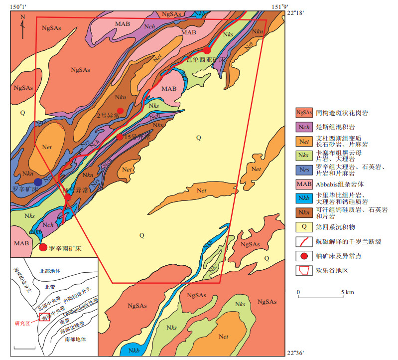
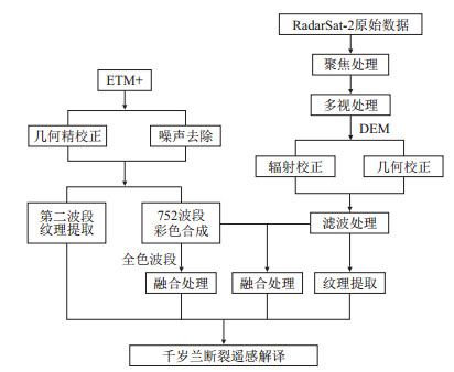
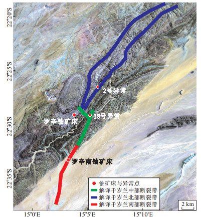
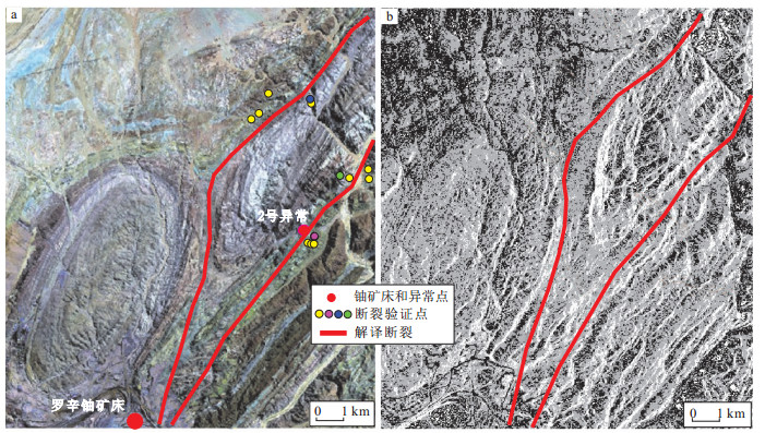
Because the images could display the physical characteristics and their surface morphology of geological structures intuitively and make up for the limitations of field investigation, remote sensing technology is favored by many geoscientists in the field of mineralization environment identification and resource evaluation. The paper took the leucogranite-type uranium metallogenic area in Gaudeanmus, Namibia as the research area, carried out the information enhancement of images such as color composition, texture information extraction, optical and radar image fusion, and constructed the marks for fault identification from stratum, leucogranite bodies, structure, geomorphology, water system, vegetation and so on, based on the multi-source remote sensing data of ETM+ and Radarsat-2.Leucogranite bodies and layers were cut or folded to form a vault.The landform appeared as a tectonic fracture, silicification, kaolinization, potassic alteration, calcitization, chloritization and were developed. Furthermore, the paper identified the partly outcropping and partly buried fault named Qiansuilan that was the largest and most important ore-controlled fault in the region, based on the fault identification marks and method. Furthermore, it was proposed innovatively that the Qiansuilan fault was not a group of faults in the area, but a fault zone consisting of three groups of faults named the northern, central and southern faults zone. Combined with the fault identification feature exposed in the field and ore-controlling analysis, the Qiansuilan fault existed truly and it controlled the occurrence of leucogranite rich in uranium and uranium mineralization in the area.