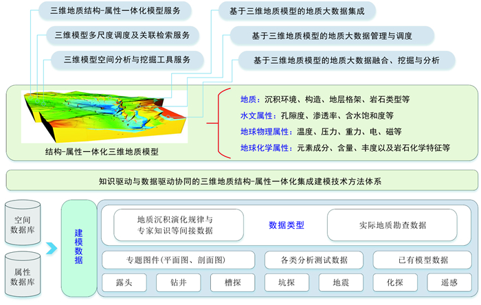
2020 Vol. 39, No. 4

Display Method:
CONTENTS
2020, 39(4)
Abstract PDF icon119 icon1583
Abstract:
Fundamental problems of integrated application of big data in geoscience
Wu Chonglong, Liu Gang, Zhou Qi, Zhang Xialin, Xu Kai
2020, 39(4): 1-11. doi: 10.19509/j.cnki.dzkq.2020.0401
Abstract:
The polymerization and utilization of geological science big data involves a series of theoretical, methodological and technical problems: multi-source, multi-class, heterogeneous and isomerism geological data collection, storage and management; data converge, integration and structuring, visualization conversion; data assimilation, fusion and depth mining, breadth-gathering and associated. Problems are also found in the pattern, method and way of effective utilization of geological big data, as well as the mode and system architecture of cloud service. The challenge is to realize the integrated storage, management, processing and application of structured, semi-structured and unstructured data, static survey data and dynamic monitoring data, as well as the contradiction and unity between big data and small data, mixed data and accuracy data, model and no model, correlation and causality.
Three-dimensional geological modeling of manganese deposits based on exploration big data and data market
Zhang Xialin, Wu Chonglong, Zhou Qi, Weng Zhengping, Yuan Liangjun, He Kunyang, Zhang Quanli, Yang Bingnan
2020, 39(4): 12-20. doi: 10.19509/j.cnki.dzkq.2020.0402
Abstract:
Taking Lijiawan-Gaodi-Datuo super-large "Datangpo" manganese deposit in northeastern Guizhou as an example, this paper discusses the idea and method of establishing a data market of manganese mine exploration data through collecting, extracting and ETL operation of exploration data based on the analysis of the characteristics and structure of large geological data. Furthermore, the paper describes the way to establish a high-precision three-dimensional geological model of super-large manganese deposits in northeastern Guizhou based on the established data market. The three-dimensional geological model of the deposit condenses a large amount of spatial data and attribute data, and is an effective carrier for large data of heterogeneous exploration and development in manganese mines. Based on the fine and holographic three-dimensional geological model of the deposit, the model not only can directly reflect the characteristics of the deposit and orebody, but also can be used as a visual analysis tool for mine management and prospecting prediction in deep and peripheral areas.
Intelligent data acquisition and visualization technology of field geology based on mobile devices
Zhang Xialin, Shi Zhilong, Wu Chonglong, Zhang Minglin, Zhou Qi, Yuan Liangjun, Hu Zhengbin, Yang Bingnan
2020, 39(4): 21-28. doi: 10.19509/j.cnki.dzkq.2020.0403
Abstract:
There are many sources, complicated types and huge quantity of field geological data, but the low digitization degree of data acquisition method and poor efficiency lead to the bottleneck of field geological data acquisition by big data. Field geological data acquisition based on mobile smartphones, tablets and other mobile devices is a trend. This paper studies the intelligent acquisition technology of field geological big data based on mobile devices. This technology adopts the mobile device with Android system, uses such methods as sensor-assisted cataloging, speech recognition-assisted cataloging, customizable dictionary-assisted editing, interface customization and associated data auxiliary cataloging, to assist the field data fast and intelligent collection work. In the field, this technology also can use the collected data on the Android to directly draw the geological map, and make the data visual on-site. Using the field drilling data, the study tested functions of data collection and geological catalog drawing. The results show that the method proposed in this paper can improve the efficiency and quality of data collection, and can directly draw geological map in the field.
Key technologies of geological big data visualization
Tian Yiping, Wu Chonglong, Weng Zhengping, Liu Gang, Zhang Zhiting, Chen Qiyu
2020, 39(4): 29-36. doi: 10.19509/j.cnki.dzkq.2020.0404
Abstract:
This paper describes in detail the research contents of visualization of geological big data. Its application classification includes expression visualization, analysis visualization, procedure visualization, design visualization and decision visualization. The paper also discusses in length several key technologies involved in the five types of visualization of geological big data: 3D visualization dynamic fine modeling technology of geological body; Parallel visualization technology of geological body attribute field data based on CUDA+GPU cluster; Visualization analysis technology for geological big data; Virtual reality and augmented reality technology based on geological big data. The status quo, technical route and implementation effect of these key technologies are discussed and demonstrated.
Extraction of hidden manganese ore information with combined mining of associated and secondary mineral of remote sensing data in northeast Guizhou
Xu Kai, Yuan Liangjun, Yang Bingnan, Kong Chunfang, Zhang Xialin, Zheng Jing, Zhou Qi, Wu Chonglong
2020, 39(4): 37-43. doi: 10.19509/j.cnki.dzkq.2020.0405
Abstract:
The northeast Guizhou manganese ore area is taken as a study area in the paper. The associated pyrite, chlorite and the secondary manganese oxide were as extraction marks of manganese ore by analyzing the characteristics of the manganese-bearing strata, the ore deposits and the ore bodies. Furthermore, the manganese mineralization information of ASTER image is extracted by using the combined data mining method based on principal component analysis, support vector machine and ant colony algorithm, and then the abnormal region of remote sensing image is delineated. Compared with the abnormal region and the proved deposits, there is a better consistency in spatial distribution. The results show that the combined mining method system for hidden manganese ore based on the remote sensing data of associated and secondary minerals proposed in this paper is feasible and practical for delineating the favorable metallogenic area of "Datangpo type" manganese ore.
Review on geoscience time series big data similarity measurement and index method
He Zhenwen, Wu Chonglong, Liu Gang, Tian Yiping, Zhang Xialin, Chen Qiyu
2020, 39(4): 44-50. doi: 10.19509/j.cnki.dzkq.2020.0406
Abstract:
Geoscience time series big data is a kind of multi-sensor, multi-target, multi-resolution, multi-type, and multi-source heterogeneous time data, and is an important data source for machine learning and data mining in the field of geosciences. Geosciences time series data has two categories: the time point data set, and the time interval data set. The main data representation methods, similarity measurements and data indexing methods of existing time series data focus on time-points-based time series data. The core idea of the representation method for time series data is dimensionality reduction. It is the basis of similarity measurement and indexing method, including domain-transformation-based, model-based and pieces-based representation methods. The key of similarity measurement is the similarity distance including lock-step measurement and elasticity measurement. It provides a basic guideline for the aggregation and division of index items in the index of time series data. The efficient similarity measurement and distributed indexing method of multi-source heterogeneous time series big data will be an important further direction in the field of geosciences big data.
Current situation and prospect of structure-attribute integrated 3D geological modeling technology for geological big data
Chen Qiyu, Liu Gang, He Zhenwen, Zhang Xialin, Wu Chonglong
2020, 39(4): 51-58. doi: 10.19509/j.cnki.dzkq.2020.0407
Abstract:
The goal of three-dimensional (3D) geological modeling not only realizes the visual expression of geological objects, but also achieves the aggregation, management, mining, analysis and sharing of geological big data. However, traditional methods and techniques are difficult to achieve structural-attribute integrated 3D geological modeling and coupled expression that considers geological semantics. Although multiple-point geostatistical methods facilitate the fusion modeling of multiple-source data, geological prior knowledge, and structure-attribute, they are still limited by the insufficient expression ability of data models, the difficulty in obtaining the 3D training images, and the non-stationary phenomenon. For geological big data, this papaper discusses throughly the spatial data model, the multiple-point geostatistics-based structure-attribute integrated modeling method, and the framework of integration and management for geological big data with a unified 3D geological model. We believe that ① developing new unified spatial data models for geological structure-attribute coupling expression, ② exploring knowledge-driven and data-driven collaborative 3D geological structure-attribute integrated modeling technologies, ③ constructing a visual environment and operation platform for the aggregation, integration, management, mining and analysis of geological big data, will be the research hotspots and the frontier directions in the field of 3D geological modeling in the future.
Discussion on dynamic orebody modeling with geological science big data
Li Zhanglin, Wu Chonglong, Zhang Xialin, Weng Zhengping, Liu Gang, Zhang Zhiting, Zhang Junqiang
2020, 39(4): 59-68. doi: 10.19509/j.cnki.dzkq.2020.0408
Abstract:
As a key technology of geological information systems and an important method for geological information science, three dimensional geoscience modelling (3DGM) faces many opportunities and challenges in the age of big data. Many experts in this field are discussing ways to improve 3DGM in this context. From the point view of 3D implicit modeling, an up-to-date 3DGM method, this paper discusses several issues on this point such as the integration of a geological big data system and 3DGM, and the possible ways to enhance the quality and efficiency of 3DGM based on big data technologies. The paper proposes an initial integration framework of big data based 3DGM consisting of data collection, construction of subject-oriented big data system, geological feature mining and dynamic orebody modeling. This research also suggests that the approaches of geological artificial intelligence, machine learning, data mining, and predication should be designed and applied with full consideration of essential characteristics of the geological objects under study, which is crucial to improve the modeling result. The feasibility of the proposed method is illustrated by a case study on orebody modeling.
Fault modeling based on the semantic constraint of geological big data
Wang Tong, Tian Yiping, Luo Yingying, Zhang Rui
2020, 39(4): 69-75. doi: 10.19509/j.cnki.dzkq.2020.0409
Abstract:
Faults, as an important geological structure, are ubiquitous in nature.In 3d modeling of geological body, the difficulty of fault processing lies in obtaining data.Nowadays, under the condition of geological big data, different geological semantic constraints can be used to predict the occurrence of faults.However, as fault structures are often very complex, it is necessary to clarify the morphological classification of faults and their data models in order to use geological big data for constraint modeling of fault structures. This paper studies classification of faults and extracts factors that affect occurrence of faults. These factors are taken as part of fault data model and as mining target in the big data mining of geology. They can constitute table of geological semantic information of faults to provide data support for subsequent fault modeling.On this basis, a new fault modeling idea is proposed, that is, fault is regarded as a whole, and section fault geological semantic information table is classified by Aprirori algorithm to find standard model of each fault. Then, the fault model is constrained by geometric form by using the fault semantic information table to form a fault model with the specific geological semantics. Finally, through smooth transition of the fault traction structure, the fault is embedded in established stratigraphic framework model to complete three-dimensional modeling of the fault.
Effect of pH value and Fe(Ⅲ) on the oxidative dissolution of stibnite
Jiang Nan, Li Xiaoqian, Zhou Aiguo, Huang Yuliu, Pan Guofang
2020, 39(4): 76-84. doi: 10.19509/j.cnki.dzkq.2020.0410
Abstract:
The stibnite oxidative dissolution under the influence of mining activities is an important process affecting the mobilization of antimony in rock-soil-water environmental medium and its environmental effects. At present, the researches mainly focus on the kinetic characteristic of stibnite dissolution, and the understandings about important issues such as the pathway of stibnite oxidative dissolution, the influence of environmental factors, and the process of antimony release are not clear. In order to study the mechanism of antimony release into groundwater in mining area where the main lithology is carbonatite, important environmental factors pH value and Fe(Ⅲ) were selected. The batch experiment method under single-factor control condition was used to finely describe the oxidation dissolution rate of Sb2S3 and the composition characteristics of Sb and S oxidation products under dark conditions. The results show that Sb2S3 oxidative dissolution was a proton-producing process, and the Sb and S release rates, release pathways and reaction products characteristics were significantly affected by pH value and Fe (Ⅲ). Sb2S3 oxidative dissolution rate changed from rapid to slow and finally reached equilibrium. The magnitude of initial reaction rate was 10-8 mol/(m2·s), and the magnitude of equilibrium reaction rate was 10-10 mol/(m2·s). The release and oxidation rates of antimony increased with the increasing of pH value, and the strong alkali condition was the most favorable condition for the release and oxidation of Sb. Under strong acid condition, the escape of H2S and SO2 gas coupled with the precipitation of elemental sulfur promoted the dissolution of Sb2S3. Sb(Ⅲ) and S(0) were the dominate reaction products. Under neutral condition, dissolved HS- was gradually oxidized to SO42- and a small amount of S2O32-, meanwhile the concentration of Sb(Ⅲ) and Sb(Ⅴ) were similar. Under strong alkali conditions, the formation of SbS33- and Sx- significantly facilitated the Sb2S3 oxidative dissolution rate. Sb(Ⅴ) and S2O32- were the primary species. While Fe(Ⅲ) worked as the lone oxidant, Sb(Ⅴ) and S(0) were the main reaction products. However, the apparent rate of antimony release was not significantly increased, probably due to the precipitation of SbOCl and S(0). Studies have shown that O2 can cooperate with Fe (Ⅲ) to oxidize Sb2S3, meanwhile Fe(Ⅲ) plays the major role in the reaction. This study characterizes the product composition characteristics of Sb2S3 oxidative dissolution under different pH values and oxidants, and proposes the Sb2S3 oxidative dissolution pathways are affected by different environmental factors. Carbonatite formation which can be a natural buffer is conducive to release and oxidation of antimony, and the environmental problem induced by antimony in karst groundwater will be more serious.
Landslide hazard analysis of Liyuan Town based on effective rainfall threshold
Zhao Haiyan, Yin Kunlong, Chen Lixia, Guo Zizheng, Yang Yonggang, Tan Mengjiao
2020, 39(4): 85-93. doi: 10.19509/j.cnki.dzkq.2020.0431
Abstract:
This paper takes Liyuan Town of Hunan Province as an example, and used the weight of evidence model and the grey relational degree model to calculate separately the weights of the five factors of slope, formation lithology, shape of slope, land use type and human engineering activity in secondary states and in first states. After defining the landslide susceptibility index of the whole region by combining two models, the susceptibility zoning based on the slope unit is completed. According to the geotechnical geological type of the rock and soil in the study area (clastic rocks, carbonate nip clastic rocks, carbonate rocks and loose rock soils), the effective rainfall threshold curves (I-D curve) under different landslides occurrence probability are determined by grouping. The time probability of landslides in different rock and soil types under 3-day duration and effective intensity of 22.4mm/d is studied. Finally, the landslide hazard zoning map of Liyuan Town based on effective rainfall threshold is obtained through. combining time probability and susceptibility results. The results show that the high-susceptible areas and extremely high-susceptible areas account for 25% of the total study area and distributed mainly along the river. The extremely high-hazard areas account for 14% of the total study area and are mainly distributed in the north of the river.
Characteristics of glacial lakes in the central part of the southern Altai Mountains from 1972 to 2017 and their responses to climate changes
Abudula·Abudukadier, Dong Yusen, Wu Yukuan, Cui Jingyue, Yue Wenli, Zhang Bangzheng
2020, 39(4): 94-102. doi: 10.19509/j.cnki.dzkq.2020.0412
Abstract:
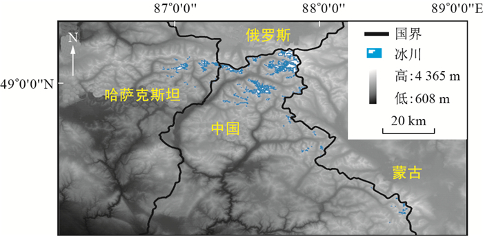
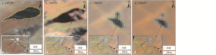
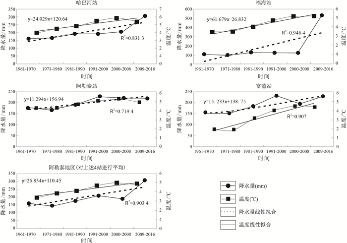
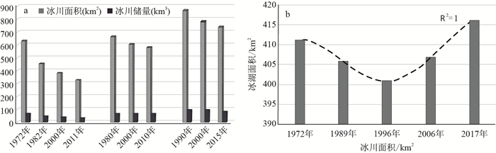
This paper used the Landsat MSS/TM/ETM/OLI remote sensing image data, digital elevation model (DEM) data and meteorological data from five different periods in 1972, 1989, 1996, 2006 and 2017 are used as data sources, and obtained the glacial lake information in the central part of South Altai Mountains by the method of automatic computer extraction and manual visual interpretation. This paper counted the area of glacial lakes in this area by GIS spatial analysis method, and analyzes the glacial lakes in different scales in the study area. The paper also analysed the slope, temporal and spatial variation characteristics at different elevations. The results show that: ① In the past 45 years, the area of glacial lakes in the central part of South Altai Mountains showed the trend of "decreasing at first and then increasing". From 1972 to 1996, the area of glacial lakes in the study area decreased from 411.14 km2 to 400.83 km2, a total of 10.31 km2 was reduced. The reduction rate of ice lake was 0.43 km2/a. From 1996 to 2017, the area increased by 15.42 km2; to 0.514 km2/a. ②The distribution of ice lakes in the study area is mainly concentrated in the area where the elevation is lower than 2 200 m and the slope is smaller than 25°.The area of glacial lakes in different altitude range and different slope range shows the trend of "decreasing first and then increasing". ②Combining with the analysis of temperature and precipitation data, we find that the change of glacial lake area in the central part of South Altai Mountains has obvious response to regional climate change. Temperature, precipitation and glacier melt water are the main factors affecting the change of glacial lake area. There is an equilibrium relationship among them, that is, the melting rate of glacier increases with the increase of temperature, which has an impact on the balance of revenue and expenditure of glacial lake. When the recharge amount of glacial lake (that is, the sum of glacier melt water and precipitation) is larger than the evaporation caused by rising temperature, the area of glacial lake will increase, and vice versa. The interdecadal precipitation of the whole Altay region decreased by 19.28mm from 1970 to 1980. The temperature increased by 0.25℃, which also led to the evaporation of glacial lake in the study area from 1972 to 1989, larger than that of recharge water, so the area of glacial lakes shrank during this period. From 1989 to 1996, the precipitation in this area increased by 19.67%, and the temperature increased by 0.62℃, but the increased precipitation cannot make up for the evaporation amount of glacial lake caused by the increase of temperature. Therefore, the area of glacial lakes in the study area from 1989 to 1996 is still in a state of retreat. From 1996 to 2017, the area of glacial lakes showed a growing trend due to the increase of temperature and precipitation.
Model test on the displacement field characteristics of the landslide stabilizing piles
Wang Xuan, Hu Xinli, Zhou Chang, Li Lanxing
2020, 39(4): 103-108. doi: 10.19509/j.cnki.dzkq.2020.0413
Abstract:
The evolution mechanism of landslide anti-slide pile system is an important theoretical basis for landslide hazard prevention. Pile-soil interaction is the key of landslide anti-slide pile system, and displacement field is one of the important symbols of interaction. Therefore, the study of displacement field of landslide anti-slide pile system is of great significance in the field of engineering. Based on the engineering geological characteristics of accumulation landslide in Three Gorges Reservoir area, a large-scale physical test model is established. The thrust of the rear edge of the landslide is simulated by applying load step by step. The displacement data of the landslide slope surface and the top of the piles are obtained by using high-speed video camera and particle image velocity technology, and the variation characteristics of the displacement field of the system are quantitatively analyzed. The test results show that the displacement field presents a good regularity in the evolution process, which plays a certain role in promoting the research on the mechanism of pile-soil interaction.
Effect of shield tunneling construction on bearing capacity of foundation of existing buildings and stability analysis of reinforced soil
Wang Zhongkai, Xu Guangli
2020, 39(4): 109-116. doi: 10.19509/j.cnki.dzkq.2020.0414
Abstract:
The current foundation reinforcement of existing buildings (structures) in shield tunneling construction depends on experience and lacks perfect theory as support. To better this situation, this paper studies the influence mechanism of bearing capacity of existing buildings (structures) in shield tunneling and after leaving and the stability of soil after reinforcement. In order to understand the shear state of cement-soil reinforcement, the triaxial test of cement-soil is carried out. The results show that before the deviating stress reaches the yield point, the relationship of (σ1-σ3)-ε1 is approximately linear and the strain is very small, and the shear strength of the reinforcement is far from that of the unreinforced soil. In stability analysis, the displacement of the reinforcement body and the share of shear force of the unreinforced soil outside the reinforcement body are not taken into account. In shield tunneling, the squeezing of the surrounding soil to produce shear stress diffuses to the pile side to form additional positive friction resistance, and thus increases the bearing capacity of the pile. After the shield tunneling leaves, the soil unloads, the negative friction resistance occurs at the pile side, and the bearing capacity of the pile decreases. In shield tunneling construction, the upper part of reinforcement body is subjected to passive or active earth pressure, the outer part and the lower part are subjected to static earth pressure, the difference of earth pressure produces shear stress, the potential sliding interface produces tension and compression stress, and the formula of safety factor of composite sliding surface of soil after reinforcement is derived. The strength of reinforcement body and the stability of soil after reinforcement are checked through engineering examples.
Fine characterization of the reservoir space in deep ultra-low porosity and ultra-low permeability glutenite in Bozhong Sag
Zhang Tongyao, Hao Peng
2020, 39(4): 117-124. doi: 10.19509/j.cnki.dzkq.2020.0415
Abstract:
With the application of automatic mineral quantitative identification system (QEMSCAN), modular automated processing system (MPAS), multi-scale micro CT, thin section identification, constant-rate mercury injection and other experimental techniques, the reservoir space in deep ultra-low porosity and ultra-low permeability glutenite of Kongdian Formation in the Bozhong Sag were characterized in two and three dimensions, and the influencing factors of the permeability of glutenite reservoir were studied in detail. The experimental results show that the glutenite in the study area has millimeter, micron and nanometer pores. For the samples with relatively large porosity, there are relatively more interparticle pores and interparticle dissolution pores in the reservoir. On the basis of the three-dimensional pore-throat network model, the most part of the pore radius ranges from 0.3 to 10 μm and the roar channel radius mainly ranges from 0.5 to 8.0 μm. The pore-throat distribution is mainly three forms: banded, contiguous and isolated. The pore throats of reservoirs with good reservoir properties are mostly continuous in three-dimensional space, and the reservoirs with relatively poor permeability contain more isolated large pores. The fluid mobility of porous reservoir is closely related to throat radius, pore-throat shape, coordination number and other parameters. Fractures improve the physical properties of glutenite obviously, and also provide a channel for the acid solution to the reservoir and promotes the formation of dissolution pores. Comprehensive study showed that the fluid flow of the glutenite in the Bozhong Sag is controlled by the fracture and the pore-throat connectivity. The cementation of clay and carbonate minerals in the reservoir has an important influence on the pore structure and permeability.
Quantitative analysis of fault vertical sealing ability and its application in A Oilfield of Bohai Bay Basin
Li Hao, Wu Jintao, Huang Jianting, Wang Yue, Li Zhenpeng
2020, 39(4): 125-131. doi: 10.19509/j.cnki.dzkq.2020.0416
Abstract:
In the reservoir, the degree of fault vertical sealing has an important effect on the physical properties of crude oil. Based on the study of mechanism of sealing and its influencing factors, through comparative analysis of the normal pressure on the vertical section (δF) and the compressive strength of material in the facture zone (δC), a method for judging fault vertical sealing ability by using fault tightness index(IFT) is established, which is defined as the ratio of δF to δC and is applied to study on the crude property difference of A Oilfield in Bohai Bay Basin. The result shows that IFT is not the same for different faults and higher IFT values would indicate improved fault vertical sealing property. In case that fault is broken to the base of the buried hill but the seabed is not communicated, heat from the deep layer migrates to the shallow layer, and forms a local high temperature environment in A Oilfield, inhibiting the degree of biodegradation and gives a good crude oil property. Due to the diversity of normal stress on fault surface and the filling substance of fault zone in different locations of the same fault, IFT is constantly changing along fault strike. Owing to IFT values of the main faults in the fault block area with a SW-NE decreasing trend, biodegradation of different levels results in the gradual rise of formation oil viscosity from southwest to northwest. The judging result accords with the crude property difference distribution of A Oilfield, which indicates that the method is feasible to judge fault vertical sealing property.
Sedimentary facies characteristics and accumulation systems of Albian-Turonian at the outer shelf-slope area of MSGB Basin
Chen Liang, Zhao Hongyan, Han Wenming, Kong Lingwu, Zhao Jiaqi, Feng Xin, Yu Yingmei
2020, 39(4): 132-140. doi: 10.19509/j.cnki.dzkq.2020.0417
Abstract:
In recent years, several large oil and gas discoveries have made the MSGB Basin a hot spot for international oil and gas explorations. Based on seismic data and drilling and logging data, this paper studies sedimentary facies and sedimentary models, and analyses reservoir physical properties, source rock evaluation and hydrocarbon accumulation models. The results show first that the multi-stage forced regressive delta is widely developed at the southern outer shelf of the basin. Controlled by the base surface cycle, the topset of delta is eroded, and the sand body is transported to the front of the delta to form forced regressive sands. The sand body is widely distributed near the edge of the shelf. Slope type controls the distribution patterns of deep-water fans, and southern faulted slope controls the distribution of the deep-water fans. Fans mainly develop in continental slope foot, close to the shelf edge. Gravity flow is carried far on the northern gentle slope, deep-water fans away from the shelf edge. We established two types of sedimentary models. Then, the results indicate the forced regressive deltas at the outer shelf and northern deep-water fans at gentle slope have good reservoir properties and high test productivity. Southern deep-water fan has poor reservoir properties due to cementation and slump debris. Also, oil-source correlation shows that oil and gas mainly come from Lower Cretaceous Aptian to Albian and Upper Cretaceous Cenomanian to Turonian marine source rocks. Aptian to Albian source rock with Ⅱ2 kerogen type tends to generate gas and Cenomanian to Turonian source rocks with I kerogen type tends to generate oil. Lastly, there are three favorable hydrocarbon accumulation systems in the study area, namely Albian accumulation system at shelf margin, Albian to Turonian hydrocarbon accumulation system at slope foot and Cenomanian hydrocarbon accumulation system at distal slope. Hydrocarbon accumulation system at shelf margin and distal slope have greater exploration potential, a favorable direction for the next exploration.
Organic geochemistry of the Late Permian coal from the Songhe Mine, Guizhou
Wu Shihao, Bo Penghui, Xu Fei, Wang Yan, Lu Qingfeng, Qin Shenjun
2020, 39(4): 141-149. doi: 10.19509/j.cnki.dzkq.2020.0418
Abstract:
The Late Permian coal samples selected from Songhe Mine, Guizhou Province, were investigated by organic geochemical methods. Optical microscopy was used to observe coal components and determine vitrinite reflectance. Saturated hydrocarbons and aromatic hydrocarbons in coals were analyzed by gas chromatography (GC) and gas chromatography-mass spectrometry (GC-MS), and the related organic geochemical parameters were calculated. The results show that the content of vitrinite in Songhe coal samples is the highest, with the average vitrinite reflectance (Ro) 1.21%. The carbon number of n-alkanes ranges from C12 to C29, and the main peak carbon is C14 or C15. The value of ∑C21-/∑C22+ is higher, and the value of odd-even predominance (OEP) is close to 1, and the pristane/phytane (Pr/Ph) ratio is from 1.40 to 2.65. There are many kinds of aromatic hydrocarbons detected. The contents of naphthalene and phenanthrene compounds derived from resins are predominant, and the isomers of aromatic hydrocarbons with higher thermodynamic stability has an advantage position. The data analyses indicate that the coal-forming parent material is mainly from terrestrial higher plants, accompanied by the contribution of marine phytoplankton. The coal sample has higher maturity. The relative higher contents of fluorenes and benzonaphthothiophenes indicate that coal seams were mainly formed in reducing environment.
Late Triassic post-collision extension at Elashan magmatic belt, East Kunlun Orogenic Belt: Insights from Suolagou highly fractionated I-type granite
Zhou Hongzhi, Wei Junhao, Shi Wenjie, Zhang Songtao, Chen Jiajie, Zhang Xinming, Shen Zhiyuan, Wang Yilong, Zeng Runling
2020, 39(4): 150-164. doi: 10.19509/j.cnki.dzkq.2020.0430
Abstract:
Studying the Elashan magmatic belt located easternmost of the East Kunlun Orogenic Belt (EKOB), we present zircon U-Pb age and Lu-Hf isotopes and whole-rock chemistry of syenogranite, from Suolagou area, in order to discuss its rock type and tectonic setting. The zircon weighted mean ages of the syenogranite is (223±1) Ma, indicating it was formed in the Late Triassic. The syenogranite is characterized by high silic, enrichment of alkaline, but depletion in calcium, magnesium, titanium and phosphorus. The A/CNK values range from 1.01 to 1.05, showing a peralkaline affinity, with strong negative Eu anomalies (Eu/Eu*=0.09-0.25). Zircon saturation temperatures are 733 to 768℃ and the syenogranite. The rock is obviously enriched in large ion lithophile elements (LILE Rb, Th, U, K, etc.) and light rare earth elements (LREE), and depleted in Ba, Sr and Nb, P, Zr, Ti and other high field strength elements (HFSE), showing characteristics of highly fractionated I-type granites. The initial zircon Hf isotope value (176Hf/177Hf)i ranges from 0.282 487 to 0.282 611, εHf(t) ranges from -3.54 to -0.56, and two-stage mode age T2DM(Hf) is 1.16 to 1.33 Ga. The rock is formed by crystallization after partial melting of the juvenile lower crust, and the juvenile lower crust is formed by the mantle-derived magma underlying the ancient crust during the northward subduction stage of the Paleo-Tethys Ocean(242-238 Ma). Combining with the Late Paleozoic to Mesozoic tectonic evolution of the East Kunlun area, we suggest that the syenogranite is formed in the extensional tectonic setting, related to the post-collision extension of the Bayan Kala terrane and the East Kunlun (close of Paleo-Tethys ocean).
"Sweet spot" identification and evaluation of tight sandstone reservoir
Zhou Lin, Liu Haotian, Zhou Kun, Hao Jingyu, Wang Xin
2020, 39(4): 165-173. doi: 10.19509/j.cnki.dzkq.2020.0420
Abstract:
Located in the north of the Sichuan Basin, the 4th Member of Xujiahe Formation features braided-river, delta-front deposits, and extremely developed sand body. Due to the large burial depth, strong reservoir heterogeneity, and complex pore structure, the exploration and development of low permeability tight sandstone gas reservoir are greatly constrained by the identification and comprehensive evaluation of "sweet spots". Based on the extensive observation and identification of thin-section and in reference to logging data, this paper analyzes the key geological factors controlling the ultra-low permeability tight sandstone gas reservoir, puts forward a qualitative "sweet spots" identification model based on factor analysis for tight sandstone gas reservoir, and conducts comprehensive evaluation of the 4th Member of Xujiahe Formation in the target block in northern Sichuan Basin. The results show, ① "Sweet spots" region with good physical properties exists in some areas of tight sandstone gas reservoir; ② The three parameter factors extracted by the factor analysis can qualitatively explain the characteristics of tight sandstone gas reservoir and accurately identify the "sweet spots" section; ③ The quantitative evaluation results of the factor analysis are in good agreement with the actual exploration and development effect of the 4th Member of Xujiahe Formation in northern Sichuan Basin, and are much more accurate than those of the common evaluation methods; ④Reservoir of the 4th Member of Xujiahe Formation in North Sichuan can be divided into three types, and the target block has mostly developed type Ⅱ reservoir, and the key area of gas reservoir development rests in the NE trending gas-rich region in the southeastern part of the block.
Resistance reduction by grouting to large diameter and long distance steel pipe jacking:A case study of pipe jacking project in the upstream water source area of Huangpu River
Feng Rui, Zhang Peng, Su Shuyao, Ma Baosong
2020, 39(4): 174-180. doi: 10.19509/j.cnki.dzkq.2020.0421
Abstract:
C3 section in the connecting pipe jacking project in the upstream water source area of Huangpu River is constructed by DN4000 steel pipe jacking with the length of 969.94m in a single jacking. As the reduction of resistance is the key aspect of the project, this paper studies the preparation and the use of slurry in order to reduce the resistance to decrease jacking force. Besides, based on the change of jacking force under the geological conditions of JB06-JB05 and JB07-JB06, the paper analyses the variation rule of resistance. The results show: ①The reduction effect is obvious with proper arrangement of grouting holes, the preparation and use of slurry. ②Jacking force is approximately linear with jacking distance but the character of geological condition may lead to sudden change of jacking force. ③The slurry which has been injected for some time performs better than freshly injected slurry. ④Friction can be effectively reduced by increasing the grouting volume properly. ⑤Polymer bentonite mud is more expensive but the grouting volume of it is less. Considering various kinds of factors, polymer bentonite mud is more favorable than bentonite mud.
Application of all-phase model estimation method for suppressing magnetic resonance sounding harmonic noise
Chen Liang, Li Fan, Lu Kai, Chen Jiahong, Zhang Jiagang, Li Zhenyu
2020, 39(4): 181-188. doi: 10.19509/j.cnki.dzkq.2020.0422
Abstract:
Magnetic resonance sounding is currently the only direct geophysical method of groundwater exploration. The instrument of magnetic resonance sounding has high sensitivity for detecting and receiving performance, and can receive nanovolt (1nV= V) NMR signals, but is susceptible to environmental electromagnetic noise. This restrains the accuracy of the magnetic resonance sounding interpretation results which cannot be reversed to the actual underground aquifer structure. This study proposes an all-phase model estimation method to suppress the power frequency harmonic noise with the largest specific gravity in electromagnetic noise. High-precision harmonic modeling is the key to modeling cancellation. This method uses two-stage noisy NMR signals with time-shift relationship to perform all-phase FFT processing. The phase value of the main line is taken as the phase estimation. The phase difference of the main line can be used to obtain high-precision frequency estimation and amplitude estimation. The all-phase FFT has good frequency leakage suppression characteristics compared with the conventional FFT. Through simulation experiments, we find that the all-phase model estimation method can obtain the power frequency harmonic parameters more accurately than the traditional model denoising method, and the precision is more than doubled. Through the test of the measured data, we find that the all-phase model estimation method can better cope with the complex and variable conditions of the actual noise, effectively suppress the interference of the power frequency harmonics, and improve the accuracy of the MRS method inversion interpretation.
Recognition of the Martian minerals based on the deep belief networks method: Application in the CRISM images
Zhang Xubing, Wang Xianmin, Wang Kai, Yue Qiaobing, Zhang Liang
2020, 39(4): 189-200. doi: 10.19509/j.cnki.dzkq.2020.0423
Abstract:
In order to decrease recognition inaccuracies of the different minerals with similar single absorption peak by means of the spectral characteristic parameter methods which are difficult to estimate the spectrum of the whole wavelength range, this paper applied the deep belief networks (DBN) method to detect the Martian minerals from the hyperspectral images of the compact reconnaissance imaging spectrometer for Mars (CRISM). According to the method, firstly, the unsupervised layer-by-layer greedy algorithm is adopted to train each restricted Boltzmann machine (RBM) for the sake of learning parameters and extracting the spectral features of the minerals with a single bottom-up pass. Then, it takes advantage of the back propagation (BP) algorithm to tune the parameters learned in the train step and automatically identify the Martian minerals with coupling a suitable classifier. In this paper, the ratios of the minerals spectral and the dust spectral are utilized to identify the mineral samples for sake of decreasing the dust effect. Finally the influences of the sample size, the number of the hidden layer nodes, and the network depth are investigated to established the optimal deep belief networks for the recognition of the Martian minerals. As illustrated by the case of the Mg/Fe smectites and the chlorides from the CRISM images, the experimental results indicate that the recognition accuracy of the DBN method is more than 85%. In conclusion, the DBN method has a better performance in detecting some pixels of the minerals that the spectral parameter algorithm cannot detect in the CRISM images, and the deep learning method could be utilized in the recognition of the Martian minerals automatically.