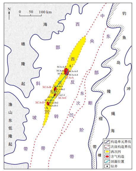
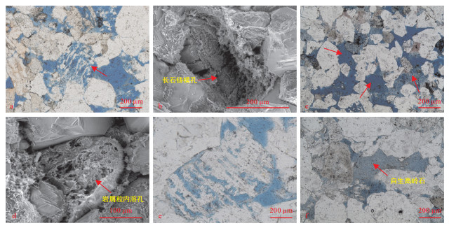
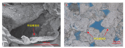
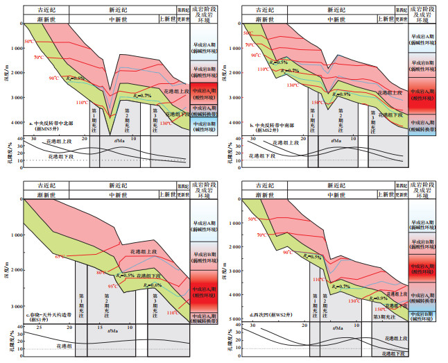
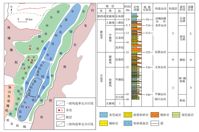
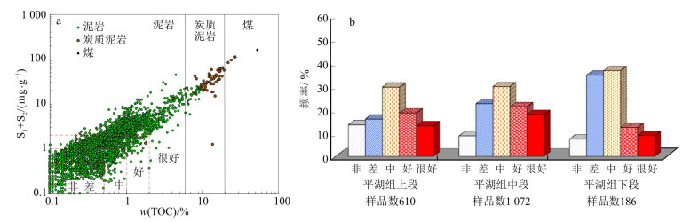
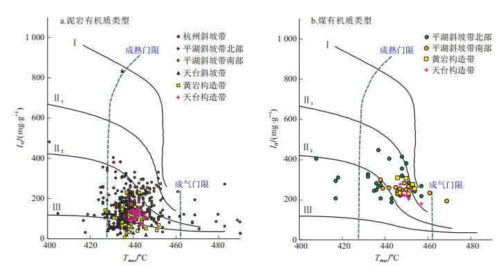
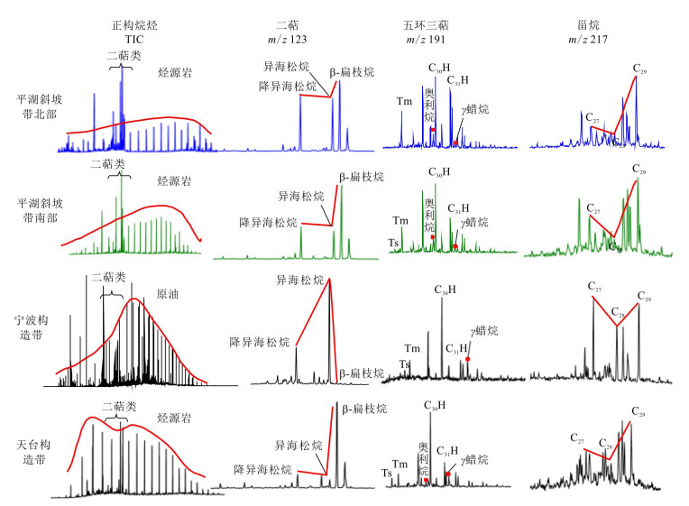
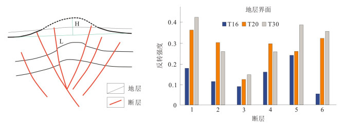
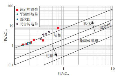
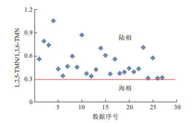
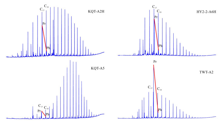
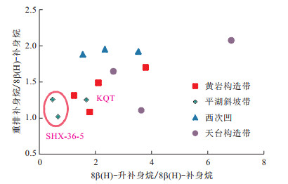
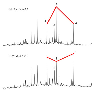
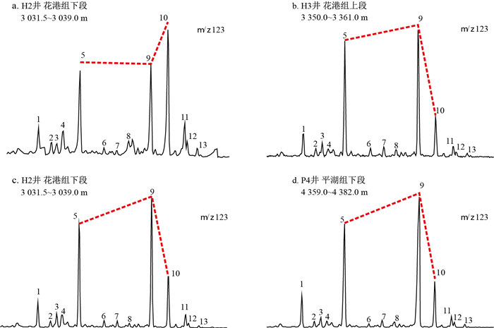
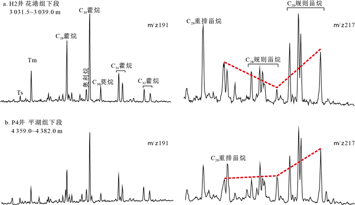
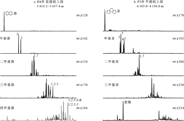
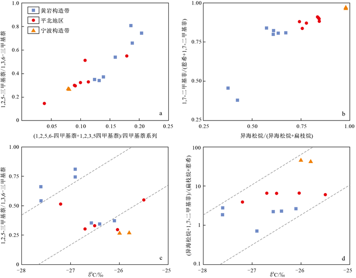
2020 Vol. 39, No. 3

Display Method:
CONTENTS
2020, 39(3)
Abstract:
Grading evaluation of natural gas resources in the western sub-sag of Xihu Depression, East China Sea Basin
Ye Jiaren, Liu Jinshui, Xu Chenjie, Cao Qiang, Sheng Yiyong, Yu Hanwen
2020, 39(3): 1-9. doi: 10.19509/j.cnki.dzkq.2020.0301
Abstract:
The discovery of abundant natural gas resources in Xihu Depression of East China Sea Shelf Basin revealed the characteristics of the coexistence of conventional, low-permeability and tight gas resources. However, the previous resource evaluation only predicted the total resources and did not distinguish among conventional, low-permeability and tight gas resources, thus failing to meet the needs of oil and gas exploration and development practices. This paper takes the western sub-sag as the study area, which is a secondary tectonic unit with relatively high oil and gas exploration and discovery in Xihu Depression. On the basis of reasonable selection of various parameters, the "volumetric method" is used to quantitatively evaluate the conventional, low-permeability and tight gas resources of the gas reservoirs discovered in the western sub-sag, and discusses the rules and the main controlling factors of the distribution and grading of natural gas resources. The research shows that the western sub-sag is rich in natural gas resources and the rules of "the tight gas content is the highest and contains a small amount of low-permeability" and "low-permeability gas is distributed in the middle and shallow layers when tight gas is distributed in the middle and deep layers". The distribution and grading of resources is controlled by a combination of factors, where the reservoir is the foundation and the source of hydrocarbons is the key. The research results will help to explore and establish the method and technology applicable to the grading evaluation of natural gas resources in Xihu Depression. It will provide scientific basis for natural gas exploration and development deployment and decision-making in the study area.
Grading evaluation of deep reservoir in Xihu Depression, East China Sea Basin
Du Xuebin, Lu Yongchao, Cao Qiang, Ye Jiaren, Jia Jixin, Zhao Ke, Duan Dan
2020, 39(3): 10-19. doi: 10.19509/j.cnki.dzkq.2020.0302
Abstract:
Xihu Depression is a sedimentary basin with the most oil and gas potential and exploration difficulty in the East China Sea Basin. The existing reservoir evaluation standard cannot fully take into account the characteristics of reservoir diversity, so the reservoir evaluation relies on the conventional standard, and the systematic reservoir classification and grading evaluation are constrained. This paper, on the basis of discussion reservoir control factors, takes the "Microfacies-Diagenesis-Temperature" as the main evaluation parameters of reservoir classification and evaluates the main reservoirs on this basis. The results show that the Huagang Formation is mainly composed of low-permeability and super-low permeability reservoirs, accounting for more than 35% of the total reservoir, and thus is the main exploration type in the future. The Pinghu Formation is mainly composed of conventional and low-permeability reservoirs. The research results establish a foundation for the later stage of resource quantity grading evaluation and, also to provide some help for same type reservoir in others basin.
Relationship between sandstone reservoirs densification and hydrocarbon charging in the Paleogene Huagang Formation of Xihu Depression, East China Sea Basin
Xu Guosheng, Cui Hengyuan, Liu Yong, Wang Yiran, Huang Siqin, Zhang Wu, Li Pengwu, Zhou Ping
2020, 39(3): 20-29. doi: 10.19509/j.cnki.dzkq.2020.0303
Abstract:
The tight sandstone gas resources in Xihu Depression of the East China Sea Basin are abundant. In recent years, the Paleogene Huagang Formation is a hot spot for exploration. However, the unclear densification of the reservoir and the matching relationship with the oil and gas charge restrict the effective exploration and economic development of the tight sandstone gas of the Huagang Formation. This study reveals the reservoir densification process and its relationship with hydrocarbon charging based on the analysis of sandstone reservoir characteristics, the classification and evolution of diagenesis type and evolution sequence.The study shows that the reservoir sandstone mainly undergoes three diagenesis processes: compaction, cementation and dissolution. Compaction is the root cause of sandstone pore loss and densification in the Huagang Formation reservoir during burial diagenesis. The formation experienced a total of three stages and five periods of diagenetic evolution, including the syngenetic stage, the early diagenetic stage (A, B period) and the middle diagenetic stage (A, B period). At the A2 period of the middle diagenetic stage, the diagenetic environment began to change from acidic to alkaline, accompanied by cementation of late carbonate and siliceous. When the strength of mechanical compaction continued to increase, the reservoir gradually became denser. Combined with the coupling relationship between oil and gas accumulation period (7-0 Ma), the Huagang Formation reservoirs in the study area are divided into three types: accumulated reservoir, synchronous dense reservoir, accumulated dense reservoir. The study combs the reservoir characteristics, diagenetic evolution sequence, reservoir densification and coupling relationship with hydrocarbon charging in the Huagang Formation of Xihu Depression, providing theoretical support for the exploration of tight sandstone gas in the next study area.
Coal source rock conditions and hydrocarbon generation model of Pinghu Formation in Xihu Depression, East China Sea Basin
Jiang Yiming, Diao Hui, Zeng Wenqian
2020, 39(3): 30-39. doi: 10.19509/j.cnki.dzkq.2020.0304
Abstract:
Xihu Depression is the most important coal-forming oil and gas depression in the offshore of China. In recent years, oil and gas exploration has confirmed that the Pinghu Formation coal-series source rocks provide abundant oil and gas resources for Xihu Depression. Different from the Mesozoic coal-forming oil and gas basins in the Terrestrial, the offshore Cenozoic transitional phase of the Cenozoic sea-continental coal source rocks is unique in terms of parent material source, hydrocarbon generation conditions and evolution characteristics. Studies have shown that the source rocks of Pinghu Formation coal-bearing source are rich in tricyclic diiso-isoaspam, beta-flatane and pentacyclic triterpenoids, indicating conifers, ferns and angiosperms. Coal source rock and carbonaceous mudstones are rich in resin, high IH, Ⅱ1-Ⅱ2 type kerogen, and wide-spread distribution characteristics; coal source rocks are rich in tricyclic diterpene iso-seapine, tetracyclic diterpenoid β-phytoplantans and pentacyclic triterpenoids orienes, indicating the source of multi-vegetative parent material of gymnosperms, ferns, and angiosperms; differences in organic matter composition, "internal heat and external cold" geothermal differences in sediment deposition velocity caused significant differences in the evolution of coal and mudstones in different tectonic zones. This difference determines that the coal-derived oil and gas resources have a distribution pattern of "simultaneous oil and gas and east-west oil", and the hydrocarbon-forming evolution of source rocks shows a pattern of "favorable oil production in the early stage and continued gas generation in the late stage".
Major controlling factors and enrichment rules of highly efficient gas reservoiring in the north-central part of the central inversion belt, Xihu Depression
Gao Weizhong
2020, 39(3): 40-48. doi: 10.19509/j.cnki.dzkq.2020.0305
Abstract:
The main controlling factors of reservoir formation and dynamic matching relationship of large gas fields in the north-central part of the central inversion belt, Xihu Depression are still unknown. Based on the systematic analysis of the key reservoir forming factors such as source rock, reservoir, transportation system and reservoir forming period, this paper establishes the dynamic reservoir forming process of "source-reservoir-Circle-Transportation" to analyze the main reservoir forming factors of the large gas field in the north of China. The results show that the source rocks of the coal measures of Baoshi Formation and Pinghu Formation in Eocene not only have a strong accumulation of gas, but also have provided sufficient oil and gas sources for the large and medium-sized natural gas reservoirs in the north-central part of the central inversion belt since the Late Miocene. The acid formation water is the key to affect the physical properties of the reservoirs. The strong compression of Longjing movement in the Late Miocene resulted in structural deformation and faults in the central inversion belt. And opening activities created conditions for the formation of traps and oil-gas transport channels. Based on the analysis of "Source-Reservoir-Circle-Transportation", we suggest that the organic coupling between the main factors of reservoir formation and hydrocarbon generation period results in the whole process of efficient gas generation of source rock and effective migration and accumulation of natural gas in Eocene coal series. The research results provide reference for the exploration of atmospheric field in the study area.
Geochemical characteristics of hydrocarbons in Palaeogene formation water in Xihu Depression
Yang Lijie, Hou Dujie, Cheng Xiong, Chen Xiaodong, Diao Hui
2020, 39(3): 49-57. doi: 10.19509/j.cnki.dzkq.2020.0306
Abstract:
As a direct indication of residual organic components in oil and gas in formation water, it is of great significance to study the geochemical characteristics of hydrocarbons in formation water for the analysis of sedimentary environment, source and maturity of oil and gas.The hydrocarbons in formation water are obtained and analyzed based on the extraction experiments of Palaeogene Pinghu Formation and Huagang Formation formation water in Xihu Depression.The hydrocarbons are derived from terrigenous organic matter input under oxidative environment, and are found to have reached the mature-high mature stage.The hydrocarbons in the Huangyan structure, Tiantai structure and west sub-sag are mainly mudstones with abundant clay minerals, while the source rocks in Pinghu slope lack clay minerals and are more likely to be dominated by coal.The hydrocarbons in the formation water of Tiantai structure have some features of abnormally high Pr/Ph and the double contributions of diterpenoids from ferns and gymnosperms, which is different from other structures whose diterpenoids come from gymnosperms.Further study shows that the Pr/Ph and diterpenoids characteristics of crude oil in Tiantai structure are similar with hydrocarbons in formation water, and have the particularity. Moreover, many geochemical parameters of aromatic hydrocarbons of crude oil in Tiantai structure are different from other structures.Therefore, it is inferred that the crude oil in Tiantai structure is different from other structures.The particularity of hydrocarbons in the formation water of Tiantai structure is a powerful entrance to infer its crude oil as a special type, which provides an indication for the further study of the special crude oil in Tiantai structure.
Confirmation and genesis of the Middle Eocene tectonic transformation in northwestern margin of Xihu Depression, East China Sea Basin
Zhao Jun, Tang Xianjun, Jiang Yiming, Zou Wei, Liu Yaru
2020, 39(3): 58-67. doi: 10.19509/j.cnki.dzkq.2020.0307
Abstract:
Comprehensive analyses of faulting systems, basin tectonic framework and igneous rock evolution were conducted to confirm the existence of the Middle Eocene tectonic transformation in northwestern margin of Xihu Depression, East China Sea Basin.The results show that the tectonic transformation has formed remarkable unconformities in the bottom of Pinghu Formation, and the main performances of these unconformities are flattening and overshooting. The more westward the adjacent Yangtze Depression, the more obvious the unconformity is. In addition, the tectonic framework of Xihu Depression has changed remarkably before and after the tectonic transformation, and the main performance of the change is the trend of the large scale fracture from the early difference to the later one in the Hangzhou Slope Belt. This eventually led to the unification of early multi-segregated sedimentary centers in later stages. Accordingly, we suggest that the occurrence of tectonic transformation during the Middle Eocene is related to the adjustment of the subduction of the surrounding plates. The period of tectonic transformation is synchronous with the uplift of the plateau causing by the subduction of Indian plate in the west, and it is also synchronous with the diversion and retreat of the Pacific plate subduction in the east. Therefore, under the background of increasing extrusion in the west, the tectonic transformation responses to differential development transition from the whole tension to western extrusion and eastern tension. In Xihu Depression, this tectonic transformation is widespread, and as a result, the characteristics of source rocks in Pinghu Formation and underlying Baoshi Formation are different. The contribution of this difference to differential enrichment of oil and gas resources needs to be further studied.
Provenance analysis of the Pinghu slope belt in Xihu Depression: Evidence from detrital zircon U-Pb chronology and heavy minerals
Zhao Ke, Du Xuebin, Jia Jixin, Yang Pan, Zhang Cheng, Peng Wei
2020, 39(3): 68-76. doi: 10.19509/j.cnki.dzkq.2020.0308
Abstract:
Xihu Depression is an important oil-bearing depression in the East China Sea Basin, in which Pinghu Formation is an important exploration target formation. At present, oil and gas discoveries in Pinghu Formation are mostly concentrated in the western slope zone of Xihu Depression. However, disputes over the sand body distribution and source area of Pinghu Formation in Xihu Depression have been existed for a long time due to the lack of drilling data, which seriously restricts the oil and gas exploration in Pinghu Formation. In this study, the sediment source area of Pinghu Formation was tracked mainly by the detrital zircon U-Pb dating combined with composition characteristic and ZTR index of heavy minerals and the maturity of detrital mineral composition, so as to reveal the development regulation of sand bodies. The age distribution of zircon in the study area is relatively scattered, with a large distribution range, including the Precambrian, Mesozoic and Paleozoic, and the Precambrian is dominant. The analysis results show that three provenances are developed during Pinghu Formation, including the main provenance of the northern Hupijiao Uplift, the western Haijiao Uplift and the eastern Diaoyu Island upwarping folded zone, which can provide important reference for the oil and gas exploration and development in Xihu Depression.
Definition and distribution prediction of effective source rocks in Lishui Sag, East China Sea Basin
Shen Wenlong, Qi Binwen
2020, 39(3): 77-88. doi: 10.19509/j.cnki.dzkq.2020.0309
Abstract:
Lishui Sag, a sag with great exploration potential in the East China Sea Basin, has a low degree of exploration and few drilling results in recent years, so it is urgent to comprehensively evaluate its source rocks. Comprehensive evaluation of source rocks in Lishui Sag was carried out based on the Rock-Eval pyrolysis experiments. The results show that the kerogen type of the source rocks in the Sag is dominated by type Ⅲ, with a small amount of type Ⅱ1 and Ⅱ2 kerogen. Source rocks of Yueguifeng Formation are in mature to over mature stage.Most of the source rocks of Lingfeng Formation are in mature stage. While source rocks in Mingyuefeng Formation are dominantly in low maturity. According to the relationship between total organic carbon (TOC) content and pyrolysis parameter S1, the base limits TOC values of effective source rocks were determined to be 0.7% in Yueguifeng Formation, 1.0% in Lingfeng Formation and 0.9% in Mingyuefeng Formation. Biomarkers show that the source rocks in Lishui Sag are characterized by a mixed origin of organic matter in a transitional environment. Prediction of effective source rocks shows that the effective source rocks in Lishui Sag is locally distributed, and the northeast of West Sub-sag in Lishui Sag is the concentrated distribution area of effective source rocks. The hydrocarbon generation process of source rocks took place in the Paleocene, with a relatively short time (about 4.5 Ma). Source rocks of Yueguifeng Formation and Lingfeng Formation have great gas potential. The exploration of gas reservoirs in the northeast of the West sub-sag of Lishui Sag should be strengthened.
Characteristics and indication of terrestrial biomarkers of crude oil in different local structures of Xihu Depression, East China Sea Basin
Jiang Yuhan, Hou Dujie, Diao Hui, Cheng Xiong
2020, 39(3): 89-98. doi: 10.19509/j.cnki.dzkq.2020.0310
Abstract:
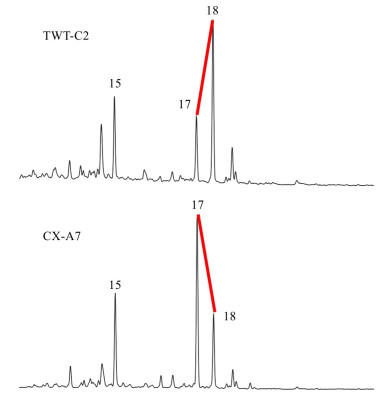
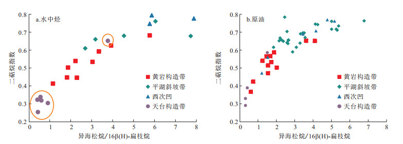
Sixteen light oil samples from Huangyan structural belt, Pingbei area and Ningbo structural belt in Xihu Depression were analyzed by geochemical analysis. The crude oil samples are rich in biomarkers related to the input of terrestrial higher plants, especially the tricyclic and tetracyclic diterpenes and their aromatization compounds derived from angiosperm, gymnosperms, and pteridophytes, while the content of biomarkers reflecting the input of aquatic plants are relatively low. The distribution of these high plant biomarkers between different local structures is obviously different, such as isopimarane/nC20, isopimarane/(isopimarane+16β(H)-phyllocladane), 1, 2, 5-trimethyl naphthalene/1, 3, 6-trimethyl naphthalene, and 1, 7-dimethyl phenanthrene/(retene+1, 7-dimethyl phenanthrene). These differences indicate that there are high contents of gymnosperms input, and low contents of pteridophytes and angiosperms input of crude oil from the Ningbo structural belt as well as the Pingbei area. However, crude oil from the Huangyan structural belt has more pteridophytes input and fewer angiosperms and gymnosperms input. In this study, whole oil gas chromatography-mass spectrometry analysis was used to develop a relationship between saturated hydrocarbons and aromatic hydrocarbons. The ratio of (isopimarane+1, 7-dimethyl phenanthrene)/(retene+16β(H)-phyllocladane) was proposed as an index to reflect the provenance of organic matter of light oil in Xihu Depression, and the positive correlation between the parameter values and whole oil carbon isotope values proves that the gymnosperms have the most important hydrocarbon-generating contribution to the crude oil in Xihu Depression.
Application of geostatistical inversion constrained by sequence framework in thin-bedded sandbody prediction
Liu Xiaochen, Lu Yongchao, Du Xuebin, Li Xiangquan, Lin Weibing, Zhang Jingyu, Feng Lin
2020, 39(3): 99-109. doi: 10.19509/j.cnki.dzkq.2020.0311
Abstract:
The spatial distribution of the sand reservoir in Xihu Depression is difficult to predict precisely by using traditional geophysical techniques, owing to the following two main reasons:1)The single-layer thickness of the sand reservoir is thin; and 2)Interbeds of sandstone and mudstone show rapid and frequent lateral lithofaices change.Based on geological data and geophysical techniques, the isochronous sequence stratigraphic framework of the Eocene Pinghu Formation in Pinghu slope belt of Xihu Depression was established.The sandbody distribution within the sequence stratigraphic framework was predicted by using geostatistical inversion.The result shows that Pinghu Formation can be divided into three 3rd-order sequences.The lower sandbody is characterized by large single layer thickness, good lateral continuity, and contiguous plane development.The middle part is composed mainly of mudstone, with the isolated sandbody and poor continuity.The upper part exhibits an increase trend in layer thickness in sandbody with fine lateral continuity.Comparison of the geophysical research with traditional geological research reveals that the vertical resolution of sandbody prediction results obtained by geostatistical inversion could reach a resolution down to 1-2 m.The results indicate that geostatistical inversion is an effective approach to solve the problem on precise lithofacies identification and spatial distribution prediction by using 3D seismic data in Xihu Depression, providing valuable guidance for the favorable reservoir prediction in the future.
Hydrocarbon origin and reservoir forming model of Wuyunting structure in Xihu Depression, East China Sea Basin
Diao Hui, Zou Wei, Li Ning, Qin Jun
2020, 39(3): 110-119. doi: 10.19509/j.cnki.dzkq.2020.0312
Abstract:
In recent years, the oil and gas exploration of the Wuyunting structure in the Pinghu slope belt of Xihu Depression of the East China Sea Basin has reported good commercial discoveries, but the fluid properties of wells A and B that have been drilled are quite different. Well A is a gas reservoir and well B is a reservoir. The hydrocarbon source, filling period and accumulation model of Wuyunting structure were analyzed by biomarker compound comparison, carbon isotope analysis and fluid inclusion analysis. It is believed that the Wuyunting structural oil is a normal mature crude oil, mainly derived from the local Ningbo 19 sub-sag, Pinghu Formation coal-series source rock. The upper part of Pinghu Formation is high-mature natural gas, mainly from the main source of the eastern main shoal of Ningbo 19 sub-sag, Pinghu Formation, and the middle section of Pinghu Formation. It is a normal mature natural gas, mainly derived from local source rocks. The fluorescence of the inclusions is light yellow oil and gas inclusions and colorless gas inclusions. The uniform temperature indicates that the Wuyunting structure mainly undergoes two phases of hydrocarbon charging, 2 Ma and nowadays. The Wuyunting structure is rich in oil and gas resources, and the accumulation process is complex. Based on the hydrocarbon supply mode and the transport system, it is divided into two accumulation models: "dual-source lateral late secondary type" and "single-source vertical transport late native type".
Response to astronomical forcing of sedimentary record in Xihu Depression, East China Sea Basin
Liu Yang
2020, 39(3): 120-128. doi: 10.19509/j.cnki.dzkq.2020.0313
Abstract:
In this study, we have investigated the third-order sequences interpreted by the previous researchers of Paleocene-Eocene in the East China Sea Basin, and believe that the interpretation of the third-order sequences is mainly based on the interpretation of seismic and lithologic changes, which is basically consistent with the previous interpretation of the stratigraphic stages, and cannot truly reflect the characteristics of the third-order sequences driven by the change of sea-level. This paper takes well BSH-1 and its adjacent well NB-25-2-1 in Xihu Depression, East China Sea Basin as the research objects and selects GR logging curve as the paleoclimate alternative index. Based on the theory of cyclostratigraphy, this study, combining with the previous stratigraphic research data, conducted spectrum analysis and time series analysis, and analyzed the astronomical cycle of the two wells. Then, the paper establishes an effective astronomical chronograph and discusses the slope cycle information.The relationship between the 1.2 Ma long period of amplitude modulation and sea level change and the development of the third-order sequence shows that the third-order sequence in East China Sea Basin is controlled by the stable 1.2 Ma slope amplitude modulation period. Finally, a set of absolute astronomical time scale and a set of third-order sequence division plan are formed.
Prediction of pressure distribution and formation mechanism in low exploration area: A case study of Xihu Depression, East China Sea Basin
Duan Modong, Ye Jiaren, Wu Jingfu, Tian Yang, Cui Yan
2020, 39(3): 129-139. doi: 10.19509/j.cnki.dzkq.2020.0314
Abstract:
The distribution of pressure was predicted in Xihu Depression, East China Sea Basin by combining with the existing measured drilling pressure, log data analysis results and seismic velocity spectrum geophysical data. The results show that there are two sets of pressure systems, normal pressure system and overpressure system in Xihu Depression. The overpressure is mainly developed in Huagang Formation and Pinghu Formation, and the formation gradually changes younger from west to east. Mudstone is also characterized by shallow atmospheric pressure and deep overpressure, but varies in different zones. The interface of overpressure is mainly located in the lower part of Huagang Formation and the upper part of Pinghu Formation. The characteristics of the interface distribution of the overpressure are mainly controlled by the formation, and the depth has little effect on the distribution of the interface. The overpressure zone of the key interface covers a good continuity and has a certain regional distribution direction. There are obvious differences in large scale faults, which play a certain role in transporting, dividing and destroying the accumulation of pressure. Under-compaction and hydrocarbon generation are the main factors that produce overpressure in Xihu Depression, but there are great differences in different areas.
Hydrocarbon migration and accumulation process of Hetaoyuan Formation in the northern gentle slope zone of Biyang Depression
Zhang Xin, Chen Honghan, Long Zhao, Liu Qiang
2020, 39(3): 140-149. doi: 10.19509/j.cnki.dzkq.2020.0315
Abstract:
In order to understand the distribution of oil and gas, this paper studies the oil migration and accumulation process of Hetaoyuan Formation in the northern gentle slope zone of Biyang Depression using the micro-fluorescence spectrum and fluid inclusion and the burial-thermal history of one-dimensional basin simulation, combined with the analysis of seismic structural attributes and sedimentary facies. The results show that three kinds of fluorescent color oil inclusions, orange, yellow-green and blue-green, are detected in the third member of Hetaoyuan Formation in the northern gentle slope zone, reflecting three episodes of oil with different maturities. The abundance of oil inclusions and the homogenization temperature and burial history curve of associated aqueous inclusions indicate that there are two stages (three episodes) of filling events in the northern reservoir. The first stage was small in scale, and occurred in the relatively low maturity orange yellow fluorescent oil at the end of fault depression and the second stage appeared in the yellow green and blue green fluorescent oil with higher maturity at the end of Miocene tectonic uplift. The fluid overpressure in the second stage filling shown by the paleopressure simulation of fluid inclusions suggests its relation to the tectonic compaction. The continuous overpressure caused by compression and the fluid potential difference increasing with the source rocks in the deep depression caused by the uplift of the northern strata provide a strong driving force for the second stage of oil and gas. The frequent fault activities, especially strike slip faults, caused the transformation of a single sand body transport along the stratain to a composite transport system of sand body transport along the strata+fault vertical transport, leading to the quick migration of crude oil to the Northern gentle slope zone. It is important to understand the tectonic uplift control of oil and gas migration.
Geochemical characteristics of stream sediments and ore prospecting prediction in Shihuigou area, Qinghai Province
Huang Wenbin, Luo Xianrong, Liu Panfeng, Zheng Chaojie, He Wang, Yang Xiaoxiao, Xiao Xiaoqiang, Wang Shenglong
2020, 39(3): 150-159. doi: 10.19509/j.cnki.dzkq.2020.0316
Abstract:
This paper makes a geochemical statistical analysis of 10 kinds of trace elements measured in stream sediments in Shihuigou area, and discusses the metallogenic potential of 10 kinds of trace elements using the variation coefficient of elements, the discrete characteristics of element enrichment and the superposition coefficient based on the survey of 1:50 000 stream sediments in Shihuigou area, Dulan County, Qinghai Province.The paper concludes that four trace elements, Au, Cu, Pb, and Zn have great metallogenic potential, and establishes the characteristics of element assemblage in the survey area by correlation analysis and factor analysis. A total of 3 ore element assemblages (Ag-Cu-Pb-Zn, Au-As-Sb, W-Bi-Hg) are divided.Through the contrast value anomaly method to circle, the combination anomaly in the study area is obvious, and the anomaly combination is better. Finally, according to the abnormal nesting results of the combined contrast value, three gold, copper, lead and zinc polymetallic prospecting targets (A, B, C) are selected in the study area.
Genesis of fibrous veins in the shales of Longmaxi Formation in Shizhu area, Eastern Chongqing
Huang Weilin, Feng Mingyou, Liu Xiaohong, Chen Bo, Zheng Jiang, Liu Tian
2020, 39(3): 160-169. doi: 10.19509/j.cnki.dzkq.2020.0317
Abstract:
Fibrous calcite veins (FCV) filled in microfractures in Lower Silurian Longmaxi Formation are widely found in the Eastern Chongqing of Southwestern China. The mechanism and time of fibrous calcite veins is elucidated by the combination of petrographic descriptions integrated with fluid inclusion, stable carbon and oxygen isotopic data and burial history with thermal history evidence. Field observations indicate that the syntaxial fibrous calcite veins are filled in black silty shale/argillaceous siltstone microfractures with bedding-parallel or subhorizon, with width of 0.1-4.0 cm and lateral extended distance of 0.5-8.0 m. Fibrous calcite crystals grow mainly in columnar and fibrous vertical wall rock and are mostly co-precipitated with quartz fibers. The surface of the crystal is clean and the pressure shadow, mechanical twin of calcite and serrated grain boundary between crystals can be seen locally. The fibrous calcites are dark red-orange under cathodoluminescence, and also exhibit low negative values of δ13C and extreme negative values of δ18O, respectively with an average of -1.549‰ and -12.654‰, meaning that calcites may have been obviously affected by the increase of pore-water temperature. Fluid inclusion analyses of two-phase aqueous inclusions in fibrous calcites suggest that calcites occurre at temperatures with an average of 159.5℃. It is inferred that the FCV may have formed during uplift in the Middle-Late Triassic tectonic movement due to fracture-controlled fluid migration and precipitation by syntectonic superhigh pressure and excretion of geofluids in second paleohydrologic system.
Characteristics of mineralization fluids and mineralization material sources of the Sedex-type Dairi Pb-Zn ore concentration area in Indonesia: Evidence from fluid inclusions and isotopic geochemistry
Zhang Haikun, Hu Peng, Cao Liang, Cheng Xiang, Zhan Mingguo, Pan Luozhong, Dai Yu, Pan Beihong
2020, 39(3): 170-178. doi: 10.19509/j.cnki.dzkq.2020.0318
Abstract:
The Dairi Pb-Zn ore concentration area, hosted by shale and displaying Sedex-type Pb-Zn mineralization of giant scale, is located in northwestern Sumatra, Indonesia.Systematic analysis of fluid inclusions and H, O, S and Pb isotopes was performed to probe its genesis.The results show that (1) the homogenization temperatures range from 189 to 315℃, with a peak at 220-240℃, indicating medium temperature for mineralization; (2)values of δ18OV-SMOW vary from +5.9‰ to +19.5‰, with an average of +16.6‰, implying a magma water-dominated mineralization fluid with minor addition of shallow water; (3)pyrites have positive δ34SCDT values from +25.49‰ to +26.36‰; (4)lead isotopes possess high μ values of 9.92-10.17(averaging 10.04) and ω values of 38.06-40.51 (averaging 39.26).It is indicated that the ores from Dairi formed at medium temperatures, having a fluid source dominated by magma water with minor addition of shallow water, a sulfur source comparable to ocean water and a single lead source from the crust.
Landslide susceptibility assessment based on multi-model fusion method: A case study in Wufeng County, Hubei Province
Lian Zhipeng, Xu Yong, Fu Sheng, Chen Lixia, Liu Lei
2020, 39(3): 178-186. doi: 10.19509/j.cnki.dzkq.2020.0319
Abstract:
Different landslide spatial prediction maps can be worked out from different landslide susceptibility models. It is efficient to choose the best optimal model or to integrate some models together in order to enhance the accuracy of landslide susceptibility. For the sake of testing the effectiveness of fusion models, the information model, the weights of evidence model and the frequency ratio model were used to predict the landslide susceptibility with the landslide controlling factors, such as slope, lithology, fault, river and road, in Yuyangguan Town, Wufeng County, Hubei Province. Then landslide susceptibility maps from three models were fused through normalized fusion method, principal component analysis fusion method and advantage fusion method. Comparatively, the accuracy resulting from advantage fusion method (90.3%) is highest among all that of other landslide susceptibility maps, including frequency ratio method (89.7%), normalized fusion method (89.3%), PCA fusion method (89.1%), weights of evidence mothed (87.7%) and information value method (87.6%). In the result of spatial agreement analysis, 68% area maps have the same class in the maps from advantage fusion method and PCA fusion method, decreasing the contingency and one-sidedness of single model. The study verifies the feasibility of the model fusion, and can provide a reference for landslide evaluation in the other geological environment.
Landslide susceptibility evaluation in Badong County based on weights of evidence method
Hu Yan, Li Deying, Meng Songsong, Sun Yiqing
2020, 39(3): 187-194. doi: 10.19509/j.cnki.dzkq.2020.0320
Abstract:
Because of its special geographical location and special geological conditions, Badong County becomes a prone zone of geological hazards, especially landslide disasters. It is necessary to research landslide susceptibility evaluation, because of its serious threat to the development of Badong County.First, we extracted the influence factors of the formation and development of landslide respectively and divided the evidence layer on GIS.The influence factors include the formation lithology, geographic and geomorphic conditions, geological structure, and hydrogeological conditions.The weights of evidence method was applied to calculate the weights of each layer of evidence and posterior probability respectively.Then, distribution chart of landslide susceptibility was generated by overlaying posterior probability of evidence layer of each unit. Finally, according to Natural Breaks law, the researched region was divided into five categories:extremely high, high, moderate, low, and extremely low by landslide susceptibility.The sum area of extremely high and high is about 33% of the total area and about 86% of existing landslides occurred in extremely high prone area and high prone area.The result shows good by using the success rate curve test that division.
Weathered layer thickness mapping method based on high resolution satellite remote sensing technology
Qin Xuwen, Tang Zhuang, Chen Weitao
2020, 39(3): 195-201. doi: 10.19509/j.cnki.dzkq.2020.0321
Abstract:
The thickness of the weathered layer at the regional scale is one of the important factors that restrict the geological engineering construction, the military capacity of the land, and the underground military construction of the shallow surface. Traditional methods often require extensive field surveys and field sampling, which are inefficient and cannot be completed in areas inaccessible.Therefore, the use of high resolution satellite remote sensing technology to carry out regional scale weathered layer thickness mapping research is very important. Based on the field survey, GF-2 remote sensing data were used to obtain lithology, plant community and land cover type distribution map of the study area, and the topographic map based on ASTER GDEM data was obtained. Then, based on the cloud model theory, the slope, lithology and land cover type are used as influencing factors, and the weathered layer thickness map of the study area is obtained by comprehensive evaluation. The results are in good agreement with field verification data, with the accuracy up to 81.69%.
Spectral characteristics and correlation of heavy metal and vegetation cover stress in Fanshan copper-molybdenum
Shi Chao, Huang Chao, Li Shu, Nie Feng, Wang Xueping
2020, 39(3): 202-210. doi: 10.19509/j.cnki.dzkq.2020.0322
Abstract:
Hyperspectral technology has high precision in the fine detection of ground objects, and can realize the extraction of weak information. In this paper, hyperspectral remote sensing technology was used to study the correlation between heavy metals, copper and lead, and the spectral stress of covered vegetation in the high-vegetation area of Fanshan, Fujian. By comparing and analyzing the spectral characteristics of typical vegetation in mining areas and non-mineral areas, this paper indicates that the typical vegetation in the mining area is subjected to heavy metal element stress to different degrees, causing the spectrum to mutate. Based on the analysis results, the paper established the mathematical model of correlation between heavy metal and vegetation spectral stress based on vegetation geochemical data, and proposes the correlation between heavy metal and vegetation cover stress. According to the model, the spatial distribution of metal elements can be obtained, and finally the application of high-spectral remote sensing in geological prospecting in high vegetation coverage areas is overcome.
Coring drilling technology of coral-reef Quaternary overburden in South China Sea
Song Jiwei, Jiang Guosheng, Li Yong, Ban Jinpeng, Hao Haiyang
2020, 39(3): 211-215. doi: 10.19509/j.cnki.dzkq.2020.0323
Abstract:
The coral-reefs in the South China Sea own huge resource potential and scientific research value.Coral-reef's Quaternary overburden is composed of the loose accumulation of coral skeleton and coral sand.The poor cementation coral-reef covering layer makes coring and well completion much difficult.Based on the construction practice of hundreds of drilling holes in South China Sea Islands, the technology of "casing continuous follow-up dry coring drilling technnology" is summarized. The key point of this technology is the four-step cycle operation, which can be called "four-step method".It can ensure that core recovery rate of the coral-reef Quaternary overburden can reach above 95% with basically guaranteeing core original state.Also it can safely drill into the formation without using mud protection wellbore in the Quaternary overburden of coral-reef and achieve the goal of avoiding blockage of formation water passage and meeting the requirements of pumping tests.The present research results have significant reference for coral reef drilling.
Design of virtual training platform for construction machinery based on Stewart
Zhao Quan, Wen Guojun, Liu Haojie, Wang Yudan, Liu Qingtao
2020, 39(3): 216-221. doi: 10.19509/j.cnki.dzkq.2020.0324
Abstract:
In order to enhance the virtual training immersion effect of construction machinery, a six-degree-of-freedom(6-DOF) seat platform is developed based on Stewart 6-DOF mechanism, including a parallel motion mechanism, a hydraulic pump station, and a PLC control system. The positional parameters of the motion platform are determined by the driving characteristics of the construction machinery, and the data interaction that conducted with the upper computer software is established by MATLAB. After the kinematics inverse solution is calculated, the length change value of each hydraulic cylinder is obtained. The PLC controller processes the instructions and sends the commands to control the flow of the electro-hydraulic proportional valve, and drive the six parallel hydraulic cylinders to expand, so that the moving platform presents different position and posture. Based on the above principles, a physical platform is built and tested according to the driving characteristics. The test results show that the platform could simulate the posture of construction machinery under different working conditions, so as to improve the immersion of virtual trainers.
Design of virtual training system for core drill based on Unity3D
Hu Zifei, Wen Guojun, Wang Yudan, Zhao Quan, Xia Yu
2020, 39(3): 222-226. doi: 10.19509/j.cnki.dzkq.2020.0325
Abstract:
Large-scale core drill is expensive, complicated in operation and dangerous to manipulators, leading to the difficulty in traditional training techniques for skilled technicians. What's more, the leap type of traditional training of theoretical learning and practice on-board increases the risk of rig damage and scrap, also raises the threshold of trainers. Therefore, this paper proposes a design scheme of core drill training system based on Unity3D, and taking XY-4 core drill as an example, which is modeling by SolidWorks and Maya. The software system is developed with Unity3D, which is able to simulate real-life work scenarios, and gives system users an immersive feeling. The training system sets up four learning scenarios: cognitive video learning, operational essentials learning, single-step training, and overall training. In this system, operational knowledge is interlocked, with people and scenes blended together.