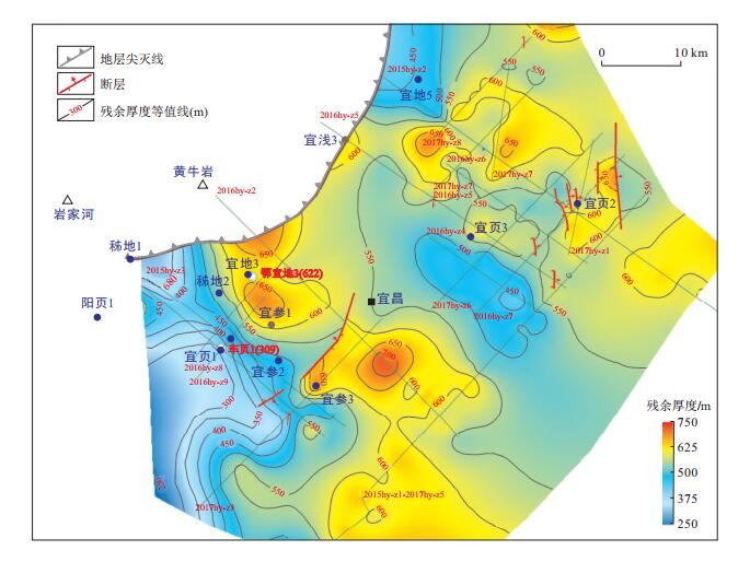
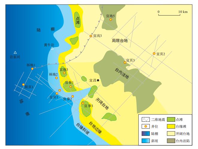
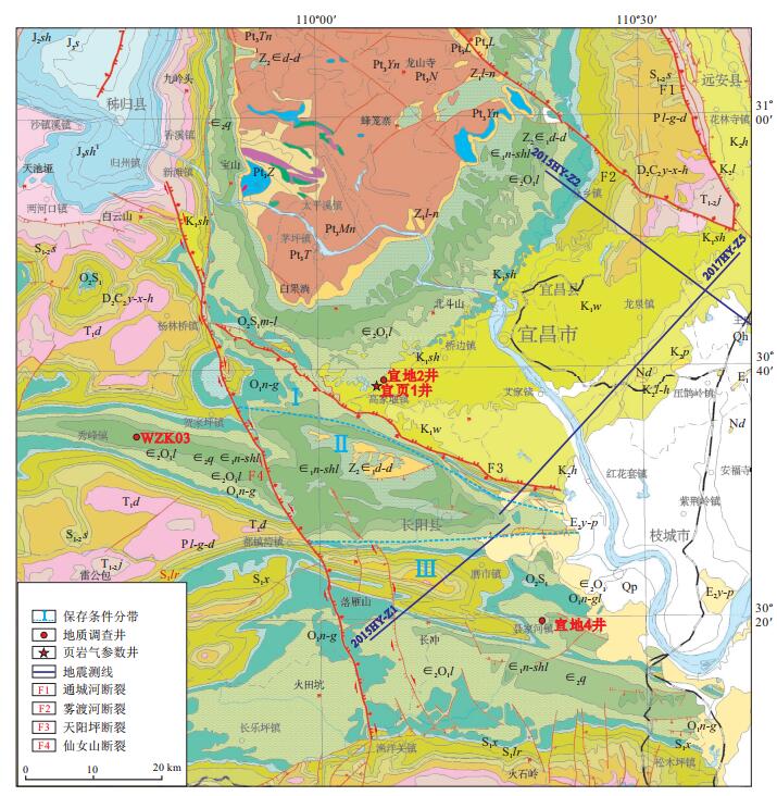
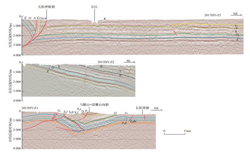
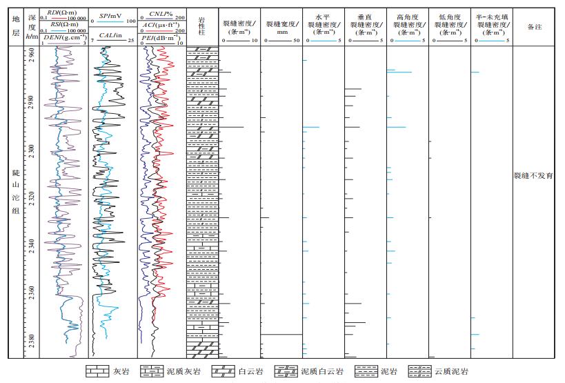
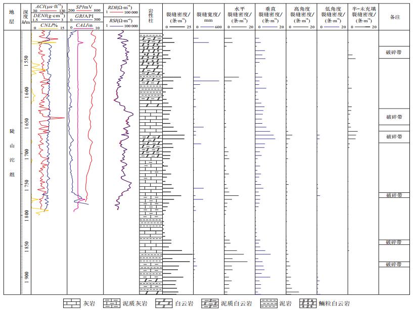
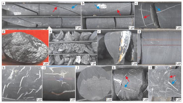
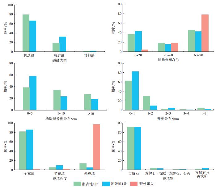
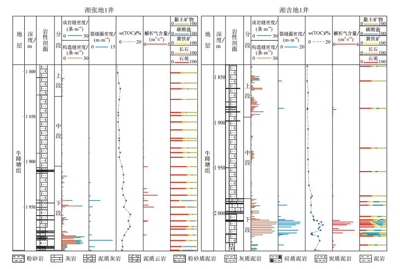
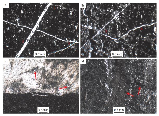
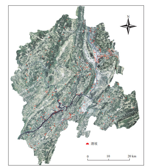
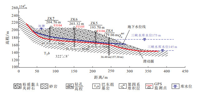
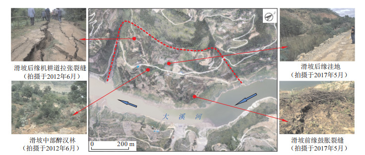
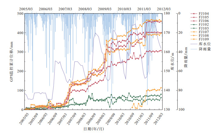
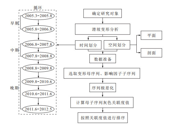
2020 Vol. 39, No. 2

Display Method:
2020, 39(2)
Abstract:
Discovery and geological significance of Nanhua-Sinian fault-depression, Yichang slope
Yue Yong, Chen Xiaohong, Zhang Guotao, Luo Shengyuan
2020, 39(2): 1-9. doi: 10.19509/j.cnki.dzkq.2020.0201
Abstract:
In the slope of Yichang, the drilling of the Lower Cambrian Shuijingtuo Formation and Lower Sinian Doushantuo Formation with high gas shale in the southern complex structural area announces significant discovery of ancient shale gas.The Nanhua-Sinian tectono-sedimentary framework in Yichang slop is key to understanding the basin tectonic attribute and ancient shale gas accumulates.Based on the previous geological research results, characteristics and seismic data of Nanhua-Sinian were observed and analyzed.It is shown that there are two fault-depression types, Inter-cratonic typeⅠof Yichang and cratonic margin transition zone typeⅡof Changyang.After experienced four evolutionary stages, early fault, middle cryogenian, fault-depression transition and late depression, the fault-depression control platform slope facie of type Ⅰ, platform inner depression facie of type Ⅰ, and shelf sedimentary facies of type Ⅱ, which belong to Doushantuo and Dengying-Shuijintuo Formations structure sedimentary area, relatively developed organic shale.It is concluded that the zones of type Ⅰ and type Ⅱ, deep fault-depression are shale gas scale areas of source rock-reservoir of Doushantuo and Shuijintuo Formations.In addition, type I is the favorable gathering place of the natural gas reservoir, beside source rock, Dengying Formation platform edge beach.
A comparative study of shale gas preservation conditions on both sides of Tianyangping fault in Yichang area
Liu An, Chen Xiaohong, Li Peijun, Zhou Peng, Li Hai, Cai Quansheng, Luo Shengyuan
2020, 39(2): 10-19. doi: 10.19509/j.cnki.dzkq.2020.0202
Abstract:
The shale gas content is different in different shale gas survey wells and parameter wells, from both sides of Tianyangping fault in Yichang, Middle Yangtze area. The reasons for the difference of preservation conditions are studied from the aspects of shale tectonic deformation, fracture character and paleo-fluid activity. The following results were obtained: ①Because of the pillar effect of Huangling uplift, the Yichang slope is a simple monoclinic structure with gentle occurrence in the north of Tianyangping fault, and on the other hand, faults and folds are well developed and the occurrence of strata varies greatly of northern part of Yidu-Hefeng anticline in the south of Tianyangping fault. ②Typical wells illustrate that fractures and fracture belts of shale are highly developed in the north of Tianyangping fault, and are the channels for shale gas to escape in the north of Tianyangping fault, while fractures are rare in the south of Tianyangping fault. ③Paleo-fluid reveals that more fractures in the early stage of closed system of shale and fewer in the later stage in the north of Tianyangping fault, while more fractures in the later stage lead to the infiltration depth of ancient meteoric water, over 3 500-4 000 m in the south of Tianyangping fault, and the sealing capacity of the shale get worse. ④The conclusion is that exploration should spread to the Badong-Daye ramp interference fringe, in the east and west of Yichang slope; and there are more exploration risks to spread to the south of Tianyangping fault because of the strong tectonic deformation, and worst protection condition in the north end of Yidu-Hefeng anticlinorium.
Origin of siliceous rocks in west Hunan and Hubei Provinces during Late Ediacaran-Early Cambrian, and its geological significance of shale gas
Wei Kai, Chen Xiaohong, Wang Chuanshang, Liu An, Zeng Xiongwei, Li Zhihong
2020, 39(2): 20-30. doi: 10.19509/j.cnki.dzkq.2020.0203
Abstract:
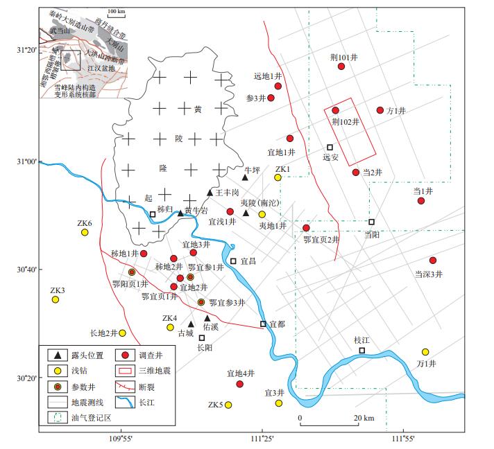
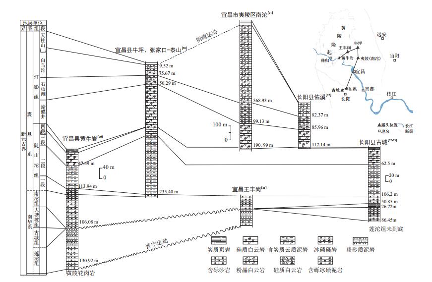
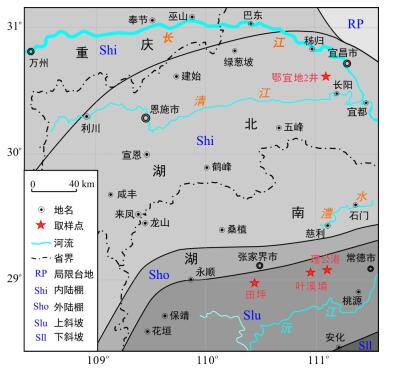
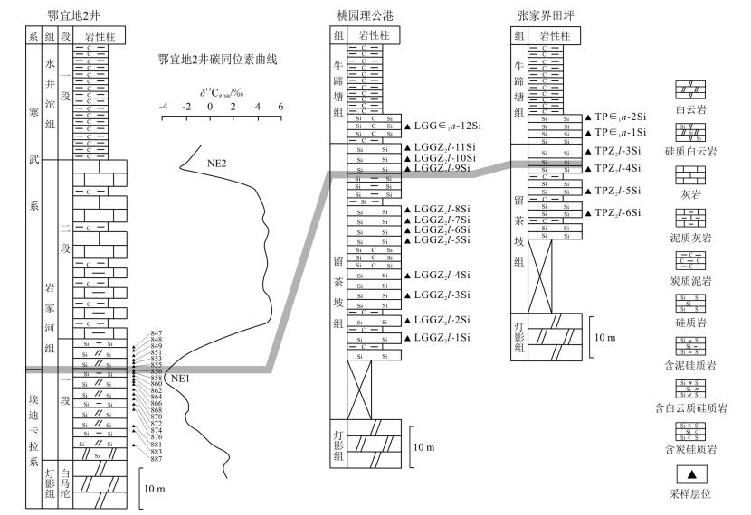
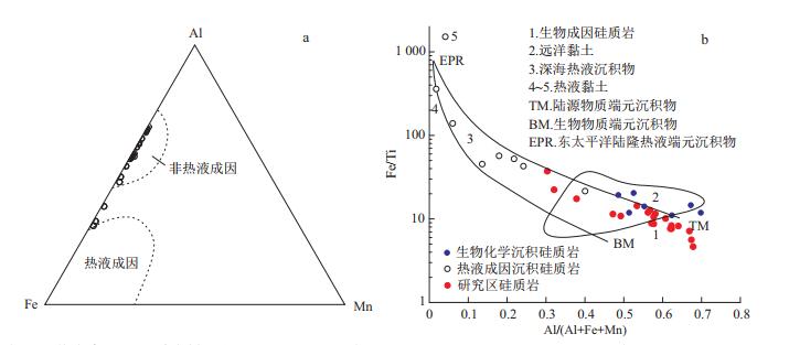
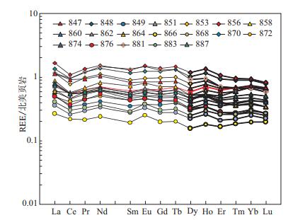
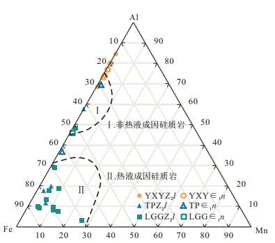
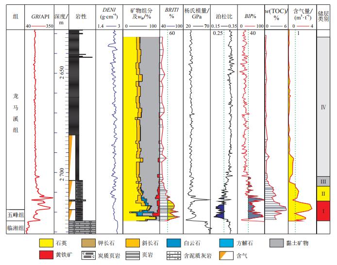
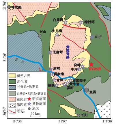
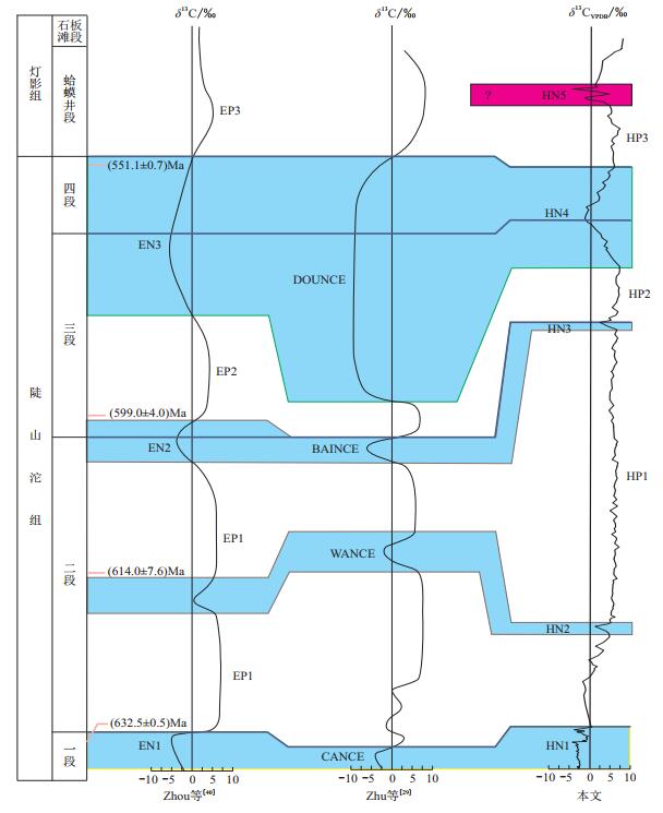
Followed by the major breakthrough of shale gas in Shuijingtuo Famation of Yichang, Hubei Province, the organic-rich shale in Lower Cambrian has received much wider attention. In order to find out the internal relationship of the organic-rich shale and the underlying siliceous rocks, we have made a systematic study of the west Hubei and Hunan Provinces, including Yanjiahe Formation of YIDI-2 Well, Liuchapo-Niutitang Formation of Taoyuan and Zhangjiajie area. Based on the analysis of major elements and rare earth elements, we discuss in the paper the different origins of siliceous rocks during Late Ediacaran-Early Cambrian, as well as their significance of shale gas. The conclusions are reached: ①The Al/(Al+Fe+Mn) values of YIDI-2 Well are between 0.30-0.68, close to the biogenic origin. In the Al-Fe-Mn and Fe/Ti-Al/(Al+Fe+Mn)decision diagrams, the sample points are also in the non-hydrothermal area. There is no obvious Eu anomaly but flat partition curves in REE, with LaN/YbN values between 1.01-1.81, indicating the lack of hydrothermal activities and the origin of continental margin. Therefore, the siliceous rocks in Yanjiahe Formation of YIDI-2 Well are mainly of nonhydrothermal origin. ② In the Taoyuan and Zhangjiajie area of West Hunan Province, Al/(Al+Fe+Mn) values of Liuchapo Formation are between 0.03-0.19, and the sample points are close to the Fe in the Al-Fe-Mn diagram. Combined with the obvious Eu anomalies and left-inclined partition curves in REE, it is concluded that the siliceous rocks in Liuchapo Formation are hydrothermal origin. However, it has changed into non-hydrothermal origin for the siliceous rocks in Niutitang Formation, which can be inferred by the larger values of Al/(Al+Fe+Mn) (0.29-0.70), the unconspicuous Eu anomalies and flat partition curves of REE. ③During the later period of Ediacara, due to the short distance to the hydrothermal vents, a set of hydrothermal-origin cherts are developed on the west Hunan slope. As for the Yichang area in the restricted basin, because of the blocking of silceous hydrothermal fluid, a set of dolostone is deposited. During the Early Cambrian, followed by the climate warming, sea-level rising and the sea water being connected, a set of biogenic chert is developed both in west Hunan slope and Yichang area. We conclude that the hydrothermal activities that occurred during Late Ediacaran should be of great significance for the generation of organic shales in Shuijingtuo or Niutitang Formations, because of the large supply of nutrient elements, such as phosphorus, for the flourishing of marine organism. Combined with the exploration results of Cambrian shale gas in South China, we consider that the nonhydrothermal siliceous shales are probably the favorable zones, and about to be the main direction of future exploration after more similar discoveries.
Development characteristics and major controlling factors of shale fractures in the Lower Cambrian Niutitang
Miao Fengbin, Peng Zhongqin, Wang Zongxin, Yu Yuning, Ma Yong, Sui Zhiheng
2020, 39(2): 31-42. doi: 10.19509/j.cnki.dzkq.2020.0204
Abstract:
Based on outcrop, coring, thin section and the SEM observation and statistics of shale fracture characteristics in the Lower Cambrian Niutitang Formation, western margin of Xuefeng uplift, as well as the corresponding sample analysis test data, this paper analyzes in detail the development characteristics and major controlling factors of shale fracture in Niutitang Formation and the relationship between fracture development and gas content. The results indicate that macro fractures in Niutitang Formation are dominated by structural fractures, such as high dip-angle shearing fractures, low dip-angle slip fractures and some extensional fractures. Structural fractures are mainly formed in 6 stages. Among them the high-angle shear fractures in first stage are mostly developed, and the predominant orientations of fractures are NWW, NNW-near SN and NE directions. The diagenetic fractures are fewer than structural fractures. The micro-fractures mainly include interlayer and bedding fractures. The macro fractures in the core are mostly filled, and the filling degree of the later fractures is lower than that of the earlier fractures. The fracture development is influenced by many factors, such as tectonism, lithology and mineral composition, thickness, organic carbon content, diagenesis and high fluid pressure, among which structural stress and structural position are the main controlling factors. Regional structural stress determines the nature and overall development characteristics of fractures. Local structural stress and structural position make the distribution of fractures different. Fractures are more developed in the structural position with relatively concentrated stress, large stress gradient and strong deformation. In addition, shale with high content of brittle minerals, small thickness of single layer, late diagenetic stage, high content of organic carbon and high fluid pressure has well fracture development.The development of macro fractures and a large number of associated micro-fractures in Niutitang Formation effectively improve the reservoir permeability of shale and thus play an important role in improving gas content.
Occurrence characteristics and depositional model of graptolites from the black shale in the Upper Ordovician Wufeng Formation and Lower Silurian Longmaxi Formation
Cai Quansheng, Chen Xiaohong, Wang Chuanshang, Zhang Baomin, Han Jing, Zhang Guotao, Liu An, Luo Shengyuan, Li Hai, Zhang Miao, Li Peijun, Li Yangui
2020, 39(2): 43-53. doi: 10.19509/j.cnki.dzkq.2020.0205
Abstract:
Based on the pervious researches, the occurrence characteristics and depositional environment of graptolites from the black shale of the upper Ordovician Wufeng Formation and Lower Silurian Longmaxi Formation in the Yichang area are analyzed in detail through integrating mineral and geochemical data. The results show that the occurrence characteristics of graptolites from the black shale in the Wufeng and Longamxi Formations are different, with graptolites abundance decreasing gradually from the lower part to the upper part. Carbonaceous shale always has a lot of graptolites, and most of graptolites are disordered except some of them are stored regularly. The graptolites abundance in greyish-green shale and black siliceous shale is low and most of graptolites are composed of fragments smaller in the black siliceous shale. Graptolite diversification in the black shale also shows regular variations, and the graptolite diversification in the Hirnantian is much lower than that in the Aeronian and Katian. Comprehensive analysis indicates different graptolite occurrence characteristics usually have various TOC, surrounding rock properties, oxidation-deoxidation conditions, palaeoenvironment and hydrodynamic conditions. The shale with rich graptolites abundance often has high value of TOC, with their quartz content usually ranging from 40% to 60%. Graptolites can be deposited both in weak oxidation and deoxidation conditions, but the deoxidation environment is much more favorable for graptolites sedimentation and preservation. The vertical variations in graptolite diversification and graptolites abundance are obviously influenced by palaeoenvironment, and the lower graptolite diversification and massive disappearance of graptolite in the Hirnantian are caused by glaciation and sea-level changes. Disordered graptolites are the results of suspended sedimentation, while the graptolites with directional alignment indicate reformation by ocean current. Finally, based on the different graptolite occurrence characteristics and their sedimentary geological significance, their sedimentary environment is discussed in detail and the depositional model of graptolites in the Wufeng and Longamxi Formations is proposed.
Reservoir characteristics and brittleness evaluation of Wufeng Formation-Longmaxi Formation shale in Yichang area, Western Hubei Province
Chen Lin, Chen Xiaohong, Zhang Baomin, Zhang Guotao, Li Hai, Lü Rong, Lu Yongchao, Lin Weibing
2020, 39(2): 54-61. doi: 10.19509/j.cnki.dzkq.2020.0206
Abstract:
Based on the data of X-ray diffraction (XRD) whole rock analysis, X-ray diffraction clay mineral analysis, physical analysis, gas-bearing test and geophysical logging of the Wufeng Formation-Longmaxi Formation shale in Yichang area, the development characteristics and brittleness characteristics of the shale reservoirs in the area are studied and evaluated comprehensively. The results show that the shale of Wufeng Formation-Longmaxi Formation in Yichang area is mainly composed of quartz, clay minerals, feldspar, dolomite, calcite and pyrite, and has the characteristics of high silica, and low clay in the bottom and low silica and high clay in the upper layer. The shale porosity mainly ranges from 1.01% to 1.77%, with an average of 1.29%, permeability mainly ranges from 0.001×10⁻³ μm2 to 0.843×10⁻³ μm2, average 0.234×10⁻³ μm2, belonging to low porosity and ultra-low permeability reservoir. The shale gas content in Lower Wufeng Formation-Longmaxi Formation whose thickness can reach 20 m is generally greater than 1 m3/t. The results of brittleness analysis by brittle mineral content method show that the brittleness index of shale varies from 39.6% to 89.6%, with an average of 55.4%. The brittleness index of shale at the bottom of 10 m is more than 60%, which is beneficial to the formation of complex fracture network system after reservoir fracturing. The results of brittleness analysis by elastic parameter method show that the Young′s modulus of the Wufeng Formation-Longmaxi Formation shale is mainly between 25.2 GPa and 67.5 GPa, with an average of 38.9 GPa; the Poisson′s ratio is mainly between 0.177 and 0.327, with an average of 0.297, and the brittleness index is mainly between 8.5% and 97.3%, with an average of 33.2%. The 13 m shale at the bottom has typical high Young′s modulus, low Poisson′s ratio and high brittleness index. The comprehensive evaluation results of shale brittleness indicate that the 9 m shale of the bottom of Wufeng Formation-Longmaxi Formation has the relative optimum Young′s modulus and Poisson′s ratio. Its brittleness belongs to medium and high degree. The 9 m shale has strong fracture making ability and good fracturing ability. The whole shale is divided into 4 sections of modifiable reservoir. The shale section of 2 714.4-2 723.4 m at the bottom has the characteristics of relatively minimum Poisson′s ratio, best gas content, best brittleness and high organic matter content, which constitutes the optimal reconstruction section in the study area.
Carbon isotope characteristics and organic matter development of the Ediacaran in the southeastern margin of the Huangling anticline, western Hubei
Zhou Peng, Chen Xiaohong, Wei Kai
2020, 39(2): 62-73, 93. doi: 10.19509/j.cnki.dzkq.2020.0207
Abstract:
The carbon isotope and TOC data of the Ediacaran in the southeastern margin of the Huangling anticline have been obtained by the testing analysis of core samples from the Well EYD5. The carbon isotope curves of the Ediacaran Doushantuo Formation to the Hamajing Member of the Dengying Formation have been established, and 4 negative excursions and 2 positive excursions are recongnized, as well as 1 negative excursion and 1 positive excursions interval in the Hamajing Member of the Dengying Formation. This can be compared with the reported curves from regional sections during this period. In this paper, the carbon isotope markers within the Ediacaran Doushantuo Formation to the Hamajing Member of the Dengying Formation for stratigraphic correlation are summarized, and the TOC variation in the Doushantou Formation has no relationship with carbon isotope anomaly, but the organic-rich shale usually has continuous negative value of delta δ13C.
Comparison in petroleum geology between Biyang Depression and Nanyang Depression in Nanxiang Basin and its exploration significance
Li Zhi, Zhang Zhiye, He Dengfa, Li Yan, Li Teng
2020, 39(2): 74-84. doi: 10.19509/j.cnki.dzkq.2020.0208
Abstract:
Biyang Depression and Nanyang Depression are secondary structural units of Nanxiang Basin. They are separated by Tanghe low uplift and have similar effective exploration areas. However, the resources, proven geological reserves and oil productions of the two depressions are quite different. Based on the seismic, drilling, logging, geochemical data and current exploration knowledge of the two depressions, we compared their similarities and differences from the prospective of geotectonics, basin analysis and petroleum geology. We have found they share the following points : geotectonic setting, tectonic evolution stages, depression plane modality and stratigraphic systems. However, they are different more remarkably in basement properties, boundary fault characteristics, subsidence characteristics, geothermal characteristics, source rock characteristics, sedimentary system, reservoir physical properties, source-reservoir-seal rock associations, trap conditions, petroleum accumulation mechanisms and preservation patterns. Among these aspects, the overwhelming important factors for controlling the oil and gas distributions are the basement properties and geological framework that control the accumulation factors and effects. The analogy of petroleum geological characteristics shows that the exploration degree in Nanyang Depression is relatively low. Our understanding of the successful exploration experience of Biyang Depression, our geological knowledge, and key exploration technologies, and multi-domain, multi-level, and multi-reservoir type stereoscopic exploration, suggests that the depression still have great exploration potential.
Detection of concealed ore bodies in Jiajika rare metal orefield using geogas prospecting technology
Wang Qiubo, Liang Bin, Liu Ting, Xu Zhiqiang, Geng Yan
2020, 39(2): 85-93. doi: 10.19509/j.cnki.dzkq.2020.0209
Abstract:
An experimental research was conducted on two concealed deposits, X03 and Shaotangou, in Jiajika rare metal orefield. The geogas was collected by an air sampler, and the particles in the gas were captured by 5% dilute nitric acid solution. The results show that continuous anomalies of Li, Be, Rb, Cs, Na and B are observed from the two deposits, and can be used to explore the ore bodies 30-100 m below the earth surface. On Line 35 of X03 ore body, there is no correlation between the content of the mineral elements in the geogas and its total content in the soil. This indicates that the anomalies are formed by the elements in the geogas, not in the soil. Hence, the mineralization information is included in the geogas. The anomalies of the elements in the geogas show in top halos, located over the concealed deposits. Based on the study of metallogenic geological conditions and geophysical data, such as electrical method, drilling engineering can be arranged above the anomalies of elements in geogas for drilling verification.
Brittleness evaluation method of tight sandstone based on Adam-neural network: A case study of a block in Gaobei slope, Nanpu Sag
Wan Liming, Wu Jun, Lu Junkai, Liu Yi, Chen Mian
2020, 39(2): 94-103. doi: 10.19509/j.cnki.dzkq.2020.0210
Abstract:
The brittleness evaluation of tight sandstone is of great importance in sweet point prediction and fracturing stimulation. To clarify the mechanics mechanism of brittleness and better the accuracy of the brittle mineral analysis, we propose an Adam-neural network brittleness evaluation method, which takes the mechanical property, mineral component and rock maturity into account. Firstly, we conducted triaxial mechanical experiments on 27 samples from the northern Nanpu Sag, and analyzed the stress-strain curve so as to obtain the brittleness index based on Rickman method. Secondly, according to the X-ray diffraction, we obtained the content of clay and non-clay, which respectively reflect the rock maturity and brittle component. Then we used an advanced Adam algorithm to form a neural network evaluation model, setting the Rickman brittleness index as objection function and mineral content as training parameters. Finally, we validated the model accuracy with the logging curve. The result shows that the brittle minerals of the region are mainly quartz and feldspar. The rock shows medium brittleness but strong anisotropy. This result is consistent with the brittleness index calculated by logging data. With all the mechanical, geological and mineralogical factors combined, this Adam-neural network model can help obtain more accurate brittleness index in a broader area, which provides a good basis for fracturing parameter optimization and target layer selection.
Development characteristics and influence degree zoning of carbonate rock collapse in Nanzhang and Baokang Counties
Liu Wanli, Yan Echuan, Dai Hang, Wei Pengfei, Li Lihua
2020, 39(2): 104-112. doi: 10.19509/j.cnki.dzkq.2020.0211
Abstract:
In recent years, the carbonate rock distribution areas in Nanzhang and Baokang Counties, Hubei Province have collapsed frequently, causing serious casualties and economic losses. Based on the data of 32 carbonate rock collapse obtained from the detailed investigations of 1:50, 000 geological disasters in two counties, this paper summarizes the development characteristics of the collapses from the perspectives of time and space distribution, scale characteristics, development stratigraphy and failure mode. According to the statistical result, the paper summarizes the collapses into five types. Then, using partitioning software and guided by the theory of the impact degree partition, the paper divides the carbonate rock distribution areas into directly affected areas and non-directly affected areas according to the scope of impact and the degree of damage. Subsequently, corresponding collapse prevention measures are proposed for different affected areas. Finally, the Tangchi gorge collapse in Baokang County is selected as a typical example for the analysis of the development characteristics of collapse, a more targeted prevention measures are proposed. The research result in this paper can systematically reveal the development characteristics of the same type of collapse or potential collapse points, and then guide their early identification and prevention. Thus, this has practical significance for raising awareness of disaster reduction and prevention.
Landslide susceptibility evaluation of Sinan County using logistics regression model and 3S technology
Hu Tao, Fan Xin, Wang Shuo, Guo Zizheng, Liu Aichang, Huang Faming
2020, 39(2): 113-121. doi: 10.19509/j.cnki.dzkq.2020.0212
Abstract:
The Sinan County of Guizhou Province, due to the specific and complex physical geography and geological conditions, is seriously affected by the landslide hazards. Hence, it is very necessary to conduct regional landslide susceptibility evaluation for landslide prediction and prevention in the area. This study uses 3S technology:remote sensing (RS), globe position system (GPS) and geographic information system (GIS), to evaluate landslide susceptibility based on the logistic regression (LR) model. The 3S technology is applied to obtain the landslide inventory, condition factors of landslides and other related basic data in Sinan County. About 308 landslides and ten affecting factors are acquired digital elevation model (DEM), slope, aspect, profile curvature, rock types, buffer of fracture lines, modified normalized difference water index (MNDWI), distance to river, normalized difference vegetation index (NDVI) and normalized difference building index (NDBI), using the 3S technology. Then based on the correlation analysis, LR model is used to calculate the landslide susceptibility indexes and map these indexes. Results show that, the area under the curve (AUC) of receiver operating characteristic curve (ROC) is 0.797 using LR model. The landslide distribution characteristics of Sinan County are accurately predicted by the LR model. In addition, the high and very high susceptible areas are mainly distributed in the areas where the DEM are higher than 600 m. In these areas, the slope are relatively great and the rocks are soft. The low and very low susceptible areas are mainly distributed in the areas where the DEM are high, the slopes are relatively low and the rocks are of hard rock class.
Deformation characteristics and evolution simulation of the Maliulin landslide in the Three Gorges Reservoir area
Yang Beibei, Yin Kunlong, Liang Xin, Zhao Haiyan
2020, 39(2): 122-129. doi: 10.19509/j.cnki.dzkq.2020.0213
Abstract:
The deformation characteristics of reservoir landslides are more complicated under the combined effect of water level fluctuation and rainfall. Taking the Maliulin landslide in the Three Gorges Reservoir area as a case study, this paper studies the deformation and evolution characteristics of the landslide according to field investigation, drilling records, deep displacement monitoring and deformation simulation. The results indicate that a secondary shallow sliding surface is detected between clay layer and rock-block layer, which controls its current activities. This phenomenon is mainly caused by the differences of landslide material composition. The Si (Sf) parameters shows that the sliding zone of the Maliulin landslide has not been totally destroyed and the landslide keeps creep deformation at present. The reservoir water level fluctuation can be divided into six periods according to its annul variation. The landslide keeps stable during water level slow drawdown period but deforms intensely during the periods of rapid drawdown and low water level. During the periods of reservoir water level rapid rise, slow rise and high water level, the landslide has mere deformation. It should be noted that the direct effect of rainfall and its indirect effect through reservoir water level fluctuation leads to intense deformation and annual minimum factor of safety for the landslide. More early warning work can be implemented for the Maliulin landslide during the period of low water level.
Effect of repeated infiltration on permeability characteristics of remolded loess
Ren Xiaohu, Xu Qiang, Zhao Kuanyao, Ju Yuanzhen, Du Pengchuan
2020, 39(2): 130-138. doi: 10.19509/j.cnki.dzkq.2020.0214
Abstract:
Long-term irrigation infiltration in Heifangtai, Gansu Province, destroys the original structure of loess, changes the particle gradation of loess at different depths, and affects the properties of the soil. In order to study the effect of repeated irrigation infiltration on slope, this paper studies the influence of repeated infiltration on the permeability of loess in Heifangtai, by indoor soil column penetration test, and the regularity and mode of fine particle migration in loess under osmosis. The following conclusions are reaches: ①The hydraulic gradient has little effect on the permeation rate and the dry density has a greater influence on the percolation rate. With the increase of the infiltration times, the permeability of the remolded loess becomes weaker. ②Under the action of seepage force, the loess shows the phenomenon of fine particles moving along the seepage direction, and the fine particles gather most in the upper part of the soil column. ③The factors affecting the migration of fine particles are: hydraulic gradient, dry density and penetration times; and the migration of fine particles is positively correlated with hydraulic gradient and penetration number, negatively correlated with dry density. The hydraulic gradient is the main factor affecting the migration of fine particles. ④During the infiltration process, the fine particles are continuously transported, and finally the pores in the soil are filled, and so the permeability of the loess is lowered.
Seepage and stability of the colluvial landslide on the back hill of Qingshi Town Government under rainfall
Lu Cao, Yan Echuan, Zhang Yu, Tan Zhaorui, Zou Hao
2020, 39(2): 139-147. doi: 10.19509/j.cnki.dzkq.2020.0215
Abstract:
Taking the colluvial landslide of the back hill of Qingshi Town Government in Huanggang area as an example, this paper used finite element method to study the transient volumetric water content and pore water pressure of unsaturated soil based on the analysis of its engineering geological characteristics and geological structure characteristics.The Janbu method considering pore water pressure was used to calculate the effect of rainfall on the safety factor of the colluvial landslide. The results show that:①Rainfall infiltration leads to the increase of pore water pressure in the slope, and then the shear strength of the sliding surface to decrease, and so the safety factor decreases gradually. In the early stage of rainfall, the shear strength on both sides decreases faster than that in the central part. At the end of the period, the rate of decline in shear strength is significantly faster than that on both sides.②The change in safety factor shows a slow decline at the rate of 0.008/d for the first 19 d and a slow decrease at the rate of 0.03/d for 19-30 d. After 30 d, the descending speed decreases, and no change occurres after 36 d. Among them, the change of shear strength on both sides of 0-11 d contributes more to the change of overall stability than that of the central part. The contribution of shear strength change to the overall stability of 19-36 d is greater than that of the central part.③During the rainfall infiltration, groundwater flows from the surface and sides of the slope to the middle of the slope, and the negative pore water pressure area is continuously compressed to the central part. The groundwater changes in the central area are restricted by the two sides and the upper layer. The volumetric water content and the pore water pressure change are relatively lagging.④The prevention and control of the landslide is focused on the groundwater interception at the trailing edge of the slope and the groundwater discharge at the leading edge. At the same time, a good surface drainage may reduce rainfall infiltration.
Characteristics and mechanism of spatio-temporal difference deformation of Zengjiapeng landslide
Zhang Yiyue, Yin Kunlong, Chen Lixia, Liu Shuhao, Liang Xin, Tan Mengjiao
2020, 39(2): 148-157. doi: 10.19509/j.cnki.dzkq.2020.0216
Abstract:
It is of great significance to understand the evolution of the landslide in the Three Gorges Reservoir area. This paper studies the landslide deformation characteristics under the influence of reservoir water level fluctuation and rainfall and analyzes its failure mechanism. According to the GPS surface displacement monitoring data, the deformation characteristics of the landslide at different water level operation stages are detailed analyzed. Then, the grey correlation model is used to identify the main controlling factors of landslides displacement of different parts at different water level operation stages. Finally, GEO-Studio software was used to simulate the stability variation of Zengjiapeng landslide under the coupling effect of historical rainfall and reservoir water level fluctuation. The cross-check with quantitative analysis shows that: The kinematic state of Zengjiapeng landslide is time-varying, changes from slow creep state to step-like deformation state. In surface, more intense movement is observed in the east-central part of the slope than in the west part. In profile, the deformation is initiated in the front part, and then extends to the trailing part. The deformation and instability process are determined: the Zengjiapeng ancient landslide was first activated by the initial impoundment, and the leading edge deformed at first. Rainfall, as the main controlling factor in the middle and late stage, coupled with the fluctuation of reservoir water level and induced multiple step-like deformations of the landslide. Hence, a series of penetrating cracks are formed in the whole body of the landslide. Eventually, the overall failure was triggered by a strong rainfall once in 20 years.
Genetic types and geological features of large scale and extra-large scale layered landslides in the Three Gorges Reservoir area
Zhu Dongxue, Xu Qiang, Li Songlin
2020, 39(2): 158-167. doi: 10.19509/j.cnki.dzkq.2020.0217
Abstract:
The large-scale and extra-large scale landslides in the Three Gorges Reservoir area have a great impact on the rock landslides. The geological conditions in various sections of the reservoir make the landslide genesis patterns different, resulting in different forms of motion after the damage and the degree of disintegration of the rock masses. With 51 typical large scale or extra-large scale bedrock landslide data collected in the Three Gorges Reservoir area, the cause model of the landslide failure is reversed according to the structure of the stacked rock masses and the geological conditions. The landslides with different genetic models have different permeability characteristics and resurrection responses to reservoir water level changes. The results show that from the head to the tail of the reservoir, along with the decreasing of the rock dips, in addition to the distribution of the full-slide type, the genetic types gradually change from collapse type and anti-tilt type to translation type. In the permeability of the slope, the change of rock mass structure caused by the genetic model and the shale content in the slope body result in a large difference in the permeability of the front and rear edges of the bedding landslide. But the anti-dipping landslides are the opposite, and under the influence of reservoir water fluctuations, the permeability of different slopes and the shape of the slip surface jointly determine the difference of resurrection deformation of the landslides.
Triaxial shear test of mechanical characteristics on rubber fiber-sand mixtures based on particle flow code simulation
Yan Xinyi, Hu Xinli, Fu Ru
2020, 39(2): 168-174. doi: 10.19509/j.cnki.dzkq.2020.0218
Abstract:
Rubber fiber-sand mixture has long been recognized as a light energy absorbing material with a good application prospect in engineering. To illustrate the variation laws of strength characteristics, curves of stress-strain and micromechanism of rubber fiber-sand mixtures, this study cinducted a triaxial shear test for different proportions of rubber fiber-sand mixture. The study performed the numerical simulation of triaxial tests on rubber fiber-sand mixtures using particle flow theory based on PFC3D, then compared the results of numerical experiments and laboratory tests. The results show that:the stress-strain relation is transited from strain softening to strain hardening, and the volumetric strain changes to shrinking from expansion gradually with the increase of the rubber fiber contents. Under the same confining pressure, the higher the rubber fiber contents are, the smaller the deformation modulus is. This indicates that the incorporation of rubber helps to enhance the compression performance of the sample.
Susceptibility evaluation of geological disasters in southern Huanggang based on samples and factor optimization
Chen Qian, Yan Echuan, Huang Shaoping, Wang Qian
2020, 39(2): 175-185. doi: 10.19509/j.cnki.dzkq.2020.0219
Abstract:
Taking southern Huanggang as the study area, this paper contrasted the applicability of the two kinds of calculation samples of the number of disasters and the disaster acreage in the information model, and explored the optimization combination of the evaluation factors. The study established the information model and selected the primary evaluation factors according to the engineering geological conditions and the characteristics of geological disasters of the study area. Also, the paper determined the optimization combination of factors with the success rate curve to verify the susceptibility evaluation results by disaster ratio and typical geological disaster. The results show that: ① In the single factor evaluation results, the order of the two AUC values is different but regular. ② The accuracy of each superposition factor evaluation result is above 94.9% of the optimal combination of factors, and the variation range is relatively small. This shows a trend of increase with the increase of the number of factors, but not as much as possible. ③ The results of the two calculation samples show that the high-prone areas are mainly concentrated in the central and northern parts of the study area, and that the low-prone areas are concentrated along the Yangtze River and in the southern part of the study area, consistent with the location of the disaster. ④ Both are the effective calculation samples of information value model in the geological disaster susceptibility evaluation, and the accuracy of the acreage sample is significantly better than that of the quantity sample.
Mechanical mechanism of buckling failure of Dabenliu consequent bedding rockslide
Ding Geyuan, Hu Xinli
2020, 39(2): 186-190. doi: 10.19509/j.cnki.dzkq.2020.0220
Abstract:
Buckling failure is a common failure mode of consequent bedding rockslides. With the Dabenliu landslide as an example, this paper analyzes the formation mechanism of buckling failure of consequent bedding rockslide. The analysis shows the development degree and shear strength of chlorite schist structure plane and rock fragmentation degree are the main geological factors of Dabenliu landslide, and blasting vibration load and groundwater function are the main induced factors. Based on elastic beam stability theory and energy equilibrium principle, the paper establishes a mechanical model of buckling failure of consequent bedding rockslide. Based on mechanical analysis, the paper presents a conditional equation of buckling length, which fully considers both the effect of gravity of landslide, groundwater and vibration load. Then application of the methodology to Dabenliu landslide indicates the calculated result is basically consistent with field failure characteristics, showing the feasibility of the methodology. This study provides a basis for the buckling failure mechanical mechanism of consequent bedding rockslide.
Dectecting depth of frequency domain airborne electromagnetic method for water resource investigation and its applications
Wang Weiping, Wu Chengping, Yu Changchun, Ma Xunbiao, Xie Rukuan
2020, 39(2): 191-197. doi: 10.19509/j.cnki.dzkq.2020.0221
Abstract:
In order to know the application condition and its exploration effects of frequency domain airborne electromagnetic method used in water resource investigation, this paper calculates various hydrologic geoelectric models and the responses of different frequency airborne electromagnetic system based on the layer model. Through analysing the electromagnetic response feature and attenuation law of towered helicopter frequency electromagnetic system and fixed wing frequency electromagnetic system used in different hydrologic geoelectric models, the paper analyses the different detecting depths of the two systems using different hydrologic geoelectric models. The maximal depth of requency airborne electromagnetic system in saline areas is 60 meters, and the maximal depth in non-saline areas is 130 meters. Based on comprehensive analysis of the appliction prospect of the frequency airborne electromagnetic method applied to water resource investigation and the application samples at home and abroad, the paper demonstrates the effect of frequecy airborne electromagnetic method used in fresh water resource investigation in East China coastal area and the arid inland area. The result is signifficant for using frequency airborne electromagnetic method in water resource investigation.
Application of drag reduction technology of large section rectangular pipe jacking:A case study of rectangular jacking of Suzhou comprehensive pipe rack
Tang Peiwen
2020, 39(2): 198-203. doi: 10.19509/j.cnki.dzkq.2020.0222
Abstract:
Based on the rectangular pipe jacking project of people′s section of Chengbei Road in Suzhou, we analyzed the key factors affecting the jacking force of rectangular pipe jacking, and proposed comprehensive drag reduction methods about pipe weight, wax and grouting to reduce the wall friction resistance. Weights were placed inside the pipe to balance the buoyancy of the mud around the pipe. The surface of the pipe was painted with much wax, thus reducing the friction coefficient between the wall and surrounding medium. Also, we chose suitable materials and proportion to prepare the mud appropriate for the ground, and adjusted the grouting amount and pressure so as to form a good "mud jacket" around the pipe. Finally, by comparing the measured jacking force with the theoretical calculation value, we found that the friction resistance per unit area of the pipe wall was reduced by about 40%, solving the problem of excessive jacking force of rectangular pipe jacking in people′s section.
Advances of ICDP lake scientific drilling program
Zhao Hongbo, Liang Tao, He Yuanxin
2020, 39(2): 204-214. doi: 10.19509/j.cnki.dzkq.2020.0223
Abstract:
Climate change and the global environment are new focuses in geosciences. High-resolution sedimentary records that best reflect global or local climate change and the environment are mostly stored in continental lacustrine deposits within the continent, especially in lacustrine deposits with a long lifespan. Therefore, lake environmental science and lake environmental science drilling are the most direct technical means to study these records and so are highly concerned by academic circles. Based on the introduction of the technical difficulties of lake scientific drilling, taking 12 lake drilling projects funded by International Continental Scientific Drilling Program (ICDP) as the examples, this paper summarizes the important progress in the field of climate dynamics and global environments research since 2000. Then, the paper provides a brief overview of the future major scientific drilling program for lakes.