2020 Vol. 39, No. 1

Display Method:
CONTENTS
2020, 39(1)
Abstract PDF icon1417 icon6429
Abstract:
Land-ocean interactions and their eco-environmental effects in the coastal zone: Current progress and future perspectives
Wang Yanxin, Gan Yiqun, Deng Yamin, Xie Xianjun
2020, 39(1): 1-10. doi: 10.19509/j.cnki.dzkq.2020.0101
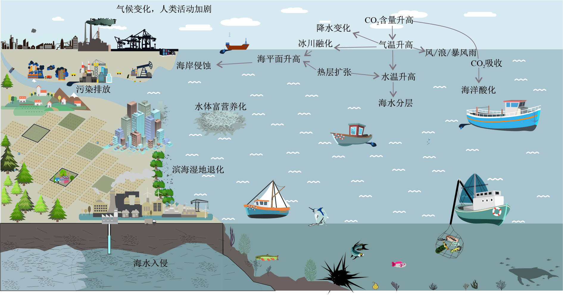
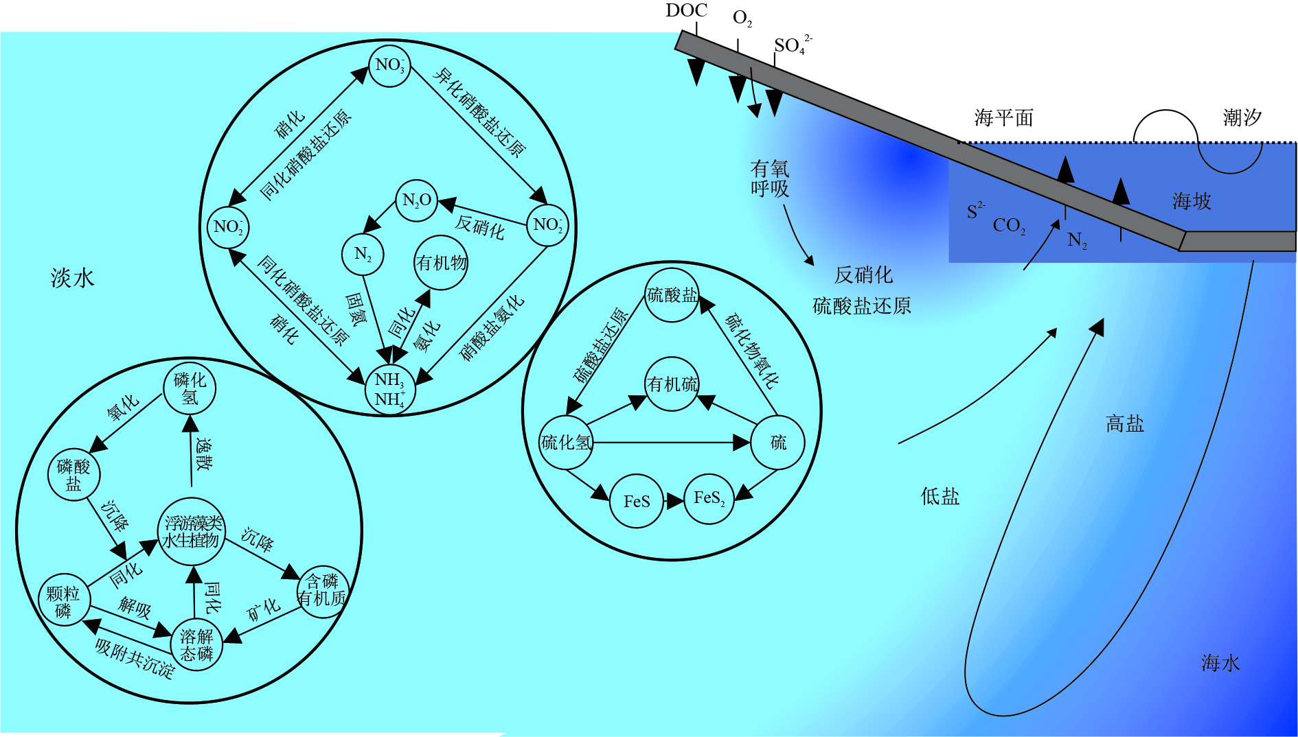
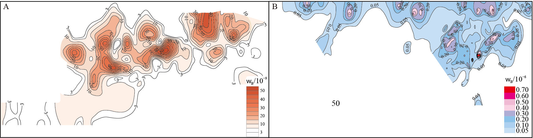
Abstract:
Under the impact of human activities and climate change, coastal zone is one of the most eco-environmentally vulnerable regions of the Earth's surface system with most active exchange for substance, energy and information.With dynamically changing gradients of geochemical parameters such as salinity and dissolved oxygen, the interface processes of coastal zone are manifested in the substance transport and energy exchanges between precipitation, river, ocean, groundwater and sediment.Taking into account of the major eco-environmental problems of climate disasters, coastal erosion, seawater intrusion, coastal wetland degradation, eutrophication, heavy metals, emerging contaminants and microplastic inputs, this paper provided an overview of research advances in four aspects: hydro-biogeochemical cycle, impacts of land-based human activities on coastal environment, the response of coastal environment to climate change, and new methods and technologies for multi-interface observation, and then an outlook on the future developments in studying land-ocean interactions and their eco-environmental effects.
Isotopic approaches to identify groundwater dependent terrestrial vegetation:Progress, challenges, and prospects for future research
Sun Ziyong, Wang Junyou, Ge Mengyan, Qiao Shufeng
2020, 39(1): 11-20. doi: 10.19509/j.cnki.dzkq.2020.0102
Abstract:
As one of the major types of groundwater dependent ecosystems, groundwater dependent terrestrial vegetation (GDTV) has a variety of ecological service functions.Protection of GDTV is an important criterion in sustainable water resources management, particularly when it is being threatened globally by degradation due to the over-exploitation of groundwater and surface water.Identifying GDTV is the first requisite step to managing and protecting it.While GDTV has been identified at large scales using the White method, water balance method, and satellite-based approaches, only stable isotope techniques can provide direct means for identifying GDTV.The stable isotopes approach can be further divided into direct inference approach and mixing model approach.Though only qualitatively identifying GDTV, the direct inference approach is still more prevalent than the mixing model approach.In recent years, with the application of Bayesian mixing models, progress has been made in quantifying the dependency of GDTV on groundwater by using mixing model approach.However, many conceptual and methodological challenges remain.The first one is how representative an individual tree/plant studies are for larger-scale systems, given the spatial and temporal heterogeneity of groundwater use pattern by GDTV, which also makes it difficult to applying our observational results at small-scale to understand catchment-or landscape-scale phenomena.Secondly, it has been found that many plants might use groundwater in an indirect way, which distorts the identifying of GDTV.The third main challenge is how the isotopic fractionation at soil-root interface and the spatial-temporal variation in xylem isotopic signatures within a plant can inform endmember determination.Furthermore, obtaining representative groundwater and soil water samples is also challenging.In the coming years, efforts should be made towards:(1) developing novel methods for in situ, online, and continuous isotopic measurements in xylem water, to help to gather isotope data at higher temporal and spatial resolutions; (2) conducting extensive isotopic labelling experiments with known boundary conditions, to facilitate a more detailed characterization of the flow and fractionation of isotopologues in the groundwater-soil-vegetation system; and (3) developing approaches coupling physically based ecohydrological models and isotopic observation, to provide root water uptake profiles with high spatial resolution andlower uncertainty.
Hydrochemical characteristics of groundwater and analysis of groundwater flow systems in Jianghan Plain
Liang Xing, Zhang Jingwei, Lan Kun, Shen Shuai, Ma Teng
2020, 39(1): 21-33. doi: 10.19509/j.cnki.dzkq.2020.0103
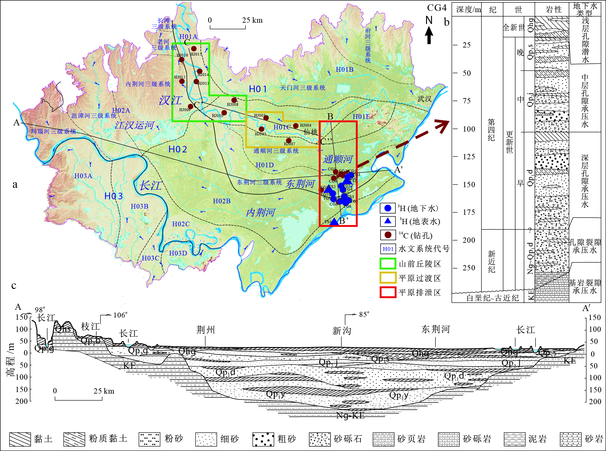
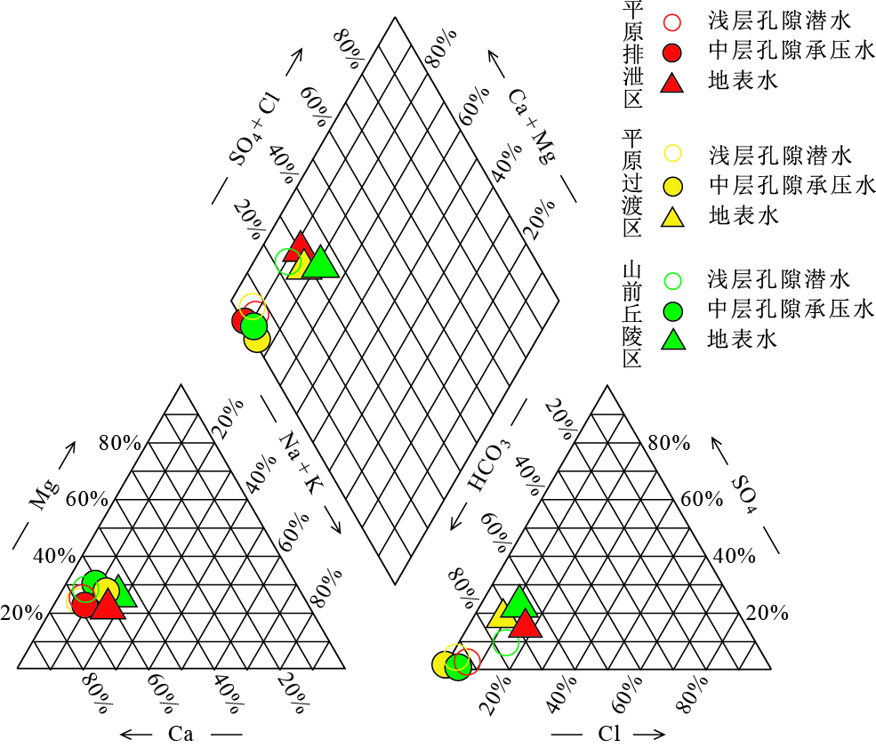
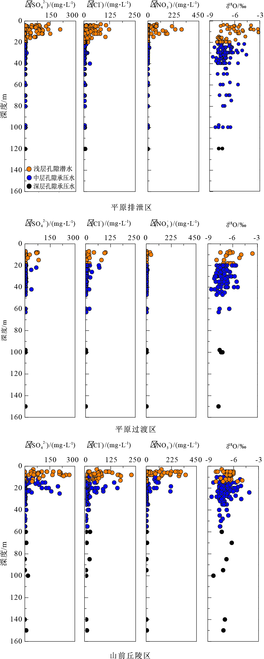
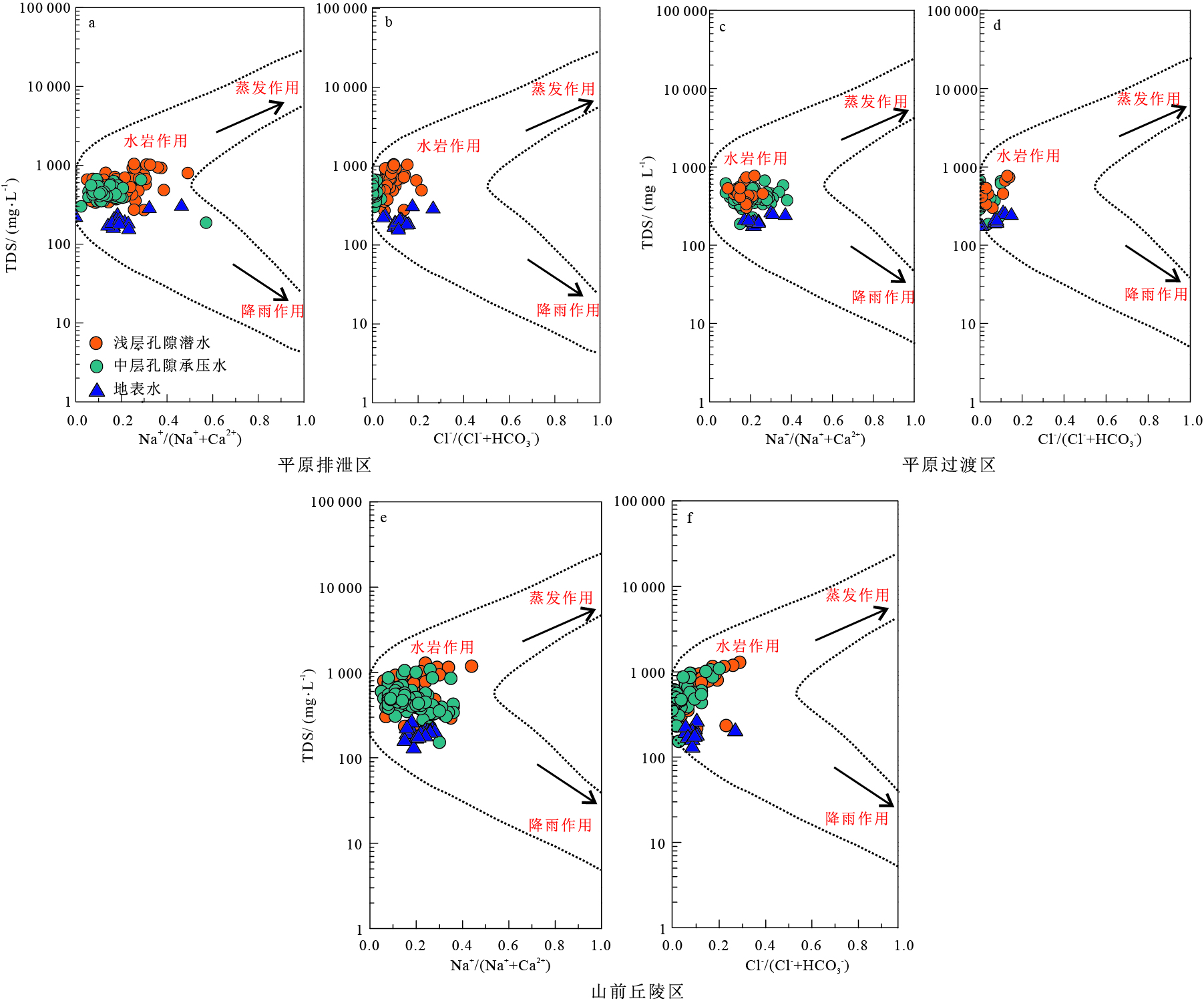
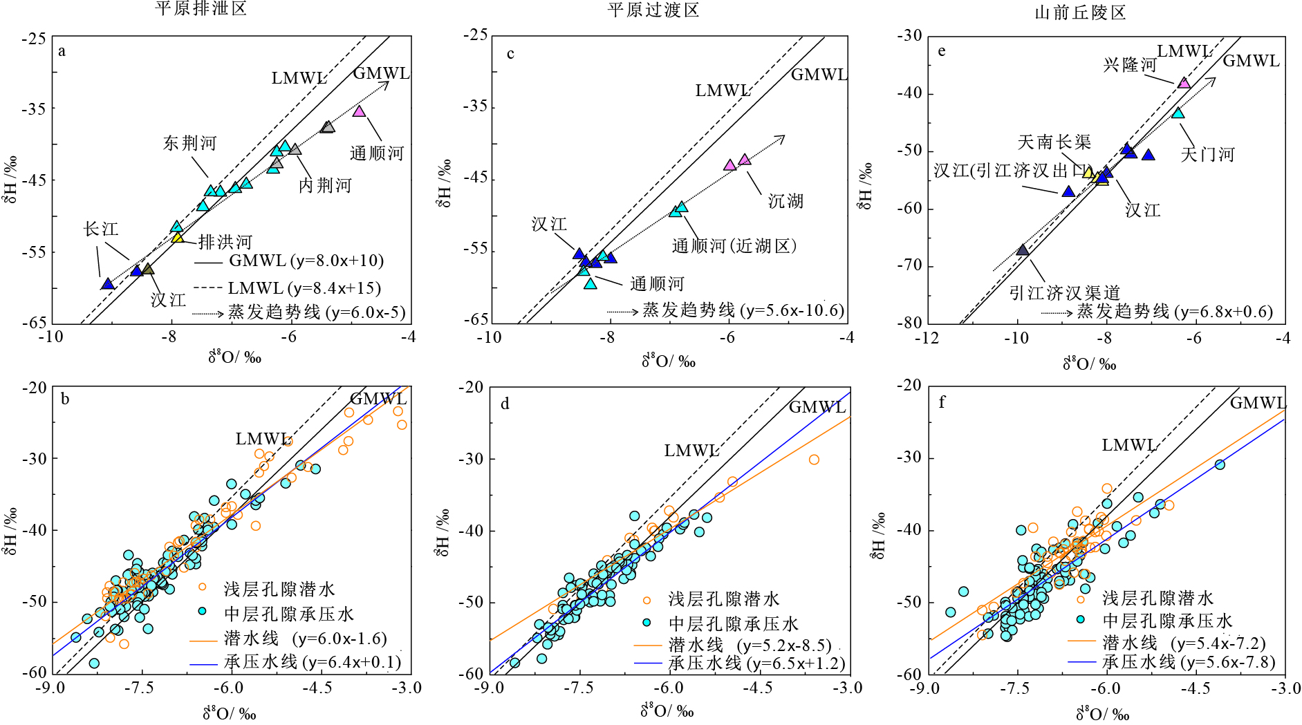
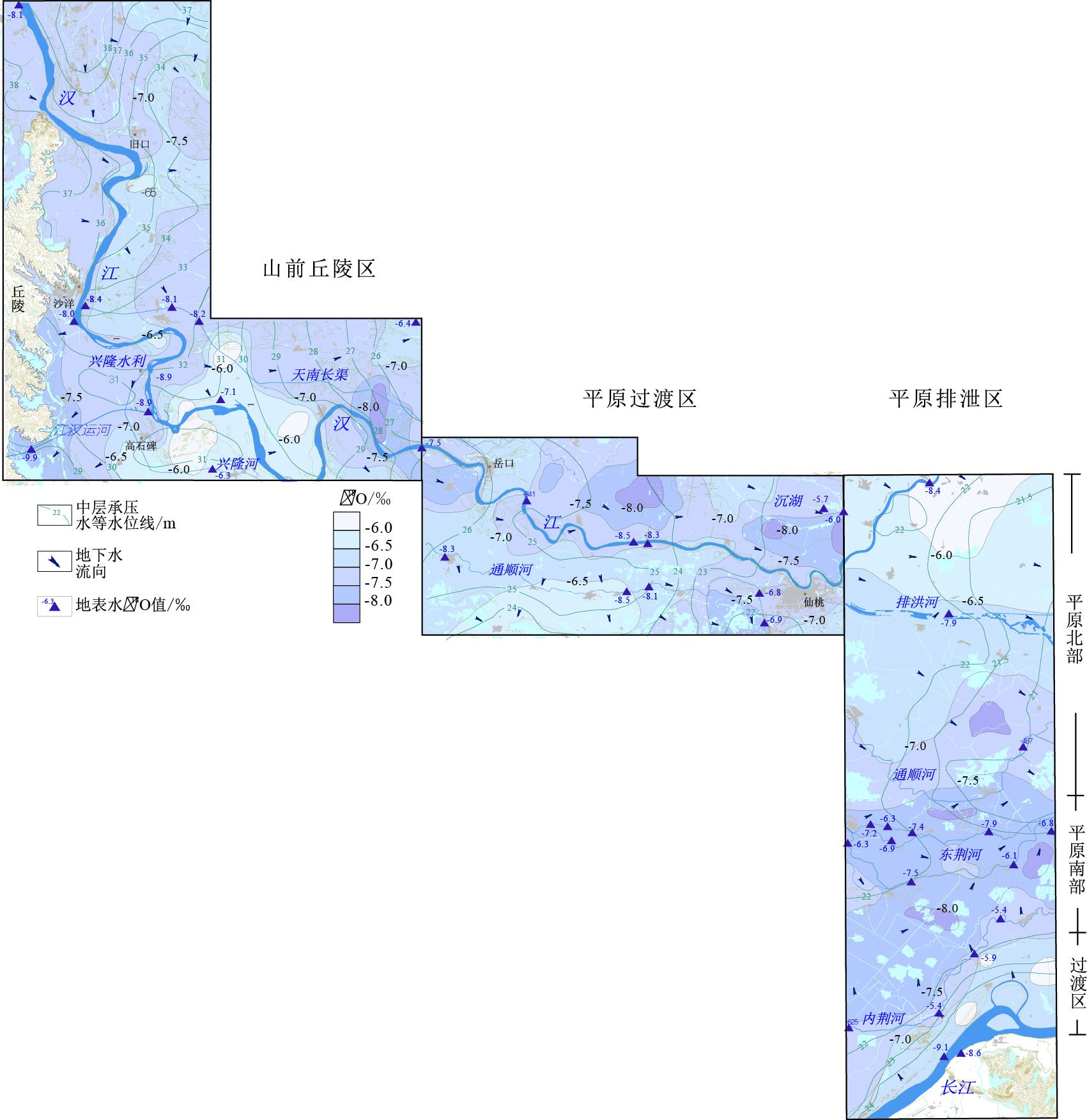
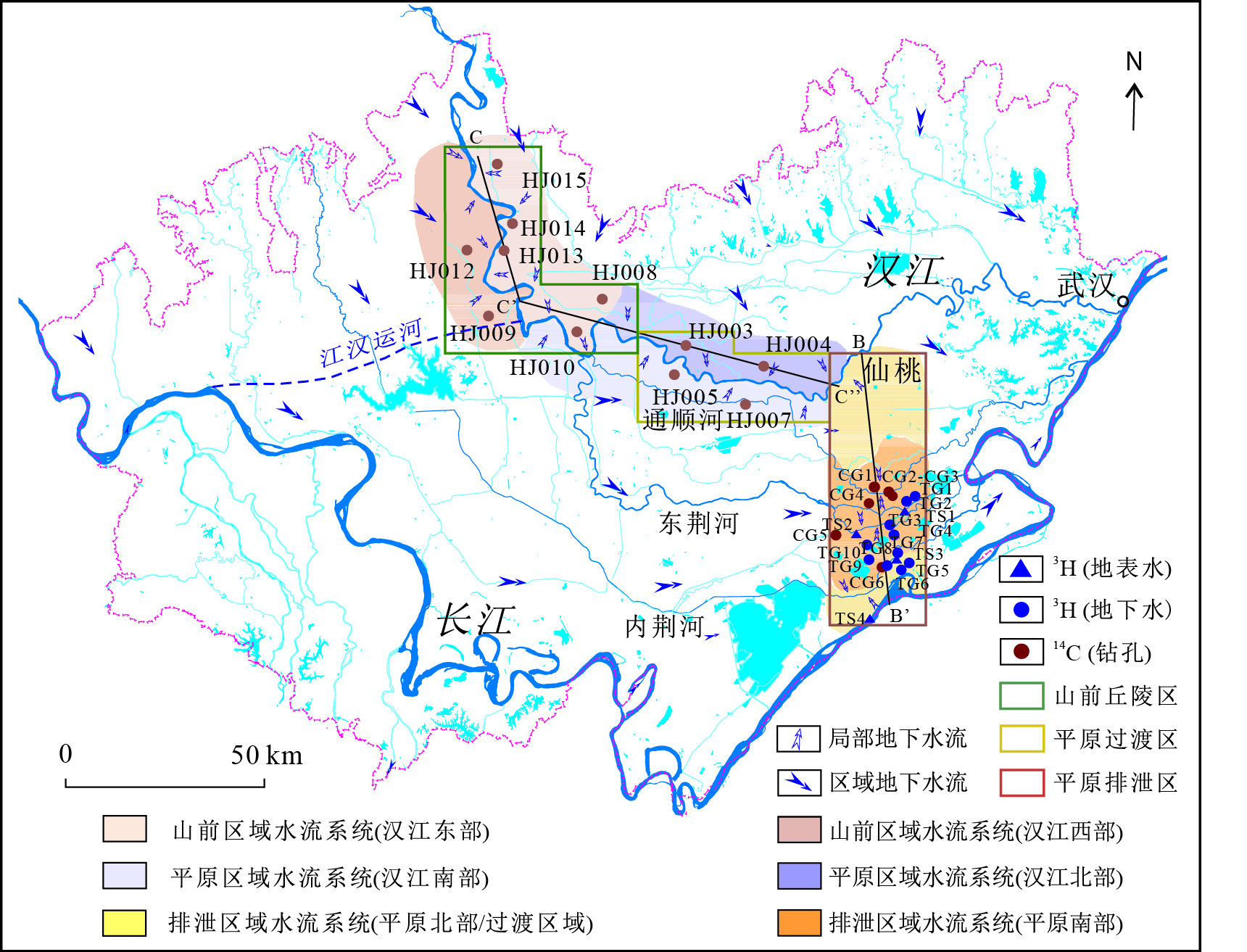
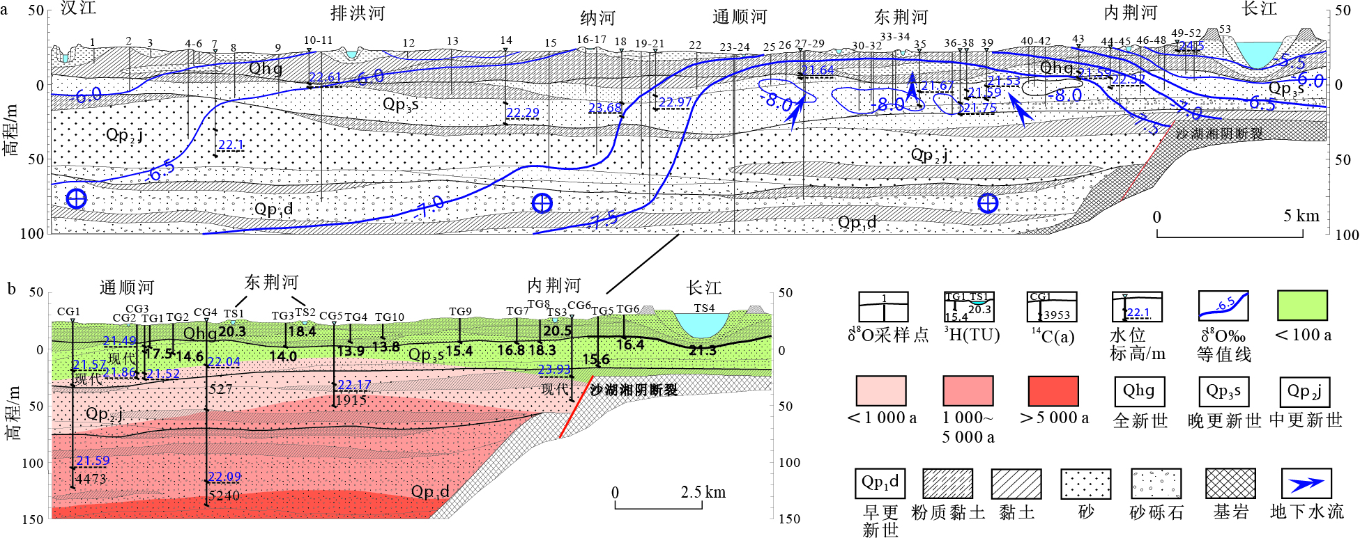
Abstract:
Based on increasingly serious groundwater quality problems in Jianghan Plain, the investigation of groundwater flow systems (GFSs) is vital for the sustainable management and protection of water resources. Hydrogeological conditions, hydrodynamic field and hydrogeochemistry were used to gain insight into the recharge process, water-rock interactions, and groundwater residence time in the typical area of Jianghan Plain. Because of carbonate mineral weathering, groundwater is predominantly of the HCO3-Ca·(Mg) type. The decrease of typical ions and the depletion of isotopic distributions with depth increasing indicate that the GFSs were divided into local and regional GFSs with a depth limitation of approximately 10~20 m. The complex and independent local GFSs exhibit a pattern in which groundwater discharged into surface waters during the nonflood season. Groundwater age of local GFSs is modern according to the 3H concentrations, indicating the hydrodynamic circulation is active. Furthermore, controlled by topography, the regional GFSs flow from west or northwest to east or southeast, eventually discharging into the Yangtze River and the Han River. The evident zonations of δ18O distribution in regional GFSs are dominated by the altitude effect of recharge areas, indicating different recharge sources and flow paths. The piedmont hilly area is basically modern water. Deep into the hinterland of the plain to the discharge area of the Han River and Yangtze River, groundwater age of regional GFSs varied from hundreds of years to 6 000 years estimated by 14C isotope data, elucidating that the hydrodynamic circulation is slow to relatively stagnant. The existence of regional GFSs driven by an upward hydraulic gradient in the low-lying discharge area of Jianghan Plain, can provide a theoretical basis for researching the distribution and aggregation of primary inferior groundwater.
Source identification and health risk assessment of groundwater pollution in typical sewage pits and ponds
Xie Xianjun, Liu Hongxing, Gao Shuang, Su Chunli
2020, 39(1): 34-42. doi: 10.19509/j.cnki.dzkq.2020.0104
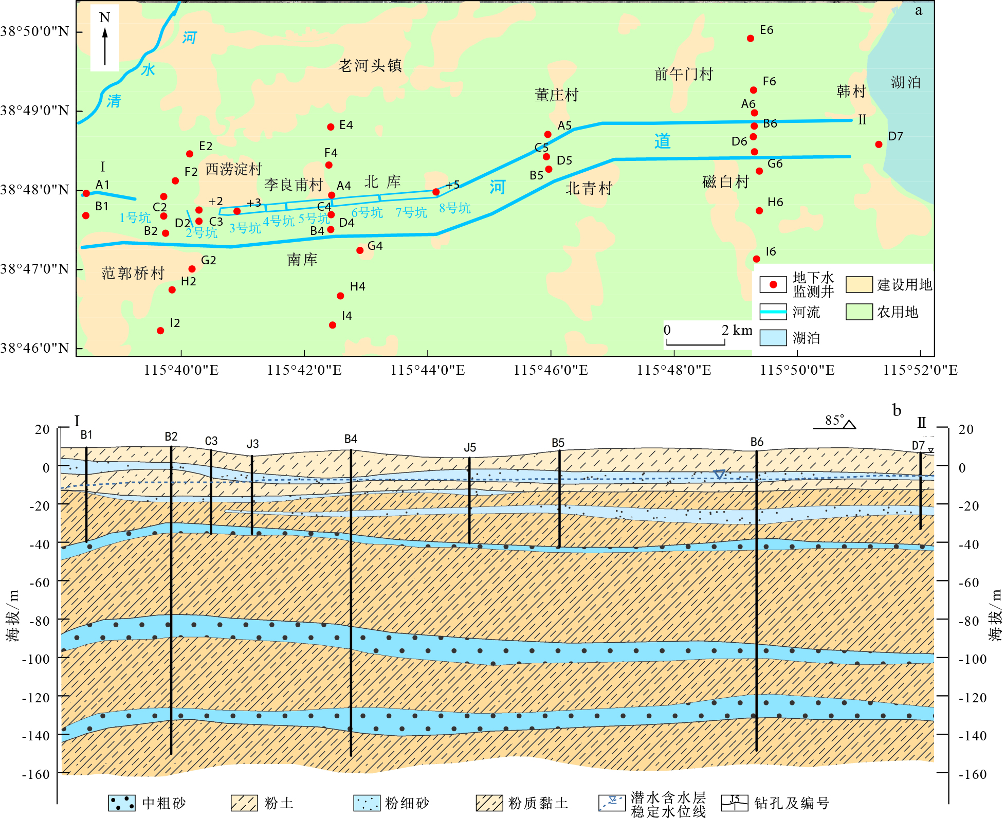
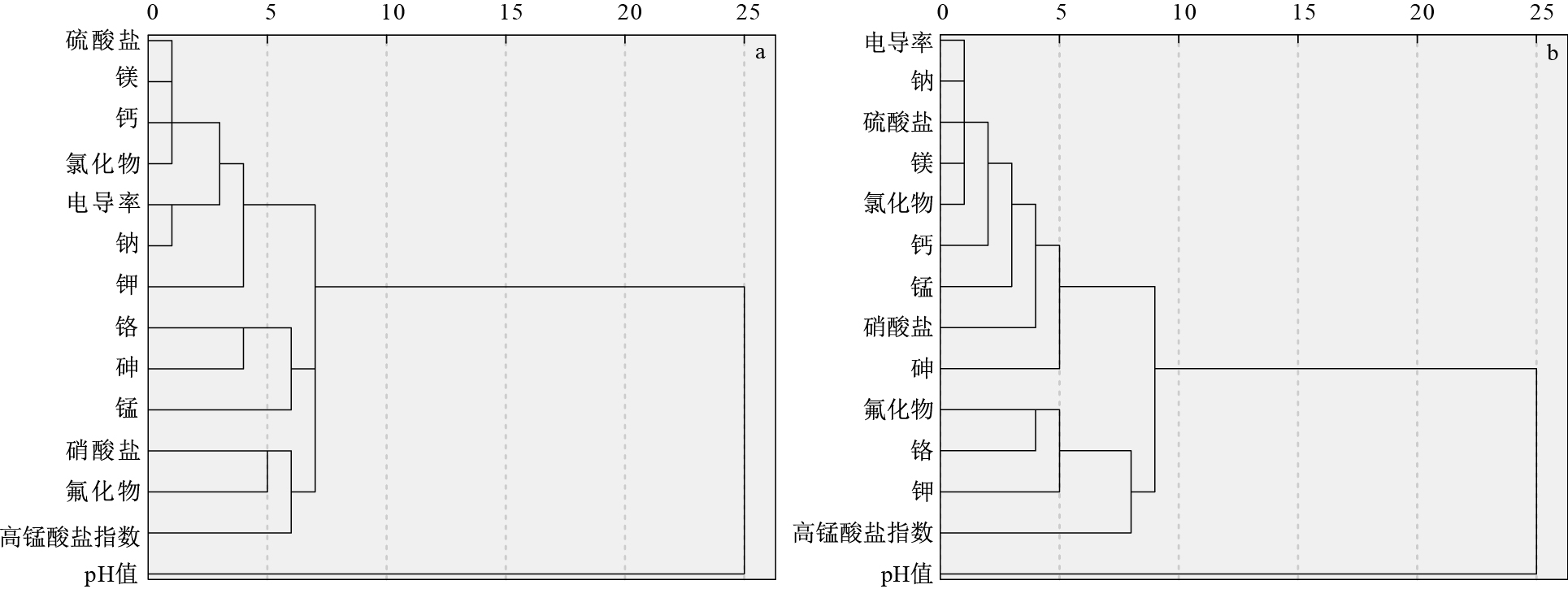
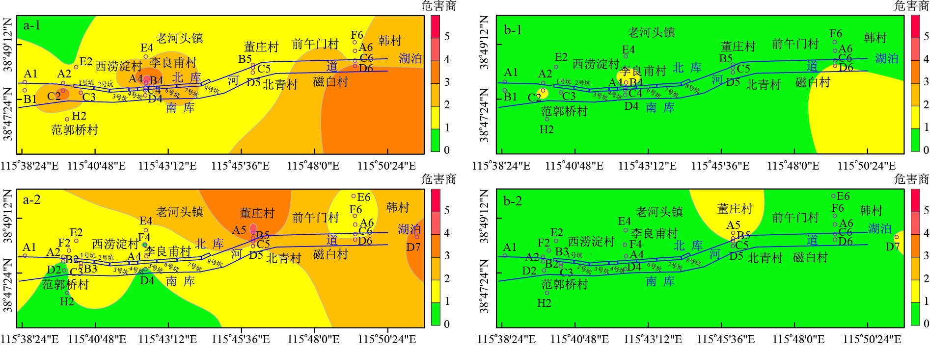
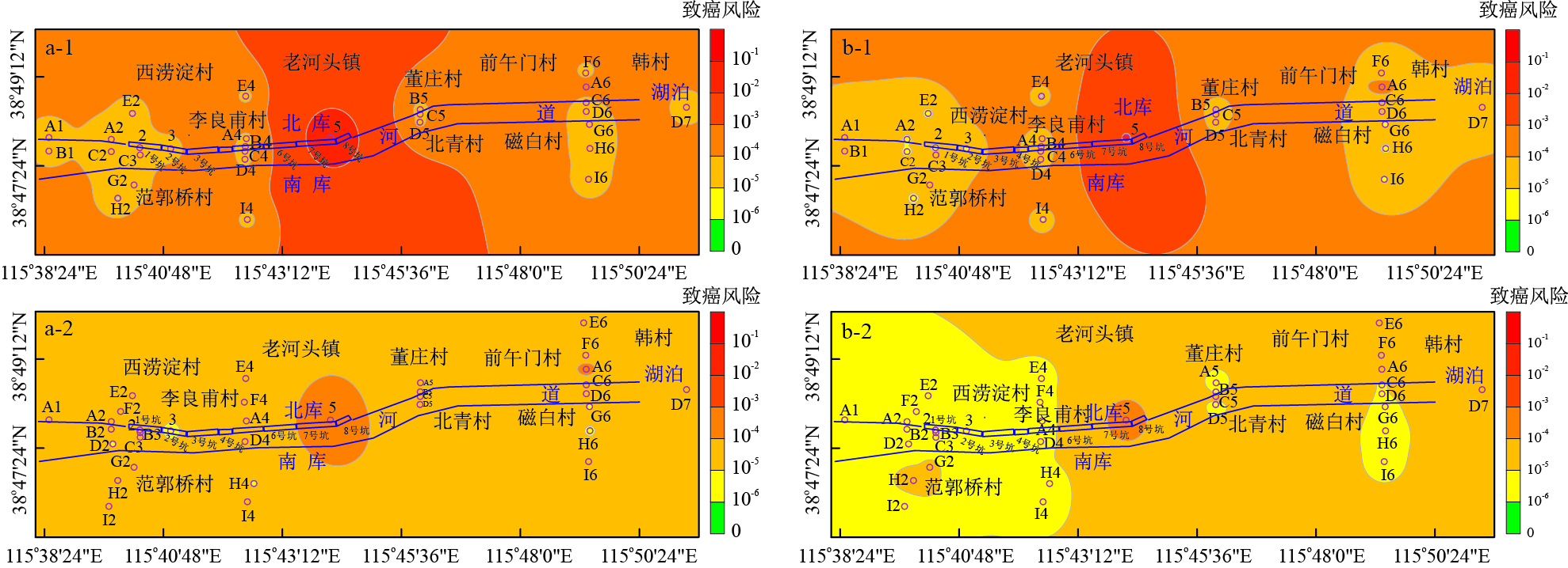
Abstract:
In order to study the groundwater pollution in typical sewage pits and ponds and its potential risk to human health, based on the groundwater quality monitoring data, the source of groundwater pollution in the area was identified, and the water environment health risk assessment model was used to systematically assess the health risk of groundwater pollution in the area. The results of pollution source identification show that groundwater pollution in the first and second aquifers is serious, and the main pollution sources are industrial waste water and industrial waste residue stacked in the area. The results of health risk assessment show that the total carcinogenic risk of arsenic in the first aquifer near NO.8 pit in the area and the total carcinogenic risk of 1, 2-dichloroethane in the second aquifer on the south side of the north reservoir are 10-2 and 10-3, far higher than the acceptable risk level of 10-6 and other monitoring wells around. The overall relationship between the average carcinogenic risk of pollutants in different aquifers is as follows: the first aquifer: arsenic > 1, 2-dichloroethane; the second aquifer: 1, 2-dichloroethane > arsenic > 1, 1, 2-trichloroethane > carbon tetrachloride. Among the various exposure routes, drinking groundwater is the main exposure route for such pollutants as fluorine, arsenic, 1, 2-dichloroethane, 1, 1, 2-trichloroethane and carbon tetrachloride. The relationship between the average carcinogenic risk of four potential exposure routes of volatile organic pollutants such as 1, 2-dichloroethane is as follows: drinking groundwater > skin contact with ground water>inhaling gaseous pollutants from groundwater in outdoor air > inhaling gaseous pollutants from groundwater in indoor air. Compared with sensitive landuse, non-sensitive landuse has lower cancer risk and hazard quotient since the exposure hazards in childhood is not considered.
Numerical study on evolution of groundwater hydrodynamics and land subsidence under the process of metropolitan urbanization in Beijing Plain, China
Cheng Jianmei, Liu Can, Li Minmin, Xue Qi, Gong Huili, Liang Tengfei
2020, 39(1): 43-52. doi: 10.19509/j.cnki.dzkq.2020.0105
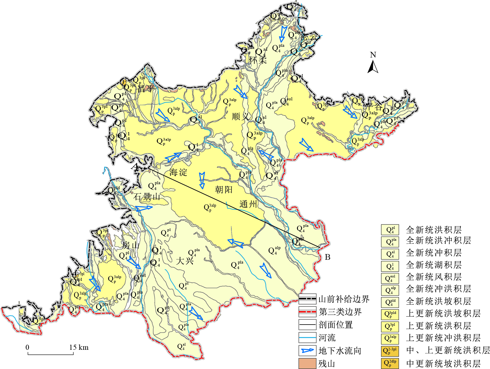
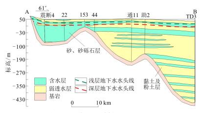
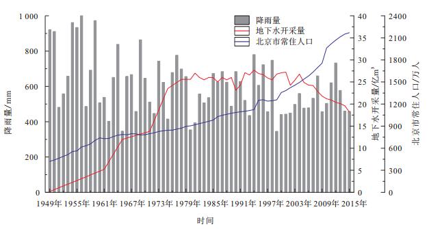
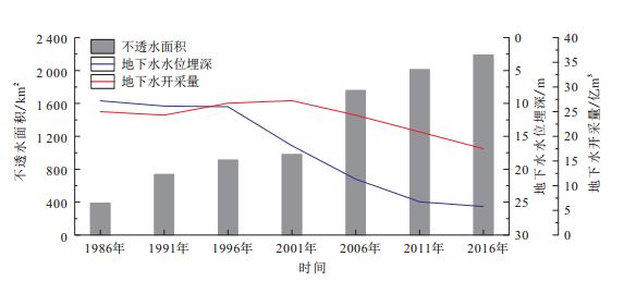
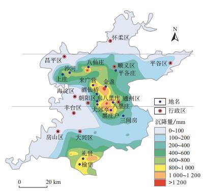
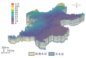
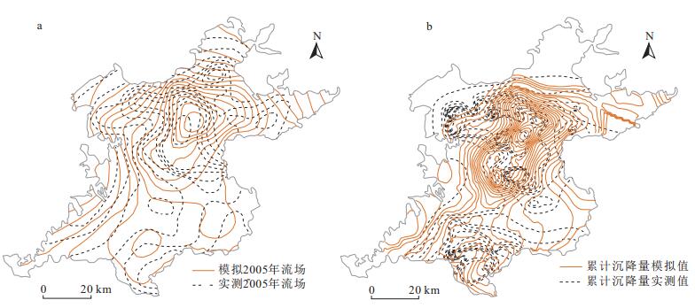
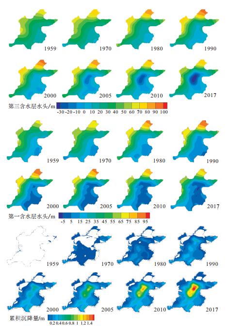
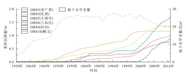
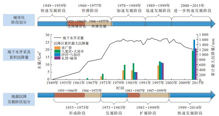
Abstract:
Ground subsidence in Beijing has a history of more than 60 years, which has close relationship with the rapid expansion of Beijing City in the past half a century. In this paper, based on the groundwater flow system of the entire Beijing Plain, a large amount of data of urban development scale, population, and water dynamics over a multi-year time series (1950s-2015s) has been combed, and the impervious covers of the Beijing Plain in different years are interpreted so as to analyzes the changes of rainfall infiltrations into groundwater systems by using remote sensing technology.After generalized a three-dimensional aquifer-aquitard structural system in the entire plain, a regional model coupling multi- groundwater flow with land subsidence model with PMWIN software, which is identified and verified by converging long-term water level and subsidence observation data. Long-term evolution simulation of groundwater hydrodynamics and land subsidence have been performed to study the evolution of the water cycle and the response characteristics of land subsidence in a multi-layer aquifer system in the Beijing Plain under rapid urbanization.The results show that the long-term evolution simulation coupling groundwater flow and land subsidence basically reproduces the process of formation and development of land subsidence.The history of groundwater abstraction in Beijing City is consistent with the history of land subsidence development. Moreover, the land subsidence developments in different subsidence areas are mainly controlled by groundwater abstraction and metropolitan urban development.
Water vapor transport mechanism in unsaturated zone of rock slope and its ecological significance
Zhou Jianwei, Su Danhui, Yuan Lei, Wen Bing, Feng Haibo, Zheng Xiaoming, Yin Zuocong, Zhang Anpeng
2020, 39(1): 53-59, 66. doi: 10.19509/j.cnki.dzkq.2020.0106
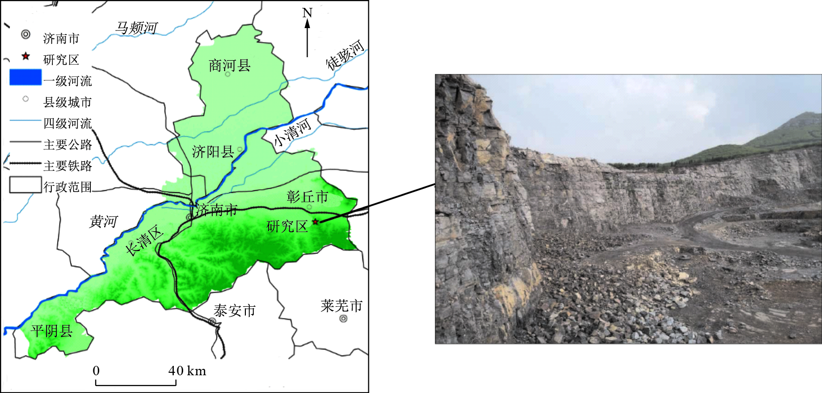
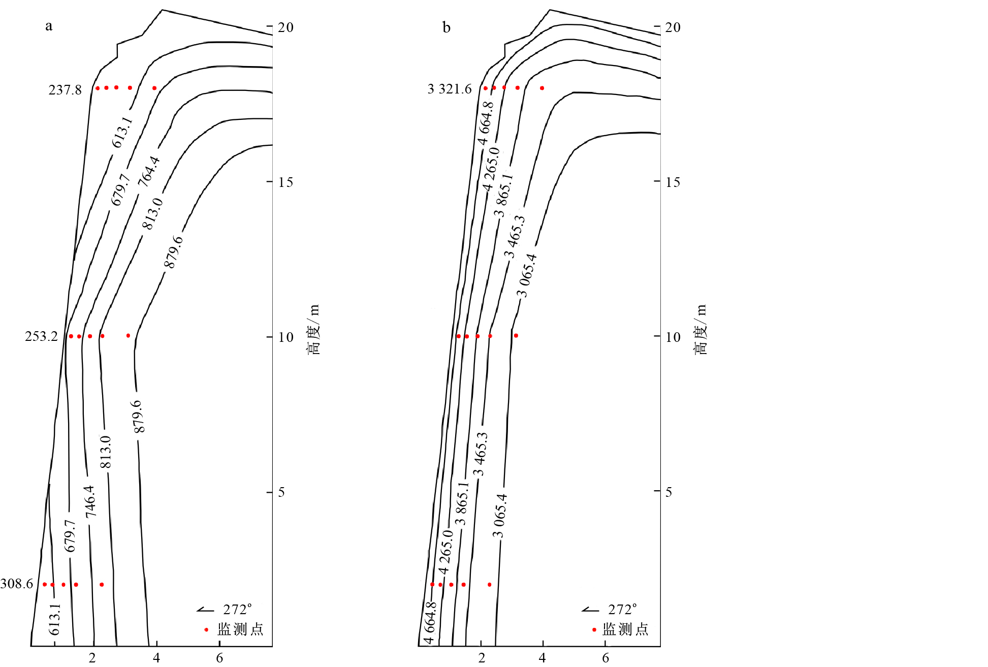
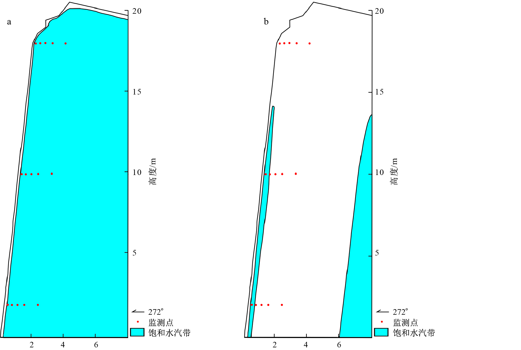
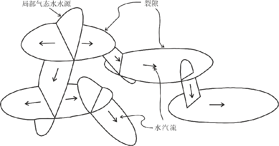
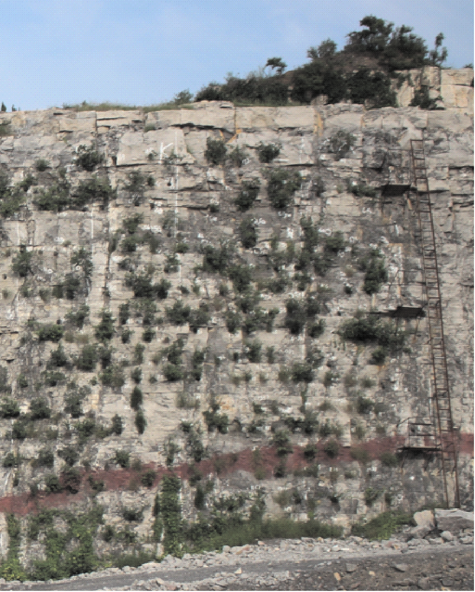
Abstract:
Water in unsaturated zone of rock slope has important ecological significance for plant growth.At present, there are few systematic studies on water vapor transport in unsaturated zone of rock slope.Most of studies focus on the interface between atmosphere and rock mass and the qualitative level of whether condensate water can be generated, while the unsaturated zone of rock slope is not studied as a whole system.In order to elucidate the water vapor transport mechanism in unsaturated zone of rock slope and its relationship with plant growth, this paper carries out temperature and humidity monitoring test of the slope by means of thermodynamics and system science theory, and studies the water vapor transport mechanism in detail.It is found that the driving force of water vapor migration in the unsaturated zone of rock slope is the partial pressure gradient of water vapor.In winter, water vapor migrates from deep to shallow part of the slope; in summer, water vapor migrates from atmosphere to deep part of the slope.The unsaturated zone of rock slope has water vapor saturation zone, which is larger in summer and smaller in winter.At the same time, through monitoring and analyzing the survival rate of compound green plants in rock slope, the mechanism of water vapor circulation in unsaturated zone of rock slope and its ecological significance were discussed.This paper is of great theoretical and practical significance for studying hydrology of rock mass unsaturated zone, exploring the source of plant water, guiding the rehabilitation of rock slope and even arid and semi-arid zone.
Semi-analytical solution for radial solute transport model with skin effect
Wen Zhang, Li Xu
2020, 39(1): 60-66. doi: 10.19509/j.cnki.dzkq.2020.0107
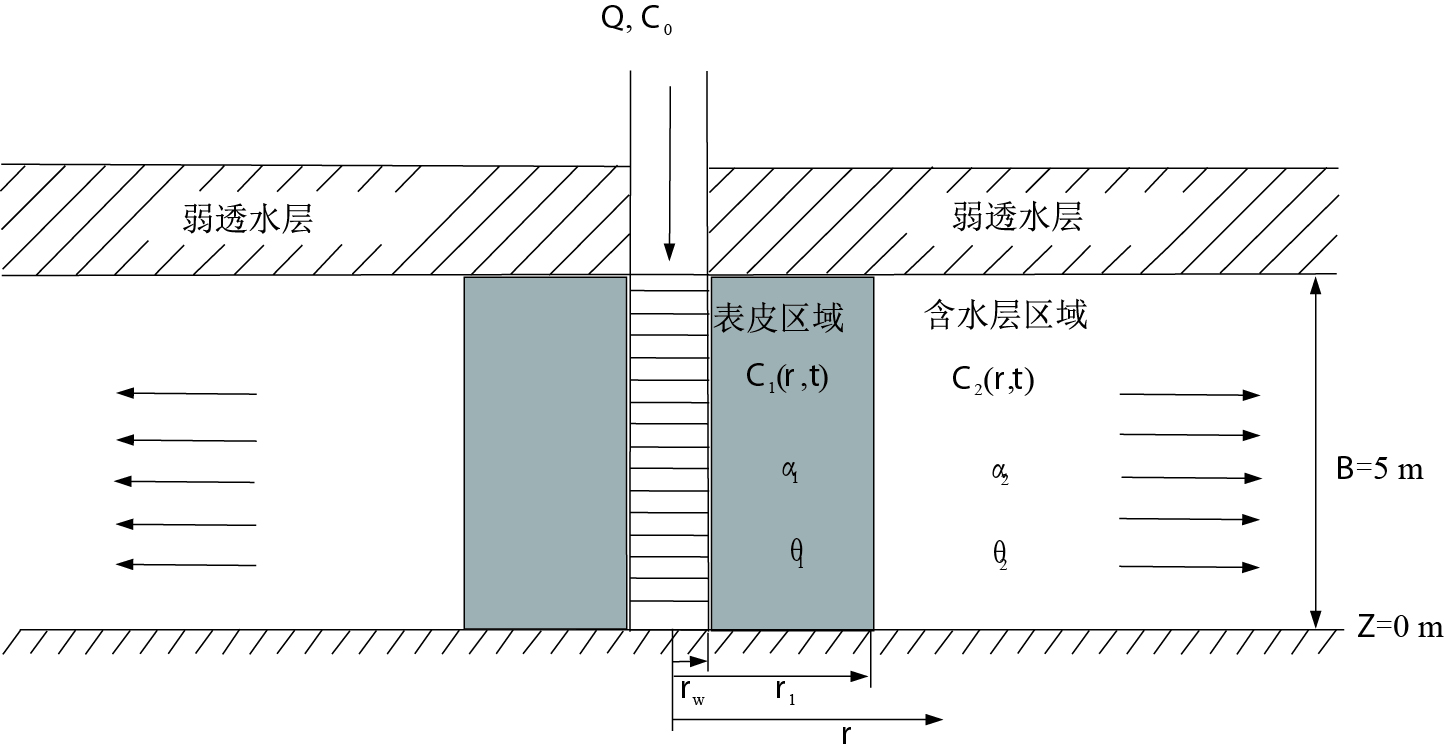
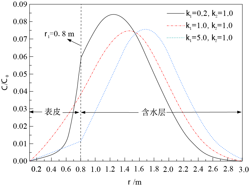
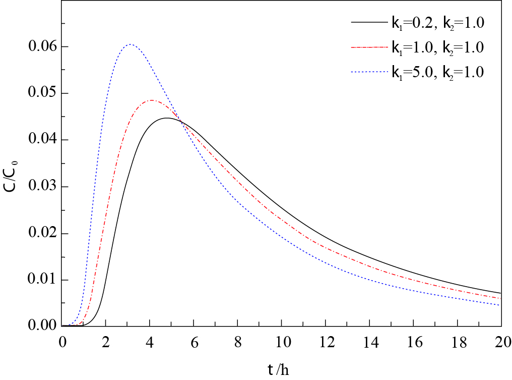
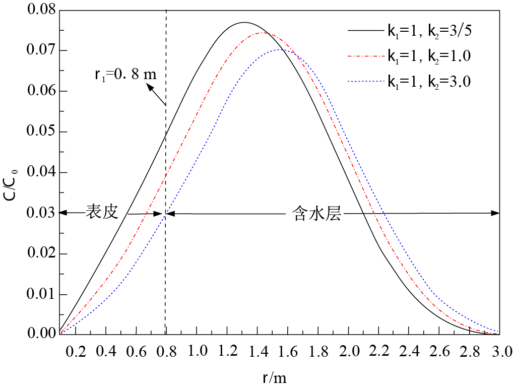
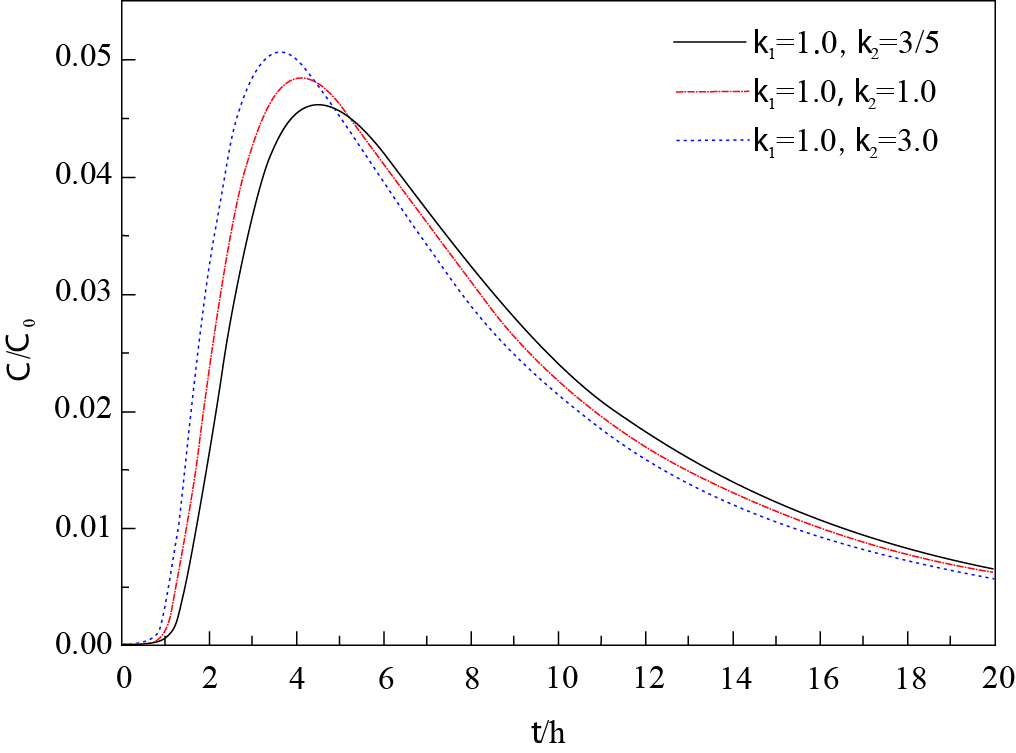
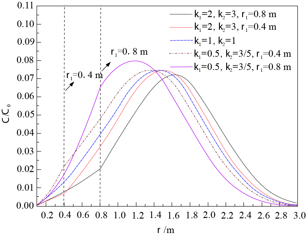
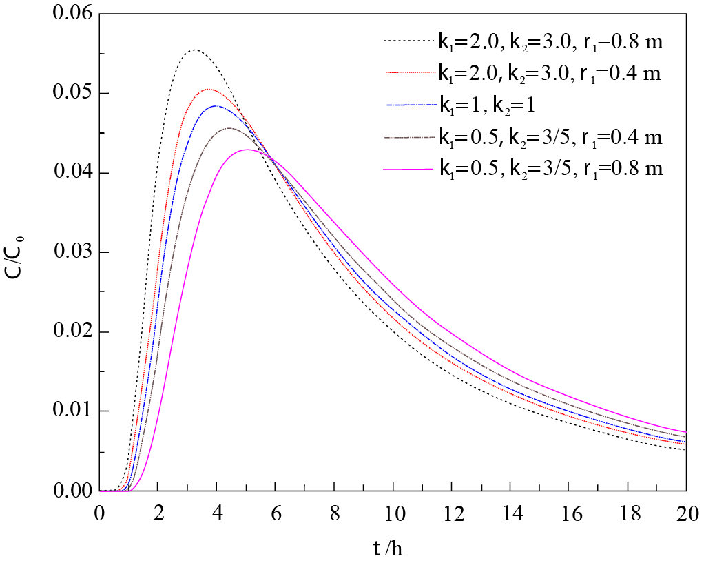
Abstract:
Radial tracer test is one of the most effective ways to estimate aquifer transport parameters.However, traditional tracer tests usually neglect skin effect near a pumping well, due to extensive well development resulting in anomalous hydrogeological properties.A semi-analytical model for a confined aquifer was developed to analyze the effects of skin of hydrogeological properties on breakthrough curves.The Laplace transform and numerical inverse Laplace methods were used to solve the model.The results indicate that a larger dispersivity in the skin zone results in higher values of breakthrough curves (BTCs) at the early injection stage, and higher peak values of BTCs; however, larger effective porosity in the skin zone results in lower values of the BTCs at the early injection stage but generates higher values at the late stage; besides, an abrupt change for the spatial concentration distribution was observed at the interface of the skin and aquifer formation zones due to the change of dispersivity in the skin zone.The general conclusion is that the possible impacts of skin on radial solute transport are significant and should be taken into consideration in tracer-injection tests.
Advance and prospect of formation mechanism for reservoir landslides
Li Changdong, Long Jingjing, Jiang Xihui, Fu Zhiyong
2020, 39(1): 67-77. doi: 10.19509/j.cnki.dzkq.2020.0108
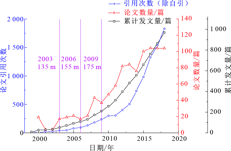
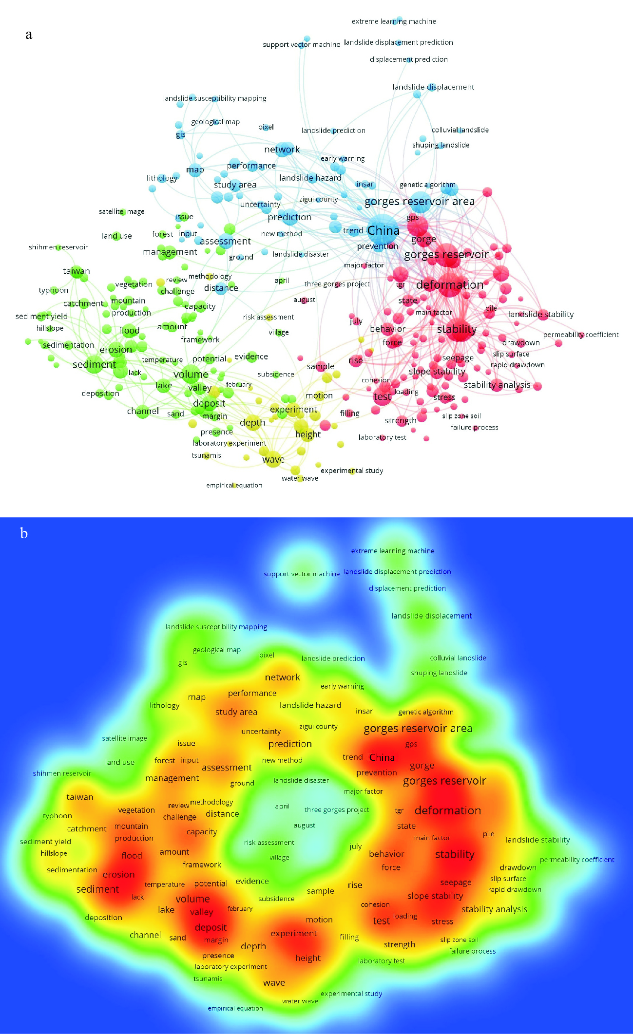
Abstract:
Reservoir landslide is one of the main type geohazards in the reservoir area.It is of great theoretical significance and engineering application value to carry out formation mechanism research of reservoir landslides.To figure out the research trends, 969 papers about reservoir landslides published from 1999 to 2018 in Web of Science database were searched and conducted a statistically analysis with the bibliometric tool VOSviewer.The results show that landslides stability and deformation will be the heated issue in the Three Gorges Reservoir Area in future related reservoir landslides research.In this paper, the main achievements and progress of reservoir landslide mechanism research at home and abroad are summarized in terms of the macroscopic mechanical action mode of reservoir water on landslide, the seepage stress coupling mechanism of rock-soil mass under the action of reservoir water and the deterioration process of rock-soil mass under the action of reservoir water.Analyzing the existing research results, there are some problems in the fine modeling of reservoir landslide, the multi-field acquisition of characteristic parameters of rock and soil, the evaluation of long-term evolution of bank slopes, etc.To deal with the problem of previous literature reviews and realizing long-term stability of reservoir landslides, the research system of reservoir landslides should be founded that multi-field monitoring is regarded as the key manner and the strategy of combining multidisciplinary intersection with artificial intelligence and big data analysis is also considered as the crucial technology.Considered the complexity of geological environment of reservoir landslides, the future research directions of reservoir landslides are proposed to perform related research on reservoir landslides.Breakthrough achievements will be made if researchers focus on that fine geological model, reservoir landslide multi-field relevance monitoring technology, the multi-scale process of the reservoir landslide geological structure evolution, the determination of reservoir landslide warning threshold with monitoring data of big data analysis and the construction of reservoir landslide in situ testing ground platform.
Energetics parameter estimation of jointed rock mass based on Hoek-Brown failure criterion
Chai Bo, Tao Yangyang, Du Juan, Tai Daping, Wang Yu
2020, 39(1): 78-85. doi: 10.19509/j.cnki.dzkq.2020.0109
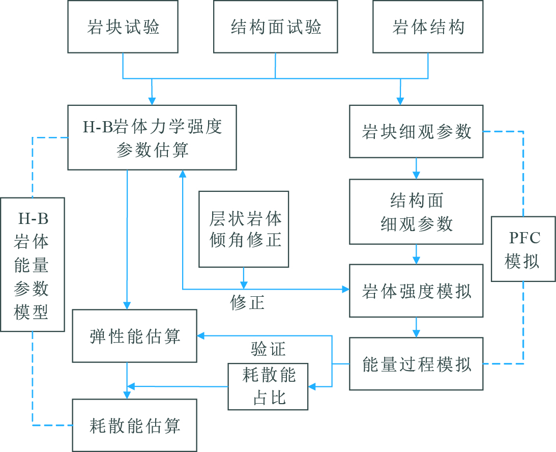
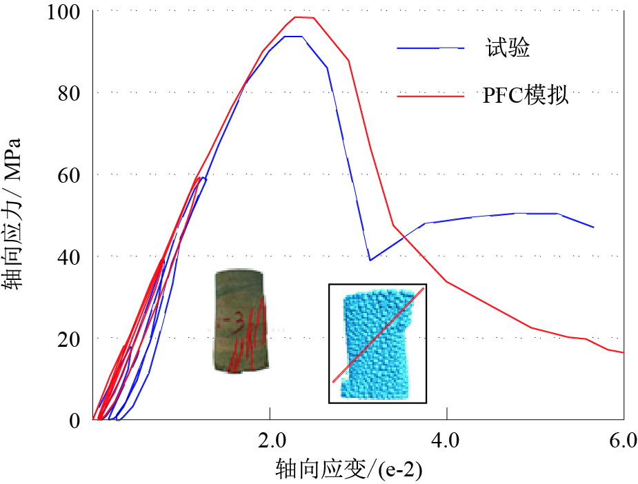
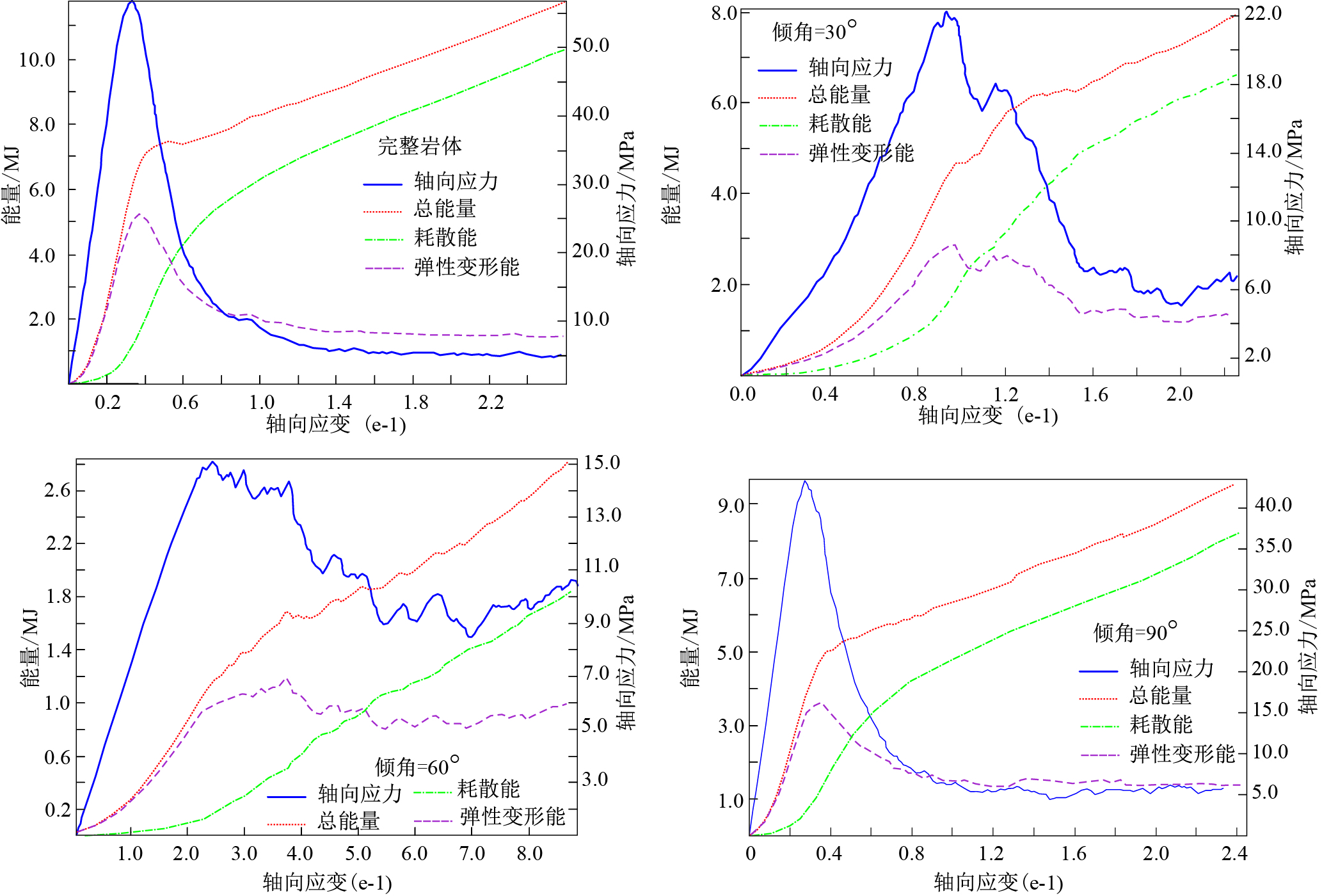
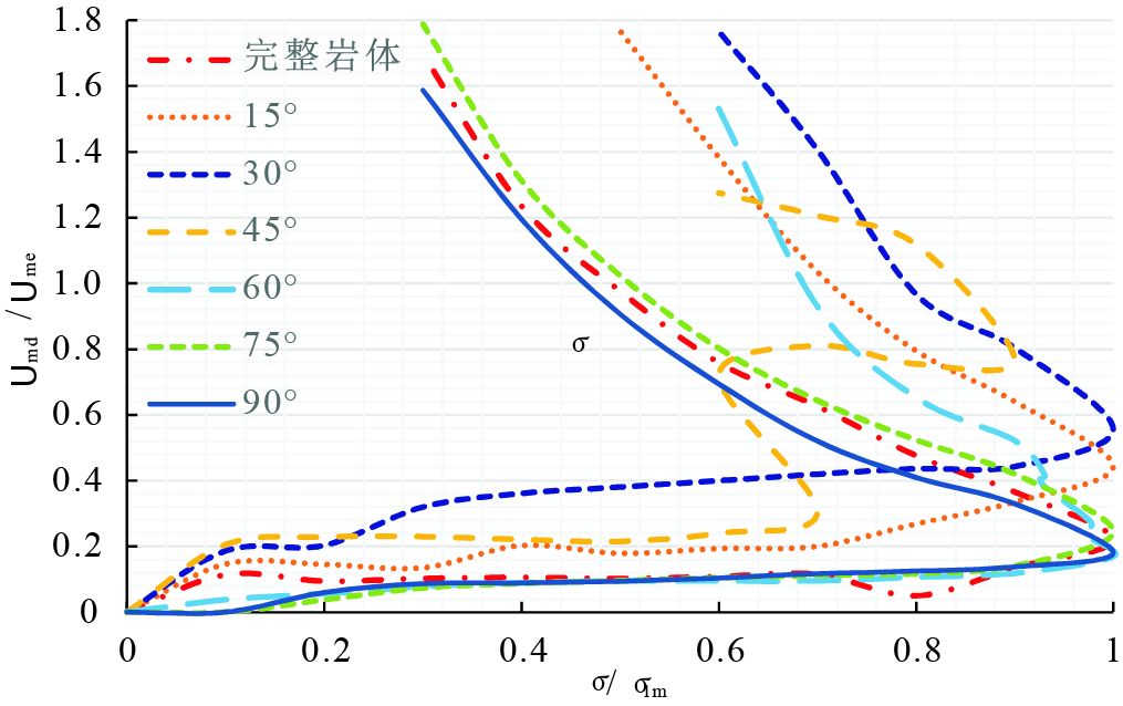
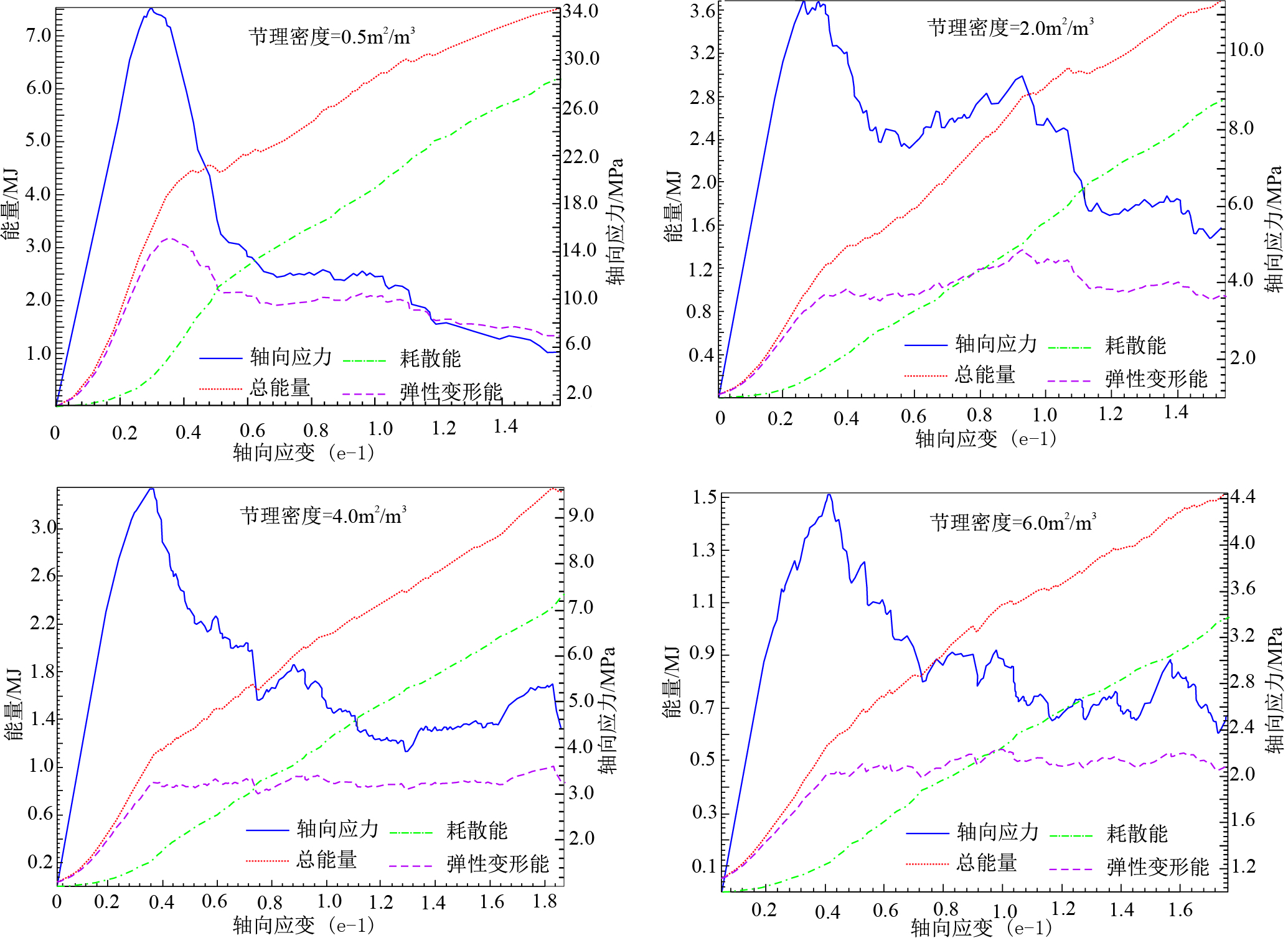
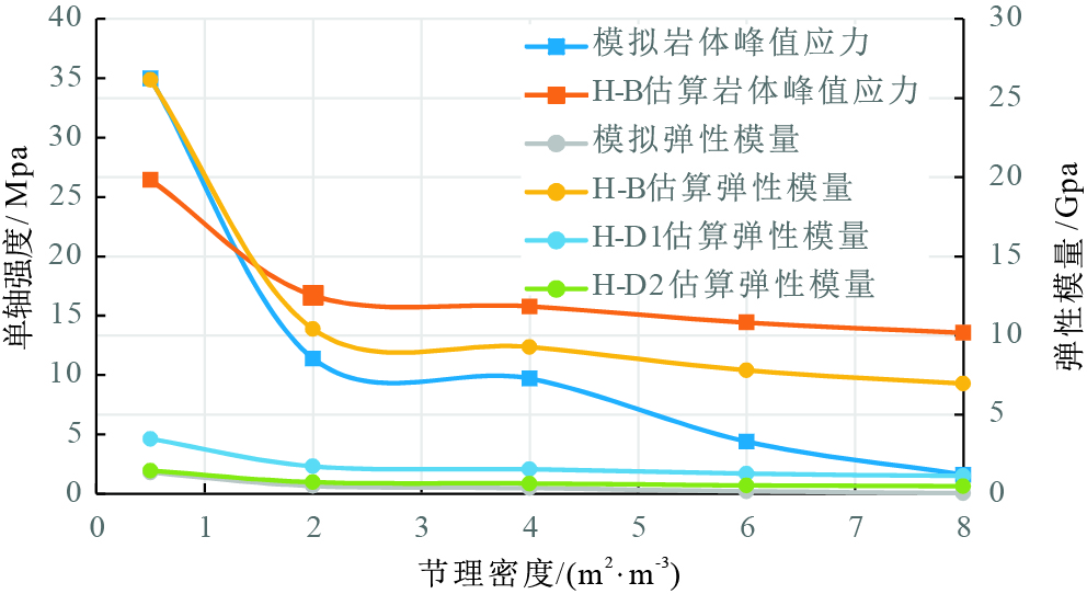
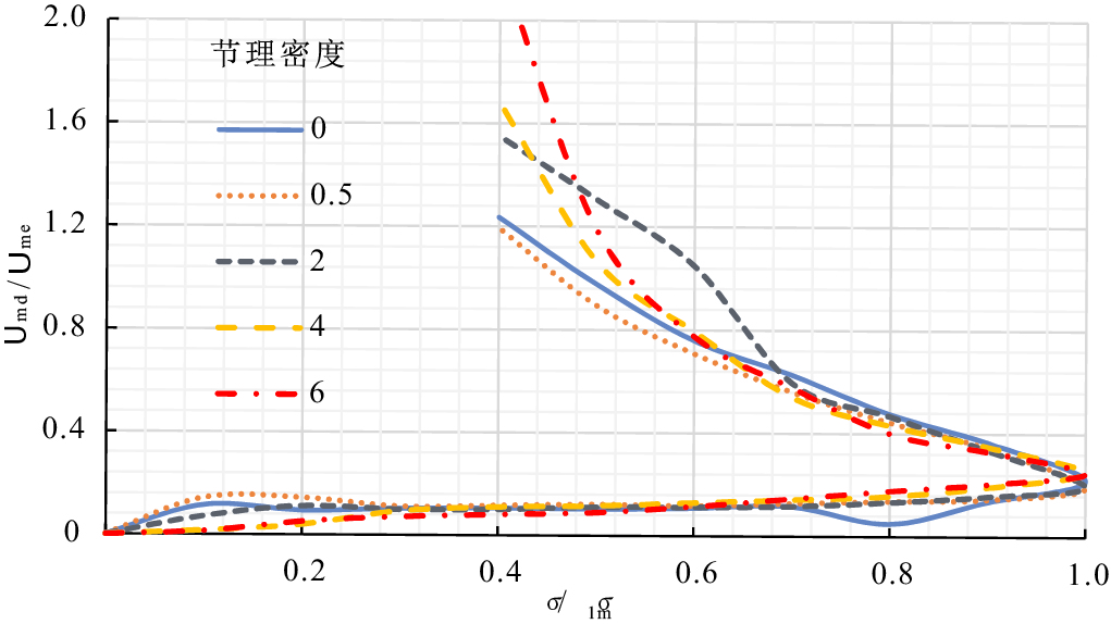
Abstract:
The deformation and failure of rocks are a process of energy dissipation and release. For the jointed rock masses, the estimation of energetics parameters during loading procedures is a challenge because of their complex structures and difficulties of laboratory tests. The paper proposed a methodology for the energetics parameter estimation of jointed rock masses in critical state based on the Hoek-Brown failure criterion and rock energy theory. For the rock mass with continuous joints (or layers), the orientation effect of continuous joints was reflected by the revised uniaxial compressive strength of rock piece. The PFC3Dnumerical simulation software was used to simulate the triaxial compressive process with small size models of rock pieces (Φ50 mm×100 mm) and big size models of rock masses (Φ2 m×2 m). The mesoscopic parameters of rock numerical model were calibrated by the result of triaxial compression test and applied for the numerical simulation of jointed rock mass. The estimated energetics parameters derived from Hoek-Brown failure criterion were proved to be accurate by the validation with simulated stress strain curves and energy curves.
Design and application of multifunctional physical model test device for movement and accumulation process of rapid long-runout landslide
Ge Yunfeng, Li Xinjie, Du Bin, Qiu Yashi, Zhao Binbin, Zheng Hai, Sun Hao
2020, 39(1): 86-94. doi: 10.19509/j.cnki.dzkq.2020.0110
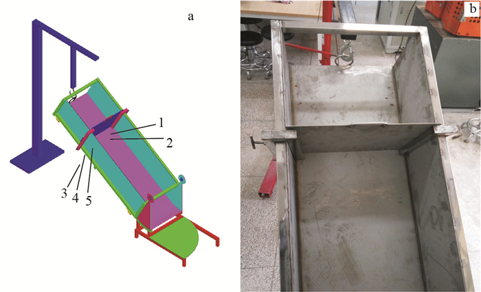
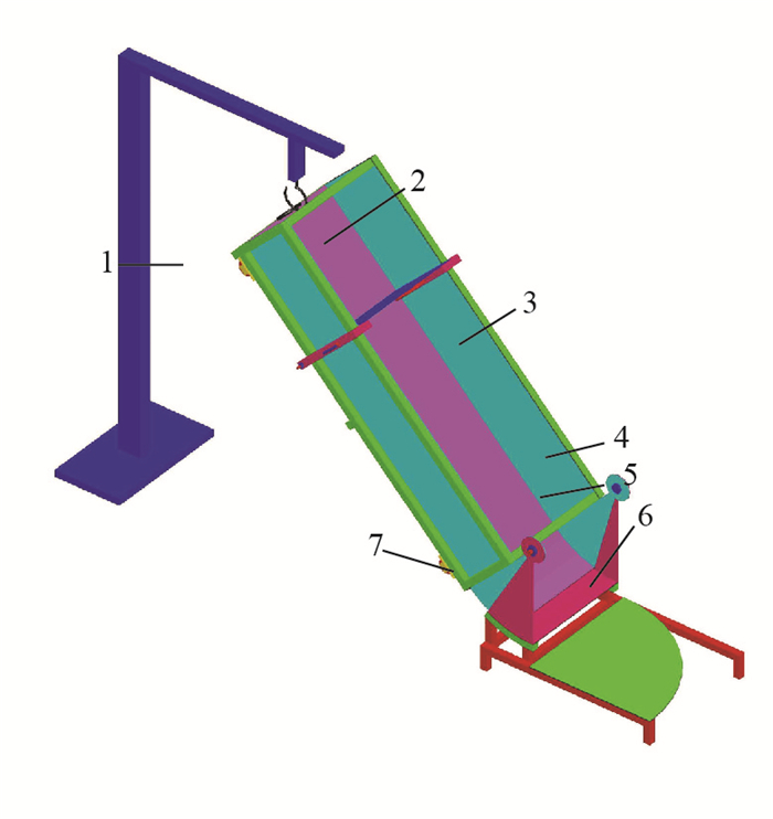
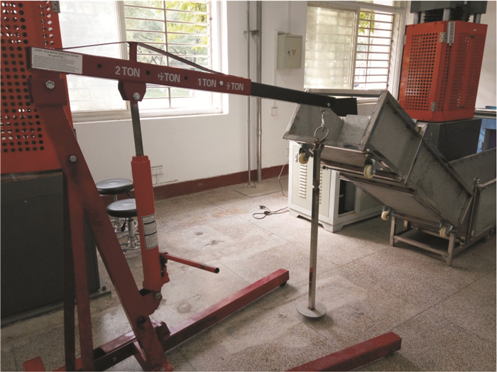
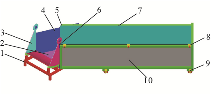
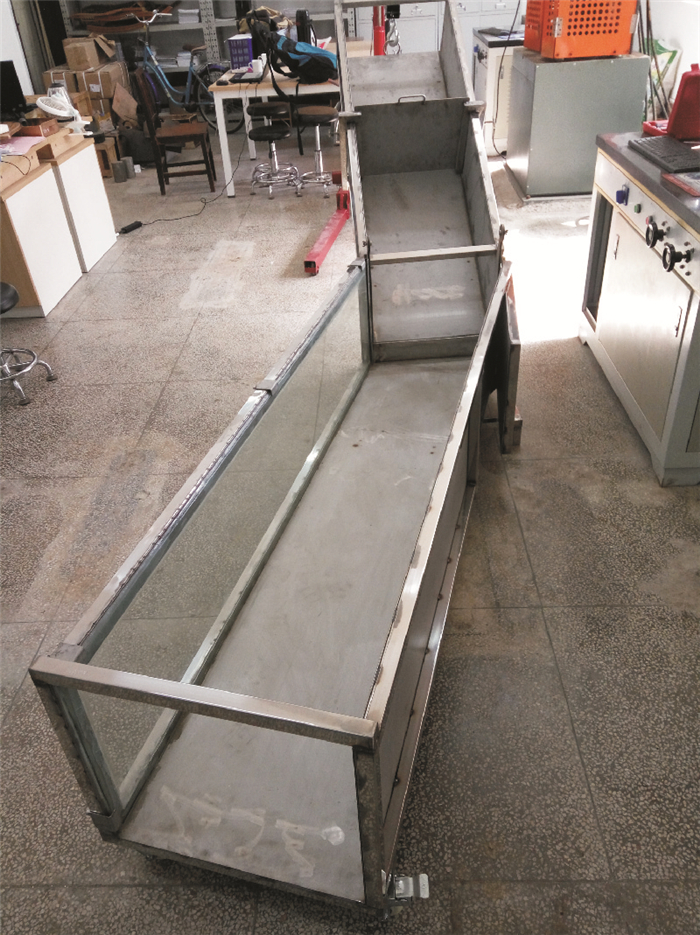
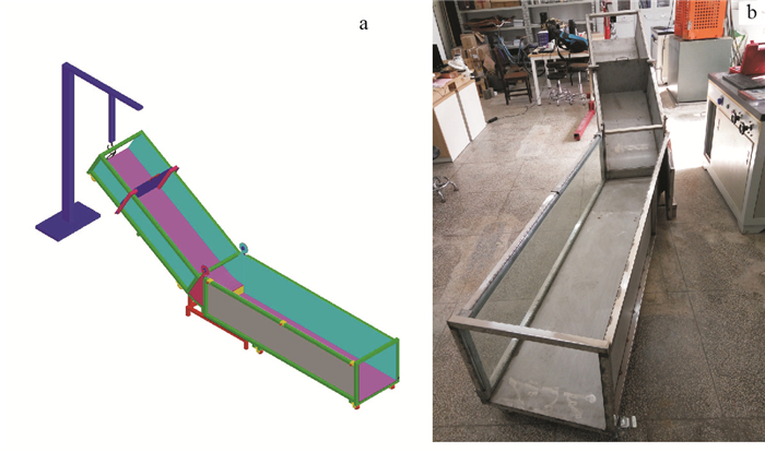
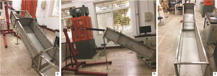
Abstract:
There are many factors affecting the movement and accumulation process of rapid long-runout landslide. During the developing the physical model test device, it is necessary to meet the needs of multi-factors, so as to achieve multi-functional purposes. The device is 3.40 m long, 0.56 m wide and 1.35 m high in initial state (vertical angle=20° and horizontal angle=0°). The design includes three modules: volume adjustment of slide body, slope adjustment of upper slide groove and horizontal angle adjustment of horizontal slide groove. Two kinds of materials, 3 mm thick stainless steel plate and 8 mm thick tempered glass, are used as the processing raw materials, leading to good durability. Moreover, the universal wheel is installed in the form of component assembly to facilitate the handling of the experimental instrument. Based on sand and pebble granular materials, the physical model tests with respect to the movement and accumulation process of rapid long-runout landslide are preliminarily carried out by using the developed device. The effects of slope, horizontal angle, height of sliding body and base material on sliding distance are briefly analyzed.
Sedimentary process and accumulation mechanism of traction fluidization gravity flow: An example from Qikou Sag, Bohai Bay Basin
Wang Hua, Chen Si, Gong Tianhao, Yu Zhenghong, Huang Chuanyan, Zhang Yuehui, Zhao Rui
2020, 39(1): 95-104. doi: 10.19509/j.cnki.dzkq.2020.0111
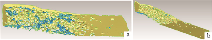
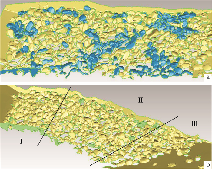
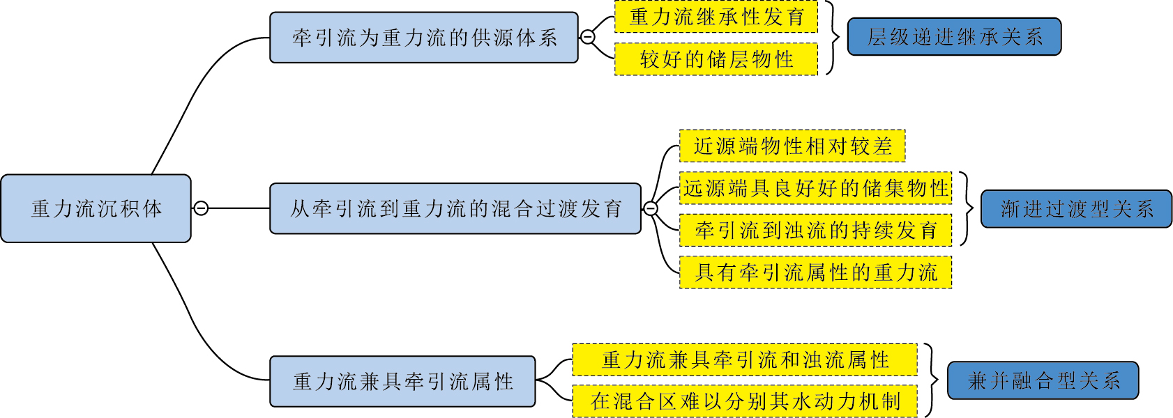
Abstract:
The high efficiency reservoir in gravity flow deposits with traction flow features is one of the most important aspects in sedimentary research and exploration. The large-scale and multi-stage lacustrine gravity flow deposits developed in the first member of Shahejie Formation in Qikou Sag of Bohai Bay Basin exhibit their unique sedimentary features (The dimensions of gravity flow deposits are about 940 km2 in transverse area and 1.1 km in vertical scale). According to the hydrodynamic conditions and sedimentary process mechanism, the large-scale lacustrine gravity flow depositional system shows three types of relationships between tractive currents and gravity currents, which are identified as ①hierarchical progressive inheritance type, ②progressive transition type, ③merger fusion type. The sedimentary mechanism of gravity flow is divided into five types: muddy debris flow, sandy debris flow, transitional contemporaneous flow, high/low-density turbidity flow and high/low-density quasi-steady turbidity flow. The channelized gravity flow depositional system with gravity flow channel is the dominant feature in the central uplift zone of coastal area in the west, as the sheet-flow pattern is controlled by the sub-sag morphology in the east. This study aims to realize and refine the integration and relevance among sedimentary dynamic process, accumulation mechanism, sedimentary facies, and lithofacies, as well as determine the dominant control factors for the traction fluidized gravity flow. As a potential efficient reservoir target, the research results of traction fluidized gravity flow deposits can improve the theoretical system of lacustrine gravity flow, and at the same time, are significant for frontier breakthrough in petroleum exploration.It has practical production value and important reference for other continental lake basin oil and gas exploration.
Productivity and development model of source rock of the Liushagang Formation in the Weixinan Sag
Ye Jiaren, Zhao Niubin, Yang Baolin, Xu Jianyong
2020, 39(1): 105-113. doi: 10.19509/j.cnki.dzkq.2020.0112
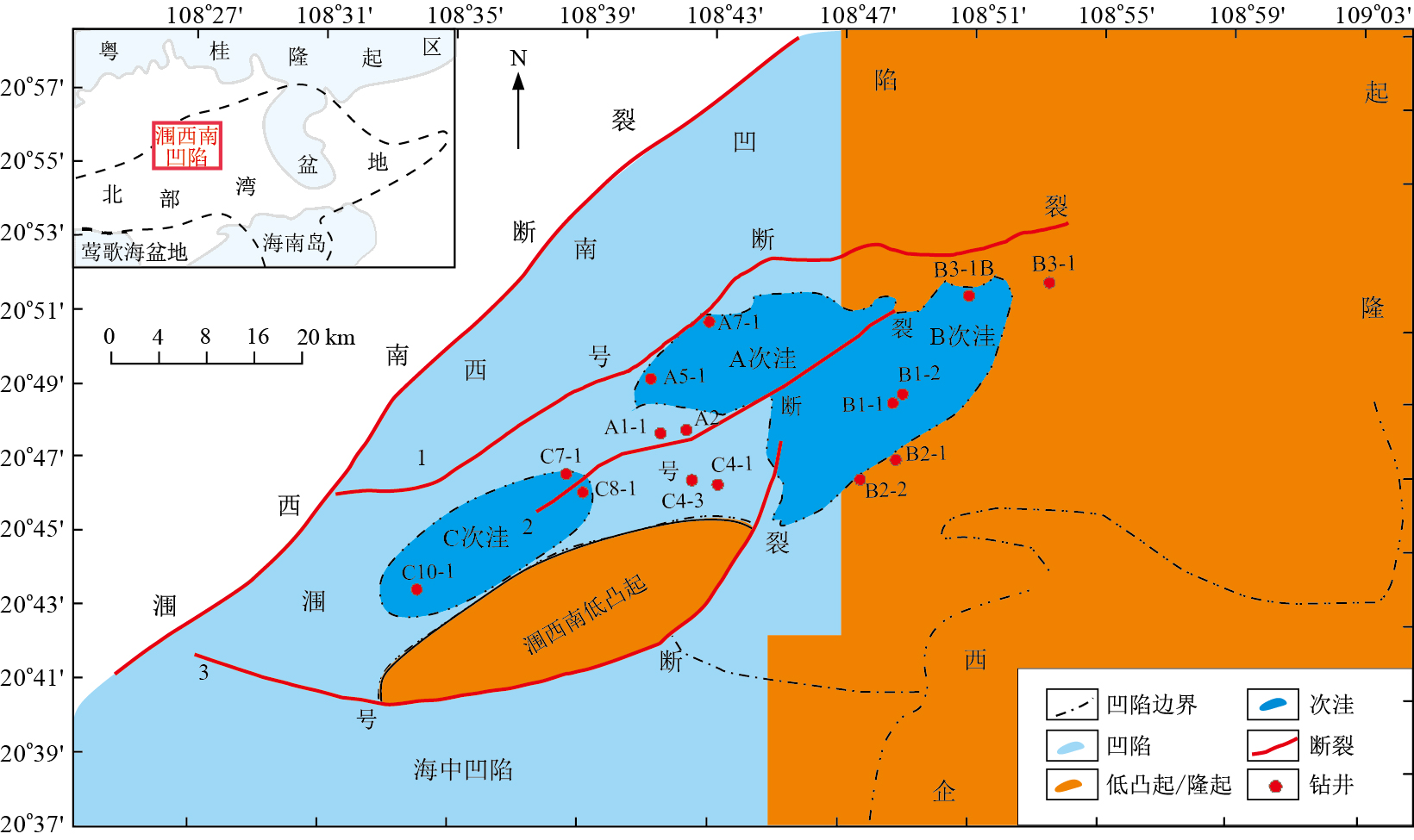
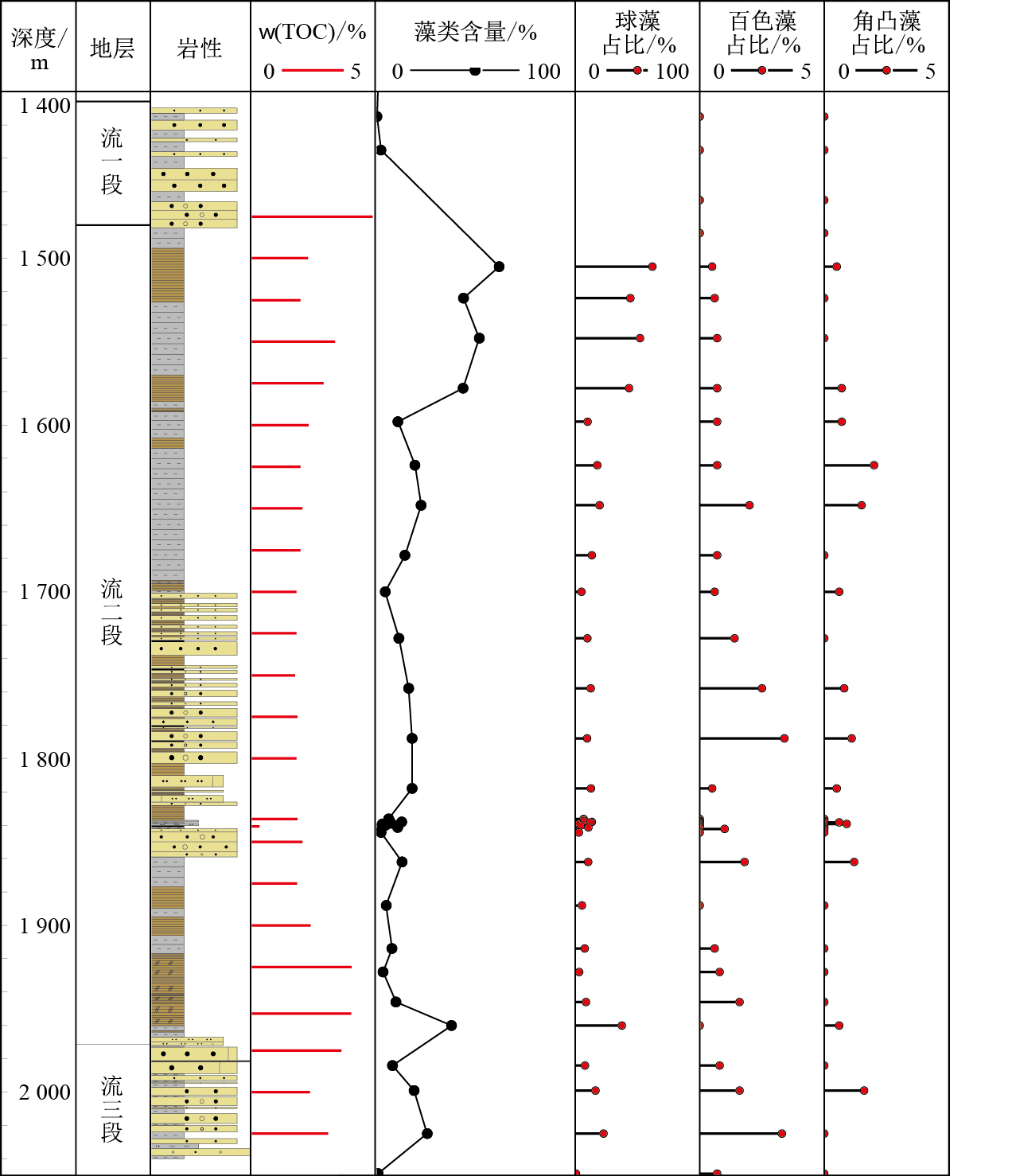
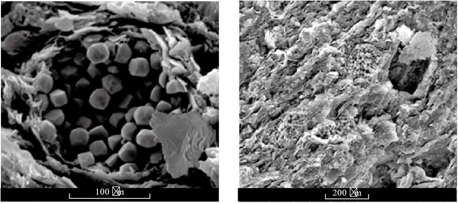
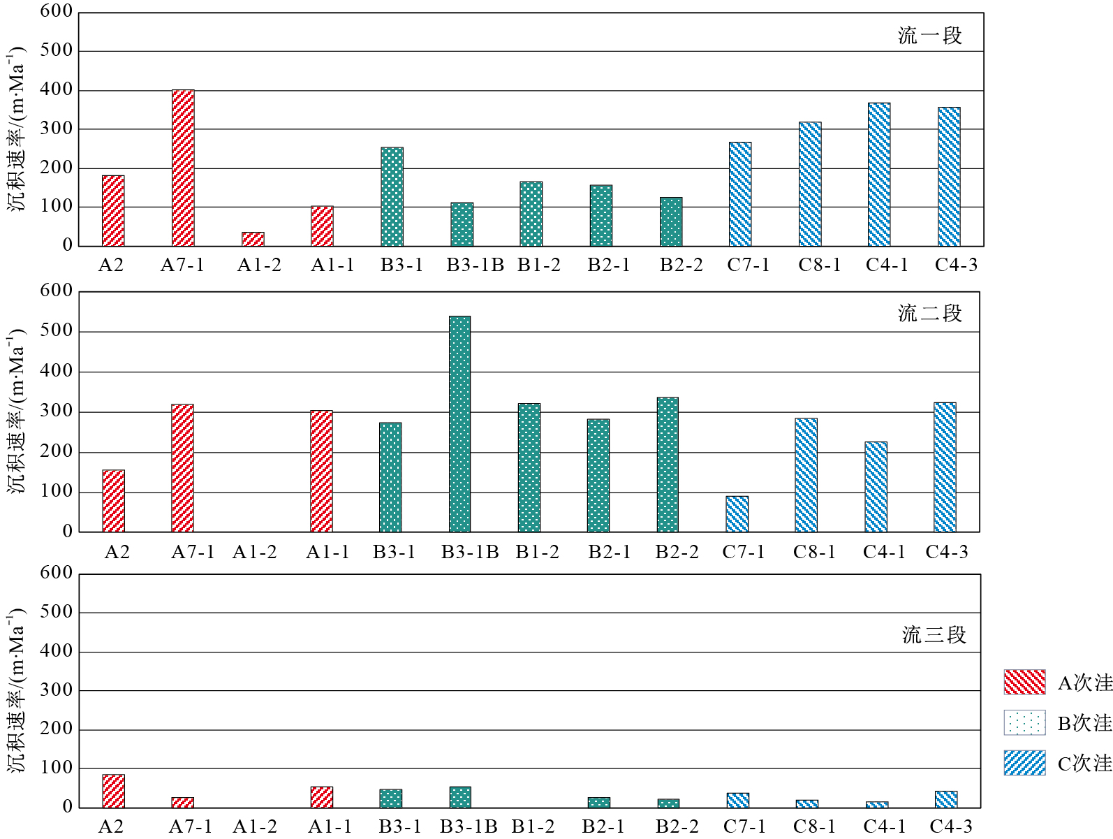
Abstract:
The Weixinan Sag is a proven hydrocarbon-rich sag with the Eocene Liushagang Formation as main source rock system in the Beibuwan Basin, offshore China.In order to deepen the understanding of the productivity and development characteristics of the Liushagang Formation source rock, the paleo-productivity, organic matter burial efficiency and organic carbon burial productivity of each sub-sag in the Weixinan Sag and each member in the Liushagang Formation are restored forward by using the methods of organic geochemistry combined with geobiology and qualitative analysis combined with quantitative calculation, and the geobiological development models of the Liushagang Formation source rock are further established.The results show that there are differences in paleo-productivity, organic matter burial efficiency and organic carbon burial productivity among different sub-sags in lateral and vertical directions.The B sub-sag is the best in plane and the E2L2 is the highest in vertical sequence.Three representative geobiological development models of the Liushagang Formation source rocks can be summarized as the hypertrophic lake with high burial efficiency and burial productivity, the eutrophic lake with medium burial efficiency and burial productivity, and the eutrophic lake with low burial efficiency and burial productivity.
Preliminary discussion on the theory of ore-forming field and its significant role for mineral exploration
Wei Junhao
2020, 39(1): 114-129. doi: 10.19509/j.cnki.dzkq.2020.0113
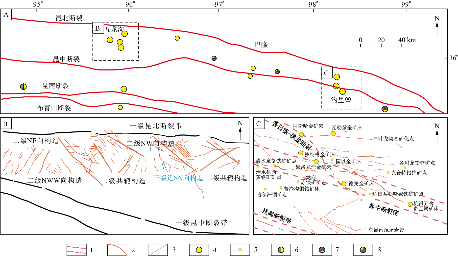
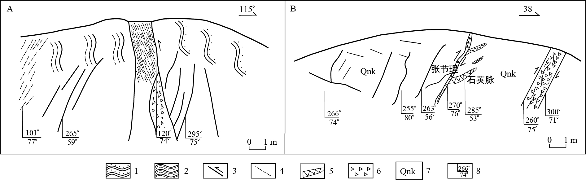
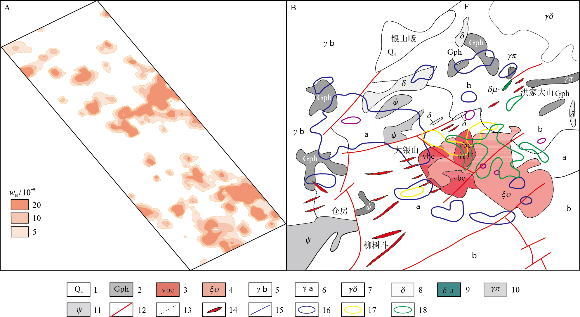
Abstract:
The ore-forming field is a geological term including the stress field that caused rock deformation in a certain ore-forming area, the fluid field that controlled the migration of ore-forming fluids, and the material field that consisted of migration, precipitation, enrichment and superimposition of ore-forming elements in a certain geological period.The spatial relations, research contents and research methods of stress field, fluid field and material field in a metallogenic area are studied.According to the metallogenic background, controlling factors and metallogenic environment, ore-forming field can be divided into seven types, namely thrust (nappe)-post extensional tectonic setting, strike slip-extensional (extensional-strike slip) tectonic setting, intermediate acid volcanic (subvolcanic) magmatism environment, mafic-ultramafic magmatism context, basin rift-submarine exhalation setting, exogenetic marine sedimentary formation environment, and exogenetic continental sedimentary formation context.The first five categories (dominantly endogenous mineralization) are systematically elaborated.The key geological factors in the mineral exploration process for these five types of ore forming fields are then summarized, which are important in guiding the specific mineral exploration work.
Distribution and differential entrapment mechanism of the oil-water interface within Ordovican in the west part of Lungu buried hill oil field
Cai Zhongxian, Yu Congling, Yang Haijun, Zhang Haizu, Yuan Yuchun
2020, 39(1): 130-136. doi: 10.19509/j.cnki.dzkq.2020.0114
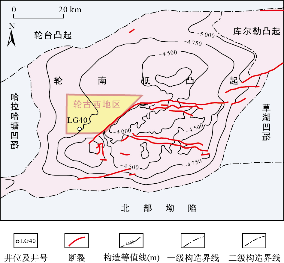
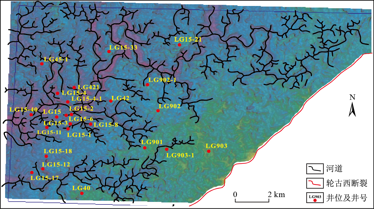
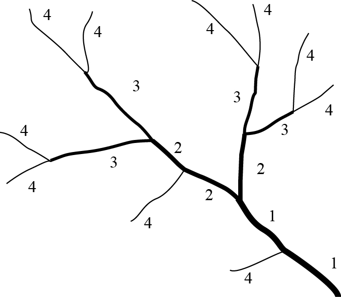
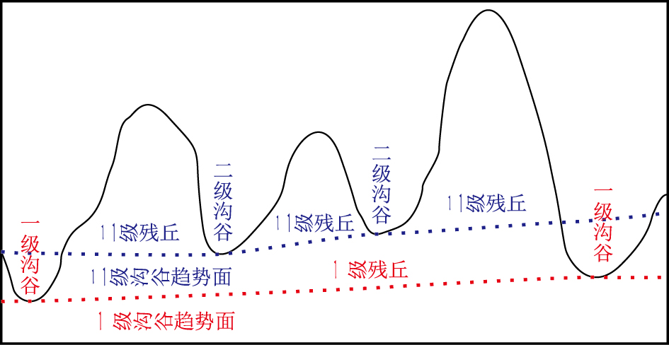
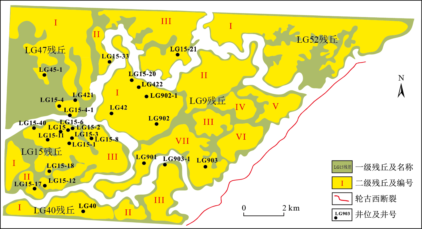
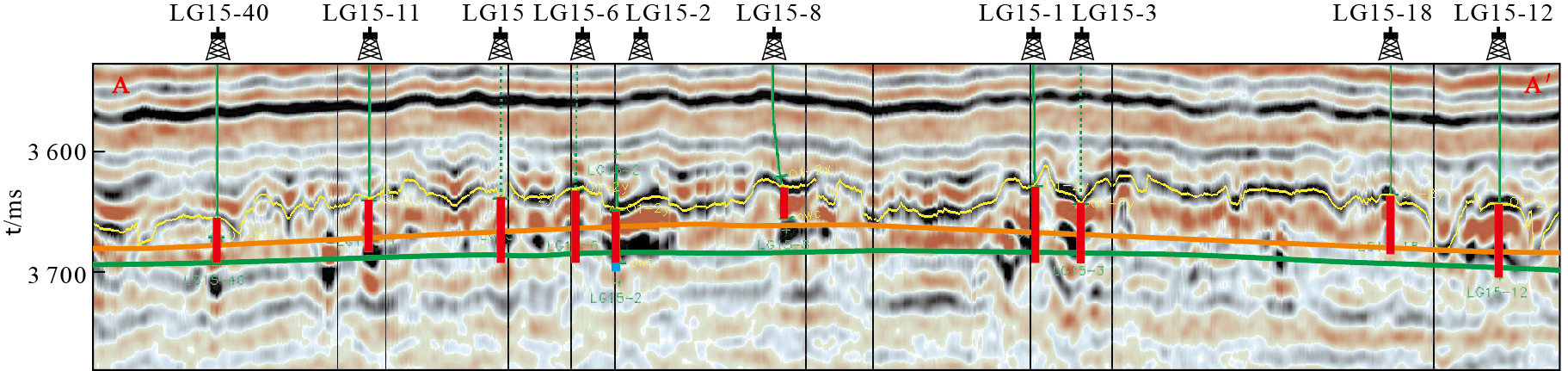
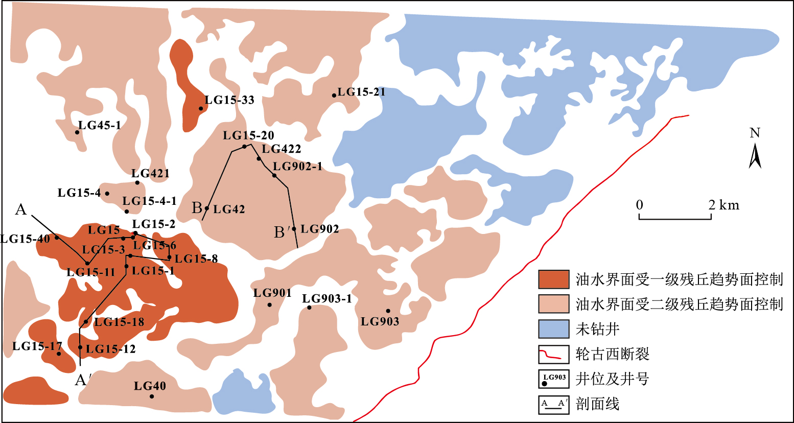
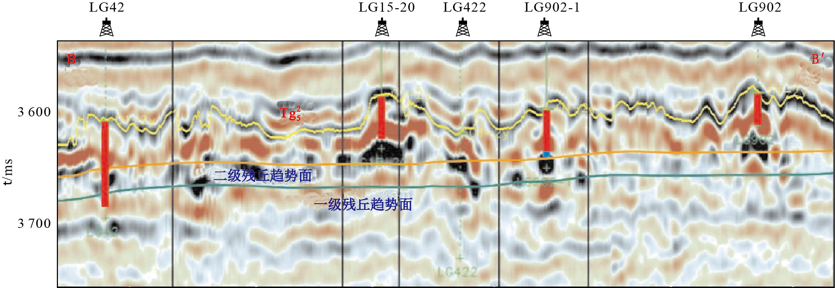
Abstract:
The distribution of oil-water interface in the west part of Lungu buried hill oil field is very complicated because of its heterogeneity of karst-modified carbonate reservoir.In this study, we use some methods including geomorgraphy and the seismic attribute extraction techniques to sub-divided the river rank of fluviokarst, then perform the trend surface analysis for different rank of rivers to grade the karst monadnock.We also use direct, static pressure crosscoupling and the original formation pressure methods to calculate the oil-water interface of each well.The corrletion between trend surface to oil-water interface of wells shows that the first- and second-grade trend surface influence the distribution of oil-water interface in different monadnock.From Lungun 15 well area in southwest to Lungun 9 well area of middle part, The oil-water interface rise from the first- to second-grade trend surface of monadnock, influenced by fault which resulted in complicated oil-water interface of some wells.This distribution characteristics can not be completely explained by classical theory of differential entrapment because of its reservoir heterogeneity besides spill-point determined from karst river valley.High hydrocarbon-producing well tend to be controlled by the first-grade trend surface of monadnock.
Research status and perspective on wellbore sand production from hydrate reservoirs
Ning Fulong, Fang Xiangyu, Li Yanlong, Dou Xiaofeng, Wang Linjie, Liu Zhicao, Luo Qiang, Sun Jiaxin, Zhao Yingjie, Zhang Zhun, Liu Tianle, Zhang Ling, Jiang Guosheng
2020, 39(1): 137-148. doi: 10.19509/j.cnki.dzkq.2020.0115
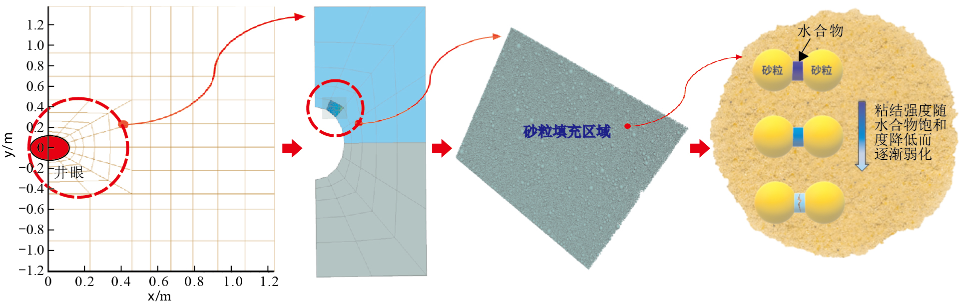
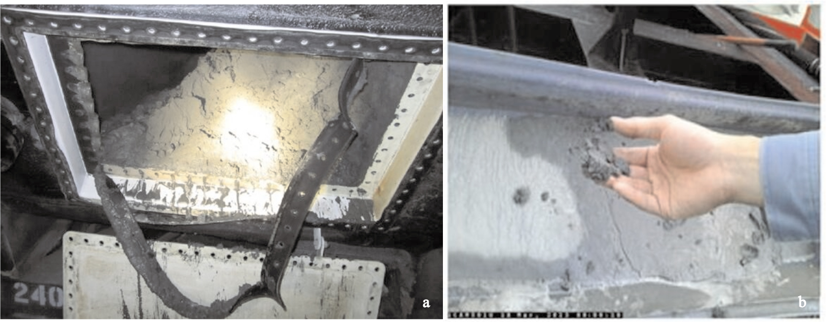
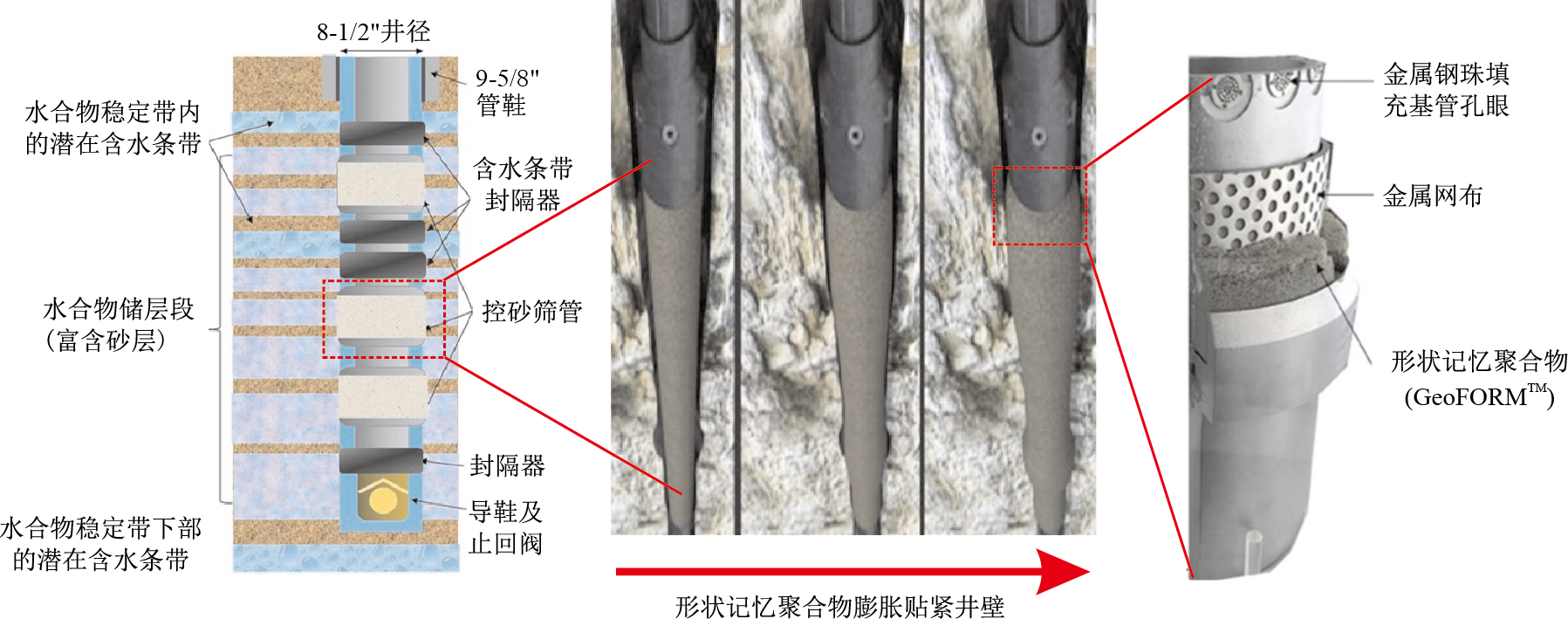
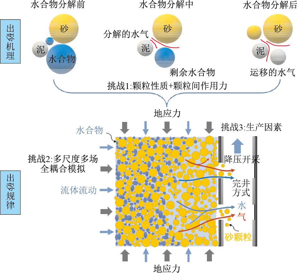
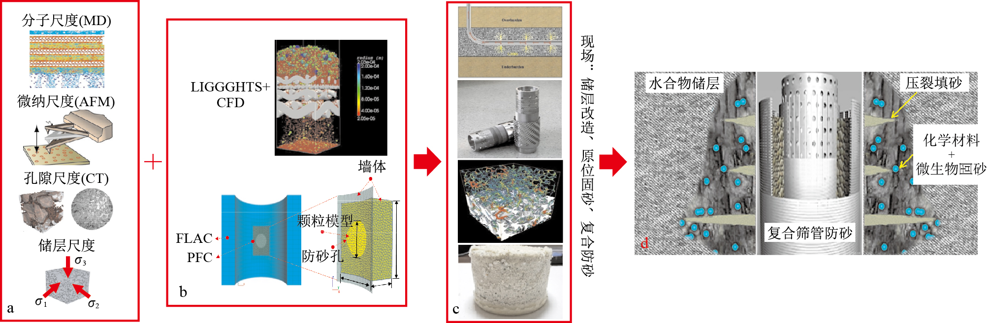
Abstract:
Sand production problem during gas hydrate exploitation seriously restricts its safe, efficient and controllable exploitation and industrialization process.It becomes one of the bottlenecks which should be solved urgently.The typical hydrate reservoirs in the South China Sea are clay-rich silt formation which cause more prominent contradiction between sand/clay production control and gas recovery enhancement.To resolve this conflict, we should firstly clarify the sand production behaviors and reveal their mechanism under the conditions of different reservoir types and production rules, and then formulate scientific and reasonable sand/clay control methods to maximize the gas recovery rate.This paper reviews the research status of wellbore sand production during gas production from hydrate reservoirs.Theoretical analysis, numerical simulations, laboratory experiments and field trials for sand production prediction and control are summarized respectively.Then the influencing factors of sand production in hydrate reservoirs, the mechanism of sand production, and the difficulties and challenges of sand production research are analyzed.The aim of this review is to provide some suggestions and ideas for sand production prediction and scientific sand control technology in the following hydrate exploitation process.
The thrust-decollement structure in western Guizhou and its control of Pb-Zn deposit
Yang Kunguang, He Lianglun, Liu Yu, Ren Houzhou
2020, 39(1): 149-156. doi: 10.19509/j.cnki.dzkq.2020.0116
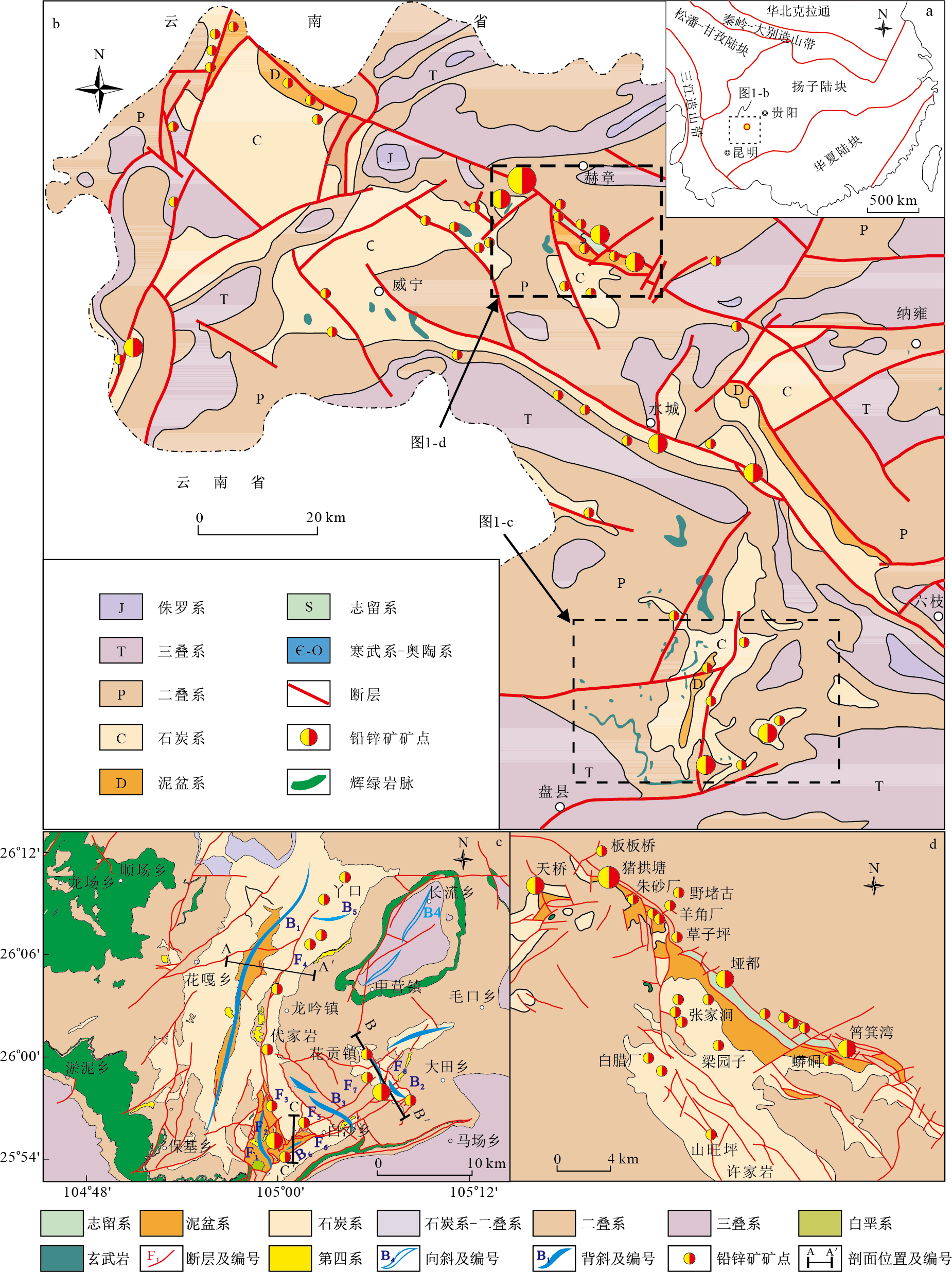
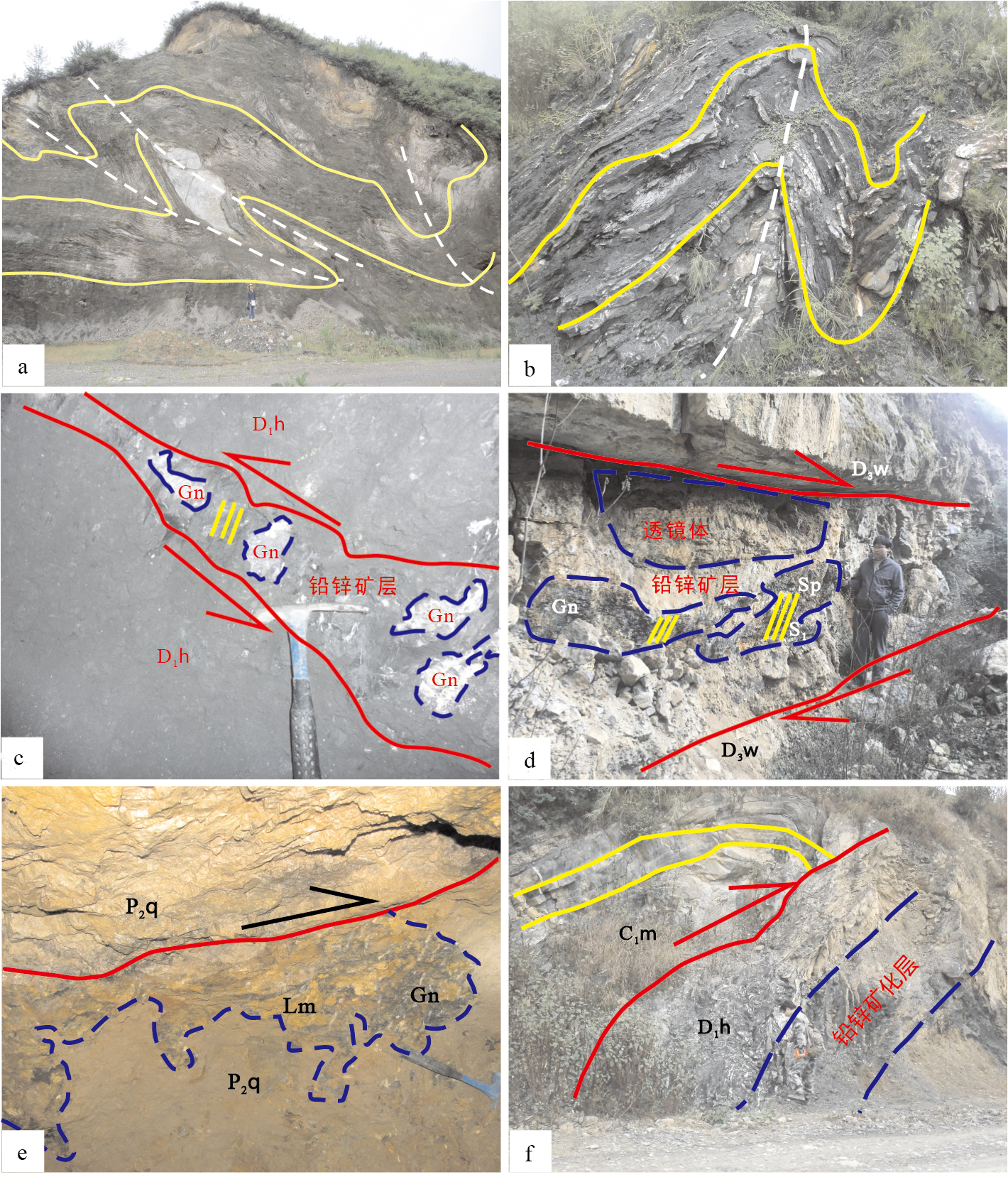
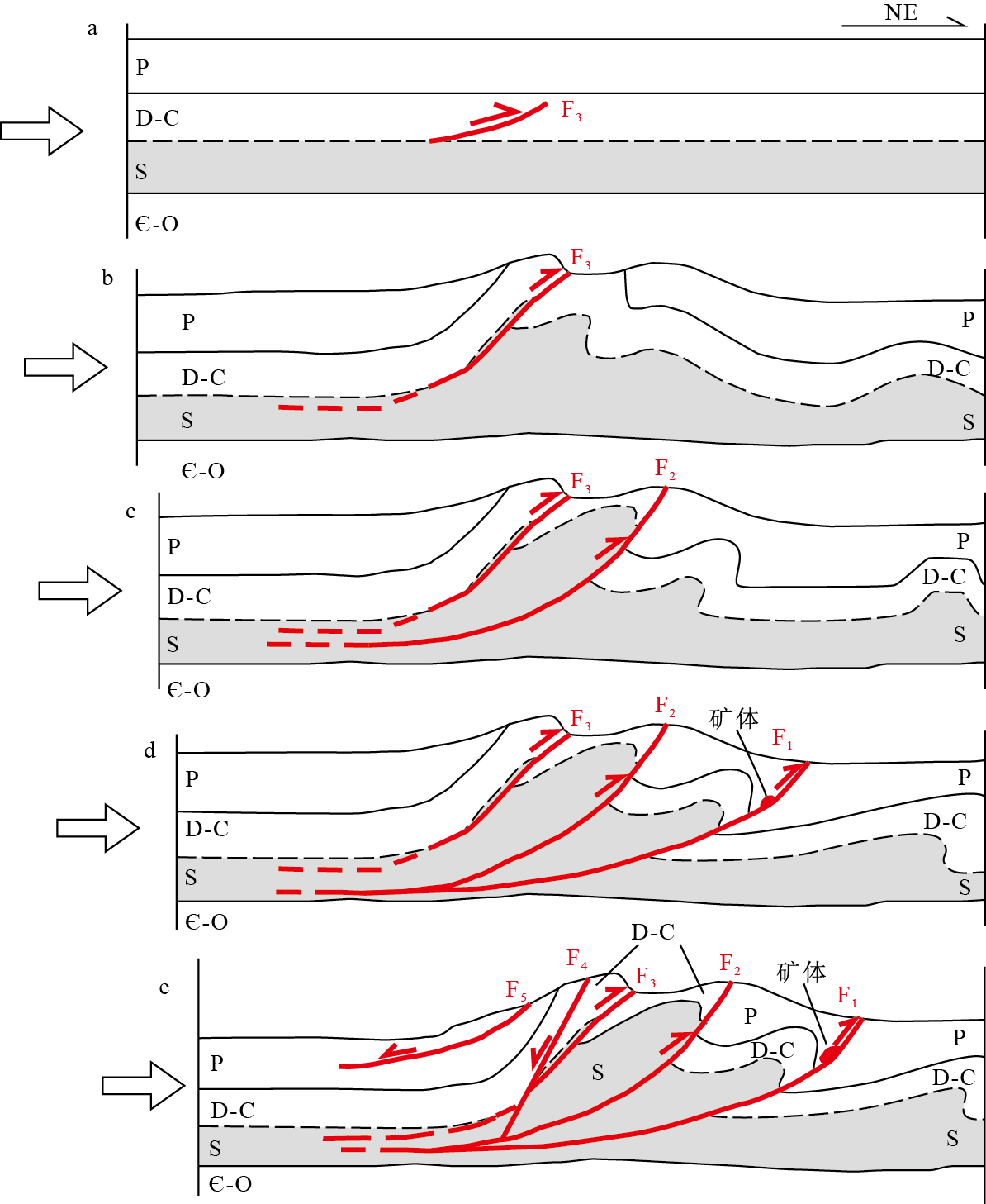
Abstract:
The western Guizhou area is located in the southwest margin of the upper Yangtze Block, which is influenced both by the Tethys tectonic process and the Pacific tectonic process. The most widely exposed sedimentary rocks in this area are mainly the Middle and Upper Devonian-Lower Triassic (D2-T1) carbonate. The Lower Devonian and Silurian shale and siltstones are overlaid to constitute the bottom detachment layer in this area. Shale, siltstones and carbonaceous shale in D2-T1 carbonate hard rock form the secondary detachment layer. In the Mesozoic, due to the remote recombination of the above two tectonic process, many tectonic activities and superimposed deformation occurred in western Guizhou. In the extrusion process, the decollements between the hard and the weak layer formed the complex tectonic pattern. The different scale thrust-decollement in different stage (interlayer decollement-multi detachment-small thrust-large thrust) has different effects for Pb and Zn enrichment. Pb and Zn enrichment was formed by interlayer decollement in accordance with bedding. Furtherly, multi detachment (small thrust) controls Pb-Zn enrichment slightly steeper than the strata. Small parallel displacement or tensile faults control the enrichment of steeply dipping lead-zinc deposits, whereas the large thrust faults control the enrichment of large and very large Pb-Zn deposits. Therefore, the thrust-decollement is the most important factor to control the enrichment of Pb-Zn deposit in western Guizhou.
Thinking and methods of intelligent supervision of urban geological environment based on big data
Wu Chonglong, Liu Gang, Wang Lizhe, Zhang Zhiting
2020, 39(1): 157-163. doi: 10.19509/j.cnki.dzkq.2020.0117
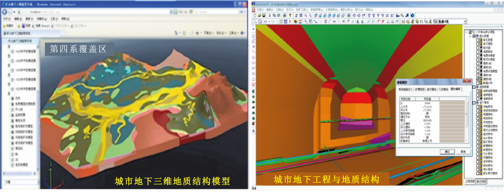
Abstract:
With the acceleration of urbanization, the rapid expansion of scope, the rapid expansion of population, the proliferation of high-rise buildings and the large-scale development of underground space, they are faced with great challenges, such as the dilution of water resources, the deterioration of geological environment and the frequent occurrence of geological disasters.In order to meet the challenge effectively, it is urgent to carry out fine and holographic three-dimensional geological modeling oriented to "intelligent city" on the basis of urban multi-factor geological environment survey and establishment of perfect information system, that is, to establish a new type of urban "glass land", to realize the temporal and spatial perspective of urban geological environment, and then to establish urban geological resources by using sensors, Internet of things and cloud technology.Finally, based on the assimilation, fusion and mining technology of geological science big data, intelligent early warning and control are carried out.
Data model for geological spatiotemporal big data expression and storage management
Liu Gang, Wu Chonglong, He Zhenwen, Weng Zhengping, Que Xiang, Tian Shanjun, Li Yang
2020, 39(1): 164-174. doi: 10.19509/j.cnki.dzkq.2020.0118
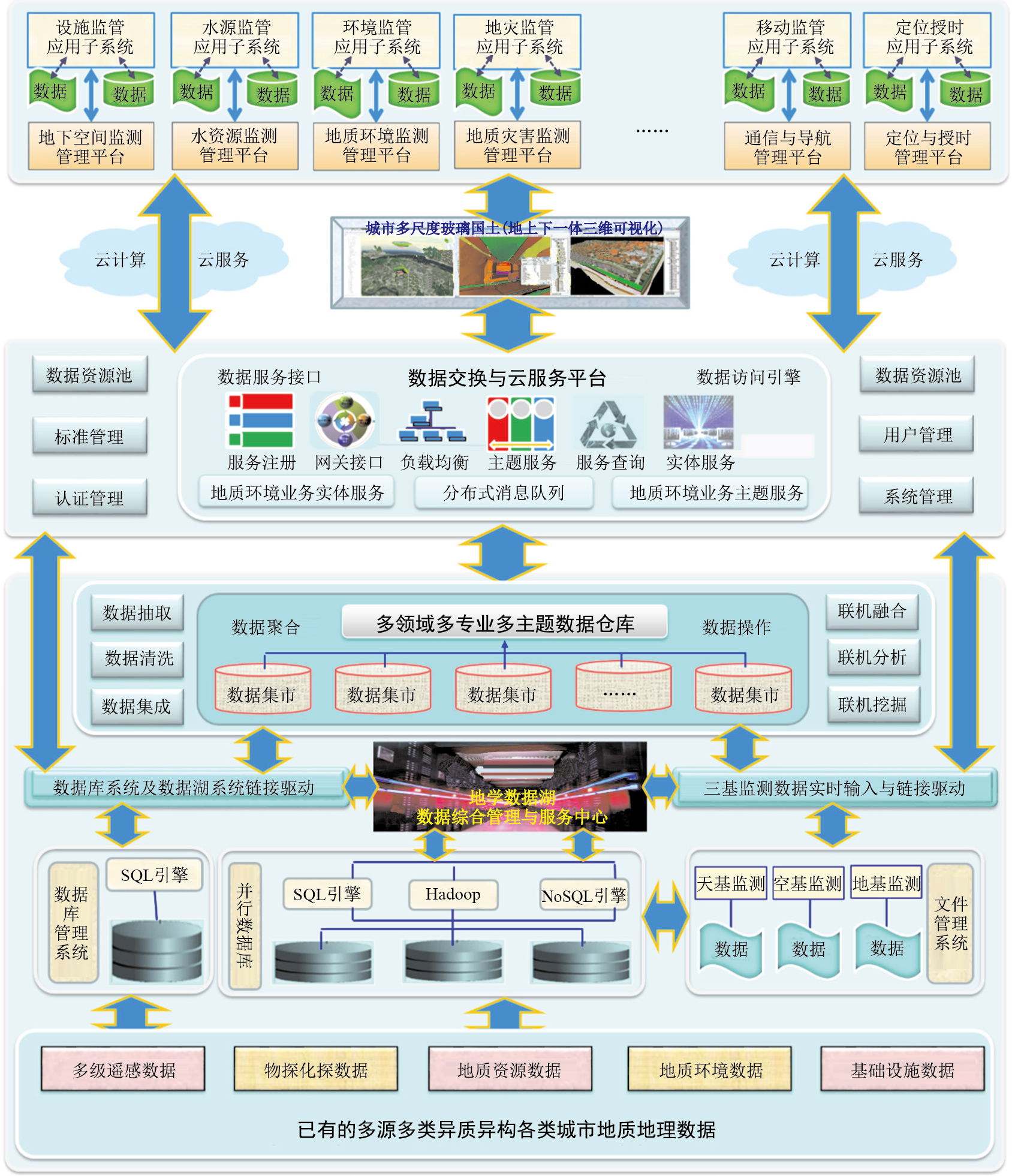
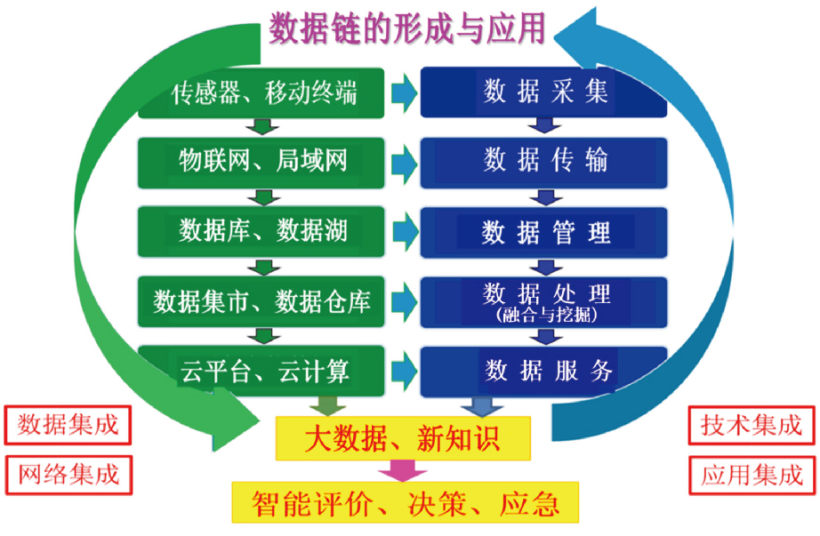
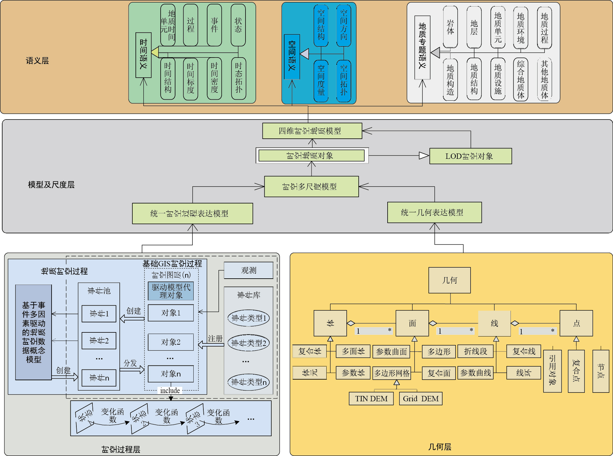
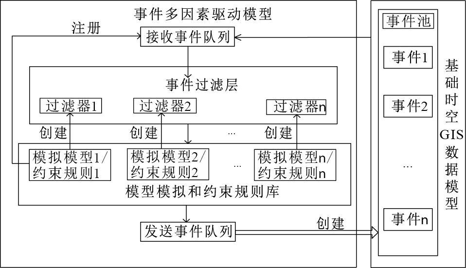
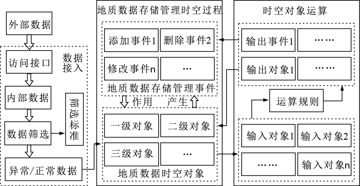
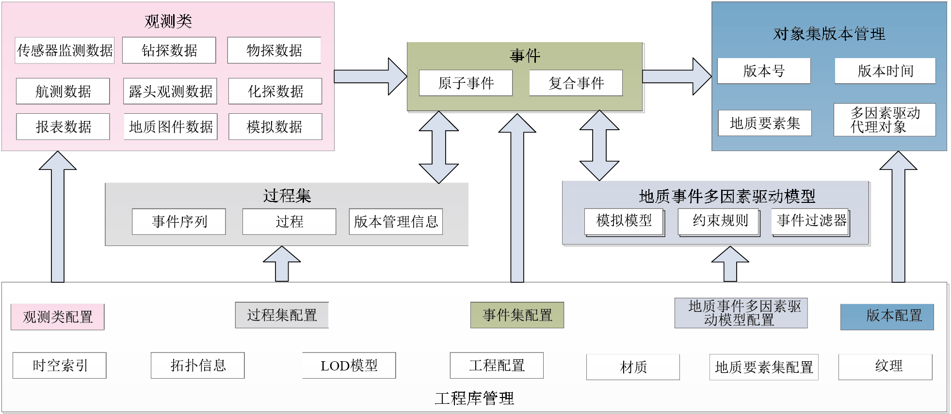
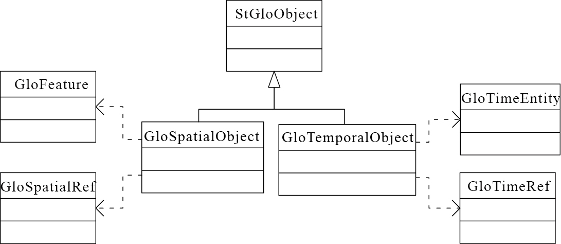
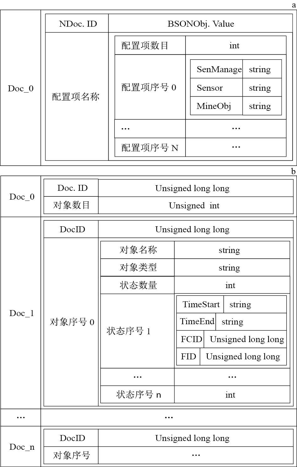
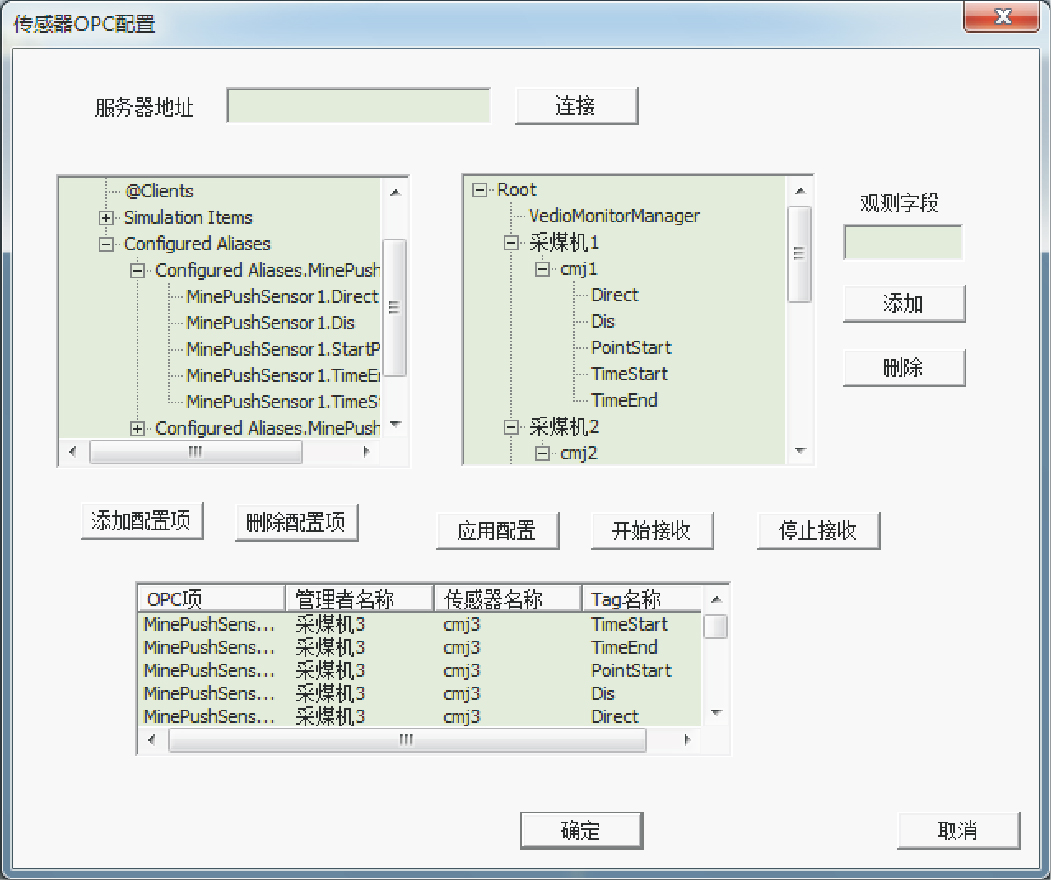
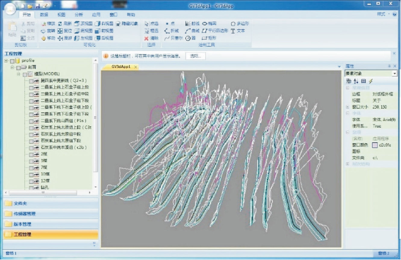
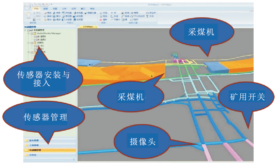
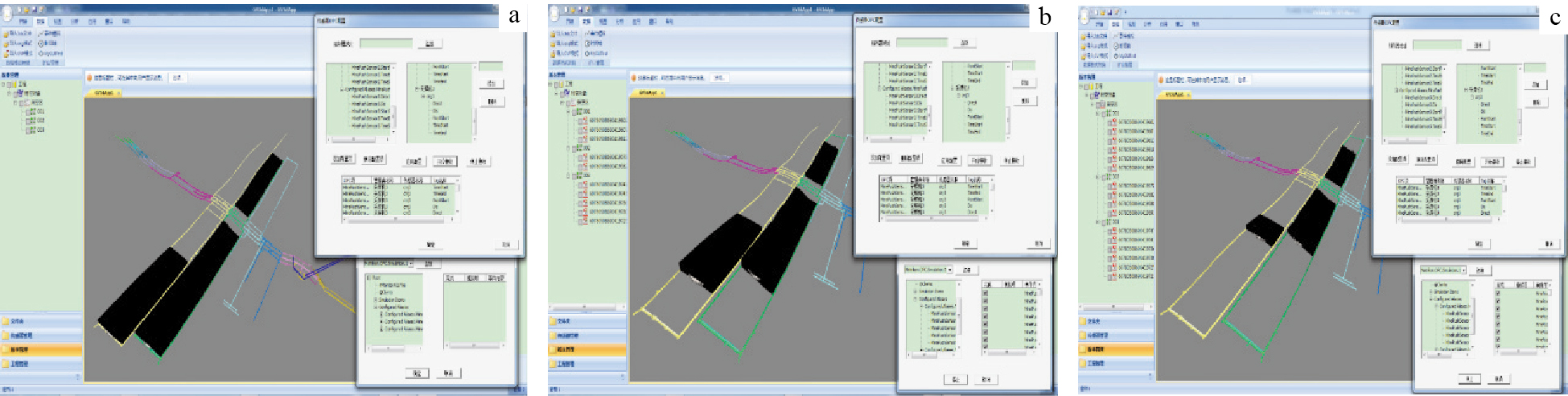
Abstract:
Geological big data is a typical spatiotemporal big data.Most of present geological information systems only support the storage and expression of the static status of geological exploration or production in a specific period.However, with the development and application of multiple sensors, real-time monitoring and other high-tech in the geological exploration, which results in more and more dynamic and multi-source heterogeneous geological data being produced.In practical application, it is in urgent need to deal with the real-time increasing big data in the geological exploration and production, which can strongly support the analysis and judgement of the geological process.In this paper, we study the traditional data model for geological spatiotemporal expression and storage management with the target of a new hybrid model, which can not only deal with the multi-sources and multi-dimensional data, but also support the time associated and time granularity.According to the characteristics of geological big data and the combinations of static and dynamic geological process data, we took both the object-oriented and event based method and put forward a geological event multi-factors driven model.We also designed the corresponding geological data logic model for distributed storage.Based on the geological data logical model and NoSQL database technology, we designed a non-relational distributed database schema.With the use of 3D geological modeling technology, real-time dynamic monitoring information visualization technology, we build a necessary virtual simulation environment for the hybrid model.By binding the observation data source, which is operation as an events emitter based on the OPC interface, the dynamic mining process is simulating as the geological objects responding to their corresponding events.Under the support of geological modeling data and reports and other data in the first mining area of Wang Jialing coal mine, we tried to implement the model application with multi geological spatiotemporal events.The results show that the data model is feasible, applicable for the expression and data management of mine dynamic mining process.
Automatic matching of ore body contour line based on equal-angle and variable proportion projection
Tian Yiping, Liu Weian, Zhang Xialin
2020, 39(1): 175-180. doi: 10.19509/j.cnki.dzkq.2020.0119
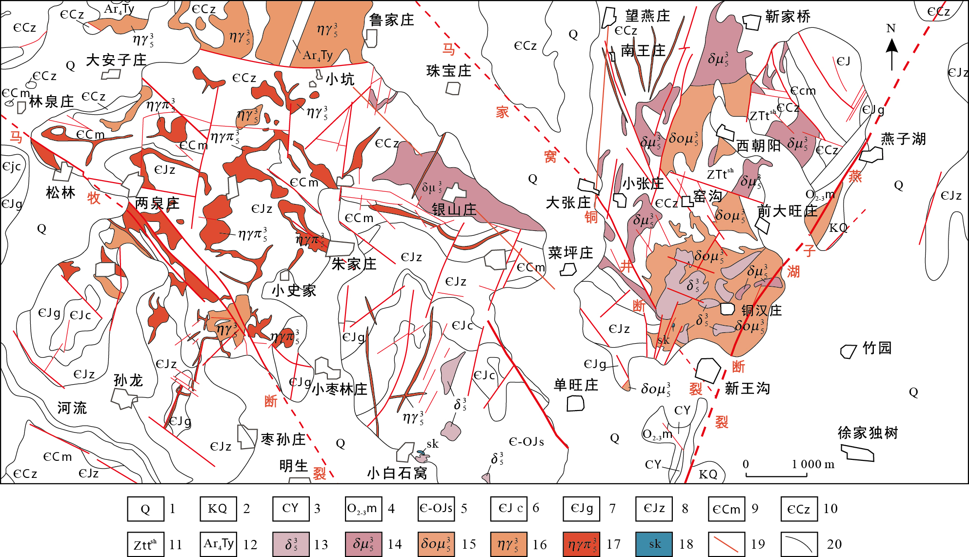
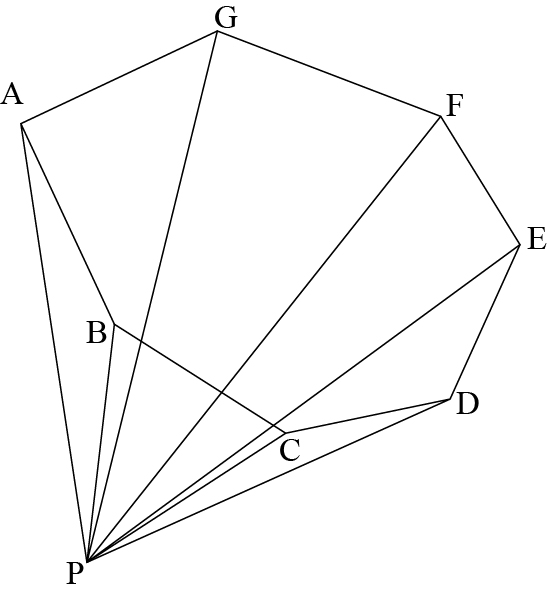
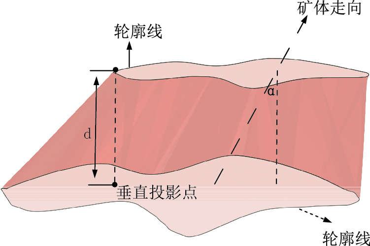
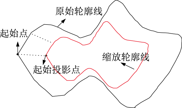
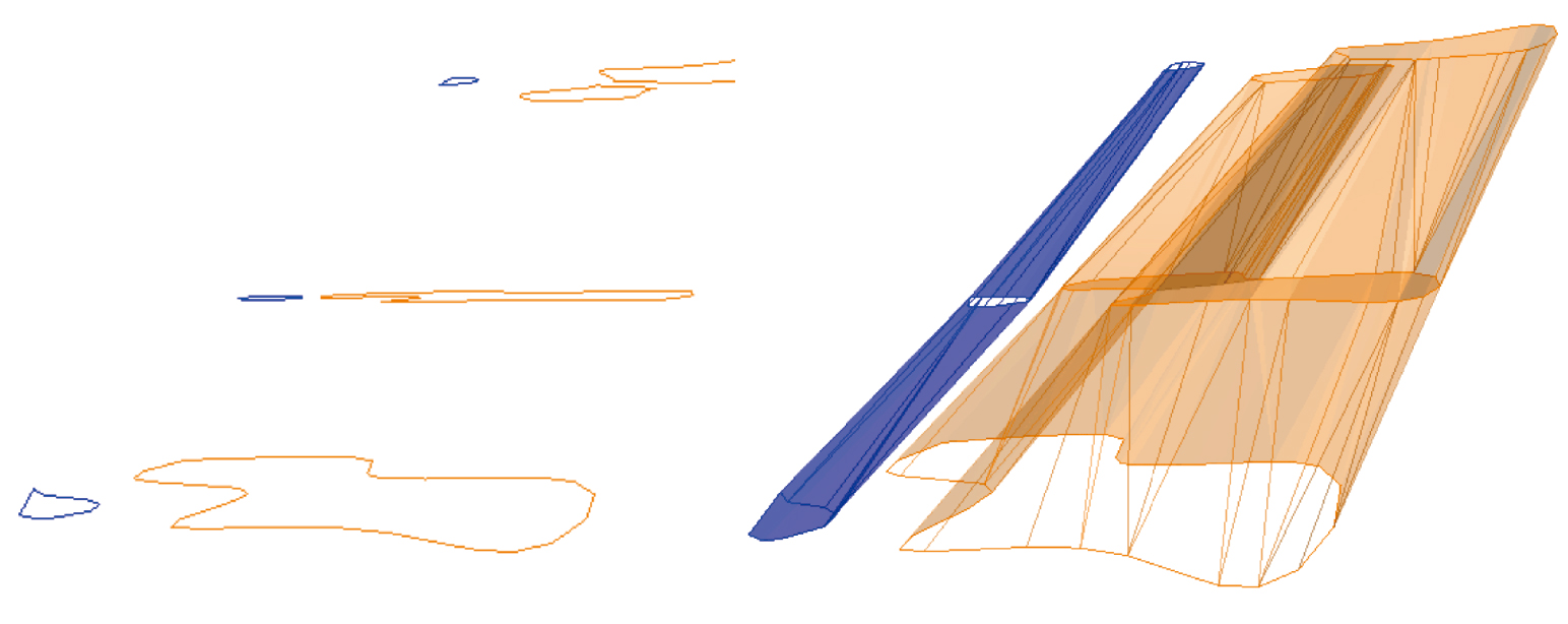
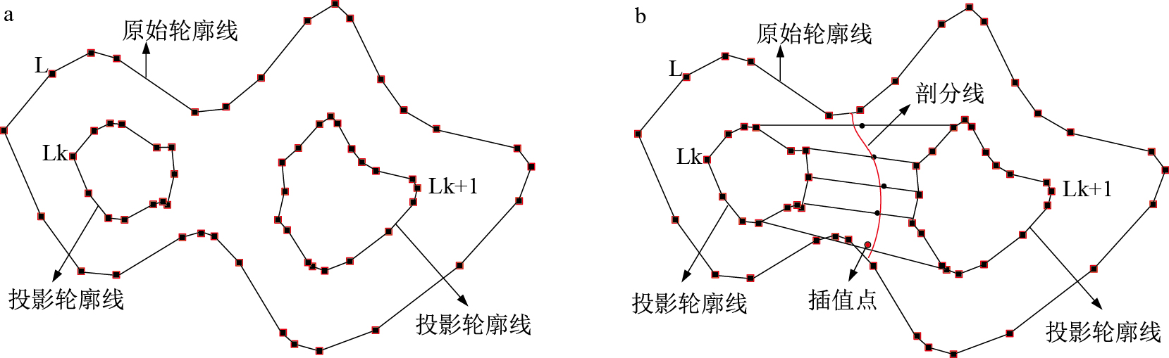
Abstract:
The main problems such as matching correspondence, branching and surface reconstruction in ore body three-dimensional modeling method based on contour lines are discussed in detail in this paper.To solve the problem of contour matching, an equal-angle variable proportion projection algorithm is proposed, which takes ore body trend as projection direction and takes ratio of contour total area of adjacent sections as scaling proportion.Contour lines of different sections are projected into a same plane to complete topological analysis of coplanar contour lines, so as to solve the matching correspondence problem of contour lines.In order to solve the branching problem of contour lines, an adaptive interpolation algorithm combining inverse distance weighted average and spline function is designed and implemented in this paper.Finally, the method proposed in this paper is validated effectively by using actual mine data modeling.