2021 Vol. 40, No. 4

Display Method:
CONTENTS
2021, 40(4)
Abstract:
Geological conditions and the main controlling factors for the tight oil accumulation in Liushagang Formation of Fushan Depression, Beibuwan Basin
Qin Qiuhan, Lei Dong, Song Xiaowen, Su Junqing, Ren Guiyuan, Liu Desheng, Ma Qinglin, Lu Zhenghuan, Guo Hao, Liao Feiyan, Shi Yang
2021, 40(4): 1-10. doi: 10.19509/j.cnki.dzkq.2021.0401
Abstract:
Unravelling the accumulation conditions and their controlling factors for the tight oil in the Liushagang Formation, Fushan Depression, Beibuwan Basin, is critical for the further evaluation of the tight oil distribution and the favorable exploration area.Based on comprehensive analysis of seismic, well logging, core and lab tests in this study, the effective source rocks, favorable reservoir, and the source-reservoir matching relations were investigated.It can be proposed that the high-quality source rocks were formed in Huangtong, Bailian two sub-sags during the maximum lake flooding periods in Liushagang depositional stage and were characterized as high organic content and moderate degree of thermal evolution, and thus they provide the material basis for the formation of tight oil; due to the influence of multi-source supply, tight sandstones penetrated into these two sub-sags and they were widely distributed with superimposed source-reservoir assemblages. The development of dissolution pores and structural fractures was favorable for the migration and enrichment of tight oil; the tectonic conditions of the sag were relatively stable and no major fault system was active when the main sources entered peak oil window, and thus the relatively stable tectonic environment enabled the formation and preservation of tight oil accumulations.Therefore, the Liushagang Formation of the Fushan Depression have favorable geological conditions for the formation of tight oil, which mainly distribute in the lower L1 submember and L2 member vertically and Huangtong and Bailian sub-sags horizontally.The distribution of high-quality source rocks, the distribution of "sweet point" reservoirs being rich in dissolution pores and favorable superimposed source-reservoir assemblages are the three main controlling factors for the formation and distribution of tight oil in Liushagang Formation of Fushan Depression, Beibuwan Basin.
Sedimentary characteristics and origin of moundes in Meishan Formation, southern Qiongdongnan Basin
Xiong Pengfei, Jiang Tao, Kuang Zenggui, Cheng Cong, Ren Jinfeng, Lai Hongfei
2021, 40(4): 11-21. doi: 10.19509/j.cnki.dzkq.2021.0427
Abstract:
While the Meishan Formation, southern Qiongdongnan Basin, has been widely discussed because of their unique mound-like reflection characteristics, there is still considerable controversy on the origin of those mounds. This study is based on a large number of 2D seismic data and high-resolution 3D seismic data in the Qiongdongnan Basin, combined with deep-water drillings, elucidates the mound-like reflection characteristics and discusses the origin of the Meishan Formation integrated among seismic facies characteristics, sediment source, transport channels, paleo-geomophic, sea level changes, and tectonic activity. The results show that during Middle Miocene, due to forced retreat, the sea level dropped to a lower level throughout the Qiongdongnan Basin, and the southern uplift was partially exposed and denudated provided a large number of sediments. During the Late Miocene, the regional tectonic activities caused the gravity instability in the southern uplift, and the sediments were transported to the basin center in terms of the turbidite channels. Subsequently, the mound-like reflection features at the top of the Meishan formation in the Qiongdongnan Basin were caused by turbidity erosion which provenance was provided by the sediments from the southern uplift. The further discussions on the origin of the mounds are not only helpful to better understand the formation of mound-like deposits, but also illustrate that the composition of those mound-like deposits is clastic sediments rather than reefs, which has great value for deep-water hydrocarbon reservoirs in the Qiongdongan Basin.
Fractal characteristics of pore-throat structure in tight sandstones using high-pressure mercury intrusion porosimetry
Wang Wei, Song Yuanjuan, Huang Jing, Li Yahui, Chen Zhaobing, Zhu Yushuang
2021, 40(4): 22-30, 48. doi: 10.19509/j.cnki.dzkq.2021.0402
Abstract:
Microcosmic pore-throat structure is an important factor affecting the characteristics of sandstone reservoirs.However, the pore-throat of tight sandstone is complex and heterogeneous, which is difficult to be effectively characterized by conventional tests.Therefore, it is necessary to use fractal theory to research the pore-throat structure of tight sandstone.In this study, through high-pressure mercury injection porosimetry and fractal theory, the pore-throat structure and fractal dimension characteristics of the Chang 7 tight sandstones in Jiyuan area of the Ordos Basin are studied, and the relationship between infection points on the fractal curves and pore-throat structure are discussed.And combined with casting thin section and scanning electron microscope, the causes of fractal characteristics from pore-throat are analyzed.The results show that there are obvious infection points on fractal curves, and the infection point is the peak value of pore size distribution, which representes the transition from the large pore-throat with good connectivity to the small pore-throat with poor connectivity.The average fractal dimension of small pore-throat is 2.24, and that of large pore-throat is 4.65.The heterogeneity of large pore-throat is obviously stronger than that of the small pore-throat.And the correlation between fractal dimensions of small pore-throat and pore-throat structure is good.The small pore-throats of tight sandstones mainly consist of intercrystalline pores and throats, which have poor connectivity, small radius and weak influence by diagenesis.Therefore, the fractal dimensions of the small pore-throat are low.The large pore-throats of tight sandstone mainly consist of residual intergranular pores and dissolution pores.The large pore-throat has good connectivity, large radius and obvious transformation by diagenesis.Therefore, the fractal dimension of the large pore-throat is high.
Research status and development trend of fractures in carbonate reservoir
Li Changhai, Zhao Lun, Liu Bo, Li Jianxin, Chen Yefei, Zhang Yu
2021, 40(4): 31-48. doi: 10.19509/j.cnki.dzkq.2021.0403
Abstract:
Fractures have a great impact on the oil and gas production of carbonate reservoirs.Much previous research have been done on the classification, genesis, controlling factors, identification and prediction of fractures in carbonate reservoirs.It is concluded that the classification, nomenclature and the meaning of some non-structural fractures are still controversial.The causes of fractures include tectonism, diagenesis, abnormal high pressure, denudation and weathering.The mechanism of grain size and porosity on the development of structural fractures still needs further study.Sedimentary facies has a certain influence on the development of structural fractures, but the lithology of the same sedimentary facies is complex, thus it is difficult to accurately reveal the formation mechanism of fracture development.Direct study on the influence of lithology on fracture development is more significant to reveal the fracture formation mechanism.The study of fractures based on diagenetic evolution sequence provides a basis for further discussion of controlling mechanism of rock on the fracture development.The controlling factors of the development of non-structural fractures such as bedding-parallel fractures, stylolites, abnormal high pressure fractures and dissolution fractures need to be further studied.In recent years, seismic has made little breakthrough in the field of fracture identification, and acoustic far detection technology has become the most potential technology in the field of unconventional logging.Fracture identification by conventional logging has always been the hot issue, and more than 40 different methods have been proposed by previous workers.Fracture prediction by using logging and seismic has the best reliability and it is the mainstream fracture prediction technology at present.Standardizing fracture classification, sorting out fracture genesis, deepening the study of the formation mechanism of structural fracture, strengthening the discussion of controlling factors of non-structural fracture, improving the fracture recognition rate of conventional well logging and predicting reservoir fracture by integrating existing fracture prediction technology are the important development directions of fracture research in the future.
Reservoir characteristics and pore evolution of the Lower Shihezi Formation in Duguijiahan zone, Hangjinqi area, Ordos Basin
Li Zhi, Ye Jiaren, Cao Qiang, Yu Hanwen, Zhang Wei
2021, 40(4): 49-60. doi: 10.19509/j.cnki.dzkq.2021.0404
Abstract:
The Duguijiahan zone in Hangjinqi area is an important target for natural gas exploration and development in the northern Ordos Basin.The Upper Paleozoic sandstone reservoirs in the zone have strong heterogeneity and large differences in gas saturation.This has great influence on the development characteristics and development of tight reservoirs.The study of pore evolution history is not systematic and thorough.Based on drilling cores, rock thin slices and related testing data, on the basis of statistical and comparative analysis of the petrological and physical characteristics of Upper Paleozoic sandstone reservoirs in Duguijiahan area, through the analysis of diagenesis, the main factors that control the development of reservoir pores are determined factors to reconstruct the pore evolution history of the main reservoir section.Studies have shown that the Upper Paleozoic sandstones in Duguijiahan area are mostly ultra-low permeability reservoirs, with high permeability sections with developed fractures locally; compaction and cementation are destructive to the evolution of the reservoir pores in the study area. The porosity reduction rate is 84.8% and 7.1%, respectively, and the dissolution is a constructive diagenesis, and the porosity increase rate is 9.5%; the present porosity of the He 1st member reservoir basically inherits the characteristics of the end of the Early Cretaceous, and the pore evolution has gone through early diagenesis. In stage A, compaction and cementation are rapidly reduced, and in stage B, continuous compaction is reduced.In the middle diagenesis, the dissolution and pore-enhancing effects of phase A coexist with compaction and cementation and the process of weak change in phase B.
Unconformable event and its tectonic significance at Middle-Late Mesozoic of Qiangtang terrane, Tibet
Du Lintao, Li Yalin, Liu Yang
2021, 40(4): 61-71. doi: 10.19509/j.cnki.dzkq.2021.0405
Abstract:
Uncomfortable event is significant to continent collision.Collision timing of Qiangtang-Lhasa terrane has always been controversial, because of the different definition of collision time.There are two definitions of collision time in terms of timing of uncomfortable event.One is connection with regional angular unconformity of collision suture zone at late Early Cretaceous(100 Ma), and the other is connection with angular unconformity in the basin edge with disappeared oceanic crust and initial touch of crust between continents at late Middle Jurassic(166 Ma).Focusing on the issue, this study researched unconformity of two difference definitions in Qiangtang Basin and they are Daoban 114 unconformity in Anduo area and southwest Beileicuo unconformity.U-Pb age of anshanite magmatic zircon is 77 Ma, combined with the collision timing of Qiangtang-Lhasa terrane research result, and we think strong interaction time between Qiangtang and Lhasa terrane was at late Early Cretaceous(100 Ma), continuous range 100-75 Ma.The maximum depositional age of continental stratum in Beileicuo area is 94 Ma.Synthesizing sedimentology, geochronology and attitude stratum, we think the strata deposited after 94 Ma and it was not late Middle Jurassic Biluocuo Formation but Cenozoic Kangtuo Formation.And then, initial touch of crust between Qiangtang-Lhasa terrane was not 166Ma but before 100 Ma.
3-D engraving of volcanic mechanism in the Tiantai slope of Xihu Depression and its formation mechanism
Wang Xueyi, Liu Qianghu, Zhu Hongtao, Hou Guowei, Qin Lanzhi
2021, 40(4): 72-80. doi: 10.19509/j.cnki.dzkq.2021.0406
Abstract:
The development and distribution of igneous rocks in the Tiantai slope of Xihu Depression have an important influence on reservoir reconstruction and tectonic evolution.According to the seismic characteristics and tectonic environment in the area, two types of eruptions are divided into center type and fissure type.Based on drilling data and 3-D seismic data, the seismic amplitude and variance cube thresholding dispaly, systematically depicting 3-D spatial and temporal distribution of Tiantai of volcanics and eruption phases, revealing the igneous rocks of Mesozoic to the Miocene period in Tiantai have intermittent development more features, and enrichment of volcanism in the Tiantai slope in the southwest.Two types of eruptive modes, the central type and the fissure type, are established in the area.The establishment of these modes is of great significance for correctly predicting the distribution of igneous rocks.Finally, the genesis of igneous rock mechanism is analyzed and discussed. It is found volcanic activities and tectonic movement influence each other, volcanic distribution of space and time and the fracture also has certain configuration relations.It is believed that fissure eruption may form oil and gas migration channel, is characterized by terrigenous central type eruption is helpful to form good reservoir space.Based on this study, it will be easier to find effective volcanic reservoirs in Tiantai area, which plays an important role in indicating petroleum exploration.
Research progress and prospects of the stages, genesis and fluid evolution of micro-fracture veins in petroliferous basins
Chen Shaowei, Liu Jianzhang
2021, 40(4): 81-92. doi: 10.19509/j.cnki.dzkq.2021.0426
Abstract:
Faults and fractures in sedimentary rocks are important channels for fluid activities in petroliferous basins.Different stages and types of mineral veins filled in fractures are the product of hydrocarbon-water-rock interactions, recording the formation process of faults and fractures fluid properties, components, sources, temperature and pressure fields, redox environment and other information in different stages of the process. They provide important clues to study the development of faults in sedimentary basins, the characteristics of fluid dynamic fields, physical and chemical environments.This paper systematically summarizes the basic methods of fluid activity tracing and evolution of fracture veins in petroliferous basins and their current geological applications, and believes that they are mainly concentrated in three aspects: First, through the petrological observation of diagenetic minerals filled with fracture veins, to analyze the type, structure and relative order of formation of diagenetic minerals; the second is to trace the nature, source, temperature and pressure of vein-forming paleo-fluids through geochemical tests such as isotopes, trace rare earth elements, and fluid inclusions of vein diagenetic minerals- redox environment, etc.; the third is to accurately determine the formation time of veins by testing radioisotopes of diagenetic minerals in veins(such as U-Pb, Re-Os, etc.), and discuss vein formation processes and hydrodynamic fields based on regional structural evolution environment and its dynamic evolution process.Finally, the problems of existing research methods are analyzed, and the future development trends and geological application prospects are discussed, in order to provide references for the study of the evolution of paleofluid in petroliferous basins and their relationship with hydrocarbon migration and accumulation and preservation.
Classification and evaluation of low-permeability sand reservoir based on micro-pore structure
Wang Xinguang, Zhang Chong, Zhang Hui, Yang Zhaoqiang, Peng Xiaodong, Zhao Nan, Wang Lei
2021, 40(4): 93-103. doi: 10.19509/j.cnki.dzkq.2021.0429
Abstract:
The undeveloped low-permeability oil reserves of the Liushagang Formation in the Beibu Gulf Basin are large, but the reservoir quality is poor. The existing classification standards for low-permeability reservoirs cannot meet the needs of fine reservoir evaluation and offshore development.Based on the experiments of constant rate mercury injection, high pressure mercury injection, NMR and seepage mechanism, this paper comprehensively analyzed the micro-pore structure and seepage characteristics, and optimized six kinds of reservoir evaluation parameters: reservoir quality index, fractal dimension of pore structure, mainstream throat radius, mean throat radius, percentage of movable fluid and change rate of threshold pressure gradient, meanwhile, the classification limit of various characterization parameters were determined by integrating with the reservoir quality index, reservoir seepage ability evaluation factors and specific productivity index constraint parameters. A comprehensive evaluation criterion for low-permeability oil reservoirs is established based on the Grey Relational Analysis method, which is divided into Ⅰ, Ⅱa, Ⅱb, Ⅲ and Ⅳ from good to bad.Carried out the grading evaluation of low-permeability reserves and the research results provide a theoretical basis for the analysis of the development potential, the research direction of the low-permeability reserves in Beibu Gulf Basin.The results show: types Ⅰand Ⅱa are relatively high-quality low-permeability reserves and have been put into large-scale development.Types Ⅱb and Ⅲ are extra-low-permeability reserves and are difficult to develop, which need to be formulated for experimental development by reasonable technical measures and development models.
Hydrocarbon generation characteristics and signification of source rock in different oil-rich depressions in the eastern part of the Bohai Sea
Yu Biao, Liu Jianliang, Yang Guili, Liu Keyu, Liu Xiaolin
2021, 40(4): 104-114, 130. doi: 10.19509/j.cnki.dzkq.2021.0407
Abstract:
There are numerous oil-rich depressions in the eastern part of the Bohai Sea, which have a large hydrocarbon generation potential.Due to differences in the formation and development of these depressions, the thermal evolution and hydrocarbon generation and expulsion characteristics of the source rocks in different depressions and intervals are quite different.By studying the burial history, thermal history, and hydrocarbon generation and expulsion history of multiple sets of source rocks in three oil-rich depressions in eastern Bohai Sea, this paper determines the source rock generation, hydrocarbon expulsion timing and evolution characteristics of the Bozhong Depression, Bodong Depression and Miaoxi Depression.The results indicate that: ① The thermal evolution of source rocks in individual tectonic units in the eastern Bohai Sea has a general end of "high in the west and low in the east".The earliest hydrocarbon generation time in the Bozhong Depression is 34.4 Ma, while that for the Bodong and Miaoxi depressions are 30.8 Ma and 14.2 Ma, respectively.The earliest hydrocarbon expulsion time of the Bozhong Depression is 27.8 Ma, while that for the Bodong and Miaoxi depressions are 20.9 Ma and 6.7 Ma, respectively; ② The source rock in the Bozhong Depression has a relatively high degree of thermal evolution, and now it mainly provides natural gas to the reservoirs, which provides a gas source for the formation of natural gas reservoirs and condensate gas reservoirs in the Bozhong area.The degree of thermal evolution in the Bodong Depression and Miaoxi Depression gradually decreases, which provides a large amount of oil source for the reservoirs.The marginal areas of the basin are mainly oil reservoirs.
Types, element occurrence forms and enrichment mechanisms of rhenium metal deposits
Zhou Chengjiao, Zhang Gangyang, Zhang Dingchuan
2021, 40(4): 115-130. doi: 10.19509/j.cnki.dzkq.2021.0431
Abstract:
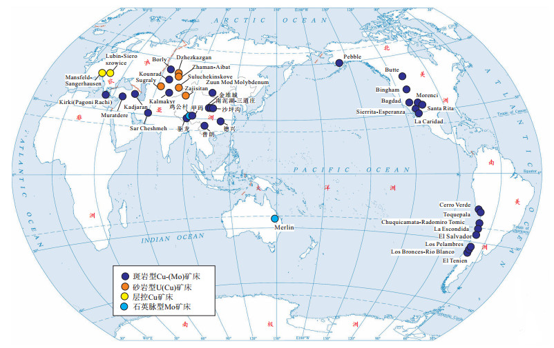
Rhenium is a strategic rare metal mineral that rarely forms independent deposits.Most of it is produced in the form of associated elements in the porphyry magmatic hydrothermal system.Studies have shown that rhenium-rich deposits are mainly distributed on the edges of active oceans or continental plates, and their genesis are mainly closely related to plate subduction or collision.The mineralization age of rich rhenium deposits is relatively new, mainly in the Himalayan and Yanshanian periods.There are about 11 independent rhenium minerals reported, mainly including natural rhenium, pyrite, copper rhenium, ruthenium rhenium, rhenium oxide, etc., among which rhenium sulfite is the main one.Most rhenium is mainly present in molybdenite in the form of isomorphism, followed by chalcopyrite, pyrite, wolframite. Rhenium-rich molybdenite is usually formed in a medium-low temperature hydrothermal system.Rhenium in molybdenite often shows heterogeneity and multi-stage enrichment characteristics.The most common replacement mechanism is Re4+↔Mo4+.In nature, due to the unique chemical behavior of rhenium, rhenium can migrate in the form of gas phase, complex or ion.Under different physical and chemical conditions (such as temperature, pH, oxygen fugacity, sulfur fugacity), relatively low temperature, low pH, and reducing environment are more conducive to the enrichment and precipitation of rhenium.The paper points out that in order to further improve the metallogenic theory of rhenium, it is necessary to focus on the research on the source, occurrence state and enrichment mechanism of rhenium.
Constraints of the sequence stratigraphic structure of uranium-bearing series on mineralization in Qianjiadian uranium deposit, Songliao Basin
Cao Minqiang
2021, 40(4): 131-142. doi: 10.19509/j.cnki.dzkq.2021.0408
Abstract:
Understanding the stratigraphic structure of uranium-bearing rock series in sandstone-type uranium deposits and its constraints on uranium mineralization is the basis of understanding the uranium metallogenic regularity and mineralization. In this paper, the sequence stratigraphic structure of the uranium-bearing series in Qianjiadian uranium deposit, southwest Songliao Basin, is studied based on seismic, well logging, core analysis and test data. The relationship between stratigraphic structure and uranium mineralization is discussed. It is found that the Yaojia Formation in Qianjiadian area is a complete third-order sequence. The bottom boundary of Yaojia Formation is a regional unconformity and the bottom part of Yaojia Formation is composed of mud conglomerate and sandstone with mud pebble. The top boundary of Yaojia Formation is a parallel unconformity, and the top part of Yaojia Formation comprise mauve mixed with gray mudstone. The initial flooding surface and the largest flooding surface have been recognized internally, which is divided into low system tract, transgressive system tract and high system tract. The low system tract distributes in a small area with an average thickness of about 40 meters, showing a long and narrow north-east distribution. The transgressive system tract and the high system tract continuously overlap, and the distribution area extends southwest to the Baxian Tube-Kailu County area, and the overall direction is still north-east. The average formation thickness in the study area is 85m and 75m respectively. The uranium mineralization of the Yaojia Formation in the study area is restrained by the sequence stratigraphic structure, and the uranium mineralization of the different small sequence groups from the bottom to the top gradually weakens in the vertical direction. On the plane, the distribution characteristics of uranium mineralization are different in different system tracts. The uranium mineralization in the low system tract mainly develops in the area of QianⅣ-QianⅤ.The ore bodies are plate-like and lenticular in shape, and are distributed in a north-east strike strip. Uranium mineralization in transgressive system tract in the Qian Ⅱ, Qian Ⅳ and Qian Ⅴ is irregular arc-shaped and the ore bodies are "roll-like", which is classical interlayer oxidation zone uranium mineralization. The uranium mineralization in high system tract mainly develops in Qian III and sporadic distribution in the south, and it is speculated that there is further prospecting space to the south. The study results can provide a basis for prospecting in the study area, and a basis for the study of uranium metallogenic model and process.
Spatio-temporal development characteristics of major geohazards in Sichuan Province around "5·12" Wenchuan earthquake
Wen Guangchao, Su Linxue, Xie Hongbo, Chen Hongqi, Xu Zhaofeng
2021, 40(4): 143-152. doi: 10.19509/j.cnki.dzkq.2021.0430
Abstract:
The temporal and spatial development law of regional geohazards is the result of the joint action of internal and external geological forces, which are relatively stable within a large area. Therefore, the source, magnitude and occurrence time of earthquakes are the main factors affecting the temporal and spatial development law of regional geohazards. In order to study the impact of "5·12" Wenchuan earthquake on the spatial and temporal development of geohazards in Sichuan Province, based on the data of landslide, collapse, debris flow, earthquake and rainfall from 1998 to 2018, the spatial and temporal characteristics of major geohazards in Sichuan Province around the Wenchuan earthquake were analyzed by mathematical statistics and spatial analysis methods, The results show that: ① Activity in major disasters in Sichuan Province shows cycles, under normal circumstances, it presents a small cycle of about 3 years, after the earthquake geohazards increased year by year, to the peak of 4a, then decreased year by year; the impact is not obvious after 8 years; ② The relative intensity of major geohazards has little change after the earthquake, but the activity and intensity of geohazards are not corresponding before the earthquake. In the geomorphic division, the largest number of geohazards is in Sichuan Basin, and the most active is in Northwest Sichuan Plateau. Compared with that before the earthquake, the occurrence of geohazards in the quaternary system is higher than that in the hard rock area. The geohazards in the tectonic zones have obvious zoning characteristics. The earthquake intensity of the Yangtze quasi-platform is much greater than that of the Songpan-Ganzi geosynclinal fold system before and after the earthquake, but the disaster activity is obviously weaker than that of the Songpan-Ganzi geosynclinal fold system, and the basic structural units have similar characteristics.
Analysis of seepage stability of large-scale landslide under water-level fluctuation and rainfall
Tang Junfeng, Tang Xuemei, Xiao Peng, Wang Hang, Li Jiawu
2021, 40(4): 153-161. doi: 10.19509/j.cnki.dzkq.2021.0409
Abstract:
Landslide is widely distributed on the bank of the reservoir, which is easy to cause instability under the condition of water level fluctuation and rainfall.Donglingxin landslide accumulation body of the Sanbanxi Hydropower Station has a maximum thickness of 150 m and a total volume of 2 000×104 m3.The slope began to show large deformation at the first impoundment of the hydropower station in 2006, and the deformation is accelerated at the annual rainy season.Firstly, based on the field geological investigation and over ten years of monitoring data, the geological conditions and deformation law of the landslide body were obtained.Secondly, the saturated-unsaturated flow was calculated with different reservoir water levels fluctuation rates and the measured reservoir water level together with rainfall in 2019 by SEEP/W, and SLOPE/W was used to calculate the stability factors at different time.Results show that the slope is a super-deep landslide, which deformation process was deeply affected by the rise and fall of the reservoir water level and rainfall; The slope has characteristics of stagnant water, and the seepage process is complex; The stability coefficient decreases continuously in the process of reservoir water level rising while increases gradually in the process of reservoir water level falling; The stability declines rapidly with the combined effect of rising reservoir water level and heavy rainfall, and reaches the lowest value about 10 days after the flood season.The research can be used to guide the stability evaluation of large-scale landslide under water-level fluctuation and rainfall.
Deformation mechanism and stability evaluation of Tanjiawan landslide based on multi-source data
Tong Defu, Tan Fei, Su Aijun, Song Hongbin, Lu Zhichun, Yu Jin
2021, 40(4): 162-170. doi: 10.19509/j.cnki.dzkq.2021.0432
Abstract:
In view of the Tanjiawan landslide, which occurred in the northwest of Zigui County in May 2016, this paper preliminarily defined the affected area, characteristics and occurrence time sequence of the landslide based on multi-source data such as satellite remote sensing images, field survey data and historical data.By means of drilling, trough exploration and geophysical exploration, indoor and outdoor experiments were carried out to clarify the stratum characteristics and the physical and mechanical properties of the rock and soil mass in the landslide area.By analyzing the crack displacement and GPS data in the area, the deformation mechanism of the slope was discussed and the stability of the area was evaluated.The results show that: ①The Tanjiawan landslide belongs to reservoir descending landslide with irregular "chair-shaped" medium-sized loose layer; the surface morphology, geological structure and lithology of landslide area determine the formation and development of landslide, and the joint action of reservoir water level and precipitation stimulates the development of landslide; ②The landslide is divided into three levels of sliding body according to the time sequence, showing multiple, multi-layered and mutual shadows on the whole.The third-order sliding body has the characteristics of traction; ③The groundwater level in the landslide body decreases with the decrease of the reservoir level, but the rate of decline is slower than the reservoir level, and the hydraulic gradient and permeability in the slope body become significantly larger.Heavy rainfall at this time will lead to the occurrence of groundwater in the slope body, softening of rock and soil mass, and exacerbating landslide deformation, and necessary protective measures must be applied; ④Stability analysis shows that the landslide is in a critical stable state.Once rainfall and reservoir water level change, instability sliding may occur in some sections.
Mechanical characteristics of anti-slide pile of multi-layer sliding zone accumulation layer based on physical model test
Zhang Jiehao, Hu Xinli, Xu Chu, Niu Lifei, Yang Dengfang
2021, 40(4): 171-178. doi: 10.19509/j.cnki.dzkq.2021.0410
Abstract:
The research on the mechanical characteristics of anti-slide pile is the key to the design of anti-slide pile.In the Three Gorges Reservoir area, there are multi-layer slide belts in some accumulation landslides.However, the current design method of anti-slide pile is only for single-layer landslides.Therefore, the research on the mechanical characteristics of multi-layer slide belt accumulation landslide anti-slide pile is of great significance.Based on the engineering geological characteristics of the accumulation landslide in the Three Gorges Reservoir area, this paper develops a physical test model of the accumulation landslide in the multi-layer sliding belt.The thrust is applied to the rear edge of the landslide to simulate the evolution process of the landslide, and the multi field information of the landslide anti-slide pile system is monitored at the same time.The test results show that in the evolution process of multi-layer slide belt accumulation layer landslide, the stress of pile body shows a good regularity.According to the change trend of slope surface displacement, the landslide evolution is divided into four stages, and on this basis, the pile stress is analyzed.There are two maximum values in the landslide thrust distribution diagram and the only maximum value in the soil resistance distribution diagram.The test results provide some theoretical support for the design of anti-slide pile.
Seepage calculation of foundation with suspended curtain based on improved resistance coefficient method
Peng Yi, Cheng Jianmei, Ma Yun, Chen Ningyi
2021, 40(4): 179-186. doi: 10.19509/j.cnki.dzkq.2021.0411
Abstract:
The combination of the curtain and pit dewatering is the main trend of groundwater control in the deep foundation pit project.Due to the complexity and scale effect of the seepage field around the deep foundation pit, there is still no mature and accurate analytical calculation method for dewatering design.Based on the comparison of the characteristics of the seepage field between the suspended curtain and the gate dam, a new subsection mode of seepage section of suspended curtain foundation pit under confined aquifer is proposed.Modified from the improved resistance coefficient method of the gate dam, a new formula for calculating equivalent resistance coefficient of "horizontal confluence section"within special zone of foundation pit is derived, which is extended to the anisotropic condition of aquifer and can be used in the quantitative calculation of the water outflow and drawdown in the suspended curtain foundation pit.Finally, the accuracy of the method is verified by numerical simulation combined with a typical foundation pit case.The studies show that, after reasonable segmentation, equivalence and correction, the relative error between the improved resistance coefficient method and the numerical modeling can be controlled within 5%, with high accuracy.Besides, it has the advantages of flexible segmentation and simple calculation, and can be applied to the calculation of foundation pit dewatering design under different site conditions.
Emergency measures based on early warning classification of landslide
Qin Hanxuan, Gui Lei, Yu Yuting, Li Denghua
2021, 40(4): 187-195. doi: 10.19509/j.cnki.dzkq.2021.0412
Abstract:
The emergency disposal ability of landslide disaster is an important aspect of disaster reduction and prevention of geological disasters.At present, few systematic studies on the classification of emergency measures are based on landslide disaster prediction and early warning classification results, therefore, take the Baishuihe landslide as an example, time series additive model is decomposed into trend term displacement and periodic term displacement, and use of polynomial fitting and autoregressive (AR) model to forecast the two components, on the results by using clustering analysis method the landslide deformation is divided into uniform deformation and accelerating stage.The emergency measures of landslide warning classification are studied.The results show that the warning grades of Baishuihe landslide are mainly blue and yellow.For the landslide under different warning grades, rapid decision can be made according to the deformation characteristics of landslide, and the landslide emergency disposal can be guided more effectively based on the prediction of landslide disaster and the warning classification results.
Trajectory of rockfall on the uniform slope
Chen Taijiang, Zhang Guangcheng, Xiang Xin
2021, 40(4): 196-203, 213. doi: 10.19509/j.cnki.dzkq.2021.0413
Abstract:
Existing studies on the trajectory of the rockfall all regard the slope as a semi-infinite and uniform slope, but in actual working conditions, the slope is composed of heterogeneous materials.According to the different motion modes of rockfall, the slope surface is simplified to the structure of multi-layer rocks and soil materials.In the rolling stage, based on Hertz contact theory, the movement characteristics of falling rocks under different slope conditions are obtained, and the calculation formula for the tangential friction coefficient of the rockfall under the condition of the slope layering is given.In the collision phase, based on the law of conservation of energy, the normal recovery coefficient formula obtained by the quasi-static contact mechanics theory is used.The analytical solutions of the normal and tangential recovery coefficients of the rockfall under the condition of the arbitrary rock and soil material structure slope are derived, and then the motion parameters of the rockfall after the collision are obtained, According to the relationship between the speed of the rockfall and the amount of rebound after the collision, the judgment conditions for the transition of the motion mode of the rockfall after the collision are given.Finally, combined with the kinematics theorem, the motion trajectory of the falling rock under any layered slope condition in three motion modes is obtained. The theoretical formula is applied to the prediction of the motion trajectory of a rolling rock in a mountainous area, which verifies the applicability and validity of the theoretical formula.
Sensitivity analysis method of swelling of paleo-clay based on rough set theory and response surface method
Du Yi, Li Ling, Yan Echuan, Li Lifeng, Zhou You, Wang Jian, Chen Huxin
2021, 40(4): 204-213. doi: 10.19509/j.cnki.dzkq.2021.0414
Abstract:
The error in evaluating the swelling grade of paleo-clay is mainly due to the statistical uncertainty of many factors.Therefore, a sensitivity analysis method for the swelling of old clay is proposed.Based on rough set theory, this paper analyzes the sensitivity of various factors to the swelling properties of paleo-clay and establishes the dominant factors, and then constructs a multi-factor quantitative evaluation model for the swelling properties of paleo-clay.Subsequently, the influence law of the interaction between dominant factors on the evaluation grade is analyzed.The study of the paleo-clay in Xiangyang urban area shows that the free expansion rate and the volume shrinkage rate are the dominant and secondary dominant factors affecting the expansion evaluation, and the interaction between the change of two has a significant impact on the expansion evaluation grade.When the statistical value of volume shrinkage rate is large, as the free expansion rate rises, the swelling evaluation grade changes greatly.A large free expansion rate may overestimate the swelling of the paleo-clay, causing the evaluation to be too conservative, and the free expansion rate is too small.The expansion rate may be underestimated, resulting in less credible results; when the statistical value of volume shrinkage rate is small, the expansion evaluation grade does not change much with the increase of the free expansion rate, so the evaluation result more accurate.The conclusions obtained can provide references for the evaluation and classification of paleo-clay swelling.
Regeneration of mining wasteland in view of optimization of urban green infrastructure system: A case study of Daye
Liao Qipeng, Xu Hongmei, Liu Xinran
2021, 40(4): 214-223. doi: 10.19509/j.cnki.dzkq.2021.0415
Abstract:
The perfect green infrastructure system plays a key role in the reconstruction of the mining city ecosystem and the improvement of the quality of the mining city's living environment.On the one hand, the abandoned mining land after ecological restoration is an important increment of the green infrastructure of mining cities; on the other hand, the optimization of green infrastructure system oriented governance is an effective way to break the current inefficient governance of abandoned mining land.Daye City of Hubei Province is a typical resource-exhausted city.Based on the morphological spatial pattern analysis (MSPA) method to evaluate the green infrastructure in Daye City, combined with the spatial distribution of abandoned mining land, the ecological potential of abandoned mining land was evaluated, and then three reconstruction methods of abandoned mining land regeneration, including ecological type, life type and production type, were put forward.The main conclusions of this paper are as follows: ①The ecological base of Daye City is good, but the landscape fragmentation is serious and the connectivity is weak; ②Most of the abandoned mining areas have high ecological potential, 60% of the abandoned mining areas can be transformed into green infrastructure. ③30% of the abandoned mining lands are suitable for ecological reconstruction, 52% for life reconstruction, and 18% for production reconstruction.
Lithology prediction of tight sandstone formation using GS-LightGBM hybrid machine learning model
Gu Yufeng, Zhang Daoyong, Bao Zhidong, Guo Haixiao, Zhou Liming, Ren Jihong
2021, 40(4): 224-234. doi: 10.19509/j.cnki.dzkq.2021.0416
Abstract:
Classic lithology predictors, represented by crossplot, are generally ineffective for tight sandstone formation, mainly due to a point that most lithologies present extremely similar logging responses and thus are rather difficult to be analyzed effectively via crossplot.Compared to classic pattern recognizers, LightGBM shows higher efficiency in data process, therefore it is employed to make a solution for lithology prediction of tight sandstone formation.As LightGBM utilizes many hyper-parameters during modeling, easily causing an issue that the predicted results are not reliable enough, GS algorithm is adopted to solve optimization and further a hybrid machine learning model GS-LightGBM is proposed.The tight sandstone formation of member of Chang 4+5 in western Jiyuan Oilfield is validation targets, and two experiments are designed to reveal prediction capability of the proposed model.In order to highlight validation effect, SVM and XGBoost are introduced as comparative predictors.Experimental results manifest GS-XGBoost and GS-LightGBM have the similar and also the highest marks in the prediction performance of accuracy, F1-score, and AUC, while computing time of GS-LightGBM is only 1/23 shorter than that of GS-XGBoost.The results demonstrate the proposed model is capable to rapidly figure out the predicted lithologies based on guarantee of high prediction accuracy, proving its better applicable prospect and generalization in the study field of lithology prediction of tight sandstone formation.
Progress of deep learning in oil and gas reservoir geological modeling
Liu Yanfeng, Zhang Wenbiao, Duan Taizhong, Lian Peiqing, Li Meng, Zhao Huawei
2021, 40(4): 235-241. doi: 10.19509/j.cnki.dzkq.2021.0417
Abstract:
With the rapid development of big data and deep learning based on artificial intelligence technology, reservoir geological modeling has gradually moved from traditional two-point geostatistical modeling, object-based modeling, multi-point geostatistical modeling, and sedimentary process-based modeling to intelligent geological modeling stage.Intelligent geological modeling based on deep learning mainly uses adversarial generation networks to build a 3D geological model.At present, these studies focus on the improvement of network architectures and algorithms, especially the conditioning of various types of observed data such as seismic and well logging.Few studies focus on sample data obtaining.At present, most of the training samples used in the research are synthetic data based on object modeling or sedimentary process methods.To truly apply this technology to actual underground oil and gas reservoirs, more attention needs to be paid on the acquisition of real sample data.We believe a general artificial intelligence geological modeler is the main direction in the future.However, it is difficult to achieve technological breakthroughs only by the statistical learning method of deep neural networks.The combination of statistical learning and symbol learning may be the only way to realize this technology.
Application of wavelet transformation of logging data in sequence stratigraphic division of Cambrian Xixiangchi Group in Central Sichuan Basin
Cao Qingchao, Bai Zhuangzhuang, Li Haowu, Zhang Ningning
2021, 40(4): 242-251. doi: 10.19509/j.cnki.dzkq.2021.0418
Abstract:
Due to the lack of biological fossils and small changes in lithology and electrical properties of the Cambrian Xixiangchi Group in central Sichuan Basin, it is difficult to accurately divide sequences by using traditional core and logging data.The abrupt points of Th, U and K curves of natural gamma-ray spectrum logging can indicate sequence interface and maximum flooding surface, and their Th/U and Th/K curves can reflect not only the redox environment during deposition, but also the change of sedimentary water body and record the sedimentary cycle.Then multi-scale decomposition is carried out by wavelet transformation technology, and the wavelet curves of different series are obtained.Taking Well GT2 as the main research object, the Th/U curve is decomposed by multi-wave basis, and it is found that Dmeyer wavelet is the best.Combined with the carbon isotope positive drift event, based on the Th/U-d8 analysis of the wavelet curve obtained by wavelet transformation, two kinds of sequence division geological models are summarized, and the Xixiangchi Group is divided into 4 third-order sequences and 8 individual systems tracts. Each third-order sequence is composed of transgression systems tracts and high-stand systems tracts.At the same time, the higher resolution wavelet curves Th/U-d7 and Th/U-d6 curves are selected to finely divide the fourth-order and fifth-order sequences, which are divided into 11 fourth-order sequences and 25 fifth-order sequences, and the relative sea level changes during the sedimentary period are described by third-order sequences and fourth-order sequences respectively.This study is helpful to the fine sequence division of Xixiangchi Group in central Sichuan Basin and promote the study of its sedimentary evolution and reservoir development characteristics.
Quantitative characterization of ichnology based on CT scan: A case study of Mackay-Ⅲ oil sands, Canada
Chen Hao, Huang Jixin, Nie Zhiquan, Zhou Jiuning, Shi Xiaoxing
2021, 40(4): 252-259. doi: 10.19509/j.cnki.dzkq.2021.0419
Abstract:
Based on high-resolution core photos, CT scan pictures, and well logging, the classification, features and spatial distributions of trace fossils in McMurray Formation, Lower Cretaceous, Mackay-III oil sands, Canada, were characterized quantitatively.Based on lithofacies, a new parameter, bioturbation comprehensive index(BCI), was proposed by combining bioturbation index(BI), size diversity index(SDI), and the mean grain size of hostrock.A three-dimension BCI model was built by sequential Gaussian stochastic simulation.Results show that there are nine lithofacies and nine genera trace fossils in McMurray Formation.Lithofacies were dominated by oil saturated medium-grained sandstone, high bioturbation fine-grained sandstone, and high bioturbation muddy siltstone.Trace fossils were dominated by Skoliths, Palaeophycus, and Planolites. According to BCI model, the study area was subdivided into Type Ⅰ weak Bioturbation(BCI < 1.5), Type Ⅱ moderate bioturbation(1.5<BCI < 3) and Type Ⅲ strong bioturbation(BCI>3).This paper provides a novel method and process to characterize the features and spatial distributions of trace fossils quantitatively.