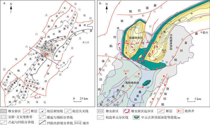
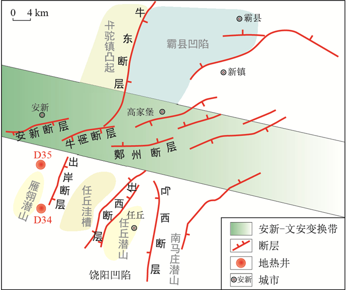
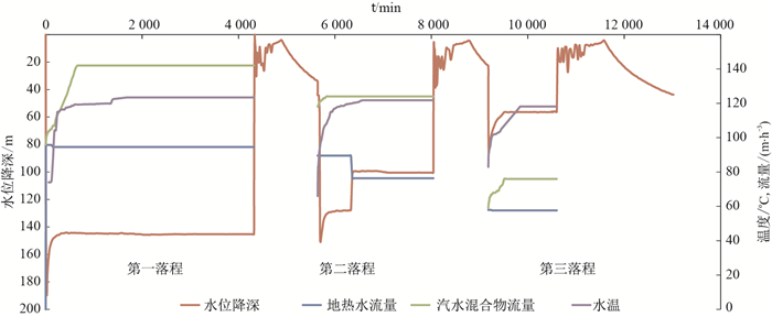
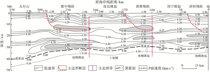
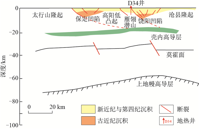
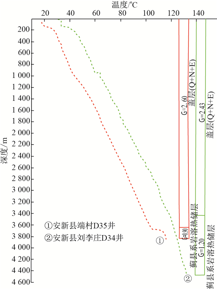
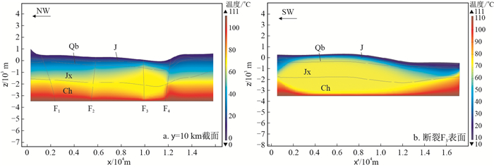
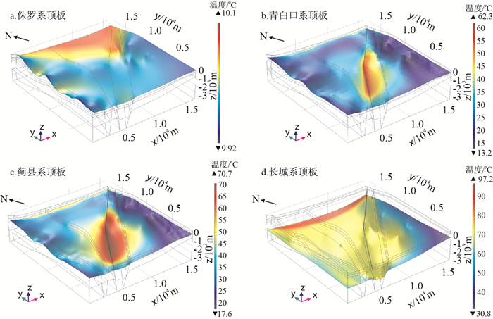
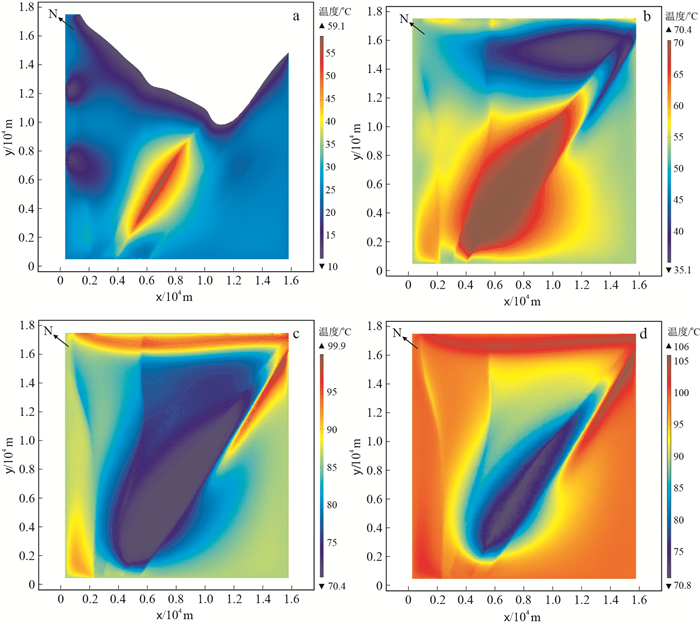
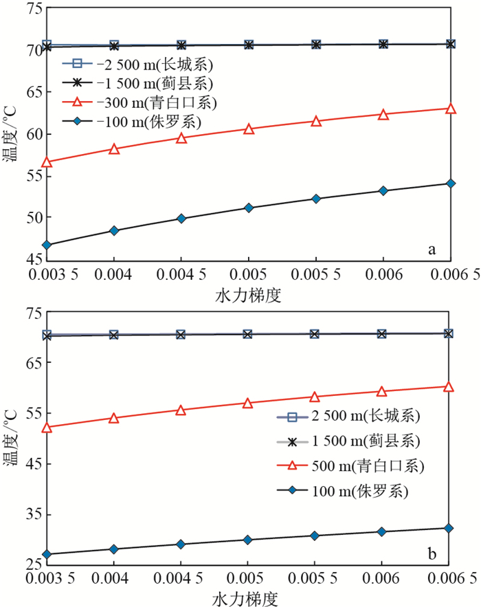
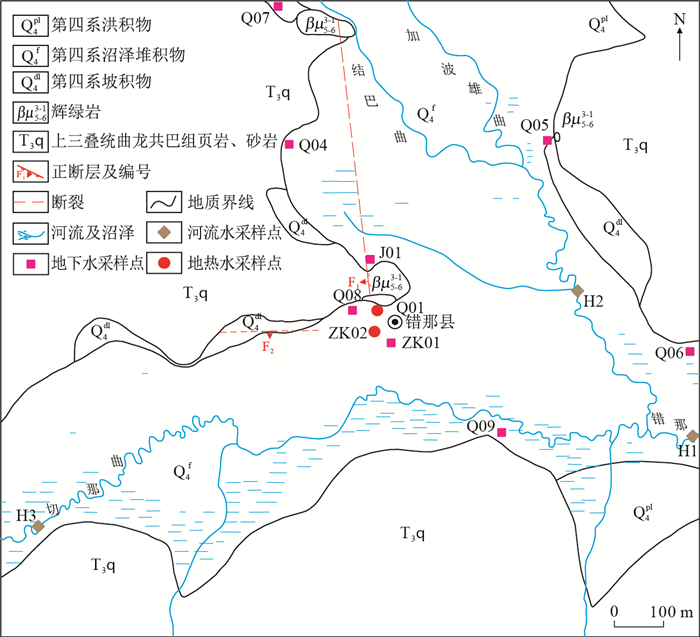
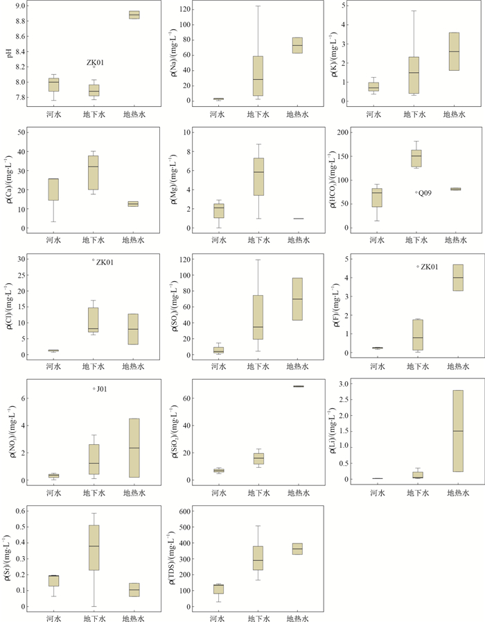
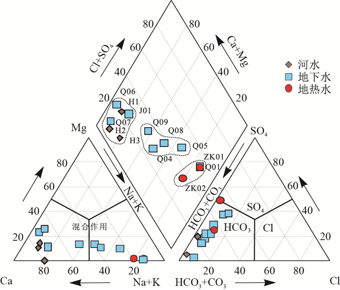
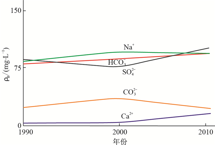
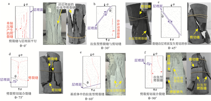
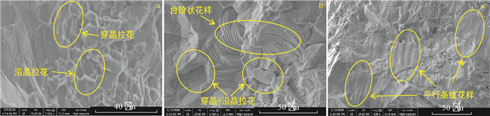
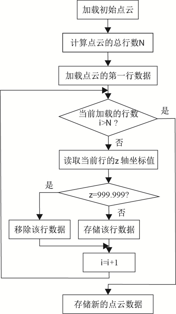
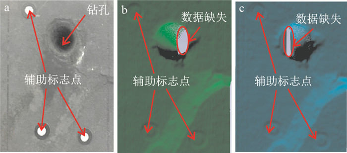
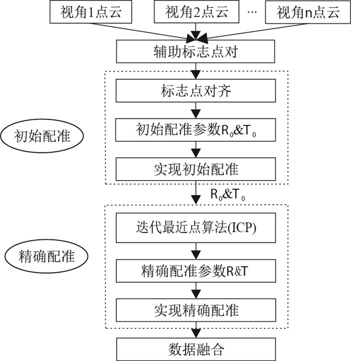
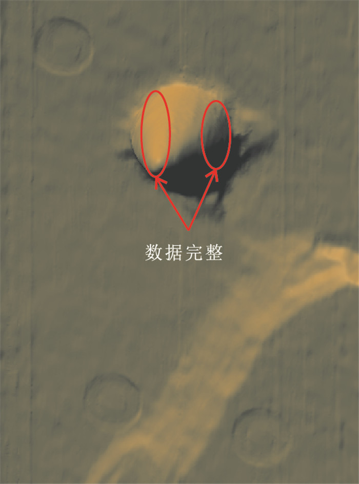
2021 Vol. 40, No. 3

Display Method:
CONTENTS
2021, 40(3)
Abstract:
Evaluation indexes and formation conditions of hot dry rock exploration
Liu Demin, Zhang Changsheng, Sun Minghang, Wei Meihua, Guan Junpeng, Kang Zhiqiang, Xiong Aimin, Zhou Tianyu
2021, 40(3): 1-11. doi: 10.19509/j.cnki.dzkq.2021.0316
Abstract:
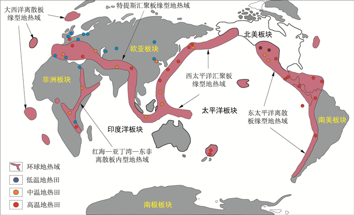
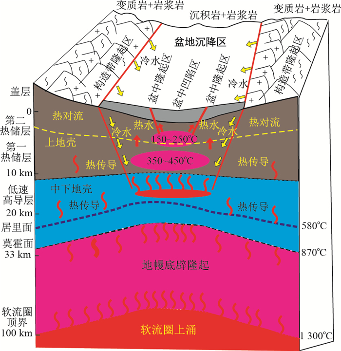
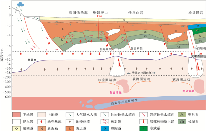
Hot Dry Rock has the characteristics of high utilization rate, pollution-free, huge reserves, wide distribution, sustained stability, good security, and so on. It is recognized globally as a new type of high-quality, renewable and clean energy that can replace fossil energy in the 21st century. At present, the genetic mechanism of Hot Dry Rock has not yet been concluded, and different opinions emerge on the exploration and search of Hot Dry Rock, the delineation of the prospective area, and the evaluation of resources. To facilitate the exploration and development of Hot Dry Rock, this paper summarizes the evaluation indexes of Hot Dry Rock exploration based on previous researches. Several important indexes and their characteristics are described as follows.The first index is the thickness of the Lithosphere and the depth of the Moho. The thickness of the Lithosphere is small and the depth of the Moho is shallow, which is an important index to evaluate the Hot Dry Rock prospect. The shallow buried depth of the Moho indicates that the deep heat source (mantle heat) is closer to the surface, so the shallow buried depth (thin thickness) and uplifting feature are conducive to the upward conduction of deep heat and provide advantageous conditions for the thermal environment of Hot Dry Rock. The second index is the Curie isotherm surface. The shallower buried Curie isotherm surface is an important evaluation index for the Hot Dry Rock prospective area. The Curie isotherm surface is a very special temperature (thermal material) interface inside the earth. It can not only reflect the distribution characteristics of the underground temperature field, but also the heat energy in the deep crust, which is of great significance to the study of Hot Dry Rock and earthquake genesis. If the Curie isotherm surface is buried shallowly, the distance of heat conduction to the surface is relatively short. The deep heat flow is easier to transfer to the surface, which is not only a favorable environment for heat generation of high-temperature Hot Dry Rock thermal environment, but also conducive to the rapid upward conduction of stored heat. The third index is geothermal gradient. A larger geothermal gradient is an important index to hunt Hot Dry Rock prospect. If an area has a high geothermal gradient (≥35℃/km), so the deep geothermal temperature will increase faster as the depth increases. A higher temperature rock mass can be obtained in a relatively shallow place. The fourth index is terrestrial heat flow. A large value of terrestrial heat flow (≥ 75mW/m2) indicates the possibility of a high-temperature rock body in the deep part of the earth. Terrestrial heat flow is a comprehensive thermal parameter of the geothermal field, which can accurately reflect the characteristics of the regional geothermal field. The fifth index is neotectonic movement, which is also an important index while people tend to ignore when searching for Hot Dry Rock. Neotectonics include volcanoes, earthquakes, and active faults. Earthquakes and volcanoes are extremely destructive natural disasters. The occurrence of both exhibits that the heat energy inside the earth has accumulated to a certain extent, thus breaks the earth's internal equilibrium and releases the heat in the form of earthquakes or volcanoes. Among the indicators, the earthquake with the characteristics of large magnitude (> 3 m), shallow focal depth (10-15 km), and the volcanic with the characteristics of high frequency, new activity time (such as active volcano, dormant volcano, and dead volcano since Miocene) mostly indicate an unstable state of high heat in the deep part of the earth, where is easy to form Hot Dry Rock. If we can find the Hot Dry Rock in this area in advance, we can utilize the heat first, then earthquakes and volcanoes may not occur, which can achieve the goal of heat extraction, disaster reduction, and emission reduction. Active deep faults can not only generate part of the heat, but also transfer the deep heat to the shallow parts. Especially the highly active strike-slip tensile faults, featuring ductile shear characteristics in the deep part directly forecast the existence of a high-temperature body in the deep Earth. The sixth index is high-temperature hot springs and gas fields. The formation of hot springs and gas fields is usually closely related to the deep thermal reservoir. It is generally believed that the groundwater penetrates downward along a certain channel, contacts the deep high-temperature thermal reservoir, and then flows out of the surface along a certain channel to form hot springs. Therefore, the exposure of hot springs indicates that high-temperature rocks (Hot Dry Rocks) exist in the deep. It is expected that Hot Dry Rock can be found in the field with the characteristics of abnormally regional geothermal, intensive hot springs, and other high-temperature hydrothermal geothermal fields, which is also a convent method of finding dry heat by hydrothermal heat.As a solid mineral resource, the formation of Hot Dry Rock in deep Earth has four necessary conditions: Source, Transportation, Storage, and Cap. The first condition is abundant dynamic heat sources, such as the deep mantle (mantle-derived heat), the heat-controlled tectonic system-an active ductile shear zone that is active in Late Cenozoic, and the low-velocity and low-resistance body in the crust (middle-lower crust heat), and high-radioactive Mesozoic-Cenozoic granite body (crust-derived heat). The second condition is a quality heat conduction channel, such as the low-velocity layer of 15-25 km in the crust. The low-velocity layer is not only a heat source but also access conducting the thermal energy of deep mantle upwards. The active deep faults (ductile in deep and brittle in shallow) also conduct heat excellently when the asthenospheric mantle uplifts. The brittle faults at the shallow level of the crust are not the heat channel of Hot Dry Rock, while they can transport water and release heat for hydrothermal geothermal energy utilization. The third condition is a huge thermal storage rock body with moderate burial depth (3-6 km), high temperature (≥150℃), large scale(containing rich thermal energy), which has high thermal conductivity (>2 W/mK) and few fractures (containing no water or a small amount of immobile water). Moreover, the thermal reservoir can be metamorphic rock, magmatic rock, or sedimentary rock. The fourth necessary condition is a favorable thermal insulation cover layer, which has the characteristics of low thermal conductivity (< 2 W/mK), moderate thickness (>1 km) (good heat preservation effect), high geothermal gradient (≥40 ℃/ km) and high geothermal flow (≥70 mW/m2) (indicating high-temperature characteristics in the deep) the existence of high-temperature geothermal resources.
Heat accumulation mechanism of deep ancient buried hill in the northeast of Gaoyang geothermal field, Xiong'an New Area
Wang Siqi, Zhang Baojian, Li Yanyan, Xing Yifei, Yuan Wenzhen, Li Jun, Gao Jun, Zhao Tian
2021, 40(3): 12-21. doi: 10.19509/j.cnki.dzkq.2021.0319
Abstract:
There are two high-temperature and high-yield geothermal wells, located in the deep ancient buried hill northeast of the Gaoyang geothermal field at the Xiong'an New Area, are constructed by China Geological Survey during the past two years. The successful implementation of the two deep wells reveal that there is a second space for geothermal development in deep Xiong'an New Area. The deep carbonate rock has a high thermal storage temperature, large flow rate, and huge development potential. On the basis of previous studies, this article fully summarizes the latest survey results of geothermal resources in deep buried hills in the northeast of Gaoyang Geothermal Field and these comprehensive analysis show that the heat accumulation mechanism of the study area are as follows: ① Affected by the westward subduction of the Pacific Plate, the eastern North China Craton is significantly damaged, and the thickness of the lithosphere and crust has been greatly reduced, which is conducive to conduct the mantle-derived heat to the shallow depth; ②The regional Marcy fault and other deep strike-slip faults cut through the lithosphere, which contributed to the deep mantle-derived thermal material and deep magma intruding into the crust; ③The heat flow is gathered from the low thermal conductivity depression to the high thermal conductivity. Besides, groundwater is heated by deep cycle and convection along the fault, and the confluence area of regional karst groundwater also has a certain heat accumulation effect. Because of the combined effect of various favorable factors, a high-temperature and high-productivity carbonate type reservoir is formed in the northeast of the Gaoyang geothermal field.
Numerical simulation of geothermal field in a three-dimensional multi-fractured geological model of Zhuolu Basin
Chen Jinlong, Luo Wenxing, Dou Bin, Zhou Yang, Ning Wentao
2021, 40(3): 22-33. doi: 10.19509/j.cnki.dzkq.2021.0317
Abstract:
The prediction of the geothermal field is an important prerequisite for the evaluation of geothermal resources. Much attention has been paid to the research on coupled temperature field of percolation-heat transfer in deep fractured rock mass. The Zhuolu Basin is a graben-type faulted basin of the Cenozoic era. There are many hot springs on the surface and rich geothermal resources. In this paper, a three-dimensional non-parallel multi-fractured geological model of the Zhuolu Basin for large scale was established based on the actual geological survey results and the geological structure section interpreted by 3 geophysical survey lines. Parameters have been assigned or adjusted, a mathematical model of permeate-heat transfer in multi-fractured rock mass considering groundwater flow was obtained. After the model was verified, the internal temperature field of the basin was calculated and indicated. The geothermal anomaly area is concentrated in the center of the Jixian group (around 70℃) and the north- eastern part of the Changcheng group (90~98℃), the internal temperature field of basin have been analyzed at different hydraulic reaolients. The study results provide a certain basis for the exploration, evaluation, development and utilization of geothermal resources in Zhuolu Basin or similar areas.
Characteristics and source mechanism of geothermal field in Cuona, Tibet
Yu Haowen, Liu Zhao, Rong Feng, Chen Kang, Nan Dawa, Liu Shijuan, Liu Shaoyun
2021, 40(3): 34-44. doi: 10.19509/j.cnki.dzkq.2021.0318
Abstract:
Cuona county is located in the south of shannan region of Tibet and the middle of the Himalayas, which is an important border port in China. To study the characteristics and source mechanism of geothermal field in Cuona, we use hydrochemical meathods such as piper and Gibbs to analyze the hydrogeochemical characteristics and main material sources of the hot springs water with geothermal geological conditions. The temperature of reservoir in the research area is calculated by geothermometers and graphic method of multi-mineral balance after a detailed introduction of the principles of several methods.The comprehensive analysis results indicate that the geothermal reservoir temperature is about 117℃ and the study area is of HCO3-Na type. The next step is to evaluate the resources. The research work we have done can identify main material sources and resources, provide technical support for the development and utilization of geothermal resources, meanwhile, promote ecological environmental protection and change energy structure in this region.
Research progress of fluid-granite interaction in CO2 based enhanced geothermal system
Xue Hui, Shu Biao, Chen Keping, Lu Wei, Zhang Sen, Hu Yongpeng
2021, 40(3): 45-53. doi: 10.19509/j.cnki.dzkq.2021.0021
Abstract:
Compared with water, CO2 has larger expansibility, lower viscosity and lower reaction degree with rock.As an enhanced geothermal system (EGS) seepage heat transfer fluid, CO2 has higher heat transfer efficiency than water.This paper summarizes the research status of fluid/rock interaction in CO2-EGS from three aspects: theoretical research, experimental research and numerical simulation.The changes of reservoir rock properties are evaluated from mineral composition, micro pore structure and mechanical properties.The results show that the main reaction minerals of CO2-water-rock interaction are quartz and feldspar, and the precipitation minerals are montmorillonite, illite and calcite.The interaction of CO2-water-rock will lead to the decline of mechanical properties of reservoir rocks and the change of pore structure characteristics.Finally, the existing problems and development trend of CO2-water-rock interaction in CO2-EGS are discussed, which provides a reference for the development and research of CO2-EGS in the future.
Integrated sedimentary forward modeling and multipoint geostatistics in braided river delta simulation: A case from block T of Tahe Oilfield
He Tingting, Tan Xin, Duan Taizhong, Zhao Lei, Zhang Wenbiao, Qiao Yong, Liu Yanfeng
2021, 40(3): 54-66. doi: 10.19509/j.cnki.dzkq.2021.0301
Abstract:
In order to effectively improve the accuracy of delta sedimentary facies simulation, based on integrated analysis of seismic, core and logging data of Tahe Block T to quantitatively evaluate the complex relationship between recommendation, source supply and transportation, multi-condition constraint is used to create the sedimentary forward model of braided delta sandbody as the 3D training image of multipoint geostatistical simulation.The study shows that the sand body distribution in the braided river delta is affected by the control parameters of sedimentary forward modeling, and the percentage of sandstone supply, the ratio of sediment flow, the discharge and the flood interval are all strong sensitivity parameters, which have a great influence on the distribution of delta sand bodies in the study area; The sandstone content model embodies the retrogradation sedimentary process of the braided river delta, and conforms to the sedimentary characteristics of the study area.Then it is converted to 3D training image, and the multipoint simulation result is characterized by the training image constraints in the three-dimensional space, revealing the facies contact relationship reflected by the training image, and consistent with the drilling knowledge.This study proposes a new method for acquiring 3D training images, which combines the advantages of sedimentary forward modeling and multipoint geostatistical simulation, and has achieved certain application effect, which has a certain reference for the similar 3D geological modeling of sediments.
Micro scopic heterogeneity and mechanical anisotropy of the laminated shale in Longmaxi Formation
Xie Jingyu, Lu Hongzhi, Chen Lei, Jin Xianpeng, Wang Dan, Fu Guoqiang
2021, 40(3): 67-77. doi: 10.19509/j.cnki.dzkq.2021.0302
Abstract:
As a clean energy, the commercial development and utilization of shale gas affect the global energy landscape. The microscopic heterogeneity and mechanical anisotropy of laminated shale have crucial significance for studying wellbore stability and the hydraulic fracture (HF) geometry. In order to provide experimental and theoretical bases for the optimization of drilling and fracturing parameters in the field, the microscopic heterogeneity and mechanical anisotropy of Longmaxi laminated shale were studied. The uniaxial compressive experiments, field-emission scanning electron microscope (FE-SEM) and atomic force microscope (AFM) observations and wave velocity tests were conducted on shale samples cored at different angles. Moreover, the effect of microscopic heterogeneity and mechanical anisotropy on the geometry of HFs was discussed. The results suggest that the bedding planes influence microscopic heterogeneity and mechanical anisotropy in the Longmaxi laminated shales. For the microscopic heterogeneity, with increasing angle between observation direction and bedding planes, the development degree of micropores increased. As observed from FE-SEM and AFM images, the distribution of mineralogical components and organic matter-hosted pores shows strong heterogeneity in microscopic scale, indicative of increasing gas storage capacity (Fig. 1, 2). FE-SEM images of shale samples with different coring angles (β is the angle between the observation direction and bedding direction in the FE-SEM images. The figures show that in the direction parallel to the beddings, the shale matrix is cemented well. With increasing bedding angle, the development degree of micro pore structure increases gradually) AFM images of shale samples with different coring angles (γ is the angle between the observation direction and the bedding direction in the AFM tests. The results are similar to the FE-SEM tests) As for the mechanical anisotropy, under the uniaxial compression, the failure mode and mechanical parameters were different due to the different bedding angles. With increasing angle (θ) between the loading direction and bedding direction, the failure mode gradually changed from tensile failure perpendicular to the bedding planes, to shear failure, and then to the "splitting-shearing" mixed failure (Fig. 3). With increasing θ, the uniaxial compressive strength and Poisson's ratio of Longmaxi laminated shales display a "U-shaped" anisotropic model that is characterized by a first decrease and a subsequent increase. While the elastic modulus and S-P wave velocity shows a decreasing trend, the bedding planes of shale with weak cementation will be damaged before the rock matrix, which will significantly affect mechanical properties of the whole rock. The microscopic heterogeneity of shales influences the anisotropy of mechanical properties to a certain extent. The varying development degree of micropore structure in different bedding directions will indirectly affect the mechanical properties by affecting the strain and cementation degree of matrix during the uniaxial compression experiments. Typical failure patterns and fracture geometry of shale samples with different coring angles Effect of shale anisotropy on the initiation of hydraulic fracture (a.The HF propagates along the bedding plane near the well after initiation; b.The HF propagates directly to the sample boundary after initiation) The microscopic heterogeneity and mechanical anisotropy of shales can affect the HF behavior during hydraulic fracturing, and the fluid seepage flow paths under the shutoff of pumps. The development of natural fracture planes near the wellbore will induce HF propagation. It is suggested that micro-fractures are relatively developed in the direction perpendicular to beddings. The developed micro-fractures not only create conditions for the initiation of HFs, but also provide channels for the seepage of fracturing fluid after the pump is stopped. The results provide theoretical basis for the parameter optimization of laminated shale hydraulic fracturing.
Classification and modeling of targeted fracture-cave bodies in acid fracturing
Song Zhifeng, Zhang Jianguang
2021, 40(3): 78-84. doi: 10.19509/j.cnki.dzkq.2021.0303
Abstract:
targeted acid-fracturing technology is very demanding of the Localization and characterization of the reservoirs near wellbores.It is the key to accurately and quantitatively characterize the location, distance, scale and spatial distribution of the main stress of the reservoir near the wellbore.We realized the integration of the different types reservoir and builded multiple types fusion model of fracture-vug reservoir using five kinds of methods to depict different reservoir type with one-dimensional data to 3d data.Based on the unit level model, a visualized 3d quantitative model method for different ranges of Wells is established, and a three-level single well quantitative model is established.Based on the nine-factor of four-level classification index system of acidizing fracturing, 11 types of target reservoir and its adaptation technology methods were determined.Targeted acid-fracturing oil field application results: the effect is remarkable with higher production, more than 3.6 times than a conventional acid-fracturing in the same oil block.It significantly improves the pertinence and targeting of acid-fracturing technology.
Diagenetic effect of mantle-derived CO2 charge to clay minerals in the Baiyun-Liwan deepwater area of the Pearl River Mouth Basin in South China Sea
Liu Yanhua, Chen Honghan, Wang Yanfei, Han Jinyang, Li Qian
2021, 40(3): 85-95. doi: 10.19509/j.cnki.dzkq.2021.0020
Abstract:
During petroleum exploration in the Baiyun-Liwan deep-water area of the Pearl River Mouth Basin (PRMB), South China Sea, a huge number of CO2 gas reservoirs has been met. Therefore, how to avoid the high CO2 risk has become a big challenge now. In this paper, the X-Ray diffraction (XRD) of clay minerals in the sandstone filled with CO2, microthermometry of fluid inclusions and isotopes of noble gas were used for analysis. The results show that the origin of inorganic CO2 is magmatic. The effects of mantle-derived CO2 on clay minerals are the inversion of clay mineral order degree and the formation of a largeamount of authigenic kaolinite. Moreover, the clay mineral assemblage was divided into three types based on the of XRD analysis data in CO2 wells. Finally, two patterns of CO2 migration and accumulation in the Zhujiang and Zhuhai Formations were summarized: (1) the mantle-derived CO2 migrates vertically upward through the deep faults which connected with the mafic igneous rocks, and (2) lateral long-distance migration through connecting sand bodies after vertical upward migration. These results have certain guiding significance for avoiding the risk of high CO2 in the future exploration in the deep-water area of PRMB, South China Sea.
Application of seismic sedimentology in reservoir prediction in fluvial to shallow water delta facies: A case study in Guantao Formation from the Penglai A structure area in Bohai Bay
Fu Xin, Du Xiaofeng, Guan Dayong, Li Jin, Li Xiaohui
2021, 40(3): 96-108. doi: 10.19509/j.cnki.dzkq.2021.0304
Abstract:
The Penglai A structure area in the Miaoxinan uplift had good drilling show of oil and gas in the Guantao formation, but reservoir sands with the thickness less than 5 meters could not be resolved and interpreted precisely.Recognition that the source direction in the sedimentary period of Guantao formation is northeast, fluvial to shallow water delta facies were developed which was made by comprehensive utilization of drilling cores, the data of sporopollen and algae, logging and 3-D seismic data.90°phasing adjusted seismic wavelet phase to -90°to tie seismic events to lithology.Frequency division was used to interpret, treat and judge phase axis following relative geologic time surfaces to establish high-frequency, sequence stratigraphic framework and optimized 60 Hz dominant frequency seismic data for stratal slicing.Stratal slicing made from the 3-D seismic volume revealed better facies information on the relative geologic time surfaces.With the interpretation of sand body depositional features displayed on each sequence stratal slice, it could be found that sedimentary evolution process in the study area was divided into four stages: fluvial facies stage, sheet-like shallow water delta stage, lobate shallow water delta stage and distributary channel shallow water delta stage.And it also could be found that the sand body mainly developed horizontally in the north of the study area, and the position of fluvial channels and shallow water delta front provided good areas for oil and gas exploration.This study case proved that the method of seismic sedimentology is suitable for thin sandstone reservoir prediction in Bohai basin.
Genesis and geodynamic background of the ore-bearing granodiotite porphyry of the Jilongshan copper-gold deposit in Jiurui district, Hubei Province
Zhan Xiaofei, Wei Junhao
2021, 40(3): 109-123. doi: 10.19509/j.cnki.dzkq.2021.0023
Abstract:
Jilongshan copper-gold deposit is located in the Jiurui metallogenic district in the middle and lower Yangtze River metallogenic belt. Cu-Au mineralization of Jilongshan deposit is closely related to granodiotite porphyry. The petrogenesis of the rock is still controversially discussed. In this study, we report the U-Pb zircon chronology, major and trace geochemistry, Sr-Nd-Hf isotopic compositions of the ore-related granodiorite porphyry in Jilongshan. LA-ICP-MS zircon U-Pb geochronology of Jilongshan granodiorite porphyry is 140±1 Ma(MSWD=1.02). Geochemical results show that Jilongshan granodiorite porphyry has a relatively high content of SiO2 (62.33%~63.90%) and Al2O3 (15.24%~15.74%), and alkalis(w(K2O + Na2O) is 6.99%-7.73%). The trace elements are characterized by the relative enrichment of Rb, Ba, K, Sr, depletion of Ta, Nb. The REE characteristics show rightist features with relatively LREE enrichment with (La/Yb)N ratio of 10.55~15.95, and no obvious negative Eu anomaly. The ziron Hf isotope analysis shows low εHf (t) values, and low εNd (t) (-8.2~-9.7). These data suggested that the Jilongshan granodiorite porphyry may be derived from partial melting of enriched lithospheric mantle, mixed with ancient crustal material to a certain extent.
Water mobility of the main coal seam and its control of porosity and permeability in Jixi Basin
Zhou Wenyu, Wang Xiaoming, Zeng Fangui, Dang Zheng, Zhu Chong, Chen Wenwen, Wang Zhizhuang, Tu Mingkai
2021, 40(3): 124-131. doi: 10.19509/j.cnki.dzkq.2021.0305
Abstract:
Water mobility is an important factor affecting the production of coalbed methane. It is of great significance to analyze the effect of porosity and permeability on water mobility for the development of coalbed methane in Jixi Basin. In order to analyze the influence of porosity and permeability of coal reservoir on the water mobility, we performed low field NMR, permeability and water saturation experiments on the main coal seams of different mining areas in Jixi Basin.The results show that: ①Adsorption pores are relatively developed and the average proportion is 58.36%, while the seepage pores and fractures are similarly developed, with the average proportion of 21.23% and 20.41%, respectively.The seepage pores and fracture are well connected; ②The centrifugal force that makes the studied coal seam reach the bound water state is 1.38 MPa, under which the movable water can be discharged from half-open or open pores with a radius of more than 0.1 μm.By which the movable water saturation is 27.84%-60.87%, with an average of 37.86%; the irreducible water saturation is higher which is calculated as 39.13%-72.16%(av.62.14%).With the increase of pressure, the movable water flows first along the fracture, and then flows out through the seepage pores, while the irreducible water mainly existing in the adsorption pores is difficult to flow because of the large capillary resistance during centrifugation; ③There are obvious differences in water mobility and occurrence in coal samples with similar metamorphic degree, which may be one of the reasons for the difference of water and gas production in different block's CBM wells; ④The movable water in the study area is easy to flow out from coals with higher movable water saturation, greater permeability and more developed pore throat of more than 1 000 nm, but the water is difficult to flow out from coals with lower movable water saturation and more developed pore throat of 0-100 nm in which water is trapped.
Experimental study on the effect of temperature and pressure on CH4 breakthrough pressure in unsaturated low-permeability sandstone
Zhao Shiyu, Li Yi, Ming Liang, Zhang Yong, Li Xufeng, Zheng Changyuan
2021, 40(3): 132-139. doi: 10.19509/j.cnki.dzkq.2021.0306
Abstract:
Breakthrough pressure plays an important role in gas reservoir exploitation and caprock sealing evaluation.In order to simulate the effects of temperature and pressure on CH4 breakthrough pressure in low-permeability sandstones, a step-by-step method was used to conduct CH4 breakthrough experiments on an unsaturated low-permeability sandstone from the Ordos Basin under different combinations of temperature and pressure.The results show that with the increase of temperature or pressure, the breakthrough pressure and time of CH4 show a downward trend, and the pressure change has a more significant impact on the breakthrough process of CH4.It was found that the effect of temperature and pressure on the breakthrough pressure of CH4 is due to the change of interfacial tension and contact angle, and then controls the breakthrough pressure.In addition, it was found that the breakthrough pressure decreases with the increase of the two-phase viscosity ratio; the higher the temperature and pressure, the smaller the breakthrough pressure.Therefore, within this P-T range, for the unsaturated low-permeability sandstone reservoir, the higher the temperature and pressure, the more favorable for gas reservoir development; for the unsaturated low-permeability sandstone caprock, the lower the temperature and pressure, the better the sealing property of the cap rock and the safer the caprock.
Carbon and oxygen isotopic characteristics and uranium mineralization significance of the sandstone-type uranium deposit in the Sifangtai Formation at the southern margin of Daqing placanticline in Songliao Basin
Cai Ningning, Zou Niuniu, Fu Yong, Wei Shuaichao, Li Jianguo, Tang Chao, Wei Jialin
2021, 40(3): 140-150. doi: 10.19509/j.cnki.dzkq.2021.0307
Abstract:
To further explore the diagenetic environment, uranium precipitation mechanism and mineralization mechanism of the sandstone type uranium deposit in Sifangtai Formation on the southern margin of Daqing placanticline in Songliao Basin, the systematic research has been by drilling core observation, rock slice, sandstone uranium containing carbonate cement carbon and oxygen isotopic analysis of the sandstone rock types in the study area, the types of carbonate cements, diagenetic stage and systemic research on the carbon and oxygen isotopic been characteristics, The results show that the uraniferous sandstone rock types are feldspar lithic sandstone and lithic feldspar sandstone, carbonate cement being divided into three periods.For the first time and second time, the priority is given to cement, including calcite, ferroan calcite, see very small amounts of iron dolomite.The value of δ13CPDB is -22.45‰--13.65‰, with an average value of -18.00‰.The value of δ18OPDB is -17.56‰--9.46‰, with an average value of -13.52‰, revealing that there are some organic matters involved.The paleosalinity Z value is between 75.98 and 90.97, which is fresh water deposit.The paleotemperature is between 67.31℃ and 94.92℃, and the diagenetic environment is judged to be in the stage A of early-middle diagenesis based on the above rock features, cementite types and diagenesis.The comprehensive analysis shows that the compaction and cementation of the sadnstone during the early diagenesis stage reduce the porosity of the uranium-bearing sandstone and inhibits the migration of oxygen-rich uranium-bearing fluid.As diagenesis and bruial depth increase, higher organic matter maturity in the hot decarboxylate effect, and the compaction of adsorbed water to form acid solution were formed by dissolution of the feldspar, carbonate cement secondary pore, in order to increase sandstone porosity and promote oxygen rich fluid infiltration of uranium migration.Underlying oil and gas with upward dissipation through fracture provide stratum with reducing agent, making uranium be precipitated and enriched large scale at the bottom of Sifangtai Formation.
Quaternary stratigraphic regionalization and comprehensive framework in Nanling and adjacent areas
Shi Yuanrun, Lin Xiao, Xu Yadong, Yu Shuchao, Sun Qingquan
2021, 40(3): 151-162. doi: 10.19509/j.cnki.dzkq.2021.0309
Abstract:
The Quaternary sediments in the Nanling and adjacent areas are dominated by alluvial, eluvium and cave deposits, which have lacked of a unified stratigraphic and chronological framework.Based on the results of field survey and research on profiles, the Quaternary strata of Nanling area has been divided into five stratigraphic minor regions: Yongzhou-Chenzhou, Guilin-Hezhou, Shaoguan-Qingyuan, Ganzhou and Daoxian-Yangshan minor region.Meanwhile, the framework of comprehensive strata determined by the lithostratigraphic sequence, biostratigraphy, chronostratigraphic and climatic data has also been established.The results show that the Quaternary System in Nanling area can be compared with the Nihewan Stage, Zhoukoudian Stage, Sarawusu Stage of Pleistocene Series and the unbuilt stage of Holocene Series in China.Its biostratigraphy is characterized by the Gigantopithecus Fauna of Early Pleistocene and the Homo sapiens such as Maba, Daoxian, Liujiang hominin since the late Middle Pleistocene.The climatic stratigraphy are represented by the glacial-interglacial cycle and the local climatic characters in the background of the East Asian monsoon, which were reconstructed by alpine peat and stalagmites deposited from the late Pleistocene.However, the comparison between alluvial and eluvium remains difficult due to the lack of dating data.There is also no detailed comparison between the biological evolution stages and climatic stages.Therefore, the Quaternary stratigraphic research in Nanling should focus on improving the dating precision and establishing a unified time scale in the future in order to promote the refinement of comprehensive stratigraphy comparison.The comparison between continental sediments and marine strata in the South China Sea should be expanded.And it can be used as the basis of applications in hydrological, environmental and engineering geology in Nanling and adjacent areas.
Failure characteristics and mechanism of biotite monzogranite with different water content under uniaxial compression
Cao Yangbing, Chen Yuhua, Zhang Peng, Huang Zhenping, Zhang Xiangxiang, Chen Yangtao
2021, 40(3): 163-172. doi: 10.19509/j.cnki.dzkq.2021.0308
Abstract:
The deformation and failure characteristics and mechanism of granite under different water content are of great significance to the stability evaluation of this kind of engineering rock mass. The uniaxial compression tests of biotite monzogranite under different water content were carried out to analyze the failure characteristics and stress-strain curve characteristics. The fracture scanning electron microscope test was carried out to analyze the micro morphology characteristics, and study the failure mechanism of granite. The test results show that: biotite monzogranite has obvious strain softening characteristics. With the increase of water content, the length of the microfracture compaction stage increases, while the length of the stable fracture stage and the unstable fracture stage gradually shortens, but the proportion increases, and the fluctuation alternation in the pre-peak stage of the curve intensifies. Compared with dry samples, the uniaxial compressive strength and elasticity modulus of saturated sample decreased by 40.68% and 20.3% respectively. The deformation and failure process can be roughly divided into five stages: quiescent stage, crack initiation stage, crack growth with particle ejection stage, flaky debris peeling with particle ejection stage and caving failure stage. With the increase of water content, the intensity, sound and brittleness of granite failure gradually decrease. In general, the failure mechanism of granite is tension-shear composite failure. When the granite with low water content, the dominant failure mechanism is tensile failure induced by compression; with the increase of water content, the tensile failure decreases and the shear failure increases; and while the granite is in saturation, the dominant failure mechanism is shear failure. The research results can provide theoretical support for the construction of coupling model between biotite monzogranite and water, and have important scientific significance for the stability analysis of engineering rock mass under water-rock coupling environment.
3D reconstruction and visualization for laser drilling hole on rock based on line laser scanning
Guan Donglin, Wen Guojun, Wang Yudan, Tong Zhiwei, Wu Lingling, Luo Yaokun
2021, 40(3): 173-183. doi: 10.19509/j.cnki.dzkq.2021.0310
Abstract:
The laser drilling hole on rock has a complex pattern, characterized with a generally small diameter and high roughness, so it is difficult to measure the parameters by traditional methods.Therefore, in order to precisely detect the drilling hole and expediently study the shape of the hole, a model of the laser drilling hole based on line laser scanning and reserve modeling is proposed.Specifically, to get the 3D coordinate of the drilling hole, which consists of the original point cloud, a line laser scanning stage is designed and the spatial coordinate system is established.Then, point cloud processing, including the valid points removal and point cloud registration, is implemented in MATLAB, and the removal of invalid points is realized by sequential search, also, based on the iterative closest point(ICP) algorithm, the multi-view point cloud registration is divided into two stages: the initial registration and the precise registration.Finally, based on Delaunay triangulation and surface reconstruction, the model reconstruction and 3D visualization of the drilling hole are accomplished, which provides a good matrix for drilling hole measurement.What's more, compared with the results from the model reconstructed, the titration test and cutting method are used to measure the volume and obtain the contour line of the real drilling hole, to evaluate the accuracy of the drilling hole model.The experimental results show that the error between the models reconstructed and the real drilling holes is less than 4%, hence the reconstructed model can meet the requirements of measuring the parameters of the laser drilling hole on the rock, and the method proposed is feasible.Furthermore, this approach belongs to a non-contact and non-destructive detection method accompanied with good repeatability in comparison with existing methods.
Discrete element simulation study on micromechanical characteristics of undisturbed and remolded loess in biaxial test
Jing Xu, Xie Wanli, Shan Shuai
2021, 40(3): 184-193. doi: 10.19509/j.cnki.dzkq.2021.0311
Abstract:
Loess is a special granular material, and its mechanical properties are determined by the microscopic structure of granules. The undisturbed and remolded loess have different mechanical properties due to the difference in structure. In order to solve the basic problem of how the structural properties of loess affect its mechanical characteristics, based on scanning electron microscopy (SEM) to study the macroscopic and microscopic mechanical properties of undisturbed loess and saturated remolded loess under constant strain rate biaxial test, while considering the shape of particles and the possibility of particle breakage. The simulation results show that when the stress is low, the undisturbed loess and the remolded loess force chains are mostly distributed near the large framework particles. With the increase of stress, the undisturbed force chains form a network pattern but still have the main conduction region, while the remolded loess has no obvious major conduction region and presents a uniform mesh. Under the same confining pressure and strain, the number of cracks in the undisturbed loess is lower and they are concentrated in the shear zone. The number of cracks in the remolded loess is more but more uniform.Tension cracks are mostly formed around the clusters of undisturbed loess and remolded loess. Shear cracks are mostly formed inside the clusters of framework particles, and the most obvious is when the clusters of particles are in contact with each other. Using this modeling method can effectively reflect the different internal stress states of undisturbed and remolded loess under the same stress condition due to the difference in internal structure composition. Based on the above research conclusions, a microscopic explanation of the influence of loess structure on the macroscopic strength is given. The research results can provide a certain basis for the prevention and control of geological disasters in the loess area.
Hydrochemical characteristics and fluoride enrichment mechanisms of high-fluoride groundwater in a typical piedmont proluvial fan in Aksu area, Xinjiang, China
Pan Huanying, Zou Changjian, Bi Junbo, Liu Yunde, Huang Liwen
2021, 40(3): 194-203. doi: 10.19509/j.cnki.dzkq.2021.0312
Abstract:
In inland arid regions, high fluoride concentrations are frequently reported in groundwater which is an important source of drinking water. Investigating its distribution, enrichment and controlling factors could provide insights for better understanding the geochemistry of high-fluoride groundwater, and are critical foundation to ensure the safety of water supply in inland arid regions. To delineate the distribution of high-fluoride groundwater, a comprehensive hydrogeochemical investigation has been conducted in a typical piedmont proluvial fan in Aksu area, Xinjiang, China. The relationship between fluoride concentration and various geochemical parameters has been analyzed for identifying the controlling processes of groundwater fluoride enrichment in this region. The results are: ①Fluoride concentrations in groundwater range from 0.8 to 6.1 mg/L, and 83% of the samples exceed the maximum limit of 1.0 mg/L set by the sanitary standards for drinking water (GB 5749-2006). ②The fluoride concentration was found increasing along groundwater flow paths, and low-fluoride groundwater (ρ(F-)≤1.0 mg/L) mainly distributed in recharge areas by the north of National Highway 314 while high-fluoride groundwater (ρ(F-)>1.0 mg/L) mainly occurred in runoff and discharge areas by the south of National Highway 314. ③The groundwater with high and low fluoride concentration is classified as Cl·HCO3-Na type and Cl·SO4-Na type, respectively, indicating the dominant anion of high-fluoride groundwater is biased towards HCO-3. ④The pH range of groundwater is 7.98.9 with an average value of 8.4, demonstrating a weakly alkaline environment. The groundwater F- content is positively correlated with the pH value. Anion exchange between OH- in groundwater and F- on mineral surface might contribute to the enrichment of fluoride, since there is a certain amount of exchangeable F- in black mica, fluorapatite and other minerals in surrounding Upper Pleistocene sediments. ⑤The F- concentration is negatively correlated with the Ca2+ concentration in groundwater. Considering that calcium fluoride (CaF2) is the main fluorine-containing mineral in the nature and the major source of fluoride in groundwater, the negative correlation between ρ(F-) and ρ(Ca2+) indicates the removal of Ca2+ and Mg2+ in high-fluoride groundwater via cation exchange, adsorption and/or carbonate precipitation. The F- content and Mg2+ concentration of groundwater are also in negative correlation and are highly similar to that between ρ(F-) and ρ(Ca2+), which also evidences the removal of Ca2+ and Mg2+. ⑥The chlor-alkalinity index (CAI) are negative for the majority of groundwater samples, and both CAI-1 and CAI-2 are negatively related with ρ(F-), indicating the exchange between Ca2+, Mg2+ and Na+ in high-fluoride groundwater. There is a great positive correlation between F- content and SAR value, and the average SAR value of high-fluoride groundwater (5.71) is much higher than that of low-fluoride groundwater (1.67), which further proves a strong alternation of Ca2+ and Mg2+ with Na+ in the aquifer and this exchange process plays a significant role in fluoride enrichment. ⑦All groundwater samples are undersaturated with respect to fluorite. An obvious positive correlation between the saturation index (SI) of fluorite and the F- content demonstrates that the continuous dissolution of fluorine-containing minerals (mainly fluorite) is the primary contribution to the accumulation of fluoride in groundwater in the study area. In contrast, the calcite is supersaturated in all groundwater samples, which suggests that the precipitation of calcite may promote the dissolution of CaF2, leading to the increase of F- content in groundwater. ⑧ The δ18O value is between -11.20‰ and -10.67‰ with an average value of -10.94‰ in low-fluoride groundwater, and between -11.65‰ and -11.21‰ with an average value of -11.49‰ in high-fluoride groundwater. Low-fluoride groundwater is more enriched with δ18O than high-fluoride groundwater. Furthermore, the groundwater δ18O value is negatively correlated with F- content when ρ(F-)≤3.0 mg/L, while it remains the same when ρ(F-)≥4.8 mg/L. The above pattern suggests that evaporation contributes little to the enrichment of fluoride in groundwater. ⑨The ρ(F-)/ρ(Cl-) ratio in groundwater is positively correlated with ρ(F-), which also evidences that the dissolution of fluorine-containing minerals leads to the enrichment of fluoride in groundwater, rather than the evaporation. In addition, Gibbs diagram shows that all groundwater chemistry are controlled by water-rock interaction, with little influence of evaporation. In conclusion, our results indicates that high fluoride concentrations in groundwater are controlled by fluorite dissolution and anion exchange between OH- in groundwater and F- in minerals, whereas the influence of evaporation is negligible. And the fluorite dissolution is promoted by the Ca2+ depletion due to calcite precipitation and cation exchange between Na+ absorbed on mineral surface and Ca2+ in groundwater.
Pollution characteristics and ecological risk assessment of heavy metals in surface sediments of main lakes in Dongxihu district, Wuhan
Gong Jie, Sun Zitong, Feng Lu, Hu Shenghua, Ao Hongyi, Wu Chenxi
2021, 40(3): 204-210. doi: 10.19509/j.cnki.dzkq.2021.0313
Abstract:
In this work, heavy metals in surface sediments of main lakes in Dongxihu district of Wuhan City were investigated. The results showed that the average concentrations of Zn, Cr, Ni, Cu, Pb, As, Cd and Hg were 108, 103, 45.3, 39.5, 32.3, 15.1, 0.34 and 0.08 mg / kg, respectively. Among them, the pollution level of Jinhu Lake is the most serious. Compared with other lakes in China, the average pollution level of surface sediments in the main lakes of Dongxihu is relatively low. The results of geoaccumulation index method showed that Cd in Dongdahu Lake and Jinhu Lake was in moderate pollution level, while that in Ink Lake and Shangjin Lake was moderate pollution accumulation level. Heavy metals in sediments of other lakes were in light or no pollution level. The potential ecological risk index method showed that the potential risk of heavy metals in the sediments of Jinhu Lake and Dongdahu Lake was at the high ecological risk level, the Ink Lake, Shangjin Lake and Xiayin Lake were at the moderate risk level, and the potential risks of heavy metals in the sediments of other lakes were at the low risk level. Principal component analysis showed that Hg, Cr, Ni, Cu, Zn, CD and Pb might come from industrial and traffic sources, while as might be related to pesticide use.The ecological risk of heavy metals should be considered in the process of endogenous pollution control of Jinhu, Dongdahu, Yinhu, Shangjin and Xiayinhu Lakes.
Thickness prediction of seismic multi-attributes sand based on association rules and random forests
Qu Zhipeng, Wang Fangfang, Zhang Yunyin, Li Xiaochen
2021, 40(3): 211-218. doi: 10.19509/j.cnki.dzkq.2021.0314
Abstract:
Seismic attributes analysis technique is an important tool for sand thickness prediction. Due to the varieties of seismic attributes, the best seismic attributes need to be optimized before the seismic attributes analysis technique is applied to reduce the repeatability and redundancy of the attributes. Therefore, we present an improved random forest regression algorithm combined with associate rules for sand thickness prediction (AR-RFR). Although random forest regression algorithm(RFR) is powerful for the problem characterized for nonlinearity and high dimension in reservoir prediction, it cannot solve attribute reduction problems. The associate rules can find the non-linear relationship among the multi-attributes and can reduce some redundant attributes by means of Chi-squared Test. We apply ordinary RFR, AR-RFR and Neural network regression algorithm combined with associate rules(AR-BP) to a synthetic geological model and a real dataset. The results prove that the selection attributes from associate rules is more efficient than that from random forest. Compared to the drilled wells, AR-RFR has higher precision than RFR and AR-BP. And AR-RFR also can improve the lateral distribution of sand bodies. The method proposed is able to choose efficient seismic attributes and improve prediction of sand thickness.
Comparison and analysis of CryoSat DEM and the several Antarctic DEM
Yue Wenli, Dong Yusen, Abudula-Abudukadier, Cui Jingyue, Zhang Bangzheng
2021, 40(3): 219-227. doi: 10.19509/j.cnki.dzkq.2021.0315
Abstract:
Antarctica is covered by huge snow and ice, and its geological structure is bounded by the Trans-Antarctic Mountains, and is generally divided into the East Antarctic Shield and the West Antarctic Active Zone. Digital elevation model (DEM) is one of the important basic data to study the Antarctic ice sheet change. Obtaining elevation change information through the comparison of multi-period DEM is an important means to analyze the changes in the thickness and material balance of the Antarctic ice sheet. However, the horizontal and vertical errors between different types of DEM affect the accuracy of the analysis results. In this study, the horizontal error first eliminated by registration between DEMs, then elevation difference and standard deviation are calculated between CryoSat DEM and other DEMs, finally the temporal and spatial variation characteristics are evaluated. The results show that in the plane, the horizontal offset between TanDEM_X DEM and CryoSat DEM is the smallest, while that between ICESat DEM and CryoSat DEM is the largest. In the vertical direction, within the gradient range of 0° ~ 1°, the mean elevation difference between CryoSat DEM and TanDEM_X DEM is between 3.5 and 5.5 m, and the standard deviation is less than 18.0 m. The mean elevation difference between CryoSat DEM and Bamber 1km DEM is between -2.5 and +1.0 m, and the standard deviation is less than 24.2 m. The mean elevation difference between CryoSat DEM and ICESat DEM is between -25.0 and -1.0 m, and the standard deviation is less than 47.2 m. The mean elevation difference between CryoSat DEM and RAMPv2 DEM is between 1.3 and 3.2 m, and the standard deviation is less than 45.6 m. It is found that the internal elevation of Antarctic ice sheet increases, but the elevation of southwest ice sheet and southeast ice sheet decreases, and the southwest pole decreases obviously, while the elevation of Antarctic edge area decreases obviously. This study provides an important reference for global change research and Antarctic material balance research.