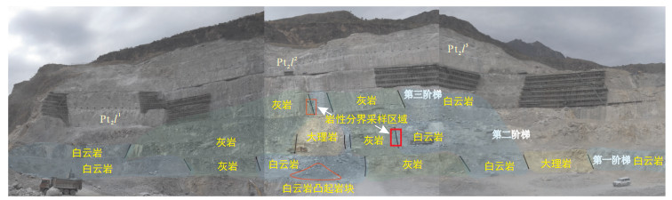
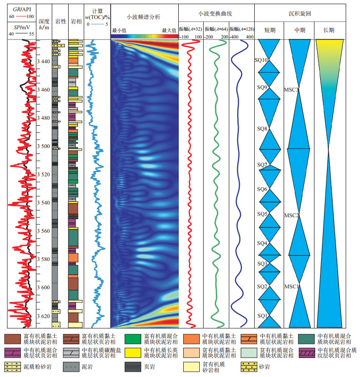
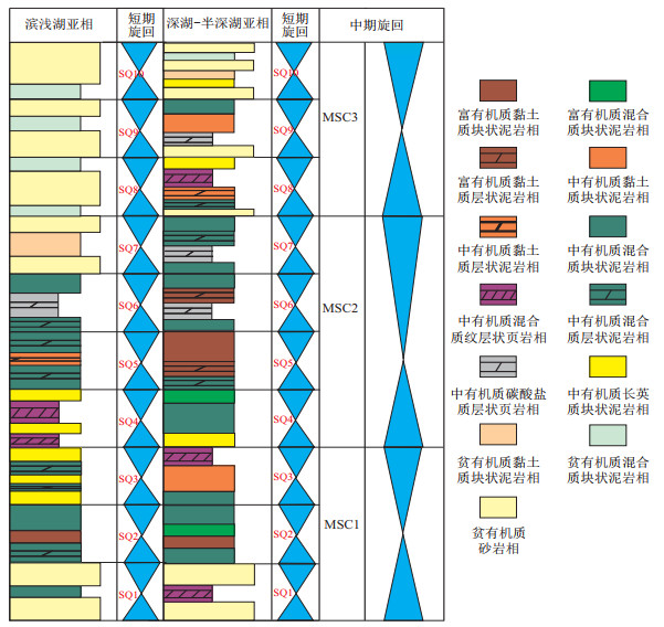
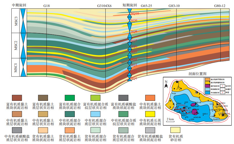
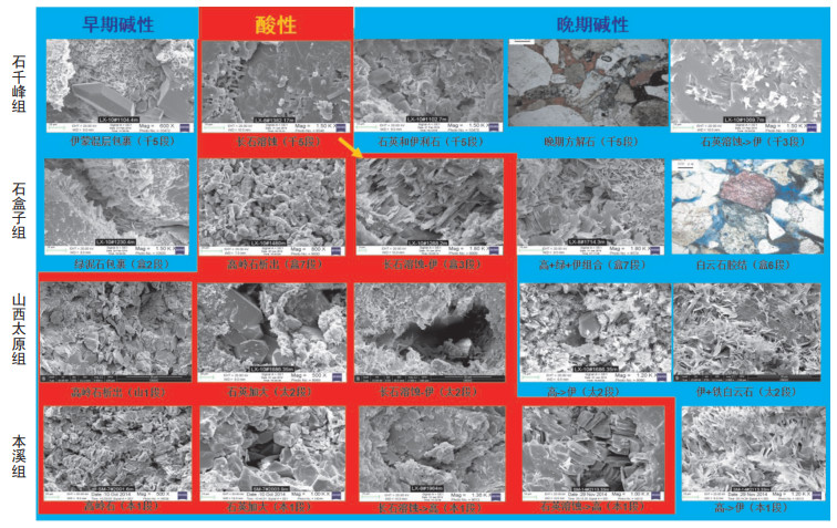
2021 Vol. 40, No. 1

Display Method:
CONTENTS
2021, 40(1)
Abstract PDF icon131 icon5044
Abstract:
Geochemistry and tectonic implication of the sedimentary rocks in Lengjiaxi Group in northeastern Hunan
Bai Daoyuan, Jiang Qisheng, Li Bin, Jiang Wen, Li Yinmin
2021, 40(1): 1-13, 26. doi: 10.19509/j.cnki.dzkq.2021.0017
Abstract:
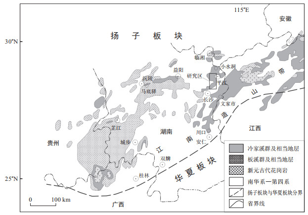
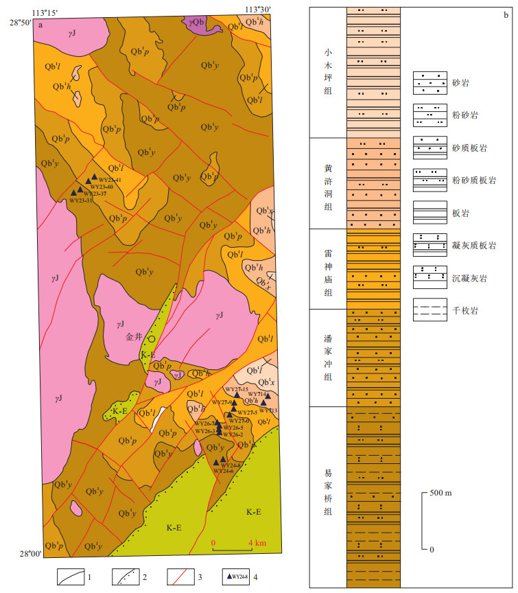
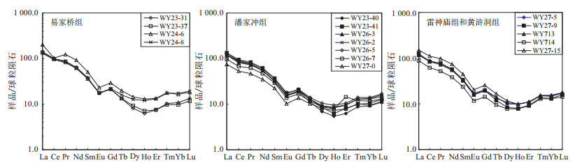
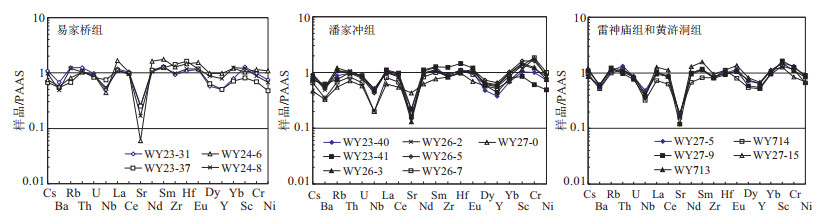
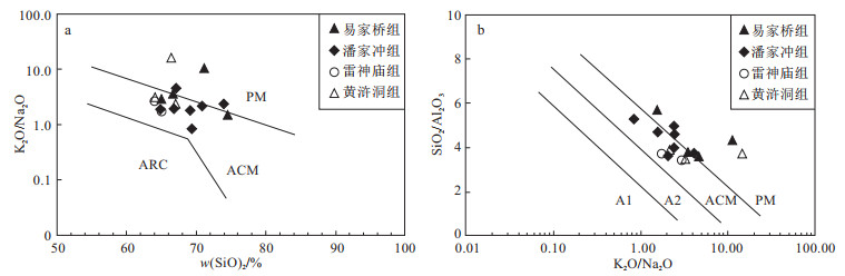
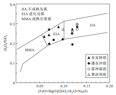
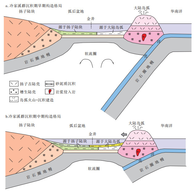
Lengjiaxi Group is the earliest material record of Jiangnan orogenic belt in Hunan.There exist debates about the sedimentary tectonic setting of Lengjiaxi Group and the related location of Qinzhou-Hangzhou juncture.Based on field investigation, the authors collected fresh samples from the sandstones in lower-middle Lengjiaxi Group from Jinjing, northeastern Hunan, analysed their major and trace element compositions, studied the geochemistry of the sandstones in groups by age, and then probed into the basin type and tectonic framework.The sandstones on the whole are characterized by considerable variations of petrochemical components, lower SiO2 contents, high Al2O3 contents, high Al2O3/SiO2 and K2O/Na2O ratios.The REE distribution patterns are similar to typical post-Archean shales and the upper continental crust, with LREE enrichment, flat HREE, and significant negative Eu-anomalies.Characteristics of major elements suggest that the sedimentary environment was back-arc basin, and that the Yijiaqiao Formation and Panjiachong Formation in early stage possess higher maturity with sediment source from stable Yangtze Block to the north, while the Leishenmiao Formation and Huanghudong Formation in middle stage possess lower maturity with more sediment source from active continental arc to the south.Trace element-diagrams for discrimination of structural environment of all the formations show informations of continental arc, which actually reflects back-arc basin setting according to trace element inheritance from source rocks.Relative numeric size of trace elements parameters suggested that the sedimentary environment in the early stage was active continental margin, and in middle stage was continental arc, which is accordant with the information of major elements.According to the geochemistry evidences, the authors put forward the tectonic framework and evolution in Lengjiaxi Period as follows: in the early stage, upwelling of back-arc asthenosphere mantle caused lithospheric to extend for northwest-ward high-angle subduction of Huanan ocean block, and broad back-arc basin was thus formed, when Jinjing area was located in northern basin and there occurred deposits with source mainly from Yangtze Block to the north.In the middle stage, Huanan ocean block subducted with low-angle and pushed the continental arc northwest-ward, which caused the back-arc basin to contract, when for tectonic migration, there occurred deposits in Jinjing area with source mainly from continental arc to the south.Based on the studies of geochemistry of Lengjiaxi Group in this paper and regional geological features, it is considered that the continental arc to the south of back-arc basin was along An'ren-Shuangpai.
Interaction and sedimentary process between the evolution of the bar and bifurcation of the river in the far-source fine-grained braided river: Numerical simulation analysis inspired by modern deposition
Gan Quan
2021, 40(1): 14-26. doi: 10.19509/j.cnki.dzkq.2021.0101
Abstract:
The far-source fine-grained braided river is widely distributed in the middle and lower reaches of the river.The tight oil and gas reservoir formed by the far-source fine-grained braided river is hard for further exploration of potential oil and gas.Combined with the remote sensing image of the modern far-source fine-grained braided river, the growth and evolution process of the far-source fine-grained braided river was modeled by the numerical simulation software Delft3D based on sediment hydrodynamics.The influences of the river discharge and the supply of mud and sand on the morphology of the far-source fine-grained braided river are simulated.The interaction and sedimentary process between the evolution of the bar and the bifurcation of the river in the far-source fine-grained braided river are analyzed and verified.The main findings are as follows:①The widening of the channel along the downstream direction is the main topographic condition that triggers the formation of the far-source fine-grained braided river.The flow velocity and bank firmness are important factors to determine the river width.②The interaction and sedimentary process between the evolution of the bar and bifurcation of the river in the far-source fine-grained braided river are a sedimentary evolution process of the interaction between the sediment of the bar and the flowing water of the river.The interaction between the sediment of the bar and the flowing water of the river includes deposition of sediment in the river and erosion of sediment by the river.③The aggradation of the bar in the river, the separation of the bar and bank, and the river avulsion are the three main forms of the interaction and sedimentary process between the evolution of the bar and the bifurcation of the river in the far-source fine-grained braided river.This paper enriches the theory of sedimentation of the far-source fine-grained braided river.This study is helpful to analyze the spatial distribution of reservoirs in the far-source fine-grained braided river sedimentary facies and to apply it to the in-depth exploration and development of oil and gas.
Evolution and geodynamic background of Myanmar petroliferous basin group
Wang Ying, Xin Renchen
2021, 40(1): 27-35, 48. doi: 10.19509/j.cnki.dzkq.2021.0009
Abstract:
Based on the analysis of the geological records of different tectonic units, and combined with plate reconstruction and geodynamic background, the evolution and their geodynamic background of Myanmar petroliferous basin group are discussed in this paper.The study shows that the basement of Myanmar petroliferous basin group is a metamorphic complex developed in the Late Cimmerian period.From Late Cretaceous to Eocene, the Neo-Tethys oceanic crust subducted towards the NNE under the West Burma block.Accretionary wedge developed on the western edge of the West Burma block, and volcanic arcs, fore-arc rift basins, and back-arc rift basins formed in the West Burma block.Since Oligocene, the Neo-Tethys closed down, and then the Indian block and the northern part of the West Burma block collided, and the basins in the northern part of the West Burma block evolved into back-arc foreland basins.The Indian Ocean crust subducted towards the NEE under the central and southern parts of West Burma block, and the accretionary wedge developed on the western edge of the West Burma block gradually uplifted to the Indo-Burma range.The central and southern basins of the West Burma block on the east side of the Indo-Burma range all evolved into back-arc compressional basins, while the Rakhine basin on the west side of the Indo-Burma range evolved into fore-arc basin.The results of this study have certain indicative significance for the prediction and exploration of oil-gas and mineral resources in the Myanmar basin group.
Hydrothermal dolostones in the Shiqi quarry of Wudongde Hydropower Station, Yunnan
Yu Yongshun, Jiao Liangxuan, Ouyang Guang, Hu Jinwu, Liu Chongping, Zhang Xiong, Wan Liangpeng, Li Guo, She Zhenbing, Wang Tuanle
2021, 40(1): 36-48. doi: 10.19509/j.cnki.dzkq.2021.0010
Abstract:
The Wudongde Hydropower Station in Yunan is the third hydropower station in China with a capacity of over 10 million kilowatts.The artificial aggregate used in its construction is derived from the limestone of the Mesoproterozoic Luoxue Formation of downstream the dam site.However, both limestone and dolostone are found in the aggregate survey and mining yard, meanwhile the lithological boundary between cross cuts the stratum.This paper focuses on the limestone-dolomite transition zone and a dolomite bulge remaining in the aggregate mining yard.Detailed geological survey, petrological work and geochemical analysis have been conducted on the samples of the research area.The results show that: ①Morphological features and spatial relationships of the carbonate minerals suggest that the dolostones are formed by dolomitization of limestone precursors. ②The development of zebra structure, saddle dolomite and associated sulfides and carbonaceous material is consistent with hydrothermal dolomitization. ③Fluid inclusions in the saddle dolomite yield homogenization temperatures between 183 and 215 ℃, which are significantly higher than those of fluid inclusions in the surrounding calcite(102-152 ℃).The dolostones are generally depleted in 18O(δ18O=-13.3‰ to -7.8‰), with the saddle dolomites have the lowest δ18O value(-13.3‰), which is consistent with direct precipitation of dolomite from hydrothermal fluids.The other dolomites, which show lower homogenization temperatures and higher δ18O, are probably related to less influence by the hydrothermal fluids. ④The near-vertical strata and the presence of fractures in the Shiqi area might have provided channels for the migration of hydrothermal fluids, while the overlying dolostones of Sinian Dengying Formation probably have acted as a cap layer, allowing prolonged reactions between the hydrothermal fluids and surrounding limestones.The migration direction of the hydrothermal fluids determines the distribution of the hydrothermal dolostones.
Characteristics and controlling factors of shale reservoir in Wufeng Formation-Longmaxi Formation of the Zheng'an area
Zhang Fu, Huang Yi, Lan Baofeng, Li Long, Liu Ting, Liu Rui, Jiang Dingchuan
2021, 40(1): 49-56. doi: 10.19509/j.cnki.dzkq.2021.0016
Abstract:
The complex tectonic deformation zone in the east of the Sichuan Basin has a great potential of shale-gas resources, but has not been commercially exploited yet.This paper utilizes the mineralogical, organic chemical, and petrologic data of the Wufeng Formation-Longmaxi Formation shale cores, which was deposited in the transition zone of deep-shallow continental shelf and is currently located on the Zheng'an area in the complex tectonic deformation zone, to uncover the characteristics and main controlling factors of gas-shale reservoir in the tectonic deformation zone.The Wufeng Formation-Longmaxi Formation shale samples in the Zheng'an area have a high quartz component, which ranges from 60% to 80% and contributes a high brittleness index.Quartz in the Wufeng Formation-Longmaxi Formation shale is dominant by inorganic origins, including the primary clastic quartz deposition and the secondary quartz from clay diagenesis.The cracking of primary clastic quartz grains or bending of laminated clay under tectonic compaction increases pore space; whereas the filling of secondary quartz into the pore space between mineral grains decreases the bulk porosity.The Wufeng Formation-Longmaxi Formation shale samples in the Zheng'an area have a total organic carbon(TOC) content up to 5.8%, a content of amorphous organic matter more than 80%, and a bitumen reflectance of 2.6%-3.1%.The cracking of organic matter generated number of organic pores, which improved the bulk porosity first and then was compacted and collapsed to be long and narrow polygons.
Pore structure fractal characteristics and its relationship with reservoir properties of the first Member of Lower Shihezi Formation tight sandstone in Hangjinqi area, Ordos Basin
Liu Kai, Shi Wanzhong, Wang Ren, Qin Shuo
2021, 40(1): 57-68. doi: 10.19509/j.cnki.dzkq.2021.0102
Abstract:
Based on physical property, casting thin section, scanning electron microscope, high-pressure mercury injection and other test analysis data, the fractal dimension of pore structure of tight sandstone reservoir was calculated by the method of mercury saturation and water saturation in the first Member of Lower Shihezi Formation in Hangjinqi area, and the relationship between fractal dimension and the physical properties of reservoir was analyzed.The results have shown that the average porosity and permeability of the Lower Shihezi Formation reservoir were 9.83% and 1.03×10⁻³ μm2, respectively.The reservoir space is mainly composed of intergranular dissolved pores, intragronular dissolved pores and residual intergranular pores.The overall fractal dimension calculated by the mercury saturation method is distributed in 2.138 4-2.829 2 with an average value of 2.396 5 while calculated by the water saturation method is distributed in 2.529 4-2.879 7 with an average value of 2.679 1.Compared with the water saturation method, the fractal dimension calculated by the mercury saturation method has a better correlation with the porosity, permeability and pore structure parameters, because the water saturation method tends to produce deviation on samples with smaller pore throat.The pore structure was divided into four types based on fractal dimension: Type Ⅰ(Df≤2.31), Type Ⅱ(2.31 < Df < 2.4), Type Ⅲ(2.4≤Df < 2.52), Ⅳ(Df≥2.52).Fractal dimension(Df), averoged radius of pore throct(Rm) and porosity(φ) were selected to calculate permeability by multiple nonlinear regression.The calculated permeability by multiple nonlinear regression shows strong correlation with measured permeability, whose correlation coefficient squared is more than 0.9, which means the permeability estimation model is suitable for the study area.
Logging identification and prediction of lithofacies of lacustrine shale system in Shichang Sub-Sag, Nanpu Depression
Zeng Bang, Liu Xiaoping, Liu Guoyong, Wang Shaochun, Li Guoyong
2021, 40(1): 69-79. doi: 10.19509/j.cnki.dzkq.2021.0103
Abstract:
The study of the lithofacies of shale formation is the basic work for shale oil exploration.Due to the limited distribution of the continental lacustrine basin and the fast variations of lithofacies, it is difficult to accurately identify and predict the lithofacies.With high precision and good continuity in vertical direction, the logging curve can be used to accurately identify and predict the lithofacies.Based on the experimental data of whole-rock X-ray diffraction(XRD), thin-section identification and geochemical analysis data, the lithofacies can be divided according to the division scheme named three classes & ternary plots.Fitting logging data with TOC value and mineral content, the lithofacies can be comprehensively identified.Finally, the cycle superposition model of lithofacies is established under the high-resolution sequence frame to study the distribution of lithofacies.The results show that the area is a set of oil-bearing lacustrine source rocks with Ⅰ and Ⅱ1 kerogen, which can be divided into 18 types of lithofacies, among which organic-rich argillaceous lamellar shale and organic-rich mixed lamellar shale are the dominant lithofacies.The evaluation indexes of the lithofacies can be calculated and predicted through the logging curve.There is a coupling relationship between the lithofacies and the sequence so that the lithofacies are predictable under the isochronous stratigraphic framework.The lithofacies of shale formation of the Es34 sub-member are under this framework, forming two organic-rich layers located in the middle of MSC1 and MSC2 middle cycles and four sedimentary tectonic development zones corresponding to the SQ5-SQ8 ascending semi-cycling.
Origin and geological significance of ultra-low resistivity in Lower Paleozoic marine shale, South China
Hou Yuguang, Zhang Kunpeng, He Sheng, Qin Weifeng, Xiao Yan, Wang Cheng, Yu Rui
2021, 40(1): 80-89. doi: 10.19509/j.cnki.dzkq.2021.0104
Abstract:
Combining with the data of logging resistivity and organic geochemistry, polarizability test and Laser Raman spectra were used to analysze the main controlling factors of ultra-low resistivity (logging resistivity as low as 10-1 Ω·m and below) in the high evolution marine shale of Lower Paleozoic, southern China.Moreover, its internal cause and geological significance were also discussed in this paper.Results showed:1) The abundance and maturity of organic matter (OM) are the main factors affecting the ultra-low logging resistivity.There is a good negative correlation between TOC, logging resistivity and measured resistivity.Increasing of maturity will lead to the decrease in the minimum TOC threshold required to achieve ultra-low resistivity, and the polarizability of shale also increases.2) Graphitized OM is the main "conductive mineral" that causes ultra-low resistivity in high thermal evolution shales.The RmcRo corresponding to the critical point at which the OM begins to graphitize is about 3.5%.Extremely low resistivity is an important indicator that the structure of shale organic matter changed significantly and evolved to graphite.3) Logging response of the ultra-low resistivity is likely to indicate that the quality of shale reservoir has suffered great damage, such as exhaustion of hydrocarbon generation capacity, severely reduction of OM pores and adsorption capacity, and abruptly decline of gas content.Therefore, delineating the range of extremely low resistivity shale and excluding the high-risk area of "OM graphitization" could play a great significance role in shale gas assessment and target selection in high evolution Lower Paleozoic shale.
In-situ U-Pb dating of pitchblende and the REE characteristics using LA-ICP-MS in Xiangyangping uranium deposit
Li Jie, Huang Hongye, Liu Zijie, Zhang Tao, Cheng Qi, Zou Mingliang
2021, 40(1): 90-99. doi: 10.19509/j.cnki.dzkq.2021.0011
Abstract:
The Xiangyangping uranium deposit is a newly discovered granite-type uranium deposit, which is one of the representative granite-hosted uranium deposits in the Miaoershan uranium ore field.The Xiangyangping uranium deposit has developed a large number of primary pitchblende veins, but the chronology characteristics of uranium minerals are obscure, especially the application of in-situ analysis technique is lacking.In order to further clarify the uranium mineralization age of the uranium deposits, in-situ U-Pb isotopic dating of pitchblende veins exposed in the borehole was studied by using LA-ICP-MS.The U-Pb age dating of the pitchblende obtained ages of 51.59 Ma and 41.10 Ma, suggesting that there are two phases of uranium mineralization in the Xiangyangping area, which are consistent with the main mineralization periods of 65-50 Ma and 45-40 Ma for the Shazijiang uranium deposit.The former is the main metallogenic age of Xiangyangping uranium ore deposit, while the latter is the thermal event time of late fluid activity leading to pitchblende alteration, indicating that there is a major uranium metallogenic event of about 52 Ma in the Miaoershan uranium ore field.The chondrite-normalized patterns of rare earth elements are rich in light-REE, with obvious negative Eu anomalies.The distribution curve of rare earth elements in pitchblende is characterized by in seagull pattern, which is similar to low-high grade uranium ore, and different from the "right-dipping type" of fresh granite and altered granitic cataclastic rock.The migration of REE and pitchblende was synchronous, which is the product of crystallization and precipitation at a low-temperature hydrothermal environment.
Difference analysis of gravity decollement structures and its effect on hydrocarbon accumulation: By comparing analysis of Lower Congo-Congo Fan Basin and Niger Delta Basin
Li Dan, Pang Lin'an, Kang Hongquan, Cao Xiangyang, Liu Xiaolong, Jia Jianzhong, Ma Shaoguang
2021, 40(1): 100-109. doi: 10.19509/j.cnki.dzkq.2021.0105
Abstract:
Gravitational decollement is a structural pattern commonly developed in passive continental marginal basins on both sides of the Atlantic Ocean.Two different types of gravity decollement structures with transitional salt and marine mudstone as decollement layers are developed.Based on the stress mechanism, it can be divided into extensional zone, transitional zone and compressional zone successively from the continent to the ocean.In order to clarify the difference between those two types of gravitational decollement structures and their influence on oil and gas accumulation, this paper makes a comparative analysis of two representative basins, the Lower Congo-Congo Fan Basin and the Niger Delta Basin.Through comparing, the differences of structure patterns, sedimentary reservoir distribution characteristics and hydrocarbon accumulation were clarified in the same zone.On the whole, salt gravitational decollement in extensional zone shows that the salt structures are highly active, the oil-gas accumulation conditions are superior, and there are many oil-gas discoveries in this zone.In transitional zone, the intensity of salt activity is moderate and the degree of oil-gas enrichment is the highest.In compressional zone, the salt activity is strong with a large scale salt accumulation, poor source rock and reservoir, and rare oil-gas discoveries.The extensional zone of marine mudstone gravitational decollement is the main oil-gas accumulation area with relatively weak structure activity and good match between the reservoir and source rock.In transitional zone, it has strong extrusion stress, and large amount of mudstone has been accumulated there.The mud diapir is magnificent, and deep-slow diapir structure is the favorable oil-gas accumulation area.The compressional zone is dominated by typical thrust imbricate structure with good match of source rock, reservoir and oil source faults.The oil-gas enrichment in this zone is relatively high.Based on the analysis of those two types of gravitational decollement in source rock, reservoir and hydrocarbon accumulation, this paper have provided some references for the research related to gravitational decollement.
Sedimentary characteristics and significance in hydrocarbon exploration of sandy debris flow in Meishan Formation of the northern Lingshui Sag, Qiongdongnan Basin
Li Anqi, Ye Qi, Wang Zhenzhen, Li Ming, Chen Kui
2021, 40(1): 110-118. doi: 10.19509/j.cnki.dzkq.2021.0106
Abstract:
Through comprehensive analysis of core description, core slice observation and grain size data, in combination with regional palaeogeomorphology and seismic facies study, the sedimentary structure characteristics and its identification mark of the Meishan Formation sandy debris flow in northern Lingshui Sag of Qiongdongnan Basin were discussed in details.The sedimentary model of sandy debris flow in the study area is then established based on its sedimentary environment and characteristics.Two main lithological associations developed in sandy debris flow sedimentation in the Meishan Formation, which were thick massive bedding siltstone to very fine sandstone without sedimentary structure and silty mudstone, mudstone and siltstone interbeds with abundant contemporaneous deformation structure.These lithological associations formed during the process when the sediments of the delta front and the pre-delta on the shelf went frozen sliding as whole and collapsed and deposited again as sandy debris flow.Their distribution was mainly controlled by the shelf break and roughly distributed parallel to the shelf break showing tongue shaped outline.Combined with regional hydrocarbon accumulation elements study, it was thought the sandy debris flow sandstone in the study area could form lower-generation and upper-reservoir type lithological reservoirs with faults connecting to deep source rock, and this would be an important exploration break through to realize the exploration breakthrough in finding large and medium-sized oil and gas reservoirs in Qiongdongnan Basin.
Quantitative prediction of the undiscovered epithermal gold(silver) mineral resources in Sumatra, Indonesia
Zhao Fengshun, Hua Shan, Wu Hao, Zhang Xiaojun, Yang Senlin, Wei Yiwen
2021, 40(1): 119-131. doi: 10.19509/j.cnki.dzkq.2021.0107
Abstract:
Sumatra Island, located on the western edge of Indonesia, is an important part of the Pacific Rim metallogenic belt, and has abundant mineral resources such as copper, gold(silver) lead and, zinc.The quantitative prediction for these mineral resources can provide basic data for the "Belt and Road" strategic decisions of China.Based on the geologic investigations and the 1:1 000 000 low-density geochemical survey, this paper analyzed the mineralized characteristics, key ore-controlling factors, and prospecting indicators for the epithermal gold(silver) deposits, and established a prediction model for this type of gold(silver) deposit.This model suggested that the NW-trending Sumatra fault and its secondary faults have a close spatial-temporal coupling relationship with Cenozoic arc magmatic rocks, and they jointly control the gold(silver) mineralization in this area.The NW-trending faults, the Cenozoic magma rocks, the distribution of gold(silver) deposits, and the 1:1 000 000 low-density Au-Ag-Cu geochemical anomalies can be used to rapidly delineate the prospecting areas of the epithermal gold(silver) mineralization.Five prospecting areas were delineated according to the prediction model.Furthermore, a general density model was used to predict the number of undiscovered mineral deposits in various prospecting areas under different probabilities, and the probabilistic number of the gold(silver) resources were estimated for the epithermal gold(silver) deposits by the "three-part" quantitative assessment method.
Advances in the application of machine learning methods in mineral prospectivity mapping
Ma Yao, Zhao Jiangnan
2021, 40(1): 132-141. doi: 10.19509/j.cnki.dzkq.2021.0108
Abstract:
This paper reviews the development of mineral prospectivity mapping at home and abroad, and conducts statistical comparative analysis of relevant foreign literature in the past decade.It shows that machine learning methods have become a hot topic in the field of mineral prospectivity mapping, and have played an active role in the following three aspects: ① extraction and mining of hidden and unrecognizable mineralization information in complex data; ② association and transformation of ore-forming anomaly information; ③ fusion, prediction and discovery of ore-forming anomaly information from multi-source geological data.Firstly, the application effects of major machine learning algorithms and models, such as logistic regression, artificial neural networks, random forests, and support vector machines, in mineral prospectivity mapping are reviewed.Secondly, it discusses the main problems in the application process, such as sample selection, misclassification cost, uncertainty evaluation, and model performance evaluation, as well as the current solutions.Finally, it is proposed that quantitative prediction of mineral resources based on big data and machine learning is an important trend in the future.
Features of the acid and alkaline diagenetic environment of tight sandstones and the control of the reservoir physical properties: A case study of the Linxing and Shenfu district, eastern Ordos Basin
Yin Xiangdong, Jiang Shu, Wu Peng, Gao Wei
2021, 40(1): 142-151. doi: 10.19509/j.cnki.dzkq.2021.0109
Abstract:
The pH value of plaeofluid exerts great influence on the formation of the secondary pores of sandstones.In the paper, the control of the acid and alkaline diagenetic fluid environment on the reservoir quality was analyzed in the Upper Paleozoic tight sandstones in the Ordos basin.Based on the plenty of survey of casting thin section, scanning electron microscope, X-ray diffraction, routine testing of physical properties, and high pressure mercury injection, the characteristics of petrology and mineralogy, physical properties, diagenesis, genetic types of pores, and pore-throat structure within the Upper Paleozoic tight sandstones were detailedly investigated in the Linxing and Shenfu district, eastern Ordos Basin.The identification, zonage, and distribution of the acid and alkaline diagenetic environment within tight sandstones as well as the evolution of diagenetic fluid environment and its reponse of the physical properties were investigated.Results showed that the upper strata underwent a diagenetic fluid evolution of alkaline-acid-alkaline mode during the burial process, whereas the lower strata experienced a mode of acid-alkaline.Acid diagenetic environment was characterized by feldspar dissolution, quartz overgrowth, and deposition of authigenic kaolinite, in which feldspar dissolution pores, intercrystalline pores of clay minerals developed with relatively large pore radius and better reservoir quality.Alkaline diagenetic environment was featured by quartz dissolution and deposition of authigenic chlorite, in which quartz dissolution pores and intercrystalline pores of clay minerals developed with relatively small pore radius and poor reservoir quality.The case of transitional zone of acid and alkaline zone(TZAA) falls in between acid zone(AZ) and alkaline zone(AlZ).Nevertheless, the physical properties are best in the AZ, followed by TZAA.The distribution of the AZ, AIZ and TAZZ and their responds to the physical properties are significant to the reservoir evaluation.
Application of SBM-DEA model in comprehensive quantitative evaluation of reservoir
Zhu Zhaoqun, Qu Lili, Li Dan, Lin Chengyan, Wu Fuzhu, Yang Ling, Sun Mingxiang, Ming Hongxia
2021, 40(1): 152-158. doi: 10.19509/j.cnki.dzkq.2021.0110
Abstract:
Aiming at the problems of strong subjectivity, complicated calculation procedures and inadequate analysis in traditional reservoir evaluation, the application of the Slack Based Measure model of Data Envelopment Analysis (SBM-DEA model) in comprehensive quantitative evaluation of reservoir was discussed.It is shown that this model has the following advantages:① It could take into account of both the positive and negative related indicators, and is more objective that there is no need to determine the evaluation criterion and index weights by subjective analysis in advance; ②Taking the linear programming as the tool, it could simplify the calculation procedure that it does not have to standardize the evaluation indexes; ③ The evaluation result is between 0-1 naturally, and it can be not only used for sorting and classification of evaluation units, but also providing the reason that units are not efficient as well as the suggestion on how to improve them.The new method was applied in early low-permeability gas reservoir evaluation on the lower section of the eighth member of Shihezi Formation(Middle Permain) in SuX region of Sulige gasfield.Four types of reservoir are classified in the study area and the type Ⅰ and Ⅱ would be the favorable targets.The new evaluation results obtained generally accorded with the traditional fuzzy comprehensive reservoir evaluation results, and showed good consistence with practical field production and geological knowledge.At the same time, the main advice on insufficiency and improvements for this case was given.It is proved that this evaluation method is reliable and practical in application, and provides new thought for similarly effective and objective reservoir evaluation as well.
Action law of geometrical characteristic parameters in the anti-dip rock slopes under different free face condition
Huang Shaoping, Yan Echuan, Yin Xiaomeng, Chen Qian, Li Xingming
2021, 40(1): 159-165. doi: 10.19509/j.cnki.dzkq.2021.0111
Abstract:
The anti-dumping layered rock slope is a common type of slope, which has various deformation and failure modes, complicated mechanics mechanism and many influencing factors.In order to reveal the influence law of the geometric characteristic parameters in different fronting surface conditions on the flexural toppling deformation of the reversed inclined layered rock slope, this study used 3DEC to research the influence law of geometric characteristic parameters on flexural toppling deformation, combined with mathematical statistics system.The obtained results show that: ① The maximum deformation displacement is found on three faces of the slope and the minimum on one face; ② The deformation displacement of slope increases with slope height, slope angle and joint inclination, and it decreases with the increase of the included angle between the joint surface and the free face; ③ The deformation displacement of the slope is the largest when the angle between the two free faces is 90°; ④ The deformation displacement is the largest when joint inclination angle is 60° on the one and two free faces, and it increases with the joint inclination angle increasing.
Nonlinear solutions of lateral response for piles under axial and lateral load embedded in layered soils
Xing Kangyu, Lu Hongzhi, Chen Yaochun, Wang Xinguo, Zhang Kaishun, Wu Wenbing
2021, 40(1): 166-174. doi: 10.19509/j.cnki.dzkq.2021.0112
Abstract:
Most of the previous studies were based on the linearly elastic or linearly elastic-plastic horizontal load transfer model for the laterally loaded piles undergoing axial load.In order to improve the calculation and design accuracy of axially and laterally loaded piles, considering the P-Δ effect caused by axial force of piles using the axial load transfer method, this paper proposes a nonlinear analysis approach based on hyperbola load transfer model to calculate the lateral response of elevated piles embedded in layered soils.The nonlinear finite difference solutions of the deformation and internal force for the pile shaft are obtained, and the relevant computer program is developed by MATLAB software.The accuracy of the nonlinear solutions is verified by utilizing the model test and the finite element calculation based on the field test.The calculation results showed that the results obtained by the nonlinear approach are in good agreement with the model test and finite element data.Besides, the results calculated by the approaches with different load transfer models are compared under different load levels.The nonlinear characteristics of pile-soil deformation cannot be ignored in calculation of lateral pile responses under large load.
Characterization of the heterogeneity of a fractured aquifer based on hydraulic travel time inversion
Wu Shuanghong, Liu Quan, Qi Junjie, Qiu Pengxiang, Yang Huichen, Tao Ran, Thomas Ptak, Hu Rui
2021, 40(1): 175-183. doi: 10.19509/j.cnki.dzkq.2021.0015
Abstract:
The spatial distribution of aquifer hydraulic parameters is an important and basic factor to study groundwater seepage, groundwater pollutant transport processes and many other groundwater related problems.However, due to the limitation of conventional exploration technology, the spatial heterogeneity of aquifer hydraulic parameters cannot be described accurately and intuitively.Especially for fractured aquifers, the heterogeneity of hydraulic parameters is much stronger.In order to solve this problem, this study attempts to characterize the hydraulic properties of a fractured aquifer by using travel time based hydraulic tomography.Firstly, the head data at 8 different depths (receivers) in the observation well are recorded through 64 multi-level short-term pumping tests at 8 pumping intervals (sources) in the pumping well with help of double packers performed in Goettingen Germany.All these 64 head response data are used to calculate the hydraulic parameters (K and Ss) with Jacobian analytical solution.Subsequently, the derived hydraulic travel times between each source and receiver are utilized to obtain the hydraulic diffusivity distribution based on hydraulic travel time inversion.For the validation, the inversion results are finally compared with the results from Jacobian analytical solution and thermal tracer test.It shows that the estimated parameters of analytical solution indicate the vertical heterogeneity, but it cannot describe the spatial distribution of these parameters between wells.Results of thermal tracer test have proven the plausibility of the travel time based hydraulic tomography for the characterization of the fractured aquifer.
Climate change recorded by the grain size end member since MIS 3 in Jingbian area
Gong Xuejiao, Wang Pan, Yang Zhenjing, Dong Qiuyao, Song Chao, Guo Jiao, Chen Hongyun
2021, 40(1): 184-191. doi: 10.19509/j.cnki.dzkq.2021.0113
Abstract:
As a typical multisource sediment, the grain size distribution of loess presents multi-peak distribution.End member analysis can be used to separate the end member components representing different sediment sources and sedimentary dynamics from the complex sediment size, which has been widely used in loess research.In this paper, Paterson parametric end member model was used to separate and explained the end member size of Sandaogou profile located in the southeastern margin of the Mu Us Desert.The analyzed results indicated that the Sandaogou loess in Jingbian was divided into four end members: EM1(8.93 μm) was the background dust; EM2(25.18 μm) was a component related to monsoon circulation.EM3(39.91 μm) and EM4(56.37 μm) were components related to winter wind.Among them, EM3 was the main component of loess in the loess plateau and EM4 was roughly the same grain size as modern sandstorms.Through the analysis of the curves of the end member components with age, the following conclusions were drawn: the profile recorded that the Jingbian area had experienced MIS 3(32.8-29.8 ka BP), LGM(29.8-22.8 ka BP), last deglacial(22.8-11.3 ka BP) and Holocene(8.7-1.7 ka BP) since MIS 3. Three climatic rapid change evented and cycles Dansgaard-Oeschger in deglaciation Heinrich 1(16.2-13.8 ka BP), Bølling-Allerød(13.8-12.8 ka BP) and Younger Dryas(12.8-11.3 ka BP) were recorded.The profile also recorded three major expansion-contraction cycles during last glacial period of the Mu Us Desert, and three dry sand events during the Holocene(8.7-8.2 ka, 6.0-5.0 ka, and 3.5-2.5 ka).
Analysis of spatial variability and influencing factors of arsenic in groundwater of Hetao Plain, Inner Mongolia
Zhang Haoyue, Liu Wenbo, Zhang Xujiao, Su Chunli
2021, 40(1): 192-199, 208. doi: 10.19509/j.cnki.dzkq.2021.0014
Abstract:
Hetao Plain is one of the most serious area of local arsenic poisoning in China.Based on shallow groundwater arsenic samples, the paper used the semivariogram to reveal the spatial distribution and heterogeneity of groundwater arsenic concentration, and further discussed the influencing factors.The results show that the arsenic concentration in groundwater generally increases from south to north in the Hetao Plain.The residual groundwater arsenic concentration is fitted to the pure nugget effect model under the assumption of isotropic conditions, which means it is random on the measured scale, so there is no spatial autocorrelation and the variance is great in short distances.The fractal dimension value is large(D=1.999), further indicating the distinct variation of groundwater arsenic concentration within the measured scale.Groundwater arsenic is closely related to organic matters in sediments.Since the Late Quaternary, the tectonic movements of the northern mountains and changes in the sedimentary environment of the basin has caused multiple sedimentary facies, resulting in a high degree of spatial variability in burial conditions of organic matters.The high spatial variability of organic matters characteristics further leads to high spatial variability of groundwater arsenic concentration.The slow groundwater flow plays an important role in maintaining this pattern.This article focuses on the spatial heterogeneity of groundwater arsenic in the Hetao area, which has scientific significance for effectively predicting the potential risk of arsenic exposure in drinking water in unknown areas, accurately preventing endemic diseases and ensuring water supply safety.
Factors affecting high temperature rheological properties of polymers used in drilling fluid
Zhu Xuming, Wu Xiaoming, Zheng Wenlong, Mulati Dina, Jiang Ziwei
2021, 40(1): 200-208. doi: 10.19509/j.cnki.dzkq.2021.0115
Abstract:
Polymer has a significant effect on the high temperature rheology of drilling fluid.The effects of polymer type, addition amount, shear time, salt and clay on the HTHP rheological properties were compared and analyzed, and the relationship of shear rate and shear stress was fitted to different rheological models.The increase of temperature, shear time and salt amount all led to the decrease of viscosity, especially when the temperature exceeded 190℃.In the cooling progress, the viscosity recovery rates of polymer solutions containing 5% HCOONa and 5% NaCl are 86.8% and 2.7%, respectively.Bingham model was used to characterize the mixture of polymer and clays, and the maximum yield point was 5.47 Pa at 220℃.Heating increases the tendency of the polymer solution to change from pseudoplastic to Newtonian.Above 130℃, the tendency of viscosity to decrease is obvious duedue to shear time.Meanwhile, the viscosity of the formate-containing polymer salt solution is higher than that of the chlorinated salt, and the viscosity retention rate of the former in the cooling process is also higher.The presence of clay enhances the structure force of the polymer solution, which is helpful for cuttings transportation at high temperatures.
Extraction of iron meteorites from the Barringer Meteor Crater based on remote sensing alteration information
Cui Jingyue, Dong Yusen, Yue Wenli, Abudula-Abudukadier, Zhang Bangzheng
2021, 40(1): 209-216. doi: 10.19509/j.cnki.dzkq.2021.0116
Abstract:
At present, there are more than 190 craters have been confirmed on the earth, and most of the simple impact craters with a diameter of less than 1 km are formed by iron impactor.There is a large amount of iron meteorite material around the impact crater struck by the iron impactor.The spatial distribution characteristics of iron meteorite are of great significance for studying the impact process and mechanism of the crater.The enrichment of iron can also be used as important information to explore suspected impact craters on the Earth's surface.In order to obtain iron meteorite fragments around the impact crater, field investigations were mainly conducted manually in the early days, but this method was inefficient and required a lot of manpower and material resources.Based on the unique spectral characteristics of the meteorite, the spatial distribution characteristics of the meteorite material around the impact crater can be easily obtained by using the remote sensing alteration information extraction method.This paper selects Barringer Meteor Crater in Arizona, USA as the research object, considering of the spectral characteristics of iron meteorite, and using Band Math-PCA(principal components analysis).The extraction results fit well with the field survey of the distribution of iron meteorites by the predecessors.The iron meteorite aggregation area on the east, southeast and southwest sides of the impact crater was well reflected in the extraction results.The iron meteorite around the impact crater was well extracted, and the iron meteorite gathering areas on the east, southeast and southwest sides were well reflected on the extraction result map.It shows that it is feasible to use the principal component analysis-band ratio method to extract the iron meteorite information around the Barringer crater.The experimental results accurately obtained the spatial distribution information of iron meteorite around the impact crater.This paper provides a feasible plan for exploring the ring structure of the impact on the earth's surface, and provides an important method reference for the extraction of similar impact craters in the future.