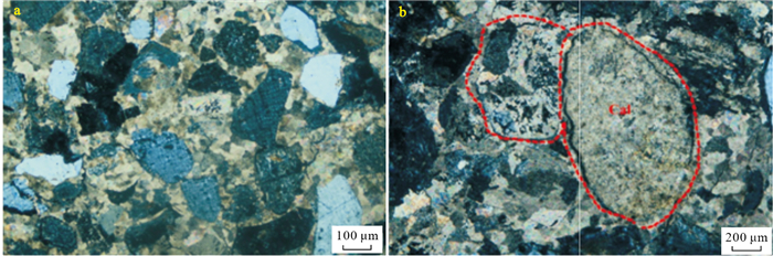
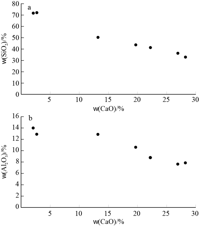
2021 Vol. 40, No. 6

Display Method:
CONTENTS
2021, 40(6)
Abstract:
Characteristics of reservoir-source rock and hydrocarbon accumulation model of tight sandstone gas reservoirs in the third Member of Xujiahe Formation in western Sichuan Depression
Cai Ningbo, He Lei, Wang Xiaolong, Peng Xiaobo, Zhuo Junchi, Zhang Ling, Liu Ziping, Li Yizhen
2021, 40(6): 1-14. doi: 10.19509/j.cnki.dzkq.2021.0528
Abstract:
The tight gas reservoirs of the Xujiahe Formation in western Sichuan Depression have become an important field for expanding oil and gas exploration and discovering new reserves.The development characteristics of tight gas reservoirs and their accumulation mechanism have become one of the key scientific problems that need to be solved urgently. Applied geochemistry, geophysics and sedimentology analysis methods, systematic analysis of the source and reservoir characteristics and accumulation model of the Xu-3 Member was conducted, and the high-efficiency source rocks and high-quality reservoirs were identified and predicted. The accumulation period and accumulation mode were determined.The following conclusions were drawn: ①The lacustrine source rocks in the mature and highly mature stage of the Xu-3 Member in western Sichuan Depression are dominated by type Ⅲ kerogen, and occasionally type Ⅱ2 kerogen.It is developed as a high-efficiency source rock when it is developed near the largest lake flooding surface in the lower sub-segment of Xu-3, with shale content above 65% or a single layer with a large thickness and requiring 1.50% ≤ TOC ≤ 10%.②According to the median value of sandstone grain size, the 4th stage (S1, S2, S3 and S4) high-quality reservoirs were identified, which belonged to low-porosity and ultra-low-permeability-ultra-low-porosity and ultra-low-permeability tight reservoirs. Reservoir space is dominated by secondary pores, micropores and microfractures.Most developed in the front edge of the delta and a small amount developed in the front delta.The particle size distribution range is 0.5-0.062 5 mm, the thickness is generally 5-10 m.③The hydrocarbon generation and expulsion time of the Xu-3 Member source rock in western Sichuan Depression lasted longer, and the Middle Jurassic began to generate hydrocarbons until the end of the Early Cretaceous; the Late Jurassic began to expel hydrocarbons and reached a peak at the end of the Early Cretaceous.High-quality reservoirs experience early natural gas continuous charging and late condensate gas charging.The natural gas charging time is earlier than the condensate gas charging time.The accumulation mode of tight gas reservoirs in the Xu-3 Member is "vertical fault transmission, first gathering and then dense, and later transformation and adjustment".
Influence of asphaltene deposition on oil seepage characteristics
Li Xinwen, Zhang Guowei
2021, 40(6): 15-23. doi: 10.19509/j.cnki.dzkq.2021.0602
Abstract:
Asphaltene deposition not only damages reservoir physical properties, but also affects fluid saturation distribution and seepage characteristics.The oil-water, oil-gas and three-phase relative permeability curves with or without asphaltene deposition were measured by long core displacement experiments under different development modes, and the effects of asphaltene deposition on oil relative permeability and rock wettability were studied.The results show that the asphaltene deposition reduces the oil recovery by 12.2%, 5.9% and 15.3% for water flooding, CO2 immiscible flooding and water-altemating-gas WAG flooding, respectively.And it will cause the displacement pressure difference to rise, the wettability of rock to change to lipophilic, and accelerate the breakthrough time of water/gas.Asphaltene precipitation in water flooding will make the oil-water two-phase co permeability zone move to the left, and the influence of water saturation on oil phase relative permeability increases.In CO2 immiscible flooding, asphaltene precipitation has little effect on gas permeability, while oil permeability is more easily affected by the change of gas saturation.In three-phase flow, asphaltene precipitation can reduce oil permeability, accelerate the decline of oil relative permeability, increase residual oil saturation and weaken WAG flooding effect.After adding JCF-1 nonionic surfactant into the injected water, the displacement pressure difference can be reduced, the breakthrough time of water/gas can be delayed, the relative permeability of oil phase can be increased, the residual oil saturation can be reduced, and the damage caused by asphaltene deposition can be made up.The research results provide a basis for efficient development of asphaltene rich reservoirs.
Numerical simulation of tectonic stress field and prediction of fracture target in the Longmaxi Formation, southeastern Chongqing
Li Xiao, Wu Liming, Wang Bingxian, Hu Qiuyuan, Dong Dawei
2021, 40(6): 24-31. doi: 10.19509/j.cnki.dzkq.2021.0603
Abstract:
Shale reservoirs are well developed in Southeast Chongqing, of which the Longmaxi Formation is the main reservoir.Compared with other types of reservoirs, structural fractures are very well developed in this type of shale reservoirs, making this area potential for shale exploration.In this paper, based on the field survey data and typical regional geological sections, structural characteristics of the study area were analyzed.On this basis, a geological model for the shale reservoir was established.In order to restore the process of structural evolution within the study area of the Himalayan period, further, the finite element analysis software Ansys 15.0 are used.Simulation results fit the actual structural development well.Based on the results as well as Griffith fracture criterion and Coulomb-Moore fracture criterion, multiple influencing factors of shale reservoirs were comprehensively analyzed, and comprehensive fracture development coefficient IF were used to quantification of the fractures distribution prediction in shale reservoirs.The larger comprehensive fracture development coefficient IF is, the more developed the shale reservoir fractures would be.Therefore, shale reservoirs in the study area are classified into three categories: fracture favorable zone Type Ⅰ(IF ≥ 3.0, fracture very well developed), fracture favorable zone Type Ⅱ(3.0, 2.0], fracture good developed) and fracture favorable zone Type Ⅲ(2.0, 1.0].
Age attribution of coal bearing strata in Beishan Basin Group, Ganmeng area
Niu Haiqing, Han Xiaofeng, Wu Jun, Wang Baowen, Xu Haihong, Song Bo, Xu Wei
2021, 40(6): 32-42. doi: 10.19509/j.cnki.dzkq.2021.0621
Abstract:
A large number of coal bearing strata are developed in Beishan Basin Group of Ganmeng area.However, due to the complexity of tectonic evolution, lack of seismic, drilling and related paleontological data, the age of coal bearing strata has been controversial, and the potential of resources is not clear.On the basis of summarizing the previous research results, taking paleontology chronology as the starting point, combining the characteristics of rock assemblage, coal industrial characteristics, seismic data, outcrop data and other evidence, the age attribution of coal bearing strata in Beishan Basin Group is studied.According to the analysis of sporopollen paleontology, coal petrology industrial characteristics and stratigraphic contact relationship, it is considered that each basin of Beishan Basin Group has developed a set of coal bearing series, but the age of this coal bearing system is not the same.Some are Jurassic and some are Cretaceous, but the possibility of Triassic or Permian is ruled out.Only the coal bearing strata in the southern part of Zhongkouzi Basin in the southernmost part of Beishan Basin Group and the eastern part of Heiyingshan Basin in the northernmost part of the basins group are Jurassic, and the coal bearing rock series of other sub basins belong to Cretaceous.The coal bearing strata in Zhongkouzi Basin in the southern part of the basins group show a "North-South difference" consistent with the structure features.The age of the exposed coal bearing strata in the south is Middle Jurassic, and that in the north is Cretaceous.The classification of the coal bearing series provides a basis for further determining the resource potential of Beishan Basin Group, and provides a reference for the study of the prototype basin restoration and tectonic evolution of the coal bearing series in the Beishan Basin Group.
Superimposed features and deformation mechanism of Early Mesozoic folds in the Sangzhi-Shimen area, northern Hunan
Yang Jun, Luo Peng, Ling Yuexin, Yang Shaohui, Bai Daoyuan, Wei Fanghui, Cao Shunhong, Peng Nengli
2021, 40(6): 43-54. doi: 10.19509/j.cnki.dzkq.2021.0605
Abstract:
A series of Jurassic-type folds have continuously developed in the Mesozoic from the Sangzhi-Shimen area in northern Hunan. The analysis of the fold superimposition characteristics is of great significance to explore the deformation period and deformation mechanism of the Sangzhi-Shimen complex oblique folds, and also for the theoretical study of fold deformation controlled by faults. Based on the measurement of geological structure section and analysis of fold superimposition characteristics in Sangzhi-Shimen area, two fold structures in Indosinian and early Yanshanian were identified. The low-angle unconformity contact between the Jurassic and the Middle Triassic in the study area, and the high-angle unconformity contact between the Cretaceous and the Pre-Cretaceous reflect two deformation events of Indosinian and Early Yanshanian movement. It can be further inferred that the folds in the Sangzhi-Shimen area can be divided into two phases: the Indosinian movement and the early Yanshanian movement.The Indosinian fold axial trace mainly showed NEE to near EW; the early Yanshanian fold axial trace can be divided into two groups, one is NEE-near EW, the other is NNE. Two groups of early Yanshanian folds and pre Indosinian folds are superimposed to form two types of superposed folds, the enhanced type and the oblique limited type. The former is controlled by the inherited activities of the Indosinian NEE-near EW reverse fault; the latter is controlled by NNE trending reverse fault, which formed by NWW trending regional compressive stress in early Yanshanian, and it is limited by the pre NEE-near EW trending structure.This deformation mechanism well explains that the fold axis and thrust fault in the study area have no east or Southeast inclined polarity.
Mineralogy, geochronology and occurrence state of the Duanfengshan Nb-Ta deposit in Mufushan area
Zhu Mingming, Zou Jianlin, Wang Chuang, Feng Chao, Fu Honglin, Zhao Peng, Chen Yang, Xu Haijun
2021, 40(6): 55-69. doi: 10.19509/j.cnki.dzkq.2021.0606
Abstract:
The two large niobium-tantalum deposits, Duanfengshan in the north margin and Renli in the south margin, were reported in the Mufushan area located in the junction of Hubei, Hunan and Jiangxi provinces.In this paper, we present field geological survey, mineralogical and geochronological investigations on the Duanfengshan Nb-Ta deposit, which are important to reveal the metallogenic characteristic, ore genesis and prospecting direction of the Nb-Ta deposit in the Mufushan area.The Duanfengshan Nb-Ta deposit is a typical granitic pegmatite type Nb-Ta deposit.It is mainly located in the densely distributed pegmatite area within the contact zone between the northern Mufushan composite granite and Lengjiaxi Group.The Nb and Ta elements are commonly enriched in the muscovite-ablite pegmatite, and are mainly hosted in the independent manganocolumbite minerals which commonly associated with albite, muscovite and quartz.Laser ablation-inductively coupled plasma-mass spectrometry (LA-ICP-MS) U-Pb dating of columbotantalite from the Nb-Ta pegmatite yielded concordant ages of 136.6-136.2 Ma, which denotes the Nb-Ta mineralization age.The data indicate that the ore forming elements of Nb and Ta are probably enriched from the evolution and differentiation of Mufushan granite magma, while the crystal nucleation and growth of Nb and Ta bearing minerals are influenced and controlled by many factors especially the fluid melt of late stage magma as well as the host country rock of biotite gneiss.
Experimental study on the effect of fillers on fracture closure in fault-karst reservoir
Kong Qiangfu, Shang Genhua, Liu Kunyan, Li Xiaobo
2021, 40(6): 70-76. doi: 10.19509/j.cnki.dzkq.2021.0607
Abstract:
Fracture is an important percolation channel in fault solution reservoir, and its closure law under geostress has an important influence on reservoir permeability.The physical simulation experiments of carbonate rock samples were carried out to study the influence of fracture occurrence (vertical fracture and high angle fracture) and filling on the law of fracture closure.The fracture specimen is prepared by Brazilian splitting experiment and wire cutting method, and the fracture deformation analysis method based on CT scanning gray image is constructed.The fracture closure is characterized by core permeability and fracture width.The results show that the fracture width and specimen permeability decrease gradually with the increase of pressure; the stronger the ductility of the filler is, the more obvious the fracture closure under pressure is, and the greater the decrease of permeability is; for quartz-filled cracks, the fracture permeability is different under different filling methods, and the supporting effect on the fracture is as follows: single layer fine sand > thick layer fine sand > medium sand and fine sand mixed.
Geochemical characteristics of epigenetic alteration and its constraints on mineralization in lower segment of Zhiluo Formation, Shuanglong area, southern Ordos Basin
Liu Yang, Wang Junli, Cao Huifeng, Ji Bo
2021, 40(6): 77-87. doi: 10.19509/j.cnki.dzkq.2021.0608
Abstract:
Green-color sandstone illustrates close association to the deposition of sandstone-type uranium via field exploration, which is similar to the Dongsheng area. Geochemical research on acidolysis hydrocarbon, Th/U, Fe3+/Fe2+ and organic carbon content in Zhiluo Formation were conducted, aiming to decipher the uranium mineralization in the green color sandstone.The result shows that: (1) Primary gray sandstone hold the higher content of hydrocarbon than the green altered and oxidized ones, and then the green altered sandstone.(2)Both oxidized sandstone and green alteration sandstone were chartererised by high Th/U (0.37-1.82) and low organic content (0.01%-1.24%).Green alteration was probably triggered by intensive reduced material, that is, the secondary reduction of reducing fluid.The early interlayer oxidation provided the material basis for uranium mineralization, and the later secondary reduction preserved the integrity of the ore body.This study has an important indication for the discrimination and division of interlayer oxidation zone in this area, and provides an important basis for the study of metallogenic regularity of sandstone type uranium deposits.
New discovery and prospecting prospect of sandstone type uranium deposits in Duolun Intermountain Basin, Inner Mongolia
Jiang Xiaojun, Miao Aisheng, Li Huaming, Ren Quan, Li Tianyu, Tu Ying
2021, 40(6): 88-96, 105. doi: 10.19509/j.cnki.dzkq.2021.0609
Abstract:
This paper reports the first discovery of sandstone type industrial uranium mineralization in the Duolun Intermountain Basin in the Mesozoic volcanic rock area of Southeast Inner Mongolia by No.208 Geological Party, CNNC.In order to understand the type of uranium mineralization, uranium metallogenic conditions, mineralization and prospecting prospects, the field geological phenomena, microscopic characteristics, petrology, mineralogy, geochemistry and mineralization patterns were studied in the basin.This paper discusses the characteristics and metallogenic conditions of the newly discovered sandstone type uranium mineralization.The strong Mesozoic volcanic activity and basement subsidence in Duolun Basin provided a good tectonic environment for the formation of uranium bearing formations.The widely distributed acidic volcanic rocks provide abundant uranium sources.The sand body of the target layer is loose and permeable, with moderate thickness (about 40 m), which is conducive to the continuous infiltration of oxygen-containing and uranium-containing water, and has complete oxidation-reduction zoning.All these are favorable for uranium mineralization.According to the existing exploration results, combined with the basin evolution and the wide distribution of regional Intermountain Basins, it is considered that the Duolun Intermountain Basin has a good prospecting prospect for uranium, and there may be rich and thick ore bodies in the deep.In the next step of uranium exploration, attention should be paid to the lacustrine deposits and beach deposits on both sides of the Duolun ancient river.
Dynamic response charactertstics of long petroleum pipelines extending along mountain ridge under strong earthquake
Yang Dashen, Chen Tingjun, Jiang Hongtao, Xiao Shiguo, Yang Hufeng
2021, 40(6): 97-105. doi: 10.19509/j.cnki.dzkq.2021.0610
Abstract:
There are many long petroleum pipelines extending along mountain ridges in the mountainous areas of western China.Dynamic responses of the pipelines under strong earthquake have significant effect on their safe service ability.It is necessary for the related investigations to provide guidance for practical construction of the pipeline projects.In terms of a typical section of this kind of oil pipelines at Longmacao village, Yusi, Yunnan, a pipeline-slope 3D numerical simulation model is established considering engineering geology conditions of the slope.Further, dynamic responses of the pipeline including its displacement, axial force, shear force and bending moment as well as overall stability of the pipeline-slope system are computed using FLAC3D program with inputting Wenchuan seismic wave, and the seismic responses at some typical moments such as the moment at peak value of the horizontal acceleration and after the earthquake are specifically obtained.The results show that internal forces of the pipeline reach their maximum values after the earthquake, and the axial force gets high level under strong earthquake but the shear force and bending moment are in small level with about 1% magnitude of the former.Besides, vertical seismic wave has little effect on internal forces of the pipeline, and the position of the maximum internal forces is near the intersection of the pipeline and fault.During strong earthquake, the pipelines appear mainly elastic and plastic deformation in the horizontal and vertical direction, respectively.The accumulated deformation is the major factor to influence internal forces of the pipelines, whose maximum occurs at the moment after the earthquake.
Application of SVR attribute fusion constrained by geological model in reservoir description of shallow water delta: A case study of X gas field in Xihu Sag
Li Wenjun, Yue Dali, He Xianke, Duan Dongping, Long Tao, Wang Wei, Chang Yinshan
2021, 40(6): 106-113. doi: 10.19509/j.cnki.dzkq.2021.0611
Abstract:
X gas field is located in the central inversion structural belt of Xihu Sag, East China Sea Basin.The main target layer H4 is in shallow water delta sedimentary environment.The dominant frequency of seismic data of the gas field is low (25 Hz), while the buried depth of H4 layer is large (3 300-3 400 m).The reservoir has low porosity and low permeability, and the consistency of sand body thickness predicted by conventional seismic inversion is low.Aiming at the characteristics of full coverage of 3D seismic data and less drilling in X gas field, this paper makes up for the lack of sample points in SVR algorithm through forward and inverse modeling under the guidance of geological model and setting up virtual wells.Then, by extracting seismic attributes and optimizing sensitive attributes characterizing sand body thickness, SVR algorithm is used for multi-attribute fusion to complete the quantitative prediction of H4 sand body.Based on the reservoir prediction results, it is proposed that H4 layer is a distributary channel deposit of shallow water delta meandering flow type, and further completed the dissection of sand body deposition model.After the development adjustment wells drilled, the coincidence between the actual drilled sand body thickness and the predicted sand body thickness is more than 84%.This paper explores and obtains the quantitative reservoir prediction scheme of SVR algorithm constrained by geological model under the condition of few wells on the sea, which completes the accurate prediction of the middle and deep distributary channel reservoir in X gas field, and also has certain guiding significance for the reservoir description of the same type of oil and gas fields.
Location characteristics of tremolite jade from Dahua, Guangxi
Yin Zuowei, Wang Wenwei, Zhou Qingchao
2021, 40(6): 114-123. doi: 10.19509/j.cnki.dzkq.2021.0612
Abstract:
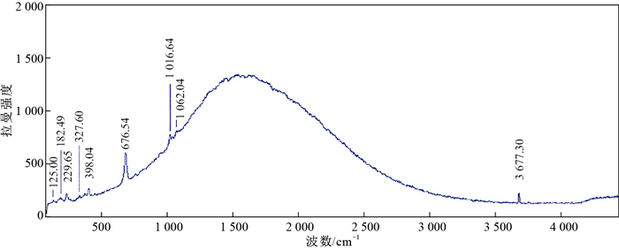
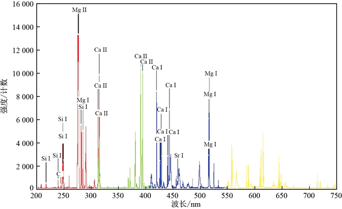
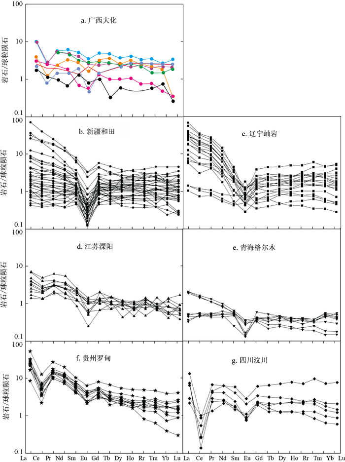
The tremolite jade found in Dahua County, Guangxi Province, is a new type of tremolite jade that has only appeared in the past two years with a low degree of research. But the jade in this production area occupies a large share in the market. It is of great significance to systematically study the gemological characteristics and origin attributes of tremolite jade in this area. Through routine tests, Raman spectroscopy (Raman), X-ray powder diffraction (XRD), inductively coupled plasma mass spectrometry (ICPMS), laser-induced breakdown spectroscopy (LIBS) and other tests, the inclusion characteristics, spectral characteristics, structural characteristics and composition characteristics of tremolite jade in this area are studied to interpret the origin attribute of tremolite jade in this area. The results show that the main mineral components of Dahua tremolite jade are relatively stable, such as SiO2, MgO and CaO, While the coefficient of variation of minor mineral components MnO, FeO and TiO2 is relatively large. The contents of trace elements B, Cr, Zn and Sr are relatively high, the contents of V, Co and Ni are relatively low, and the content of Mg2+/(Mg2++Fe2+) is 0.03, indicating that the main mineral is tremolite and the tremolite jade in this area is formed by contact metasomatic metamorphism, characterized by low iron and high calcium; From the rare earth elements contained in the sample, the total amount of rare earth elements ΣREE of tremolite jade in the mining area is low, the differentiation of light and heavy rare earth elements is not obvious, belonging to the enrichment type of light rare earth elements, the rare earth distribution mode belongs to the right dip type, relatively flat, Eu negative anomaly and obvious Ce negative anomaly; The average crystallinity of tremolite jade in this area is 0.963, which is greater than that of Xinjiang tremolite jade by 0.843, which is close to that of Qinghai(0.96), which reflects that Dahua tremolite jade has high crystallinity, relatively large crystal particles and good crystallization environment; The ratio of beryllium/silicon intensity(IBe/ISi) by LIBS of tremolite jade in this area is: 0 for tremolite jade in Dahua, Guangxi, China, 0.003-0.008 for tremolite jade in Xinjiang, China, 0 for tremolite jade in Qinghai, China, 0.004-0.006 for tremolite jade in Liaoning, China, 0.1-0.16 for tremolite jade in Korea and 0.03-0.05 for tremolite jade in Russia. The comparison between the above information and other places of origin provides a reference for traceability.
Discovery and geological significance of gas-liquid spouting expulsion and effusion depositional structures at Xialei manganese deposit in Guangxi
Lu Ankang, Zhou Qi, Qin Yongjun, Zhu Luyan, Yuan Liangjun, Huang Zongtian
2021, 40(6): 124-139. doi: 10.19509/j.cnki.dzkq.2021.0613
Abstract:
The Daxin Xialei Devonian manganese deposit in Guangxi is the first super-massive manganese ore deposit ever discovered in China. Here we conducted detailed petrographic studies on manganese-bearing sequence, ore mineral assemblages and their textures and structures. Our work reveal that the brecciated, vein-bearing and stockwork manganese ore minerals may form correspondingly to the expulsion and effusion of the gas and liquid-rich fluid. In addition, prevailing manganese-bearing silicate and sulfide minerals (rhodonite, manganese-iron chlorophyllite, pyrite, chalcopyrite, manganite, etc.) of hydrothermal origin are observed among the ores. Further comprehensive examinations of the original borehole data of the mining area lead to two major outcomes.First, three syndepositional faults are successfully recovered and identified in Late Devonian Xialei-Tuhu Ⅳ-graben basins, which controls the formation and spatial distribution of the manganese ore deposit.Second, brecciated manganese ore minerals appear to be clustered in space, and the localities of which may correspond to the locations of the ancient gas-liquid expulsion and effusion centers that give rise to the formation of manganese ore. Notably, the spatial distribution of the fossilized gas-liquid centers is controlled by the syndepositional faults developed during the formation of manganese ore deposit. Given the observation that Xalei Devonian manganese ore deposit shares comparable expulsion and effusion depositional features to Nanhua Datangpo gas-liquid depositional manganese ore deposit at Songtao of Guizhou Province, it is therefore argued that both Xialei and Datangpo manganese ore developed by similar mechanisms. This study sheds light on a better understanding of the metallogenic mechanism(s) and will place better constraints on the future explorations of Xialei manganese ore deposit.
Sedimentary characteristics and model of shallow sea sandy debrisflow: A case study of Ying Ⅱ Member in the Dongfang 1-1 Gas Field, Yinggehai Basin
Zhang Leigang, Qu Hongjun, Chen Shuo, Zhou Wei, Mo Fengyang, Han Xing
2021, 40(6): 140-150. doi: 10.19509/j.cnki.dzkq.2021.0614
Abstract:
There is shallow sea sandy debris flow in Ying Ⅱ Member in Dongfang 1-1 Gas Field, Yinggehai Basin.Based on the detailed description of cores, combined with well logs, seismic section, geochemical experiments and the research progress of gravity flow, the core, logging and seismic facies characteristics of shallow sea sandy debris flow in the study area are determined.By analyzing the sedimentary background of the study area, the sedimentary mechanism of shallow sea sandy clastic flow in ⅡL and ⅢU gas groups of Ying Ⅱ Member in Dongfang Gas Field is further discussed.It is found that it is characterized massive sandstone rich in mudstone floating debris and "mud-coated intraclasts", which are typical sandy clastic flow characteristics, in core facies, funnel type and bell-funnel type which jugged acutely in logging facies, medium amplitude parallel sheet reflection and low frequency parallel sub parallel blank reflection in seismic facies, sheet and flat lenticular distribution on the section.The results show that the sandy debris flow in the study area is the sedimentary mechanism of the shallow sea sandy debris flow formed by the combined action of the west delta front sediment collapse and re-transportation caused by the storm and the Red River flood gravity flow on the north side.
Three-dimensional comprehensive model and deep prediction of the Jinqingding gold deposit, Muping-Rushan metallogenic belt, Shandong, China
Li Jinmin, Huang Xin, Shi Wenjie, Wang Yongjun, Cui Kai, Kong Fanshun, Tan Jun
2021, 40(6): 151-164. doi: 10.19509/j.cnki.dzkq.2021.0615
Abstract:
The study of the three-dimensional(3D) distribution characteristics of ore-forming element geochemical field in Jinqingding gold deposit, Mouping-Rushan metallogenic belt, Shandong Province, summarizes the metallogenic law and establishes a 3D comprehensive prospecting model. It provides richer information for deep prediction and guides the direction of mine production and development. In this study, 3D modelling of the deposit and its geochemical field was carried out. Guided by the prospecting model of this deposit, the 3D geological bodies and 3D geochemical model of ore bodies were built up in this study based on comprehensive analysis upon the geological and geochemical data in this deposit, by using 3D modelling visualization technology and geostatistics. These models reveal the ore bodies features and geochemical characterization of this deposit. In order to reduce the uncertainty of the deep prospecting information, the 3D modelling of the Jinqingding gold deposit was carried out by the comprehensive information analysis and prediction of geology and geochemistry in the study area. The 3D model of the ore body shows that the ore body is wide in the middle and narrow at ends, and tends to narrow and disappear to the deep. The distribution characteristics of the geochemical field show that the elements and combination factors of Au, As, Sb, Hg, Cu, W, Sn, Co, Ni are distributed in the shallow part of the ore bodies, showing a decreasing trend of element-field strength to the deep. The characteristics of Mo and Bi are distributed deep in the ore bodies. The characteristics of Ag, Pb, and Zn are more scattered and there are multiple metallogenic centers. The 3D model of the combination geochemical field shows that the metallogenesis of gold occurred in the shallow area of the ore bodies, while it weakened in the deep. The results show that guided by the comprehensive prospecting model, the display, extraction and comprehensive analysis of 3D geological and geochemical anomaly information based on the 3D geochemical field model effectively evaluate the potential of deep prospecting and provide the evidences for deep prospecting prediction. The comprehensive analysis results show that the prospecting potential of the No.2 orebody of the Jinqingding gold deposit below -1 200 m is low-expected, and it is inappropriate to continue deep exploration massively.
Using compaction simulation experiment to recover burial history: Taking the fourth Member of Shahejie Formation in Leijia area, Western Depression of Liaohe River as an example
Zhao Xiaoyang, Dai Zongyang, Li Yang, Jiang Yubo, Gong Zhenchao, Li Tian, Huang Lan, Cui Xiaolei, Zhou Rui, Su Jing, Huang Lei, Zhou Xiaolong
2021, 40(6): 165-177, 215. doi: 10.19509/j.cnki.dzkq.2021.0616
Abstract:
The Leijia area in the Western Depression of the Liaohe River has good oil and gas exploration and development potential, but the current analysis of the burial history in this area lacks a clear understanding.This paper uses the recovery principle of subsidence history to restore the original thickness of the remaining stratum in the study area.Firstly, the sonic curve method and the adjacent layer comparison method are used to restore the denuded thickness of the stratum.Sandstone, argillaceous limestone, limestone mudstone, mudstone) were subjected to compaction simulation experiments, and the porosity-depth curve of the sample was obtained according to the experiment.Use the existing burial data to calculate the thickness of the stratum framework, and according to the constant volume formula of the framework, use each single lithological layer as the smallest unit to carry out the backstripping calculation one by one to obtain the sedimentary thickness of each group and section in different geological periods and the depth of burial.According to the analysis of burial history, during the burial process of the Cenozoic strata in Leijia area, the sedimentation rate of the Paleogene Shahejie Formation was higher and the sedimentary strata was thicker, but the second Member of Shahejie Formation was uplifted and eroded and the strata was thin; During the Dongying Formation, the stratum deposition slowed down, and the stratum was uplifted and eroded at the end; in the Neogene and Quaternary, the stratum deposition rate was low, and the thickness of the deposited stratum was not large.
Experimental study on interface frictional property between sand and concrete pipe jacking
Li Tianjiang, Chen Xuefeng, Chen Weichao, Yuan Xin
2021, 40(6): 178-184. doi: 10.19509/j.cnki.dzkq.2021.0617
Abstract:
To reveal the shear friction mechanical mechanism between concrete pipe jacking and sand, obtain the friction coefficient of pipe-soil and pipe-slurry, and provide guidance and reference for the selection of pipe jacking construction parameters and the calculation of jacking force.To that end, the shear friction behavior and mechanical mechanism were investigated between 5 types of sands and concrete pipe under different normal pressure, shear rate and lubrication state. The test results show that the stable value (residual value) of shear stress at the concrete-sand interface increases first and then decreases with the increase of sand particle size. With the increase of normal stress, the shear displacement when the shear stress of the concrete-sand interface reaches the peak or stable value increases. Meanwhile, the strain softening characteristic of the shear stress versus shear displacement curve gradually weakens and the strain hardening trend gradually obvious. Without lubrication, as the normal stress increases, the increment of shear stress stability value remains stable or slightly decreases. With slurry lubrication, the increment of shear stress stability value increases. Under lower normal pressure, the shear rate has little effect on the shear stress of sand.When using slurry lubrication, the stable value of shear stress at the concrete-sand interface can be reduced by 70%-80%, and the lubrication effect decreases with the increase of normal stress.
Influence of ground-surface deformation in pipe jacking construction with parallel differential section
Huang Jianhua, Bao Feng, Wang Yunchen, Li Hong
2021, 40(6): 185-192. doi: 10.19509/j.cnki.dzkq.2021.0618
Abstract:
The development of urban underground space and traffic promotes the wide application of large section pipe jacking technology in urban tunnel construction.The functional requirements of parallel pipe jacking tunnel are different, so shapes and sizes of the section are also different.Based on the double-line parallel pipejacking tunnel with difference large section under through the main road in the city, a three-dimensional finite element calculation model is established for systematic analysis.At the same time, combined with the measured results of the field pipe jacking project, the characteristics and influencing factors of ground-surface deformation under different sections and different construction sequence of parallel pipe jacking are studied.The results show that the surface deformation curve caused by parallel differential section pipe jacking construction is Ⅴ-curve, and the peak point of the surface deformation curve gradually shifts from the large section rectangular pipe jacking axis to the two pipe centers.The surface settlement on the left side of the axis of the small section rectangular pipe jacking is larger than that on the right side of the axis.Construction of large section rectangular pipe jacking on the left line is more beneficial to control surface deformation.The influence of section size change on surface deformation is 30%, and the influence of process on surface deformation is 8%.The influence of section size difference on surface deformation is greater than that of process difference.The study on the influence of parallel differential section pipe jacking construction on surface deformation can provide theoretical basis and experience for future related parallel large section pipe jacking projects.
Reliability analysis of slope with dominant seepage interlayer under rainfall infiltration
Xiao Jinghong, Wang Min, Wang Chuan, Leng Xianlun
2021, 40(6): 193-204. doi: 10.19509/j.cnki.dzkq.2021.0619
Abstract:
Slopes with dominant seepage interlayers (DSI)often have relatively high uncertainty in their seepage field under the action of rainfall infiltration, which brings difficulties to the stability evaluation.In this regard, probabilistic methods are usually used to analyze the stability of such slopes.For analyzing the reliability of slopes with DSI under rainfall infiltration, the point estimation-finite element method used in the stress analysis was introduced to the slope seepage-stability analysis, and a method for seepage probability and reliability analysis of slopes was developed considering the uncertainty of permeability of DSI.Then, by taking a soil slope with gravel interlayer acting as DSI in Guangxi Province as the engineering case, the seepage probability of DSI under rainfall infiltration was analyzed, and then the slope reliability analysis was conducted based on the seepage probability.Results show that:① In the slope with DSI, the depth of rainwater infiltration along DSI is significantly higher than that along the slope surface; the uncertainty of the permeability of DSI has a great impact on the seepage field, which results in the strong uncertainty of slope stability; ② With the rainwater infiltration in the slope with DSI, the failure probability of different potential slip surfaces generally increases, and the position of the most dangerous slip surface evolves from the upper part to the lower part of the slope. The prediction of the position of slip surface is consistent with the practice; ③The proposed probability analysis method, with the advantages of small calculation amount, is suitable and can be used as a new method for analyzing the stability of slopes with DSI under the influence of rainfall infiltration.
Effect factors analysis and characteristic of freeze-thaw deformation of fracture rock
Cui Shenghua, Yang Qingwen, Rui Xuelian, Zhang Yuyang
2021, 40(6): 205-215. doi: 10.19509/j.cnki.dzkq.2021.0620
Abstract:
In the cold and high-altitude regions of Sichuan Provence, the rock failure caused by freeze-thaw deformation has a significant impact on projects. In order to study the cyclic freeze-thaw characteristics of rock mass under different fracture conditions, the phyllite and sandstone were taken from this area. The rock samples with different joint lengths, opening, number of joints were conducted with 50 cycles of freeze-thaw tests under ±20℃. The test results showed that the saturated rock had process of freeze contract→freeze expand→freeze contract→thaw expand→thaw contract→thaw expand. The dry rock had process of freeze contract→melt expansion. The relationship between freeze-thaw cycle times and εd was studied. The length of joint, opening and number of joints had an influence on freeze-thaw deformation of dry sample. Select the residual deformation εr as an index to study the increasing of εr with increasing of εd for phyllite and sandstone samples under the water saturation conditions. The relationship between εr and εd had been obtained. The decreasing of uniaxial compressive strength of dry and saturated samples with increasing of the number of freeze-thaw cycles was analyzed. The linear relationship between freeze-thaw times and sample deterioration was determined. Finally, the influence mechanisms of water saturation condition, lithology and fracture condition on freeze-thaw cyclic deformation of rock mass were discussed.
Prediction and discrimination of the Middle Carboniferous inner platform shoal distribution at the eastern margin of Pre-Caspian Basin: Taking the North Truwa slope area as an example
Xu Chenhao, Liang Zhiguo, Cheng Junsheng
2021, 40(6): 216-225. doi: 10.19509/j.cnki.dzkq.2021.0604
Abstract:
The Middle Carboniferous KT-Ⅱoil formation in the eastern margin of the Pre-Caspian Basin is widely developed with open platform facies intra platform beach.The sedimentary environment is open and stable, and the terrain is flat.The intra platform beach often floats in isolated micro geomorphic Highlands in the platform, so its distribution is often difficult to predict.Drilling practice shows that the beach facies in the platform is the basis of constructive diagenesis in the later stage, and it is also the main controlling factor for the formation of high-quality reservoir, so it is very important to predict its distribution.In order to improve the accuracy of beach prediction, based on the analysis of regional sedimentary evolution, and gradually carry out three-dimensional seismic attribute analysis and high-resolution inversion, fully combined with the predictability of seismic data and the regularity of geological knowledge, through summing up the geological law of facies belt, the seismic reservoir prediction is supplemented and screened, so as to achieve the unity of geological and geophysical knowledge.The results show that the statistical inversion under the control of seismic attribute trend can accurately describe the spatial distribution characteristics of thin beach body at the level of small layer.According to the sedimentary law, the predicted beach bodies are screened and classified.Among them, there are 7 first-class beach bodies, 4 second-class beach bodies and 3 third-class beach bodies.The first- and second- class beach bodies have been confirmed by drilling, which are consistent with the sedimentary law.The third-class beach bodies are contrary to the geological understanding and should be screened out.The research results have established a complete technical system for the prediction of concealed beach bodies in this area, and have seen actual results.At present, the success rate of drilling for a class of beach bodies is as high as 100%.
Particle distribution characteristics of rock avalanche and the interaction between rock avalanche and houses based on image recognition
Peng Shuangqi, Ke Ling, Zheng Ti, Xu Jizhong
2021, 40(6): 226-235. doi: 10.19509/j.cnki.dzkq.2021.0622
Abstract:
Due to the high concealment, short-lived time and low predictability of the rock avalanche, it is difficult to visually observe the process of it. In order to study the dynamic characteristics and the catastrophicto houses of rock avalanche, this paper analyzes the rock avalanche congeries and its particle size distribution.Taking the rock avalanche in Pusa Village as an example, this paper uses the PCAS system to identify congeries particles by image.And through the dimensional analysis method, the quantitative relationship between the congeries of particles and the damage of the building is analyzed.The author found that: compared with on-site screening statistics, the data obtained by the method of image recognition of congeries particles is more comprehensive and detailed, and can save a lot of manpower and material resources.In addition, the interaction between the house and the rock avalanche is explored, and it is found that the house has the effect of "blocking coarse and fine discharge" on the rock avalanche particles. At the same time, using the particle size data obtained by image recognition to derive the discrimination formula for building damage, the discriminating effect is good, laying the foundation for follow-up research.
Deformation characteristics of building foundation under different action modes of landslide
Yu Yuting, Gui Lei, Zhu Xinghua, Han Youming
2021, 40(6): 236-245. doi: 10.19509/j.cnki.dzkq.2021.0623
Abstract:
Due to the topographic conditions, a large number of houses are built on the landslide in the southwest mountainous area, which have potential safety hazard. It is of great significance to explore the action mechanism between landslide and buildings and scientifically guide the design and protection of houses on landslide, so as to ensure the safety of residents' lives and property and promote the harmonious development of people and land. The foundation is the direct object of the landslide on the house. Therefore, taking the masonry structure house foundation as the research object, the deformation characteristics of the foundation in the test and simulation are compared and analyzed by using the method of physical experiment and numerical simulation, the reliability of the boundary setting of the numerical model is verified, and the deformation and failure characteristics of the house foundation under different landslide action modes are studied. The results show that the failure modes of building foundation under the slow deformation of landslide can be summarized into three modes: tension, shear and compression; The location of house crack development is closely related to the location of landslide surface crack. With the increase of the included angle between the main sliding direction of landslide and house foundation, the house foundation damage becomes more and more serious. Therefore, in the site selection and design of houses, priority should be given to the use of landslide extrusion area or reducing the included angle between the central axis of the long side of the house and the main sliding direction of the landslide.
Processes and sources identification of intermittent karst water inrush in Xiakou Tunnel
Luo Mingming, Zhou Hong, Guo Xulei, Chen Qianlong, Qi Lingxuan, Kuang Ye
2021, 40(6): 246-254. doi: 10.19509/j.cnki.dzkq.2021.0054
Abstract:
The investigation and prevention of karst water inrush is a difficult problem in tunnel construction. The Xiakou Tunnel has a long history of karst water inrush.To identify the source of intermittent water inrush and explore the controlling effect of karst water system to the process of water inrush, the hydrogeological survey, hydrological and hydrogeochemical methods were used to identify the sources and processes of water inrush. The results show that, there is a groundwater divide at the area of Mengjialing, and the groundwater in the northern and southern area discharge into Xianglongdong and Xiakoudong, respectively. In the events of concentrated water inrush, the total amount of event water inrush has a significant linear positive correlation with the rainfall event, and the hydrogeochemical composition of the water inrush is very similar to that of the four blind drainage ditches, which indicates that all these water inrushes and blind drainage ditches come from the karst water in the northern part of the tunnel. During the stable drainage period, the karst water in the northern part of the tunnel is mainly discharged through the blind drainage ditch on the north of the right tunnel, while the groundwater of other three blind drainage ditches come from the fissure water in clastic rock.The concentrated water inrush point is located on the surface of saturated zone in the karst water system of Xiakou. The heavy rainfall events made the upper part of tunnel to be filled with karst water.The water inrush was caused by intercepting the fast flow in karst channel, and small part of base flow was mixed into the water inrush. In the study of karst water inrush, the comprehensive utilization of multi-technical methods and multi-information verifications can improve the accuracy in the source identification of water inrush.
Distribution and influencing factors of soil selenium and iodine in Limushan-Wanling, Qiongzhong area
Gong Jingjing, Gao Jianweng, Yang Jianzhou, Wu Hui, Tang Shixin, Ma Shengming
2021, 40(6): 255-267. doi: 10.19509/j.cnki.dzkq.2021.0625
Abstract:
Qiongzhong Limushan-Wanling area is located in the middle of Hainan Island, where has an abundance of selenium-rich and iodine-rich soil resources.The distribution characteristics of Se and I contents were analyzed based on the analysis results of soil samples in the topsoil (0-20 cm), middle-layer-soil(80-100 cm), and deep-soil (180-200 cm) of the study area.The correlation characteristics of Se and I in soil and their relationship with elevation potentially indicate that the input of rainfall to soil Se and I is a key factor leading to the enrichment of Se and I.By analyzing the correlation and change law between the contents of Se, I and the contents of pH, soil organic matter, Al2O3 and Fe2O3 in top, middle and deep layer soil, the enrichment and migration of Se and I in the vertical section of soil in the study area was summarized.These results can provide scientific basis for the efficient use of local high-quality land resources and provide new evidence for the study of soil Se source and migration.
Contents, sources and ecological risk assessment of polycyclic aromatic hydrocarbons (PAHs) in agricultural soils of plantations in northern Hainan Island
Yang Jianzhou, Gong Jingjing, Ma Shengming, Zhao Jinhua, Wang Zhenliang, Su Lei, Hu Shuqi, Tang Shixin
2021, 40(6): 268-275. doi: 10.19509/j.cnki.dzkq.2021.0626
Abstract:
Hainan Island is the main planting base of tropical plants in China.Evaluating the level of soil pollution in this area has a great significance.In this study, we assessed the contamination levels, sources and ecological risk of 16 priority polycyclic aromatic hydrocarbons (PAHs) in agricultural soils of northern Hainan Island.A total of 100 surface soil samples were collected from plantations (coffee, banana, yam, sugarcane, orange, passion fruit and guava) and analyzed for PAHs concentration using gas chromatography equipped with a mass spectrometry detector (GC-MS).The average of ∑16PAHs from plantation soil was 37.6 ng/g, which was below the background of national soil and the no pollution limit of 200 ng/g determined by Netherlands.Three-, four- and five-ring PAHs were dominant components, accounting for 25.8%, 26.8% and 23.5% of the total PAHs, respectively.Source analysis suggested that PAHs of soil in these plantations were mainly derived from the exhaust gas of locomotives and partially from oil spill as well as low temperature combustion of coal and biomass.In ecological risk assessment, the benzo(a) pyrene equivalent concentration (∑16BaPeq) presented a much lower level than the guideline values announced by Chinese Environmental Protection Agency, demonstrating that the PAHs contamination level in solis was acceptable.
Discussion of geological hazard data management and application model in big data era
Liu Junqi, Liu Qiang, Liu Qianhui, Zhang Xialin, Lin Chen, Zhou Xin, Li Guoce
2021, 40(6): 276-282, 292. doi: 10.19509/j.cnki.dzkq.2021.0627
Abstract:
Geological disaster data is a kind of multi-source heterogeneous data with multi-source, large quantity, multi-type, multi-format, multi-scale and multi-precision.It is a typical "big data".Relational database is the mainstream management method of geological disaster data at present.There are a large proportion of unstructured data in geological disaster data.Because it is difficult to manage unstructured data effectively by using relational model, the effect of this management method is not ideal.This weakness will be further amplified in the era of big data, and will have a certain impact on geological data mining and big data analysis.This paper focuses on the management mode of geological disaster data in the era of big data.Discusses the management of pan-structured geological data, application model and integration of distributed heterogeneous system.It is considered that the effective management of geological disaster data should combine file system, relational database and NoSQL, and a pan-structured geological data management and application mode based on the combination of double C model and middleware is proposed.The double C model has an implicit internal data access and management center and an explicit outer analysis and application center.Through the double C model, a variety of work can be integrated into a simple and orderly whole, such as geological data collection, management, statistics, calculation, retrieval, geological map compilation, three dimensional modeling, attribute analysis, spatial analysis and so on.
Experimental analysis of spatial feature detection of the ring geomorphology at the south edge of Lufeng Dinosaur Valley based on UAV imaging point cloud
Gao Sha, Yuan Xiping, Gan Shu, Yang Minglong, Hu Lin, Luo Weidong
2021, 40(6): 283-292. doi: 10.19509/j.cnki.dzkq.2021.0628
Abstract:
In order to quantitatively obtain the characteristic parameters of complex geomorphological structures, high precision and high resolution topographic and geomorphological data are required.In the detection of complex geomorphic features, UAV aerial survey combined with imaging point cloud can accomplish the task of spatial detection of complex geomorphic features quickly, efficiently, safely and accurately.In this study, the UAV measurement technology is used to obtain high-resolution geomorphological image data, construct a realistic 3D scene model and analyse the geomorphological features of the typical local scenes of the ring-shaped landform at the southern edge of Lufeng Dinosaur Valley.The experimental results show that: ①The DSM data obtained based on the UAV imaging point cloud can accurately express the real geomorphological features of the study area by filtering, extracting thinning, classifying and other data processing to obtain the ground points and constructing 0.2 m resolution DEM data by using the progressive encrypted triangle network method.②By constructing 7 typical elevation profiles of the circular scene "inner-middle-outer", the comparative analysis confirms that the topography of the study area is characterized by the 0 profile line as the main highland ridgeline, showing a circular "basin rim" pattern, with gradually decreasing elevation on the inner and outer sides, and the elevation of the outer profile of the "basin rim" changes dramatically, and the topography is more complex than that of the inner landscape.③In order to further detect and extract the information of micro-morphological features, the accurate DEM data constructed by the principle of UAV imaging combined with the realistic 3D model of the survey area, quantitatively extracted the slope, slop direction, relative height difference, contour, ridge line valley line and other related parameters of the area for accurate quantitative measurement and analysis and discussion.④ Using the multi-view visual interpretation of the three-dimensional 3D model and the analysis of typical scenes, micro-geomorphic features such as the development of washouts in the survey area and the nodal laminated surface of the geological body can be clearly identified.Through the above experimental research on geomorphological 3D scene detection, it is easy to find that the use of realistic 3D models can quickly and accurately present the geomorphological features of the survey area, and the comprehensive analysis of imaging point cloud data can quantitatively and semi-quantitatively reveal regional geological structure information.Overall, the UAV measurement technology and imaging point cloud 3D product application in geological survey has practical significance and unique technical advantages.
Stratigraphic lithology identification based on no-dig mud property detection system and weakly-supervised learning
Xu Han, Cheng Danyi, Xu Yonghua, Yao Kongxuan, Qiu Feng, Wu Xiaoming, Lin Penghao
2021, 40(6): 293-301. doi: 10.19509/j.cnki.dzkq.2021.0629
Abstract:
In view of the lack of geological investigation information data in no-dig and the difficulty in distinguishing the lithology of tunneling stratum, a typical no-dig formation lithology identification method based on support vector machines(SVM)algorithm of no-dig mud property data is proposed.Combined with the field application of the self-designed no-dig mud property detection system, the training samples of rheological parameters, density and other sensitive mud parameters were obtained.The obtained mud parameters training samples were learned by SVM algorithm, and the mud parameters sample space was constructed.The kernel function was used to map to the high-dimensional space for classification, a classification model is established for the classification of typical no-dig strata in Shanghai.The model is applied to the no-dig engineering in Shanghai to verify its effectiveness.The results show that the method can quickly identify the drilling stratigraphic lithology under the condition of no-dig real-time drilling, and the recognition accuracy is as high as 96%.The research provide important geological information for drilling tool selection and mud design in no-dig reaming stage by collecting the mud property parameters of the guide section and identifying the formation lithology of the no-dig advance section.
Application of GF-2 remote sensing data for typical Quaternary stratigraphic survey in Gaizi River Basin
Zhang Zhijun, Xu Maqiang, Wang Ming, Li Xianju, Dong Yusen, Chen Weitao, Wu Chunming, Wang Lizhe
2021, 40(6): 302-312. doi: 10.19509/j.cnki.dzkq.2021.0630
Abstract:
The development of domestic high resolution remote sensing satellite technology provides a new means for the investigation of macroscopic, local and detailed characteristics of the Quaternary.Alluvial-diluvial fans, valley terraces, glacial deposits are widely distributed in the eastern section of China-Pakistan Economic Corridor. In order to study the applicability of domestic high-resolution data in the Quaternary geological survey of this region, the alluvial and flood fan in front of Uruat mountain along Gaizi River basin of China-Pakistan highway and three typical Quaternary strata of Gaizi River valley terrace and Kraguirake glacial moraine were selected as the research objects in this study.Using domestic GF-2 images as the main data sources, with the aid of digital elevation model data, the remote sensing interpretation marker was established, and the fine geological interpretation was carried out.The composition and variation were found out through field verification.The previous distribution range of different periods of glacial moraines in Kailaillak was revised.Based on the analysis of the terrace in Gaizi River valley, the study area experienced at least five stages of tectonic uplift since late Epipleistocene, and the terrace base was formed by at least two stages of glaciation.This study shows that GF-2 images can not only quickly identify the change characteristics of landforms and loose deposits at macro scale, but also it can get geological phenomena that cannot be observed by conventional methods.And then it can meet the requirements of large scale interpretation and cartography.Especially in the identification of micro-geomorphology and interpretation of Quaternary strata, it can improve the level of fine geological interpretation.Research results can provide basic geological data for understanding the development and evolution process of fluvial and glaciation in the Gaizi River basin.Besides, this study can provide a typical example for remote sensing investigation of Quaternary soil mass along the China-Pakistan highway.
Early identification and influence range division method of collapse hazards based on UAV oblique photography technology
Lü Quanru, Zeng Bin, Meng Xiaojun, Chen Gang, Yan Jiakang
2021, 40(6): 313-325, 334. doi: 10.19509/j.cnki.dzkq.2021.0631
Abstract:
High-level rock collapse is concealed, sudden and catastrophic. Traditional contact survey methods cannot fully guarantee the safety and also difficult to thoroughly identify the spatial distribution and development characteristics of the dangerous rock blocks on the slope. Therefore, how to obtain the key geological information on the slope surface safely, quickly and accurately has always been one of the difficulties in the investigation and evaluation of collapse disasters, and it is also an extremely important link in the disaster prevention and reduction work. Taking a high-steep rock slope in mining area in Lianyungang City as an example, the paper presents a method for early identification and influence range division of collapse hazard based on UAV oblique photography technology. The method obtains high-resolution image in the research area and constructs a high-precision geological model by oblique photography technology, uses line measurement method to extract and statistics the spatial spreading characteristics and related parameters of the dominant structure surfaces in the slope, determines instability mode of critical dangerous rock blocks in the slope by stereographic projection method, uses Rocfall to simulate the rolling motion characteristics of the collapse blocks under the worst condition after completing the stability evaluation and classification of the dangerous rock blocks, and finally the influence range of different levels was divided for disaster prevention and control. The research results show that the UAV oblique photography technology has significant feasibility and superiority in early identification, failure mode analysis, stability assessment and influence range delineation of collapse hazard. The method of early identification and influence range division of collapse hazards based on UAV oblique photography technology has important reference value.
Numerical simulation of working characteristics of energy pile group under thermo-mechanical coupling
Dong Longlong, Mei Guoxiong, Wu Wenbing, Wang Lixing, Ruan Hengfeng
2021, 40(6): 326-334. doi: 10.19509/j.cnki.dzkq.2021.0632
Abstract:
In order to study the working characteristics of energy pile groups, based on the Abaqus finite element simulation, assigns the average temperature of the heat transfer stable stage to the pile body for steady-state thermo-mechanical coupling calculation, and proposes a simplified analysis method for the bearing characteristics of energy pile groups.The reliability of this research method is verified through the comparative analysis with field data.Combined with an example, this method is used to analyze the bearing characteristics of energy group piles under the action of pure mechanical load and thermal coupling.The results show that the non-uniform settlement of the distributed symmetrical arrangement of energy piles in the pile group foundation is significantly less than that of the centralized arrangement, and the layout has a great influence on the response characteristics of the pile foundation structure.Under the condition of equal stiffness of pile foundation, the control effect of pile group tilt is better by increasing pile diameter and decreasing pile spacing.The research results of this paper can provide some reference value for the engineering application of energy pile group.