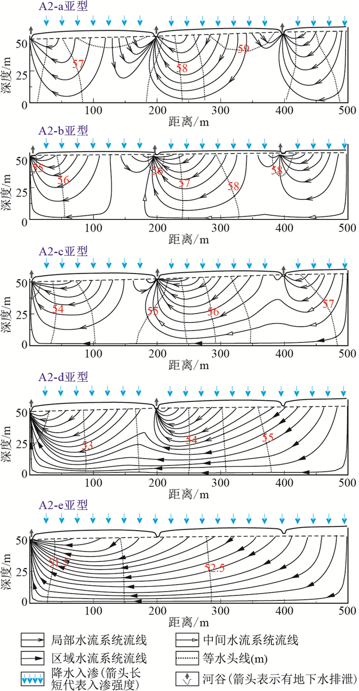
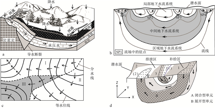
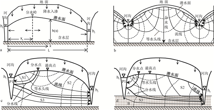
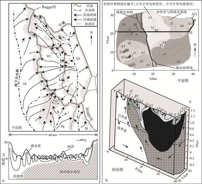
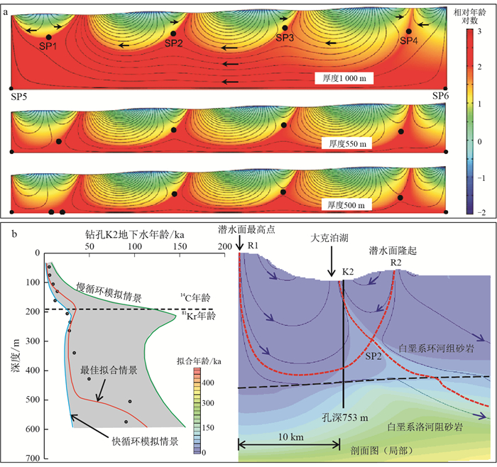
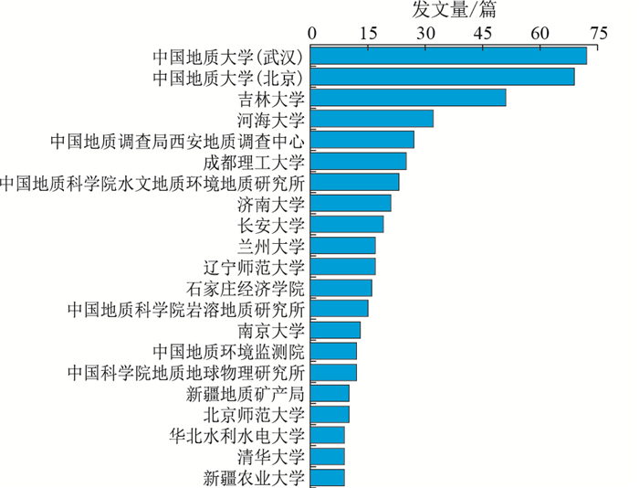
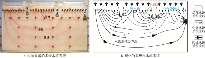
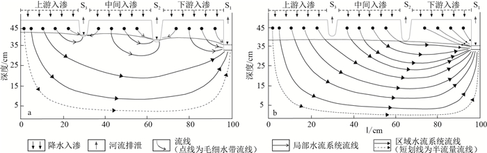
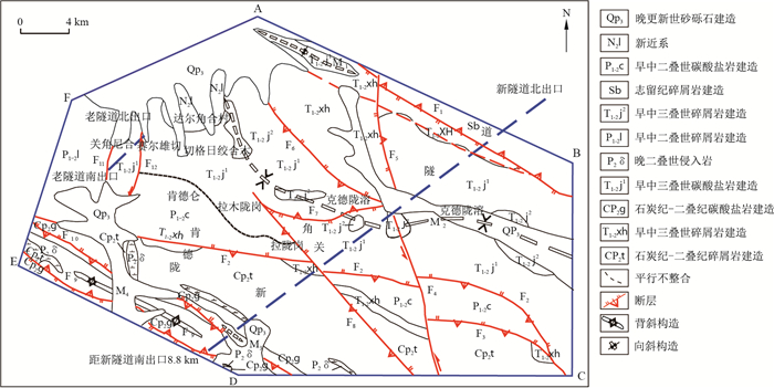
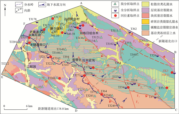
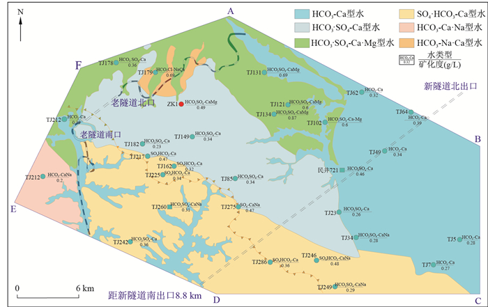
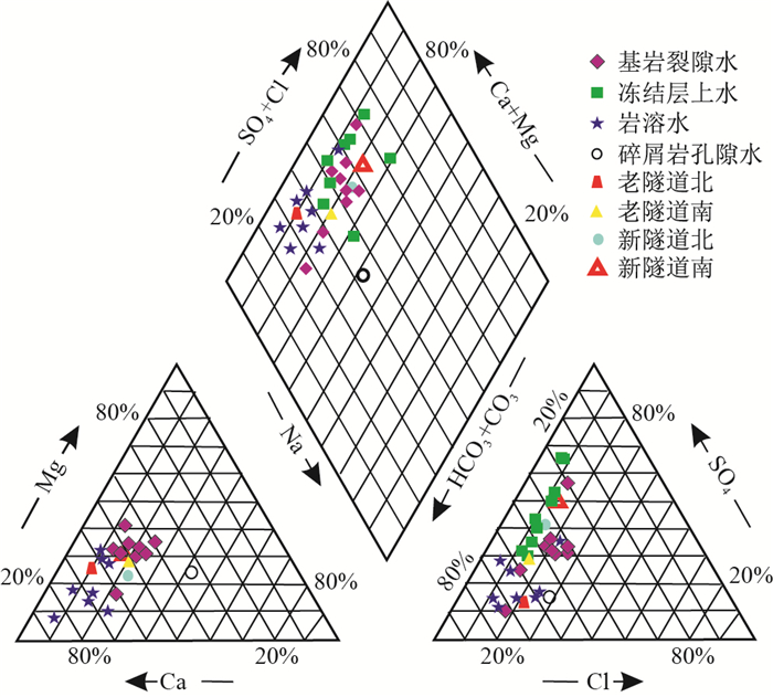
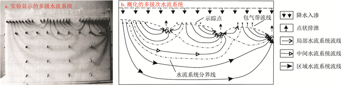
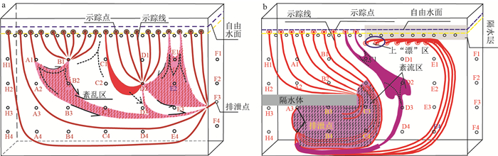
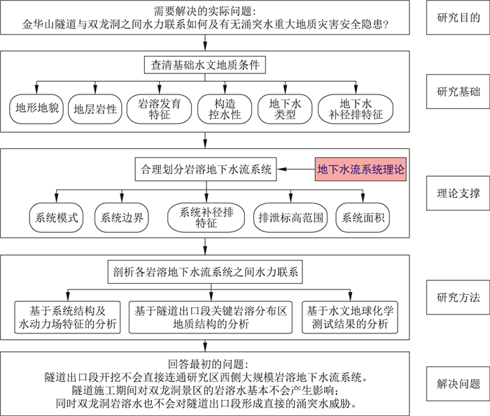
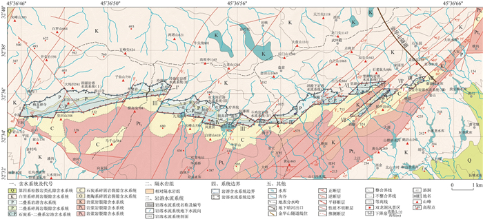
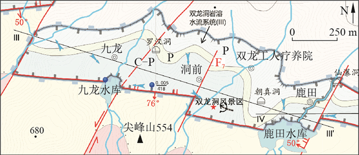
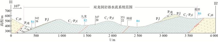
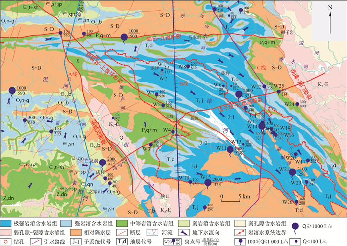
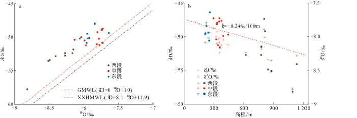
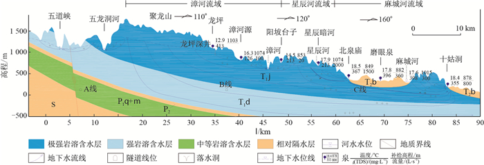
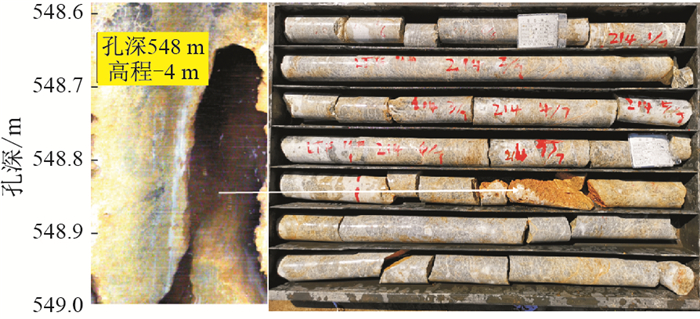
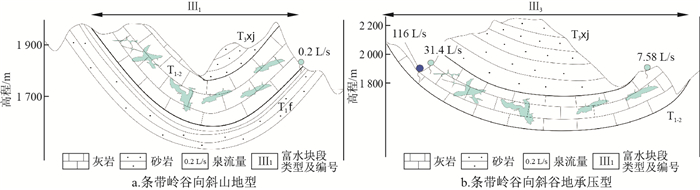
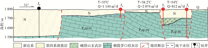
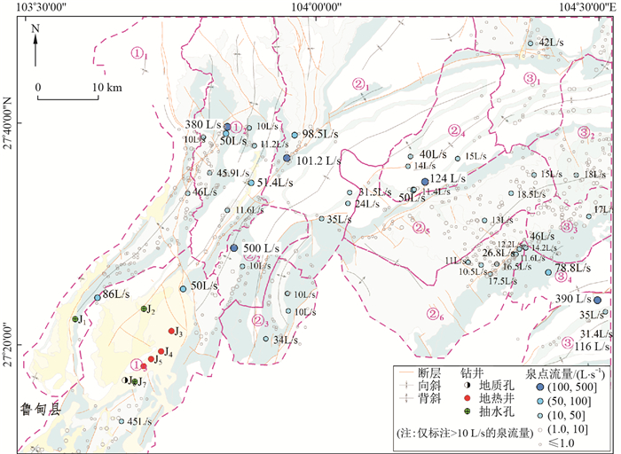
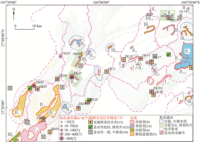
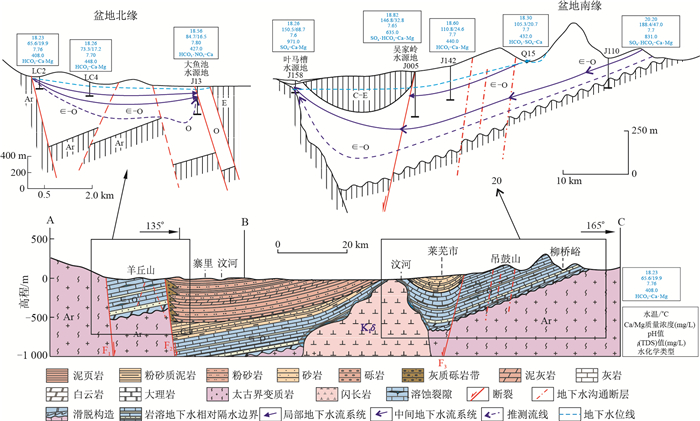
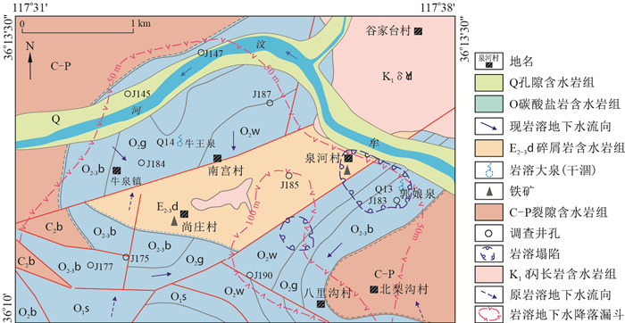
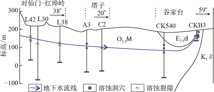
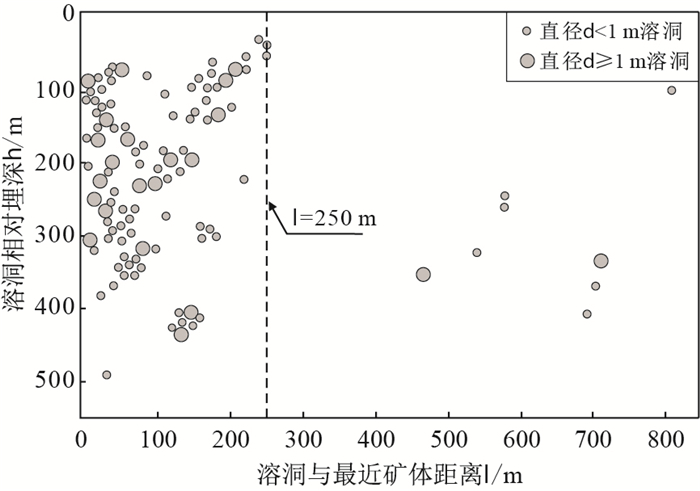
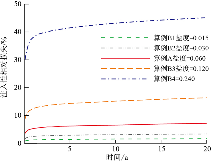
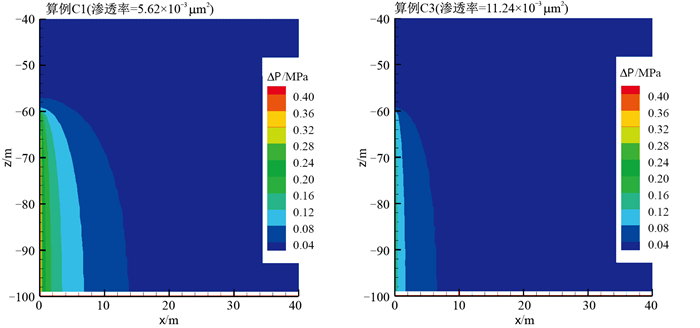
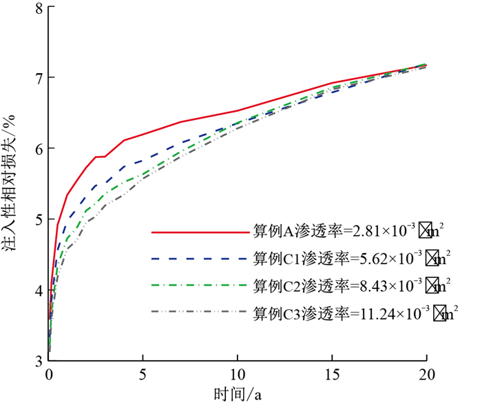
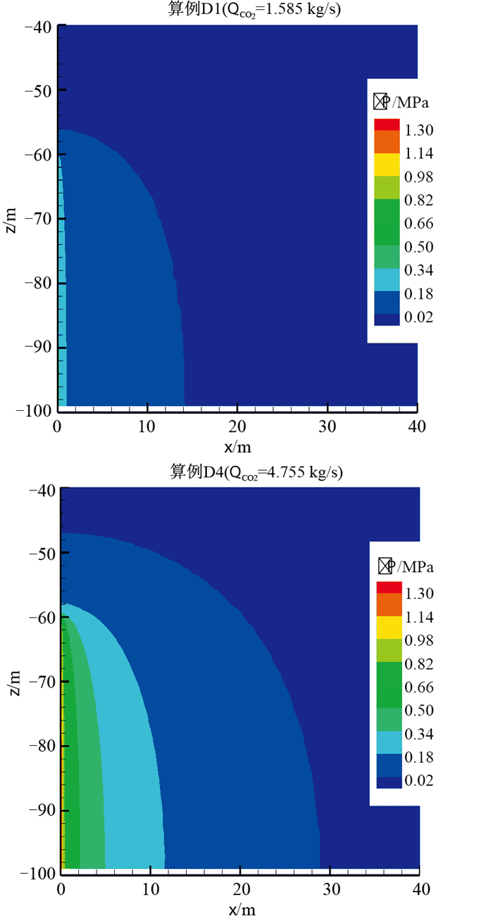
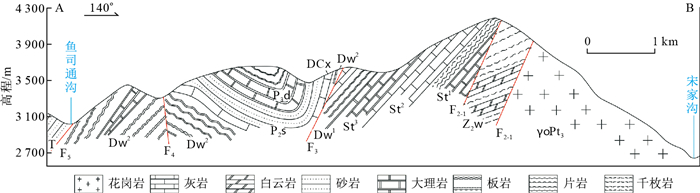
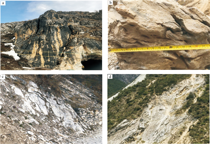
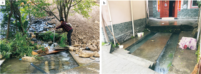
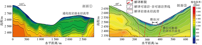
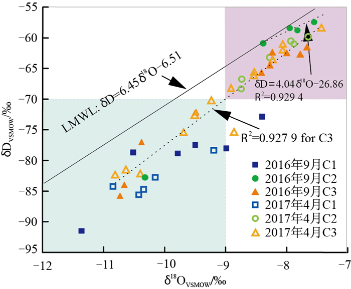
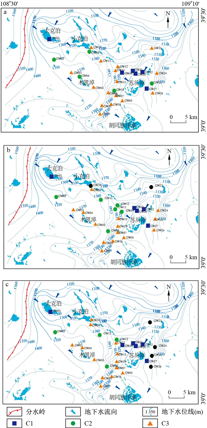
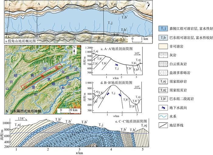
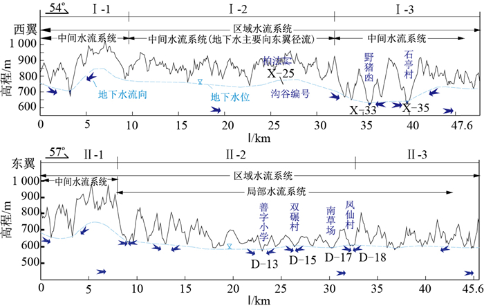
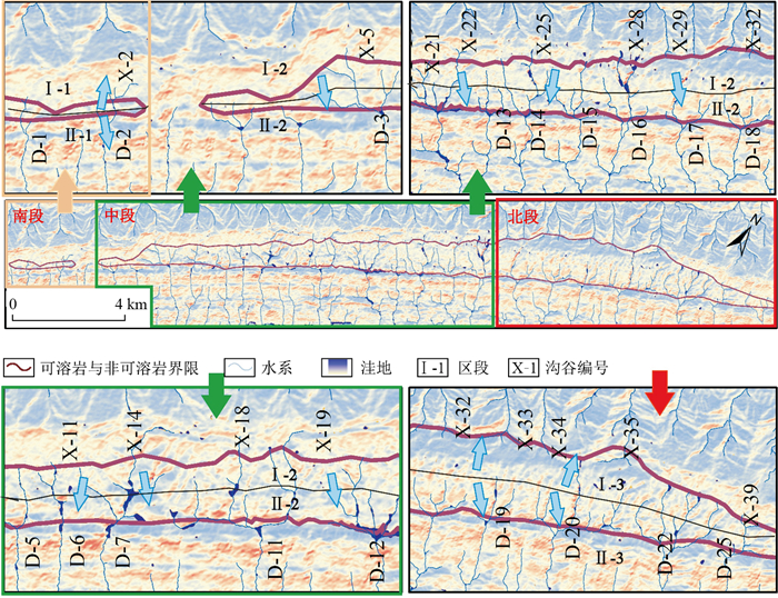
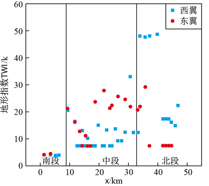
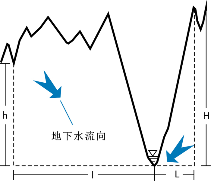
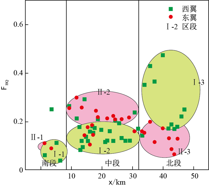
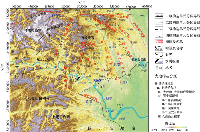
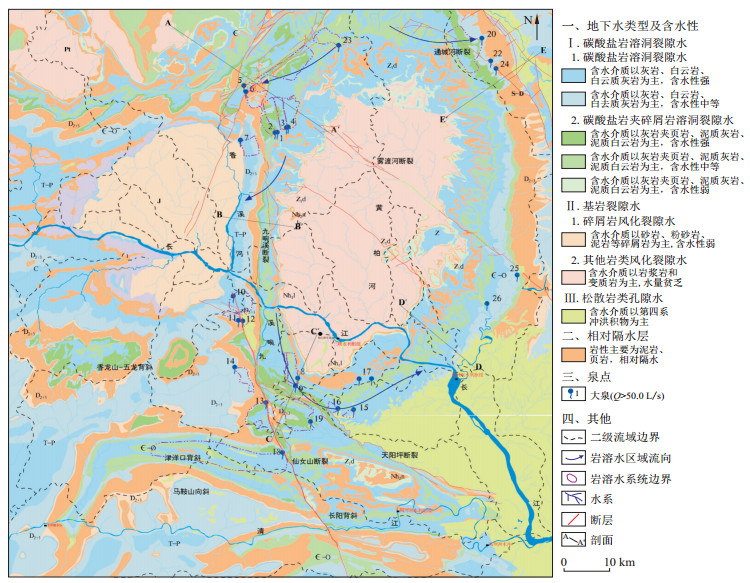
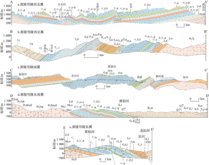
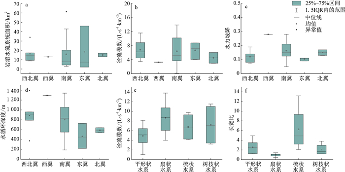
2022 Vol. 41, No. 1

Display Method:
Lacustrine groundwater discharge and lake water quality evolution
Wang Yanxin, Du Yao, Deng Yamin, Gan Yiqun, Wang Peifang, Ma Teng, Shi Jianbo, Xie Xianjun
2022, 41(1): 1-10. doi: 10.19509/j.cnki.dzkq.2022.0001
Abstract:
Lake eutrophication is one of the most typical and serious water environmental problems in the world, and input of both point-source and non-point source nutrients into lake has been the focus of previous studies.However, the role of surface water-groundwater interactions in the occurrence and evolution of lake eutrophication has been often neglected.In this paper, the patterns of groundwater-lake water interactions were summarized, the research progress on the influence of groundwater discharge on the hydrology and water quality of lake were reviewed, and the advantages and applicability of different quantifying methods such as seepage meter measurement, water balance, radon mass balance, temperature tracing, and numerical simulation) were compared.The state-of-art of the studies and major challenges in understanding the spatial-temporal variability of groundwater discharge to lakes, and the transport and transformation of nitrogen and phosphorus at the groundwater-lake interface were reviewed.And three directions for the future study in this field were proposed: 1) characterizing the spatial-temporal variability of lacustrine groundwater discharge using multiple methods; 2) accurately quantifying the loads of nitrogen and phosphorus with groundwater discharge into lakes, on the basis of revealing hydrobiogeochemical processes at the interface; and 3) unraveling the effect of strong anthropogenic activities on groundwater-lake interactions.
Preliminary discussion on the principle of minimum energy consumption rate controlling hierarchical groundwater flow systems
Zhang Renquan, Liang Xing, Jin Menggui, Luo Mingming
2022, 41(1): 11-18. doi: 10.19509/j.cnki.dzkq.2022.0002
Abstract:
In the early 1960s, Tóth obtained hierarchical groundwater flow systems by using analytical solution based on given-head upper boundary, which is a milestone breakthrough in hydrogeology and successfully solved a series of theoretical and practical problems.However, the defects of Tóth's analytical solution have been followed for a long time such as focusing solely on mathematical simulation and ignoring the physical mechanism; taking terrain control of water table as a universal law; and ignoring the distortion of the mathematical simulation based on given-head upper boundary.These shortcomings, especially the lack of the physical mechanisms exploration, not only hindered the development of Tótian theory itself, but also made the theory difficult to be understood, so that the theory has not being widely applied yet by the international hydrogeological community.This paper proposes an expression for the minimum energy consumption rate of groundwater flow referring to the principle of minimum energy consumption rate applied in river dynamics.Based on the exited results of "numerical simulation of groundwater flow patterns using flux as upper boundary", the physical mechanism is further explored, and it is concluded that groundwater flow follows the principle of minimum energy consumption rate.
Advances in dynamics of groundwater circulation patterns
Wan Li, Wang Xusheng, Jiang Xiaowei
2022, 41(1): 19-29. doi: 10.19509/j.cnki.dzkq.2022.0003
Abstract:
As an essential part of hydrological cycle, groundwater circulation is a process including groundwater recharge, flow and discharge, which has been the primary research topic in hydrogeology.The spatial patterns of groundwater circulation are composed of different structure elements.There are two partitioning methods: the media structure determined from aquifer properties and the dynamic patterns determined according to the seepage field.A groundwater flow system (GFS) roles as a groundwater circulation cell within the concept of the dynamic patterns.In the last decade, significant advances have been achieved in the theory of GFSs, revealing groundwater circulation patterns in more comprehensive and deep ways.Studies on GFSs between parallel streams discovered that the top of water table is not the accurate position of groundwater divide.At the basin scale, the integrated impacts of the vale landform, precipitation infiltration rate, depth dependent permeability and basin thickness on the undulating shape of water table and groundwater circulation patterns were systematically investigated, with preliminary discovery on the evolution characteristics of dynamic patterns in periodicity and tendencies.Partitioning methods for three dimensional groundwater circulation cells were developed, according to fine-grained identification of paths or statistic analysis on residence times along a huge number of streamlines.For the hydrogeological effect, it has been found that the groundwater circulation patterns significantly influence the distribution of groundwater age.As an indication of hydraulic connection between recharge and discharge zones, groundwater circulation patterns play a key role in the geochemical processes at the basin scale and eco-hydrological processes at the catchment scale, which should be studied with more attentions on the dynamic and evolution behaviors of the three-dimensional groundwater circulation.
Discussion on methodology in research of groundwater flow system: A review of research on groundwater flow systems at CUG-Wuhan
Liang Xing, Zhang Renquan, Luo Mingming, Sun Ronglin, Jin Menggui, Zhou Hong, Jiang Liqun
2022, 41(1): 30-42. doi: 10.19509/j.cnki.dzkq.2022.0005
Abstract:
The emergence of earth system science and groundwater flow system theory marked the beginning of a new era of hydrogeology.The theory of groundwater flow systems has become a new paradigm of hydrogeology, and its development has provided new enlightenment in methodology for groundwater research.Since the early 1980s, the Groundwater Flow System Group of China University of Geosciences(Wuhan) has continued to carry out theoretical and applied research on groundwater flow systems.In this paper, we attempt to review and summarize these research from a methodological point of view.Groundwater problems are affected by many factors.The research should be based on the "combination of goal and problem orientation".Only when the target is accurate, can one move towards the goal without losing direction in the vast amount of information.The "hypothetical deduction method" adopted in the research, first deduces the expected phenomenon based on the existing knowledge and data, then observes and seek evidence purposefully, and then revises the hypothesis to continue the verification until the hypothesis is confirmed or falsified.In the process of deductive evidence-seeking, technical methods such as "controlled experiment", "information extraction and organization", and "integration of multidisciplinary methods and means" can be used.The case analysis confirmed that the controlled simulation experiment has enabled us to obtain a new understanding of the groundwater flow patterns; the use of multi-channel information extraction, processing and organization to build a groundwater flow system patterns can effectively solve practical problems in various projects; and the integration of multiple disciplines and means, and the mutual verification of various information have improved the credibility of the results.Based on the case studies, we summarized the methodologies in order to provide a reference for correctly understanding the theory of groundwater flow systems and promote the application of new theories and new ideas in hydrogeological research.
Evolution of the theory of regional groundwater flow and updates in textbooks
Jiang Xiaowei, Wan Li, Wang Xusheng, Zhang Zhiyuan
2022, 41(1): 43-49. doi: 10.19509/j.cnki.dzkq.2022.0004
Abstract:
The theory of regional groundwater flow proposed by Tóth provides a quantitative analysis approach for the study of basin-scale groundwater circulation. This paper summarizes the development of the theory of regional groundwater flow from four aspects, compares the description of the theory of regional groundwater flow in foreign hydrogeology textbooks, and systematically summarizes the evolution of descriptions in the theory of regional groundwater flow in the four editions of the textbook "Fundamentals of hydrogeology" in Chinese published from 1986 to 2018. It is concluded that the textbook "Fundamentals of hydrogeology" plays an important role in promoting the study of regional groundwater flow in China. This paper also puts forward some scientific problems to be solved in the theory of regional groundwater flow and some suggestions to guide more young students to conduct research in this field.
Analysis of interaction between lake water and groundwater in beach of Maowusu Lake Basin
Qiao Xiaoying, Jiang Meng, Ma Shaoyang
2022, 41(1): 50-59. doi: 10.19509/j.cnki.dzkq.2021.0088
Abstract:
The interaction between lake water and groundwater is of great significance to the rational development and utilization of water resources. In this paper, based on temperature tracer principle, two methods including of the analytical method and numerical simulation method are used to comprehensively study the interaction between lake water and groundwater with a buried depth of 0-0.4 meters at the lake bed in the beach of Maowusu Lake Basin. In addition, compared with the result by hydrodynamic method. The results show that from May 20 to 28, 2018, the vertical seepage velocity between lake water and groundwater is 2×10⁻⁷-1×10⁻⁶ m/s, and the seepage velocity at the buried depth is 0.4 m is greater than that at the buried depth of 0.2 m. Precipitation have a certain impact on the results of analytic method, and there is a certain lag in the seepage velocity at the buried depth of 0.4 m. Without less rainfall interference, the results of numerical method and hydrodynamic method are of good agreement, furthermore the results of the three methods are in the same order of magnitude. At the same time, the volume heat capacity and porosity of lake bed sediments have great influence on the results. In the study of interaction between lake water and groundwater in semi-arid areas, numerical simulation is much better choice when the monitoring data are collected completely.
Identification and quantitative analysis of groundwater discharged from New Guanjiao Tunnel in Tianjun, Qinghai
Peng Hongming, Yuan Youjin, Li Tongbang, Dong Gaofeng, Liu Yi, Ba Ruishou
2022, 41(1): 60-70. doi: 10.19509/j.cnki.dzkq.2022.0026
Abstract:
Water inflow and drainage is one of the main factors affecting tunnel construction and safe operation.Finding out the source of groundwater inflow and drainage in tunnel is an important scientific basis for tunnel waterproof and water stop.The problem of water inflow and drainage of New Guanjiao Tunnel in Tianjun is serious.The groundwater discharge at the north outlet reaches 10 021 m3/d and the South outlet reaches 60 877 m3/d.There is a difference of nearly 50 000 m3/d in groundwater drainage.In order to find out the source of water inflow and drainage of Guanjiao tunnel and the reason for the great difference between the north and south water volume, we collecte the hydrogeochemical samples of the main groundwater and tunnel drainage in the tunnel based on the hydrogeological conditions.The results show that: the TDS of the drainage water at the north side of the tunnel is 0.44 g/L and the average hydrogen and oxygen isotopes are -52.7‰ and -8.3‰; TDS of the southern tunnel drainage is 0.85 g/L and the isotopes is -54.8‰ and -8.5‰; TDS of the crevice water is 0.32-1.22 g/L and the isotopes are -55.77‰ and -8.61‰; TDS of the karst water is 0.28-0.43 g/L and the isotopes are -50.92‰ and -8.13‰; TDS of the superpermafrost water is 0.26-0.48 g/L and the isotopes are -45.5‰ and -7.6‰.The main drainage of the north tunnel comes from karst water, the karst water accounts for 63%-80%, the crevice water accounts for 20%-37%;The main drainage of the south tunnel comes from crevice water, the karst water accounts for 12%-28%, the crevice water accounts for 72%-88%.The identification of water inflow source and water quantity can provide a scientific basis for the optimal setting and the implementation of water stop project during tunnel operation.
Application of groundwater stratified exploration technology in groundwater flow system research
Gao Zongjun, Zhang Fucun, An Yonghui, Xie Wei, Feng Jianguo
2022, 41(1): 71-78, 89. doi: 10.19509/j.cnki.dzkq.2022.0039
Abstract:
The groundwater stored in the aquifer is a kind of moving fluid, which is continuously distributed in space and can transmit pressure.It is driven by the potential energy difference to move from high to low head.Usually in the recharge area (high head), the groundwater moves vertically from top to bottom, while in the drainage area (low head), the groundwater moves from bottom to top.The movement of groundwater in aquifers is like the same life process, in which it always moves from the source to the sink in the direction of energy reduction, whether it is in a single or multiple permeable rock formations.Hydrogeological stratified exploration technology (HSET) makes it possible to monitor different depths of groundwater elements such as head, temperature and quality in the vertical direction, so as to realize the comparison of groundwater elements between the vertical points of multi-layer aquifer rock formations.At the same time, HSET can judge the potential source and sink conditions of different vertical sections of a full well or a single well, laying a foundation for finely describing the spatial movement of groundwater flow and delimiting the groundwater system.This paper discusses the principle, system structure and function of groundwater layered exploration based on the theory and experimental observation of groundwater flow system and expounds the application method of layered exploration technology in the identification of groundwater recharge or discharge area in Zhangye Basin.
Regional groundwater flow pattern in Beishan, Hexi Corridor and Qilian Mountain
Dong Yanhui, Fu Yunmei, Wang Liheng, Wang Ju, Zhang Qian, Zong Zihua, Zhou Zhichao
2022, 41(1): 79-89. doi: 10.19509/j.cnki.dzkq.2022.0012
Abstract:
Groundwater flow in mountainous areas is controlled by climate conditions, topography, geological structure, and other factors.Due to the restrictions such as data acquisition, the groundwater flow pattern and control mechanism in mountainous areas are still not clearly understood.Taking Beishan area as an example, which locates the pre-selected area of the Geological Repository for High-Level radioactive Waste in China, groundwater flow pattern is of great significance for the safety of the repository on the ten-thousand-year time scale.In this study, characteristics of the hydrogeological structure and permeability in Beishan area, Hexi Corridor, and Qilian Mountains were obtained based on regional remote sensing interpretation, geological structure evolution analysis, geophysical exploration, and hydrogeological drilling.A conceptual model was proposed through comprehensive hydrogeological survey, hydrogeochemical and isotope analysis.In addition, regional groundwater flow numerical models and multi-scenario simulations were used to understand the groundwater flow patterns in the Beishan-Hexi Corridor-Qilian Mountains in Gansu.Results show that topography plays a dominant role in the groundwater flow pattern in the area.Groundwater from Qilian Mountains is difficult to pass through the Hexi Corridor to discharge in the Beishan Mountains.With the lowest altitude in the region, the Hexi Corridor can be regarded as the boundary of the groundwater system between the Qilian Mountains and the Beishan Mountain.Under the control of topography and lithology, the groundwater in Beishan mountain area only develops local flow systems and the flow velocity is small.At the same time, due to the blocking effect of the faults in this area, the groundwater from Xinchang, the key pre-selected high level radioactive waste disposal site in Beishan, cannot flow directly to the south into the Huahai Basin.In addition, its length of the flow path is greatly increased.Only the groundwater on the south side of the F95 fault can discharge to the Huahai Basin, but due to the limited catchment basin, slow flow velocity and poor circulation condition, the discharge is weak.This study investigates the mountain-basin groundwater circulation pattern, and provides a scientific basis for the site evaluation of the geological repository for high-level radioactive waste in Beishan, Gansu.
Paleo-salt porewater trapped in the clayey aquitard and its transport processes in Jiangsu coastal plain
Li Jing, Zhang Yanian, Liang Xing, Liu Yan
2022, 41(1): 90-98. doi: 10.19509/j.cnki.dzkq.2021.0158
Abstract:
Clayey aquitards are widespread in the coastal plain and they are capable to preserve paleo-saltwater. Its salinity distribution and transport process play an important role on the evolution of aquifer groundwater, yet they have attracted little attention. In this paper, undisturbed clayey samples in seven boreholes along the Jiangsu coastal plain were collected and porewater was extracted by squeezing. Based on the natural tracers Cl- and Br- profiles and numerical simulation, porewater salinity characterization and transport mechanism were analyzed. The results showed that two trends of porewater Cl- variations are observed: one is that Cl- peak value is near surface and decreases with depth; the other one is that the Cl- peak value is at depth of 25 m and decreases towards both ends. Porewater has a Cl- range of 486.2-38 036.7 mg/L and Cl/Br of 72-360(average: 241). The relations between Cl- and Cl/Br ratios and the profile signature indicate that saline porewater is of marine origin, and from the Holocene transgression seawater. Subsequently, they were diluted by freshwater. Aquitard porewater 1-D transport model suggests that the transgression and regression events are dominant for the salinity evolution. Holocene seawater is still trapped in the sediment whereas Pleistocene seawater has been flushed out. In aquitard, diffusion is dominant for solute transport with the vertical velocity of 0.43-15.8 mm/yr and influenced by advection in higher permeability sand layers. The redistribution of paleo-saltwater, in particular, in the condition of groundwater over-extraction, would be the important saline source for aquifer groundwater.
Analysis of source and path of water inrush in karst tunnel based on the theory of groundwater flow system
Zeng Bin, Chen Zhihua, Shao Changjie, Peng Dingmao
2022, 41(1): 99-108. doi: 10.19509/j.cnki.dzkq.2022.0006
Abstract:
Shuanglong Cave is a famous national scenic spot.The proposed Jinhua Mountain Tunnel is located about 12 km northeast of the Shuanglong Cave Scenic Area in Jinhua City, Zhejiang Province.The excavation of the Jinhua Mountain Tunnel may cause the karst water in Shuanglong Cave Scenic Area to be drained.At the same time, the tunnel may also be possiblely suffer the danger of karst water inrush.Based on the theory of groundwater flow system, combined with the survey results of hydrogeological conditions in the study area, the division of karst groundwater flow systems, the analysis of the geological structure of the key karst distribution areas at the exit of the tunnel, and the results of hydrogeochemical tests, the hydraulic connection between the two karst groundwater flow systems where the Shuanglong Cave and the tunnel site are located and the possibility of water inrush were analyzed.The results show that: if the tunnel exit section is exposed to the karst aquifer and drained, it will only affect the limited karst groundwater and fissure water around it, and will not directly connect to the large-scale karst groundwater flow system on the west side of the study area; during the tunnel construction and operation period, the karst groundwater in the Shuanglong Cave Scenic Area will basically not be affected, and the karst groundwater in the Shuanglong Cave will not pose a direct threat of water inrush at the exit section of the tunnel.In the study of water inrush source in karst areas, the rational division of karst groundwater flow systems based on the theory of groundwater flow system and analysis of the hydraulic connections between the systems are necessary prerequisites for analyzing the source of water inrush and preventing water inrush disasters.
Evolution characteristics of groundwater flow systems in the past 50 years in Kongqi River irrigation district, Xinjiang, China
Han Pengfei, Wang Xusheng, Zhang Jun, Wan Li, Chen Jinsong, Yu Kun
2022, 41(1): 109-118. doi: 10.19509/j.cnki.dzkq.2022.0023
Abstract:
The Kongqi River Irrigation District (KRID) in Xinjiang, China, has a serious problem of groundwater overexploitation.A scientific understanding of the development conditions and evolution characteristics of regional groundwater flow systems is the basis for optimizing the utilization of groundwater resources.The variation characteristics of groundwater flow systems in KRID, from 1970 to 2020, were simulated and identified via numerical modeling and streamlines tracing of the three-dimensional steady-state groundwater flow in the Quaternary aquifers.As indicated, a complex patterns of groundwater flow systems can be developed around the Kongqi River, with streamlines linking different recharge and discharge zones, varying with the pumping intensity of groundwater in KRID.In the 1970s when the condition was close to a natural state, groundwater flow systems with north-to-south flow dominated the irrigation district, and the spatial pattern depended on hydrogeological parameters and recharge-discharge factors.There were possibly 1-4 flow systems discharge to the Kongqi River in the natural condition.Currently, groundwater is strongly exploited in the irrigation district, and groundwater flow systems are attracted by the groundwater withdrawal funnel with recharge from surrounding areas, cutting off the groundwater flow system with recharge from the leaking upper reaches of the Kongqi River and discharge into the middle-lower reaches.In the past 50 years, the projected area for groundwater flow systems of the phreatic evaporation discharge has decreased by 29%, while the projected area for groundwater flow systems of pumping discharge has increased from zero to 40% of the total model area.Phreatic evaporation plays an important role in supporting natural ecosystems.Therefore, groundwater exploitation should be controlled in the irrigation district, to maintain the development condition for groundwater flow systems of phreatic evaporation discharge.
A case study on water sealing efficieny of groundwater storage caverns using discrete fracture network method and flow numerical simulation
Hu Cheng, Chen Gang, Cao Mengxiong, Tang Liansong, Zheng Ke, Wang Jigang
2022, 41(1): 119-126, 136. doi: 10.19509/j.cnki.dzkq.2022.0029
Abstract:
Containment property is the key to ensuring the safe operation of groundwater-sealed caverns.At present, the main difficulty in studying the water sealing property of groundwater-sealed caverns lies in the strong heterogeneity and anisotropy of fractured rock aquifer.In this paper, a discrete fracture network model is established based on the measured fracture geometry parameters to analyze the fracture development characteristics.Based on the understanding and assumption of the basic law of fracture seepage, a high-precision heterogeneous and anisotropic seepage model is established, and the permeability characteristics of the study area are analyzed.Through the establishment of heterogeneous anisotropic seepage model, the water seal performance of water curtain system is discussed and compared with the traditional homogeneous isotropic seepage model.The model can make up for the deficiencies of the traditional homogeneous isotropic seepage model, and more accurately evaluate the storage leakage risk caused by the heterogeneity and anisotropy of fractured rock mass.
Identification of the karst water flow system and its application in the tunnel line selection of water diversion projects
Yan Huiming, Chang Wei, Guo Xulei, Deng Zhengrong, Huang Kun
2022, 41(1): 127-136. doi: 10.19509/j.cnki.dzkq.2022.0008
Abstract:
A critical water diversion project may face serious water inrush problems during tunnel construction when it crosses the carbonate rock formations of Julongshan syncline.Characteristics of karst water flow system in Julongshan syncline were identified by multi-methods such as karst hydrogeological field survey, hydrochemistry and isotope analysis, to find out the hydrogeological conditions of water inrush into the tunnel and select one water diversion scheme with lower risk of karst water disaster.The results show that the aquifer system in Julongshan syncline has a multi-layer structure with an impermeable layer between two aquifers.The Lower Permian is mainly buried underground with weak karst development, while the Upper Triassic bare karst area forms a giant karst basin with multi-stage water flow system.Three tunnel plans were demonstrated in Julongshan syncline area.Plan A passes through the recharge area of the karst water system in the western syncline, in which the length of soluble rock the tunnel passes through is the lowest and all belong to buried karst.It avoids to cross the Triassic karst water basin in the profile, therefore the risk of water-gushing for Plan A is relatively low.However, Plan B and Plan C will cross the Triassic karst water basin with longer soluble rock section and the risk of suffering karst water-gushing is much higher.So, Plan A is recommended.This study can provide a scientific basis for comparison and selection of diversion tunnel line, and also has reference value for similar deep-buried long tunnel construction.
Geothermal driving force: A new additional non-gravity action driving the migration of geothermal water in the Xinzhou geothermal field of Yangjiang, Guangdong
Mao Xumei, Ye Jianqiao, Dong Yaqun, Shi Zide
2022, 41(1): 137-145. doi: 10.19509/j.cnki.dzkq.2022.0014
Abstract:
The "nested multilevel flow system" summarized by Tóth and the gravity driven groundwater flow system theory summarized by Zhang Renquan et al are the important theoretical basis for groundwater migration.Groundwater flow may be affected by gravitational potential, compaction potential and tectonic compression force.However, the anomalous phenomenon that the groundwater recharge area is lower than the groundwater drainage area is found in the convective hydrothermal system.As the temperature rises, the density of geothermal water decreases and the pressure increases, and the actual pressure head of geothermal water increases, which is the physical basis for this abnormal phenomenon.This paper defines the additional pressure head as "geothermal driving force", which is related to the temperature, salinity and viscosity of geothermal water.And we propose a quantitative calculation method.In the case of Xinzhou geothermal field in Yangjiang, Guangdong Province, the starting point of the geothermal driving force is located at the deepest part of the geothermal water cycle of 4.34 km, where the standard head of the geothermal driving force generated by temperature rise is +351.59 m, and the standard head of the geothermal driving force generated by salinity increase is -2.78 m, and the standard head of total geothermal driving force is +348.81 m.The higher the geothermal water temperature is, the greater the geothermal driving force is.The greater the salinity, the smaller the geothermal driving force.The additional supporting effect of geothermal driving force can accelerate the circulation of groundwater in hydrothermal system.
Structure of karst groundwater system and its water exploration in Wumeng Mountain area
Guo Leilei, Wei Liangshuai, Huang Anbang, Shu Qinfeng
2022, 41(1): 146-156, 167. doi: 10.19509/j.cnki.dzkq.2022.0025
Abstract:
The Wumeng Mountain Contiguous Zone in China always suffers from deficiency of groundwater resources.The Zhaotong area of Yunnan Provience belongs to the Wumeng Mountain area, which was the key area.We carried out geological survey, spring flow statistics and water quality evaluation in karst stratum.The strip karst area, which always located in ridge-valley area, with many target aquifers, karst shallow.Groundwater was concentrated in the core of anticlinoria and both wings, the core of syncline and fault zone.The buried karst water mainly concentrated in the paleo-karst stratum in Zhaolu fault basin, and covered below Tertiary system.Most chemical type of groundwater was determined as HCO3 and HCO3·SO4 type.The strip and buried karst water account for 96.73% and 92.93% respectively.The comprehensive water quality evaluation results of 80.84% simple analysis and 64.41% total analysis were classified as Ⅰ-Ⅲ.We suggest that large flow springs more than 50 L/s should be extracted, diverted and stored for winter use.Combined with geophysical exploration and drilling verification, the target aquifer was more successfully found in water-rich section of strip and shallow buried karst areas.Firstly, the high-density electrical method and combined profile method were conducted to find out the karst fracture zone and fault.Then, the IP sounding was set to explore the depth of the aquifer with high polarizability.Finally, the water supply segment and water inflow were determined by comprehensive logging and drilling.The rate of successfully extracting water was 86.67%.Then, we could recommend the well location.
Characteristics of karst groundwater flow systems of typical faulted basins in Yimeng Mountain area: A case study of Laiwu Basin
Liu Yuanqing, Wen Dongguang, Lü Lin, Li Wei, Zhang Fucun, Wang Xinfeng, Meng Shunxiang
2022, 41(1): 157-167. doi: 10.19509/j.cnki.dzkq.2022.0013
Abstract:
China Geological Survey has organized and implemented 1:50 000 standard map hydrogeological survey with an area of more than 40000 square kilometers in Yimeng Mountain area. And it carried out a large amount of water prospecting and well drilling demonstration work in villages and towns with serious water shortage, obtained rich geological data and gained a new understanding of groundwater flow systems. Under the influence of Mesozoic and Cenozoic structures, the faults and folds, extensional detachment and magmatic intrusion occurred in Yimeng Mountain area, formed a series of graben-semi graben basins characterized by overlapping in the south and faulting in the north, and finally formed today's typical "basin-mountain" karst hydrogeological structure and the relatively independent karst groundwater system, which taking basin as unit. In order to study the development characteristics of groundwater flow system in Yimeng Mountain area, Laiwu Basin was selected as a typical study area. On the basis of the field geological survey, through comprehensively analyze the geomorphic units, the three-dimensional spatial distribution of water bearing rock groups, groundwater level, hydrochemistry, and water isotope results on the north and south sides of the basin, this paper comprehensively discusses the characteristics of multistage karst groundwater flow systems with typical "basin-mountain" structure in Yimeng Mountain area. The results show that, the karst groundwater in Laiwu Basin presents a "centripetal" runoff from the outer periphery to the center of the basin. Affected by human activities, controlled by geological structure and aquifer distribution, the characteristics of groundwater flow systems between the north and south sides of the basin are different. There are mainly intermediate and local groundwater flow systems in the south of the basin, while a single local groundwater flow system is developed in the north of the basin, however, it occupies nearly 1/2 of the groundwater sources that have been explored and demonstrated. In addition, it is found that at the lowest erosion base level of Dawen River, the voids separated by regional detachment structure and hydrothermal mixing, together with rock layer, interlayer fissures and bedding dissolution voids, form a three-dimensional karst groundwater network, which influence the circulation path and depth of karst water. Guided by this understanding, the completion rate of exploration production combined wells has reached 86%, which strengthens the combination of theory and practice of groundwater flow system theory in hydrogeological work in bedrock mountainous areas in North China.
Optimization of karst water monitoring network based on information entropy: A case study in typical groundwater source sites in Xuzhou
Zhu Changkun
2022, 41(1): 168-176. doi: 10.19509/j.cnki.dzkq.2022.0030
Abstract:
In view of the unreasonable layout of monitoring wells and heterogeneity and anisotropy of the karst aquifer monitoring system, mutual information-distance (T-D) and maximum information minimum redundancy (MIMR) models can be used to study the information redundancy of the monitoring network and the optimal monitoring well combination.Dinglou-Maocun and Qiligou in Xuzhou City were selected to do the research.The results show that: the data dispersion degree, information entropy, information transfer amount and information attenuation rate in Dinglou-Maocun are all greater than those in Qiligou.When ε is set to be 10-1, the effective transmission distance of water level information is 4.7 km and 4.8 km respectively, indicating the similar karst development degree and hydraulic conductivity of the two sites.By comparing the actual value and the theoretical value of the control area of monitoring well, it can be found that information redundancy exists in both two water source sites.The optimized number of monitoring wells in Dinglou-Maocun is 6, and the corresponding combination of monitoring wells is D1-D2-D4-D5-D7-D9, while the optimized number of monitoring wells is 5 and the corresponding combination of monitoring wells is Q1-Q3-Q4-Q5-Q7 in Qiligou.Compared to the original monitoring network, three monitoring wells are reduced in both two water source sites with 98.5% and 94.9% of the total information retention, 0.4% and 1.2% of control range decrease, 49.0% and 56.4% of the information redundancy reduction, respectively.It shows that the optimized monitoring network can provide the same amount of information and control range as the original site network, and significantly reduce information redundancy and monitoring costs.
Experimental simulation of salt transport in hierarchically nested groundwater flow systems
Niu Hong, Wei Xiaoya, Lin Jingjing, Wang Junzhi, Ni Shengnan, Li Shuzi
2022, 41(1): 177-182. doi: 10.19509/j.cnki.dzkq.2022.0019
Abstract:
Groundwater age and groundwater residence time contain important information about groundwater circulation and evolutionary processes, and have been widely used in the study of groundwater circulation patterns in basins.In this paper, we simulated a three-stage flow system model through a multi-stage groundwater flow system demonstrator, and simulated the groundwater age distribution and groundwater residence time distribution based, and found that the bottom of the basin, the downstream of the regional flow, and the basin retention area responded the latest.The local flow system in the shallow part has relatively low concentration values after stabilization, the intermediate flow system is also relatively low compared to the regional flow system in the deep part, and the stagnant zone has relatively large concentration values due to salt accumulation.The groundwater age distribution curves are single-peaked, and the circulation time of the regional flow system is greater than that of the intermediate flow system than that of the local flow system.The residence time distribution monitored in the discharge zones shows that different levels of recharge will produce early, middle and late peaks, and the peaks correspond exactly to the level of the groundwater flow system.It can be judged from the peaks in the discharge zones that the groundwater is recharged from the local, intermediate or regional flow system, and thus the source of contaminants can be determined.The present research results have some significance for the evolution of groundwater circulation and the improvement of groundwater flow system theory.
Evolution law of groundwater system with multiple seams mining in Nanliang Coal Mine
Bai Yang, Qi Yueming, Xiang Min, Su Lei, Ma Yipeng, Lan Xuan, Su Chengzhi
2022, 41(1): 183-192. doi: 10.19509/j.cnki.dzkq.2022.0034
Abstract:
Coal mining has an important impact on the groundwater system in the mining area.In the past, more research was distributed on the impact of single coal seam mining on the groundwater system, while the impact on multiple coal seams was rarely studied, especially for water-deficient mining areas in western China.Taking Nanliang Coal Mine as an example, groundwater system evolution theory and physical mechanics simulation method, etc.were used to study the mine hydrogeological structure, mine water inrush change law, mine groundwater flow field evolution, mine groundwater chemical composition change, etc., the groundwater flow system model of Nanliang Coal Mine was reconstructed under the condition of multi-coal mining, and the evolution mechanism of the chemical composition of mine water was initially revealed.The research results showed that when the 2-2 coal seam was mined, the maximum development height of the roof cracking zone was 42.1 m, while when the 2-2 and 3-1 coal seams were repeatedly mined, it increased to 83.1 m.The corresponding stress, displacement, and plastic zone range of the latter was also much larger than the former.This revealed that the repeated mining of multiple coal seams significantly increased the development height of the roof cracking zone, aggravated the variation of the mine's hydrogeological structure, and further, the water-conducting fracture zone changed the natural groundwater seepage paths and communicated the hydraulic connection between different aquifers.As a result, the groundwater flow rate and hydrogeochemical effects were enhanced, and the scale of the groundwater flow system was expanded as a whole, so a natural-artificial composite groundwater flow pattern from rainfall infiltration→seepage in the fracturing zone→water inrush from each coal seam→drainage from the bottom sump was formed.The research can provide a scientific basis for the prevention and control of mine water hazards and the efficient use of water resources in Nanliang Coal Mine, as well as a reference for similar mining areas.
Temperature field and dynamic types of shallow groundwater in the northwest inland basin: A case study of the Jiuquan East Basin
Yin Dechao, Wu Xi, Cui Huqun, Wang Wenxiang, Wang Xiaoyan, Wang Xi, An Yonghui
2022, 41(1): 193-202. doi: 10.19509/j.cnki.dzkq.2022.0007
Abstract:
Temperature is an inherent property of groundwater.Groundwater temperature field and dynamic characteristics are objective manifestations of groundwater flow system.Based on multi-point, long series and high precision groundwater temperature monitoring data, the characteristics of shallow groundwater temperature distribution and dynamic type of water temperature in Jiuquan East Basin are studied, in order to reveal the relationship between the characteristics of shallow groundwater temperature field and groundwater flow system under the influence of human activities such as groundwater exploitation in northwest inland basin.The results show that the shallow groundwater temperature ranges from 9.33℃ to 20.77℃, and the average water temperature is 13.54℃.From the recharge area to the discharge area, the shallow groundwater temperature increases gradually along the direction of groundwater runoff, and the average groundwater temperature in January is higher than that in July.The comparison of different groundwater flow systems with similar circulation depth shows that the shallow groundwater temperature is negatively correlated with groundwater dynamic conditions.The average groundwater temperature of the water flow system with large surface water recharge and strong hydrodynamic conditions is lower, and that of the water flow system with small recharge and weak hydrodynamic conditions is higher.The temperature dynamics of shallow groundwater are affected by human activities such as natural groundwater circulation and groundwater exploitation.From groundwater recharge area to oasis area in the middle reaches and drainage area in the lower reaches, the temperature dynamic of shallow groundwater can be divided into four basic types, which are river recharge type, water temperature stability type, groundwater exploitation related type and sinusoidal fluctuation type respectively.
Application and development trend of geostatistics in the research of spatial variation of aquifer parameters
Xue Peipei, Wen Zhang, Liang Xing
2022, 41(1): 209-222. doi: 10.19509/j.cnki.dzkq.2022.0015
Abstract:
Scientific and reasonable evaluation of groundwater resources is essential for overall planning, rational development and utilization of regional groundwater, and ensuring the safety of regional ecological environment.Obtaining spatial heterogeneous distribution information of aquifer characteristics is a critical first step in resolving a variety of groundwater issues, such as seepage, pollution transport, groundwater development and exploitation.The heterogeneity of aquifers, however, is difficult to properly define due to the limitations of traditional survey equipment.Two-point geostatistics determines the correlation of random variables through variogram, solves the spatial linear estimation of geological variables and characterizes their anisotropy.Multi-point geostatistics breaks through the limitation of spatial correlation between two points, and effectively reflects the spatial distribution characteristics of aquifer parameters through multi-point training image modeling, which is also more suitable for simulating complex geological bodies.Based on this, the paper briefly describes and discusses the commonly used two-point geostatistics in the assessment of the spatial variation of aquifer parameters.Furthermore, the hydraulic conductivity is utilized as a medium to summarize the restricted synergistic relationships between hydraulic conductivity and electrical resistivity, hydraulic gradient or hydraulic head in two-point geostatistics.Besides, the advantages of multi-point geostatistical modeling are summarized after being compared with traditional geostatistical modeling.The unsolved problems and future development direction by its own algorithms and modeling methods are also discussed.Meanwhile, it is also pointed out that under the background of the rapid development of satellite, radar and remote sensing technology, the arrival of geological big data era shows a general trend that multi-source, multi-spatial and multi-resolution spatial data can be integrated and scale-driven by data assimilation, machine learning and other methods to help geostatistics achieve numerical modeling.
Injecting n-BuOH to achieve density conversion of dense non-aqueous phase liquid: Pore-scale experimental simulation
Zhou Yuan, Yang Panrui, Guo Huirong, Yuan Min, Wang Zhe, Zhou Ping
2022, 41(1): 223-230. doi: 10.19509/j.cnki.dzkq.2022.0016
Abstract:
Dense non-aqueous phase liquids(DNAPLs) with a density greater than water have a tendency to migrate to the depth of the underground medium under natural conditions and under the action of gravity in the process of artificial remediation, thus increasing the risk of contamination.Previous experiments on one-dimensional sand column and two-dimensional sand box have found that the density-modified displacement(DMD) could reduce the risk of downward migration of DNAPLs, but there is a lack of quantitative observation on the effect of DMD on DNAPLs migration at the pore scale.In this study, simulated n-BuOH injection into microvoids was used to achieve PCE density conversion.By establishing the quantitative relationship between the PCE concentration, density and grayscale of dyeing PCE in non-aqueous phase(NAPL), the dynamic change of PCE-butanol density in microvoids after n-BuOH injection was quantitatively monitored.The migration state was analyzed based on the stress of representative PCE-butanol blobs in voids.The influence of the properties of void-scale media and density regulation on DNAPLs migration was revealed.The experimental results show that after n-BuOH injection, the concentration and density of PCE decreased rapidly, resulting in the reduction of the combined force of buoyancy and gravity and the friction of tube wall in the PCE-butanol blobs.The effective contact area between discrete PCE and n-BuOH is large and the effect is fast.When the density of PCE-butanol blobs decreases to slightly higher than that of water phase, the PCE-butanol blobs stop migrating downward under the influence of capillary force and friction.When the density of PCE-butanol blobs is less than that of water phase, the PCE-butanol blobs migrates upward, overcoming the capillary force, gravity and friction under the action of injection pressure and buoyancy.Injection pressure, friction, capillary force, buoyancy and gravity influence the migration behavior of PCE-butanol blobs in microvoid.The larger the microvoid radius, is the less influence the capillary force has on regulating the upward migration of PCE.n-BuOH with lower density than water migrates upward after being injected into the microvoids, so the n-BuOH injection from the lower end could improve the repair efficiency.The experiment confirmed that the injection of n-BuOH into the porous medium could significantly reduce the density of the DNAPLs and the risk of downward migration, providing information on the microscopic mechanism for the DNAPLs remediation program in the actual site.
Distribution characteristics and genesis of nitrate in nested groundwater flow system in northern Ordos Basin
Zhang Xiaoxu, Zhou Aiguo, Liu Yunde, Zhang Jun
2022, 41(1): 231-239. doi: 10.19509/j.cnki.dzkq.2022.0022
Abstract:
Under the situation of water shortage and increasingly serious groundwater nitrate pollution in Ordos Basin, it is helpful for rational utilization and protection of groundwater resources to identify the distribution and causes of nitrate in different groundwater flow systems in Ordos Basin, so this research was carried out in the typical groundwater-fed lakes area within the basin.Hydrochemistry and multivariate statistical analysis (i.e., hierarchical cluster analysis and principal component analysis) were combined to identify the nested groundwater flow systems.Based on this, the distribution characteristics of nitrate in different groundwater flow systems were compared and analyzed.And both hydrochemistry and environmental isotopes were considered to further identify the sources and potential evolution processes of nitrate in nested groundwater flow systems.The results show that the groundwater samples with nitrate content exceeding the groundwater quality standard (GB/T 14848-2017) were taken from the local and intermediate groundwater flow system, with an over-standard rate reached 28%, and the mean nitrate content in the regional groundwater flow system is about 1 mg/L.The distribution of nitrate in different groundwater flow systems was dominated by the extent of human activities, while the influence of evaporation enrichment and denitrification attenuation processes can be ignored.And within the nested groundwater flow systems, the local and intermediate ones were significantly affected by pollution from human activities, with inorganic ammonium fertilizer and manure and sewage the main pollution sources of nitrate, but the regional one has not been polluted, with mineralization of natural organic nitrogen as its nitrate source.
Analysis of high-fluoride groundwater formation mechanisms and assessment of health risk in Baxia region, Zhangjiakou
Song Xiaoguang, Lu Yan, Liang Shikai, Hu Bin
2022, 41(1): 240-250, 259. doi: 10.19509/j.cnki.dzkq.2021.0070
Abstract:
Totally, 391 unconfined groundwater samples(depth ≤ 100 m) were collected in order to investigate the high-fluoride groundwater formation causes, and explore the potential impacts on drinking water safety to local residents in Baxia region, Zhangjiakou.Hydrochemical analysis, graphical method, ions ratio method and saturation index calculation method were applied in this study to analyze the spatial distribution and formation mechanisms of high-F- groundwater.Meanwhile, the non-carcinogenic human health risk assessment model recommended by US EPA was also used to evaluate health risk of four groups of receptors.The results indicate that high-F- groundwater(F->1.5 mg/L) mainly distribute in the low-lying and piedmont zone of the downstream of high-F- magmatic rock, enclosed basin, runoff stagnant area along the river and other areas.The dissolution and precipitation of the minerals, crystal lattice replacement under alkaline environment, ion exchange are the major mechanisms for high-F- groundwater formation in the study area.Salt effect can affect F- enrichment in groundwater, but it is not the principal mechanism.There is no correlation between agricultural activities and F- enrichment in groundwater.Additionally, the power plants, steelworks and other factories distributed in Baxia region are the potential pollution sources of the Yongding River system.The impacts of these industrial contamination sources on high-F- groundwater formation cannot be ignored.The hazard index values of infants, children, adult males and adult females were 1.20, 0.74, 0.69 and 0.56, respectively, demonstrating the younger people are more susceptible to fluoride contamination.Moreover, the adult females are more resistant to fluoride contamination than the adult males in the study area.Thus, it is suggested to develop the multi-source combined water supply mode for high risk areas and improve the efficiency of defluorination, in order to ensure water supply safety.
Interaction between seepage and temperature fields in different groundwater flow systems
Xiao Wei, Sun Ronglin, Chen Mingxia, Yang Yijiao
2022, 41(1): 251-259. doi: 10.19509/j.cnki.dzkq.2022.0032
Abstract:
In the regions with rich geothermal resources, it is necessary to study the interaction between the seepage and temperature fields under different groundwater flow systems.Based on numerical simulation and sandbox experiments in a two-dimensional unconfined groundwater basin with multi-sources and sinks, we changed the rainfall infiltration intensity and studied the changes of seepage and temperature fields under different temperature difference between surface and bottom by heating the sandbox bottom.The results showed that with the increasing of the rainfall infiltration intensity, the groundwater velocity increased, groundwater flow systems presented changes from single regional system to a complex local-regional nested system and local-intermediate-regional nested systems, and the groundwater flow had a greater impact on the temperature redistribution.The isotherm in the recharge area moved down under the influence of downward groundwater flow, while the isotherm in the discharge area was lifted up under the influence of upward groundwater flow.And the temperature change in the regional recharge and discharge areas were the most obvious.After heating the sandbox bottom, the water table of the unconfined aquifer decreased and the groundwater velocity increased.Overall penetration depth of streamline became larger, and the scope of stagnant zones decreased.The geothermal energy becomes a nonnegligible driving power in the study of groundwater flow systems in rich geothermal areas.
Distribution characteristics and source identification of shallow groundwater pollution in Yongcheng City
Wang Pan, Jin Menggui, Lu Dongchen, Guo Wenxiu
2022, 41(1): 260-268. doi: 10.19509/j.cnki.dzkq.2021.0136
Abstract:
In order to effectively manage and protect the shallow groundwater resource in Yongcheng City and maintain the sustainable utilization of water resource, distribution characteristics and sources of pollutants must be identified.On the basis of sampling and analysis of shallow groundwater, this paper studies the sources and distribution characteristics of main pollution components, combining with the influence of industrial layout change and land use type distribution caused by urban development.The results show that the growth of urban secondary industry (industry and mining) and GDP are correlated with the increase of SO42- and NO3- contents in shallow groundwater, the dense areas of urban industry and population tend to be the same as the seriously polluted areas of shallow groundwater.The main source of shallow groundwater pollution is the increase of SO42- content, in addition to directly causing the deterioration of water quality.It also indirectly changes the intensity of hydrogeochemical action.It leads to an increase in the dissolution of the insoluble carbonate and silicate, which further increases the content of TDS and changes the water quality.In addition, NO3- and COD are also the main pollution sources.It comes partly from industrial waste water and partly from the excessive use of pesticides and fertilizer in agriculture.
Numerical simulation of CO2 sequestration in sandstone aquifers with feedback effect of salt precipitation: A case study of Ordos Basin
Gao Zhihao, Zhao Ruirui, Cheng Jianmei
2022, 41(1): 269-277. doi: 10.19509/j.cnki.dzkq.2021.0073
Abstract:
Salt precipitation is an important issue for CO2 sequestration in deep aquifers.At present, most numerical simulations ignore the feedback effect of the changes in the porosity and permeability caused by the salt precipitation on fluid flow.In this paper, taking Liujiagou Formation in Ordos Basin as an example, a two-dimensional model is established using TOUGH2 code.By modifying the source code of the program, the model can consider the feedback effect of salt precipitation on fluid flow.The simulation results show that after the CO2 injection into the Liujiagou Formation for 20 years, salt precipitation makes the formation pressure near the injection well increase by 0.87MPa and the corresponding injectivity loss of the formation is 7.17%.The salinity has the greatest influence on salt precipitation and its feedback, followed by CO2 injection rate, and permeability has the least influence.When the salinity is high, solid salt saturation increases significantly, resulting in a great decrease in the permeability.In this study, when the salinity was 0.24, the salt precipitation caused an injectivity loss by 45.32% and the pressure buildup up to 12.14 MPa.Therefore, special attention should be paid to the salt precipitation caused by high salinity and its feedback effect during CO2 storage.
Distribution characteristics and enrichment mechanism of TDS geothermal water in Xining Basin
Sun Hongli, Wang Guiling, Lin Wenjing
2022, 41(1): 278-287, 299. doi: 10.19509/j.cnki.dzkq.2021.0079
Abstract:
The high concentration of TDS in most of the geothermal water in Xining Basin greatly restricted the availability of geothermal water.In order to provide reference value for the later development and utilization of geothermal resources, the enrichment mechanisms of TDS were identified.Based on the analysis of major and trace components of hot and cold underground water along the line from Yaoshuitan to central basin, the distribution characteristics and enrichment mechanism of TDS in the basin were discussed.It was shown that the groundwater changed from fresh water to brine with hydrochemical types changed from HCO3-Ca·Mg to SO4·Cl-Na and SO4-Na, characterized by continental sedimentary water.The metamorphic degree gradually increased from the edge to the central part of the basin.The enrichment mechanisms of TDS were also significantly different in different regions of the basin.On the margin, the precipitation infiltration, minerals' dissolution and mixing among different aquifer were the dominated mechanisms; In Huangshui transitional zone, evaporation, mixing and water-rock interaction were the main mechanisms; while in the central basin, the dominated factors were the mixing of deep sediments or saline material upwelling with hydrothermal from the deep and the water-rock interaction in closed environment.
Plateau tectonic karst development characteristics and underground conduits identification in the northern part of Kangding
Ma Jianfei, Fu Changchang, Zhang Chunchao, Bai Zhanxue
2022, 41(1): 288-299. doi: 10.19509/j.cnki.dzkq.2022.0017
Abstract:
Restricted by the natural environment and technical methods, the study on the evolution characteristics of karst development and the karst groundwater cycle process in the Qinghai-Xizang Plateau is relatively weak, which restricts the economic development, construction of livelihood facilities and the prevention and control of geological disasters.This paper systematically analyzes the karst development characteristics of the carbonate rock distribution area in the northern part of Kangding in Sichuan Province through the methods of geological survey, chemistry-isotope characteristics analysis of karst groundwater, surface water and precipitation water, spring water flow dynamics and water balance calculations.And the karst runoff zone was identified.The results show that the carbonate rocks in the northern part of Kangding are distributed in the alpine valley area.The distribution of karst strata, the degree of karst development, karst water supply and runoff are mainly controlled by structures.The degree of karst development on the contact zone of soluble and non-soluble rocks and the vicinity of active faults is relatively strong.The karst water flows as pipeline runoff, which is mainly discharged in the form of karst springs.The spring flow is about 1.5×10⁴ m3/d and the flow dynamics are relatively stable.Through the analysis of hydrogeological conditions, the karst water runoff zone of the Tonghua Formation and the karst water runoff zone of the Yala River fault have been identified.Hydrochemistry-isotopic data, karst spring flow dynamics and water balance calculation results show that Yala River water is the main source of replenishment for large karst springs.Karst groundwater mainly flows downstream along the karst water runoff zone of the Yala River fault and is discharged in a concentrated manner.
Coexistence and controlling factors of ammonium and phosphorus in groundwater along the middle reaches of the Yangtze River
Leng Zhichao, Du Yao, Tao Yanqiu, Huang Yanwen, Deng Yamin
2022, 41(1): 300-308. doi: 10.19509/j.cnki.dzkq.2022.0021
Abstract:
The plain area of the middle reaches of the Yangtze River is faced with a series of serious geological environment problems, among which the groundwater ammonium and phosphorus are the most abnormal, but the understanding of their coexistence is still very weak.In this paper, the hydrogeochemical analysis was carried out on the groundwater samples collected from the oxbows along the middle reaches of the Yangtze River, and the occurrence rules of ammonium and phosphorus were discussed by means of factor analysis and random forest model.The results showed that: Groundwater is in reductive environment as a whole, the mass concentration of NH4-N is 0.03-71.0 mg/L(the mean is 9.92 mg/L), and the mass concentration of P is 0.02-3.38 mg/L(the mean is 0.51 mg/L).High concentration of ammonium and phosphorus in groundwater are mainly from natural causes.However, the migration and enrichment processes of ammonium and phosphorus are different.The migration and enrichment of ammonium is closely related to the mineralization process of organic matter.The migration and enrichment of phosphorus is closely related to the reductive dissolution of iron oxide/hydroxide, and the mineralization of organic matter containing phosphorus is the secondary process of phosphorus enrichment.A low Eh groundwater environment is prone to produce high ammonium groundwater, while a relatively medium reduction environment will produce high phosphorus but usually not associated with high ammonium nitrogen.When S2-, DOC and I are in relatively high concentrations, a large amount of ammonium is associated, while the concentration of phosphorus is largely controlled by the concentration of Fe2+.When DOC, I, and Fe2+ are all high, high concentrations of ammonium and phosphorus are usually present.
Lumped cluster analysis for understanding spatial and temporal patterns of groundwater geochemistry and hierarchically nested flow systems
Li Shu, Yang Jiaxue, Li Xiaoqian, Zhang Jun, Pan Guofang
2022, 41(1): 309-318. doi: 10.19509/j.cnki.dzkq.2022.0028
Abstract:
Hydrogeochemical tracing is an important tool to identify groundwater flow systems.However, the complexity of regional hierarchically nested groundwater flow systems makes it more difficult to explain chemical compositions of groundwater.This study takes the Hutongchahan groundwater flow system in the lakes-controlling discharge area in the northern Ordos Basin as a typical example, and applies a cluster and principal component analysis to explore the hydrochemical data of groundwater sampled from different depths in both dry and wet seasons, aimed to reveal spatial and temporal patterns of groundwater chemistry and its controlling mechanism and to examine the reliability of identification of hierarchically nested groundwater flow systems.The groundwater samples were classified into three clusters.The C1 is the deep groundwater characterized by Na-HCO3 type, more negative δD(<-70‰) and δ18O(<-9‰) and little NO3- concentration, whereas the C2 is the shallow groundwater characterized by Ca-HCO3, more positive δD(>-70‰) and δ18O(>-9‰) and high NO3- concentration.The C3 is characterized by mixing of deep and shallow groundwater, with no dominant cations, δD and δ18O having wide range but significant linear correlation.The groundwater samples of C2 and part of the C3, which are mainly distributed along the north-south strip in the Subei-Hutongchahan lake drainage area, showed seasonal variations in chemical compositions.This study verified the spatial distribution of the shallow local and deep regional groundwater flow system controlled by the topography and lake discharge, and identified the Subei-Hutongchahan drainage area as the zone influenced by shallow and deep circulation.The lumped cluster analysis is proved as an effective method to understand spatial and temporal patterns of groundwater geochemistry and hierarchically nested flow systems.
Depth of strong development of karst based on quantitative factors of hydrodynamic conditions
Wu Hongyao, Yang Yanna, Zeng Xianming, Liu Yang
2022, 41(1): 319-327. doi: 10.19509/j.cnki.dzkq.2022.0027
Abstract:
The hydrodynamic condition of groundwater vertical circulation is the main factor to control the development depth of karst.In order to explore the karst strong development depth under the multistage flow system in the anticline karst area of East Sichuan.The quantitative factor of karst hydrodynamic strength(FHQ) is constructed by using GIS technology and selecting topographic index and hydrodynamic gradient.Combined with drilling data, the depth of strong development of underground karst in Jiajiao Mountain anticline structure area is calculated.The results show that the hydrodynamic factor FHQ is positively correlated with topographic index and hydrodynamic gradient in space.At the same time, it can indicate the depth of deep circulation of karst water flow system, so as to calculate the lower limit of strong development depth of underground karst in anticline structural areas.The FHQ of the two wings of the Jiajiao Mountain anticline is between 0.1 and 0.4, the karst hydrodynamic force is generally weak, and the FHQ value of the deep ditch is generally higher than that of the shallow ditch.The strong development depth of underground karst under the control of deep trenches in the east and west wings of anticline is about 40-100 m and 110-180 m respectively.It is hoped that the research results will further enrich the evaluation method system of karst development in east Sichuan anticline area.It also provides a theoretical basis for the prediction and prevention of karst water inrush disaster in tunnel engineering.
Characteristics and genesis of karst water flow system around Huangling anticline
Guo Xulei, Zhou Hong, Luo Mingming, Huang Kun, Kuang Ye, Zeng Yuanmeng, Chen Yifan, Zhang Suya
2022, 41(1): 328-340. doi: 10.19509/j.cnki.dzkq.2022.0033
Abstract:
The study of the karst water flow system is helpful for the reasonable evaluation and utilization of groundwater resources.In this paper, the spatial characteristics, hydrological dynamic response, temperature field, and conductivity characteristics of the typical karst water flow system were calculated and quantified by referring to the methods of hydrology research.Four groundwater systems, i.e., fan-shaped, branch-shaped, flat-shaped, and comb-shaped, were divided to comprehensively reflect the surface-underground karst characteristics of the karst flow system.The main pipelines of the first two are perpendicular to the stratigraphic trend, and the structural fractures play a role in catching water.The main pipelines of the latter two are parallel to the stratigraphic trend, and the horizontal fractures play a role in collecting water.The northwest, west, and south wings of the Huangling anticline are branch-shaped and flat-shaped, while the east and north wings are fan-shaped and flat-shaped water systems.The formation and regional differences of different groundwater systems are closely related to the spatial relationship and hierarchy of aquifer systems and water systems which show different dynamic characteristics.The fan-shaped and flat-shaped karst flow system are the most sensitive to rainfall response, while the comb-shaped karst flow system has the slowest response and attenuation process.Based on the obvious correlation between karst groundwater temperature and exposed elevation and circulation depth, the groundwater temperature line in the mountainous area of western Hubei province is established.This study could provide certain theoretical support for karst groundwater flow system research and local engineering practice.
2022, 41(1): 341-342.
Abstract: