Current Issue

2025 Vol. 44, No. 2

Display Method:
2025, 44(2): 1-1. doi: 10.19509/j.cnki.dzkq.tb20250001
Abstract:
Probabilistic stability analysis of rock slopes with coupled determining and random discontinuities
CHANG Zhilu, XIANG Hui, YU Qi, ZHONG Min, JIANG ShuiHua, GUAN Hongtao, MENG Jingjing, HUANG Faming
2025, 44(2): 2-13. doi: 10.19509/j.cnki.dzkq.tb20240388
Abstract:
Objective

Stability analysis of rock slopes is crucial for ensuring the normal construction and safe operation of engineering facilities. Instability of slopes can cause severe casualties and economic losses. The widespread presence of determining and random discontinuities within rock slopes leads to rock mass discontinuity and heterogeneity, significantly affecting slope stability, deformation characteristics, and failure modes. Therefore, studying the development characteristics of discontinuities and their influence on slope stability is vital for slope protection and disaster prevention. However, existing studies rarely consider both determining discontinuities and random discontinuity networks when constructing rock slope models for probabilistic stability analysis and failure mechanisms.

Methods

In this study, a three-dimensional numerical slope model was constructed using Rhino software. The discrete fracture network (DFN) model was applied to generate both determining and random discontinuity networks based on field discontinuity data. A coupling analysis model for random discontinuities was then developed by integrating the slope model and discontinuity networks via 3DEC software. A probabilistic stability analysis method was proposed to analyze the effects of random discontinuities on slope stability. Finally, the proposed method was demonstrated using a simplified rock slope model to assess the impact of random discontinuity networks on slope stability, along with a probabilistic stability analysis of the left bank shoulder slope of the Jinping I Hydropower Station under natural and excavated slope conditions.

Results

The results indicate that (1) The proposed method effectively and accurately simulates both the deterministic and random discontinuity networks, as well as coupling the discontinuity network with the rock slope model. (2) The probabilistic distribution of the slope stability coefficient can be obtained, and the results are more comprehensive and aligned with engineering practice. (3) The random discontinuity network has a greater impact on slope stability under excavated slope conditions and alters the failure path and instability mechanism of the rock slope.

Conclusion

The research results provide references for excavation and support schemes for rock slopes in engineering practice and offer a theoretical basis for geological disaster prevention and control.

A review and prospect of disaster-causing environmental factors related to landslide susceptibility prediction
HUANG Faming, CHEN Jie, YANG Yang, CHEN Xi, ZHOU Chuangbing, JIANG Bingchen, GUO Fei
2025, 44(2): 14-37. doi: 10.19509/j.cnki.dzkq.tb20240766
Abstract:
Objective

Disaster-causing environmental factors serve as input variables for landslide susceptibility prediction modeling, referring to various natural attribute factors influencing the occurrence, development, and distribution of landslides on slopes. A comprehensive and clearly-defined set of disaster-causing environmental factors is of vital importance for enhancing the accuracy and reliability of landslide susceptibility outcomes.

Methods

To further clarify the research status and future prospects of disaster-causing environmental factors, this paper conducted a literature search in the core collection database of Web of Science, with the titles containing "landslide susceptibility" and the publication date ranging from 01/01/2013 to 31/12/2023, collecting 767 English papers on landslide susceptibility to form a literature database. Firstly, information such as the quantity of disaster-causing environmental factors, acquisition methods, sources, importance, and acceptance in each paper was statistically analyzed. Then, the definitions and physical meanings of disaster-causing environmental factors were elaborated in detail. Subsequently, characteristics such as the optimization selection/combination methods of disaster-causing environmental factors, factor connection methods, factor errors, and suitability were discussed, providing a reference for the uncertainty research of selecting disaster-causing environmental factors when predicting landslide susceptibility.

Results and Conclusion

The review results indicate that: (1) A total of 82 types of disaster-causing environmental factors were statistically analyzed in the literature database, with over 40 frequently used ones. Among them, slope, aspect, elevation, and lithology are the four most frequently used factors. The importance of factors such as slope, elevation, road density, lithology, and rainfall in landslide susceptibility prediction is the highest in sequence. (2) It was discovered that research on using comprehensive and physically meaningful disaster-causing environmental factors, constructing model input variables based on environmental factor connection methods, eliminating random errors in environmental factors, enhancing the suitability of environmental factors, and employing various explainable methods can effectively improve the performance of machine learning in predicting landslide susceptibility. Therefore, in future research on the disaster-causing environmental factors of landslides, it is necessary to focus on these key issues.

Bayesian methods for geostatistical variogram model selection and comparative study
ZHANG Yifan, ZHANG Lulu, XU Jiabao
2025, 44(2): 38-47. doi: 10.19509/j.cnki.dzkq.tb20240202
Abstract:
Objective

The variogram quantifies the variability of geological attributes between two spatial points and is of crucial significance for geostatistical analysis. When geological data exhibit a trend variation along spatial coordinates, the accurate selection and estimation of the variogram become exceptionally difficult.

Methods

To realize the model selection and parameter estimation of the variogram, this paper presents a variogram selection approach based on Bayesian theory, employing the Laplace approximation method to approximate the posterior probability distribution as a Gaussian one. Firstly, the posterior probability distribution of the parameters is computed, and subsequently, the Bayesian model evidence (BME) of each alternative variogram is calculated respectively to determine the optimal model. This study investigates the applicability of three model selection methods in the selection of variograms, encompassing Bayesian model evidence (BME), Akaike information criterion (AIC), and Bayesian information criterion (BIC).

Results

The proposed method is elucidated through the measured cone tip resistance data from static cone penetration tests, and the disparities among the three methods in the selection of variogram models are compared from the perspectives of model fitting and complexity penalty.

Conclusion

The research reveals that, under the given experimental data conditions, BME can rationally take into account the fitting degree and complexity of the variogram; while the AIC and BIC identification criteria can merely reflect the fitting degree differences of different variograms when the number of model parameters is the same. Consequently, in such circumstances, BME is recommended for the selection of variograms. The method proposed in this study is capable of reasonably selecting the geostatistical variogram considering the trend term parameters, and the selected optimal variogram is relatively consistent with the experimental variogram, providing an effective reference for geostatistical analysis.

Multi-factor risk assessment of landslide disasters under concentrated rainfall in Xianrendong national nature reserve in southern Liaoning Province
ZHENG Defeng, PAN Meiyi, GAO Min, YAN Chenglin, LI Yuanyuan, NIAN Tingkai
2025, 44(2): 48-58. doi: 10.19509/j.cnki.dzkq.tb20240509
Abstract:
Objective

Xianrendong National Nature Reserve in southern Liaoning Province and its adjacent areas have experienced numerous geological disasters, such as landslides, during periods of concentrated rainfall in recent years. However, the vulnerability and risk assessment of landslide disasters in this region under the influence of concentrated rainfall have been rarely explored. Therefore, it is urgent to conduct in-depth research, which is of great significance for effectively reducing the harm of geological disasters in the reserve and enhancing the capacity for emergency response and risk prevention and control.

Method

Firstly, using the SMOTE-Tomek comprehensive sampling method coupled with an XGBoost model, 12 indices including topography, geology and lithology, hydrometeorology, and human engineering activities are deeply analyzed to obtain the evaluation results of landslide susceptibility. Secondly, focusing on the impact of short-term concentrated rainfall and continuous rainfall, daily rainfall data from four weather stations surrounding the study area are used to calculate annual average rainstorm intensity from 2018 to 2023 and three-day cumulative rainfall as risk assessment indicators, enabling the quantitative assessment of landslide hazards. On this basis, considering the vulnerability characteristics of the disaster-bearing body and regional disaster prevention and mitigation capabilities, a multi-factor landslide disaster risk assessment model suitable for the study area is constructed, resulting in a landslide disaster risk zoning map.

Result

The results show that high-risk and above areas account for approximately 10% of the total study area, primarily distributed in the northeast of Xianrendong Town, the north of Buyunshan Town, the north of Changling Town, and the southwest of Hehuashan Town.

Conclusion

In the future, efforts should focus on high-risk areas such as Xianrendong Town, strengthening monitoring and early warning systems to provide decision support for the prevention and control of geological disasters across the entire study area.

Water resistance coefficient of bank slope landslides via physical model experiments
XIE Yunxuan, WANG Yang, WANG Mengyao, FENG Xiao, PENG Keng, FU Yuheng
2025, 44(2): 59-66. doi: 10.19509/j.cnki.dzkq.tb20240247
Abstract:
Objective

Hydrodynamic resistance is one of the key factors influencing the velocity of landslides entering water. To quantify the resistance experienced by reservoir bank landslides upon water entry and provide experimental data and a theoretical basis for analyzing their entry velocity, this study designed an experiment to measure the water entry resistance coefficient.

Methods

Based on the dynamics and kinematics equations of submerged test blocks, a comprehensive calculation model for the water resistance coefficient was established. The experimental results were analyzed using dimensionless analysis methods to investigate the effects of various dimensionless factors on the water resistance coefficient. A multiple linear regression analysis was conducted to derive the comprehensive water resistance coefficient calculation model. Taking the Baige landslide of October 11, 2018, as a case study, the velocity of the Baige landslide was calculated using the theoretical formula for the water resistance coefficient, and the results were compared with those obtained from other methods.

Results

The results indicate that as relative velocity increases, the comprehensive water resistance coefficient initially rises and then decreases. Additionally, as the relative cross-sectional area increases, the comprehensive water resistance coefficient decreases. The theoretical formula for the water resistance coefficient has a coefficient of determination (R2) of 0.77, demonstrating good accuracy. Compared to existing calculation results, considering hydrodynamic resistance, the maximum movement speed of the Baige landslide decreased by 23.5%, with a maximum speed difference of 8.5 m/s, and the time at which the maximum speed occurred was delayed by 7.7 seconds.

Conclusion

This study proposes a comprehensive calculation model for the water resistance coefficient, addressing the challenge of determining its value accurately. This model contributes to improving the prediction accuracy of the entry velocity of reservoir bank landslides, thereby enhancing risk assessment and mitigation efforts.

Rapid analysis of the stability of a wedge-shaped unstable rock mass on the basis of non-contact measurements
ZHANG Hang, HU Hairui, ZHU Jieqing, HU Bin, GE Yunfeng, CHEN Qian
2025, 44(2): 67-77. doi: 10.19509/j.cnki.dzkq.tb20240496
Abstract:
Objective

With the frequent occurrence of landslide disasters in China, it is crucial to enhance research on unstable rock masses and slopes. Traditional analysis methods have limitations in quantifying certain factors, necessitating improvements. This paper adopts a non-contact measurement method to obtain and analyze parameters of wedge-shaped unstable rock masses and assess their stability under different working conditions.

Methods

Taking the wedge-shaped unstable rock mass in the upper reservoir of a pumped storage power station as an example, this study reveals the basic features and stability-influencing factors of the unstable rock mass based on detailed engineering geological field investigations. A long-distance 3D laser scanning system was used to collect high-precision point cloud data of the slope. Through preprocessing, spatial parameters of the wedge-shaped unstable rock mass were obtained. The critical surface plane was determined using least-squares fitting to calculate the slope angle and height of the wedge-shaped body. Local point cloud data were fitted to determine the normal vector, which was then used to calculate discontinuity orientations. The Alpha shape method was employed to calculate the volume of the unstable rock mass, with the most suitable radius parameter determined by comparing it with the actual unstable rock mass. The stability of the unstable rock mass was evaluated using the limit equilibrium method.

Results

The results show that under natural conditions, the stability coefficient of the wedge-shaped unstable rock mass is 1.131, indicating an essentially stable state; under rainstorm conditions, the stability coefficient drops to 0.896, indicating instability; and under seismic conditions, the stability coefficient is 0.917, also indicating instability.

Conclusion

This paper applies non-contact measurement and intelligent recognition techniques to the stability analysis of wedge-shaped unstable rock masses. The total analysis time was 102 minutes, significantly improving the efficiency of stability analysis and reducing risks associated with engineering construction. The proposed method provides a reliable alternative for assessing the stability of complex geological structures, enhancing safety and reliability in geotechnical engineering projects.

Analysis of spatio-temporal deformation characteristics of the Muyubao landslide via time series InSAR technology
LIU Yiliang, FAN Xifeng, SHEN Gaowei, ZUO Qingjun, TANG Xuan, LI Yongyi, ZHU Qian
2025, 44(2): 78-93. doi: 10.19509/j.cnki.dzkq.tb20240489
Abstract:
<p>Since the impoundment of the Three Gorges Reservoir Area in 2003, the Muyubao landslide has continuously deformed, posing significant risks to Yangtze River navigation and the safety of people's lives and property in the reservoir area. </p></sec><sec><title>Objective

To more comprehensively and accurately analyze the surface deformation information of the landslide,

Methods

this study employs the Stanford method for persistent scatterers-multi-temporal InSAR (StaMPS-MTI) and small baseline subset InSAR (SBAS-InSAR) technology, combined with Sentinel-1 data, to invert the deformation information of the Muyubao landslide from 2017 to 2022. The deformation information is compared with GNSS monitoring data, and a regional analysis of the spatio-temporal deformation characteristics of the landslide is conducted by integrating the advantages of both technologies through a combination of point and surface measurements.

Results

The results confirm that the deformation information obtained by InSAR technology is reliable, and each time-series InSAR technology has its own strengths and limitations. Specifically, the deformation rate intervals are as follows: the eastern slope of the landslide (−30.6 to −46.2 mm/year) > the eastern side of the major slipping plane (−25.2 to −37.8 mm/year) > the western side of the major slipping plane (−21.5 to −31.5 mm/year).

Conclusion

Based on the InSAR deformation results and previous studies, the deformation mode of the Muyubao landslide can be summarized as follows: the landslide undergoes overall and local deformation influenced by rainfall and reservoir water levels. During high water level periods, buoyancy-induced weight loss causes overall deformation, with a critical water level threshold of approximately 168 m. Heavy rainfall infiltrates the rock mass, raising the groundwater level, which promotes overall deformation and triggers local deformation in shallow soil and fractured rock masses. During the reservoir water decline period, the landslide is influenced by both buoyancy-induced weight loss and hydrodynamic pressure, with buoyancy effects being dominant; the hydrodynamic pressure effect lags by about 36 days. During low water level and rising water periods, overall deformation ceases, and heavy rainfall primarily causes localized deformation. The results indicate that time-series InSAR technology can effectively identify and monitor landslides, providing technical support for geological disaster prevention and risk assessment.

Landslide susceptibility assessment in the alpine and canyon areas on the basis of ascending and descending InSAR data
ZHANG Wei, CHEN Hong, JI Chengliang, YANG Qingyi, XI Wenyong, SUN Xu, ZHANG Yong, YU Tianwen, NI Bingbing, XU Zhihui, LI Deying
2025, 44(2): 94-103. doi: 10.19509/j.cnki.dzkq.tb20230560
Abstract:
Objective

In recent years, Interferometric Synthetic Aperture Radar (InSAR) data, which reflect surface deformation, have increasingly been integrated into landslide susceptibility assessments. However, previous studies have not adequately addressed the variability in SAR images, particularly in alpine and canyon regions where the imaging characteristics of InSAR ascending and descending passes differ significantly, leading to substantial errors in surface deformation measurements.

Methods

This study selected the reservoir area of Xiangbiling Hydropower Station as the research site. After conducting a correlation analysis of influencing factors, 11 influencing factors and InSAR deformation data pertinent to landslides in alpine and canyon areas were chosen for landslide susceptibility evaluation.

Results

Comparisons between using different deformation datasets revealed that incorporating sparse ascending-pass data from sampling points decreases the accuracy of landslide susceptibility assessment. Conversely, utilizing descending-pass SAR data, which includes a higher density of sampling points, improved the accuracy by 2.7% (AUC = 0.9248).

Conclusion

The inclusion of InSAR deformation data as a influencing factor in landslide susceptibility assessment significantly influences the evaluation outcomes. Therefore, it is crucial to select appropriate InSAR deformation data to enhance the accuracy of susceptibility assessments.

Rockfall damage evaluation and treatment suggestions for mountain highways based on three-dimensional kinematic simulations
ZHANG Le, CHEN Pei, XIANG Bo, ZHANG Junyun, HE Yunyong, YE Shangqi, GONG Zhen, XU Hongbiao, LI Ying
2025, 44(2): 104-115. doi: 10.19509/j.cnki.dzkq.tb20240068
Abstract:
Objective

Three-dimensional kinematic simulation, which takes into account the characteristics of slope topography, serves as a crucial foundation for assessing rockfall risks in mountainous highways. Additionally, its computational outcomes can significantly enhance management strategies for rockfall mitigation.

Methods

Leveraging field investigations and Unmanned Aerial Vehicle (UAV) aerial surveys, we conducted a detailed analysis of the distribution, material composition, and disaster characteristics of hazardous rocks within the study area. Using RocPro3D software, we simulated the three-dimensional kinematics of rockfall to evaluate the disaster's impact and assess the effectiveness of engineering interventions for rockfalls of various particle sizes, complemented by protective measures.

Results

Our findings indicate that joints formed due to tectonic compression and stress relief from unloading segment the precarious rock masses, while weathering cavities at their bases diminish stability. Hydrostatic thrust exerted by trailing edge cracks, along with water seepage through these fractures, are identified as typical triggers of rockfall events. Post-collapse, the velocity and impact energy of falling rocks initially increase and then decline, while bounce height exhibits variability before showing a decreasing trend. Hazardous rock zones within the study area pose a significant threat to management facilities situated at the foot of the slope. An effective remedial measure involves clearing areas adjacent to dangerous rocks with diameters less than 0.8 meters and implementing a passive protection net measuring 5.0 meters in height, designed to withstand an energy level of 1000 kJ. Localized concentration areas within the spatial distribution of rockfall movement traces should be appropriately reinforced.

Conclusion

Three-dimensional kinematic simulation provides detailed information on rockfall movement traces, velocity, energy, bounce height, and unit density. This approach transcends the spatial limitations inherent in two-dimensional cross-sectional analyses, proving immensely valuable for evaluating disaster damage and enhancing geological disaster prevention efforts.

Influence of aggregation angle of aggregated landslide debris flows based on discrete element model
YANG Kun, YE Yong, XIE Xuan
2025, 44(2): 116-129. doi: 10.19509/j.cnki.dzkq.tb20230564
Abstract:
Objective

Landslide debris flows are common geological disasters characterized by large scale, long sliding distances, and high speeds. The terrain of hillside ravines and valleys significantly influences the trajectory of these flows, causing them to block, turn, pile up, and exhibit a series of complex behaviors. Therefore, the movement path of landslide debris flows is not a simple straight line but is influenced by various terrain factors, resulting in complex and varied trajectories.

Methods

This study focuses on the aggregation behavior of landslide debris flows along different motion trajectories. Using EDEM software, we analyzed the impact and accumulation characteristics of symmetrically aggregated landslide debris flows at various aggregation angles.

Results

This study has reached results in three aspects. 1) Effect of the aggregation angle on movement velocity: Larger aggregation angles result in lower vy values, higher degrees of separation of the landslide debris flow, and longer sliding times. 2) Effect of the aggregation angle on accumulation morphology: Larger aggregation angles cause the landslide to stabilize at the foot of the slope, with the accumulation zone lengthening on the slide side and decreasing in height at the blocking structure. 3) Effect on impact performance: Larger aggregation angles lead to lower and later peak impact forces on the barrier structure. Additionally, the residual impact force after the formation of a static accumulation area is lower and closer to the peak impact force.

Conclusion

These findings provide a fundamental basis for the in-depth study of the complex movement paths of landslide debris flows and offer theoretical references for optimizing landslide debris flow control structures.

Prediction of the compression index and swell index of soft soils via an optimized multiple-output neural network
CHEN Kai, LIN Jun, NIE Liqing, DUAN Wei
2025, 44(2): 130-145. doi: 10.19509/j.cnki.dzkq.tb20240439
Abstract:
Objective

The compression index Cc and swell index Cs of soil are critical parameters for calculating soil settlement and swelling. Utilizing machine learning algorithms to predict these indices quickly and efficiently can significantly reduce testing duration and costs.

Methods

In this study, we introduce Piezocone Penetration Test (CPTU) in-situ data and quantify soil layer information using the Soil Behaviour Type (SBT) index Ic. We then combine laboratory data with CPTU data to develop a multi-output genetic algorithm-optimized backpropagation neural network (GA-BPNN) model. The input parameters for the multi-output GA-BPNN model were determined through correlation analysis. Using the TC304 standard site database, the prediction results from the multi-output GA-BPNN model were compared with those from the multi-output BPNN model and the single-output GA-BPNN model, verifying the effectiveness of the multi-output GA-BPNN model and obtaining pre-trained model parameters. For sites with limited data in Nanjing, the superiority of the multi-output BPNN model was further evaluated by analyzing the impact of pre-training and in-situ test data on model performance. A sensitivity analysis was also conducted to assess the robustness of the model.

Results

The results demonstrate that the pre-trained multi-output GA-BPNN model, derived from standard site data, can effectively predict the compression and swell indices under limited data conditions. When combined with in-situ test data, the multi-output GA-BPNN model exhibits high prediction accuracy for these indices, with predicted values closely matching measured data. The consistency of the predicted results aligns well with existing studies.

Conclusion

The pre-trained multi-output GA-BPNN model can efficiently predict the compression and swell indices of soft soil under limited data conditions. The proposed method shows significant potential for multi-parameter prediction in engineering practice, enhancing the efficiency and reliability of geotechnical engineering assessments.

Ore-forming material sources and genesis of the Paishanlou gold deposit in the Liaoning Province, China: Constraints from the C-O-S-Pb isotope geochemistry of the T4 orebody
LIU Chunfa, LIU Yanbing, LIU Bizheng, XU Liwei
2025, 44(2): 146-160. doi: 10.19509/j.cnki.dzkq.tb20240306
Abstract:
Objective

The Paishanlou gold deposit is a large gold deposit on the northern margin of the North China Craton, containing more than 60 tons of gold resources. It is mainly hosted in Archean metamorphic rocks of the Jianping Group, structurally controlled by EW and NE ductile shear zones, and closely related to the Yanshanian granites. For many years, the genetic type of the Paishanlou gold deposit is still controversial.

Methods

In this study, we present new field geology and C-O-S-Pb isotope data for the T4 orebody in the Paishanlou deposit, in order to identify the ore-forming material sources and its genesis.

Results

The δ13CV-PDB and the δ18OV-SMOW values of hydrothermal carbonate minerals from ores range from −7.0‰ to −2.1‰ and 12.2‰ to 16.7‰ respectively. Compared with the Gaoyuzhuang Formation dolomitic marble, the δ18OV-SMOW values are lower while the δ13CV-PDB values are almost identical, indicating that the C isotope in the ore-forming fluid was derived from the dissolution of dolomitic marble in the Gaoyuzhuang Formation. The δ34S values of pyrites from ores vary from 0.5‰ to 7.5‰ with two peak values (2.9‰ and 6.7‰), which correspond to δ34S values of the metamorphic rocks of Jianping Group and the Yanshanian granitoids, indicating the sulfurs were mainly derived from a mixed source of the metamorphic rocks of Jianping Group and the Yanshanian magmatic sulfur. The Pb isotopic compositions of the pyrites from ores vary from 16.585 to 18.432, 15.299 to 15.698 and 37.159 to 38.982 for 206Pb/204Pb, 207Pb/204Pb and 208Pb/204Pb ratios respectively, which plot between the mantle and lower crust fields in the 207Pb/ 204 Pb versus 206Pb/ 204 Pb discrimination diagrams, indicating a mixed source of crust and mantle. Thus, we suggest the ore-forming metals were derived from a mixed source of metamorphic rock of Jianping Group and the Yanshanian granitoids.

Conclusion

Combined with the regional tectono-magmatic evolution history during the Mesozoic, we propose that the NE ductile shearing in the Paishanlou district resulted in dynamic metamorphism of Precambrian country rocks to form ore-bearing metamorphic fluid under the background of the regional extensional tectonism and lithosphere thinning during the late Cretaceous. During the migration of the ore-forming fluid along the ductile shear zone, the meteoric water, magmatic hydrothermal fluid and ore-forming materials from the country rocks were involved in it, resulting in the characteristics of crust-mantle mixing. Finally, in the favorable environment such as tectonic intersection or dolomitic marble interface, the ore-forming fluid reacted with the country rock, leading to the rapid precipitation of ore-forming materials. The Paishanlou gold deposit belongs to orogenic gold deposit.

Controls of Middle and Late Permian major geological events on the development of the organic-rich shales in northeast Sichuan Basin
DENG Kong, LU Yangbo, ZHANG Bolin, LIU Zhanhong, MENG Mianmo, DU Xuebin, CHEN Feiran, LI Fei, LU Yongchao, GOU Qiyang, WANG Hanming
2025, 44(2): 161-181. doi: 10.19509/j.cnki.dzkq.tb20240483
Abstract:
Objective

Three sets of black organic-rich shales found in the Permian Dalong Formation, Wujiaping Formation, and Maokou Formation in northeastern Sichuan have yielded significant discoveries in shale gas exploration, presenting new opportunities beyond the established Wufeng-Longmaxi marine shale gas plays.

Methods

This study investigated the lithological characteristics and paleoenvironmental evolution of these formations through petrological and geochemical analyses. A comprehensive examination of the depositional environments and the key controlling factors for organic matter enrichment during the deposition of these organic-rich black shales from the Middle to Late Permian in northeastern Sichuan has been performed.

Results

The findings demonstrate that the three organic-rich shales exhibit considerable heterogeneity, with distinct controlling factors influencing their development. The sedimentary period of the third member of the Maomao Formation was characterized by strong upwelling, weak volcanic activity, and limited hydrothermal activities. This environment featured a warm and humid climate, extremely high primary productivity, low terrestrial input, and anoxic sulfide water conditions. In contrast, the sedimentary environment of the second member of the Wujiaping Formation was marked by high productivity, low continental source input, seasonal upwelling, weak hydrothermal activity, and interstitial sulfidation-sulfidation conditions and driven by strong hydrothermal fluid, upwelling, and island arc volcanic activity. The sedimentary environment of the Dalong Formation also exhibited high primary productivity, low terrestrial input, and interstitial sulfidation-sulfidation conditions.

Conclusion

The research highlights the complex interactions of multiple geological events on organic-rich shales and constructs a genetic model for these shales influenced by various geological factors. This model provides a theoretical basis and supports the identification of favorable areas for marine shale gas exploration.

Fine-grained identification of internal characteristic zones within strike-slip faults via the XGBoost algorithm
ZHAO Jun, WANG Junyu, LAI Qiang, WEN Xiaofeng, WU Guanghui, JIAO Shixiang
2025, 44(2): 182-192. doi: 10.19509/j.cnki.dzkq.tb20230583
Abstract:
<p>Because of the strong heterogeneity of fault zones, diverse reservoir types, and complex fluid distributions, the logging responses between damage, fault breccias , and dissolution zones within strike-slip faults are complex and variable, making it difficult to identify the three characteristic zones effectively inside strike-slip faults using imaging and conventional logging data. </p></sec><sec><title>Objective

The extreme gradient boosting (XGBoost) algorithm is introduced to establish a model to improve the identification accuracy of the three characteristic zones within strike-slip faults.

Methods

The logging response characteristics of the three characteristic zones within strike-slip faults are analyzed, and the sensitive logging curves are selected to construct a feature vector space set based on the mean and variance. The XGBoost algorithm is applied to establish XGBoost regression prediction models for the dissolution, breccias, and damage zones of strike-slip faults. The key parameters of the XGBoost model are optimized through multiclass evaluation indicators to improve the identification accuracy of the characteristic zones within strike-slip faults.

Results

The constructed XGBoost model was used to identify the internal characteristic zones of strike-slip faults in the study area, with a total of 234 samples; 208 samples were correctly identified, resulting in an identification accuracy of 88.89%. The prediction results reveal that, within the internal characteristic zones of strike-slip faults, the damage zone has the widest distribution, followed by the breccias zone, and the dissolution zone is the narrowest, which is consistent with the actual distribution of the internal characteristic zones of strike-slip faults.

Conclusion

The identification model of internal characteristic zones within strike-slip faults based on the XGBoost algorithm can be used to effectively identify the damage, breccias, and dissolution zones, thereby supporting more effective analysis of the distribution of small-scale dissolution cavities and fracture reservoir spaces inside strike-slip faults, and providing reference information for the accurate characterization of the internal structure of strike-slip faults.

Three-dimensional characterization of natural gas heterogeneity controlled by gypsum-salt layer in the Feixianguan Formation in the Tieshanpo area, Sichuan Basin
PENG Xian, OU Chenghua, XIAO Furun, WANG Bei, GUO Peipei, HE Yubo, PENG Shixuan, LIU Junyan
2025, 44(2): 193-203. doi: 10.19509/j.cnki.dzkq.tb20230558
Abstract:
Objective

Natural gas heterogeneity controlled by gypsum-salt layers is a significant model for enrichment and accumulation. While previous studies have primarily focused on experimental testing and qualitative descriptions, they have lacked three-dimensional characterization of the gypsum-salt layers distribution. This study proposes a novel three-dimensional modeling technique that integrates well-seismic data with sedimentary microfacies control in both the gypsum-salt layer and the gas-water layer.

Methods

The proposed technique encompasses five key technical aspects: (1) logging interpretation and 3D modeling of the gypsum-salt layer controlled by sedimentary microfacies, (2) seismic genetic inversion-based 3D modeling of the gypsum-salt layer guided by sedimentary microfacies, (3) well-seismically integrated 3D modeling of the gypsum-salt layer, (4) 3D modeling of gas-water distribution influenced by sedimentary microfacies, and (5) fusion-based 3D modeling of both the gypsum-salt and gas-water layers.

Results

This method was applied to assess the influence of the gypsum-salt layer within the Feixianguan Formation in the Tieshanpo gas field of the Sichuan Basin on gas accumulation characteristics. Accurate 3D geological models were constructed that integrate well-seismic data with sedimentary microfacies control for both the gypsum-salt and gas-water layers. The results indicated that, except for some localized areas, a continuous distribution was observed across most regions of the Feixianguan Formation in the Tieshanpo area. Additionally, the formation exhibited multilayered characteristics with significant longitudinal thickness heterogeneity. Three distinct models were developed to illustrate the effects of gas capping, reduced gas storage capacity, and complex reservoir conditions resulting from the heterogeneous influence of the gypsum-salt layer.

Conclusion

These findings provide essential geological insights that can inform the development of effective strategies targeting natural gas reserves at non-equilibrium scales.

Application of H2S and SO2 gas geochemical measurements in the Pulang porphyry copper deposit, Yunnan Province
SHEN Qiwu, CHEN zhijun, DONG Qiaofeng, LI Gaoxin, HU Mingchuan, CHEN Xin, YU Zezhang
2025, 44(2): 204-213. doi: 10.19509/j.cnki.dzkq.tb20240123
Abstract:
<p>Given the difficulty in identifying and extracting exploration information in covered areas, the search for porphyry copper deposits faces significant challenges. </p></sec><sec><title>Objective

The ore bodies in porphyry copper deposits are primarily low-grade metal sulfides, and further research is needed to determine the depth and extent of these deposits via gas geochemistry.

Methods

Preliminary experiments were conducted in this study using a portable gas analyzer for H2S and SO2 geochemical measurements at the Pulang porphyry copper deposit.

Results

The results indicate significant H2S and SO2 geochemical anomalies above copper mineralization, suggesting the method's efficacy in revealing hidden ore bodies and predicting their strike and dip extensions.

Conclusion

Areas showing good synergistic behavior, continuous anomalous concentration distributions, and potential for mineralization are promising targets for exploration. This approach represents an effective method for mineral exploration in covered porphyry copper deposits, offering new insights into prospecting concealed mineral resources.

Quantitative characterization of the clastic particle size of tight sandstone and its indicative significance for productivity
YAO Menglin, TAO Yunhe, HE Hongju, HOU Kejun, LIU Haijun, XIONG Yu, ZHANG Chong
2025, 44(2): 214-223. doi: 10.19509/j.cnki.dzkq.tb20230582
Abstract:
Objective

Particle size analysis is important for the evaluation of clastic petroleum reservoirs because it can identify the stratigraphic depositional environment and assess the permeability of reservoirs.

Methods

Using the dense sandstone reservoir of the Shaximiao Formation in the Tianfu Gas Field in the Sichuan Basin as the research object, we first analyzed the influence of the particle size and shape on the permeability of the clastic rock reservoir. Next, we combined the median and C values of the particle size and the sorting coefficient to perform a comprehensive characterization of the particle size indicator parameter (PI). Additionally, we carried out a principal component analysis on the natural gamma-ray logging value, photoelectric absorption cross-section index, and neutron porosity, which are more sensitive to particle size. An exponential relationship model between the PI and the principal component parameter was established. Finally, the correlation between PI and reservoir production capacity was analyzed by combining the Oil test and logging data.

Results

The statistics of 8 test gas sections from 7 wells in the Shaximiao Formation of Tianfu Gas Field were collected, and the PI values of 7 wells were calculated using the above method. The response relationship between the unimpeded flow rate and the PI was analyzed in the test sections, and the results revealed that the unimpeded flow rate and the cumulative PI values in the Shaximiao Formation exhibited an exponential relationship, with a correlation coefficient of 0.85.

Conclusion

This study reveals that, for reservoirs whose lithology is dominated by medium- to fine-grained sandstone, with large variations in grain size, and with storage space dominated by residual intergranular pores, the PI can, to some extent, serve as an indicator of the production capacity of this type of reservoir.

Genetic mechanism of low resistance in shale analyzed via triaxial compression tests
GAO Tian, LIU Rui, XU Lu, CHEN Zengyu, LI Jiaming, LONG Siyu, LIAO Qiang, LIU Peng, LI Pengyan
2025, 44(2): 224-237. doi: 10.19509/j.cnki.dzkq.tb20230533
Abstract:
Objective

The gas-rich Wufeng-Longmaxi shale of the southern Sichuan Basin exhibits low-resistance anomalies in multiple areas. Statistical analysis reveals that the low-resistivity zone (<10 Ω·m) in the Wufeng-Longmaxi shale is spatially associated with tectonic faults. This study aims to reveal the coupling mechanism between shale resistivity and tectonic faults.

Methods

This study determines the petrological and geochemical characteristics of outcrop samples obtained from the Wufeng-Longmaxi shale in the southern Sichuan Basin through thin-section identification, X-ray diffraction, laser Raman spectroscopy, whole-rock asphalt reflectance, and conventional physical property analyses. The characteristics of resistivity change in the shale during deformation were analyzed through triaxial compression tests. The impacts of fracture system generation and conductive fluid intrusion on low-resistivity shale were also clarified.

Results

The results show that the resistivity of shale samples, which have similar characteristics of clay minerals, pyrite, organic matter content, and thermal maturity level, significantly decreased after saturation with brines of various salinities. A positive correlation was observed between the resistivity reduction (95.07%-98.70%) and brine salinity. After reaching the compressive strength, the resistivity reduction of the brine-saturated samples varies from 5.7 Ω·m to 25.7 Ω·m (average: 13.3 Ω·m). This reduction shows a linearly positive correlation with the resistivity observed post cracking. The intrusion of conductive fluid and the generation of the fracture system in shale are the primary controlling factors for resistivity reduction. The resistivity after cracking is influenced by both the intruded saltwater salinity and fracture density.

Conclusion

This research elucidates the influence mechanism of tectonic fault zones on shale resistivity and enhances the theoretical framework for understanding the genesis of low-resistivity shale, with significant implications for the exploration and development of low-resistivity shale formations.

Genesis of garnet in pegmatites from the northwestern margin of the Mufushan composite granite pluton and its constraints on Nb-Ta mineralization: Comparison from mineralized and unmineralized pegmatites
YANG Ziwen, LI Yanjun, ZHOU Bao, CHEN Jing, LENG Shuangliang, SHAN Liang, LU Yaxin
2025, 44(2): 238-256. doi: 10.19509/j.cnki.dzkq.tb20230563
Abstract:
Objective

The Mufushan area, in the central Jiangnan Orogen, South China, has become one of the most significant rare metals resource bases in China. The Duanfengshan pegmatite-type Nb-Ta deposit is the only large-sized deposit in the northwestern margin of the Mufushan granitic batholith. However, its genesis and physicochemical conditions are still unclear. Niobium-tantalite, garnet and tourmaline coexist in the newly discovered Nb-Ta mineralized microcline pegmatite veins. Therefore, the study of garnet genesis can provide significant constraints for the Nb-Ta mineralization.

Methods

This study focuses on garnets in the mineralized and unmineralized microcline pegmatite veins in the Duanfengshan area. Garnets were observed using cathodoluminescence (CL) and backscattered electron (BSE) imagery. The major and trace elements are determined by EPMA and LA-ICP-MS, and are used to discuss the genesis of garnet and the indication for Nb-Ta mineralization within microcline pegmatite veins.

Results

These mineralogical and geochemical features suggest a magmatic origin for garnets within microcline pegmatite veins in the Duanfengshan area. Garnets from pegmatites in the Duanfengshan area formed in medium-high temperatures and medium-low pressures. Garnets in mineralized and unmineralized pegmatites both belong to the solid solution series of almandite-spssartite. Garnet in the mineralized pegmatites is dominated by almandite (Sps42.56 Alm54.63), whereas garnet in the unmineralized pegmatites is mainly characterized by spessartite (Sps58.93 Alm37.18).

Conclusion

Garnets in mineralized pegmatites mostly coexist with columbite-tantalite, and have low Mn, Nb and Ta contents, as well as a decrease in Mn content and an increase in Fe content from the core to the rim. This mineralogical result is resulted by the crystallization of Nb-Ta minerals. It shows that the evolution relationship of Nb, Ta, Fe, Mn elements in garnet can indicate the pegmatite-type Nb-Ta mineralization in the Mufushan area.

Structural characteristics and tectonic controls on mineralization in the northern margin of the Mufushan pluton, southern Hubei region
LIN Zihan, XIA Yuan, ZHANG Hangchuan, XU Xianbing
2025, 44(2): 257-269. doi: 10.19509/j.cnki.dzkq.tb20230525
Abstract:
Objective

An intensive Early Cretaceous magmatic-hydrothermal metallogenic system developed in the Mufushan area of the central Jingnan Orogen. This orogenic belt in the South China Block formed through the accretion and subsequent collision of the Yangtze and Cathaysia blocks during the early Neoproterozoic, resulting in the formation of rare metal deposits (Li-Be-Cs-Nb-Ta) and nonferrous metal deposits (Pb-Zn-Cu-Au-Sb).

Methods

This study investigates the structural control of polymetallic deposits in southern Hubei Province utilizing structural analysis, paleostress inversions of fault-slip data, and the spatial distribution of polymetallic ore deposits.

Results

Structural analysis revealed that the Jiangnan fault, striking E-W and originating in the Neoproterozoic, exhibits Triassic top-to-the-north thrusting, Late Cretaceous oblique normal faulting, and Paleogene left-lateral strike-slip motion. The NE-striking Changping fault, formed during the Middle Jurassic Yanshanian orogeny, shows evidence of late Early Cretaceous left-lateral strike-slip motion, late Cretaceous normal faulting, and late Paleogene right-lateral strike-slip motion. Paleostress inversions indicate that southern Hubei Province experienced a series of paleostress fields, including a strike-slip stress field (with maximum principal stress oriented N-S and minimum principal stress oriented N-S) during the late Early Cretaceous, an NW-SE extensional stress field during the late Cretaceous, another strike-slip stress field (with maximum principal stress oriented NE-SW and minimum principal stress oriented N-S) during the early Paleogene, and a NE-SW extensional stress field during the late Paleogene.

Conclusion

Based on the polymetallic deposits in the study area, we conclude that secondary faults subparallel to the primary NE-SW trending fault, along with NW-SE and E-W trending faults intersecting with the primary NE-SW fault, present substantial potential for polymetallic mineral exploration.

Source-sink characteristics of the Weihe Graben and their controlling effects on sedimentary system and reservoir characteristics
BAI Liguang, WANG Wei, LIU Ziyu, YANG Xianghua, LIU Zhifeng, LIU Hui
2025, 44(2): 270-284. doi: 10.19509/j.cnki.dzkq.tb20230531
Abstract:
Objective

The properties of provenance play a crucial role in controlling Paleogene deposition and reservoir development in China's offshore basins. However, due to the high costs of coring and the interpretation ambiguities associated with seismic data, there is a lack of visual evidence to support related understandings. The Weihe Graben is a Cenozoic rifting basin, and regional geological studies indicate significant differences in provenance system between the northern and southern of the Weihe Graben, These differences and the tectonic setting and provenance systems exhibit strong similarities with the offshore basins.

Methods

Based on outcrops and systematic sampling in Weihe Graben, zircon U-Pb dating, cast thin section, backscattering, and X-ray diffraction analysis are carried out to investigate the source system, deposition, and reservoir characteristics of the northern and southern sandbodies within the graben.

Results

The findings reveal that the detrital zircons in the northern Huacheng section exhibit two prominent ancient peaks from the North China Craton, alongside a younger peak corresponding to Caledonian and Hercynian tectonic movements. The conglomerate gravel types at the base of the sequence predominantly consist of carbonate rocks, calcareouss clastic rocks, and metamorphic rocks, which reflect distinct characteristics of Paleozoic carbonate and clastic rocks from the Weibei Uplift in the north. In contrast, the southern profiles are dominated by detrital zircons from late Caledonian and Late Indosinian peaks, with gravel types primarily consisting of granites and metamorphic rocks, indicative of provenance from the southern Qinling Mountains. Observations of profiles demonstrate that these provenance differences result in significant disparities in the sedimentary system and reservoir characteristics. The carbonate provenance area of the Weibei Uplift corresponds to a small, mud-rich sedimentary body, where the bottom conglomerate transitions directly to silty sand and mudstone, resulting in high calcium content in the reservoir. Conversely, the southern Qinling orogenic belt features extensive sedimentary bodies, multi-cycle sand-rich deposits, and low calcium content.

Conclusions

The distinct types of provenance systems provide the material basis and prerequisite for reservoir development and subsequent diagenesis. The analysis of outcrop systems in the Weihe graben offers valuable reference on offshore basin research in China.

Sedimentary characteristics and evolution of the shallow-water fan delta: A case study of the Baikouquan Formation in the Madong slope area, Junggar Basin
DAI Chao, KANG Xun, TAN Jingqiang, LU Feng, LIAN Lixia, HU Ruipu
2025, 44(2): 285-304. doi: 10.19509/j.cnki.dzkq.tb20230518
Abstract:
Objective

Conglomerates are unique petroleum reservoirs, and understanding their sedimentary origin and evolution is crucial for accurately predicting the distribution of high-quality reservoirs.

Methods

Based on core logging, petrologic identification, heavy mineral and grain size analysis, and well logging data, the sedimentary characteristics, spatial distribution, and sedimentary provenance of the Lower Triassic Baikouquan Formation conglomerate in the Madong slope area are defined. Meanwhile, the sedimentary mechanism of the formation is clarified, and a sedimentary model is established.

Results

The Baikouquan Formation was deposited as a shallow-water fan delta, and the fan body consists of three subfacies: the fan delta plain, fan delta front, and pro-fan delta, and can be divided into nine microfacies: debris flow, braided channel, flood deposit, subaqueous debris flow, subaqueous main channel, subaqueous branch channel, sandy clastic flow, far sand bar, and pro-fan delta mudstone deposits. Summarily, it contains 10 lithofacies types. The conglomerate was a sedimentary product of flood-induced gravity flow, reflecting complex lithofacies associations, significant evidence of event deposition, a sedimentary model dominated by paleoclimate, and a clear transformation of lake waves. Spatially, the grain size of the Baikouquan Formation conglomerate in the Madong slope region becomes finer from bottom to top, indicating a sedimentary sequence of lake transgression and a multi-period superposition of debris flows, underwater debris flows, and subaqueous channel deposits.

An artificial neural network for standard penetration blow counts of karst strata in Shenzhen
YAN Hui, LIN Peiyuan
2025, 44(2): 305-321. doi: 10.19509/j.cnki.dzkq.tb20230705
Abstract:
Objective

This study addresses the threat of potential karst geological disasters to the core cities of the Guangdong-Hong Kong-Macao Greater Bay Area, such as Guangzhou and Shenzhen, impacting the safety and development of their underground spaces. Standard penetration testing, a crucial method for investigating karst strata, plays a vital role in soil layer classification, load-bearing capacity evaluation, and foundation selection. However, traditional standard penetration tests can escalate project costs and are significantly influenced by the skill level of the operators.

Methods

To deal with these challenges, this paper introduces a new method for rapidly and accurately obtaining standard penetration test data in karst areas. Focusing on the karst regions of Shenzhen, we collected 1006 sets of soil penetration data and developed a single hidden layer neural network model with an 11-5-1 structure; this model is featured by only five neurons and has an analytical form that enables easy computation.

Results

The research findings reveal that this neural network model has a high determination coefficient of 0.93, indicating its high accuracy in prediction. The model factor has a mean value of 1.04, with a coefficient of variation (COV) ranging between 9% and 23%. Overall, the model demonstrates high precision and low predictive dispersion. The paper thoroughly examines various factors affecting the model's stability and predictive performance, including the number of neurons in the hidden layer, data normalization methods, choice of activation functions, data splitting ratios, and the impact of random sampling. The practical applicability of this neural network model has been validated through its implementation in two independent engineering projects in the Longgang District of Shenzhen.

Conclusion

This study offers significant insights for the advancement of engineering survey methods in karst regions.

Mechanical model and pipe diameter optimization of a pipe jacking roof in river crossings according to the Pasternak elastic foundation beam
NIU Ye
2025, 44(2): 322-329. doi: 10.19509/j.cnki.dzkq.tb20230594
Abstract:
<p>The analysis of the force characteristics of the support pipe is the basis for the structural design of the pipe jacking roof, which ensures the safety of tunnel excavation. </p></sec><sec><title>Objective

In order to analyze the mechanical behavior of the pipe roof during tunnel excavation,

Methods

an analytical model of the support pipe at the bottom of the pipe jacking roof is constructed based on the Pasternak elastic foundation beam theory, making full use of the displacement, rotation, bending moment, and shear continuity conditions to derive the displacement and internal force equations of the support pipe.

Results

The calculation results are in close agreement with the measured strain from the project, proving the applicability of the model. Moreover, by analyzing the maximum strain change law of the support pipe, the reasonable pipe roof diameter was selected, using the pipe jacking roof of the Qinhuai New River section as an example.

Conclusion

The research shows that the initial pipe diameter significantly influences the support performance of the bottom support pipe, with this influence gradually decreasing as the pipe diameter increases. The excavation step length and pipe spacing positively impact the support performance, with a more pronounced effect on the maximum strain of the support pipe when the pipe diameter is small. Pipe spacing has minimal effect on the longitudinal strain of the support pipe. The unloading lever of the pipe jacking roof can effectively transfer the unloading value from the excavation area to the unexcavated area, thus ensuring the stability of the excavation surface of the pipe jacking roof.

Elastoplastic analysis of rock and soil masses based on smooth finite element method
YANG Maoqiang, ZHANG Jianghui, WANG Yongwei, LÜ Jiahe
2025, 44(2): 330-339. doi: 10.19509/j.cnki.dzkq.tb20240523
Abstract:
Objective

With the increasing number of large engineering projects, geotechnical limit problems are becoming more common, often leading to extreme model deformation when numerical methods are employed. The traditional finite element method frequently encounters convergence issues, volume locking, and stress misalignment due to severe mesh distortion during the analysis of extreme model deformation, especially when low-order elements are used. Therefore, developing a new method for numerical analysis is of great importance.

Methods

The smooth finite element method is an effective approach to address the inherent defects of the traditional finite element method, enhancing both solution accuracy and convergence speed. Thus, based on the smooth finite element method combined with a modified Mohr-Coulomb yield criterion and a linear search optimization algorithm, an elastoplastic calculation model for rock and soil masses is developed in this study.

Results

The classical bearing capacity model for the strip foundation and slope model was tested, and the numerical results align well with the reference solutions. The findings indicate that the calculation accuracy of the smooth finite element method is clearly superior to that of the traditional finite element method, confirming the feasibility and practicality of the proposed algorithm.

Conclusion

In this work, the calculation model developed using the smooth finite element method significantly improves the calculation accuracy for rock and soil elastoplastic problems, while reducing the calculation error and stress misalignment caused by mesh distortion in traditional finite element methods.

Test study on the toppling mode of steep bedding rock slope
WANG Linkang, ZHENG Zihan, ZHANG Guangcheng, ZENG Xin, DING Bingdong, BENG Xingtao
2025, 44(2): 340-354. doi: 10.19509/j.cnki.dzkq.tb20230550
Abstract:
<p>
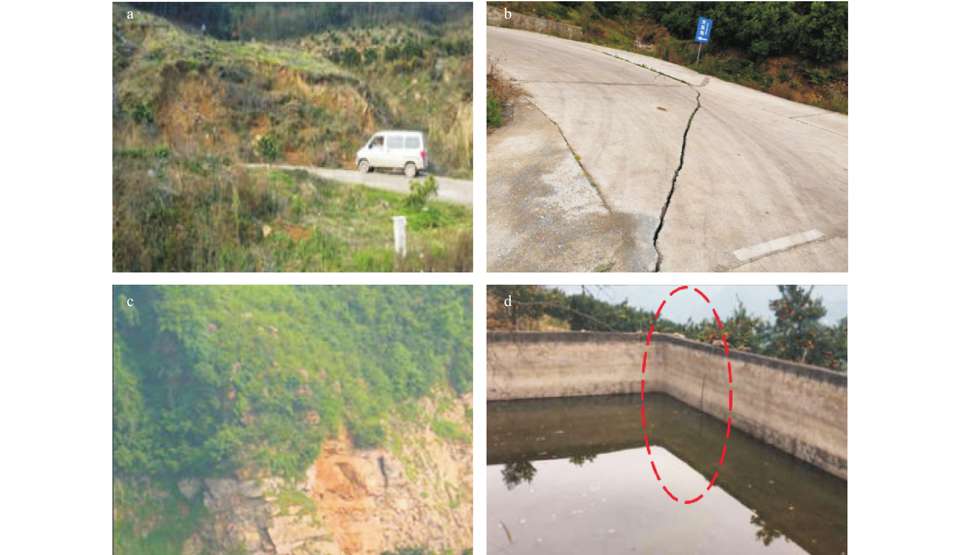
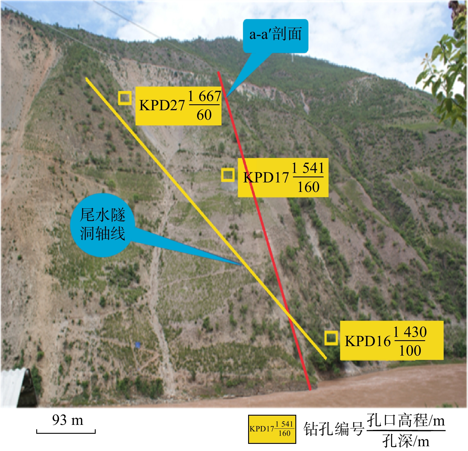
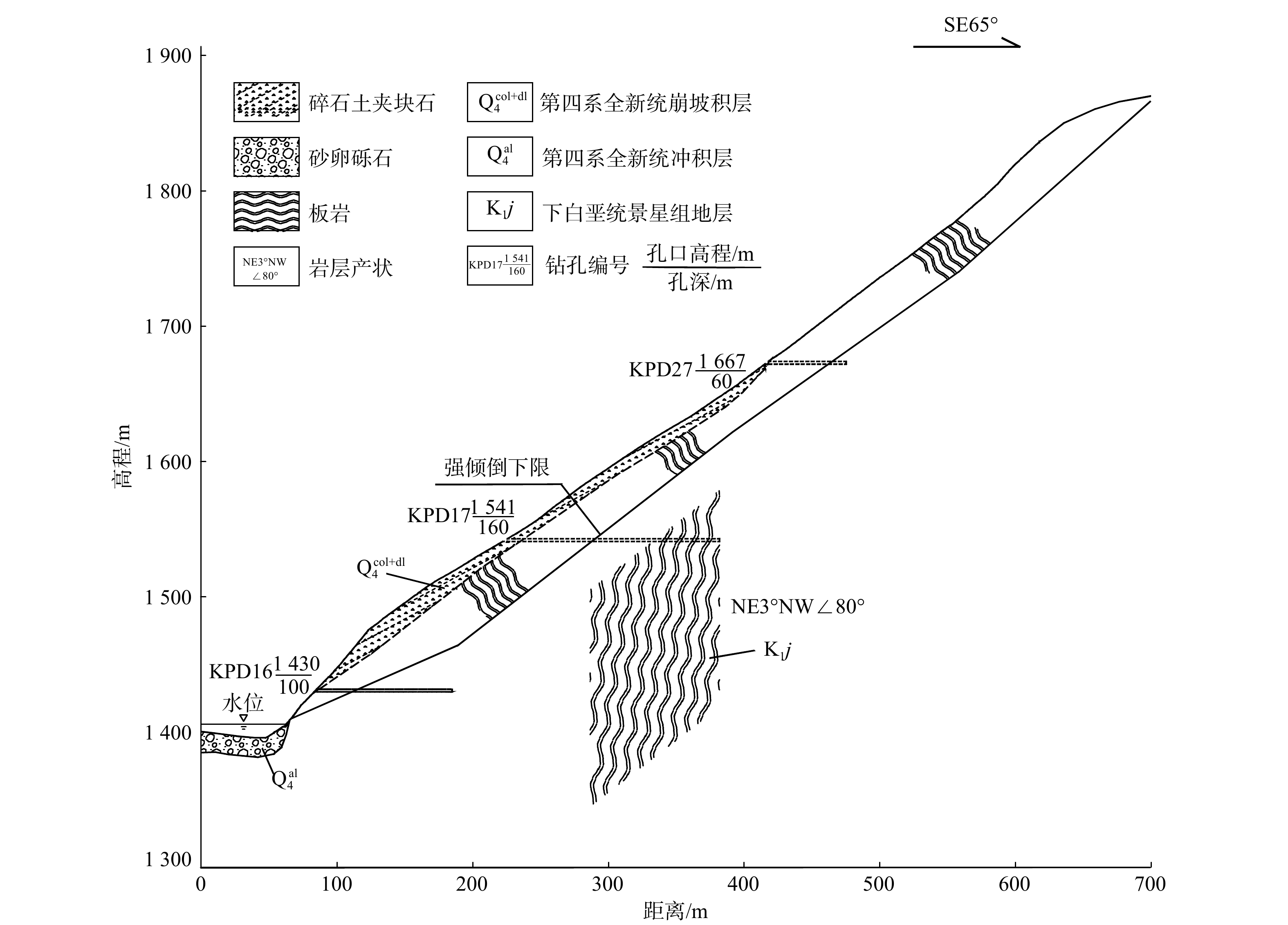
There are a large number of steep bedding rock slopes along the left bank of Dahuaqiao Hydropower Station in the middle and upper reaches of Lancang River. The unique engineering geological conditions in the reservoir area provide a good breeding environment for deformation. The landslide deposits formed by the collapse of the toppling deformed body are widely distributed in the reservoir area, which causes great difficulties for the operation and maintenance of the hydropower project. </p></sec><sec><title>Objective

In this paper, in order to study the evolution process, toppling mode, toppling deformation and failure mechanism of steep bedding rock slope,
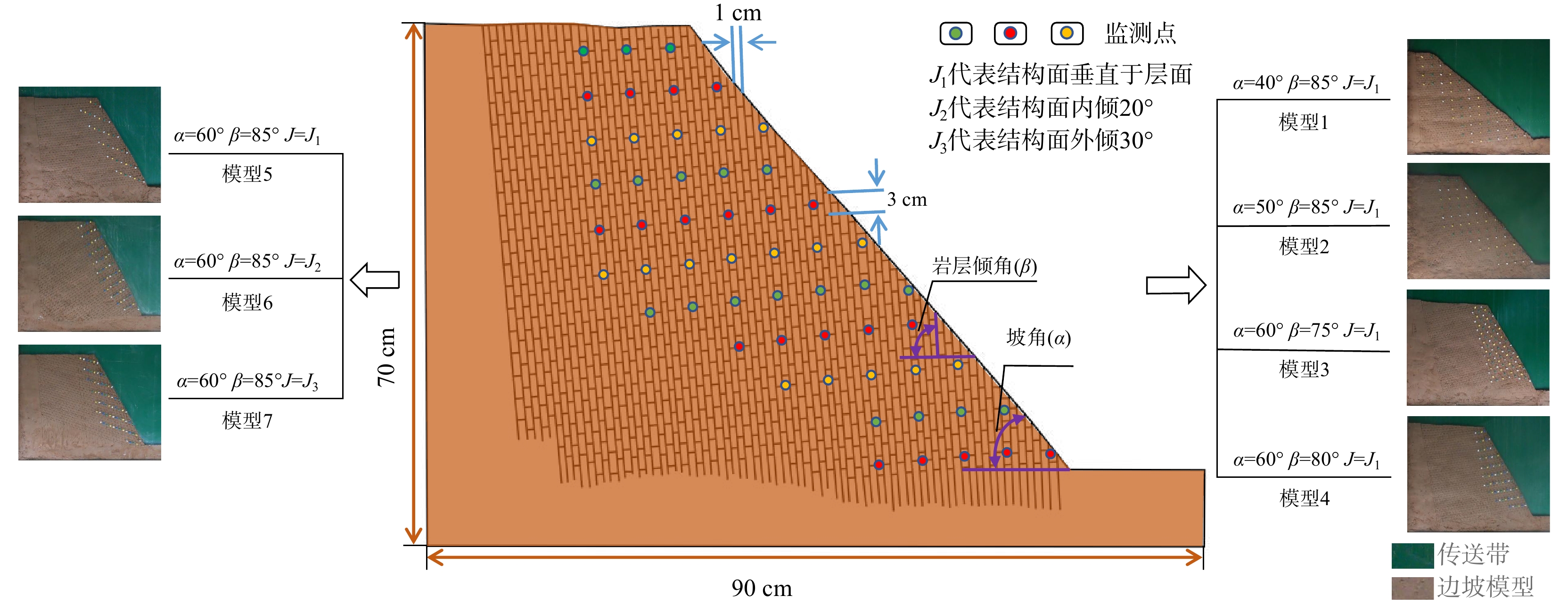
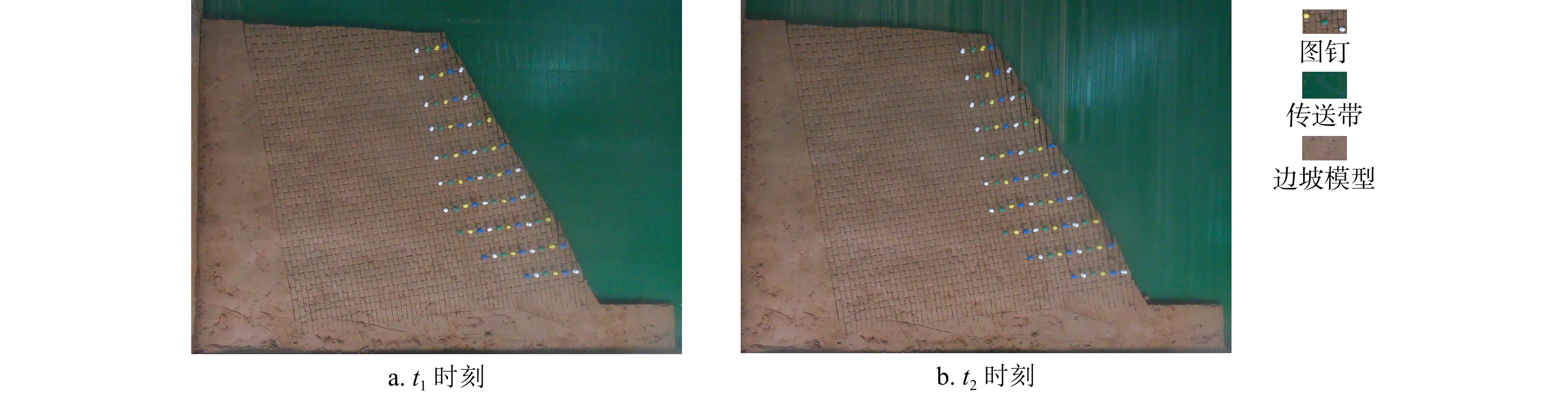
Methods

we used the slightly weathered slate on the left bank of the reservoir as a reference prototype for the similar material material, then we choose to use the bottom friction test method to analyze the deformation and failure characteristics of slope under different condition of slope angles, plane inclination angles and structural plane occurrences.
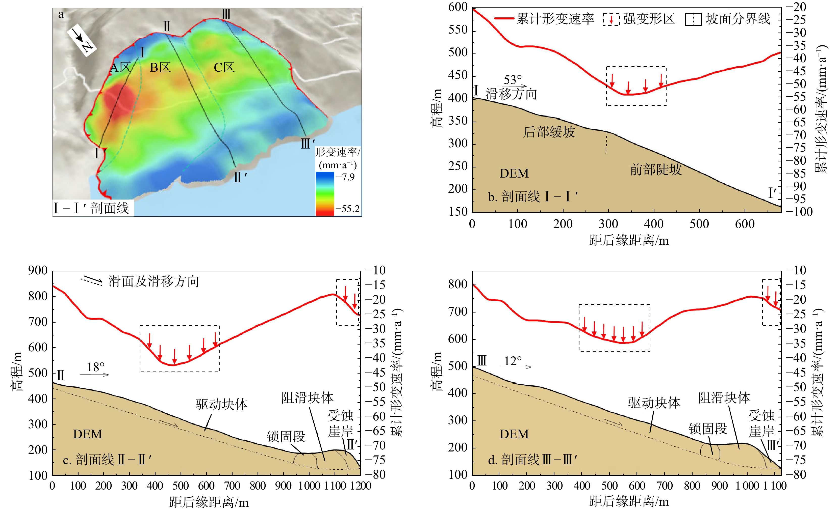
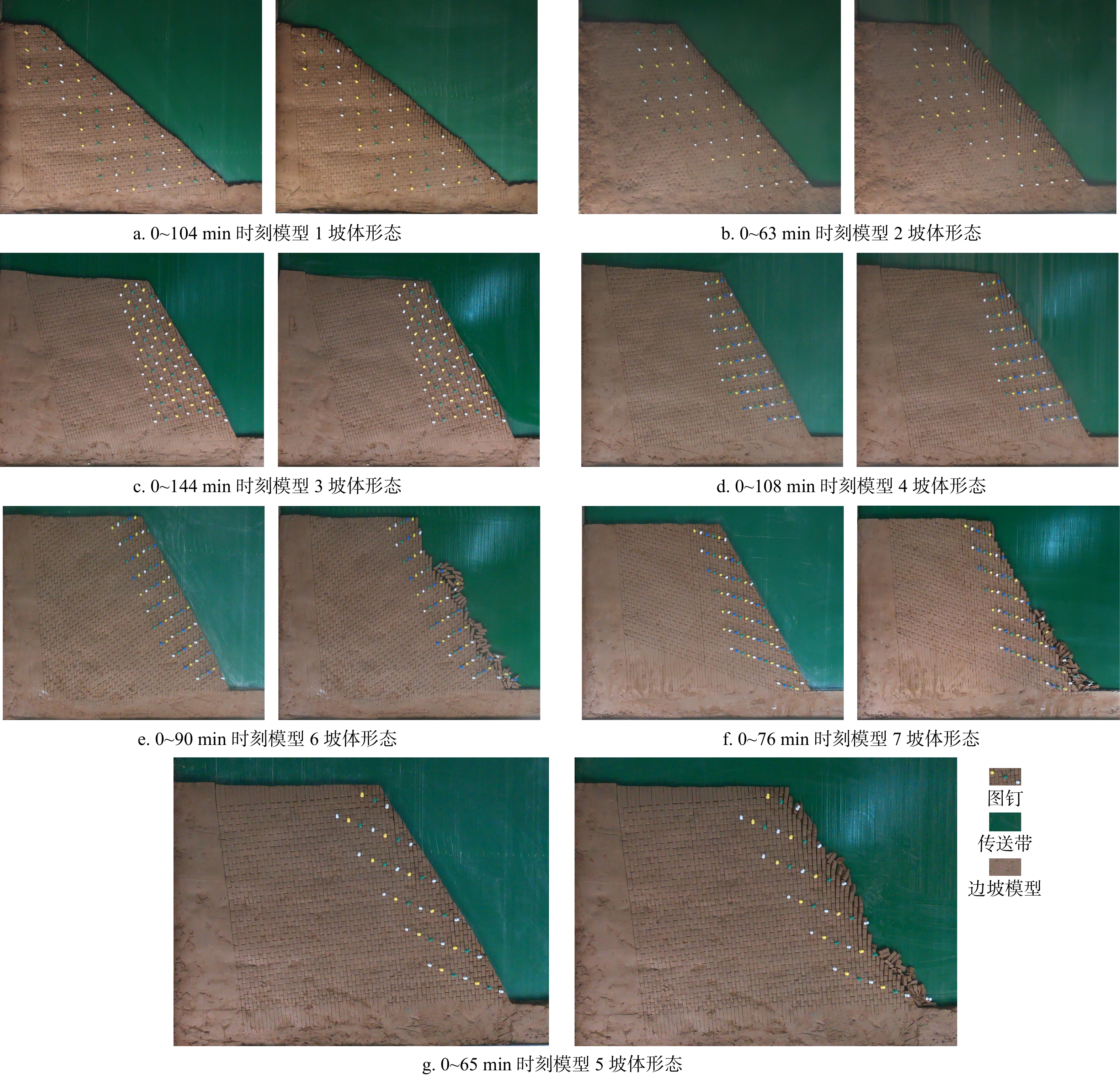
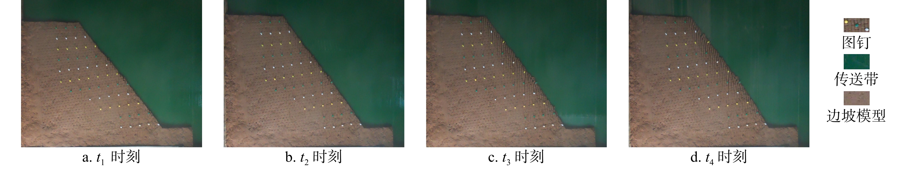
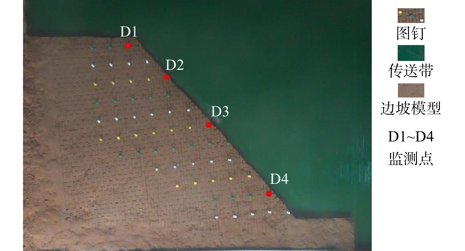
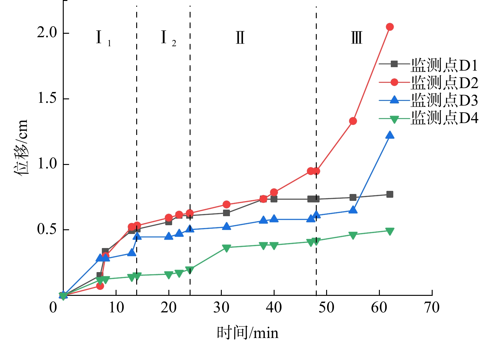
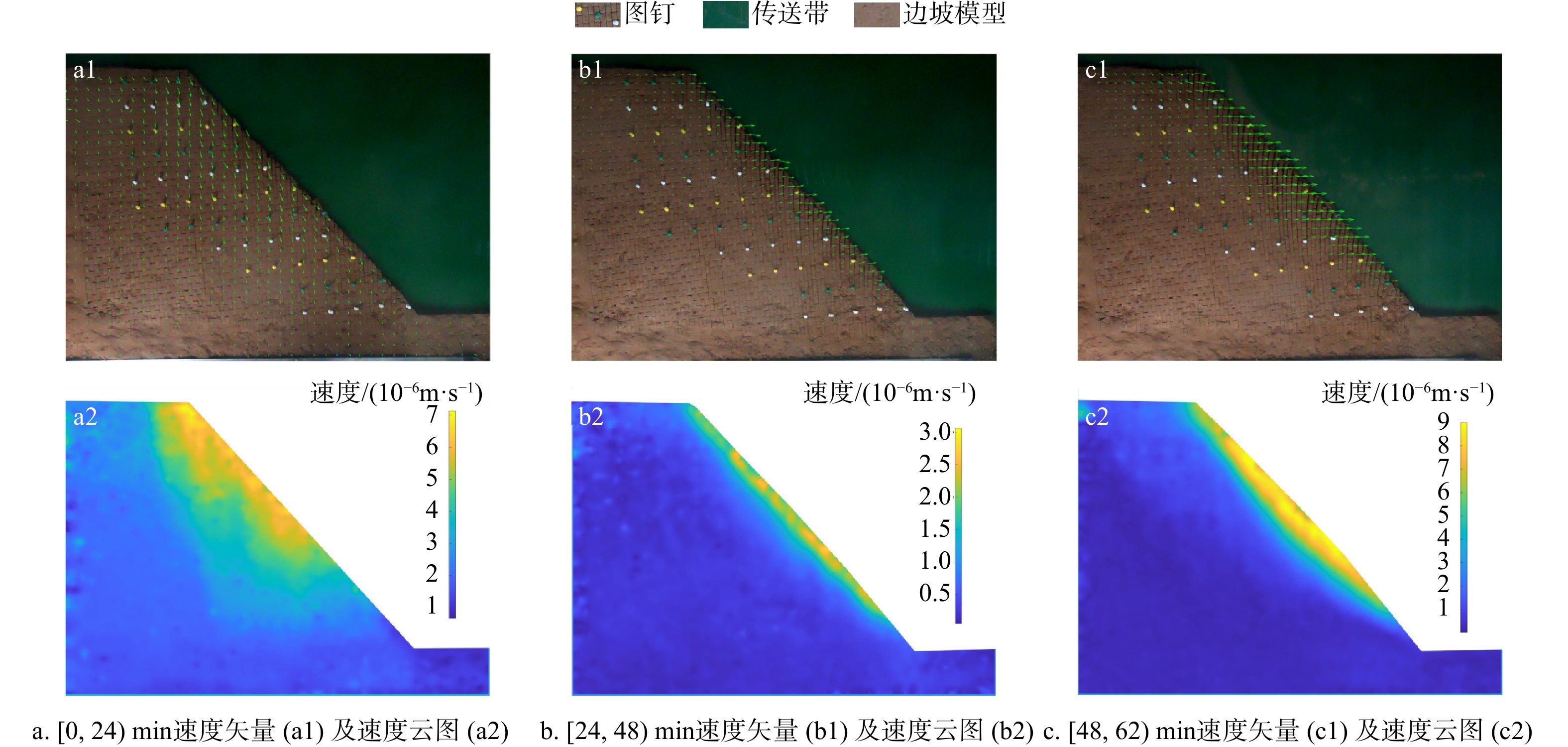
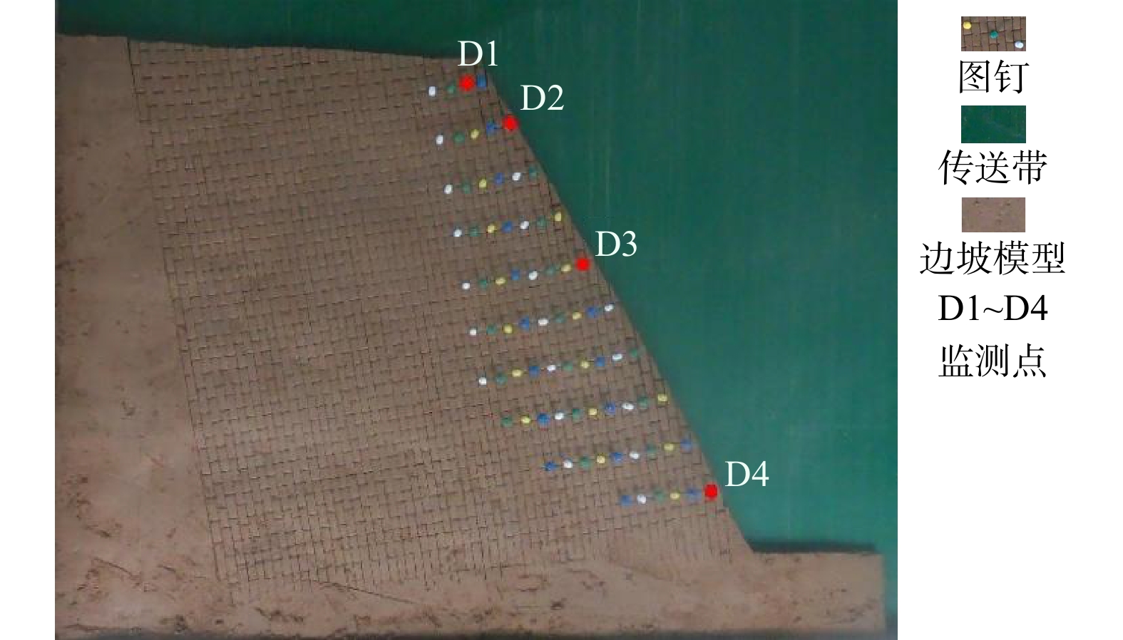
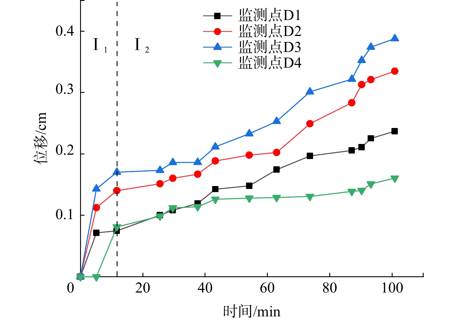
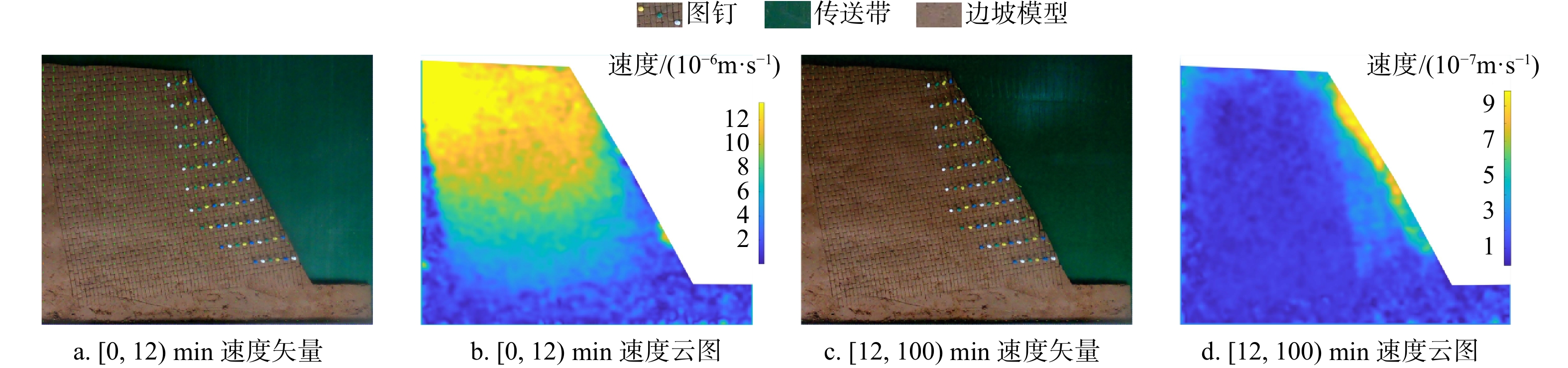
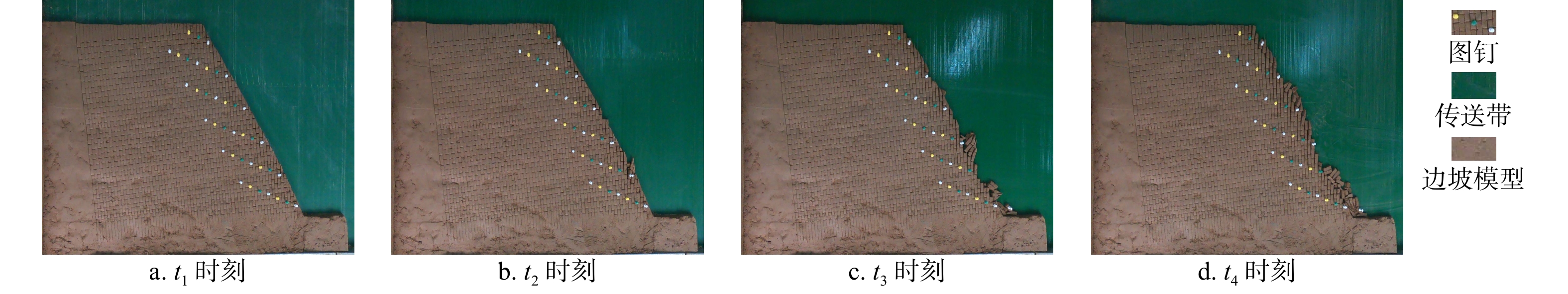
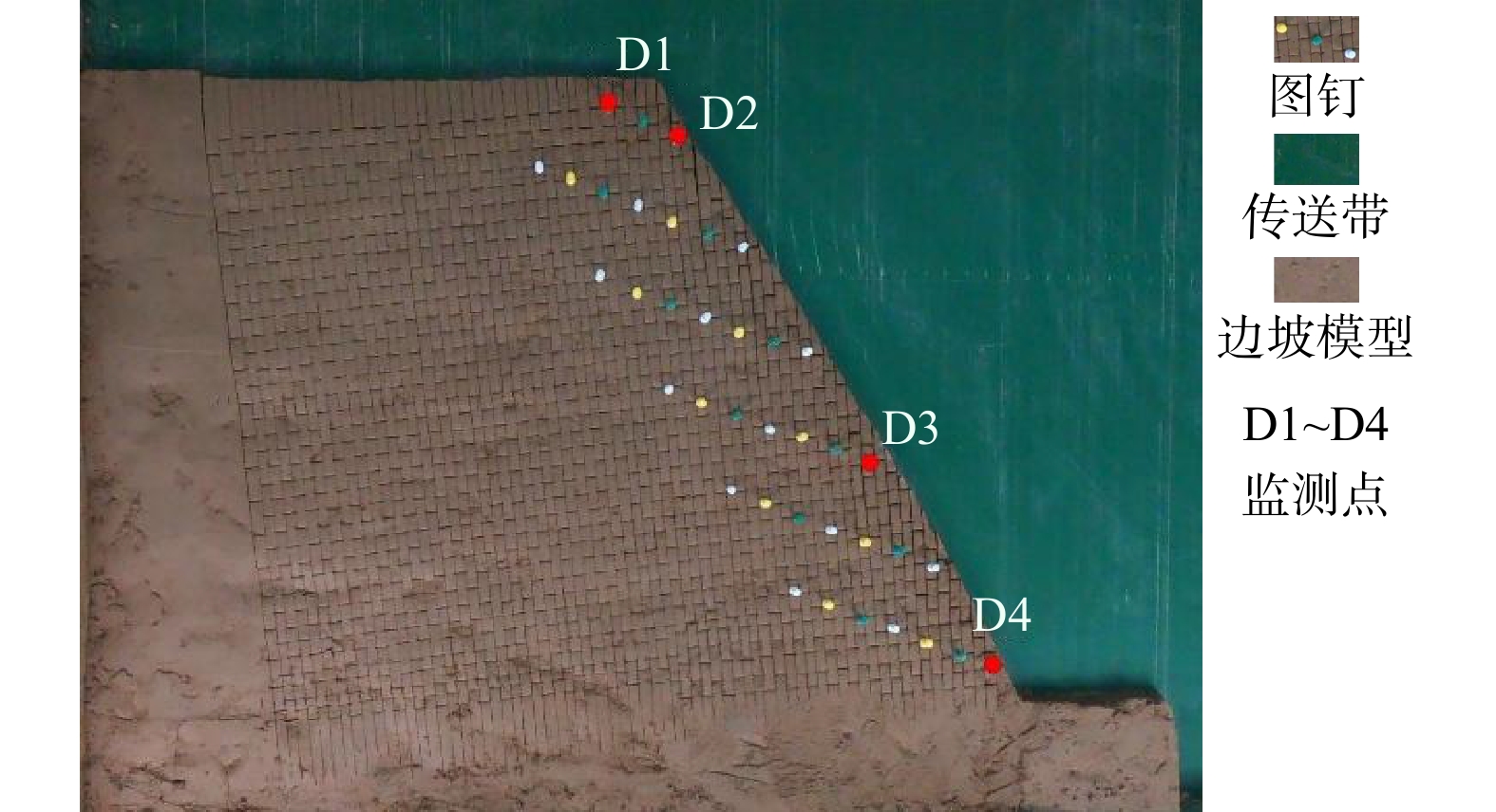
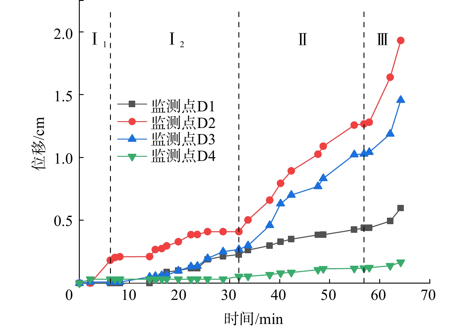
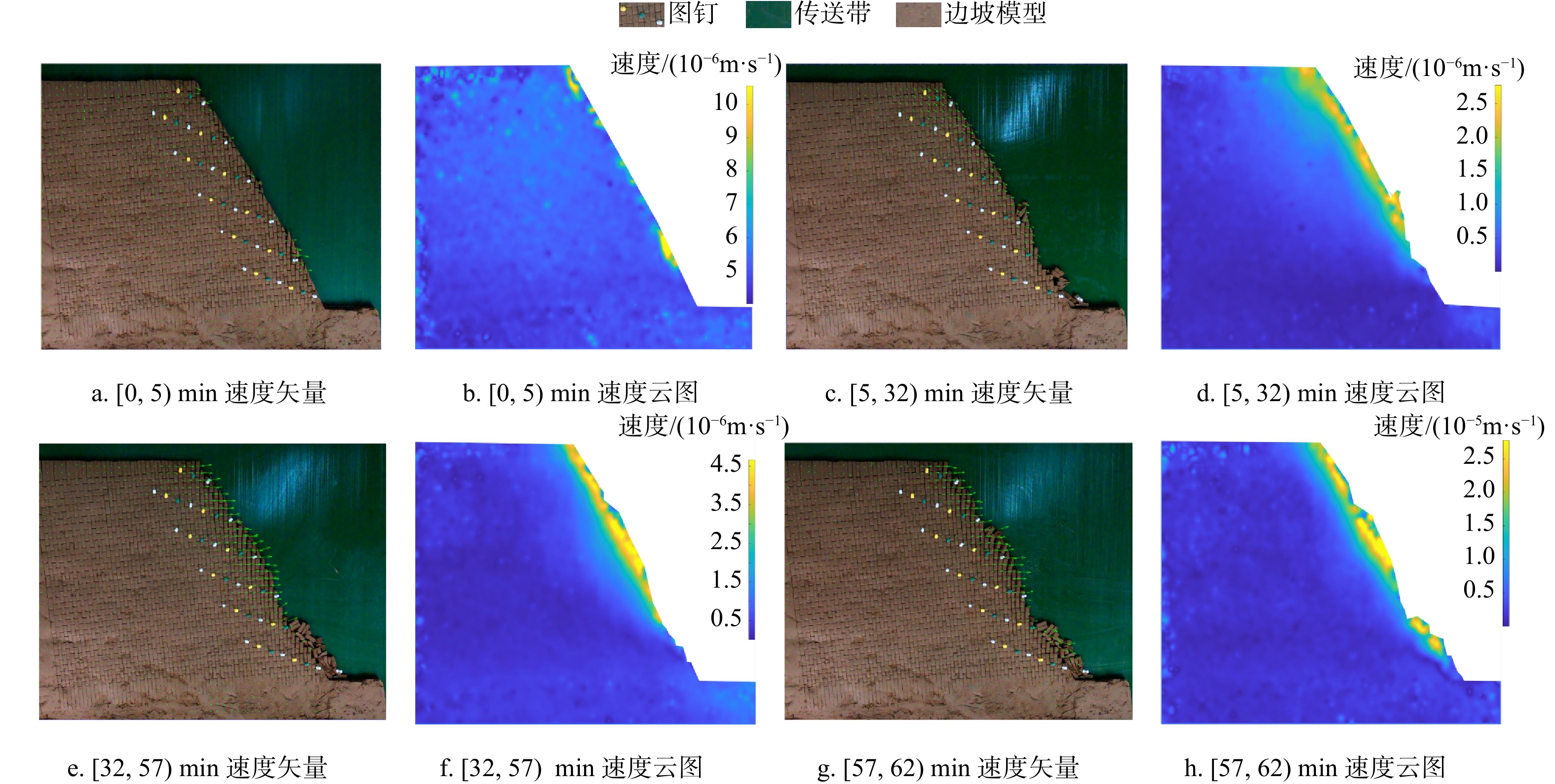
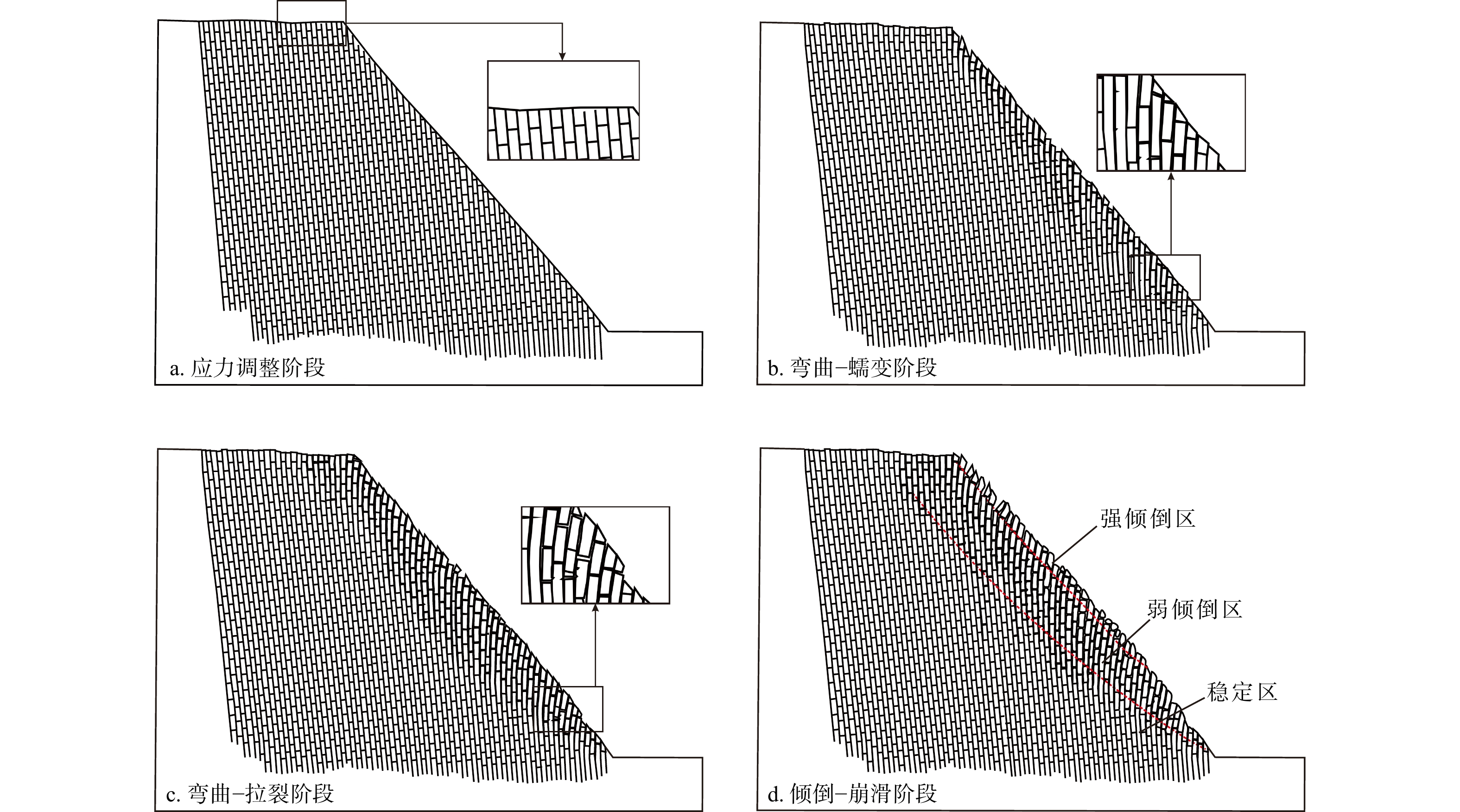
Results

The results show that: ①The main toppling failure mode of the steep bedding rock slope is the tensile-toppling type. In the early stage of evolution, the rock mass at the foot of the slope is the first to topple due to stress concentration, and gradually develops from the front edge of the slope body to the middle and back. The rock mass in the middle of the slope surface also gradually changes from the forward dip to the upright to the reverse dip state, and accelerates to bend and topple towards the free surface under the action of gravity. When the deformation of rock mass reaches a certain extent, it will fracture along the maximum bending part or structural plane, and eventually slip along the tensile fracture plane or even collapse directly. ②By comparing the slope parameters and deformation characteristics of the test models, the 7 groups of model slopes are roughly divided into 3 categories: near-vertical bedding rock gentle slope, steep dip bedding rock steep slope, near-vertical bedding rock steep slope. Compared with slope Angle, the rock layer dip Angle has more influence on the toppling deformation and failure of the steep bedding rock slope. The gently inclined structural plane that is not perpendicular to the plane is more likely to cause the toppling deformation and failure of the steep bedding slope than the one perpendicular to the plane, and the scale of toppling deformation and failure is larger when the slope body develops the inward structural plane compared with the outward inclined structural plane. ③From the perspective of deformation stage, the deformation evolution process of slope is divided into initial deformation stage, toppling deformation stage and toppling failure stage. ④The toppling deformation and failure process of steep bedding rock slope is divided into stress adjustment stage, flexural-creep stage, flexural-sliding stage and toppling-sliding-collapse fracture stage from the mechanism. According to the deformation degree of the toppling area, the deformed slope can be divided into three zones: a strong toppled zone, a weak toppled zone, and a stable zone.

Conclusion

The research results can provide reference for the research of the evolution process, toppling mode, toppling deformation and failure mechanism of steep bedding rock slope.

Deformation history analysis and movement process simulation of glacier debris flow in Sanggu Valley in southern Tibet
SUN Jingyi, YANG Jin, WU Yongning, LI Qun, ZHANG Guangcheng, ZHOU Zhesheng, XU Hongjian
2025, 44(2): 355-367. doi: 10.19509/j.cnki.dzkq.tb20240172
Abstract:
<p>Glacial debris flows in the Yarlung Zangbo River basin of southeastern Tibet are characterized by their large scale, prolonged duration, and significant societal and environmental impacts. Investigating the deformation characteristics and influencing factors of Sanggu Valley debris flow offers critical scientific insights for predicting, early warning, and mitigating glacial debris flow disasters in this region. Traditional methods often fall short in quantitatively describing the formation mechanisms of large-scale debris flows. To address this limitation, this study integrates field investigations, unmanned aerial vehicle (UAV) aerial photography, satellite imagery, and geological and meteorological data.</p></sec><sec><title>Objective

This study aims to elucidate the relationship between debris flow outbreaks in Sanggu Valley and key influencing factors, including material sources and rainfall patterns.

Methods

A novel method combining interferometric synthetic aperture radar (InSAR) and random-access mass spectrometry (RAMMS) techniques is developed to analyze the deformation process of debris flows before and during their initiation. SBAS-InSAR technology is employed to quantify the deformation of Sanggu Valley debris flow during two outbreaks, complemented by satellite images, UAV images, and field investigations. This approach enables the inversion of deformation processes and the prediction of disaster trends prior to the Sanggu Valley debris flow event. Additionally, RAMMS debris flow numerical simulation software is utilized to model the movement dynamics of the Sanggu Valley debris flow during its eruption.

Results

This study yields the following key findings: ① InSAR-derived LOS deformation analysis of the Sanggu Valley debris flow reveals the prolonged slope creep, with maximum deformation rates of 139 mm/a in the source area, 46 mm/a in the flow area, and 20 mm/a in the accumulation area. Rainfall is identified as a critical factor in supplying loose materials for debris flow development. ②The evolution process of the debris flow is categorized into three stages: initial motion, accelerated motion, and deceleration.

Conclusion

The proposed methodology, which integrates historical deformation analysis and numerical simulation of glacial debris flow dynamics, provides a scientific foundation for predicting debris flow development trends and designing effective engineering control measures.

Prediction model of groundwater microbiological toxicological indicators in alpine regions based on LM-BPNN
JIA Zhuopeng, BI Junbo, YUAN Yong, QUAN Xin, WANG Shuaiwei, SUN Weichao
2025, 44(2): 368-377. doi: 10.19509/j.cnki.dzkq.tb20240345
Abstract:
Objective

To establish a prediction model for groundwater microbial toxicological indicators (total bacteria count [TBC] and total coliform count [TCC]) in alpine regions,

Methods

this work focuses on the microbial toxicity indicators (TBC and TCC) of groundwater from a specific water source in the western plateau region of China. By using an orthogonal experimental design combined with indoor soil column batch experiments, we varied environmental factors such as pH, temperature, and porosity to obtain the evolution results of TBC and TCC under different depths, pH values, oxidation-reduction potential (ORP) values, temperatures, porosities, and chemical oxygen demand (COD) conditions. On the MATLAB platform, a predictive model for microbial toxicity indicators in groundwater in frigid regions was subsequently established using the LM (Levenberg Marquardt)-optimized BPNN (neural network) algorithm.

Results

These results indicate that the predictive results of the established TBC and TCC models align well with the experimental results. The maximum relative errors are less than 15% (meeting engineering requirements), yielding 11.52% and 14.55% for TBC, and TCC, respectively. Moreover, the evolutionary trends of TBC and TCC match the experimental results.

Conclusion

This model can be used for predicting microbial toxicity indicators in groundwater in plateau regions, and the results of this study provide new insights for predicting microbial toxicity indicators in groundwater in high-elevation areas.

Spatial evolution of hydrogeochemistry driven by river water-groundwater transformations in the Manas River Basin
MA Wenjing, WANG Wenke, HOU Xinyue, JI Deshuai, MA Zhitong
2025, 44(2): 378-388. doi: 10.19509/j.cnki.dzkq.tb20240360
Abstract:
Objective

The mutual conversion between river water and groundwater plays a crucial role in influencing the composition and evolution of hydrochemical components, and thus, has a significant impact on the water ecological environment. Hence, it is critical to gain a comprehensive understanding of the sources and evolution mechanisms of its hydrochemical components. The complex interactions between river water and groundwater can lead to alterations in the chemical constituents, which may have far-reaching consequences for the overall health and stability of the aquatic ecosystem.

Methods

This work focused on the Manas River Basin, which is located in a typical arid area of China, as the research area. A series of advanced methods were involved in this work, including hydrochemical diagrams (provide a visual representation of the chemical characteristics); ion ratio coefficient analysis (helps in determining the relative proportions of different ions); and inverse hydrogeochemical evolution (allows for a detailed exploration of the historical changes in the water chemistry). Through these methods, an in-depth study is carried out on the hydrochemical characteristics of river water and groundwater in different landforms within the basin, as well as the sources of major ion components and the evolution laws.

Results

These results obtained from the research are highly revealing. It is found that with the changes in landforms and the conversion relationship between river water and groundwater, the hydrochemical types of river water and groundwater experience a progressive evolution. Initially, they are mainly of the HCO3·SO4-Ca type, but gradually transform into the Cl-Na type. The natural driving factor responsible for these hydrochemical changes also shifts. In the disconnected segment, the hydrochemical type of water bodies is predominantly HCO3·SO4-Ca, and the main influencing factor is diafiltration. In the upper reaches of the river-groundwater exchange section, it is mainly SO4·Cl-Na type water, where leaching and mixing are the dominant processes. In the lower reaches of the interaction section, the hydrochemical type is mainly Cl-Na, which is dominantly affected by evaporation. The results of inverse evolution further quantitatively analyze the influence of water-rock interaction in the research area. Along the direction of groundwater flow, specific chemical reactions occur. For example, the precipitation of albite and anorthite takes place, while the dissolution of dolomite, gypsum, Ca-montmorillonite and rock salt is observed. Additionally, positive cation exchanges of Na-Mg and Ca-Mg are also detected.

Conclusion

The results of the study can provide a scientific basis for water environment protection and sustainable management in arid and semi-arid regions.

Transformation of Cr(Ⅲ) in different redox environments
LI Gang, WANG Cong, XIE Kefeng, WEI Xiaoya, NIU Hong
2025, 44(2): 389-400. doi: 10.19509/j.cnki.dzkq.tb20240407
Abstract:
Objective

It is still unclear about the effects of redox fluctuations by Fe(Ⅱ)-containing clay minerals on the adsorption-desorption and valence transformation of Cr(Ⅲ).

Methods

In this work, Cr(Ⅲ) adsorption experiments were carried out by preparing montmorillonite in three different conditions (oxidized, reduced, and reduced-reoxidized) to determine the adsorption value, Fe(Ⅱ)/total Fe ratio, hydroxyl radical concentration, as well as valence changes. The montmorillonite solid materials before and after adsorption were characterized via X-ray photoelectron spectroscopy (XPS), X-ray diffraction (XRD), and Fourier transform infrared (FTIR).

Results

The results revealed that the adsorption rate of Cr(Ⅲ) by oxidized and reduced montmorillonite increased with elevated pH, and that reduced montmorillonite had the highest adsorption rate due to its highest Fe content, with no valence change occurring in these two states. The adsorption rate of reduced-reoxidized montmorillonite was the lowest, which was due to the rapid activation of oxygen by Fe(Ⅱ), producing hydroxyl radicals. Cr(Ⅲ) was rapidly oxidized to Cr(Ⅵ), and the lower the pH, the higher the oxidation rate. Cr(Ⅵ) was reduced back to Cr(Ⅲ) by the reducing substance Fe(Ⅱ) after 8 hours. The high correlation between the consumption rate of Fe(Ⅱ) and the generation rate of hydroxyl radicals was verified by changes in the Fe(Ⅱ)/total Fe ratio and hydroxyl radical concentration, which altered the redox environment.

Conclusion

Experiments have shown that hydroxyl radicals are generated after reduction and reoxidation, which affects the adsorption and desorption of Cr(Ⅲ), and strongly oxidizing hydroxyl radicals can oxidize Cr(Ⅲ) to toxic Cr(Ⅵ), supporting the hypothesis that chromium reverts to yellowish color after redox fluctuations in the underground environment.