2023 Vol. 42, No. 2

Display Method:
Geochemical characteristics of the primary halo in boreholes and prospecting prediction of the Banchang Cu-Mo polymetallic deposit in Henan Province
Yao Juan, Zhang Xiaoxu, Lu Shengyuan, Chen Lei, Qin Lei
2023, 42(2): 1-10. doi: 10.19509/j.cnki.dzkq.2022.0261
Abstract:

The Banchang Cu-Mo polymetallic deposit is located in the middle section of the Zhuyangguan-Xiaguan regional fault, the North Qinling fold belt of the eastern Qinling orogenic belt. It is the first large copper deposit discovered in Henan Province. In the presurvey and general prospecting, a drilling workload of 23 600 meters was invested successively, extending the prospecting depth of the copper belt in Banchang by nearly kilometers, and the maximum thickness of the main ore body is 285.95 m. By systematical samples from 23 drilling holes of the No.220 to No.76 exploration line in the Banchang Cu-Mo polymetallic deposit, the primary halo characteristics were preliminarily studied. The geochemical primary halo obtained from the No.172 exploration line with the most construction drilling holes reveal the fluid transport channels. The study confirmed the zoning characteristic of fluid migration and mineralization-"Cu first and then Mo", and the vertical primary superimposed halo established by the Gregorian zoning index method is Sb-AS-Pb-Bi-Zn-Ag-Sn-Cu-W-Au-Mo in the mining area. Combined with the spatial distribution of ore bodies in the No.172 exploration line, four zonal indexes were further established as indicators for evaluating the spatial location of concealed ore bodies. All these factors provide a geochemical basis for deep prospecting.

Characteristics of bitumen in sandstone-type copper-rhenium deposits in the Mishi Basin, Xichang, Sichuan Province, and its relationship with copper and rhenium enrichment mineralization
Chen Bangqiao, Liang Bin, Hao Xuefeng, Tang Yi, Pan Meng, Peng Yu
2023, 42(2): 11-18. doi: 10.19509/j.cnki.dzkq.2022.0175
Abstract:

The Mesozoic Mishi continental basin in the Xichang District, Sichuan Province, is located on the western margin of the Yangtze Craton. Rhenium associated with sandstone-type copper ore has recently been discovered in the Lower Cretaceous Feitianshan Formation (K1f) in the basin. Copper-rhenium ore bodies are found in fragmented, lenticular sandstones of the Feitianshan Formation. Numerous fine-veined bitumen could be found in the ore. To explore the effect of organic matter (bitumen) on copper-rhenium mineralization in sandstone copper-rhenium deposits (spots) in the Mishi Basin, the ore and bitumen in the deposits (spots) were studied on mineralography, microstructure, infrared spectroscopy and isotope composition of organic carbon. The results show that the copper minerals occur in the bitumen as anhedral grains and display athel metasomatic structure. The bitumen has high Cu and Re contents and is formed by thermal cracking in the ancient oil reservoir in the Lower Triassic Baiguowan Formation. The formation of the copper-rhenium deposit has a close spatial and genetic relationship with the organic matter of the ancient oil reservoir. This type of deposit provides a new object for the study of super-enrichment of rhenium and other dispersed elements.

Prospecting model and metallogenic prediction of the Jinchangzi gold deposit in the Weiningbeishan area, Ningxia
Hai Lianfu, Tao Rui, Zhang Xiaojun, Liu Anlu, Liu Jinke, Wei Junhao, Bai Jinhe, Li Haifeng
2023, 42(2): 19-32. doi: 10.19509/j.cnki.dzkq.2022.0250
Abstract:

The Weiningbeishan area in the eastern section of the North Qilian orogenic belt is one of the areas with the best metallogenic conditions and the most metallogenic signs of gold polymetallic deposits in Ningxia. In recent years, the Jinchangzi gold deposit is one of the breakthroughs in exploration work in this area. Based on the previous data, this paper summarizes the ore-controlling factors and prospecting indicators of the Jinchangzi gold deposit. A multielement comprehensive prospecting model based on geological-geophysical-geochemical prospecting was constructed, and the mining area and surrounding prospecting target areas were delineated. The research shows that the ore-controlling factors of the Jinchangzi gold deposit are mainly stratigraphic and structural. Stratigraphic factor is mainly manifested in specific strata and lithological combinations, and structural factor is mainly controlled by east-west regional faults and their secondary fissures. Hematitization-limonitization, silicification, sericitization, pyritization, jarosite alteration and other surrounding rock alterations, Au-Ag-As-Sb geochemical anomalies, and medium resistivity and medium-high polarizability anomalies are the main prospecting indicators in this area. Based on ore-controlling factors and prospecting indicators, a comprehensive gold prospecting model suitable is proposed for this area. 6 prospecting target areas and 3 deep prospecting target areas are delineated based on this model. Through the geochemical profile and the deep drilling of the target area, the rationality of target area has been confirmed, providing a well tool for future prospecting work in this area.

Analysis of mineralogical characteristics of imported iron ore from different countries: Constraints from maceral compositions and elemental analysis
Zhang Ziao, Liu Entao, Xu Jiaxing, Yan Detian, Liu Shu, Min Hong
2023, 42(2): 33-40. doi: 10.19509/j.cnki.dzkq.2021.0094
Abstract:

China is the largest importer of iron ore resources. Analyzing the mineralogical characteristics of imported iron ore samples imported from different countries can provide a reference for identifying the source of iron ore and solid waste attributes. In this paper, iron ore samples imported from 11 countries were used to determine their elemental compositions and mineral assemblages by polarized light microscopy investigation, X-ray fluorescence spectroscopy (XRF) and pyrite/magnetite LA-ICP-MS element analysis. These results are applied to explore the formation environment of iron minerals. XRF analysis results show that the main elements of iron ore samples are Fe and O, followed by Si, Ca, Al, Mn, Tb, Ti, Mg, P, and S. These elements are significant differences in iron ore among different countries. Polarizing microscopy investigation shows that there are great differences not only in mineral types but also in other aspects (e.g., accessory mineral types, accessory mineral content, and structure). These differences can be used as proxies for the identification of iron ore origin. Finally, in situ major and trace elements of magnetite were used to distinguish the genetic types of iron deposits. The magnetite deposits from Burma and Laos are skarn type, while those from Australia are mainly BIF type. In this study, multiple techniques were used to characterize the differences in element content, mineral facies composition and mineral-forming environment of iron ore samples and to comprehensively analyze the mineralogical characteristics of iron ore samples from different countries. These differences are of great significance for the identification, quality control and origin of imported iron ore resources.

Genesis of silica-rich carbonatite in the Miaoya complex, Hubei Province and its implications for REE mineralization
Hu Yinqiu, Wu Bin, Ren Qian
2023, 42(2): 41-59. doi: 10.19509/j.cnki.dzkq.tb20220183
Abstract:

The Miaoya complex in Hubei Province hosts one of the most important REE deposit in China. This complex is composed of syenite, carbonatite (SiO2 < 10%), and a suite of silica-rich carbonatite (SiO2>30%). The petrology and mineralogy of silica-rich carbonatite were investigated by the electron probe microanalyzer (EPMA), X-ray fluorescence spectrometer (XRF), laser ablation inductively coupled plasma mass spectrometer (LA-ICP-MS) and other analytical methods, aiming to decipher the genesis and potential REE mineralization of silica-rich carbonatite from the REE ore bodies in carbonatite. First, silicate minerals of silica-rich carbonatite are dominated by K-feldspar, albite and quartz, which is similar with associated syenite, rather than adjacent Silurian Meiziya Group schist. This suggests that these silicate minerals are probably xenocrystals from syenite. Second, the captured K-feldspar in silica-rich carbonatite has irregular compositional zoning and higher Sr isotopes compared to marine sediments, implying the presence of postmagmatic fluid activity. In addition, the Th-Pb age of hydrothermal monazite associated with silicate minerals in silica-rich carbonatite yields (235.1±1.5) Ma, suggesting that this fluid activity is probably related to the regional metamorphic event related to the closure of the Mianlue Ocean (246-221 Ma) during the collision between the North China Craton and the Yangzi Craton. During the postmagmatic stage, Si and REEs are remobilized from silicate xenocrystals and fluorapatite into fluids, respectively. Moreover, Si in fluids could promote REE transport by these Sr-Ba-Si-rich fluids and ultimately lead to relatively low REE contents in these silica-rich carbonatites.

Characteristics of igneous rocks and their significance in hydrocarbon accumulation in Block C of Santos Basin, SE Brazil
Zhao Jian, Zhang Jie, Zhao Junfeng, Ren Kangxu, Wang Chaofeng, Guo Yuan
2023, 42(2): 60-68. doi: 10.19509/j.cnki.dzkq.tb20210489
Abstract:

Santos Basin is characterized by multiple phases of magmatic events and widespread distribution of igneous rocks, which have significant affect of hydrocarbon accumulation. Taking Block C of Santos Basin as a typical and representative example, this paper focused on the characteristics of igneous rocks and their roles in hydrocarbon accumulation through the analysis of igneous rock petrology, geochronology, petrogeochemistry, and gas isotopes. In Block C, at least two main stages of magma events were developed: Aptian magma (122.8±0.6-110.8±0.6 Ma) and Santonian-Campanian magma (84.2±0.7-77.4±0.4). The Aptian magma is dominated by eruptive rocks and has experienced dozens of eruptions, accompanied by several layers of subvolcanic rocks. In comparison, Santonian-Campanian magma is distributed in a relatively random pattern. The multipulse eruption of Aptian magma formed an igneous rock-coquinas complex of more than 600 meters in thickness, inducing a local paleohigh in Itapema Formation. This directly caused the trap crest to shift and contributed to the development of high-quality carbonate deposition in Barra Velha Formation. Before the eruption of Aptian magma, the north flank of Block C was paleohigh, where a particular scale of microbial carbonate reservoirs was anticipated to develop in the Barra Velha Formation as well. These carbonate reservoirs were favorable for hydrocarbon accumulation. The later Santonian-Campanian intrusions also impact carbonate reservoirs through hydrothermal fluid circulation and contact metamorphism. Meanwhile, a large amount of associated CO2 accumulated in the trap led to a high GOR (gas oil ratio) and high CO2 content and changed the fluid composition through the extraction process.A CO2 gas reservoir with condensed oil was eventually formed in the current crest in Block C, as proven by drilled well A.Another pool with high CO2 content is also expected in its north flank, to be demonstrated in the future.

Characteristic analysis of deep water gravity flow sediments in Ch6-Ch7 Section of Yanchang Formation in the Binchang Block, southern Ordos Basin, China
Xiao Gaojian, Luo Yang, Liu Hongping
2023, 42(2): 69-82. doi: 10.19509/j.cnki.dzkq.2022.0135
Abstract:

Massive sandstone without sedimentary structure is developed in the Ch6-Ch7 Section of Yanchang Formation in the Binchang Block, Southern Ordos Basin, which has a good oil and gas show, good productivities and good exploration and development prospect. However, the formation mechanism of the sandstone is still in dispute. It is of great significance to determine the sedimentary facies and sedimentary model of the sandstone in Ch6-Ch7 Section in order to analyze the formation mechanism of sweet spot in the low permeability sandstone reservoirs, to predict the sweet spot distribution model and guide the subsequent exploration and development. In this paper, 15 lithofacies and 3 main types of sedimentary microfacies, namely, sandy debris flow, turbidite and seismite slump microfacies, have been identified by using a large amount of core sedimentary description data, grain size analysis data and geological mapping analysis, and these three kinds of sedimentary assemblies in space. The deep water gravity flow deposition model in the Ch6-Ch7 Section can be summarized as the sublacustrine fan model and can be divided into three subfacies or assemblies: the upper fan subfacies dominated by the assembly of seismite-slump and sandy debris flow, the mid-fan subfacies dominated by the assembly of the sand debris flow-turbidite microfacies and the lower-fan subfacies dominated by turbidite flow-basin plain microfacies assembly.

Characteristic and petroleum geology of the Mesozoic sags of the northern Qiongdongnan Basin
Zhu Jitian, Yang Xibing, Hu Xiangyang, Luo Wei, Li Yong, Mao Xuelian, Feng Shixin
2023, 42(2): 83-93. doi: 10.19509/j.cnki.dzkq.2022.0219
Abstract:

Mesozoic sags of the Qiongdongnan Basin are prospective areas for oil and gas discovery. To make petroleum breakthroughs in Mesozoic sags in the Qiongdongnan Basin, it is urgent to clarify the conditions of hydrocarbon accumulation and the favorable areas for exploration in those Mesozoic sags. Based on geophysics, geochemistry, drilling and paleontology data, systematic research on Mesozoic sags in the Qiongdongnan Basin was carried out. The results show that Mesozoic sedimentary formations were distributed in the Yabei Sag, Yacheng Uplift, Yanan Uplift, Lingnan Uplift and Southern Massif in the Qiongdongnan Basin. According to the analysis of tectonic evolution, Mesozoic formations were formed in the back-arc extensional basin in the Yanshanian period with subduction of the Pacific Plate to the Eurasian Plate, which has the possibility of forming source rocks, reservoirs, and traps. Because the potential of Mesozoic sags is larger in the Yacheng-Yabei area of the northern depression than in other areas in the Qiongdongnan Basin, this paper focuses on the comprehensive study of petroleum geology in the Yacheng-Yabei area that includes the definition of the Mesozoic formation and defines the favorable area and prospects of Mesozoic rocks. This paper further notes that Mesozoic lacustrine source rocks, delta reservoirs, structural and stratigraphic traps developed in the Yacheng-Yabei area. The southern slopes of the western sag and central massif are two favorable areas for exploration. To expand exploration in these areas, we hope to make petroleum breakthroughs in Mesozoic formations.

A modeling method of channel sand based on deep generation models
Gao Xiaoyang, He Wenxiang, Hu Yong
2023, 42(2): 94-104. doi: 10.19509/j.cnki.dzkq.2022.0208
Abstract:

In traditional channel sand body modeling methods, the method based on target modeling is difficult to condition, and multipoint geostatistics have difficulty reproducing the shape of continuous channel sand bodies, which makes the modeling results difficult to directly apply to oilfield production. Through depth learning, the depth generation model can generate a sufficiently accurate channel sand body model, reproduce the complex channel sand body shape, meet the well point conditions, and compensate for the shortcomings of the traditional modeling algorithm. In the process of modeling, 20 000 channel sand body models and corresponding condition sets are established based on the target simulation method and computer matching operation. Combined with the theory of variational autoencoders (VAE) and generative adversarial networks (GAN), a depth generation model is established, including a classifier, encoder, decoder and discriminator. The condition data and the real model are input into the depth generation model to obtain the corresponding channel sand body model. Through extensive training, a generator that can generate channel sand bodies that meet the well point conditions is established. Finally, the well point data are input into the generator to establish the corresponding channel sand body model. The results show that compared with the traditional modeling algorithm, the depth generation model modeling algorithm not only shows a continuous and clear channel sand body but can also generate multiple channel sand body models under given conditions. This modeling method overcomes the shortcomings of traditional channel sand modeling methods and provides a new solution for channel sand reservoir modeling. The established channel model can provide a reference for the oilfield development stage.

Characteristics and controlling factors of tight sandstone reservoir fractures in the Xujiahe Formation of the western Yuanba area, northeastern Sichuan Basin
Huang Yanqing, Xiao Kaihua, Jin Wujun, Wang Ai, Liu Zhiyuan, Wang Ruyue
2023, 42(2): 105-114. doi: 10.19509/j.cnki.dzkq.2022.0099
Abstract:

The Xujiahe Formation in the western Yuanba area of the northeastern Sichuan Basin was slightly affected by late tectonic activity and thus has fewer fractures relative to the central and eastern Yuanba areas. Utilizing core observation, slice identification, logging interpretation, and inclusion analysis, the characteristics and controlling factors of fractures in tight sandstone of the Xujiahe Formation of the western Yuanba area were analyzed.The results show that the study area mainly contains low-angle shear fractures and diagenetic fractures. Fractures in the 2nd and 3rd members of the Xujiahe Formation were primarily filled by calcite and clay respectively. The fractures in the Xujiahe Formation of the study area can be classified into three stages, corresponding to the regional tectonic deformations during the Late Jurassic, the end of the Early Cretaceous, and the Late Himalayan. The fractures of the 1st and 2nd stages were fully or partly filled, but the 3rd stage fracture was not filled. The development of fractures was mainly affected by the fault and fold deformation strength, lithology combination, and stratum thickness. Fractures in the hinge zone and southeast limb of Jiulongshan anticline were mainly generated by bending deformation except for the fault zone. The fault-related fracture was more plentiful in the vicinity of the fault zone. Both bending deformation fracture and fault-related fracture are favorable for petroleum development. Fractures in the conglomerate of 3rd Member of the Xujiahe Formation can terminate at or transect the gravel particle and generally show small apertures. The low-angle fractures and micro-fractures in the quartz sandstones of the 2nd Member of the Xujiahe Formation developed aligning with bedding. Both the 3rd and 2nd members of the Xujiahe Formation in the study area are favorable targets for petroleum exploration and development.

Logging identification of high-quality shale of the marine-continent transitional facies: An example of the Shan 2 Member of the Daning-Jixian area in the Ordos Basin
Shi Biao, Wu Feng, Li Shuxin, Liang Yun, Xi Yanping, Dai Jin, Shi Xiangchao, Zhao Hui
2023, 42(2): 115-126. doi: 10.19509/j.cnki.dzkq.2022.0107
Abstract:

On the southeastern margin of the Ordos Basin, the mineral composition of marine-continent transitional facies deposits is complex. The shale, sandstone, coal, and related lithofacies frequently interact, and the lithology changes rapidly in the vertical direction. Due to the low resolution of conventional logging method and borehole enlargement which is a common while drilling, the commonly used methods for identification of lithology including high-quality shale which is prevailing in marine shale gas evaluation are less effective for the study area. First, deconvolution technology was used to improve the resolution of natural gamma rays, gamma rays without uranium and uranium logging curves. Then, a log cross-plot was used to identify the lithology including shale of marine-continent transitional facies, and the uranium-spontaneous potential curve overlap method was proposed to identify high-quality shale from marine-continent transitional facies. The results show that the deconvolution method can effectively improve the vertical resolution of natural gamma rays, gamma rays without uranium and uranium logging curves. The cross-plot of natural gamma-density logging data has a better effect on identifying the lithology of the marine-continent transitional facies, and the cross-plot of uranium logging data and gamma ray data without uranium can further identify three types of shale lithofacies (calcareous siliceous shale, siliceous clay shale and clay shale). In the marine-continent transitional facies, the newly proposed uranium-spontanous potential overlap method is better than the traditional ΔlogR method inidentifying high-quality shale. This research can provide theoretical support for reservoir evaluation of marine-continent transitional shale gas and improve the accuracy of high-quality shale identification.

Quantitative evaluation of the influence of siderite cements on middle-shallow reservoirs: A case study of the southern oil area in the Enping Sag, Pearl River Mouth Basin
Yang Jiao, Dai Jianwen, Wu Xueqing, Tu Yi, Dong Shuo, Li Qi
2023, 42(2): 127-136. doi: 10.19509/j.cnki.dzkq.tb20210574
Abstract:

In order to clarify the cause of formation of siderite cement, and study the influence of siderite cement on reservoir and its geological model, and explore the influence of siderite-bearing reservoir on oilfield development and production, the study of the cause of formation of siderite cement and its influence on physical properties was carried out. Based on conventional core analysis, thin section analysis and X-ray analysis, statistics on the types and characteristics of cements in middle-shallow reservoirs in the Enping oil area, Pearl River Mouth Basin, reveal that siderite cement is abundant. The redox state and sedimentary environment of the paleo-ocean were used to study the genetic mechanism of siderite and quantitatively study the influence of siderite on middle-shallow reservoir quality. The results show that siderite in the reservoir is the product of the combination of CO2 produced by the degradation of organic matter and Fe2+ enriched in pore water during diagenesis. It formed in the early diagenetic stage when the primary pores of sandstone developed, which has a positive significance for the preservation of the overall pores of the reservoir. However, the local cementation of siderite (mostly developed in thin argillaceous belts) is destructive to the reservoir because it occupies a large proportion of the primary pore space. The "permeability control" effect of siderite cement makes the vertical permeability of the muddy strip much lower than that in other directions, thus greatly increasing the shielding effect of the muddy thin layer on the bottom water, which is conducive to reservoir development. Due to the blocking of argillaceous belts, the reservoir geological pattern will change from bottom water reservoir to edge water reservoir and edge water reservoir to multilayer edge water reservoir, which can be exploited by corresponding development measures. The development of siderite leads to differences in the energy supply in the top, middle and edge of the reservoir, which can guide water injection and improve the well pattern strategy. The research results were applied in Oilfield B, where the horizontal strip interlayer of fulling siderite cements resulted in insufficient energy supply in the high position. By injecting hot water to increase energy, oil field production is doubled, and reservoir recovery is greatly improved.

Relationship between faults and hydrocarbon migration and accumulation in Huoshiling Formation volcanic rocks in Longfengshan area, Changling Fault Depression
Jin Shuai, Jiang Youlu, Su Shengmin, Chen Xingxia, Hou Shuai
2023, 42(2): 137-145. doi: 10.19509/j.cnki.dzkq.tb20210500
Abstract:

The Longfengshan area is an important hydrocarbon enrichment area in the Changling Fault Depression. Most of the oil and gas are distributed near the fault zone. It is of great significance to discuss the relationship between faults and hydrocarbon migration and accumulation. Combined with seismic, logging, core, microscopic thin sections, fluid inclusion observations and temperature measurement data, the relationship between section morphology, fault activity characteristics and hydrocarbon migration and accumulation is comprehensively analyzed on the basis of fault static characteristics and fault zone structure identification. The results show that a large number of fractures are developed in the fault-induced fracture zone, which can effectively improve the physical properties of volcanic rocks, and the fault can be used as the dominant migration channel for hydrocarbons. The "convergent" section shape of the grade Ⅰ fault controls the main enrichment location of hydrocarbons. The fault activity matches well with the first stage of reservoir formation, and faults can be used as a dominant channel for transporting hydrocarbons. In the later stage, the fracture of the fault zone is filled with quartz and calcite, and the fault zone mainly plays a sealing role in the volcanic oil and gas reservoirs.

Paleogeomorphological restoration and its control on gravity flow sand bodies: A case study of the Chang 73 submember of the Triassic Yanchang Formation in the Ordos Basin
Yang Zhehan, Liu Jiangyan, Lü Qiqi, Luo Shunshe, Zhou Xinping, Li Shixiang, Zhang Yan, Zhang Xiaoguo
2023, 42(2): 146-158. doi: 10.19509/j.cnki.dzkq.tb20220023
Abstract:

The bottom morphology of the lake basin controlled the sedimentary system, genetic types, and distribution characteristics of sand bodies in the Chang 73 submember of the Triassic Yanchang Formation in the Ordos Basin. The types, genesis, and spatial distribution of sand bodies in different regions differ. In this study, according to cores, drilling, logging, and other data, the paleogeomorphology of the Chang 73 submember was accurately restored by the impression method and sedimentology method, and the micro paleogeomorphology units were finely characterized. On this basis, the authors analyze the paleogeomorphology control on the sedimentary system, genetic types, and distribution characteristics of sand bodies in the Chang 73 submember. The result shows that the paleogeomorphology of the Chang 73 period is an asymmetrical depression in the east and a steep depression in the west. Seven micro paleogeomorphic units, including the highland, the slope break zone, the lakebed deep depression, the lakebed plain, the lakebed paleouplift, the ancient lakebed ridge, and the ancient channel, are identified in the study area. The paleogeomorphology obviously controlled the gravity flow deposition system of the Chang 73 submember in the study area. From the margin to the center of the lake basin, delta front deposition, channel-type gravity flow deposition, and semideep-deep lake deposition successively developed. From the slope break zone to the center of the lake basin, the gravity flow deposition type gradually changed from sandy debris flow deposition to turbidity flow deposition. The paleogeomorphology controls the overall distribution of the gravity flow sand body in submember 73 in the study area, while the micro paleogeomorphology units such as the highland, the slope break zone, and the ancient channel further control the provenance direction, genetic type, transportation direction, lateral connectivity and distribution pattern of the gravity flow sand bodies.

Development law of gravity flow sandstone reservoir in the second Member of the Dongying Formation in the northeastern Nanpu Depression
Li Cong, Xian Benzhong, Wang Pengyu, Chen Lei, Tian Rongheng, Yang Rongchao, Chen Sirui
2023, 42(2): 159-169. doi: 10.19509/j.cnki.dzkq.tb20220260
Abstract:

With the improvement of hydrocarbon exploration, turbidite reservoirs formed by deep-water gravity flow have become an important target for oil and gas exploration and development in faulted basins in eastern China. Due to the weak depositional differentiation and diagenesis damage, the overall quality of gravity flow sandstone reservoirs is poor. The prediction of high-quality reservoirs is becoming the key to restricting effective hydrocarbon exploration. In this paper, the authors study the distribution, lithofacies, and reservoir characteristics of gravity flow sandstone in the northeastern Nanpu Depression by cores, well-logging data, reservoir physical properties, and rock slices to explore the key control factor and development law of high-quality reservoirs. The result shows that the gravity flow sediments are mainly composed of eight lithofacies interpreted as slide-slump, sandy debris flow, muddy debris flow, and turbidity current. According to the statistical analyses of reservoir physical property parameters, it is proven that the gravity flow sandstone reservoir is with strong heterogeneity and that its quality depends on sandstone genesis, sand-mud structure, and dissolution intensity. The high-quality reservoirs are mainly from sandy debris flows and turbidity currents. Massive sandstones from sandy debris flows are usually high-quality reservoirs characterized by large single-bed thickness, strong calcareous dissolution of calcareous cement, and few muddy interbeds.In contrast, the sandstones from turbidity currents are of low quality due to small thickness, weak dissolution of calcareous cement, and many interbedded mudstones, and are formed in a closed diagenetic environment. This study provides an effective predictive idea for hydrocarbon exploration on deep-water gravity flow sandstone reservoir in a lacustrine basin based on analyses of sandstone genesis and sand-mud structure.

Experimental investigation of the influence of pressure and temperature on the acoustic velocity and spectral characteristics of carbonate rocks
Hou Lianlang, Liu Xiangjun, Liang Lixi, Shi Xin, Ma Xiugang, Cao Wen
2023, 42(2): 170-177. doi: 10.19509/j.cnki.dzkq.2022.0157
Abstract:

The acoustic wave propagation characteristics of carbonate rocks have important application value. The systematic analysis of the effects of fluid type, fluid pressure, temperature and confining pressure on acoustic wave velocity and spectrum characteristics of carbonate rocks still needs to be strengthened. Carbonate rocks with pores and fractures mined from the Dengying Formation in the Hechuan and Tongnan areas, Sichuan Basin, were selected to carry out acoustic transmission experiments under different conditions. The effects of confining pressure, pore pressure, pressure difference, temperature and fluid category on the acoustic velocity of carbonate rocks and the dominant frequency characteristics of transmitted acoustic waves were analyzed. The results show that the sensitivity of acoustic velocity to pressure change in saturated formation water is lower than that in saturated nitrogen. In the process of pressure change, the variation amplitude of acoustic velocity is positively correlated with the porosity of rock samples. Within the experimental temperature range, with increasing temperature, the P-wave velocity and S-wave velocity of the saturated formation water and nitrogen samples decreases lightly. When the differential stress is low, the acoustic velocity corresponding to the way of changing the differential stress by changing the pore pressure is greater than that by changing the confining pressure, and the conclusion is opposite when the differential stress is high. Under the same differential stress condition, the acoustic velocity is more sensitive to changes in the confining pressure than the changes of pore pressure. The included angle and slope difference of the two acoustic velocity-differential stress curves corresponding to constant confining pressure and constant pore pressure can qualitatively reflect the relative size of the dynamic Biot effective stress coefficient of carbonate rock samples. With increasing differential stress, the contribution of pore pressure to effective stress decreases gradually. With increasing pore pressure, the dominant frequency amplitudes of the P-wave and S-wave gradually decrease. With increasing confining pressure, the dominant frequency amplitudes of the P-wave and S-wave gradually increase. With increasing temperature, the dominant frequency amplitudes of the P-wave and S-wave gradually increase. The research results are helpful to the theoretical research and engineering application of pore pressure predictionin carbonate formation based on logging acoustic information.

Using CT scanning technology to investigate microscopic pore structure characteristics of low-permeability reservoir rocks after water sensitivity experiments
Hu Xinling, Lei Hao
2023, 42(2): 178-185. doi: 10.19509/j.cnki.dzkq.2022.0092
Abstract:

CT scanning and core flooding experiments were combined to investigate the change in microscopic pore structure of low-permeability reservoir rocks due to the water sensitivity effect. Water sensitivity experiments were conducted for low-permeability reservoirs using different permeability core plugs to study the pore throat radius distribution, coordination number, pore structure variation, physical property parameter variation, and effects on the seepage capacity. The comparison plates of the limit injection-production spacing were drawn. The results indicate that the pore throat damage increases while the mean coordination number decreases with the reduction of permeability, which leads to a higher flow resistance and a stronger damage to the microscopic pore structure. These combined effects lead to an increase in the starting pressure gradient. In addition, the damage extent of reservoir throats is much larger than that of pores in the reservoir. Moreover, the swelling of clay minerals and the particle migration mostly present in the pore space due to the water sensitivity effect, which would hardly influence the whole pore structure and distribution feature of the core plug. Furthermore, according to the limit injection-production spacing plates, the limit injection-production spacing of the Xingouzuizu Formation low-permeability reservoir decreases by 153 m, which is caused by the effect of water sensitivity. The injection-production well spacing must be adjusted by the infill well, which can be used to improve the injected water swept volume. This research could provide certain practical guidance for the development adjustment of low-permeability reservoirs featuring the water sensitivity effect under a long period of waterflooding.

Analysis of the spatial variability on a fracture network based on an oriented semivariogram
Huang Yu, Yang Rongsen, Han Xiaodong, Fan Jianwei, Ni Chunzhong
2023, 42(2): 186-193. doi: 10.19509/j.cnki.dzkq.2022.0248
Abstract:

Using an oriented semivariogram in geostatistics, this paper studied the spatial variability of the fissure network of Lianhuashan fault and Wuzhishan anticline in Gejiu Gaosong Ore Field. First, the field outcrop fracture network was digitized based on ArcGIS, and the fracture density and intensity were extracted. Then, based on GSLIB, the fracture density and intensity maps were calculated along the azimuth angle of 0-175°, 36 experimental semivariograms were created and Kriging interpolation was carried out, and finally, normalized semivariogram graphs were created to quantify the two-dimensional spatial variability of individual fracture intensity and density. It was indicated that the closer to the fault, the greater the spatial variation of the fracture density and intensity, and the its spatial variability was featured in significant anisotropy. The direction with the smallest spatial variability was parallel and close to the fault, the largest direction was perpendicular and close to the fault, the direction with the smallest spatial variability at the proximal fold was parallel to the axial direction of the fold, and the largest direction was perpendicular to the axial direction of the fold. The spatial variability of the fracture network reflected the different effects of faults and folds on the development of the fracture network and provided a reference for the establishment of a three-dimensional fracture network spatial distribution model in the ore field.

Analysis of microscopic pore structure and seepage mechanism of the Fuyang Oil Reservoir in Chaoyanggou Terrace
Zhao Jun, Yan Wenwen, Xu Tong, Bai Xuejing, Zhang Hongmou, Ma Jisheng, Yang Wei, Yang Yuqing, Zhao Qiang, Xue Dong'an, Li Zhuo, Li Sihan, Cong Lin
2023, 42(2): 194-206. doi: 10.19509/j.cnki.dzkq.2022.0111
Abstract:

Based on the core samples of the typical channel sandstone from Fuyu and Yangdachengzi Reservoir, CT scanning physical experiments and digital core reconstruction technology were used to characterize the microscopic pore structure and analyze the seepage mechanism of low-permeability sandstone. By means of quantitative analysis of mineral composition and scanning electron microscopy, the types and contents of core minerals were identified, and three pore types were classified: intergranular pores, intragranular pores and interstitial pores. The equivalent radius distribution curve of the total pore space was calculated, showing an obvious bimodal structure, and the peak values were mainly approximately 50 μm and 1 μm. The reconstructed digital core model was used to simulate oil-water two-phase seepage. The simulation results showed that the oil-water coseepage zone of Fuyu Reservoir was wide and the residual oil saturation was approximately 30%-45% in the process of oilfield development. The residual oil saturation of Yangdachengzi Reservoir was approximately 40%-55%. Under the action of capillary force and hydrophilicity, the water phase preferably entered the small pore channel, and the small pore channel formed the water lock before the large pore channel. Compared with the Fuyu Reservoir, the throat radius of Yangdachengzi Reservoir was smaller, and the number was greater, which made it easier to form a water lock, and the residual oil saturation was higher.

Reaction characteristics of low temperature oxidation of light crude oil with disoxidation air
Wang Yunfei, Wei Jianguang
2023, 42(2): 207-213. doi: 10.19509/j.cnki.dzkq.2022.0181
Abstract:

With the temperature and pressure effect, the composition change and oxygen consumption law of light crude oil and discoxidation air in Tahei North Block were studied. The static oxidation experiment of crude oil was carried out in a high temperature and high pressure reactor indoors to systematically study the oxidation effect of crude oil by disoxidation air with different oxygen content and different gas injection volume; the hydrocarbon was analyzed by chromatographic analysis, and the reaction gas was collected for gas analysis. The results showed that: ① The low-temperature oxidation reaction between crude oil sample and disoxidation air decreased the components above C21 and increased the content of light components below C13; ② The oxidation effect of crude oil increased with the increase of oxygen content, and the components in the reaction process corresponded to the "inflection point" in the front; ③ When the oxygen content was constant, the "inflection point" corresponding to the reaction remained unchanged by changing the oil-gas ratio; In the overall reaction process, the oxygen content decreased and then tended to be flat; ④ CO2 was generated in the process of low-temperature oxidation, and the CO2 content tended to be flat after increasing; ⑤At reservoir temperature (160℃), crude oil mainly involves two reaction thermal cracking and oxygenation reactions. The thermal cracking reaction is not related to the oxygen content, but to the temperature. The main reaction temperature is 160-200℃. Heavy components such as high-carbon asphaltene will be decomposed into saturated hydrocarbons. The oxygenation reaction is mainly aromatic hydrocarbon, and the resin oxygenation reaction will also produce asphaltene. When the two reactions exist at the same time, the content of asphaltene participating in thermal cracking is greater than the quality of asphaltene generated by oxygenation reaction aromatic hydrocarbon, which will lead to the decrease of asphaltene content.

Random noise reduction method of complex exploration based on a fractional optimal control network
Yang Wenbo, Gai Yonghao, Zhang Wenxiang, Deng Cong
2023, 42(2): 214-222. doi: 10.19509/j.cnki.dzkq.2022.0163
Abstract:

In field seismic prospecting, the existence of complex random noise strongly influences the detection of effective reflected signals and imposes adverse effects on the subsequent process of the data. With the exploration of unconventional petroleum resources, high-quality seismic records are needed, and the performance of conventional methods in processing needs to be further improved. To solve this problem, a fractional optimal control network (FOC-NET) is utilized to cope with complex noise reduction. Unlike conventional DnCNN, FOC-NET has a hierarchical architecture. It can cope with the feature loss caused by a single-scale feature extraction strategy. Then, the potential feature of the analyzed data can be accurately captured in combination with the different-scale information. Notably, the multi-scale fusion capability can also improve the recovery of weak reflection events and complex noise attenuation. Both synthetic and field experimental results demonstrate that FOC-NET can effectively suppress random noise and restore the desired signals, even under low-SNR conditions.

Characteristics of flexural isostatic gravity anomalies in the Tibetan Plateau and its geological significances
Zhang Xingyu, Du Jinsong, Chen Chao, Liang Qing
2023, 42(2): 223-233. doi: 10.19509/j.cnki.dzkq.tb20220621
Abstract:

The Tibetan Plateau underwent rapid uplift and complex lithospheric modification during the Cenozoic under the continuing collision and subduction of the Indian Plate, but the present-day vertical dynamic motion and crustal deformation of the plateau remain controversial. This paper calculates the flexural isostatic gravity anomalies on the Tibetan Plateau and its neighboring blocks based on the flexural model with variable effective elastic thickness and using topographic data and Earth's gravity field model. The results show that the isostatic gravity anomalies on the Tibetan Plateau range from -120 to 90 mGal, with the central part characterized by distinct positive anomalies and the margins by significant negative anomalies. Minimal values occur in the northwest Tibetan Plateau and its adjacent Pamir Plateau, while maximal values occur in the northwest part of the Himalaya block. In addition, to the north and east of the Tibetan Plateau, the Tarim Basin and Sichuan Basin show large areas of positive isostatic anomalies. These features suggest that the crust of the Tibetan Plateau and its surroundings is now in a nonisostatic state, with the overall uplift of the older block under the effect of plate collision and compression, leading to positive isostatic anomalies. In younger orogenic regions, crustal deformation is primarily characterized by surface uplift and strong thickening of the lower crust, resulting in negative isostatic anomalies. In the central and northern parts of the plateau, the direction of isostatic adjustment is consistent with the trend of crustal vertical motion. However, south and east of the plateau (e.g., the Himalaya block and Sichuan Basin), the direction of isostatic adjustment is opposite to that observed for surface deformation. This suggests that the Indian Plate collision and subduction still control the crustal deformation processes in the southern and eastern parts of the Tibetan Plateau and its neighboring blocks. However, further north, the crust regains an isostatic state through isostatic adjustment.

Characteristics and process of the final breakup of the crustal lithosphere at the V-shaped tip of the Southwest Subbasin in South China Sea
Luo Pan, Gao Yuanyuan, Wang Houjin, Ren Jianye
2023, 42(2): 234-246. doi: 10.19509/j.cnki.dzkq.tb20220322
Abstract:

To clarify the final breakup characteristics of the crustal lithosphere at the tip of the Southwest Subbasin in South China Sea and its evolution stages, this paper interpreted 2D deep seismic lines and analyzed the fault activities, the proto-basin type in different stages, the rates of subsidence and the history of tectonic and subsidence evolutions. It was clear that the distal domain and ocean continental transition consist of the final breakup zone of continental lithosphere at the tip of southwest South China Sea. According to the shape of the crust, this final breakup zone could be subdivided into a box domain, wedge domain and proto-oceanic domain. The basins within the wedge-shaped domain had been divided into the rifting basin (Tg-Sd), the detachment basin (Sd-Pd), and the sag basin (Pd-Bi). The basins within the box-shaped domain were of the rifting type from the Paleocene to Oligocene (Tg-Sd) and then transitioned to the passive sedimentation stage. From the Cenozoic, the sedimentation center on the tip of the Southwest Subbasin migrated from continental to ocean during the tectonic evolution of this region. The magmatism developed strongly and finally broke up the continental crust. The comparison of high-resolution seismic data showed that the tectono-sediments and magma type were different within different domains at the V-shape tip of the Southwest Subbasin. The continental crust of the research area broke apart after the "double detachment faulting". Then, the magma came in and formed the proto-oceanic crust. The research in this paper was of great value for oil and gas exploration in the deep-water basin in the southwest South China Sea.

Activity characteristics of Langshan Branch Fault in Jartai Structural Belt, Hetao Basin and its control on hydrocarbon accumulation
Liu Binying, Zhang Hongwei, Wang Fang, Wang Peng, Guo Zenghu, Liu Dongmin, Wang Lei, Wan Zhaofei
2023, 42(2): 247-257. doi: 10.19509/j.cnki.dzkq.2022.0173
Abstract:

Langshan Branch Fault is the dominant fault controlling Jartai Structural Belt in Hetao Basin and the hydrocarbon accumulation of many high-capacity oil-gas wells has close evolutional relationship with the formation of the fault. The geometric characteristics and motion characteristics of Langshan Branch Fault were analyzed based on 3D seismic data and well-drilling data. According to the changes in fault displacement, and occurrence of the fault, Langshan Branch Fault was divided into three sections: north section, middle section and south section. Based on reverse fault theory, the inversion types and stages of the fault were made clear. A model was established with the method of formation tendency. and the drilling well sound wave time-difference point-control correction method was adopted to calculate the original thickness of the stratum of the hanging wall and the footwall and recover the ancient fault displacement of the fault, 6 different calculation methods were summarized for three kinds of growth faults including the normal fault, the reverse fault and the negative inversion to quantify and calculate the activity rate of each fault section in different depositional stages. The quantitative evaluation of the activity characteristics of the faults at north section, middle section and south section was carried out. Based on the comparison of the balanced cross-sections and analysis of the activity rate, it was deemed that Langshan Branch Fault experienced four evolution stages. There were three "isolated" faults with different trends and strikes in the early stage of development. In the depositional stage of the Lisangou Formation in the Early Cretaceous, the sectionalized thrusting existed and the north section and the middle section of the fault were flexibly connected. In the depositional stage of Guyang Formation, all thrust faults in the sections were reversed into the normal faults. It was strongly extended from the Paleogene to the Neogene, and the northern section and the middle section of the fault were hard-connected as a whole fault. From Late Neogene to the Quaternary, the fault underwent the local strike-slip twist, and these three sections of the fault were formally linked into the present connected fault. The activity of this fault in different historical stages obviously controlled the development of the sedimentary system of both the hanging wall and the footwall, the formation and evolution of traps, and the migration and accumulation of oil and gas.

Hazard assessment of glacial lake outbursts in the Doyinongba Basin, southeastern Tibetan Plateau
Chen Lan, Fan Xuanmei, Xiong Junlin, Wang Xin, Dou Xiangyang
2023, 42(2): 258-266. doi: 10.19509/j.cnki.dzkq.tb20220235
Abstract:

Glacial lake outburst disasters are the phenomena of outburst floods or debris flows induced by the sudden destruction of glacial lake dams. It has a serious impact on human activities and the natural environment. Recently, the glaciers in the southeastern Tibetan Plateau have retreated rapidly, and the number and scale of glacial lakes have increased significantly, causing frequent occurrences of glacial lake outburst in the southeastern Tibetan Plateau. Dynamic changes in glaciers and glacial lakes, process simulation of the glacial lake outbursts triggered by ice avalanches, and the movement process of glacial lake outburst debris flows were investigated by combining multitemporal Landsat series satellite images, Sentinel-2A satellite images from 1995 to 2021, and the rapid mass movement simulation hydrodynamic modeling(RAMMS). Hazard zoning of debris flow areas was estimated according to the flow velocity and flow depth in the debris flow simulation. The results indicate that the glacial area in the basin shrinks from 14.05 km2 in 1995 to 9.43 km2 in 2021, and the average annual rate of shrinkage is 0.15 km2/a. There are three ice avalanches in the basin, all of which may trigger the collapse of the glacial lake. When the potentially dangerous glacial lake is drained completely, the debris flow rushing out of the ditch may block the mouth of Ranwu Lake and the main river channel of Palongzangbo, posing a threat to the residents and roads downstream. The impact area is approximately 4.05 km2, and the high-risk area is approximately 2.55 km2. The above-mentioned results provide a basis for land use planning, disaster prevention, and mitigation inthe Doyinongba basin, guiding the hazard assessments of glacial lake outburst debris flows in the southeastern Tibetan Plateau.

Model tests of the vertical ground deformation measurement of landslide based on multiple UAV images and its application
Ding Yaoxuan, Gong Wenping, Cheng Zhan, Tian Shan, Zhao Chao, Chen Chen
2023, 42(2): 267-278. doi: 10.19509/j.cnki.dzkq.2022.0137
Abstract:

The safety of people and property in mountainous regions can be affected by landslides, and measurement of vertical ground formation is a vital component of landslide monitoring and forecasting. Over the past few years, UAV images have gained increasing popularity in the landslide monitoring; however, studies on the measurement accuracy of UAV image-based landslide surface deformation monitoring are relatively limited. In this study, a series of outdoor model tests are conducted to investigate the measurement accuracy of the digital difference-based software of CloudCompare, Global Mapper, and PolyWorks in UAV image-based vertical ground deformation measurement. The results indicate that when the resolution of the input UAV image is better than 3.0 cm/pixel, all the selected software can recognize the ground deformation zones with vertical ground deformation larger than 5.0 cm; under different vertical ground deformation scenarios, the vertical ground deformation measurement obtained with Global Mapper tends to be more accurate, and the medium error of the measurement ranges from 1.5 cm to 4.0 cm. Neither the medium error of measurement nor the standard deviation of measurement error is greatly affected by the magnitude of vertical ground deformation. The statistical analysis of measurement error suggests that the measurement errors of the selected software all follow normal distributions; then, based on the statistics of the measurement errors, the 95% confidence intervals of the vertical ground deformations obtained from the selected software could be obtained. Furthermore, Global Mapper software is applied to identify and measure the vertical deformation of the Dangchuan landslides in Heifangtai, and the results indicate that this software can accurately identify the landslide deformation area and locate the related ranges.

Seismic dynamic response characteristics of the lower soft and upper hard mountain slopes in Gongxian, Sichuan
Zhao Fangbin, Wang Yunsheng, Kou Ruibin, Bi Yangyang, Xiang Chao
2023, 42(2): 279-287. doi: 10.19509/j.cnki.dzkq.2022.0156
Abstract:

The coseismic collapse of lower soft and upper hard slopes develops during strong earthquakes. To reveal the response characteristics of such slopes under dynamic loads, a strong-earthquake monitor was installed in Wutong Village, Gongxian County, to collect the slope surface and the ground motion with respect to different lithologies, and two earthquakes with different azimuths and epicentral distances were also recorded. Research shows that: ①The response law of ground motion has strong directivity and distance. The two earthquakes are in different directions and distances from the monitoring station, making the peak acceleration and Arias intensity of the Ms 4.0 earthquake smaller than those of the Ms 3.2 earthquake. ②The 0-30 Hz seismic wave has an amplification effect near the high and steep open surface of the lowland mountains. The main frequency of monitoring point No.1 is lower than that of monitoring points No.3 and No.5, and the main frequency of monitoring point No.3 is the highest. The amplitude range of point No.5 is 0.018-0.055 m/s-2, while the amplitude range of point No.3 is 0.036-0.087 m/s-2. Compared with point No.5, point No.3 has the highest three-way amplitude magnified by 1.58-2.0 times year-on-year. ③The dominant frequency of argillaceous sandstone is 4.8-8.4 Hz, and the dominant frequency of limestone is 5.5-21.4. Different rock formations have different resonance frequencies. The frequency-selective amplification effect of limestone on seismic waves is stronger than that of argillaceous sandstone. ④Seismic waves have a selective amplification effect on mountain slopes with different elevations. The larger the elevation within a certain range, the more obvious the terrain amplification effect is.

Remote sensing interpretation and analysis of key engineering geological problems in the Nalati Mountain crossing section of the Yining-Aksu Railway
Chen Fuqiang
2023, 42(2): 288-296. doi: 10.19509/j.cnki.dzkq.tb20210646
Abstract:

The Yining-Aksu Railway needs to cross the Tianshan Mountains twice from north to south. The natural climate and geological environment are harsh and complex at the crossing section of Nalati Mountain on the north side. The design and selection of the route scheme are obviously constrained by geological conditions, and the preliminary route selection survey requires to thoroughly determine all kinds of geological problems in the area. In this study, multisource data(e.g., Gaofen-2 images, Landsat 8 satellite images, and aerial high-resolution images) were used to perform detailed interpretation and analysis of the Nalati mountain crossing section, showing that there are densely developed landslide deformation areas along both banks of the Qiapu River, and the landslide groups on the left bank of the Qiapu River significantly impact the route scheme. The EW-NEE trending seismic-active fault zones in the area are mainly developed in the Meso-Cenozoic soft strata, with the southern margin of the Nalati fault and the Qiapu River fault as the typical ones, all of which have the phenomenon of local 're-movement'; the rockfall hazard regions in the upper reaches of the Gongnai River is mainly distributed in the intersection area of Highway G217 and G218 and its east areas, mainly in the sunny slope area.The results provide reliable basic data for field engineering geological surveys and route scheme comparisons, verifying the guiding function of the remote sensing in railway surveys in complex mountainous areas.

Application of a tracing experiment in the prediction of water and mud inrush in the Wantan Tunnel
Xu Xiaochuan, Xu Guangli, Wei Wenhao, Li Yiyuan, Xue Yuan
2023, 42(2): 297-304. doi: 10.19509/j.cnki.dzkq.2022.0141
Abstract:

Taking the Wantan Tunnel of Yilai Highway as the study case, the average water inflow and the water inflow in the wet season of the tunnel are calculated through field investigation, groundwater tracer experiment, groundwater flow monitoring, and atmospheric rainfall infiltration method. Meanwhile, the realistic failure process analysis(RFPA) is used to analyze the possibility of tunnel water inrush is judged. The results of field survey and tracer test show that the karst pipeline of Wantan Tunnel is a multi-branched, mixed-type karst pipeline with complicated hydrogeological conditions. The water inflow in wet season is about 4.6 times of the average tunnel water inflow. Mud failure will go through the stages of crack initiation, crack expansion, further crack expansion, and through-through failure. At the same time, when the water flow at the karst pipeline reaches about 2.7 to 3.5 times the initial value (37 248 m3/d), water gushing and mud inrush damage will occur, that is, when the flow of water outlet 2 reaches 10 000 to 13 000 m3/d, There is a very high risk of water and mud gushing in the Wantan Tunnel.

Integration path research of water and soil quality investigation and evaluation and human health relationship
Wang Xinfeng, Gong Lei, Liu Yuanqing, Song Mian, Zhang Mengnan, Lü Lin, Wei Jianpeng, Ma Xuejun, Meng Shunxiang
2023, 42(2): 305-314. doi: 10.19509/j.cnki.dzkq.2022.0260
Abstract:

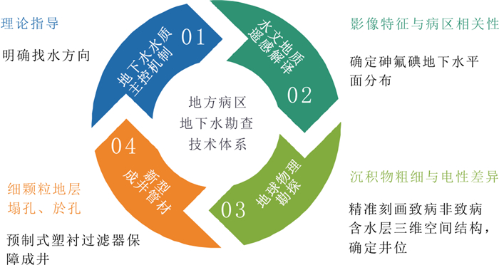
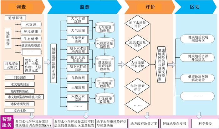
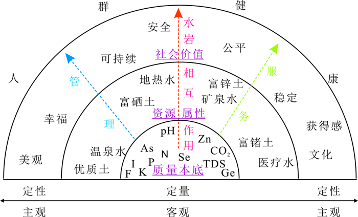
To effectively support the Healthy China Initiative, China is exploring the development of a geohealth survey. However, due to the insufficient understanding of the concept of geohealthy, aunified working philosophy and technical approach have not yet been formed, which restricts the promotion of this work throughout the country.This paper reviewed the latest research results on the investigation and evaluation of soil and water quality and the prevention and control of endemic disease by employing literature research, qualitative analysis and comparative analysis. Special attention was paid to the research ideas and latest progress of endemic diseases such as fluorosis, arsenism, goiter (including cretinism), Kashin-Beck disease and Keshan disease, which are widely distributed and highly influential in China. It was found that the geohealth survey takes the water and soil quality affecting human health as the core index, which is the major difference between it and the traditional geological surveys.In the geohealth survey, we should ① Strengthen the application of water-rock interaction research methods and groundwater flow system analysis methods, ② Emphasize the analysis of the migration, transformation, and exposure pathways of elements in the earth superficial spheres of lithosphere-soilosphere-hydrosphere-atmosphere-biosphere, and ③ Insist on the principles of combining earth system science and life science, combining systemic monitoring of multi-factors with single-factor dominant observation, combining investigation and monitoring of geological environment and human health indicators, and combining comprehensive regional investigation with the typical case study. It is suggested to orderly promote the tasks of geohealth survey, monitoring, evaluation, zoning and intelligent services, and deploy keyworks such as ensuring safe water supply, providing healthy drinking water, developing high-quality water, delineating inferior plots, developing high-quality arable land, and planning agricultural parks with beneficial elements. A cross-scale background investigation of water and soil quality, resource attribute analysis and social value assessment was proposed, with varying focus on different scales: overall control at the regional scale, fine characterization at the watershed scale, key anatomy monitoring at the village and town scale, and exploration and demonstration of engineering measures at the point. A conceptual framework of the relationship between water and soil quality and human health was constructed, and the control thresholds of key factors were screened to meet the population′s health needs for safety, fairness, happiness, culture, and sustainability. The results of this study clarify the core tasks and main directions of the current geohealth survey, providing a reference for decision-making in the advancement and deployment of this work, which is still in the exploratory stage.

Analysis of the carbon stock and carbon neutral potential of wetlands in Guizhou Province
Zhang Meiqi, Chen Bo, Zhao Min
2023, 42(2): 315-326. doi: 10.19509/j.cnki.dzkq.tb20220358
Abstract:

As a key ecosystem for climate change mitigation, wetlands play an irreplaceable role in carbon capture and sequestration. The analysis of wetland carbon stocks and their influencing factors, as well as the prediction of carbon sequestration potential, are of great significance to the conservation and management of wetlands and the achievement of the national "double carbon" target.This study employed ArcGIS 10.8 to vectorize the wetland distribution map of the Wetland Protection and Development Plan of Guizhou Province (hereinafter referred to as the Plan) for three periods (1999-2009, 2010-2018, and 2018-present, respectively) by means of remote sensing visual interpretation and zoned them according to the intensity of karst development in Guizhou Province. The changes in wetland area and carbon stock in Guizhou Province were estimated and analyzed using the life belt research method and biomass estimation method, and the total carbon stock and carbon stock per unit area of key wetlands were estimated and compared with those of all wetlands in Guizhou Province. A calculation model was used to estimate the carbon sequestration potential of the key wetlands in Guizhou Province.The Origin software was applied to analyze the data on all relevant impact factors. The results showed that: ①The area of wetlands in Guizhou Province was 216, 526.95 hm2, 209, 726.85 hm2, and 255, 440.53 hm2 in the pre-, mid-, and late-planning periods, respectively, with an overall decrease and then increase, and the total area increased by 38, 913.58 hm2; ② The wetland carbon stock in Guizhou Province was 3.78×10⁶ t in the late stage of planning, increasing significantly to more than 6 times of that in the early stage of planning(5.97×10⁵ t), among which the carbon stock of the key wetlands was 3.24×10⁶ t, accounting for 85.71% of the province's wetland carbon stock; ③ The carbon sequestration potential of the keywetlands in Guizhou Provincewas 1.14×10⁴ t C/a, and the total carbon sequestration of wetlands is expected to reach 7.99×10⁶ t C and 8.34×10⁶ t C by 2030 and 2060, respectively; and ④ The carbon stock of the key wetlands was positively correlated with DIC concentration, organic carbon content and wetland area and negatively correlated with temperature, indicating thattemperature, DIC concentration, organic carbon content and wetland area had a strong influence on the carbon stock of the key wetlands in Guizhou Province.The results of this study will not only facilitate the understanding of the current status of wetland carbon sequestration in Guizhou Province but also provide a theoretical reference for the contribution of regional wetland ecosystems to the "3060" dual carbon target.

Sensitivity analysis of upscaling prediction of the mass flux at DNAPL contaminated sites
Song Meiyu, Shi Xiaoqing, Kang Xueyuan, Wu Jichun
2023, 42(2): 327-335. doi: 10.19509/j.cnki.dzkq.tb20220262
Abstract:

Dense nonaqueous phase liquid (DNAPL) contamination is a growing problem. To assess the environmental risk of DNAPL-contaminated sites, the mass flux of the dissolved phase (mass flux) in the source zone of DNAPL contamination is often extrapolated using upscaling models. Due to the large number of parameters in the upscaling model and the high cost of investigation, the key parameters in the model need to be screened to guide the design of a reasonable observation data collection scheme for actual contaminated sites. In this paper, a global sensitivity analysis was first conducted on six parameters (mean groundwater velocity q, standardized concentration C0/Ceq, the mass ratio of ganglia GF0, the fraction of the mass flux attributable to the ganglia dissolution fg, and fitting parameters β1 and β2) in the upscaling model to identify the key parameters, and then a local sensitivity analysis was used to quantify the impact of changes in the key parameters on mass flux prediction. The results showed that the parameters q, C0/Ceq, GF0 and fg had a large impact on the mass flux prediction. The sensitivities of q and C0/Ceq were relatively high throughout the depletion process, while those of GF0 and fg increased continuously with the depletion process, reaching peaks in the middle and late stages of depletion, respectively. For source zones with different structures, the increase in mass flux was essentially constant when q or C0/Ceq increased. As the ganglia-to-pool (GTP) mass ratio increased in source zones, its effect on the mass flux prediction continued to increase or decrease when GF0 or fg increased. Therefore, the investigation needs to focus on q and C0/Ceq when predicting the mass flux, on GF0 when reasonably designing the remediation plan of the source zone, and on fg when predicting the lifetime of the source zone. For all structural source zones, q and C0/Ceq are the most important to investigate, and the investigation cost should be focused on GF0 for source zones with large GTP and fg for source zones with small GTP.

Water sources of typical plants during the rainy season in desertification areas of the agro-pastoral ecotone in northern China
Huang Peng, Zhou Aiguo, Ma Chuanming, Liu Zuo, Zhang Zechen, Bai Yaonan
2023, 42(2): 336-346. doi: 10.19509/j.cnki.dzkq.tb20210474
Abstract:

The agro-pastoral ecotone in northern China is an important ecological security barrier for central and eastern China. Ecological restoration in this zone is very important due to its fragile ecosystem structure, frequent ecological and environmental problems, and severe land desertification. The plant-soil water relationship is essential to ecological and hydrological processes in land desertification areas. Studying the water conversion process between plants and soil is of great importance for understanding the water absorption patterns of plants and determining the preferred plant species for ecological restoration. Taking northern Kangbao County, Zhangjiakou City, Hebei Province as the study area, this study analyzed the water uptake layer, ecological niche width, and water competition of typical plants based on the hydrogen and oxygen isotopic characteristics of rainfall, groundwater, soil water, and xylem water during the rainy season, were analyzed. The results showed that Caragana korshinskii mainly absorbed soil water at a depth of 80-100 cm, with a maximum water uptake rate of 87.7%, while Brassica campestris mainly absorbed soil water at a depth of 0-20 cm, with a maximum water uptake rate of 82.3%. The water absorption layer of Stipa baicalensis was related to the soil moisture content, and the depth of water absorption of Neopallasia pectinata was more balanced. The ecological niche of each plant species is relatively wide, but there is intense water competition among some plants. This study provides a scientific basis for identifying plant water sources and ecological restoration in desertification areas of the agro-pastoral ecotone in northern China.

A study of petrophysical properties based on digital core technology: A case study of a porous carbonate reservoir in the overseas J Oilfield
Zhao Huawei, Lian Peiqing, Yi Jie, Duan Taizhong, Zhang Wenbiao, Liu Yanfeng
2023, 42(2): 347-355. doi: 10.19509/j.cnki.dzkq.tb20210522
Abstract:

Developing overseas petroleum exploration and production businesses is a necessary way to guarantee the energy security in China. However, in evaluating overseas reservoirs or designing development plans, due to lack of the first-hand data, the pore structures and seepage mechanisms cannot be well understood and the evaluation effects are influenced. In this study, with the porous carbonate reservoir of the overseas J Oilfield as a case study, the digital core technology is proposed to analyze the pore structure and seepage mechanism. ①With the thin section images of different flow units as the input data, after preprocessing of the medium filtering and threshold segmentation, the digital cores are reconstructed based on the Markov Chain Monte Carlo numerical reconstruction algorithm. ②The bore throat distribution, pore throat connectivity and porosity of the digital cores are analyzed. ③The lattice Boltzmann method is adopted to perform a single phase and two phase oil-water flow simulation in the digital cores, and the absolute permeability and relative permeability curves are calculated based on the simulation results. The reconstructed three-dimensional digital core can describe the differential characteristics of the pore throat radius distribution and pore throat connectivity of porous carbonate rocks in different flow units. The digital core porosity is highly consistent with the porosity of thin section images, and the digital core permeability shows a good positive correlation with the core permeability, thus conforming to the flow unit of the real core. The relative permeability curves of oil-water two-phase flow simulation show differences in the two-phase seepage capacity of different flow units, which can be used as the input of numerical simulation and the estimation of reservoir recovery. The results of digital core analysis are consistent with the results of physical experiments, thus verifying the reliability of the digital core analysis technique. This study provides a new strategy for reservoir evaluation and seepage study in case of data insufficiency and is valuable for reservoir description and effective development.

Experiment research of the influence of different cooling times on the drillability of high-temperature granite
Chen Shuai, Shi Xiangchao, Gao Leiyu, Tang Yang, Li Qingling
2023, 42(2): 356-364. doi: 10.19509/j.cnki.dzkq.2022.0102
Abstract:

To study the drillability and microscopic damage changes of granite after high temperature exposure and to study the influence of different cooling times on drillability after high temperature exposure, granite for high-temperature heat treatment was cooled by different times (2 h, 4 h, 24 h, and 48 h). Through the drillability experiment and the cast thin identification of the processed rock samples, the influence law and mechanism of high temperature on the drillability of granite were obtained, and the influence of different cooling times on the granite drillability was also investigated. The research results show that granite always maintains a high drillability index under the constraints of heat treatment not exceeding 500℃ and natural cooling for 2 h. After cooling 4 h, 24 h, and 48 h, the impact of high temperature on drillability shows three stages (First degradation stage, strengthening stage, second degradation stage). The location and number of microcracks affect the difficulty of rock resistance to crushing. After 400℃ heat treatment, the internal microcracks of the granite begin to increase significantly. When the microcracks generate a large number of microcracks inside the quartz particles, the drillability of the granite is significantly reduced. After heat treatment at 100℃, cooling for no more than 4 h at the same time will significantly affect the drillability of granite. After heat treatment at 200-400℃, the drillability index of granite will increase significantly as the cooling time (4-48 h) continues to increase. The damage caused by 500℃ to granite is irreversible, and 600℃ has completely degraded the granite. Understanding the influence of high temperature and cooling time on the drillability of granite can provide basic theoretical support for the efficient exploitation of hot dry rock resources.